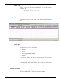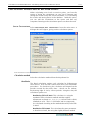
1
NoiseMap fi√e User Reference Manual The features described in this User Guide may not be available on all installations. NoiseMap Ltd reserves the right to alter products and specifications without notification. The operation and appearance of features may differ from the description in this User Guide. See on-line help or our website for information on any changes made since the publication of this manual. We would be grateful if users would bring any discrepancies to our attention. Edition 5.0.26 © 2003 - 2012 NoiseMap Ltd. All rights reserved. February 2013 NoiseMap Ltd 26 Hamilton Close EPSOM, KT19 8RG United Kingdom Tel: +44 (0) 3355 9734 E-mail: [email protected] Contents: Noisemap Five – Principal Features 1:1 1. CONTENTS 1. Contents ..................................................................................................................................... 1:1 2. The basics of NoiseMap Five ...................................................................................................... 2:1 NoiseMap Five – Principal features .......................................................................................... 2:1 Upgrading from NoiseMap Enterprise Edition .................................................................... 2:2 Using this manual and obtaining other help ............................................................................. 2:2 Introduction to NoiseMap ........................................................................................................ 2:3 Automated modelling ........................................................................................................ 2:3 Interface with GIS and CAD ............................................................................................... 2:3 Models of any size and complexity ................................................................................... 2:3 Collaborative working ....................................................................................................... 2:3 Scripting ............................................................................................................................ 2:4 Presentation-ready mapping ............................................................................................... 2:4 Presentation over the Web ................................................................................................. 2:4 Database technology ......................................................................................................... 2:4 Maintains compatibility ..................................................................................................... 2:5 Accuracy ........................................................................................................................... 2:5 Flexible licences ................................................................................................................ 2:5 Changing from NoiseMap Enterprise to NoiseMap five............................................................. 2:6 Differences from Enterprise version.................................................................................... 2:6 Databases defined ............................................................................................................. 2:6 Database simplicity............................................................................................................ 2:6 Small schemes also benefit ................................................................................................ 2:7 Automatic tracking of scheme changes .............................................................................. 2:7 Computer hardware ........................................................................................................... 2:7 Internet connections are not essential ................................................................................ 2:8 Internet security ................................................................................................................. 2:8 SSH ................................................................................................................................... 2:9 Installation ............................................................................................................................... 2:9 Dongles ............................................................................................................................. 2:9 Licence scope .................................................................................................................... 2:9 The database .......................................................................................................................... 2:10 Remote database ............................................................................................................. 2:10 Stand-alone database ....................................................................................................... 2:10 Map Tiles......................................................................................................................... 2:10 Database previewer ......................................................................................................... 2:11 Database Server machine ................................................................................................. 2:11 Database administration .................................................................................................. 2:12 3. NoiseMap models....................................................................................................................... 3:1 Introduction ............................................................................................................................. 3:1 Height information ............................................................................................................ 3:3 Structure of a RoadNoise model ............................................................................................... 3:3 Structure of a SiteNoise Model ................................................................................................. 3:4 Sequence of modelling ...................................................................................................... 3:5 Positioning Activities at Working Locations........................................................................ 3:6 Activities Explained ........................................................................................................... 3:6 Scenarios ........................................................................................................................... 3:7 Assessment period.................................................................................................................... 3:8 Structure of a Railnoise model .................................................................................................. 3:8 Creating a RailNoise Model ............................................................................................... 3:9 NoiseMap fi√e: User Manual 1:1 1:2 User Manual: NoiseMap fi√e Sequence of modelling ............................................................................................................ 3:9 Positioning Services onto Tracks ...................................................................................... 3:10 Train Services Explained ........................................................................................................ 3:10 Scenarios......................................................................................................................... 3:11 Assessment period ................................................................................................................. 3:12 4. Creating Noise Models ............................................................................................................... 4:1 Starting the software................................................................................................................. 4:1 New schemes – Scenarios and databases ................................................................................. 4:1 Creating a new database .......................................................................................................... 4:1 Creating and Editing noise models ........................................................................................... 4:2 Connecting to database ............................................................................................................ 4:2 Stand-alone database ......................................................................................................... 4:2 Remote database ............................................................................................................... 4:2 Options for loading noise modelling data ................................................................................ 4:3 Recent Databases ..................................................................................................................... 4:3 Database previewer ................................................................................................................. 4:4 Starting the Database Previewer ........................................................................................ 4:5 Selecting tiles in the Previewer .......................................................................................... 4:7 Downloading from database.............................................................................................. 4:7 Rules of inheritance ................................................................................................................. 4:8 Loading tiles from database ...................................................................................................... 4:8 Select Scenario .................................................................................................................. 4:9 Import existing NoiseMap Enterprise Models ........................................................................... 4:9 Import existing archive........................................................................................................... 4:10 Introduction to archives ................................................................................................... 4:10 Commence archive Import .............................................................................................. 4:11 Merging archives and masterfiles into an existing model ........................................................ 4:11 Consistency checks ......................................................................................................... 4:11 Merging Categories and Combinations ............................................................................ 4:12 Traffic flow ID numbers................................................................................................... 4:13 Creating and updating NoiseMap Models .............................................................................. 4:13 DXF digital drawing Files ....................................................................................................... 4:14 Introduction .................................................................................................................... 4:14 Height Information .......................................................................................................... 4:15 Automatic Height Generation .......................................................................................... 4:16 Loading a DXF File ................................................................................................................ 4:16 Controlling the detail in the DXF View................................................................................... 4:18 Model Display................................................................................................................. 4:19 Convert DXF Selection ........................................................................................................... 4:20 Shapefiles .............................................................................................................................. 4:22 Introduction to Shapefiles ................................................................................................ 4:22 Loading a Shapefile ......................................................................................................... 4:23 Shapefile Profile (column mappings) ............................................................................... 4:23 Automated model creation..................................................................................................... 4:26 Roads .............................................................................................................................. 4:27 Tracks, Workings, Barriers, Receivers .............................................................................. 4:28 Outline ........................................................................................................................... 4:28 Hard/Soft Ground outlines............................................................................................... 4:29 Top/Bottom of slope ........................................................................................................ 4:29 Conversion Tolerance ..................................................................................................... 4:29 Automatically generate height ......................................................................................... 4:30 Edit convert layer defaults ...................................................................................................... 4:30 Segment Tools ....................................................................................................................... 4:31 Set local height................................................................................................................ 4:31 Set retained cut ............................................................................................................... 4:31 Reverse segment chain (Shortcut ctrl-x)............................................................................ 4:32 Delete contours from segments ....................................................................................... 4:32 Hard ground outlines ............................................................................................................. 4:32 Adding Building outlines ....................................................................................................... 4:32 1:2 Contents: Noisemap Five – Principal Features Contents: Noisemap Five – Principal Features 1:3 Select method of adding building outlines ....................................................................... 4:33 Marking out and annotating Noise Models ............................................................................. 4:34 Adding areas and annotation manually ............................................................................ 4:35 Displaying the Area or Annotation labels ......................................................................... 4:35 Calculation Parameters ........................................................................................................... 4:36 General Calculation Parameters ....................................................................................... 4:36 CRTN Road Calculations ................................................................................................. 4:37 BS5228 SiteNoise Calculations ........................................................................................ 4:37 Storing the Calculation Parameters................................................................................... 4:38 Categories and combinations ................................................................................................. 4:38 Edit barrier adjustments .......................................................................................................... 4:40 Program Options .................................................................................................................... 4:40 General options ............................................................................................................... 4:41 Model Editing .................................................................................................................. 4:42 Model Loading ................................................................................................................ 4:42 Popups and Messages ...................................................................................................... 4:43 Working with Bitmaps ............................................................................................................ 4:43 Scanning bitmaps ............................................................................................................ 4:44 Loading a bitmap ............................................................................................................. 4:44 World Files ...................................................................................................................... 4:44 Bitmap calibration ........................................................................................................... 4:44 Saving calibrated bitmaps ................................................................................................ 4:45 Locating the bitmap ......................................................................................................... 4:45 Moving around the bitmap .............................................................................................. 4:45 Turning the Bitmap on and off ......................................................................................... 4:45 5. Navigation and Editing................................................................................................................ 5:1 Basic operation ........................................................................................................................ 5:1 The Graphical Window ..................................................................................................... 5:1 Navigation ............................................................................................................................... 5:2 With mouse wheel ............................................................................................................ 5:3 With cursor keys ................................................................................................................ 5:3 With toolbar buttons .......................................................................................................... 5:3 Find ......................................................................................................................................... 5:4 Find next (F3) .................................................................................................................... 5:5 Postcodes ................................................................................................................................. 5:5 Selecting an Object .................................................................................................................. 5:5 Point and click................................................................................................................... 5:5 Enclosure method .............................................................................................................. 5:6 Complete chain selection .................................................................................................. 5:6 Find ................................................................................................................................... 5:6 Manager screens ................................................................................................................ 5:6 Object properties window ........................................................................................................ 5:7 Moving Objects ....................................................................................................................... 5:7 Split Object .............................................................................................................................. 5:7 Break chain .............................................................................................................................. 5:8 Copying Objects ...................................................................................................................... 5:8 Deleting objects ....................................................................................................................... 5:8 Delete Selection ................................................................................................................ 5:8 Undo and Redo ........................................................................................................................ 5:9 Undo ................................................................................................................................. 5:9 Redo .................................................................................................................................. 5:9 Navigating along line objects ................................................................................................... 5:9 Road segments................................................................................................................... 5:9 Edit object co-ordinates .......................................................................................................... 5:10 Measuring tool ....................................................................................................................... 5:10 Contours ................................................................................................................................ 5:11 Ground Height and Ground Type .................................................................................... 5:11 Ground Height Contours ................................................................................................. 5:11 Ground type outlines ....................................................................................................... 5:13 NoiseMap fi√e: User Manual 1:3 1:4 User Manual: NoiseMap fi√e Spot Height Chain ................................................................................................................. 5:15 Barriers .................................................................................................................................. 5:16 Height adjustment ........................................................................................................... 5:19 Receivers ............................................................................................................................... 5:20 Saving changes ...................................................................................................................... 5:20 Conflict checking ............................................................................................................ 5:20 Optimise Database ................................................................................................................ 5:21 6. Road Noise Modelling ................................................................................................................ 6:1 Starting the software................................................................................................................. 6:1 Traffic Flow Data ..................................................................................................................... 6:1 Changing traffic flow data.................................................................................................. 6:2 Manual entry using the Traffic Flow Dialogue Box............................................................. 6:3 Importing traffic flows from a spreadsheet ......................................................................... 6:6 Segments ................................................................................................................................. 6:7 Road Segment Properties ................................................................................................... 6:8 Object Position ................................................................................................................. 6:8 Road Parameters ............................................................................................................... 6:9 Carriageway Properties .................................................................................................... 6:11 Retained cut setting ......................................................................................................... 6:14 Next segment .................................................................................................................. 6:15 7. Site Noise Modelling .................................................................................................................. 7:1 Starting the software................................................................................................................. 7:1 Adding plant data .................................................................................................................... 7:1 Importing and exporting plant data .......................................................................................... 7:2 Adding activities ...................................................................................................................... 7:3 Adding working locations ........................................................................................................ 7:4 Putting Activities Into Working Locations ................................................................................. 7:5 Multiple working locations ................................................................................................ 7:6 Importing and exporting Activities ........................................................................................... 7:7 Importing Activities into an existing noise model ............................................................... 7:8 Presentation of Workings and activities on graphical screen ..................................................... 7:9 Assigning categories............................................................................................................... 7:11 8. Rail Noise modelling .................................................................................................................. 8:1 Starting the software................................................................................................................. 8:1 Adding railway Train vehicle data ............................................................................................ 8:1 Importing train vehicles ..................................................................................................... 8:2 Adding train services................................................................................................................ 8:2 Adding segments of track ......................................................................................................... 8:4 Putting Train services Into Segments of track ..................................................................... 8:6 Presentation of Railway Tracks on graphical screen .................................................................. 8:7 Assigning categories................................................................................................................. 8:7 RailNoise Calculations ............................................................................................................. 8:8 9. Scenarios .................................................................................................................................... 9:1 Scenarios Explained ................................................................................................................. 9:1 Scenario manager .................................................................................................................... 9:2 Rules of inheritance ................................................................................................................. 9:3 Geographical objects......................................................................................................... 9:4 Information not specific to particular tiles or scenarios ............................................................. 9:4 Calculation parameters ...................................................................................................... 9:5 Barrier height adjustments ................................................................................................. 9:5 RailNoise Objects ............................................................................................................. 9:5 SiteNoise Objects .............................................................................................................. 9:6 RoadNoise Objects ........................................................................................................... 9:7 10. Noise Contouring ................................................................................................................... 10:1 1:4 Contents: Noisemap Five – Principal Features Contents: Noisemap Five – Principal Features 1:5 Noise contouring ................................................................................................................... 10:1 Introduction to NoiseMap features ................................................................................... 10:1 Calculate database noise contours .......................................................................................... 10:1 Choice of calculation method ................................................................................................ 10:4 Compare Database Contours .................................................................................................. 10:6 Load database noise contours ................................................................................................. 10:7 Valid and Invalid Contours .............................................................................................. 10:8 Contour display parameters .................................................................................................... 10:9 Show contour .................................................................................................................. 10:9 Contour display ............................................................................................................. 10:12 Contour labels ............................................................................................................... 10:12 Drawing method............................................................................................................ 10:12 Contour scale ................................................................................................................ 10:12 Contour intervals ........................................................................................................... 10:13 Choosing particular contour values ................................................................................ 10:13 Contour interval boundaries .......................................................................................... 10:14 Changing the way that noise contours are displayed ............................................................. 10:15 Close Contour ...................................................................................................................... 10:15 Display contour Area Breakdown ......................................................................................... 10:15 Jagged Contours ................................................................................................................... 10:15 Contour Calculation process ................................................................................................ 10:16 Combined source modelling ................................................................................................ 10:17 Stopping NoiseMap .............................................................................................................. 10:17 Clear NoiseMap............................................................................................................. 10:17 Exit ................................................................................................................................ 10:17 Quit............................................................................................................................... 10:17 Abort ............................................................................................................................. 10:17 Abort at end .................................................................................................................. 10:17 11. Calculation at individual receivers .......................................................................................... 11:1 Introduction ........................................................................................................................... 11:1 Entering individual receiver points manually .......................................................................... 11:2 Receiver properties screen in detail.................................................................................. 11:3 Generation of a grid of receivers ............................................................................................ 11:5 Automatic generation of receiver points around building facades ........................................... 11:8 Calculating noise levels at receiver points ............................................................................ 11:11 Local Calculation ........................................................................................................... 11:11 Calculate database receivers ................................................................................................. 11:14 Load Receiver Results........................................................................................................... 11:15 Display receiver results ........................................................................................................ 11:15 Export Receiver Results ........................................................................................................ 11:15 Show source contribution at receiver ................................................................................... 11:15 12. Saving and exporting results ................................................................................................... 12:1 Export ShapeFiles ................................................................................................................... 12:1 Export Picture......................................................................................................................... 12:2 Copy view to Clipboard (Crtl+C)..................................................................................... 12:2 Export DXF............................................................................................................................. 12:2 Export Contour Data .............................................................................................................. 12:3 Comma-delimited ascii output ......................................................................................... 12:3 ESRI Grid Format ............................................................................................................. 12:4 Export Archive ....................................................................................................................... 12:5 Exporting a scenario ............................................................................................................... 12:5 Exporting Traffic Flows ........................................................................................................... 12:6 Export Train Vehicles ............................................................................................................. 12:6 Export Plant............................................................................................................................ 12:7 Saving the Output window ..................................................................................................... 12:7 Results Report (ROP) File ....................................................................................................... 12:7 Exporting to Excel .................................................................................................................. 12:7 NoiseMap fi√e: User Manual 1:5 1:6 User Manual: NoiseMap fi√e 13. Features for checking models ................................................................................................. 13:1 View-As-Colour ..................................................................................................................... 13:1 Parameter to colour ......................................................................................................... 13:1 Parameter options ........................................................................................................... 13:2 Colour scale limits........................................................................................................... 13:2 Update view.................................................................................................................... 13:2 Labelling the model ............................................................................................................... 13:3 Display Options Menu .................................................................................................... 13:3 Types View ..................................................................................................................... 13:3 Labels View..................................................................................................................... 13:4 General ........................................................................................................................... 13:5 Cross-sections and long-sections ............................................................................................ 13:5 Vertical noise contours .................................................................................................... 13:7 3-D Viewing .......................................................................................................................... 13:7 Generating 3-D files ........................................................................................................ 13:8 The 3-D viewer ...................................................................................................................... 13:9 Hints on viewing ........................................................................................................... 13:11 Trouble-shooting 3-d viewer .......................................................................................... 13:12 Software filling of noise contours ................................................................................... 13:12 Checking for Duplicate Objects ........................................................................................... 13:12 14. Distributed Calculations ......................................................................................................... 14:1 Introduction ........................................................................................................................... 14:1 Setting up a computer to listen to the Calculation Queue ....................................................... 14:1 Adding tasks to the Calculation queue ................................................................................... 14:2 Queued information .............................................................................................................. 14:3 Speed of computation ............................................................................................................ 14:3 Loss of internet connection .................................................................................................... 14:4 Calculation-only licence ........................................................................................................ 14:4 Read-only database permissions ............................................................................................. 14:4 15. Graphical output and Printing ................................................................................................ 15:1 Introduction ........................................................................................................................... 15:1 Printing or Plotting a Model ................................................................................................... 15:1 Copy view to clipboard.......................................................................................................... 15:3 16. The results output window ..................................................................................................... 16:1 Introduction ........................................................................................................................... 16:1 Positioning the results output window ................................................................................... 16:2 Script command pane ............................................................................................................ 16:2 Saving the results output window........................................................................................... 16:2 Find function ......................................................................................................................... 16:3 View Functions ...................................................................................................................... 16:3 Show all output ............................................................................................................... 16:3 Show all error messages .................................................................................................. 16:3 Display model parameters ............................................................................................... 16:3 Calculate Functions ............................................................................................................... 16:4 Receiver calculations ....................................................................................................... 16:4 Display contour area breakdown ..................................................................................... 16:4 Output ................................................................................................................................... 16:4 Selecting output detail ............................................................................................................ 16:4 Full Output ...................................................................................................................... 16:4 One line per segment Output .......................................................................................... 16:2 Summary printout ........................................................................................................... 16:3 Output interpretation .............................................................................................................. 16:3 Height adjustment ........................................................................................................... 16:3 Receiver details ............................................................................................................... 16:4 Segment Number ............................................................................................................ 16:4 Contour Analysis ............................................................................................................. 16:4 1:6 Contents: Noisemap Five – Principal Features Contents: Noisemap Five – Principal Features 1:7 Possible Barriers .............................................................................................................. 16:4 Effective Barriers .............................................................................................................. 16:4 RoadNoise output .................................................................................................................. 16:5 Segment Summary Line ................................................................................................... 16:5 SiteNoise output..................................................................................................................... 16:7 Activity Summary Line ..................................................................................................... 16:8 RailNoise Output ................................................................................................................. 16:10 Segment Summary Line ................................................................................................. 16:10 Summary Of Model .............................................................................................................. 16:12 17. NoiseMap Script Interface ....................................................................................................... 17:1 Script commands.................................................................................................................... 17:1 Script Command Pane ............................................................................................................ 17:1 Script Files ............................................................................................................................. 17:2 Creating a Script file ............................................................................................................... 17:3 Script Variables ...................................................................................................................... 17:4 List of commands............................................................................................................. 17:5 18. Database setup and Administration ......................................................................................... 18:1 Stand-alone databases ............................................................................................................ 18:1 Remote databases................................................................................................................... 18:1 Setting up a Connection to a remote database server .............................................................. 18:1 Installing a server and database .............................................................................................. 18:2 MySQL ............................................................................................................................ 18:2 Database Administration ........................................................................................................ 18:2 The Database Administrator ............................................................................................. 18:2 User permissions ............................................................................................................. 18:3 The calculation queue ..................................................................................................... 18:3 Copying a database ................................................................................................................ 18:3 Database Versions .................................................................................................................. 18:4 Capacity of NoiseMap ............................................................................................................ 18:4 19. Updates and Maintenance ...................................................................................................... 19:1 Continuous development ....................................................................................................... 19:1 Version check .................................................................................................................. 19:1 Automatic updates ........................................................................................................... 19:1 Maintenance contracts ..................................................................................................... 19:1 Licence updates ............................................................................................................... 19:2 Update Pay-As-You-Go........................................................................................................... 19:2 Options ........................................................................................................................... 19:3 Get new code ........................................................................................................................ 19:3 Checking and refreshing available user time ........................................................................... 19:4 Using time ....................................................................................................................... 19:4 Checking and refreshing available user time .................................................................... 19:5 Cost of User Time .................................................................................................................. 19:5 20. Default shapefile format .......................................................................................................... 20:1 Shapefile usage in NoiseMap ................................................................................................. 20:1 Preset shapefile format ........................................................................................................... 20:1 21. Menu Structure ....................................................................................................................... 21:1 Main graphical screen menu .................................................................................................. 21:1 All Output (Log/results) screen menu ...................................................................................... 21:3 Keyboard shortcut summary ................................................................................................... 21:4 22. Index ...................................................................................................................................... 22:1 NoiseMap fi√e: User Manual 1:7 1:8 User Manual: NoiseMap fi√e TABLE OF FIGURES Sequence of creating a SiteNoise model ......................................................................................................... 3:5 Sequence of creating a Railnoise model ........................................................................................................ 3:10 NoiseMap Remote Server Login ..................................................................................................................... 4:3 Database Previewer Dialogue ........................................................................................................................ 4:5 Importing categories and combinations ........................................................................................................ 4:12 OS Landline – Layer numbers (Selected) ....................................................................................................... 4:18 DXF Viewing Options .................................................................................................................................. 4:18 DXF Curve Fitting Dialogue ......................................................................................................................... 4:21 Shapefile column mappings (profile) ............................................................................................................. 4:24 An example of Annotation: .......................................................................................................................... 4:34 Calculation parameters................................................................................................................................. 4:36 Category parameters .................................................................................................................................... 4:39 Program options ........................................................................................................................................... 4:41 Find dialogue box .......................................................................................................................................... 5:5 Ground height contours ............................................................................................................................... 5:13 Ground Type Outlines ................................................................................................................................. 5:14 Single barrier properties screen .................................................................................................................... 5:18 Traffic Flows dialogue box (part) .................................................................................................................... 6:4 Traffic flow import format .............................................................................................................................. 6:6 Road segment properties ................................................................................................................................ 6:7 Heights .......................................................................................................................................................... 6:9 Carriageway Width ...................................................................................................................................... 6:12 Carriageway Separation................................................................................................................................ 6:13 Retained cut parameters ............................................................................................................................... 6:14 Plant manager ................................................................................................................................................ 7:2 Activity manager ............................................................................................................................................ 7:3 Add objects ................................................................................................................................................... 7:4 Working location properties ........................................................................................................................... 7:6 Activity import format .................................................................................................................................... 7:7 Presentation of fixed workings on-screen ........................................................................................................ 7:9 Presentation of route workings on-screen ...................................................................................................... 7:10 Presentation of fixed and route workings with activities assigned .................................................................. 7:10 Category parameters .................................................................................................................................... 7:11 Train vehicle manager .................................................................................................................................... 8:2 Train service manager .................................................................................................................................... 8:3 Add track segments ........................................................................................................................................ 8:4 Track segment properties ............................................................................................................................... 8:5 Presentation of railway tracks on graphical screen .......................................................................................... 8:7 Category parameters in RailNoise ................................................................................................................... 8:8 Contour calculation options ......................................................................................................................... 10:2 Contour calculation resolution ..................................................................................................................... 10:3 Contour display parameters ........................................................................................................................ 10:10 Measuring limits of field of view .................................................................................................................. 11:2 Receiver properties screen ........................................................................................................................... 11:3 Receiver grid properties screen..................................................................................................................... 11:6 Example of receiver grid ............................................................................................................................... 11:7 Receiver grid with noise levels displayed in colour ....................................................................................... 11:7 Vertical cross-section of Receiver grid with noise levels displayed in colour .................................................. 11:8 Generate façade receivers ............................................................................................................................ 11:9 Receivers generated by above settings ........................................................................................................ 11:10 Local calculation of receiver noise levels .................................................................................................... 11:11 Train vehicle export format .......................................................................................................................... 12:6 Plant export format ...................................................................................................................................... 12:7 Cross-section view ....................................................................................................................................... 13:6 Receiver noise level colours ......................................................................................................................... 13:9 Duplicate Checking ................................................................................................................................... 13:13 Full Output................................................................................................................................................... 16:2 One line per segment output ........................................................................................................................ 16:3 Summary Printout ......................................................................................................................................... 16:3 Activity Summary Line ................................................................................................................................. 16:8 Summary of script commands ...................................................................................................................... 17:7 Add new server connection .......................................................................................................................... 18:1 1:8 Contents: Noisemap Five – Principal Features The Basics Of Noisemap Five: Noisemap Five – Principal Features 2. THE BASICS OF NOISEMAP FIVE NOISEMAP FIVE – PRINCIPAL FEATURES NoiseMap five is fully-professional software for the assessment of environmental noise from road, railway and all type of open-site and industrial projects. It has been developed by acoustics, civil, transportation and software engineering professionals to provide all the functionality needed in noise mapping and assessment, in the evaluation and evolution of projects, including the design of mitigation, the evaluation of alternatives and in the provision of impact assessments. It incorporates the experience gained in over 25 years’ use on thousands of projects, ranging from the very smallest to the very largest: models can be of practically unlimited size. The features, user interface and tools are designed to make it easy to get results without a specialist understanding of noise calculation procedures, and NoiseMap five is backwardscompatible so that models developed in earlier versions can take advantage of the latest features. NoiseMap five provides all the functionality of NoiseMap Server Edition along with many extra features, including the option to use it in stand-alone mode which does not require a specialist database server. Stand-alone mode provides all the modelling features of the database server mode, and can handle large databases for users who do not need distributed calculations or multiple concurrent users. Huge models such as those containing hundreds of kilometres of roads or hundreds of scenarios, and those with intensive calculation needs should continue to use the robust and powerful dedicated database server system. NoiseMap five integrates RoadNoise, SiteNoise and RailNoise calculations into a single module. The use of ‘persistent’ properties windows for most types of object lets users with wide screen displays position these at the side of the main graphical window or even on a second display screen. Some property windows are linked: for example, when you select a road segment, the traffic flow window (if open) will automatically show the full properties of the relevant traffic flow. NoiseMap five also has a more advanced scripting interface that allows many repetitive modelling processes to be automated. When combined with the ability to import and export many model components from spreadsheets, the integration of NoiseMap with external data sources is further improved. NoiseMap fi√e: User Manual 2:1 2:1 2:2 User Manual: NoiseMap fi√e UPGRADING FROM NOISEMAP ENTERPRISE EDITION Existing NoiseMap Enterprise RoadNoise, RailNoise and SiteNoise models can be imported into NoiseMap five, where they can be combined into a single model, or kept as different scenarios. Major benefits for NoiseMap Enterprise users include far superior import of digital models from shapefiles, DXF files and spreadsheets. Full modelling of buildings and generation of receiver points around buildings are now included; and calculation results, both for individual receivers and noise contours, are stored in the database. The NoiseMap Enterprise concept of separate models files to represent different situations is replaced in NoiseMap five by the concept of Scenarios, which represent variations on a base theme. For example, a base scenario could be an existing road network and a second scenario could represent the area with a bypass. Further scenarios could then represent the bypass with a noise barrier, and yet further scenarios could represent different years with different traffic flows. Each scenario can contain any number of road, rail and site noise sources. Noise levels can be calculated for each type of source, and scenarios can be compared to see the difference in noise levels. These tasks are all handled automatically within the software, thereby saving many hours of work. USING THIS MANUAL AND OBTAINING OTHER HELP This manual is a comprehensive User Reference Guide to NoiseMap five and includes guidance on modelling Road, Rail and Site Noise. Separate ‘How to’ guides are available to provide step-by-step guidance on particular tasks, including: Setting up a RoadNoise model Using DXF and Shapefiles How to create vertical noise contours Using category combinations Where the term NoiseMap is used alone, this refers to the latest version, NoiseMap five. Technical reference manuals describe the technical operation of some NoiseMap features, including details of calculation procedures, and are available by applying to NoiseMap Ltd. Context-sensitive help NoiseMap five contains new context-sensitive help, based on the contents of this manual. Press the F1 key at any time the software is running to obtain context-sensitive help. 2:2 The Basics Of Noisemap Five: Using This Manual And Obtaining Other Help The Basics Of Noisemap Five: Introduction To Noisemap This manual This manual is primarily a reference manual rather than a step-by step guide, although the information has been presented in the order that a user would be likely to require it when starting a scheme from scratch. This manual covers the various functions of NoiseMap in detail, with Chapter 21 showing the menu structure and the primary reference for each menu item. An Index provides a quick way of finding particular descriptions. We welcome your comments on the content and presentation of this manual. INTRODUCTION TO NOISEMAP AUTOMATED MODELLING NoiseMap automates much of the work involved in creating the noise models from which noise calculations and noise maps are made. It can convert digital maps directly into noise models with little or no user intervention. This includes the conversion of whole topographical models, building layers, road layers etc., into a noise model. This automation helps to reduce the technical complexity of creating noise maps. It also integrates the modelling of road, rail and site noise sources into a single module. INTERFACE WITH GIS AND CAD Digital maps, noise models and noise maps can be transferred between NoiseMap and Geographical Information Systems (GIS) using standard digital and graphics file formats such as ShapeFiles, DXF and Bitmap. Noise maps can also be transferred in ESRI Grid format and via text files of x, y, h and dB values. MODELS OF ANY SIZE AND COMPLEXITY NoiseMap uses advanced database technology to create noise models and noise maps of any size, from the very simplest to the very largest. It is much easier to track real-world changes to road and rail networks and industrial sites. New proposals and alternatives can be tested without the risk of affecting the baseline model. COLLABORATIVE WORKING As noise models get larger, more people will be involved in creating and using them. This will often require collaborative working by teams of people who may be at different locations. NoiseMap uses a powerful database storage technology to meet these needs. NoiseMap fi√e: User Manual 2:3 2:3 2:4 User Manual: NoiseMap fi√e SCRIPTING The scripting interface allows automation of repetitive tasks, including the importing and conversion of shapefiles, traffic flow files and calculation of noise contours. PRESENTATION-READY MAPPING NoiseMap contains many mapping features, including the creation of building outlines and other ‘feature boundaries’ to delineate such things as modelled area, water features, city boundaries and the like. Presentation-ready maps can be produced from NoiseMap without the need for a separate graphics package. Noise contours can be exported in a variety of tabular and picture formats for use in reports, GIS systems or other software. PRESENTATION OVER THE WEB NoiseMap can create an interactive Web-page version of your model for easy presentation of results. Areas can be selected by tile reference, OS co-ordinates or Post Codes (if the relevant Address-Point data is supplied). DATABASE TECHNOLOGY NoiseMap offers a choice of two database technologies: a stand-alone or flat-file database suitable for moderate schemes with a limited number of users who may have a standalone PC or network access to an ordinary file server, and a powerful remote database system for huge schemes and organisations that work collaboratively and have users needing remote access. Stand-alone databases The stand-alone or flat-file database can be kept on your local computer or on a network drive. It uses a database driver built into the NoiseMap system. It has the advantage that it does not require a dedicated database server and does not require any special administration. However, it does not control user access, or allow multiple concurrent users or distributed processing via a calculation queue. Nevertheless, it is an attractive option for moderate schemes with a limited number of users. Remote server The Remote Server option stores the model in an ‘industrial strength’ database which will usually be remote from the user's workstation. The database ‘engine’ may be located on a network, on an intranet or on the Internet. A comprehensive set of database administration tools allows an ordinary NoiseMap user to set up new databases and users. This database 2:4 The Basics Of Noisemap Five: Introduction To Noisemap The Basics Of Noisemap Five: Introduction To Noisemap administrator controls access to the database by granting users permission to log on to particular databases. Users can be granted different levels of access to model databases, so that some may be able to create noise models, whilst others may only be able to view existing noise maps. ‘Client’ computers (ie the ordinary user’s computers) can share the processing load when huge models are being calculated. This is known as ‘distributed processing’, which can greatly enhance the available computing power without requiring expensive multi-processor or ultra-fast machines. MAINTAINS COMPATIBILITY NoiseMap is compatible with all earlier editions of our Noise software: RoadNoise, RailNoise and SiteNoise, DOS, 98, 2000 Enterprise and Server editions. You can upload archives from these earlier versions into NoiseMap and you can save NoiseMap models back into some earlier archive formats, although obviously you may lose certain advanced information when you do so. ACCURACY NoiseMap uses the native algorithms as set out in the standards with which it complies. Their operation been verified by hundreds of users and NoiseMap Ltd investigates any issues that are brought to our attention. We run test problems whenever the software is updated to check that consistent results are obtained. It is also important that users can create error-free models easily. NoiseMap has a number of tools to assist in this, including View-as-colour (thematic viewing) Flexible labelling of the model Cross-sections and long-sections (with noise levels) 3-d viewing (with noise levels and contours) Viewing source contributions Checking for duplicated objects Calculation log files These are described in Chapter 13 of this manual. FLEXIBLE LICENCES A range of licences are available for NoiseMap. These include ‘Permanent’ licences, Hire, Pay-As-You-Go and Calculation only. Calculation-only licences allow computers to participate in calculations but not to perform any other functions. This is an economical way of obtaining extra computing power when calculating large areas. For example, general-purpose computers could be used to perform calculations overnight. NoiseMap fi√e: User Manual 2:5 2:5 2:6 User Manual: NoiseMap fi√e A licence may allow you to use all three NoiseMap modules (Road, Rail and Site) or it may be limited to one or two modules. Even if your licence is limited to one or two modules, then you can still load a full model. For example, if you have a RoadNoise-only licence, you will be able to load rail tracks and site routes but you will not be able to make any changes to them. This ensures that you always see the full model, even though you cannot change certain parts of it. You should note that menu options that are not permitted by your licence will be greyed-out and you will not be able to select them. Some menu options would also be greyed-out if you are using an older-format database that cannot support these features. You can check which features your licence permits by selecting Help, About from the menu. Licences can be easily upgraded by downloading a code from NoiseMap’s administration database. If you have maintenance, you will also be able to check for and download upgrades from the administration database. CHANGING FROM NOISEMAP ENTERPRISE TO NOISEMAP FIVE DIFFERENCES FROM ENTERPRISE VERSION A NoiseMap five model looks very similar to a NoiseMap Enterprise model: the same objects are there – traffic flows, segments, noise barriers, receptor points and so on. The same editing tools for changing model objects are there as well, so all this will be familiar to the Enterprise user. However, the model is stored in quite a different way, using a database, and the new concepts will require some familiarisation. The reason for using a database is to allow for the very large models that can be created using the new automation tools. DATABASES DEFINED A database is a special form of computer file which is organised so that information can be found quickly. The database contains indexes of individual items for which you are likely to search, speeding up the process. The database system used by NoiseMap is equipped with a powerful search ‘engine’ that allows sophisticated searches to be made. Then, only the required results need be sent to the user. This reduces the amount of network traffic by ensuring that irrelevant information is not sent over the network. DATABASE SIMPLICITY The database helps you to manage large or complex models, especially where you need to test many different variations or stages of a scheme, called ‘scenarios’ in NoiseMap. Existing functions have changed as little as possible. 2:6 The Basics Of Noisemap Five: Changing From Noisemap Enterprise To Noisemap Five The Basics Of Noisemap Five: Changing From Noisemap Enterprise To Noisemap Five For example, if you are using the stand-alone system, you select the database file and load it in the same way that you would with a Masterfile or Archive file. Database Previewer A database previewer shows all the scenarios in the model, and allows you to select the scenario you require. You can divide the noise model into named areas, so you can just load the area of interest from the list of named areas. You can resume work on a recent scenario, just by selecting it from the ‘recently used’ list. Using the remote system is virtually the same: you simply need to select the server first, which is just like selecting the right network drive when downloading an ordinary file, and then select the database you require. SMALL SCHEMES ALSO BENEFIT Even in small schemes you will need to do a ‘before’ and ‘after’ model for comparison of impacts. It is much easier to create these different models because of the way that NoiseMap lets you put in the differences and save as a new scenario. There is no need to worry about which model files contain which differences. The scenario handling facilities look after this automatically. Automated model creation increases the cost-effectiveness of computerising the smallest models. Improved mapping also benefits the presentation of schemes whatever their size. AUTOMATIC TRACKING OF SCHEME CHANGES With NoiseMap, it is much easier to track changes to a scheme, because you can save them as different scenarios within one database. Furthermore, NoiseMap remembers which tiles were included in each calculation, so that if you make a change to those tiles, the result will be marked as ‘invalid’. When you reload the result, either as an individual calculation or a contour, you will be warned and you can choose whether to re-do the affected results. COMPUTER HARDWARE NoiseMap is tested to work with Window XP, Vista and 7. In common with other CAD/GIS applications, NoiseMap, is very computationally-intensive and is therefore ‘processor-bound’. In other words, processor clock rate is the main factor affecting calculation speed. A PC designed for CAD-workstation use would be ideal and we recommend that you should acquire the fastest PC available at reasonable cost. The RAM should also be as fast as possible. NoiseMap fi√e: User Manual 2:7 2:7 2:8 User Manual: NoiseMap fi√e A base specification would use a 3 GHz Intel Pentium 4 or equivalent processor with 800 MHz front-side bus and 2 GByte of RAM (with Microsoft XP). NoiseMap is a single-threaded application but you can purchase multiple-instance licences which will take advantage of multi-core processors. The 3-d viewer is both processor and RAM-intensive if you are viewing large models. You need a good graphics card which supports the Open GL standard. Most cards do so, although onboard graphics chips are occasionally troublesome, especially as they rarely have any RAM of their own, and have to share main RAM for the 3-d image. A large display (21 inches or more) is advantageous and you might wish to consider a second monitor for viewing the object properties windows, as some of them are ‘persistent’ – you can keep several of them open all the time, for example to see the linkages between SiteNoise workings, activities and plant at the same time. A USB or parallel port is needed to connect the security dongle (described in more detail later). You will need a network connection if you are connecting to a remote machine or some means of making back-ups if you have the database in the same machine as the client software. INTERNET CONNECTIONS ARE NOT ESSENTIAL You do not require any connection to other computers if you use the stand-alone database system, although you may wish to have an ordinary network connection to a file server to provide a centralised file storage system. However, if you wish to collaborate interactively with other users, you will probably wish to use a remote database server. Large organisations usually have a wide-area computer network which would provide access to remote servers without using the public internet, but of course, you can only share the database with other people who have access to the network. If you want to collaborate with people at many locations, then an Internet connection could be much more economical than a wide-area network. Always-on (broadband) connections are now the norm. If you have huge models, you will need to use the specialist database server, but this can be located anywhere that you can connect to – in your own PC, on an ordinary network or at a commercial server farm. INTERNET SECURITY Whilst no public communication system is immune from attack, we use password protection for information sent across the Internet. We also back up the databases so that if they are corrupted by a malicious attack, the loss of data is minimised. 2:8 The Basics Of Noisemap Five: Changing From Noisemap Enterprise To Noisemap Five The Basics Of Noisemap Five: Installation 2:9 Transaction logs are also kept in event that the communication system fails during a database operation. This helps to recover any operations that did not complete because of the failure. SSH For additional security, NoiseMap can use communication encryption known as SSH. This will work for any database server that has this option installed. When you set up a server connection from the NoiseMap File Menu, you simply need to select the SSH option. INSTALLATION NoiseMap is usually supplied by internet download but can be requested on a self-installing CD-ROM. If you are using the Remote Server Option, when you have installed the software you will need to ensure that you can connect to the database, through your network firewall where applicable. See Setting up a connection to a remote database server, page 18:1. DONGLES You will be supplied with a hardware security key or dongle, which will either plug into your computer’s parallel printer port or a USB port, depending on what you have ordered. The security dongle must be in place during the operation of the software: if it is removed, then the software will close down. Your user licence may be ‘Permanent’, ‘Pay-As-You-Go’ (PAYG), or ‘Calculation only’. PAYG dongles need to be kept topped-up with user time, as described in the separate PAYG manual. Calculation-only licences only permit a limited range of functions, as described on page 14:4. When using a Pay-As-You-Go dongle, you must use the timecodes in the same order that you download them: this is important if you choose to get several codes at once. LICENCE SCOPE Your licence may cover the full NoiseMap System, or it may be limited to one or two modules. If your licence is limited to one or two modules, then you will be able to load a full model but you will only be able to edit and save those parts of the model covered by your licence. For example, if you have a RoadNoise-only licence, you will be able to load rail tracks and site routes (if these have been created by someone with a licence that covers RailNoise or SiteNoise), but you will not be able to make any changes to them. This ensures that you always see the full model, even though you cannot change certain parts of it. Also, to calculate for RailNoise tracks or SiteNoise routes and workings (either with a full or a calculation-only licence) your licence must cover these elements. NoiseMap fi√e: User Manual 2:9 2:10 User Manual: NoiseMap fi√e THE DATABASE NoiseMap can connect to any number of databases. You will need to know the location of the server on your computer network or Internet, and the name of the database in order to connect to it. If you are using the remote database server, you will also need to have a user name and password and appropriate ‘permissions’ in order to connect to the database, to modify it, or to be allowed to make calculations. User access and the level of permission is set by your NoiseMap Database Administrator who you should contact in event of difficulties in connecting to the database. Single stand-alone databases do not require any user name or password. REMOTE DATABASE If the database is on a remote computer, you will require a live network or internet link whilst using it. NoiseMap Ltd runs a suitable Internet server to which you can subscribe on payment of a fee, or you can purchase the server software from NoiseMap Ltd and provide your own server hardware. If you are running your own server, you will need someone to act as database administrator. The main duties of the administrator are described in an appendix to this manual. STAND-ALONE DATABASE The stand-alone database is an ordinary network file that can be on your own PC or on any network drive. It does not contain any user management capability and security is dependent on your own network security policies. The stand-alone database system does not have any calculation queue facilities or multiple user access capability. MAP TILES The database stores the model and noise maps in a series of square ‘tiles’. Each tile is 500 m square and corresponds to a UK Ordnance Survey ‘Landline’ tile, aligned to the National Grid. It is possible to use a different tile size when the database is first set up (on the remote server only). Each tile has a unique reference number in the database (not the same as the OS system) but it can also be given a ‘user-friendly’ name as well. In other countries, any square grid system can be used. Note: it is possible to stipulate a different tile size when creating a new ‘remote’ database, but this is not generally necessary or recommended. Familiar names It is also possible to give a ‘familiar’ name to any area of the map covering any number of tiles, for example, ‘Southampton’, ‘Hampshire’, ‘England’. These areas can overlap and are just a quick way to reference a set of tiles. 2:10 The Basics Of Noisemap Five: The Database The Basics Of Noisemap Five: The Database 2:11 Scenarios You may wish to model many different situations, for example a base case and different junction designs for a road scheme, or different stages of work on a construction site. NoiseMap allows a single model to contain any number of these different situations, called Scenarios DATABASE PREVIEWER The database previewer is the hub of NoiseMap that allows you to manage noise models of any complexity. It lets you name map areas and load noise models in the area of interest. It shows all the scenarios in the database and how they are related and allows you to name or rename them. It also lets you see which tiles are affected by the various scenarios. Editing Once you have downloaded the area, you can add, modify or delete objects. The principal way of creating a noise model is to import digital maps or engineering drawings in GIS Shapefile or DXF format, and then to convert individual objects or complete GIS or DXF layers into NoiseMap objects. You can also create objects by tracing over pictures or bit-maps, or simply by drawing on-screen. The techniques are fully described in this manual. When you have finished editing the model, you can save it back to the database, either as a change to the existing scenario, or as a new scenario. Creating new scenarios When you create a new scenario, this will be based on an existing ‘parent’ scenario. Should any noise calculations require data from surrounding tiles, the information will be taken from the existing ‘parent’ model, unless and until you change it. This means that you only need to change the relevant parts of a tile to test the wider effects of a change. These ‘rules of inheritance’ are explained in more detail elsewhere. DATABASE SERVER MACHINE NoiseMap will work perfectly well with the database hosted on your user machine, especially if your models are not too huge and you will be the only one working on it. This is equally true of the stand-alone or remote server options. However, you should bear in mind that searching a large database does require a fair bit of processing power, and so you may get lower performance if your computer is split between searching the database and loading the model. It is usually more difficult to arrange collaborative working if the database is on a user machine, since it will need to be left on so that other users can log into it remotely, and other users will NoiseMap fi√e: User Manual 2:11 2:12 User Manual: NoiseMap fi√e drain some of its resources. For these reasons, it is usually preferable to host large databases on a central server. It is not essential for this machine to be dedicated to NoiseMap only. DATABASE ADMINISTRATION A remote database will require someone to perform administrative duties, particularly to add new users and databases, to control access and to make backups. These functions are simplified by using the Database Administration Tool which is supplied with NoiseMap. For further information, see Chapter18 on Database Setup and Administration, p18:1. 2:12 The Basics Of Noisemap Five: The Database Noisemap Models: Introduction 3:1 3. NOISEMAP MODELS INTRODUCTION A NoiseMap noise model supplies all the data that NoiseMap requires to undertake noise predictions. At its simplest level, the noise model can be regarded as a special form of digital map. The NoiseMap model must describe: Noise sources, such as roads, vehicles, plant, railway tracks Transmission path, particularly noise barriers, ground topography and hard or soft ground cover Receiver locations The user does not need to know in detail how these affect the generation and spread of noise. For example, a barrier may screen part of a road from some receivers, but other receivers may not have any screening. The user does not need to consider this detail. You only have to make sure that you put into the model the various objects which affect the spread of noise, and NoiseMap will work out how these affect the noise level at any point of interest. The noise model resembles the three-dimensional physical situation, but only includes the features that affect the spread of noise. These only need to be shown to a level of detail and accuracy that will give acceptable noise calculations. When you create a noise model, generally you will need to do the following: NoiseMap fi√e: User Manual Set up a database to hold the model and all the results; Create a list of noise source information, such as traffic flows, construction plant and railway vehicles, to be used in the model; Create a ground model, which gives the topography (ground contours) of the study area; you may also need to enter hard/soft ground information; Enter information on building locations; Enter information on noise barrier locations; Enter information on noise source locations, ie roads, site working locations, railway tracks; 3:1 3:2 User Manual: NoiseMap fi√e Put noise sources into correct noise source locations Enter noise receiver positions. You may also need to set up noise source categories and various other calculation parameters before starting any calculation work. Noise sources and locations are modelled slightly differently depending on whether it is a road, site workings or a railway that you are modelling, and these are described later in this section. Detailed information on modelling each of these types of source is given in separate chapters later in this manual. Digital mapping The advent of digital mapping has changed the way that noise models are created. In the past, users would have digitised a paper map by manually tracing objects using an electronic drawing board (digitising tablet). The time needed to do this, coupled with the relatively low speed of computers meant that it was important to be selective over the detail put into noise models. NoiseMap makes it possible to create noise models directly from digital mapping, using automated conversion features in the software. The conversion process strips out unnecessary features and detail from the digital map, whilst adding other essential information that would not be present in the map. For example, a digital map is often only two-dimensional. NoiseMap can import ground contour details and use these to add a height dimension to other objects such as roads or noise barriers. Digital maps do not contain information on traffic flows, rail roughness or road surface texture, but NoiseMap helps you to add this information to the noise model. However, a digital map is likely to contain irrelevant detail such as individual trees and low walls, or information that cannot be readily used such as various ground detail. It will depend on the project whether detail should be processed and added to base mapping in an external GIS or drawing system, or whether it should be done in NoiseMap. NoiseMap is a specialised GIS and has many features of a drawing system, but it does not replace general-purpose packages. Information required in a noise model The full and complete information ideally needed for a noise model is set out in Chapter 20, which also defines the contents of the Shapefiles used by NoiseMap to export its noise models. Shapefiles are a method of data transfer used by ESRI GIS systems. Shapefiles in this format can be immediately imported into NoiseMap and automatically converted into a noise model. 3:2 Noisemap Models: Introduction Noisemap Models: Structure Of A Roadnoise Model 3:3 Shapefiles in other formats can also be imported and automatically converted, although they may not contain all the information needed for a complete noise model. The additional information must then be imported from other sources, generated with the use of tools within NoiseMap, or added manually. Other digital maps such as those in DXF (AutoCAD data exchange format) can be used, but these are more limited than shapefiles and some post-processing within NoiseMap is likely to be needed. Creating a noise map can require a large amount of data to be assembled in a suitable format. This step is vitally important to the efficient creation of noise models, particularly complex models covering large areas. We would strongly recommend that you read the relevant ‘How to …’ guides. You may also wish to consider the capabilities of the scripting interface to automate repetitive tasks. HEIGHT INFORMATION The height dimension is particularly important when modelling the spread of noise, but height information is often missing from maps and drawings, whether in paper or digital format. However, digital height data is now becoming available at reasonable cost through the use of large-area ‘remote surveying’ techniques, which has greatly simplified this aspect of noise modelling. NoiseMap contains a number of tools for adding separatelyobtained height information to two-dimensional maps, for example by ‘draping’ them over a grid (or array) of height values (ground levels). The options for obtaining height information are discussed more fully in Chapter 4 Creating Noise Models. STRUCTURE OF A ROADNOISE MODEL The foundation of a RoadNoise model is a geographical model of the area where the activities will occur. This is usually created from a digital map, which may be taken from Ordnance Survey digital mapping, an AutoCAD drawing or digitised by hand from a ‘bitmap’ picture of the area of interest. The bitmap picture can be created by scanning paper maps. The geographical model should include ground contours, buildings, noise barriers, receiver locations etc. This step is the same for all noise models, whatever the noise source. The main steps in creating a RoadNoise Model are: Traffic flows Create a table of traffic flows so that you can put a flow on every segment of road in the model. You do not need to have a separate entry in the table for each segment in the model – if the same flow continues along many segments of road, you would NoiseMap fi√e: User Manual 3:3 3:4 User Manual: NoiseMap fi√e only need one flow value and you can assign the same flow value to each segment. You can create the table of traffic flows in many ways, for example you can create it in a spreadsheet and then import the values into NoiseMap. You can enter traffic flows for a single day, the 18-hour day, day/evening/night periods or for individual hours. See the Index for guidance on the options. Road segments The road segments identify the location of the road you wish to model. Each segment is straight and of constant width. It need not be level, but it must have a constant slope. The road segment also has a surface texture and other characteristics which are defined in the road segment properties box. Assign traffic flows to segments You do not enter the traffic flows directly into the road segments. You give each segment a flow reference number that corresponds to a particular line in the traffic flow table. This means that you can assess a different traffic flow scenario simply by changing the traffic flow table. Undertake calculations You can now calculate the noise level at individual receivers or you can calculate noise contours over an area. NoiseMap offers you many different calculation methods and noise indexes. STRUCTURE OF A SITENOISE MODEL The foundation of a SiteNoise model is a geographical model of the area where the activities will occur. This is usually created from a digital map of the area, which may be taken from Ordnance Survey digital mapping, an AutoCAD drawing or digitised by hand from a ‘bitmap’ picture of the area of interest. The bitmap picture can be created by scanning paper maps. The geographical model should include buildings, noise barriers, etc. If you have geographical model, perhaps for a city noise scheme, then you can just add the SiteNoise this existing model. ground already map or sources contours, created a for a road directly to There are four main steps in adding the SiteNoise sources to a geographical model: Plant list Create a table of information on the noise characteristics of each item of plant to be used in the model. This might be taken from a table of noise data such as in BS5228, or from manufacturer’s data or obtained by measurement. Working locations Add locations into the geographical model to show where plant could be working. These could be fixed points or routes that 3:4 Noisemap Models: Structure Of A Sitenoise Model Noisemap Models: Structure Of A Sitenoise Model 3:5 moving plant will follow. You can add these from digital mapping or by tracing over a bitmap with the mouse. Activities Create the activities which will generate the noise. For this, you will need to discuss with the site engineers to ascertain what activities will take place on the site. Position the activities Put the activities into the appropriate working locations. These might be different at the various stages of working a site, and you can create different scenarios to represent each of these stages, based on a general map of the site. It is those activities that you have positioned at the working locations that create the noise. SEQUENCE OF MODELLING The sequence of the various steps is shown in the diagram below. You can add the working locations at the same time as you are creating the rest of the geographical model. You will need to create the table of Plant Source Noise data first, so that you can use it to create activities, but you can create activities before or after you have added the working locations. Create Geographical model Create Table of Plant Source Noise Data Enter Working Locations Create Activities Put Activities into Working Locations Sequence of creating a SiteNoise model NoiseMap fi√e: User Manual 3:5 3:6 User Manual: NoiseMap fi√e POSITIONING ACTIVITIES AT WORKING LOCATIONS The last step in creating a SiteNoise model is to put activities into the working locations. You need to create both the activities and the working locations before you can do this. To put an activity into a working location, select the location by clicking it with the mouse. You can choose a chain of working locations by selecting one object in the chain and then using Ctrl+R to select the whole chain. Then open the Object Properties dialogue by doubleclicking on the working location or by selecting the editing button from the toolbar. In the Working Activities section of the object properties dialogue, double-click on the box marked Select Activity to insert. The drop-down will show all the available activities. (Note that ‘mobile’ activities will not be shown for fixed workings, and ‘stationary’ activities will not be shown for mobile workings.) Select the activity you require and it will be added to the working location. You can repeat to add as many activities as you require to the selected locations. Activity location properties When you first create an activity, you set up default (initial) values for the plant. These include: Category: This is a way of getting the separate noise contributions of various items of plant or activities, and is explained in detail later. % on-time: This is the proportion of the assessment period that this item of plant will be operating. Speed: This is the speed at which the item of plant moves in km/h. (only used if it is on a haul route) Flow: This is the number of times per hour that this item of plant passes along a haul route. (only used if it is on a haul route). You can override these default values when you put the activity onto a working location. In fact, you can use different values for the above items at each working location, and they can be different in each scenario. You can override either the values for the whole activity, or you can override the values for each individual item of plant. ACTIVITIES EXPLAINED Activities are at the core of SiteNoise. They tell the model which items of plant are used at which locations in the model. It is the activities located at working locations that make the noise. Examples of activities on a construction site might be: 3:6 Noisemap Models: Structure Of A Sitenoise Model Noisemap Models: Structure Of A Sitenoise Model 3:7 Top soil removal Excavating sub-soil Digging drainage channels Examples of activities on an industrial site might be: Main ventilation fan Cyclone fan Compressors Delivery vehicles arriving Examples of activities on a petrochemical site might be: Oil pump for separators Oil pump for storage tank Gas valve from separators Pipeline to flare It is clear that for the industrial and petrochemical sites, many of the activities are fixed, although they could be point or line sources, whilst for the construction site, many of the activities are mobile. SiteNoise contains the tools needed to model each of these. Multiple plant In SiteNoise, each activity can use any number of items of plant. For example, excavating subsoil might involve the use of an excavator to dig up the soil, and a dump truck to take the soil away. So you might have two items of plant involved in this one activity. Multiple locations The same activity might take place at many different locations. You only need to create the activity once and then you can place it at any number of different locations. An activity does not generate any noise until it has been placed at a working location. SCENARIOS Most noise studies involve the comparison of different situations (called Scenarios in NoiseMap). For example, you may wish to compare different stages in the construction of a road. NoiseMap lets you create any number of scenarios, which ‘inherit’ their initial properties from a base scenario. The same plant and activity list is available in all scenarios, but the activities can be in different locations (or not used at all) in each scenario. NoiseMap fi√e: User Manual 3:7 3:8 User Manual: NoiseMap fi√e ASSESSMENT PERIOD The Equivalent Continuous Sound Level (LAeq) index used by SiteNoise is the average noise level over a definite period of time. However, in SiteNoise, you do not set the assessment time as an explicit parameter. Percentage on-time Instead, you choose the amount of the assessment period that an activity takes place and then set the Percentage On Time accordingly. For example, suppose that you have a 12-hour assessment period, say from 7 am to 7 pm, but a particular activity A will only be taking place from 8 am to 12 noon (4 hours) during the assessment period. You would set the activity with a Percentage On-time of (4/12) * 100 % = 33.3 %. Suppose another activity B starts at 12 noon and continues to 10 pm. Since the assessment period finishes at 7 pm, the activity takes place for 7 hours of the assessment period, so you set the percentage on-time to (7/12) * 100 % = 58.3 %. Note that if you change the assessment period, you will need to modify the percentage on-time appropriately. Thus, if the assessment period is changed to 8 am to 6 pm (10 hours), then Activity A will take place for 4/10 *100 = 40 % of the time, but Activity B will take place for 6/10 * 100 = 60 % of the time. Flow rate For haul routes, the flow rate is in movements per hour. This should be the average flow rate over the assessment period. However, if you know that a particular activity requires 2 vehicles per hour, but only taking place over half of the assessment period, you will get the same result by giving a flow rate of 2 vehicles per hour with a 50 % on-time, or 1 vehicle per hour with 100 % on-time. STRUCTURE OF A RAILNOISE MODEL The foundation of a RailNoise model is a geographical model of the area where the services will occur. This is usually created from a digital map of the area, which may be taken from Ordnance Survey digital mapping, an AutoCAD drawing or digitised by hand from a ‘bitmap’ picture of the area of interest. The bitmap picture can be created by scanning paper maps. The geographical model should include ground contours, buildings, noise barriers, etc. If you have already created a geographical model, perhaps for a city noise map or for a road scheme, then you can just add the RailNoise sources directly to this existing model. A single NoiseMap model can contain road, rail and site noise sources. You choose which type of source to calculate when you do the noise calculation. 3:8 Noisemap Models: Structure Of A Railnoise Model Noisemap Models: Sequence Of Modelling 3:9 CREATING A RAILNOISE MODEL There are four main steps in adding the RailNoise sources to a geographical model: Train vehicle list Create a table of information on the noise characteristics of each railway train vehicle to be used in the model. This might be taken from a table of noise data such as in ‘Calculation of Railway Noise’, or from manufacturer’s data or obtained by measurement. Railway tracks Add the location of railway tracks into the geographical model to show where train services could run. You can add these from digital mapping or by tracing over a bitmap with the mouse. Train services Create the train services which will generate the noise. For this, you will need to discuss with the railway engineers to ascertain what train services will use the railway. Position the train services Put the train services onto the appropriate tracks. You must put train services onto the appropriate tracks before you can calculate the amount of noise they create. Scenarios You can create different scenarios to represent various stages in the development of the railway. SEQUENCE OF MODELLING The sequence of the various steps is shown in the diagram below. You can add the tracks at the same time as you are creating the rest of the geographical model. You will need to create the table of Train Vehicle Source Noise data before creating the train services, so that you can use the appropriate train vehicles when creating services. However, you can create train services before or after you have added the tracks. NoiseMap fi√e: User Manual 3:9 3:10 User Manual: NoiseMap fi√e Create Geographical model Create Table of Train Vehicle Source Noise Data Enter Railway Track Locations Create Train Services Put Train Services onto Railway Tracks Sequence of creating a Railnoise model POSITIONING SERVICES ONTO TRACKS The last step in creating a RailNoise model is to put train services onto the segments of track. You need to create both the train services and the segments of track before you can do this. To put a service into a segment of track, select the track by clicking it with the mouse. You can choose a chain of segments of track by selecting one object in the chain and then using Ctrl+R to select the whole chain. Then open the Object Properties dialogue by clicking the Edit current selection button on the toolbar. In the Track Services section of the object properties dialogue, double-click on the box marked Select Service to insert. The drop-down will show all the available services. Select the service you require and it will be added to the selected segment or segments of track. You can repeat to add as many services as you require to the selected locations. [Note: each service can only be added once to each segment.] TRAIN SERVICES EXPLAINED Train services are at the core of RailNoise. They tell the model which railway vehicles are used at which locations in the model. 3:10 Noisemap Models: Train Services Explained Noisemap Models: Train Services Explained 3:11 It is the train services running on segment of tracks that make the noise. Multiple train vehicles In RailNoise, each service can be made up from any number of train vehicles, of the same type or of different types. For example, a service may consist of two diesel locomotives hauling a train of 10 carriages of one type and three carriages of a different type. So you might have a total of 15 train vehicles of three different types involved in this one service. Multiple locations The train service would run along many segments of track. You only need to set up the details of the service once and then you can position it along any number of different locations. A train service does not generate any noise until it has been positioned on one or more segments of track. Service location properties Certain aspects of train operation can vary along the length of the track. For example, the speed of the train will vary, and for diesel locomotives, they may run at full power only on certain sections of track. Also, the flow rate of a service may vary: for example, there may be a lower train frequency at the rural extremities of a service than in urban areas. When you first create a service, you set up default (initial) values for these location-dependent train operating parameters. The default initial values include: Category: This is a way of getting the separate noise contributions of various rail vehicles or train services, and is explained in detail later. Speed: This is the speed at which train moves in km/h. Flow: This is the number of times that this train passes along this part of the track during the assessment period (see below). Power: This applies only to diesel locomotives and lets you set whether the loco is on power or off power by default. You can override these default values when you put the service onto a segment of track. In fact, you can use different values for the above items on each segment of track, and they can be different in each scenario. SCENARIOS Most noise studies involve the comparison of different situations (called Scenarios in NoiseMap). For example, you may wish to assess the effect of adding a new train service. NoiseMap Server Edition lets you create any number of scenarios, which ‘inherit’ their initial properties from a base scenario. NoiseMap fi√e: User Manual 3:11 3:12 User Manual: NoiseMap fi√e The same train vehicle and train service list is available in all scenarios, but you can change the train services that run on each track (or not used at all) in each scenario. ASSESSMENT PERIOD The Equivalent Continuous Sound Level (LAeq) index used by RailNoise is the average noise level over a definite period of time. In RailNoise, you set the assessment time as an explicit value in the Calculation Parameters. [This is different from SiteNoise, where the assessment period is not set explicitly, but is controlled by the percentage on time in relation to an assumed assessment period. For this reason, there is no Percentage on-time parameter in RailNoise.] Flow rate For train services, the flow rate is in movements per assessment period. For example, if you choose a 12-hour assessment period, then the flow rate is the total number of trains over the 12-hour period, not the average hourly flow rate over the assessment period. This is because it is usually easier to obtain the total train flow over the assessment period, since the train frequency might vary throughout the operational period. This is similar to the way that road traffic flows are dealt with. 3:12 Noisemap Models: Assessment Period Creating Noise Models: Starting The Software 4:1 4. CREATING NOISE MODELS STARTING THE SOFTWARE NoiseMap uses noise models that are stored in a database. When you start the software, initially the screen is blank. The first step is to connect to the database or database server that manages the database you wish to use. You will require a login name and password to connect to a remote database server, but you only need ordinary file permissions to connect to a stand-alone database. When you connect to a remote server, you will see a dialogue box that lists all the databases which you can access and you should select the appropriate one. If you cannot see the database you require, or your access is limited to ‘read-only’ and you wish to make changes or to undertake any calculations, your database administrator will need to change your database permissions. Further details are given in the section Connecting to Database below. The secure SSH method of connection to NoiseMap Ltd’s own NoiseMap database server is described on page 2:9. NEW SCHEMES – SCENARIOS AND DATABASES The database server can hold a large number of different databases. Each database can be thought of as a ‘scheme’ in the sense of the classic NoiseMap Enterprise file system, although one database can contain any number of scenarios relating to that scheme, such as ‘before’, ‘after’ and any number of alternatives. If you wish to start a completely new project, you may wish to create a new database to keep this project separate from others. This makes it easier to archive projects that you have finished. Alternatively, you may wish to create the project as a new scenario within an existing database. CREATING A NEW DATABASE You can create a new stand-alone database from within NoiseMap, by choosing the File, New database file option. To create a new database on a remote server you must use the separate Database Administrator tool, see Database Administration, page 18:2. You can add as many new scenarios to an existing database as you wish from within NoiseMap. Whenever you create a new NoiseMap fi√e: User Manual 4:1 4:2 User Manual: NoiseMap fi√e scenario, this will inherit the characteristics of its parent scenario. The first scenario that you create in a database is called the Base Scenario and it will be empty when you first create it. If you wish to avoid the need to create new databases, you can keep the base scenario empty, then you can always start a new scenario from this empty base. To do this, when you first enter objects into the model, you save them into a child scenario, rather than the base scenario. This keeps the base scenario empty. CREATING AND EDITING NOISE MODELS If you have just created a new database, you will need to populate it with a noise model. The options for doing this are described in the following section ‘Options for loading noise modelling data’, see page 4:3. The basic contents of a noise model, and methods of navigating around it and editing it, are described in Chapter 5. CONNECTING TO DATABASE The method of connecting to the database depends on whether it is a stand-alone database or a remote database, but once connected, the two systems are used in exactly the same manner. STAND-ALONE DATABASE From the File menu, select Open database file; This will open an ordinary File Open dialogue box where you will be able to navigate to the file folder where your database is stored: Select from the list the database file you require and click OK. The connection will be established, but no model data is loaded so the NoiseMap screen remains blank at this point, except for a pink strip at one edge to show that the database is connected. You can now load the model data as described below, under ‘Options for loading noise modelling data’, page 4:3. REMOTE DATABASE To connect to a remote database, go to the File menu and select Connect to server. This will open the dialog: 4:2 Creating Noise Models: Connecting To Database Creating Noise Models: Options For Loading Noise Modelling Data NoiseMap Remote Server Login This will open a dialogue box where you will be asked to select the appropriate NoiseMap server: select the one you require from the drop-down list and click OK. If your server is not listed, then your computer needs to have a new server connection added as described in the section Setting up a connection to a remote database server on page 18:1. Select the appropriate connection, type in your user name and password and click OK. (If you are unsure about these details, contact your database administrator for assistance.) You can select this as the default server so that you can use the Establish Default Connection option next time. Select database If the selected data source has more than one database associated with it, these will be shown. Select the one that you require. This can be set as the default database so that it will be automatically selected next time. When the link has been established, a dialogue box will confirm the link and the name of the database. If this is correct, click Yes to continue. Load model The connection is now established, but no model data is loaded and so the NoiseMap screen remains blank at this point, except for a pink strip at one edge to show that the database is connected. You can now load the model data. OPTIONS FOR LOADING NOISE MODELLING DATA The main ways of loading noise modelling data are as follows: Preview the database, see page 4:4 Load tiles from the database, see page 4:8 Import an existing masterfile (in NoiseMap traditional format), see page 4:9 Import an existing archive (in NoiseMap archive format) see page 4:10 Build a new scheme from scratch, see page 4:13 Load noise contours stored in database, see page 10:7. Undertake calculations on the database, see page 10:1. These options are discussed in detail in the following sections. RECENT DATABASES If you have recently been using a database but have not set it as the default, select File, Recent Databases to select from a list of recently-used databases. You will be offered a dialogue NoiseMap fi√e: User Manual 4:3 4:3 4:4 User Manual: NoiseMap fi√e box with the server, database, scenario and user name already entered. Just enter your user password and click Load. If you only want to connect to the database without loading it, then Ctrl+Click the Load button. DATABASE PREVIEWER The database previewer provides a visual interface to the database without needing to know any tile numbers or coordinates. It shows you which scenarios are contained in the database, which tiles contain data for each scenario, the size and location of a named area. You also use the previewer to create or modify named areas. You can download a ‘preview’ of any tiles that you have selected. You cannot edit or calculate on the preview, but you can see which objects are present in any particular scenario. From the preview screen, you can choose to load the editable model of the selected area, so that you can do full editing and calculation of the model. You can choose which of the objects contained within the model will be displayed when you load a preview. By default, this is only road segments, railway tracks and site workings. This lets you identify an area whilst keeping display speed fast. You can also choose to include other objects such as Building Outlines. 4:4 Creating Noise Models: Database Previewer Creating Noise Models: Database Previewer 4:5 Database Previewer Dialogue STARTING THE DATABASE PREVIEWER Select File, Database previewer. The Database previewer opens with a dialogue box containing three sections: Objects to be shown in preview Scenarios in the selected database Named areas These are described in the following sections. Objects to preview The Objects to preview check boxes let you select which objects will be downloaded in preview mode. By default, this is only Road Segments, Railway Tracks and Site Workings, but you may include other objects such as barriers, contours, receivers and building outlines. You should note that in large models, it may take a significant time to download large amounts of detail, such as building outlines, so you may not always want to preview these. Select all tiles in scenario The list shows all the scenarios that are in the database. Click on any one of the scenarios to highlight it. NoiseMap will colour in purple all the database tiles that contain some objects for the chosen scenario. Note: the display does not automatically centre around the area occupied by the chosen tiles: to find the tiles, NoiseMap fi√e: User Manual 4:5 4:6 User Manual: NoiseMap fi√e you will need to click the mouse on the NoiseMap title bar and then use the Cursor Keys (not the mouse) to navigate to the area of interest. Icons The scenarios are shown in a tree format, with circular icons. These icons can be coloured to signify various conditions: Hollow (empty) – unpopulated for some or all of the highlighted tiles (coloured purple) on the graphical display Filled red – contains data for all the highlighted tiles and is the currently selected scenario Filled blue – contains data for all the highlighted tiles, but is not the currently selected scenario Contains a red arrow – scenario is a parent of other scenarios Inherit Parent Tiles If the Inherit parent tiles checkbox is clear, then when you select a scenario from the Scenario list, NoiseMap will highlight only those tiles where the geographic data is different from the parent scenario. The tiles containing only data inherited from the parent scenario will not be highlighted. When you Load a scenario, only the highlighted tiles will be loaded. By checking the Inherit parent tiles checkbox, you can highlight all the tiles containing geographic data for the scenario, including those inherited from parent scenarios. Limit selection to named area Clicking on any of the named areas in this list will highlight the tiles corresponding to the named area. The display will automatically zoom to that area. If no scenario has been selected from the scenario list, the complete named area will be shown. If a scenario is also selected, then the highlighted tiles will be only those in the named area which also apply to the selected scenario (including any parents if the Inherit box is checked). The named area list also includes two special entries. All populated tiles – highlights every tile populated in the database All loaded tiles - restricts the preview to those tiles where you have already downloaded some objects from the database. This is particularly useful if you are using the previewer to compare two scenarios Add Add allows you to create a new named area. Select the required tiles in the graphical view and then click ‘Add’. 4:6 Creating Noise Models: Database Previewer Creating Noise Models: Database Previewer 4:7 Modify Modify allows you to change the tiles that are included in a named area. Delete Delete removes the selected named area from the database. Clear list Clears any selection in the list box or manually selected tiles. SELECTING TILES IN THE PREVIEWER To select tiles, you choose a scenario and a named area. The tiles within this scenario and named area will be highlighted in purple. You can then change the selected tiles by using the mouse. There are three methods of selection Clicking a tile toggles its selection (it selects a tile that was not selected, and deselects a tile that was selected). You can click and drag to toggle the selection of a number of tiles. Shift-click deselects a tile. You can click and drag to deselect a number of tiles. Ctrl-click selects a tile. You can click and drag to select a number of tiles. DOWNLOADING FROM DATABASE You can download from the database any tiles that are selected in the previewer. You can either download a Preview, which is a non-editable skeleton view of the chosen area, or you download the full editable version of the chosen area. Preview This button will download a preview (skeleton view) of the selected objects contained within the highlighted (selected) tiles. If you have selected a scenario from the list, that will be previewed automatically. If not, you will be asked which scenario to load. Load This button will download the full model detail for all objects within the selected tiles, but only those that are visible in the display. This means that for scenarios that cover very large areas, such as the Base Scenario, you can avoid loading excessively large areas. If you already have some part of the model loaded, the same scenario will be loaded for your requested area - you cannot load two scenarios at once. You can preview a different scenario from the one you currently have loaded, which allows you to compare the differences between two scenarios. NoiseMap fi√e: User Manual 4:7 4:8 User Manual: NoiseMap fi√e If no area is currently loaded, you can select which scenario you want to load from the scenario list. Clear preview This removes any currently displayed preview from the screen. RULES OF INHERITANCE The rules of inheritance govern the way that information in a ‘child’ scenario is affected by changes to the ‘parent’ scenario on which it was originally based. The rules are intended to be ‘intuitive’, ie to behave in the way you would expect and want them to behave, and generally users should not need to worry about them too much. This section introduces the rules of inheritance, but for more details, see Chapter 9 Scenarios. You create a new scenario when you save changes to a scenario as a new ‘child’ rather than to the scenario you are working on. The original scenario becomes the ‘parent’ of the child. If any noise calculations require data from surrounding tiles which do not have any objects belonging to the scenario, the information will be taken from the parent model. This means that you only have to change the relevant parts of the affected tiles in order to test the effects of a change across a wide area. If you make a change to objects in the ‘parent’ scenario, then these will affect any descendants of the parent, unless that object was deleted or altered in the ‘child’ scenario. If you create new objects in a ‘parent’, they will appear in the child. Changes in a child scenario will never affect the parent. It is not possible to save changes into a new scenario that is independent of any parent. Some information is not limited to a particular tile or a particular scenario, including calculation control parameters, categories and combinations, site plant and train vehicle definitions, site activity and train service definitions. For these items, the user has some control over the way that information is inherited, see page 9:4 onwards. LOADING TILES FROM DATABASE Select File, Load from database. This will open a dialogue asking you to select the tiles to load. Named areas If areas of your database have been given names, you can click on Show area names and you will see a list of all the named areas in alphabetical order. Click on the name that you require and click OK. The name will be entered into the dialogue box. 4:8 Creating Noise Models: Loading Tiles From Database Creating Noise Models: Import Existing Noisemap Enterprise Models Tile names or numbers If you require an un-named area, type in the familiar name or the database index number of the tiles you require. If you require several tiles, separate each tile number with a comma. Postcodes If you have the OS AddressPoint database loaded into your server, you can move directly to that area. For example, to navigate to postcode SE11 4TH, type the following into the dialogue box, observing the correct spacing in the code: POST:SE11 4TH Surround margin To avoid edge effects when doing noise calculations, or simply so that you can see more of the scheme, you may wish to include a number of tiles around the tile of interest. You can do this automatically by entering the required width of the surrounding margin in the box. If you are loading a single tile, a surround margin of 1 will load nine tiles: the centre tile and the eight tiles surrounding it. A surround margin of two will load 25 tiles, and so on. SELECT SCENARIO A dialogue will now show you a list of the scenarios that exist for the selected tiles. The coloured icons show which scenarios contain data for the selected tiles, see page 4:5. If you uncheck the box marked Only scenarios which apply to selected tiles then all scenarios in the database will be shown. Scroll to the required scenario. The lower section of the dialogue box gives you further information on the selected scenario. Click OK to load the scenario. The information for the selected tiles will now be retrieved from the server. A series of information windows will inform you of progress. When retrieval is complete, the selected area will be displayed on screen. IMPORT EXISTING NOISEMAP ENTERPRISE MODELS You can import a NoiseMap Enterprise modelwhich has been stored either in Masterfile format or in Archive format. These will be converted into database format and will be merged with any model already in the database. The merging process may require some manual intervention if imported traffic flows, categories and combinations have numbers already used in the database. You may find it useful to check traffic flow numbers, categories and combinations before beginning the merge process so that you can decide what to do if the same numbers are used in both. The following sections describe the process in more detail. NoiseMap fi√e: User Manual 4:9 4:9 4:10 User Manual: NoiseMap fi√e Hint: .MAS files Microsoft has adopted the file extension .MAS to mean ‘Microsoft Access Stored procedure’ which is a type of file that can make changes to your computer software. They have therefore prevented .MAS files from being downloaded by Outlook. You can make a Registry change that reverts them to normal treatment, but if you need to email such files, it might be simpler to change the file extension to a different name, and rename once received. When some objects cross a tile edge, they will be split into two objects and both objects will inherit compatible properties. For example, where a road segment crosses a tile edge, the original traffic flow will be assigned to both of the new segments. Its height at the boundary will be interpolated from the height at the two ends To import an existing Masterfile, click File, Import scheme. The file menu will open and you should navigate to the appropriate masterfile and click OK. The file will be downloaded and in the process each object will be allocated to the appropriate tile. The objects will become part of the current database and current scenario. The original file allocation of the objects is not retained. IMPORT EXISTING ARCHIVE INTRODUCTION TO ARCHIVES An Archive is a compressed noise model file in the form of a computer ‘memory map’. An archive stores all the objects and other model information that are downloaded to NoiseMap at the time the archive is saved. In NoiseMap fi√e, this does not include any noise contour that was on screen or any bitmap that was loaded. Its primary purpose is to save a snapshot for record and backup purposes. It can also be used to transfer the snapshot to a new database or standalone computer. With some limitations, it can also be used to transfer models to and from other versions of NoiseMap and to export a scenario to a new database. An Archive is not a database, so it must be converted into the appropriate database form when it is loaded. If you are loading an archive into a new database, this is straightforward – the archived information fills in the details in the empty database. However, if you are importing into a database that already contains information, then the new details must be merged into the existing details without causing conflicts. This checking and merging process may require some manual intervention as described below. There are four types of archive file: 4:10 .nma – NoiseMap archive – can store all information from a NoiseMap model; Creating Noise Models: Import Existing Archive Creating Noise Models: Merging Archives And Masterfiles Into An Existing Model .rna – RoadNoise Archive – can store all information pertinent to roads and can be read into a RoadNoise Enterprise model; .sna – SiteNoise Archive – can store information pertinent to sites and can be read into a SiteNoise Enterprise model; .tna – RailNoise archive – can store information pertinent to rail models and can be read into a RailNoise Enterprise model. Any of the above types of archive can be read into NoiseMap five. You should note that some advanced features of site models – such as multiple plant in one activity – are not supported in SiteNoise Enterprise, and the same is true of RailNoise Enterprise. If you export models that use these advanced features, they will be omitted from .rna, .sna and .tna archives, and only included in .nma archives. COMMENCE ARCHIVE IMPORT To import an existing Archive, click File, Import archive. The file menu will open and you should navigate to the appropriate archive file and click OK. The file will be downloaded and in the process each object will be allocated to the appropriate tile. The objects will become part of the current database and current scenario. Details of the original file allocation of the objects will be lost. Where an object crosses a tile edge, it will be split into two objects and both objects will inherit compatible properties. For example, where a road segment crosses a tile edge, the original traffic flow will be assigned to both of the new segments. Similarly, where a ground profile crosses a tile edge, its height at the boundary will be interpolated from the height at the two ends. MERGING ARCHIVES AND MASTERFILES INTO AN EXISTING MODEL CONSISTENCY CHECKS If you are importing into a new database, checks are made for internal consistency. You should always review the Output Screen to check the messages. When you import an archive or masterfile into an existing model, NoiseMap will check for clashes with information already present in those tiles. For example, the same traffic flow IDs, category numbers or category combination names might be used in both places. If the same traffic flow ID is used in both places, they may represent entirely different traffic flows, they may simply duplicate information already present, or they may represent a new scenario for an existing road. NoiseMap provides a method to deal with these potential conflicts. NoiseMap fi√e: User Manual 4:11 4:11 4:12 User Manual: NoiseMap fi√e You should note that the process of merging two models is entirely different from importing traffic flows from a spreadsheet, where you often want the imported traffic flows to replace existing flows. See Importing Traffic Flows for a description of this process. Before importing an archive or masterfile into an existing database, you will find it helpful to check whether the same traffic flow ID numbers are used in both, and if so, which of the above situations applies to each flow. If you want to avoid traffic flow conflicts when merging two models, it may be advisable to delete them from the original file before saving the archive. You should make corresponding checks on category numbers and category combinations. NoiseMap also checks to see if any objects exactly duplicate objects already in the model – for example, road segments or building outlines. You should check the Output Window for messages. You can remove the duplicates by selecting Calculate> Check Loaded Model and select All but the oldest duplicate and then click Delete. This will remove all the duplicate instances of the object. For further details, see p 13:12. MERGING CATEGORIES AND COMBINATIONS When an archive is imported into an existing database, any categories and combinations in the imported file must be merged with those already in the database. Firstly, the Categories must be set up, and then the Combinations. A dialogue window opens to control this process. Importing categories and combinations 4:12 Creating Noise Models: Merging Archives And Masterfiles Into An Existing Model Creating Noise Models: Creating And Updating Noisemap Models The upper section of the window on the left shows the Category and Combination information in the imported Masterfile or Archive file. The information already in the model is shown on the upper right. This is for information only and is not used during importation. You use the lower section of the window to configure (allocate) first the imported the categories. In the dialogue shown above, it is asking you deal with Category 1. In the drop-down list at bottom right, you can select one of the existing Categories, or you can select ‘New Category’ in which case, you can choose a ‘New Number’ and a New Description (name) for the category. You must repeat this process for all the Categories in the imported file. You must now configure the Combinations. The process is similar. You will be asked to allocate each of the combinations in the imported file either to an existing combination, or to create a new combination. TRAFFIC FLOW ID NUMBERS Because most models have a large number of traffic flows, it is not desirable to review the assignment of each traffic flow during import. The following procedure is therefore used. If the traffic flow number is not already in the database, it is imported without change. If the traffic flow number is already present in the database, then the flow already in the database is renumbered to the next available new number The output log will record any changes made to the numbering. It is important to check this as it is the only record of the changes that have been made. NoiseMap assigns unique internal numbers to each flow, so it will still assign the correct flow to the segment, but care in this process will avoid potential confusion if traffic flows need to be edited subsequently. CREATING AND UPDATING NOISEMAP MODELS Once you have opened the database where your model will reside, you may want to create a new model or make changes to an existing model. You can import Masterfiles from the Enterprise or earlier versions of the software, and you can edit an existing model once you have imported it. Shapefile If you are creating a new scenario, you will probably wish to do this from digital maps and other data. Probably the most efficient way is to import mapping and other data in the form of a ‘Shapefile’, described below. Shapefiles contain not only the 3NoiseMap fi√e: User Manual 4:13 4:13 4:14 User Manual: NoiseMap fi√e D location of objects, but also other attributes like traffic flows, road surface types, addresses and so on. DXF Drawing Exchange format (DXF) is a very common format for digital drawings, originating from AutoCAD. It normally only allows 2-D or 3-D lines to be imported, without the ‘attributes’ available in a Shapefile. You can import and undertake automatic conversion in both Shapefile and DXF formats. On-screen drawing Finally, you can create models by on-screen drawing with the mouse. These will be converted automatically into noise model objects. See Chapter 5, Navigation and Editing. You can load a map of the scheme as a bit-map and then trace over it to create the model, see Working with Bitmaps, p 4:43 DXF DIGITAL DRAWING FILES INTRODUCTION NoiseMap can import digital drawing files in DXF version 12 format. The drawing units must be in metres. DXF is a drawing exchange format used by many drawing packages, such as AutoCAD. Many digital maps, including UK Ordnance Survey Landline and Landform maps, can be obtained in this format. DXF files contain the 2-D or 3-D co-ordinates of each object in the drawing, so when loaded the drawing will automatically appear at the correct co-ordinates. Hint: Specifying DXF files for automatic conversion For easiest automatic conversion of DXF files, you should request the following specification: * DXF version 12 format; *Drawing units in metres; * Map uses Ordnance Survey National Grid co-ordinates (i.e. objects are at their real world position); * Each layer should only contain one type of object; * Ideally, objects should be 3-dimensional (i.e. with height co-ordinates) though this is not essential; * Objects should be ‘exploded’ and external references should be resolved. Because DXF is a general-purpose format, digital drawings can be constructed in an infinite variety of ways. It is not possible to guarantee that all digital maps can be read correctly by NoiseMap. NoiseMap does not attempt to provide all the features to be expected in a CAD package. You cannot edit or re-export a DXF drawing, although you can export a NoiseMap model as a DXF file. Quite often, the digital map of a large scheme is subdivided to produce a ‘layout’ which fits onto conventional paper sizes, often within labelled drawing frames. NoiseMap will ignore such layouts. They are not usually very helpful for noise modelling, as the scheme is discontinuous and the separate strips are not in the correct geographical relationship. Instead, the drawing will be 4:14 Creating Noise Models: DXF Digital Drawing Files Creating Noise Models: DXF Digital Drawing Files 4:15 displayed as a map with the various elements in correct geographical relationship. Layers and automatic conversion A DXF drawing contains a large number of ‘entities’ which are grouped into layers. It is preferable that each layer should only contain one type of entity, for example, road centre lines should be in one layer, kerb lines are in another layer and buildings are in another. Labels are also in separate layers. If each layer of the DXF drawing contains only one type of object, this will make it much easier to use the automatic layer conversion system built into NoiseMap. Where DXF drawings contain a mix of different types of object, NoiseMap is still able to semi-automatically convert some types of entity into noise model objects. In order for entities to be converted, they must be represented as ‘polylines’, ie short sections of straight line joined into a continuous chain. Where DXF drawings use other ways of representing objects, such as arcs and elliptical shapes, instead of polylines, these cannot be automatically converted by NoiseMap, but can be entered manually by tracing over them with the mouse. HEIGHT INFORMATION The height dimension is particularly important when modelling the spread of noise, but height information is often missing from maps and drawings, whether in paper or digital format. For example Ordnance Survey ‘Landline’ and ‘Mastermap’ drawings are only two-dimensional: all objects are effectively at zero height. Ground contours are not provided: usually the only height information is in the form of spot heights. These are in the form of crosses in one layer of the drawing to mark the location, and an associated height label in another layer of the drawing. However, digital height data is now becoming available at reasonable cost through the use of large-area ‘remote surveying’ techniques, which has greatly simplified this aspect of noise modelling. OS ‘Landform’ drawings contain three-dimensional ground height information, and are available in two types: one with spot heights and contours, and the other as a rectangular matrix of heights. Independent providers are now able to supply various types of remotely-surveyed height datasets, which are usually used in conjunction with 2D maps such as OS Landline, MasterMap or specific scheme drawings, which provide the location of built features. NoiseMap contains a number of tools for adding separatelyobtained height information to two-dimensional maps, for NoiseMap fi√e: User Manual 4:15 4:16 User Manual: NoiseMap fi√e example by ‘draping’ them over a grid (or array) of height values (ground levels), described in the next section. Some engineering design packages, such as MX (MOSS) and AutoCAD can produce a full 3D line output and these can be used by NoiseMap to produce the 3D model directly. For more detail on obtaining and processing height information, see our separate ‘How to’ guide. AUTOMATIC HEIGHT GENERATION NoiseMap can generate heights automatically if 3D data is present in the map being processed, or it can extract heights from a separate dataset and add them to the objects being processed. There are six options for obtaining heights, but you will only be offered those options available from the data present: from the DXF line itself (if it is three-dimensional): this is the easiest and most accurate, when the model is in 3D (for example output from a highway design package); from OS ‘Landform’ (or other types) of ground height grid: this is a straightforward and automatic way of adding height data. The edges of features can be blurred by the horizontal grid spacing and a plan map will be needed in order to see the location of features. New digital datasets are available with a close grid spacing that can give good resolution of small features. from selected DXF layers: if you have combined an OS ‘Landform’ ground contour map with the OS ‘Landline’ map (using another CAD package), you only want to use the 3D ground contours when getting heights: you indicate the available layers in the DXF View Options screen; from NoiseMap ground contours, perhaps previously obtained by converting OS ‘Landform’ contour data; from NoiseMap spot height chain (a chain of points you create temporarily for obtaining heights), see p. 5:15; entered manually in the object properties editing screen. When you are putting in a new object, it may not be at ground level. If you are getting the height from ground contours, then you would need to add some height to the local ground level to obtain the height of the object. For example, if you are entering a barrier which is 3 m above ground level, enter 3 in the Add Height box. LOADING A DXF FILE Before you can load a DXF file, you must have a scheme open, or you must create a new scheme, as described elsewhere in this manual. 4:16 Creating Noise Models: Loading A DXF File Creating Noise Models: Loading A DXF File 4:17 To load a digital map, select View, Load DXF File. This will open the Select DXF File window. Navigate to the file containing the DXF model (NB it must have the file type DXF) and double-click or select Open. NoiseMap will read the file and show the message: Performing DXF pre-scan During this process, it will look for entities in the drawing, and decide which are likely to be features that you would wish to convert into a NoiseMap model. It will make these features selectable with the mouse. Sometimes, there may be several separate large blocks in the drawing. If so, their names will be displayed, and you will be asked which ones are to be imported. The drawing will then be imported and it will appear centred on the screen. The usual navigation controls can be used to pan and zoom around the drawing. If you ‘lose’ the DXF model, you can re-centre it on the screen by selecting View, Centre View Around DXF. NoiseMap fi√e: User Manual Layer name Description Colour G8010001 Building outline Red G8010004 Building outline (overhead) Red G8010014 Railway (narrow gauge) Blue G8010015 Railway (standard gauge) Blue G8010021 Road (public) edge of metalling Blue G8010025 Triangulation point Blue G8010026 Bench mark Blue G8010027 Spot height Blue G8010030 General detail, hedges, fences, walls White G8010032 General ground level or minor overhead detail White G8010033 Underground alignments, course of antiquities Blue G8010059 Water detail Cyan G8010098 Centreline public road Yellow G8010374 Top of slope Red G8010375 Top of cliff Red G8010376 Bottom of cliff or slope Brown G8010572 Grid lines White G8010575 Grid values White G8011000 Road names and numbers Blue G8011005 Administrative boundary text Magenta G8010006 Building names and numbers Red G8010009 Miscellaneous text White G8011010 Water feature text Cyan 4:17 4:18 User Manual: NoiseMap fi√e OS Landline – Layer numbers (Selected) CONTROLLING THE DETAIL IN THE DXF VIEW To control the DXF view, select View, DXF Options. This lets you control: which layers of the drawing are displayed their colour and display appearance. Viewing The list at the left-hand side of the box shows all the layers in the drawing. OS maps use a series of codes for this, see table inset. Other drawings may use different layer names. The box is resizable to let you see longer names. Each layer can be set to show objects in different colours: Full colour -- objects are shown in the specified colour Dark -- dull version of full colour Grey - the objects are shown in a shade of grey. Greyed objects cannot be selected with the mouse. Off - the objects are not shown DXF Viewing Options 4:18 Creating Noise Models: Controlling The Detail In The DXF View Creating Noise Models: Controlling The Detail In The DXF View Turning a layer to Dark can make a drawing easier to read by fading out unimportant detail. Turning an object to off can greatly increase the re-draw speed of large drawings. You can change the setting by selecting the layer and clicking the select colour button. You can save up to three settings for future use by clicking on the down arrow and choosing a setting number. However, these settings are not remembered when you exit NoiseMap. Changing layer colours By default, layers will be shown in the colour defined by the DXF file. You can change the colour of any layer by selecting it and clicking Layer colour. This will show 16 pre-set Windows colours. Choose one of the colours by pointing at it with the mouse and clicking, and close the window by clicking OK. In addition to the pre-set colours, it is possible to select any other colour available on your graphics card. To do this, click on the pre-set colour you wish to change, then click Edit. A selection of a further 48 pre-set colours is shown. You can select one of these or click on Define Custom Colours. A further screen opens, showing the full palette available. Click at the point which has the desired hue, then move the slider on the right hand side up until the requisite luminance is achieved. Then click Add to Custom Colours. You may then select the colour and click OK. It will now be added to the colour choice in the layer colour picker display. Select it and click OK to change the colour of the layer. Auto height If you have a 3D ground contour that you wish to be used in generating the height of NoiseMap objects, indicate which layers contain the height data by selecting the layer name and clicking Auto Height. This will put an asterisk alongside the layer name to show that entities in that layer can be used in auto height calculations. Ensure that you do not select 2-D entities, such as grid lines, as they will not have a valid height dimension. Note that selecting a layer for auto-height calculation does not cause heights to be calculated: you still have to choose to do a height calculation during the DXF conversion process. MODEL DISPLAY Display dotted lines as solid Display dashed lines as solid Some lines in a DXF model may be dotted or dashed. This can make them more difficult to see, especially if they are short, and may make it more difficult to tell when they have been selected in NoiseMap. Check these boxes to display them as solid lines. Note that this only affects lines which have been entered as a continuous line with a dotted/dashed display characteristic. It will not join up lines which have been digitised with a break in them. NoiseMap fi√e: User Manual 4:19 4:19 4:20 User Manual: NoiseMap fi√e Selected Dark Objects are bright This can make it easier to see when a dark object has been selected. Auto-complete DXF chain selection Most entities are made up from several short lines joined in a chain (a polyline in CAD parlance). This option causes the whole chain to be selected when you click on any part of it. This is usually the preferred option. Hint: Joining DXF chains A single entity in a DXF model may have been drawn with a number of separate chains (polylines in CAD parlance). These chains often break across adjacent map ‘tiles’. or for other reasons. You can join two adjacent chains into a continuous chain by selecting them and clicking Edit, Join DXF chains. This lets you auto-convert longer lengths of objects. CONVERT DXF SELECTION If your DXF file contains only one type of object in each layer (e.g. one layer may contain roads only, another may contain buildings only, and so on) then you may be able to convert all the objects in the layer into NoiseMap objects in one operation. In this case, see Automated Model Creation, page 4:26. The Convert DXF Selection function will convert any selected DXF entity into a NoiseMap object. An entity can be converted into Contour lines, Outlines (buildings, water, other boundaries) Roads, Barriers, hard/soft ground outlines or top/bottom of slope lines. (NB Entities cannot be converted into receiver points). The height of the object can be obtained from the DXF line itself (if it is three-dimensional); from NoiseMap ground contours; or it can be entered manually. The object may not be at ground level and if you are getting the height from the DXF line or ground contours, then you would need to add some height to the local ground level to obtain the height of the object. For example, if you are entering a barrier which is 3 m above ground level, enter 3 in the Add Height box. NoiseMap will fit a series of straight lines to the selected DXF entity, within tolerances set on the slider controls in the box. The smaller the tolerance, the greater the number of lines needed to fit the DXF entity. The number of DXF segments in the chain, and the number of NoiseMap lines needed to fit them to the set tolerance, is shown at the bottom of the screen. The vertical tolerance will have no effect on 2-dimensional DXF lines. 4:20 Creating Noise Models: Convert Dxf Selection Creating Noise Models: Convert Dxf Selection 4:21 DXF Curve Fitting Dialogue Offset from centre This allows the NoiseMap line to be displaced or offset from the line on which it is based. This is useful where there is no road centre-line in the DXF model, and you have to base your segments on the kerb line. It is also useful where you want to enter a roadside barrier, but you are basing its alignment on the road centre-line. Move the slider until the barrier or segment appears in the correct position. Width This allows the width of the object to be adjusted to fit the map, and saves you having to measure the width from the map. It applies to segments and barriers. Note that width applies to the whole width of a barrier. However, it applies to one half of a dual carriageway, and also one half of a single carriageway, so a carriageway width of 5 m will appear 10 m wide on the plan. If the edges of the object line up with the outline of the object in the DXF file, then the correct width has been set. Carriageway separation This applies to all carriageways and is added to the width. It does not apply to barriers. Reverse flow Road segments are entered in the same direction as the DXF line on which they are based. During the fitting process, the direction is shown by a series of arrows alongside the segment. For twoway flows, the direction of the segments is immaterial, but for one-way flows, the direction of flow affects the gradient correction, so this must be entered correctly. Click this box to change the direction of the segment and traffic flow. Note: NoiseMap assumes that for two-way flows, traffic drives on the left. Commit This button converts the selected objects into NoiseMap objects. The relevant dialogue box will now pop up, to show the objects NoiseMap fi√e: User Manual 4:21 4:22 User Manual: NoiseMap fi√e you have just added. You can now add the extra details to the objects, such as a descriptive name, category, traffic flows and carriageway type. If you chose to get the height from the DXF line or ground contours, this will have been done for you. If not, you can now enter the heights manually or click on the Get height button, to get the height from any of the methods listed in the dialogue box. SHAPEFILES INTRODUCTION TO SHAPEFILES Shapefiles are a type of digital mapping system. They can contain geographical and other information about any type of map object, such as a road, a building, or a railway line – any object that has a geographical location. Shapefiles were originally designed for use by ESRI ArcView Geographical Information Systems (GIS), but are now widely used for similar applications. Shapefiles can contain much more information about an object than can be contained in a DXF file. For example, for a road they could contain information about the road surface and the traffic flow. NoiseMap allows you to load a Shapefile into NoiseMap, which can then convert the shapefile into noise model objects. A shapefile contains at least two distinct parts. One of these contains the geographical information, i.e. the co-ordinates of the object, which can be two or three dimensional. The other part is a database that contains additional information about the objects. For example, if it is the shapefile of a road, the shapefile might contain information on road width and traffic flows. There may also be identifiers, such as a unique Topographical ID (TOID). These are contained in the database part of the shapefile. The database (.dbf) part of a shapefile can be opened in Excel (though Microsoft have dropped this functionality in the latest versions.) The database part of the shapefile can be thought of as a table with a number of columns, each representing one type of information, such as the width of the road, the traffic flow on the road, or texture depth of the road surface. The information contained in a shapefile is not standardised, but depends entirely on the choices made by the person who created it. This means you will need to select the pertinent information from the shapefile and assign it to the correct NoiseMap objects. You will need to find out from your GIS specialist what each column name signifies. Some of the columns may not be required in the noise model, and so these can be ignored. If you are converting many shapefiles, this ‘profiling’ exercise can take some care and time. To avoid having to do it each time you load a shapefile, you can store a set of ‘profiles’ for future use, see 4:23. NoiseMap also contains a standard set of profiles which corresponds to the format used when you export shapefile data 4:22 Creating Noise Models: Shapefiles Creating Noise Models: Shapefiles 4:23 from NoiseMap, as set out in Default shapefile format of this manual. See also Export ShapeFiles, p 12:1. LOADING A SHAPEFILE For reasons connected with the database operation, before you can load a shapefile, you must first load part of the scenario to which the new objects will belong, or which will be the parent scenario if you are creating a new scenario. (If you are creating a completely new database, which currently contains no information, then this requirement obviously does not apply.) When you have opened the start scenario, to commence the loading process select View, Load Shapefile. A Select Shape File dialogue box will open and you can navigate to the file containing the Shapefile you wish to load. Highlight the file name and click Open. SHAPEFILE PROFILE (COLUMN MAPPINGS) A Define Shapefile Usage dialogue box opens. This allows you to choose which non-geographical parameters (attributes) in the shapefile will be linked to which NoiseMap objects, and which will be ignored. NoiseMap fi√e: User Manual 4:23 4:24 User Manual: NoiseMap fi√e Shapefile column mappings (profile) Default Shapefile Profiles (mappings) NoiseMap has a default set of column names which are used when a shapefile is exported from the system. If your shapefiles use the same mappings, you can automatically assign these and import the shapefile without assigning each column separately. Select or load a profile to apply a stored set of column mappings from the drop-down at the bottom of the window, or click Save to store the current set of mappings for future use. Column name If you wish to provide your own column mappings, proceed as follows. To the left of the window is a list of Column Names contained in the selected shape file. You will need to find out from the GIS specialists which parameter each column name defines. Quite probably many of them will not be relevant to the noise model. 4:24 Creating Noise Models: Shapefiles Creating Noise Models: Shapefiles 4:25 For each Column Name containing data that you want to transfer to the noise model, proceed as follows. Highlight the Column Name you wish to transfer to the noise model Select the Object Type that the shapefile should create Select the Parameter of that object type that the selected shapefile column contains. The following table shows the parameters available for each object type in the current version of the software. By default, all columns are set to Ignore. Object Type Parameter General Data Ignore (doesn’t load the parameter) Include (loads but does not use parameter) Use as Layer (sorts data into layers according to value of this parameter) All object types Height Width Editable object ID (User supplied ID) Non-editable object ID (eg TOID) Description (currently N/A) Segments Editable Traffic flow ID (user supplied ID) Non-editable Traffic flow ID (eg TOID) Flow Rate Percent Heavy Speed Category Barriers FOA (currently N/A) Contours Ground type (currently N/A) Receivers Receiver type (currently N/A) Assume each row is unique You should tick this box whenever the parameter you are importing is different for each item of the input data. This will usually apply to the unique (non-editable) IDs, such as the TOIDS and traffic flow IDs. When you tick this box, the data will not be searched for duplicate values, thus speeding up the loading process. NoiseMap fi√e: User Manual 4:25 4:26 User Manual: NoiseMap fi√e Example shapefile set-up The following table shows how a typical shapefile might be converted Column name Column description Object type Parameter OD Oscar ID All objects Non-editable ID (Unique) LAE-ID London Atmospheric Emissions Inventory ID Segments Non-editable flow ID (Unique) Flow factor Factor to convert from LAEI to actual flow General Ignore (not needed in noise model) Category Road category Segments Category Speeds Traffic speed Segments Speed Heavy Percent Percentage of heavy vehicles in flow Segments Percent Heavy Total Flow 18-hour flow Segments Flow Rate Width Carriageway width All objects Width Editable and non-editable IDs ID values can be important in data management to identify items of information and to act as a link when information is used in different contexts. NoiseMap allows data items to have usereditable IDs, which the user can assign, and non-editable IDs which have usually been generated by some external source. Non-editable IDs cannot be changed by the NoiseMap user, since this would destroy the original external linkages. You should import externally-generated ID numbers as non-editable values so that the user cannot inadvertently alter them. Usually, externally-generated ID numbers of objects will be unique (eg a building or road segment TOID, or a flow ID). In such cases, you should tick the check-box so that the import process does not spend unnecessary time trying to classify them. AUTOMATED MODEL CREATION Once a Shapefile or DXF file has been loaded, it will be displayed on the screen, but at this point it is still a digital drawing: it has not yet been converted into NoiseMap objects, and so cannot yet be saved to the database. Size of area that can be converted You should be aware that Shapefiles and DXF files can contain hundreds of thousands of objects and which when converted into NoiseMap objects could generate at least the same number of new objects. It is possible for the software to crash if the computer runs out of memory to allocate to the software. This 4:26 Creating Noise Models: Automated Model Creation Creating Noise Models: Automated Model Creation 4:27 could leave the database in an unstable state, which will need to be corrected by the database administrator. For this reason, it is not recommended to try to push the software to the limit (by loading DXF files that are hundreds of megabytes in size, for example). In dense urban areas, we would suggest that buildings should be converted in blocks of not more than 25 square kilometres. Further considerations in relation to conversion of buildings are given in a later section of this manual. For roads and ground contours, the blocks should be of a size such that there are no more than around 50,000 objects when converted into a NoiseMap model. It should be noted that the number of objects will depend on the conversion tolerance – a smaller tolerance will result in more objects and if you set the tolerance to zero, you could end up with hundreds of thousands of objects. Converting a layer You must now use View, Convert Layer, to transform the shapefile into NoiseMap objects. Select the type of object you want to convert the layer into. You have the choice of: Contour line Road Segments Rail Tracks Site Workings Noise Barriers Receiver points Outline (buildings, water, etc) Top/bottom of slope Hard/soft Ground Then click Next. The next dialogue box will depend on the type of object into which you are converting the layer. ROADS Roads require a large number of parameters to be set. A shapefile might contain many of the required parameters, but DXF files cannot supply them. Where parameters are missing, their values will be taken from the ‘Convert Layer Defaults’ [see page 4:30]. To reduce the amount of post-conversion editing, ensure these are set to appropriate values. You will also need to set the conversion tolerance and how the segment heights are to be obtained. These are described in the following sections of this chapter. NoiseMap fi√e: User Manual 4:27 4:28 User Manual: NoiseMap fi√e You can also specify how the road width is to be imported [Shapefiles only], since NoiseMap requires the width of the oneway flow direction to be given. Finally, you will need to state which of the layers are to be converted. TRACKS, WORKINGS, BARRIERS, RECEIVERS You must provide the conversion tolerance and state where the heights are to be obtained. The options are described in the following sections of this chapter. There is no provision for setting defaults for other track or workings parameters. OUTLINE If you choose Outline, you will now be asked to select the Outline Style. The options are: Building Water Area Boundary Address Point Line type 1, 2 and 3 Annotation 1, 2 and 3 Split at tile boundaries Check the tick-box if you wish objects to be split at tile boundaries. You will not normally wish buildings to be split at tile boundaries, since when you import the building into the model, you normally want to see all of it. However, items like rivers will normally have to be split at tile boundaries, as otherwise NoiseMap will import the whole object whenever it imports a tile that contains a part of it. Smallest area Enter the value for the smallest area to be imported. For buildings, you may consider that buildings with a ground area of less than 20 square metres (typically sheds and garages) are unlikely to be acoustically significant, so you would enter this value. For water bodies, you may wish to choose a larger area. Automatically generate height NoiseMap will automatically assign a height to the objects that it converts. Depending on what height data is available, you may choose to obtain the height from the existing ground model, if you have already put one into NoiseMap. If the object is not at ground level (eg if it is a building outline) you may wish to add a certain amount to the ground level height (eg a building may be 8 m above ground level. If the layer information is three4:28 Creating Noise Models: Automated Model Creation Creating Noise Models: Automated Model Creation 4:29 dimensional, you may wish obtain the height data from the layer – and again you can choose to add an amount to the base height. HARD/SOFT GROUND OUTLINES This is a conversion ‘wizard’ that tries to convert very complex outlines into hard or soft ground outlines. For example, the ‘man-made ground’ layer in OS mapping is likely to be hard ground, and can appear to be what is let over when other mapping features have been removed. The default values supplied can work well. For further information on this feature, please contact NoiseMap Ltd. TOP/BOTTOM OF SLOPE This converts non-level ground profiles into a NoiseMap ground model objects. CONVERSION TOLERANCE When NoiseMap converts a shapefile or DXF polyline into a NoiseMap object, you can control the closeness of fit (tolerance) between the shapefile or DXF lines and NoiseMap object lines. This reduces the number of NoiseMap objects needed to represent the original mapping whilst maintaining an acceptable precision. The acceptable precision varies between object types. For example, road segments usually demand a closer fit than ground contours. An excessive amount of data will not improve the calculation accuracy, but can greatly reduce calculation speed, so an appropriate conversion tolerance is desirable. Horizontal and vertical tolerance control There are slider controls that allow you to set the tolerance of the conversion: Horizontal tolerance Vertical tolerance Road segments Typical conversion tolerances for road segments might be 1 m horizontally and 0.5 m vertically. Ground contours Remote surveying techniques such as Lidar are revolutionising the gathering of topographical data, which is now sometimes being provided at 25 cm vertical interval, compared with the 5 m vertical interval available from historic Ordnance Survey levelling data. However, noise models require information on the location of the cut/fill lines that mark the edges of features such as embankments and cuttings rather than level contours which tend to run diagonally across such features. Although NoiseMap will accept such level contours, they are wasteful of processing time. Noise modellers are advised to request the NoiseMap fi√e: User Manual 4:29 4:30 User Manual: NoiseMap fi√e cut/fill ‘profile’ lines to be provided by the surveyors, and to enter these into NoiseMap. Where it is desired to convert level contours, then normally a 5 m horizontal tolerance is acceptable. The vertical tolerance will have no effect for horizontal contours, but it is advised to leave this at 0.5 m, as a zero tolerance can cause problems. Building outlines The conversion tolerance controls are ignored when converting building outlines, as these are stored to full precision. AUTOMATICALLY GENERATE HEIGHT This control gives you the following options: RoadNoise Ground Model DXF (ie Shapefile) Line Define as height above local When you have a NoiseMap ground model loaded, then as the objects are converted, the ground model is queried to find the local ground level at each point. You can add an amount to this, to obtain the height of the object if this is not at ground level. For example, if all buildings are 8 m above ground level, then set the amount to be added to local ground height in the box labelled: Additional height to add. If you choose to obtain the height directly from the Shapefile, any additional height you request will still be added. If you choose to define the height above local, then the local ground level is not ascertained. Instead, the height above ground will be taken from the Additional height to add box. The Convert Layer dialogue box lists the layers imported from the Shapefile (there will only be a single layer unless the Shapefile contained a parameter to distinguish between different types of object). It is possible that the imported Shapefile will not contain all the parameters needed to define an object. In this case, default values will be provided. The default values can be adjusted by the user, as described in the following section. EDIT CONVERT LAYER DEFAULTS This dialogue box defines the values to be used for certain parameters when importing them from a shapefile layer using the ‘Convert Layer’ method. If any of the values are not defined by the shapefile, then the default value will be used instead. The parameters than can be defined and their pre-set defaults are shown below. You can change these as required prior to 4:30 Creating Noise Models: Edit Convert Layer Defaults Creating Noise Models: Segment Tools 4:31 running the Convert Layer procedure, using the Edit, Edit Convert Layer Defaults dialogue. Flow Rate 1000 Flow Speed 100.0 Flow PHV 15.0 Traffic basis Not gradient corrected Local height 0.0 Flow multiplier 1.0 Segment width 5.0 Segment Category 1 Surface type Bitumen Depth/Correction 2.0 Road type Non-motorway Carriageway Normal 2-way road Horizontal separation 0.0 Vertical separation 0.0 Ground type Hard SEGMENT TOOLS You may need to undertake some editing work on segments that you have imported from a DXF or Shapefile. The Edit, Segment tools function provides some useful tools to help: Set local height Set retained cut Reverse segment chain Delete contours from segments SET LOCAL HEIGHT This is used when importing a DXF. It lets you choose a layer that contains the height of the top of any flyover, and it then sets the height above ground of the relevant segments. By choosing the option: Do you want to recalculate segments with values already set? – you can recalculate height data for all segments. SET RETAINED CUT Enables you to enter the retained cut values for a segment. NoiseMap fi√e: User Manual 4:31 4:32 User Manual: NoiseMap fi√e REVERSE SEGMENT CHAIN (SHORTCUT CTRL-X) This reverses the direction of selected chain of segments. Use for one-way roads and roundabouts. DELETE CONTOURS FROM SEGMENTS Removes any ground height contours that cross a road segment HARD GROUND OUTLINES NoiseMap contains special tools to allow complex areas of hard ground to be simplified. These tools let NoiseMap find and extract acoustically significant areas from a shapefile such as the OS ‘man-made ground’ layer. Please contact NoiseMap Ltd for guidance on these tools if you are contemplating their use. ADDING BUILDING OUTLINES Building outlines have two functions in NoiseMap: To act as noise barriers in calculations Improve the visual appearance of a noise map by shading the building areas. Other types of outlines Several other types of Outline are available in NoiseMap and these are described below under ‘Marking out and annotating noise models’. Automatic creation of building outlines An automatic algorithm will attempt to convert all objects in a specified map layer into building outlines. Because of the way that digital maps are drawn, and because of the complex outline of many buildings, the algorithm may not find every building outline, in which case it will be necessary to complete the missing areas using one of the manual methods provided. However, if Ordnance Survey Mastermap is used, conversion should normally be 100 % successful. To use the automatic method, firstly load up the digital maps (DXF or ESRI Shapefile format) that you wish to convert and check which layers contain the building outlines that you are going to convert. The map needs to have each object type in a different layer. The system will convert objects from any number of different layers, although OS maps generally have building ground level details in layer G8010001 and overhead building details in layer G8010004. From the View menu, select Convert Layer In the Layer Conversion dialogue box, under Object to convert into choose Building 4:32 Creating Noise Models: Adding Building Outlines Creating Noise Models: Adding Building Outlines 4:33 If the buildings are to be used in as barriers in noise calculations, they will need a height, so check Automatically generate height and in the drop-down list, choose where the base height data should be obtained. Add the height above base in the Additional height to be added box. Then click Next. You will now see a dialogue Layer to Convert that displays a list of layers in the DXF file. Highlight all the layers to be converted and click OK. The automated process will find as many buildings as it can. These will be shown by a pale blue outline, but it may be clearer to see what has been done by filling the outlines. Go to View, Display options and under Building Outlines select Solid. Any building outlines that remain unconverted must be completed by hand, using the following procedure. Manual conversion Building outlines shown on DXF maps can be manually converted into NoiseMap building outlines, using the ‘Select’ method, or they can be entered completely manually by tracing over the map outlines with the mouse. These are described in the following sections. SELECT METHOD OF ADDING BUILDING OUTLINES Click the Add Elements button and click ‘Select method building outline’ Select ‘Automatically generate height’ and choose where NoiseMap is to obtain the base height data in ‘Get height information from’. Also enter the additional height to be added to the base to get the height of the building. Click OK. To create a building outline: NoiseMap fi√e: User Manual Point mouse at a building outline, and click to select it. It will become bold. Press Insert key. The outline will turn pale blue and a box will show the starting point of the outline, and an arrow will show the end. If it goes in the wrong direction, press Home to reverse the direction. Click on the next section of the outline. At a T-junction, it is possible that the line takes the wrong direction. Press Home to reverse the direction. If there is a gap between the end of the last line and the start of the next, the outline will cross the gap. Work around the outline, and when you back to the beginning, press End to close the outline and to finish it. You may now start on the next outline. 4:33 4:34 User Manual: NoiseMap fi√e Manual method of building outlines In some very complex urban areas, it might prove simpler to enter the outlines manually by selecting ‘Building Outline’ from the Add Elements dialogue box and simply tracing around the building blocks with the mouse. MARKING OUT AND ANNOTATING NOISE MODELS An example of Annotation: Kerb lines - Line Type 1; Break lines - Line Type 2; Building descriptors - Annotation 1; Building numbers Annotation 1; Street Names - Annotation 2; Area names - Annotation 3. All these were obtained automatically from Shape Files. Note also the AddressPoints – shown as red crosses within each building. NoiseMap contains several types of outline in addition to Building Outlines, which can be used for marking out and annotating noise models: Building Water Area Boundary Address Point Line type 1, 2 and 3 Annotation 1, 2 and 3 Buildings are a special type of outline as described above. Water outlines appear as a turquoise area but are only used to mask the noise contours. They are not treated as hard ground outlines. Area Boundaries appear as a pink area but are only used to mask the noise contours. They are useful when you wish to mask 4:34 Creating Noise Models: Marking Out And Annotating Noise Models Creating Noise Models: Marking Out And Annotating Noise Models noise contours that extend beyond the study area. They are not treated as ground or building outlines. Address Point is a feature of the UK Post Code system. A special database is available under licence (not from NoiseMap) which has the full address of most occupiable buildings in the UK. It is a database of points defined by their OS National Grid Coordinates and provides the address of each building. This can be used to assign addresses when you generate receivers automatically around building outlines, see p. 11:8. Three Line Types are available. They can be used for drawing any sort of line on the noise map, which can then be labelled. Uses might include: Kerb lines Break lines between sheets Each line type can be separately displayed or hidden. Each line can have a label, and the label of each line type can be displayed or hidden. The line types also differ in that line type 1 has a small font, line type 2 has a medium font, and line type 3 has a large font. The line thicknesses are the same. Three types of Annotation are available. These can be used to add descriptions to a noise model, e.g.: Street and District Names (can be automatically generated from a suitable shape file) Information notes Each annotation type can be separately displayed or hidden. The labels differ in size: Annotation 1 has a small font, Annotation 2 has a medium font, and Annotation 3 has a large font. ADDING AREAS AND ANNOTATION MANUALLY To add an area, line or annotation manually, click the Add [+] button on the toolbar and select Outline as the object to add. Click around the outline, or if an annotation, click and drag a line of the appropriate length and right-click to terminate. Enter the required text in the Identifier box and then select the outline type from the drop-down list. DISPLAYING THE AREA OR ANNOTATION LABELS In order to display any of the above Outline types, go to View>Display Options and ensure that the On button is selected. Then click the Outline Types button and select all the outlines you wish to display. To show the labels, click the Labels tab, and ensure that the Outline Labels and Ident String boxes are checked. Then click the Outline Types button and check the boxes of the outline types that you want labelled. NoiseMap fi√e: User Manual 4:35 4:35 4:36 User Manual: NoiseMap fi√e CALCULATION PARAMETERS Noise calculations depend on certain parameters that are set from the Parameter, Edit Calculation Parameter menu. The parameters are split into sections according to whether they affect all calculations, or whether they apply only to certain types of calculation. The calculation method is no longer set in this menu. Instead it is selected as part of the calculation set-up procedure, see Calculation Method in the Index. Calculation parameters GENERAL CALCULATION PARAMETERS This section allows you to set: 4:36 COA – Cut-off angle. This is the smallest angle that a segment-type object may subtend at the calculation point in order to be considered. COD – Cut-off distance. This is the furthest [usually perpendicular] distance between an object and the calculation point in order to be considered. COR – Cut-off for reflections. This is the greatest distance that a reflecting surface may be on the far side of the source in order for reflection to be considered. Creating Noise Models: Calculation Parameters Creating Noise Models: Calculation Parameters 4:37 Calculation precision: This sets the rounding method used in calculation. CRTN and CRN define stages at which results are to be rounded to the nearest 0.1 dB (in the direction that gives the higher noise level). This rounding ensures that rounding uncertainties are in the favour of a point being considered for statutory noise insulation, and is a requirement of the procedures. However, it causes irregularities in noise contours, which have a better appearance if they are calculated to ‘full precision’. NoiseMap undertakes noise calculations to 32-bit accuracy in most cases, which has a precision of about 7 decimal figures. Some geographical calculations are made to 64-bit accuracy (15 decimal figures) owing to the wide range of possible values of co-ordinates. Maximum effective barriers: the maximum number of barrier segments used when assessing the screening of a source segment. CRTN ROAD CALCULATIONS Leq (NAC) Time Period This parameter is used to define the time period represented by the traffic data when undertaking Leq calculations according to the Noise Advisory Council (NAC). It may be any reasonable value. (For L10 calculations, CRTN only defines 1-hour and 18-hour periods: it is not necessary to set TIM for this, as the time period is set with the traffic flow data.) Compatibility with earlier versions Set compatibility with v 8.06 – use only when required for compatibility with historic calculations. (Note: the option to set height calculations to be compatible with NoiseMap 2.51 or before is now set from Parameters, Program Options.) DMRB 2008 Implements additional procedures advised in DMRB 2008. BS5228 SITENOISE CALCULATIONS The following calculation options are set here: Soft Ground Correction Barrier Attenuation Haul Road Correction Distance corrections See SiteNoise 98 manual for full guidance. NoiseMap fi√e: User Manual 4:37 4:38 User Manual: NoiseMap fi√e STORING THE CALCULATION PARAMETERS You should note that calculations being done either locally or from the calculation queue normally use the values of the Calculation Parameters that are stored in the database. This is to ensure that the results will be consistent whatever the setup of individual computers. Save to database When you are sure that you have set the calculation parameters correctly, you can save the values in the database by clicking this button. You should use this with care, as it will affect all calculations being done by yourself and others. Set for session Clicking this button will save any changes you have made to the calculation parameters to you local machine for this calculation session only. This allows you to test alternative calculation settings without affecting any calculations being done by other machines. When you quit and restart the session, any ‘set for session’ settings will be discarded and the database settings will be downloaded for use in any calculations. CATEGORIES AND COMBINATIONS It is a common requirement to determine how much noise the various parts of a scheme are making to the total noise at a receiver or grid point. NoiseMap allows you to assign each road segment, railway track segment and site activity to one of up to 100 user-defined categories of noise source. These could be major roads and minor roads, unaltered and new roads, roads with more than a certain traffic volume, mainline and branch line railway tracks, mobile and static site activities, or any other distinguishing feature. You should assign each segment, activity or train service to a category. NoiseMap will then show the noise produced by any combination of categories. These calculations are made when the contours or receiver calculations are first made, and it is the results of these category combinations that are stored in the database. It is therefore crucial that you to set up the categories and combinations before running any calculations. Setting up categories The following example assumes you are setting up three categories, representing unaltered, altered and new activities. These could be new segments of road, new segments of railway track or new site activities. To set up the categories, select Parameters, Edit Categories from the main menu. You will note that category 1 is already present. You need to add nodes (categories) 2 and 3. Click Add Node to do this. 4:38 Creating Noise Models: Categories And Combinations Creating Noise Models: Categories And Combinations 4:39 Creating category combinations Now you need to add names to the category combinations. Click Add Combo. In the title box in the centre of the screen, the name New Combination appears. Change this to Unaltered and click Update. Now click Add Combo again, and change the title to Unaltered + Altered, and click Update. Now the names are in, you need to assign the correct categories to each combination. By convention, NoiseMap usually assigns categories as follows: Category 1 - Unaltered Category 2 - Altered Category 3 - New The first combination All only has category 1 assigned at present. You also need to add 2 and 3. Select the Category combination All at the top of the screen, then in All categories highlight 2 and 3, and click the Add button. Next select Unaltered + Altered at the top of the screen, in All Categories highlight 2 and click Add. As a check, when you click the Category combination All, this should show Selected Categories 1, 2 and 3; when you click on Unaltered, this should show Selected Category 1; and when you click on Unaltered +Altered, this should show Selected Categories 1 and 2. You are limited to 100 Categories (nodes) and 100 category combinations: you can use all 100 categories in any category combination. Category parameters NoiseMap fi√e: User Manual 4:39 4:40 User Manual: NoiseMap fi√e Assigning categories to segments When the category combinations have been created, the noise sources need to be put into the correct categories. Return to the graphical screen. For roads, select a segment and then select Edit, Complete chain selection from the main menu. The chain of segments will be selected. Now click the editing button on the toolbar and in the segment properties screen, click the drop-down categories list and choose the appropriate category from the list. Repeat this process for all segments. An equivalent procedure is used for Rail and Site noise sources, described in relevant section of this manual. EDIT BARRIER ADJUSTMENTS When undertaking design work, you may wish to optimise the height of the noise barriers in your scheme. NoiseMap provides a way of making quick adjustments to a range of barriers in order to test the effectiveness of various barrier arrangements. Firstly, you should assign the barriers that you are designing to one or more of the ten available barrier adjustment layers. You do this by selecting the barrier and then in the barrier properties dialog box, you select which one or more layers are to be active for this barrier. Now select Parameters, Edit barrier adjustments and for each of the adjustment levels, set the amount of height adjustment to be applied to all barriers assigned to that level. There are 10 level adjustment layers available, and you could give each adjustment layer a different amount of adjustment. For example, you could set the Level 1 adjustment to be 1 m, Level 2 to be 2 m, Level 3 to be 2.5 m, and so on. The adjustment levels apply to all tiles in all scenarios, but you can assign a barrier to one or more different adjustment layers in each scenario. The height adjustment is only applied at calculation time: it is not permanently added to the barrier. For this reason, it is recommended that once you have decided on a barrier arrangement for a particular scenario, you should permanently update the barriers to the required height. This will ensure that any subsequent changes to the height adjustments will not affect the scenarios that you have already calculated. PROGRAM OPTIONS This allows you to control certain program behaviours which are not associated with noise calculations. 4:40 Creating Noise Models: Program Options Creating Noise Models: Program Options 4:41 Program options GENERAL OPTIONS Shapefile mapping path Shapefile mapping profiles tell NoiseMap which columns in the shapefile are to be mapped to which NoiseMap parameters. You can enter a file path here for NoiseMap to search for the appropriate mapping. For more information, see Shapefile Profile (column mappings), page 4:23. External text editor This allows you to select a text editor for use when editing script files. Enter the full path name. See help on Script Interface for more details. Text editor command line The command line will be fed to the script file text editor and allows it to open the correct file at the chosen line. The variable %1 will contain the filename of the script file and the variable %2 will contain the line number that you have clicked on. Automatic update checking This offers you the option for NoiseMap to check automatically for program updates. For this to work, you must be connected to the internet. If there is an update to your version of NoiseMap and you have current maintenance, you will be offered the opportunity to download the update. Update check period This sets the frequency with which NoiseMap checks for updates and is set to 7 days by default, which means that you will receive NoiseMap fi√e: User Manual 4:41 4:42 User Manual: NoiseMap fi√e the update within 7 days of its release. A repeat of 0 will check on every start-up and a repeat of 1 will check every day. MODEL EDITING Editing options This allows you to activate two editing options: Automatically apply object property edits on selection change – this will apply any changes that you make to an object’s properties as soon as you select another object, without asking or warning you first. This can be convenient, but you need to be careful not to make changes inadvertently; Display position information when adding objects – position information helps with precise positioning of objects, but the information window can be intrusive on crowded models. Ground model sample points When getting the height of an object from the ground model, NoiseMap uses the closest ground contours along the specified number of vectors spaced equally around the point of interest. If you specify four vectors, these would be north, south, east and west. Increasing the number of search vectors will increase the sampling accuracy particularly when there are few ground contours, but if you have a large number of ground contours, it may be desirable to reduce the number of search vectors. The default value of 16 vectors seems to give reasonable accuracy for a wide range of models. However, when the model has a high density of contours, reasonable accuracy can be obtained with a reduced number of search vectors (12 or even 8), keeping the search time reasonable. MODEL LOADING Outlines This tab lets you control how building outlines are downloaded from the database. You have three options: Always load outlines Never load outlines Prompt to load outlines if above threshold Outline threshold If you have chosen the last of the above options, you will need to set the threshold for the number of outlines that can be downloaded without asking for your approval. Enter your desired threshold (set to 3000 by default). Traffic Flows Choose from the drop-down options: 4:42 Creating Noise Models: Program Options Creating Noise Models: Working With Bitmaps 4:43 Only load flows assigned to roads – this is quicker for large models, but flows not assigned to roads will not appear in the traffic flow list; Load all traffic flows in model – this increases download time, but ensures that unassigned flows appear in the traffic flow list. TOID strings Choose from the drop-down list: Load TOID strings from database – the TOIDS are long character strings that can greatly add to the download time. Do not load TOID strings – generally, you do not need the TOIDs, so if you do not download them, calculation times will be reduced. Model check This gives an option to check the model for duplicated objects and other problems every time a scenario is loaded, but this may be unnecessary on well-established model and may take time. You can check later by selecting Check Loaded Model from the Calculate menu. POPUPS AND MESSAGES NoiseMap has a number of information messages that can provide useful information, but experienced users may find them intrusive. Here, they can be disabled (or re-enabled) by unchecking or checking the boxes. Show NoiseMap information message on start-up. Show information message when starting a cross-section Show information message when starting measure tool WORKING WITH BITMAPS NoiseMap supports two types of digital image: Vector images - e.g. DXF files which are made up of lines drawn between points: this is an efficient method of creating detailed maps capable of high resolution on a wide range of devices; amenable to automatic processing, but often labourintensive to create. Bitmap images - made up of dots: easy to create on a scanner or to capture from a screen image, but memory-hungry at high resolutions and less amenable to automatic processing. Bitmaps provide a good base for superimposing results and for creation of NoiseMap models, provided the physical size of the base-map is not too large: generally, up to A3 in size. NoiseMap fi√e: User Manual 4:43 4:44 User Manual: NoiseMap fi√e SCANNING BITMAPS If you will be using the bitmap for trace-digitising to create a NoiseMap model, it should be scanned in a low-resolution (70100 dpi) 16-colour or true-colour Windows bitmap format (not JPEG, TIF or other picture format). For a printed presentation, you may need a higher resolution, but only when your work is complete. High-resolution maps which cover a large area require a considerable amount of memory and may be slow to process. If the scanned image needs to be scaled, cropped or rotated, you should do this before loading, as this is not possible within NoiseMap, except for choosing the area to be plotted. Windows Paint accessory can be used to convert high-resolution scans to low resolution. By judicious choice of resolution, you should usually be able to get a satisfactory bitmap in less than 100 kbytes of memory. Unless you have a pre-calibrated bitmap (see below), you will need to know the exact co-ordinates of two calibration points on the bitmap on the same Y-co-ordinate (northing) but different Xco-ordinates (eastings) so that NoiseMap can create the model at the right scale. One way of doing this is to capture a bitmap that already has a co-ordinate grid drawn on it. Alternatively, you could identify the co-ordinates of two points on a scaled map that are also visible on the bitmap. LOADING A BITMAP Before you can load the bitmap, you must have a scheme loaded. You should choose initial display co-ordinates approximating to the area of the bitmap image, otherwise you may not be able to see the bitmap once it is loaded, until you have scrolled it into the view (see Centre View, below). To load the image into NoiseMap, click View, Load Bitmap. In the Files of type drop-down, you can select: bmp – an uncalibrated bitmap that you will need to calibrate; or rnb – a bitmap that you have already calibrated in NoiseMap. Choose the appropriate type and then navigate to the bitmap file. WORLD FILES Some GIS and digital drawing systems can export a bitmap along with a ‘World File’ which contains the bit-map calibration (georeferencing) data. These form a pair of files, a .bmp file and a .bpw file. If NoiseMap finds a .bpw file in the same folder when loading a .bmp bit-map file, you will be asked if you wish to use the .bpw file instead of manual calibration. If you choose to do so, then the bitmap will use the .bpw calibration data. BITMAP CALIBRATION When you have loaded an uncalibrated bitmap, the Bitmap Calibration window will open. Using the Cursor, Page Up and 4:44 Creating Noise Models: Working With Bitmaps Creating Noise Models: Working With Bitmaps 4:45 Page Down keys, find the first calibration point that you have chosen. Use a large zoom to ensure that you can position the mouse cross-hairs accurately, and click. Enter the co-ordinates of the point. Now move the bitmap to show the second calibration point, click on it and enter its co-ordinates. Then select Calibrate, Exit to return to the graphical screen. Prompts are shown in the status bar to help you. If the bitmap needs to be refreshed while calibrating, pick View Mode, Reset from the menu. This menu also lets you switch to Zoom mode to make it easier to choose the calibration points. Remember to switch back to Pick mode before entering a calibration point. SAVING CALIBRATED BITMAPS You can save the calibrated bitmap as a special rnb file, which can be reloaded from the Load Bitmap menu without recalibration (by selecting files of type rnb). When you save your NoiseMap model, this will also record information on any calibrated bitmap file currently loaded so that it can be re-loaded next time you open the model. LOCATING THE BITMAP If you lose the bitmap, firstly check that it is loaded and switched on (the bitmap toolbar button should be bright). Then select View, Centre view around bitmap. This puts the bitmap into the centre of the view. MOVING AROUND THE BITMAP In the graphical screen, the orientation of the bitmap is fixed. The model grid will be shifted to fit it. However, you can pan and zoom using the normal toolbar or keyboard functions. TURNING THE BITMAP ON AND OFF You can turn the map off when it is not needed, by clicking the Picture tool-bar button. This can speed up navigation of very large bitmaps. If you want a bitmap to be saved when you save the model, ensure that it is turned on. NoiseMap fi√e: User Manual 4:45 Navigation And Editing: Basic Operation 5:1 5. NAVIGATION AND EDITING BASIC OPERATION NoiseMap has two windows, the Graphical Window, where the model appears as a diagrammatic representation, and the Output Window, where a log of the operations is shown, the model parameters can be displayed and the results of calculations can be displayed. You work in the Graphical window when creating and editing models and showing noise contours. Where individual receivers are used, they can be labelled with calculated noise levels in the Graphical window. The Output window helps you to keep track of your work and reports warnings and errors. It is advisable to check the Output Window whenever there seems to be an operational problem. For details see Chapter 16 The results output window and Chapter 17 NoiseMap Script Interface. The status bar will show buttons for the two views as one way of switching between them. Alternatively, select View, Results Window from the menu bar. THE GRAPHICAL WINDOW You will work in the Graphical window when creating and editing models, and in the Output window when undertaking calculations. Graphical Modes The Graphical window can be in one of six modes, shown by which toolbar button is selected. Modes affect the mouse action as follows: NoiseMap fi√e: User Manual Select mode - the mouse can be used to select an object Move mode - the mouse will move the selected object Pan mode - the mouse will move the view of the model Zoom mode - the mouse changes the size of the view Rotate mode - the mouse rotates the view Add mode – adds geographical objects to model using mouse 5:1 5:2 User Manual: NoiseMap fi√e The status bar The status bar at the foot of the Graphical window presents various items of information relating to movement of the mouse. In Select mode, it usually shows the co-ordinates of the mouse cursor, the angle of rotation of the model and the Tile ID. In Move mode, it will show the amount by which an object has been shifted. In Add mode, it prompts some user actions. When a noise contour is displayed, it shows the noise level at the cursor position. The graphical model The graphical window shows a plan view of the model. The source segments are shown as white rectangles with the centreline marked. Ground contours and ground profiles are shown in green. Ground profiles are similar to contours, but usually delineate some ground feature such as the top or bottom of an embankment. This means that, unlike contours, they may vary in height along their length. Barriers are shown in red. They can be purpose-built noise fences, or any object which may screen noise, such as a row of buildings. Barriers which have gaps in them (such as a row of semi-detached houses) are shown with a dotted line. The spacing of the dots is indicative of the fractional open area of the barrier. Receiver points are locations where NoiseMap will calculate noise levels. They are often placed close to a building façade, in which case the direction of view is important. They are represented with a T or a V. The long stem of the T, and the open arms of the V, point in the direction in which the receiver is facing. If a receiver has a 360 ° unobstructed view (called freefield) then it is shown with a + symbol. In most cases, the ground is predominately soft (noise-absorbent), but there may be areas of acoustically hard ground (this can be hard paving or other reflective surfaces, such as water). These can be outlined in the model, and appear in blue on the graphical display. You can display the map reference grid by clicking this button. NAVIGATION There are several ways to move the view around the Graphical window. This is called Navigation. 5:2 Navigation And Editing: Navigation Navigation And Editing: Navigation 5:3 WITH MOUSE WHEEL Panning and scrolling Rotate the mouse wheel up and down to move the map vertically. Press the left mouse button or Shift key and rotate the mouse wheel to move the map horizontally. Zooming Press the right mouse button or Ctrl key and rotate the mouse wheel up and down to zoom the display in and out (i.e. make it larger or smaller). WITH CURSOR KEYS Panning and scrolling You can pan and scroll using the four cursor keys on the keyboard. Zooming You can zoom the picture using the keyboard: PgUp (the page up key) makes the picture larger PgDn (the page down key) makes the picture smaller WITH TOOLBAR BUTTONS Panning and scrolling There are two toolbar buttons for panning and scrolling. Select this button and then click anywhere in the graphical window. As you drag the mouse, the selected point follows the mouse. This allows you to position accurately any visible part of the plot within the screen area. Select this button and then click the mouse anywhere within the graphical window. As you drag the mouse, the picture will move in the direction you move the mouse. The further you move the mouse, the faster the picture will move. Release the mouse button to stop the movement. On slower machines, movement may continue slightly after the mouse is released. Zooming There are two toolbar buttons for zooming: Select this button and then use the mouse to draw a rectangle around the area you wish to see on the screen. Position the crosshairs then click the mouse and drag the pointer to the diagonally opposite corner of the area you wish to see. You can only zoom in (enlarge the view) with this method. NoiseMap fi√e: User Manual 5:3 5:4 User Manual: NoiseMap fi√e Select this button and click anywhere within the Graphical window. The view zooms in when you drag the mouse upwards, and zooms out when you move downwards. Rotating the view Sometimes you can see more of the model if you rotate it from its normal north/south orientation. Click this button to rotate the view about the centre of the picture. Click and drag the mouse left to rotate the view clockwise. Click and drag the mouse right to rotate the view anticlockwise. Alternatively, you can rotate the view by pressing Ctrl+ left (or right) arrow key. [You cannot rotate the view when a bitmap is on the screen.] Restoring the view To restore the view (so that the whole model can be seen in the Graphical window) click this button. FIND The Edit, Find function allows you to select objects according to the value of any non-positional parameter, or according to the object’s ident (description). You can search for a single value or a range of values, e.g: 10.2 searches for any object where the chosen parameter is exactly 10.2. 10>11 searches for any object where the chosen parameter is between 10 and 11 (inclusive). 11.8> searches for any object where the chosen parameter is greater than or equal to 11.8. If you choose to search by Ident, then the search will locate any object containing the search string within its Ident description. Find may not operate on all object types: available options are shown on the drop-down list in the Find Object box. The available search parameters vary according to the type of object selected. 5:4 Navigation And Editing: Find Navigation And Editing: Postcodes 5:5 Find dialogue box FIND NEXT (F3) Press F3 to search for the next occurrence of the search item. POSTCODES You can use a postcode to download an area from the database, provided you have the requisite AddressPoint database loaded onto the server. (You must load AddressPoint in a separate operation as there is currently no automatic function to do this in NoiseMap.) The use of this feature is described on page 4:8. The location of the postcode reference point will be marked. The View, Show Postcode function switches the displayed post code marker on or off. SELECTING AN OBJECT Before you can edit an object, you must first select it. There are many ways of doing this, as follows: POINT AND CLICK Ensure that you are in Select Mode by clicking the arrow button in the toolbar. Then pointing at the object and clicking. You can add to the selected objects by holding down the shift key and clicking on more objects. NoiseMap fi√e: User Manual 5:5 5:6 User Manual: NoiseMap fi√e Multiple and overlapping objects If objects are overlapping, then as you click on a point, the selection cycles through each object at that point one by one. If you press shift as you do this, it will eventually select all the objects. Greying out With the Point and click and particularly with the Enclosure method (below), you may find it easier to select a particular object if you firstly grey-out or turn off objects you want to ignore using the View>Display Options>Labels dialogue. Deselecting You can de-select selected items by pointing at the item, holding down the shift key and clicking. Pressing Escape deselects all objects. ENCLOSURE METHOD If you want to select a large area of objects, then you can click with the mouse and drag a rectangle over the area. All objects within the rectangle will be selected. COMPLETE CHAIN SELECTION If have selected one or more objects in a chain, you can select the rest of the chain by choosing Edit, Complete chain selection or by pressing Ctrl + R. FIND The find method puts all matched objects into selected mode. This is a very powerful way of selecting groups of objects with a property that needs to be changed, for example you may want to assign all segments of type ‘Motorway’ to be category 10. You would find all segments of type Motorway, and then in the multiple objects dialogue, change the Category to 10. MANAGER SCREENS Many of the Manager screens allow you to select objects where a particular property has been assigned, including: Traffic flows Activities Train services Barrier adjustments This can be useful both for accuracy checks and for changing assignments. 5:6 Navigation And Editing: Selecting An Object Navigation And Editing: Object Properties Window 5:7 OBJECT PROPERTIES WINDOW The object properties window can be opened by double-clicking on any object in the graphical display, by clicking the Edit current selection button in the toolbar, by selecting Edit, Current selection from the menu, or by the shortcut key Ctrl+E. It will remain open and can be positioned at any convenient place on the computer display. Its appearance will change according to the type of object selected. When multiple objects are selected, the display will change so that common properties are shown. If the objects are of different types, then you will be limited to moving the objects. The object properties windows are described in the section of this manual that deals with the particular type of object. MOVING OBJECTS You can move a selected object, or a collection of selected objects, by entering Move mode (click on the elbow-shaped button in the tool bar or right-click the mouse). You can then drag with the mouse. For large or precise movements, the Edit, Edit Object Co-ordinates function may be better. This also allows you to scale and rotate the model. When two objects are connected in a chain, they remain connected when you move the common point, with their length stretching or shrinking as necessary. If you do not wish to move both objects, you must first break the chain as described below. SPLIT OBJECT NoiseMap contains a function that lets you divide line objects into two parts. Click on the object and choose Edit, Split Object from the main menu. The object will be split into two parts, with the height at the join being the average of the heights at the start and end of the original object. You will be asked if you wish to maintain consecutive ID numbering, which is useful, but take care not to be confused if this causes the ID numbers of other objects to change. You can continue to apply the Split Object function to subdivide the object further, if required. When an object has been split, the two parts remain joined in a chain. You can then use the move function to reposition the two parts of the object and they will hinge about the join. If you do not wish them to move together, then you must break the chain as described below. Splitting ground contours Where a ground contour is being split and the contour cross a road or another contour, then instead of being split into two NoiseMap fi√e: User Manual 5:7 5:8 User Manual: NoiseMap fi√e halves, it will be split at each point where it crosses the road or contour. This can be useful when tidying up ground models. Hint: Copying objects There is no dedicated Copy function in NoiseMap. One method of copying objects (within or between scenarios) is to save the object in a Shapefile and then to re-import it. You have to save all the objects of the chosen type that are loaded. BREAK CHAIN This function breaks the chain that links two objects so that the join can be separated by moving them with the mouse. You select the function from Edit, Break chain. COPYING OBJECTS There is no function to copy an object, for example to duplicate it within a scenario or to copy it to another scenario. If you need to copy an object to another scenario, one method is to save it as a Shapefile and then import it into the other scenario. DELETING OBJECTS You can delete all selected objects by pressing the Delete key. If you delete an object by mistake, you can usually recover it by selecting Edit, Undo. If you want to remove a whole area from the model, you could use the enclosure method to select all the objects within the area, and then press Delete. If you only want to delete certain types of object, for example noise barriers, then you can go to the View Options dialogue and set the objects that you wish to retain either to Grey, or Off completely. Only the Full or bright objects can then be selected. DELETE SELECTION This deletes the selected object or objects. If the objects are joined in a chain, you are offered a choice of either Breaking the chain; or Moving the points each side of the split so that the chain is maintained. The new join will be at the centre of the deleted section. Because contours are stored as a series of linked points, you can only select the points and not the links between them. Therefore, if you delete a point in the middle of a contour chain, unless you choose to maintain the chain, the objects each side of the deleted point will disappear. 5:8 Navigation And Editing: Deleting Objects Navigation And Editing: Undo And Redo 5:9 UNDO AND REDO UNDO This will Undo the last deletion or move made using the mouse on the graphical display. Some operations cannot be undone. REDO This reverses the previous Undo. (Dependent on the version, it may be possible to Redo up to four successive Undos) NAVIGATING ALONG LINE OBJECTS ROAD SEGMENTS The segment editing window has forwards [>>] and backwards [<<] buttons to help you move along line objects. These behave slightly differently when you are in edit and add mode. Editing existing segments The graphical display shows you which segment the dialogue box is showing. As you scroll through, the segments will be displayed in roughly the order they were entered. When a forward or backward button is pressed, any changes to the displayed data are applied before the next segment is displayed. To close the dialogue box, click OK. Adding new segments When you are entering properties for new segments, use the forward button to move on to the next segment. This will automatically inherit the properties of the previous segment, so you only need to change any properties which are not the same. When you have reached the end of the chain, the forward arrow will be greyed out. Use the OK button to close the window. If you have selected one of the automatic height calculation methods from the Add menu, you should find that the start and end heights are already filled in correctly. If you have not selected automatic height calculation from the Add menu or if you have selected to Enter Manually from the DXF convert menu, you will need to enter data for each segment. As you move through the list, the start and end heights will be set to the last entered end height. You may click OK at any time to close the editing window. Any remaining segments will automatically inherit the properties of the last highlighted object. This means that if all the objects in the chain have the same properties, you only need to enter the correct values for the first one. If you have chosen not to automatically generate heights, any remaining segments will be set to the last entered height. If you use the backward button to move to a previous segment (e.g. to correct a mistake) any unedited segments will inherit the NoiseMap fi√e: User Manual 5:9 5:10 User Manual: NoiseMap fi√e properties of the segment nearest to them down the chain, not the currently-displayed values. EDIT OBJECT CO-ORDINATES This function allows the user to re-position, rotate, flip or re-scale selected objects in the model. Sometimes, a scheme drawing may be based on a different grid from the national grid, and this function allows the two grids to be aligned. It can also be used where a mistake is made with the scale of a drawing, or where the north direction has been entered wrongly. Only the selected objects will be altered. The shift (move) function of this command is also available from the Edit Current Selection window when multiple objects are selected. Displacement This shifts the model by the specified amount in the X or Y directions, or adds the specified amount to every height relative to the map datum. Note that this does not change the heights relative to local ground. Rotation Type in the angle of rotation that you require. A positive angle gives a clockwise rotation. The rotation takes place around the centre of the selected objects, or of the whole model, if no objects are selected, which is usually what you will require. [Rotation about the origin would ‘swing’ the model out of view.] Hint: Rotation about other points You can obtain rotation about any point by applying a displacement to bring the centre of the model to the co-ordinates of the rotation, and after rotating, reverse the displacement. X-scale, Y-scale These stretch the model about its centre (calculated from the most extreme points on any objects in the model). Thus, a scale factor of 2.0 in the X-direction would double the distance of all objects from the centre of the model (or centre of the selected objects) in the horizontal direction. Flip in X-co-ordinates, Y-co-ordinates This effectively reverses the direction of model on the chosen axis. The model is flipped about its centre. Thus, an object which ran from north to south will run from south to north after flipping in the Y-direction. This effectively creates a mirror image, so it is not the same as a rotation, as the orientation of the other axis is unaffected. (Flipping on both X and Y directions is equivalent to a 180-degree rotation.) MEASURING TOOL The measuring tool can be started by clicking its toolbar button or by selecting Edit, Measure tool from the menu. The measure tool shows: 5:10 Navigation And Editing: Measuring Tool Navigation And Editing: Contours 5:11 Current cursor position (in model co-ordinates) Delta x, y (change of model co-ordinates of cursor position in metres from point last clicked) Length (distance in metres) of cursor position from point last clicked Angle (of cursor position from point last clicked) Path Delta x, y (change of cursor position from first point clicked) Path length (distance of cursor from start, going through all the points clicked) Pressing the Esc key deletes the last point clicked (ie backtracks along the path). Right-click to reset the measure tool. Click on the Select arrow in the toolbar to exit from the measure tool. CONTOURS GROUND HEIGHT AND GROUND TYPE The contour data is used to supply two objects: Ground height Ground type GROUND HEIGHT CONTOURS Ground heights can either be: contours denoting a line of level height profiles of earthworks, etc. which vary in height along their length You can import ground contours from a variety of digital ground models (see the Index to find further details), but sometimes you may want to add or edit them manually. Adding ground contours or profiles manually To add a ground contour or profile manually, select Add New Object from the Edit menu, or click the green + button on the toolbar. The shortcut is Ctrl+A. Select Ground Contours from the list and click OK. Note that if you require NoiseMap to get the height of ground contours automatically, this can only be done when you first add them, by selecting Automatically Generate Height in the Add Object dialogue. NoiseMap fi√e: User Manual 5:11 5:12 User Manual: NoiseMap fi√e Click with the mouse at the position of the first point of the contour, then move to the next point and click again. Continue until you have reached the end of the contour. If the contour is to form a complete loop, press Shift and then left click to complete the loop. Press Escape to remove the last added point. Right-click when you have completed the chain of points. The Ground Contour Properties dialogue will open and all the points in the chain you have just entered will be selected. They will be displayed in the list at the bottom of the dialogue box and will all be highlighted (shown in purple). At this point, if it is a level contour, enter its height into the Contour Common Height box and click Apply. This height will be assigned to all the points in the chain. However, if it is a profile of varying height, then use the mouse to select the first point in the chain. It will be highlighted in purple in the list. Enter the appropriate height and then use the forward and backward arrows at the bottom of the dialogue box to move along the chain and enter the appropriate height for each point in the height list. 5:12 Navigation And Editing: Contours Navigation And Editing: Contours 5:13 Ground height contours GROUND TYPE OUTLINES Ground Type When propagated over soft ground, noise is attenuated to a greater degree than would be expected by distance alone. NoiseMap will assume that all ground is soft, eg grass, gardens, cultivated fields, belts of trees, etc unless either the default ground type is changed in the road segment model data; or a particular area of the model is outlined as hard Note that it is also possible to define an area as soft, where the default ground type has been changed to hard. Such areas of hard or soft ground type are outlined in a series of straight lines which must enclose an area, ie the end must join back to the start. Such outlines must not cross a road, but they NoiseMap fi√e: User Manual 5:13 5:14 User Manual: NoiseMap fi√e may butt up to it. The outline should be marked in clockwise order and the ground type is that enclosed within the outline. You can import ground type outlines directly from digital maps, but sometimes you may want to add or edit them manually. Adding ground type outlines manually Adding a ground type outline manually is a similar process to adding ground height contours. Select Add New Object from the Edit menu, or click the green + button on the toolbar. The shortcut is Ctrl+A. Select Ground Contour from the list and click OK. Click with the mouse at the position of the first point of the contour, then move to the next point and click again. Continue until you have reached the end of the outline. Outlines should form a complete loop: press Shift and then left click to complete the loop. If you position a point incorrectly, you can press Escape to remove the last added point. Right-click when you have completed the chain of points. The Ground Contour Properties dialogue will open and all the points in the chain you have just entered will be selected. They will be displayed in the list at the bottom of the dialogue box and will all be highlighted (shown in purple). Ground Type Outlines 5:14 Navigation And Editing: Contours Navigation And Editing: Spot Height Chain 5:15 Setting the Ground Type You should now indicate whether this is a hard or soft ground outline by clicking in the space opposite Contour type and choosing from the drop down list either: Hard Ground Outline ; or Soft Ground Outline. This will be applied to all the points selected in the list, as the ground type must be the same at all the points in the list. SPOT HEIGHT CHAIN Spot heights are a classical method of indicating heights on maps. They consist of a position marker (usually a dot or a cross) with a label indicating the ground height at that point. Classically, spot heights were marked along roads, often positioned at junctions, but they do not provide any information on ground levels between the markers. This means that you would not normally want to join them permanently in the form of a ground contour, but you may still wish to use them to obtain ground heights if they are only height information available in the locality. NoiseMap lets you join them temporarily in a spot height chain, which can then be used as a temporary means of obtaining the heights of other objects, such as roads and ground contours. Note that Spot height chains are not stored in the model, they are only available temporarily, and when you create a new one, the old one disappears. Creating a spot height chain Select Spot height chain from the Add Object menu and click OK. Having decided the order in which you wish to ‘join’ the spot heights, click on them in turn. When you have completed the chain, right click to terminate. You will be presented with the Spot Height Point Properties dialogue and the first point in the chain will be selected. Enter its height in the box, then use the forward arrow to move to the next point, enter its height and continue until you have entered a height for each point. You may then wish to check back along the chain, because once you have clicked OK, the points can no longer be edited. When you are sure that the heights are correct, click OK. You may now choose to use the spot height chain to get the heights of objects that you add. Note that NoiseMap assumes that the ground slopes steadily between the points on the spot height chain. Closing a spot height chain The spot height chain will close as soon as you choose to enter another one – you can only have one chain present at any one time. To close a spot height chain, select to add another spot height chain and the original one will close. NoiseMap fi√e: User Manual 5:15 5:16 User Manual: NoiseMap fi√e BARRIERS Interruptions of the noise propagation path have a major effect on noise levels. Such interruptions can occur in many ways, but the principal effects are caused by ground features (which can be natural or built forms), buildings and various forms of noise screening walls, fences or panels. In NoiseMap five, the potential noise screening of ground features and buildings is automatically considered and so these should not be entered separately as noise barriers. Only noise screening walls, fences and panels need to be entered specifically as noise barrier objects. It is often necessary to test the effect of varying the height of a noise barrier, and NoiseMap has a feature that allows the height of noise barriers to be temporarily adjusted for this purpose. The total number of barriers that can be accommodated in NoiseMap five is practically unlimited. For further information, see the specification for your version. You can specify the initial number of barriers when creating a noise model, but this is only for initial memory management and will be automatically expanded as required, see p 18:4. You can import noise barriers from a variety of digital ground models (see the Index to find further details), but sometimes you may want to add or edit them manually, as described below. Adding barriers manually To add a noise barrier manually, select Add New Object from the Edit menu, or click the green + button on the toolbar. The shortcut is Ctrl+A. Select Barriers from the list and click OK. [If Barriers are greyed out, then they have been set to ‘Grey’ or ‘Off’ in the Display Options menu.] Note that if you require NoiseMap to get the height of noise barriers automatically as you create them, this can be done by selecting Automatically Generate Height in the Add Object dialogue. The drop-down list offers a number of ways of getting the barrier height, depending on what height data is available in the model. Normally, you will choose base the barrier height on the NoiseMap ground model. Usually, you will also want the barrier to be at a certain height above ground level, so enter this amount in the box labelled ‘Additional height to be added.’ See the index for other ways of obtaining heights. Click OK and the cursor will change to cross-hairs to indicate that you are in ADD mode. Click with the mouse at the position of the first point of the barrier, then move to the next point and click again. Continue until you have reached the end of the barrier. If the barrier is to form a complete loop, press Shift and then left click to complete the loop. If you make an error when adding a point, press Escape to remove the last added point. Right-click when you have 5:16 Navigation And Editing: Barriers Navigation And Editing: Barriers 5:17 completed the chain of points. The Multiple Barrier Properties dialogue will open and all the points in the chain you have just entered will be selected. At this point you can enter any properties that apply to all the barriers in the chain, as follows. Make the changes you require and then click apply to apply the parameters to the chain of barriers you have just entered. Object position parameters When multiple barriers are selected, the co-ordinates and heights of individual barriers is not shown. Instead the dialogue contains a section headed Object position and displacement. Any values entered here will move the barrier by the corresponding amount in the X, Y and Height directions. This would be a good way of adding a given amount to the height of all the selected barriers, for example. When an individual barrier is selected (usually by clicking on the graphical display) then properties of the individual barrier are shown. These include the following: ID Number NoiseMap will automatically number the barriers consecutively from 1. The barrier ID number acts as a label for reference purposes on plots and on printouts, but is not used in any computation. Usually the automatic numbering is sufficient but you could assign any convenient integer of up to six digits as the barrier ID number, perhaps if you wanted to adopt some convention in the numbering system, such as roadside barriers starting at 1000, housing at 2000, etc. Identifier This is a label to describe the barriers, eg Screen for haul road. TOID, Modified, Root Scenario This is non-user editable information about the object. Tile ID This identifies the tile to which the barrier point belongs Start coordinates X = Y = End Coordinates X = Y = You can manually adjust the position of a barrier by typing new values into the object position boxes. Start Height End Height The height value is the height of the start and end of the barrier above ordnance datum, not local ground. The heights should be entered to an accuracy of 0.1m if possible. NoiseMap fi√e: User Manual 5:17 5:18 User Manual: NoiseMap fi√e Single barrier properties screen Height above ground This gives the height of a barrier above the local ground. However, it is not currently stored: it is only used when performing a height calculation as described below. Height calculation NoiseMap will automatically calculate the height of the top of the noise barrier. You enter the height above ground for the top of the barrier, and select whether the top of the barrier is to be parallel with the ground or to be horizontal, with the average height of the two ends at the required height above local ground level. From the drop-down list, you then choose the method of obtaining the height of the ends of the barrier, and click Get Height. The methods of obtaining the height will depend on data available in the model. The most common method is to get the height from the NoiseMap ground model (ie ground contours). You may also be able to use an OS Landform Grid model if loaded, or from a Spot Height chain. 5:18 Navigation And Editing: Barriers Navigation And Editing: Barriers 5:19 Barrier Width By entering a value other than zero, NoiseMap will interpret the barrier as having a flat-top with the specified width in metres. This results in the effective height of the barrier being increased, above the physical height specified with the start and end coordinates. On plan the barrier will still be interpreted as a line, running from the start to the end co-ordinates specified. Overhang width This parameter is currently only used in RailNoise calculations, and is the distance by which the top of the barrier overhangs from the baseline of the barrier towards the railway. This parameter is ignored for road and site calculations. Fractional open area A discontinuous barrier, for example a row of houses, can be entered as a single barrier with a proportion of open area. If the response to this prompt is, say 0.2, NoiseMap will interpret this as a specification that 20% of the barrier length is open. The graphical display will show a fractionally open barrier with a dashed line. In calculating the noise attenuation NoiseMap will assume that the proportion of the barrier that is open will be subject to soft ground excess where the ground type specification makes this appropriate. Absorbency This allows barriers to be denoted as either absorbent or nonabsorbent (reflective) for noise. The effect of absorbency on calculations depends on the relevant calculation method (CRTN, CRN, BS5228, etc). These currently do not use intermediate values of absorbency as this leads to spurious accuracy because the effect of reflections from barriers is not large in most cases. HEIGHT ADJUSTMENT (Adjustable layers) This allows you to apply an increment to the height of this barrier when you commence a calculation, without permanently changing the height of the barrier. This is very useful when you are trying to optimise barrier heights to achieve particular design goals. NoiseMap has ten height adjustment layers, labelled Level 1 to Level 10, that can be applied to the selected barrier. Each one of these adjustment layers adds a set amount to the height of the barrier. The amount of adjustment applied by each layer is set in the Parameters, Edit barrier Adjustments window. The current settings are shown in brackets after the Level number. The adjustment is a temporary correction which is only applied whilst the calculation is run. Tick the combination of layers you wish to apply to the barrier (or none at all). Chaining Barriers Barriers, like road segments and contours, are frequently entered as a series of straight lines approximations chained together. NoiseMap fi√e: User Manual 5:19 5:20 User Manual: NoiseMap fi√e RECEIVERS Receivers are specific points at which you require a noise calculation, as distinct from noise contours which show noise levels across an area. The calculation options and procedures for Receivers are detailed in Chapter 11 “Calculation at individual receivers.” SAVING CHANGES When you have made changes to a noise model, you will wish to save them. Normally, you will save the changes to the database, either as a change to the existing scenario that you are currently using, or to a new scenario, thus leaving the existing scenario unchanged. You cannot save the changes into a different scenario that already exists. To save the changes to the database, select File, Commit changes from the menu bar. This will open a dialogue box asking you to select the scenario to commit the changes to: Current scenario New child based on current scenario If you choose to save to a new ‘child’ scenario, then a further dialogue box will ask for: Scenario name Scenario number (you would normally accept the number offered by the system) Description of scenario When the changes are saved to a new scenario, only the differences between the two scenarios are saved. If changes are later made to the parent scenario, then those changes will also be seen in the child scenario. The exception to this rule is where an object has differences between the parent and child scenarios. (For example, the object may have a different height or may have been deleted entirely in the child scenario.) In such cases, a change to the object in the parent scenario will not affect the properties of the object in the child scenario. Changes to objects in the child scenario will never affect the parent scenario. CONFLICT CHECKING It is possible that two users may start editing the same area and same scenario at the same time. This is no problem as long as they do not modify the same object. However, if they modify the same object, there is a conflict as to which user’s changes should prevail. NoiseMap recognises this conflict and only saves the changes made by the first user. The second user is warned of the situation so that they can take action if necessary. 5:20 Navigation And Editing: Saving Changes Navigation And Editing: Optimise Database 5:21 OPTIMISE DATABASE When a large number of changes have been made to a database, its indexes can become fragmented and the tables can contain a large amount of redundant data. This makes the database bigger and slower than it needs to be. The Files, Optimise Database function cleans up the database so that it is smaller and can be searched more rapidly. It also removes blank tiles from scenarios, e.g. where all the objects in a tile have been deleted. This reduces blank tiles in the display when resetting the view of a scenario. You only need to undertake an optimisation after you have made a large number of changes to the database. It does take some time to execute on a large database. NoiseMap fi√e: User Manual 5:21 Road Noise Modelling: Starting The Software 6:1 6. ROAD NOISE MODELLING STARTING THE SOFTWARE Before you start creating a road noise model, you will need to create a database as described in Chapter 4 of this manual. If this database already contains the geographical data (for example, it already has a site or rail noise model in it), then you can proceed to add traffic flow data and road segments as described in the following sections of this manual. If not, then create the geographical model in one of the many ways described in this manual. You may find it useful to create the ground model (ground height contours) first, as the height of other objects can then be taken from them. If you are entering road segments manually, you may find it useful to enter the traffic flow data next, as you can then assign the traffic flows when you add each road segment. However, you can add segment heights and traffic flows later if this is more convenient. TRAFFIC FLOW DATA There are three main ways of entering traffic flow data: Manually, using the Traffic Flow dialogue box; Importing from a spreadsheet; Importing as part of the roads shapefile. When entering traffic flows manually, it may be convenient to do this before entering any road segments, as this will make it easier to assign the correct traffic flows to the segments. If you do this, then you will need to download all traffic flows as described below, otherwise flows not already assigned to segments will seem to have disappeared. CRTN rules for traffic flow data There are detailed rules in CRTN about traffic flow data, which should be observed. The most important is that speeds must be between 20 km/h and 130 km/h. However, NoiseMap will use a speed of 20 km/h if you enter a value of less than that. Speeds are normally to be taken from the table of prescribed speeds at para 14.2 of CRTN. 24 × 1-h flows Two major changes in noise assessment methodology have taken place in the last few years. The first of these is the calculation of Lden, required by the EU Environmental Noise Directive, which requires calculation of noise over a 24-hour period and over day, NoiseMap fi√e: User Manual 6:1 6:2 User Manual: NoiseMap fi√e evening and night periods. The other change is the introduction of traffic management, including speed and lane control, on congested routes. This means that previous assumptions about the daily traffic profile – the variation in traffic flow over a 24hour period – may not be appropriate in some cases. In order to assess these cases accurately, it may be desired to calculate noise levels based on the traffic flow parameters in the day, evening and night periods, or indeed in each hour of the day. NoiseMap five provides for such assessments to be carried out easily. You can enter 18-hour, 1 hour, day/evening/night and 24 by 1-hour traffic flow data. All the traffic flows must be on the same time basis in any one scenario, eg all 18-hour flows or all 24 × 1-h flows, although different bases can be used in different scenarios. Loading all traffic flows Normally, for speed, NoiseMap only downloads traffic flows that have already been assigned to road segments before ending the modelling session. Other flows not assigned to road segments will seem to have disappeared. However, you can force NoiseMap to download all traffic flows automatically when you connect to the scenario, by going to Parameters, Program Options. Select the Model Loading section and under Traffic Flows, select ‘Load all traffic flows in model’. Alternatively, you can download all traffic flows at any time by selecting Parameters, Load all traffic flows CHANGING TRAFFIC FLOW DATA A very common requirement of Road Traffic noise modelling is to test the effect of different traffic flow situations. For example, you may wish to test the difference in noise levels between opening year and design year, or between alternative scheme options. NoiseMap is designed to simplify this process by keeping the traffic flow table separate from the road segment information, and linking them by a traffic flow reference number (called a Flow ID in NoiseMap) rather than entering the traffic flow values directly as part of the road segment data. This allows you to replace the whole set of traffic flow values with different ones where necessary, without having to edit the road segment information. You can change the traffic flow values by manually editing each one in the traffic flow dialogue box, 6:2 Road Noise Modelling: Traffic Flow Data Road Noise Modelling: Traffic Flow Data 6:3 but this could be slow and tedious if many values have to be changed. Alternatively, if you have the traffic flow data in spreadsheet or ASCII file format, you can easily import the spreadsheet or ASCII file, which will then update all the traffic flows. Both options are described in the following sections. The file-import method can be automated using the scripting interface, see the index for references. When you change a traffic flow parameter (such as a flow rate, % heavy, speed or speed basis) then that new value applies to the scenario you save it to, and its child scenarios. It does not affect any values in the parent scenario. For example, if you are working in the Base Scenario, you can import the new traffic flows and save them to a new scenario called, for example ‘Design Year’, which will be identical to the Base Scenario except for the different flows. Each traffic flow can have a name as well as a Traffic Flow reference ID number. If you change the name of the traffic flow, the new name will appear in all scenarios, because each Traffic Flow reference ID number has the same name throughout the database: you cannot have different flow names in each scenario although you can have difference flow values. If you change the Flow ID, this creates a new traffic flow, with the flow values that were already assigned. Because this is a new flow, its parameters will be the same in all scenarios from the base scenario onwards, unless a value is subsequently changed. MANUAL ENTRY USING THE TRAFFIC FLOW DIALOGUE BOX You add or change traffic flows using the Traffic Flow dialogue box. To open this from the main menu, select Parameters, Edit Traffic flow. Adding traffic flows When you start a new scheme, no traffic flows will have been entered. You must firstly click Add Flow, to open the New Traffic Flow dialogue box. Here, you will be requested to add the following information: Flow ID The Flow ID is a reference number for the traffic flow. Its main purpose is to link the traffic flow data to particular road segments. NoiseMap will offer the next Flow ID number in the sequence. If you want a different ID number, type the number into the Flow ID box. If you choose a flow ID that is already in use, you will get a warning and must choose a different ID. The flow ID can be up to 9 digits long, i.e. up to 999999999. NoiseMap fi√e: User Manual 6:3 6:4 User Manual: NoiseMap fi√e Flow Text This is a name or description for the flow (eg a road name). Examples are: CORONATION STREET, YEAR 2015 Or RAMSEY STREET, YEAR 2003 Press TAB to move onto the next entry column. Adding flow data You can now add the flow data in the boxes on the dialogue box: Traffic Flows dialogue box (part) Flow type Choose the type of flow data that you wish to enter from the drop-down list, which is as follows: 18-hour; 1-hour; D/E/N (Day/Evening/Night); 24-hour. If you choose 18-hour or 1-hour, then this goes in the first three traffic flow columns. If you choose Day/Evening/Night, enter values in the second, third and fourth traffic flow columns (for certain Lden calculations, you will also need to add an 18-hour value as well) If you choose 24-hour, then you use all 24 traffic flow columns. 18 hour or 1 hour These buttons apply when you have chosen to enter generic CRTN/Leq traffic flows. Click the appropriate button. 6:4 Road Noise Modelling: Traffic Flow Data Road Noise Modelling: Traffic Flow Data 6:5 Please see also the advice1 on the ROI (NRA) methodology if you wish to use the Irish method, as both Methods A and B can usually be calculated from the 18-hour traffic flow. Corrected for gradient If the traffic speed for a particular road has been directly measured, or estimated by the highway authority, the user should check this box. This response instructs NoiseMap not to make any correction to the traffic speed as a result of road gradient, as the correction is already implicit within the mean speed value. If, as is more usual, the traffic speed was taken from the table in CRTN Para 14.2, this box should not be checked, and NoiseMap will make the appropriate correction for the effect of gradient on traffic speed. Flow rate This is the total traffic flow over the time period that you selected in Flow Type. For a one-way road, this refers to the number of vehicles travelling in one direction. For a two-way road, the vehicle flow is the sum of the vehicles travelling in both directions, except where the two carriageways are effectively separated (ie the road segment type is Dual Carriageway). If the two carriageways are separated by more than 5 m horizontally or the heights of the outer edges of the two carriageways differ by more than 1 m, the value to be entered should be half the value for the two-way flow. (The details of the road will be added later). Traffic census data which has been collected over a 16-hour period can be converted to an 18-hour flow value by adding 5 % to the 16-hour value. Speed This is the mean speed of the traffic flow, in kilometres per hour. ‘Calculation of Road Traffic Noise’ gives in Para 14.2 a table of values to be used depending on the road classification. In most circumstances, these values should be used, without any correction for road gradient. NoiseMap will automatically make the appropriate correction. % heavy vehicles The value entered here is the average of the percentage of heavy vehicles (ie vehicles exceeding an unladen weight of 1525 kg) for each hour in the 18-hour period. If a traffic flow for a 1-hour period has been entered, the percentage of heavy vehicles should related to the same hour. No percentage sign should be entered. Root scenario This shows the name of the scenario where the current parameters of the traffic flow were entered. This is for information and cannot be edited by the user. 1 Implementation of NRA (Ireland) Method for Calculation of Lden. Technical Advice Note. Atkins May 2008. NoiseMap fi√e: User Manual 6:5 6:6 User Manual: NoiseMap fi√e Use This column shows how many segments use the selected flow. This is for information and cannot be edited by the user. Select Roads You can select all the segments using the selected traffic flow by clicking the Select Roads button. All the road segments using the flow will be shown with dotted outlines in the graphical window and can be edited together, for example to assign a different traffic flow. IMPORTING TRAFFIC FLOWS FROM A SPREADSHEET You can import traffic flows from a spreadsheet or plain ASCII file that is saved in CSV (comma-separated values) format. Select Parameters, Import Traffic Flows from the menu and navigate to the file. The first line of the spreadsheet can contain a heading describing the columns to aid readability, but you cannot use the heading to change the column order or to omit columns. The spreadsheet must be laid out as shown below. FLOWNUM 1 2 3 NAME TYPE CORRECTED FLOW0 SPEED0 PHGV0 FLOW1 SPEED1 PHGV1 FLOW2 SPEED2 PHGV2 FLOW3 SPEED3 PHGV3 FLOW4 SPEED4 PHGV4 Moor Lane 24HR 0 210 50 15.6 133 50 21.3 95 50 26.8 83 50 33.1 93 50 44.1 Farm Road 24HR 0 84 50 2.6 53 50 3.6 38 50 4.5 33 50 5.5 37 50 7.4 Barnwell Avenue 24HR 0 25 50 2.6 16 50 3.6 11 50 4.5 10 50 5.5 11 50 7.4 Traffic flow import format FlowNum is a user-assigned flow ID number of up to 9 digits. If this Flow ID is already present in the traffic flow data, then the existing traffic flow values with that ID will be replaced by the new values from the spreadsheet. This gives an easy way of updating flows between scenarios. If the flow ID is not already present, it will be added to the database. The flow name given in the spreadsheet will replace any flow name for that flow number already in the database, and this name will apply to all scenarios. Type indicates the period(s) covered by the flow data, and can be 24HR, 18HR or 1HR or DEN. Note that in any one scenario, the flows must all be of the same type – you cannot mix them. Corrected indicates whether the speed is corrected for gradient. A value of 0 means it is not corrected for gradient and a value of 1 indicates that the speed is corrected for gradient. For more information on these settings, see the preceding section on Manual Data Entry. This column is then followed by up to 24 periods of flow data. For each period, the flow rate, speed and percentage of heavy vehicles are given as follows. For 1 hour or 18-hour data, period 0 must be used. For Day, Evening and Night, periods 1, 2 and 3 must be used (note: calculation of Lden requires the 18-hour value as well as the 6:6 Road Noise Modelling: Traffic Flow Data Road Noise Modelling: Segments 6:7 d/e/n values to be given). For 24-hour flows, use all 24 periods from 0 to 23. Period 0 represents the hour 00:00 to 01:00, period 1 represents 01:00 to 02:00, and so on up to period 23 which represents 23:00 to 24:00 (midnight). SEGMENTS The properties of individual road segments can be edited by selecting the segment. If the properties window is not already open you can open it by double-clicking on the object or by clicking on the Edit Properties button in the toolbar. Road segment properties NoiseMap fi√e: User Manual 6:7 6:8 User Manual: NoiseMap fi√e Where there is a range of options for a particular parameter, a dropdown list is shown, from which you can select the required value. ROAD SEGMENT PROPERTIES Number This is user-chosen numerical value to identify the segment. NoiseMap maintains its own internal identifiers which are not user-editable and are not normally shown. Identifier This is a user-chosen text label, such as the road name. Category Select an appropriate category for the road segment from the drop-down list. All segments must be assigned to a category in order for the contribution from the segment to be included in receiver and noise contour calculations. See page 4:38. TOID This is a universal object identifier which is not user-editable. It is usually assigned when the object is imported from an external data source. Modified This is the last time that the properties of this segment were modified in the database, and is provided for information only. Root Scenario This is the scenario where the current properties of the object were entered. It is provided to assist in tracing the inheritance of the properties of the object. OBJECT POSITION These are the 3d co-ordinates of the start and end of the segment. Heights Heights can be assigned in a variety of ways. Usually, they will be imported from the Shapefile or DXF file, or they are obtained from the ground model. To get a height automatically, Click Select Method to get height. The drop-down list will show the range of options available at the present time. Select the required method with the mouse and click. The height will be calculated using the chosen method and the height above local ground (set in the Local Height box) will be added to the local ground height. Positive values will put the road on a bridge or flyover, whilst negative values will put it into a cutting. 6:8 Road Noise Modelling: Segments Road Noise Modelling: Segments 6:9 Heights Local height This is the height of the carriageway above local ground level, not at the start of the segment, but at the centre of the segment length. If the segment is in a cutting, the value will be negative. This item is used when the ground contours between the segment and a receiver point are not specified. NoiseMap will calculate the soft ground excess for that segment receiver combination on the basis of the average of the carriageway height above ground and the receiver height above ground. As this will only give an approximation to the actual soft ground attenuation, the use of this parameter is not generally recommended as an alternative to contours in critical situations. Hint - Elevated roads If the road is not at local ground level, then type the height above local ground level into the Local height box. This value will be added to the local ground contour value when the road height is calculated. This has the effect of putting the road onto ‘stilts’, which will be seen in the 3D view. You should not normally use negative values to put the road into a cutting, as you must ensure that the ground contours correctly define the cutting. Tile This is an internal identifier used by NoiseMap to indicate which map tile contains the road segment. If a road segment is moved, the tile number will change automatically if necessary. ROAD PARAMETERS Flow Traffic flows are entered from the Traffic Flow Manager on the Parameters menu. When you have done this, you can select the appropriate flow from the drop-down list. The details of the selected flow are shown below the flow name, but cannot NoiseMap fi√e: User Manual 6:9 6:10 User Manual: NoiseMap fi√e be edited here. However, if you also open the Traffic Flow Manager, then the relevant flow will be automatically selected and you can edit it there. Note: the traffic flow direction depends on the type of carriageway (single, dual or one-way), see Carriageway Properties, below. [Important Note: if the Carriageway is of Type Dual, the flow must be half the two-way flow, as it will be used separately for each direction.] Road type This parameter is used in calculating Lden according to the Defra procedure. You may select either: Motorway; or Non-motorway Surface type This gives the type of road surfacing material: BITUMEN CONCRETE PERVIOUS CORRECTION = correction given in dB(A) If the surface type is selected as CORRECTION, then the user can insert the correction in dB(A) to be applied, rather than letting NoiseMap calculate a value. The correction can be a positive or negative value – a low-noise surface would normally have a negative value. Road texture depth The user should enter the texture depth of the road surfacing material in mm. (This is the only case in NoiseMap in which a unit of length is specified other than in metres). The default is 1.5mm. Where the traffic speed is less than 75km/hr, or where a pervious surfacing is used, it is not necessary to supply a value in response to this prompt. If the surface type has been defined as a 'CORRECTION', then the next prompt is shown, rather than this one. Surface correction This prompt only appears if the user has chosen a road surface type of 'CORRECTION'. This prompt is only there to enable the user to make other corrections where local circumstances make the departure from CRTN88 procedures appropriate. The value should be the number of decibels to be added to the Basic Noise Level for this segment. This value will be used in place of the CRTN88 surface correction, and will not be adjusted for speed or other variations. 6:10 Road Noise Modelling: Segments Road Noise Modelling: Segments 6:11 Ground type By default, the ground surrounding the road is assumed to be acoustically soft. However, in some circumstances it might be desirable to change this to hard. Be particularly careful not to mix the ground type of segments in the same model, as this could result in inconsistency in the calculation of ground absorption. Note that areas of different ground type can be specifically defined with ground type outlines. 1st effective barrier Occasionally, it is necessary for one or more barriers to be ignored for a particular segment. An instance of this would be where one road crosses another at high level. The upper road will have a parapet which needs to be modelled, but NoiseMap assumes that this goes down to the ground, thus screening the lower road, which may not be so. The parapet barriers can be ignored for the lower road by placing them at the front of the barrier file, then entering the ID number of the first barrier in the list to be included. Remember to set the number back to 1 for the next segment. CARRIAGEWAY PROPERTIES Carriageway type The type of carriageway is chosen from the drop-down list, by clicking on its down-arrow. The choices are: Normal 2-way road = Normal two-way road; or normal dual carriageway One-way single road Dual carriageway = Two-way flow on two separated parallel carriageways A normal two-way road configuration is assigned a type of Normal 2-way road, even if the road has a central reservation, provided that the central reservation has a width of less than 5m AND the heights of the outside edges of the two carriageways do not differ by more than 1m. Where the central reservation exceeds 5m in width, OR the outside edges of the two carriageways differ in height by more than 1m, the carriageway type is Dual Carriageway. NoiseMap will then calculate the separate contributions from the two carriageways even though only one segment line has been entered. The traffic flow must be half the two-way flow, as it will be applied separately to each direction. When a road is divided into two carriageways, and there is an effective noise barrier between the carriageways, then a Dual carriageway type cannot be used. Both carriageways must be entered separately, as two separate sequences of segments. Each NoiseMap fi√e: User Manual 6:11 6:12 User Manual: NoiseMap fi√e sequence should be treated as having a one-way flow, and therefore both sequences of segments have a type of One-way single road. (Remember also, that to specify the direction of traffic flow for each of the carriageways, the two sequences will have to be entered in opposite orders). A road segment with one-way traffic flow is of type One-way single road. Traffic flow direction The traffic flow direction is not specified directly in NoiseMap, but is obtained from the segment properties. For two-way flows, the flow direction is immaterial, but for one-way flows, then a gradient correction is applied to the uphill flow, so the flow direction is important. When the carriageway type is set to Oneway, then the traffic flow direction is taken to be from the start of the segment towards the end of the segment, and a gradient correction will be applied if this flow is uphill. If the segment has been entered in the wrong direction, you can use the Segment Tools, Reverse segment chain function (shortcut ctrl-x) to change the direction. For a Dual Carriageway with separate oneway flows in each direction, traffic is taken to drive on the left, so that if the left-hand carriageway (looking from the start of the segment and facing towards the end of the segment) is uphill, a gradient correction will be applied. In cases where traffic drives on the right, it is recommended that the two directions are entered as separate one-way flows. Carriageway width You need to put in the carriageway width. Note that for a single carriageway, you enter the width of half the road. Carriageway Width 6:12 Road Noise Modelling: Segments Road Noise Modelling: Segments 6:13 Obtaining Carriageway Width The width for one-way and two-way single carriageway segments is half the total width of the road. For dual carriageway segments the value is the width of one carriageway. You can measure this width a scale ruler if you have the original plan. Carriageway Separation Carriageway Separation Horizontal Separation This box specifies horizontal separation between the two carriageways, ie the width of the central reservation. If the segment is not divided into two carriageways the value should be 0.0m. If the horizontal separation is greater than 5.0m, the road must be specified as a separated dual carriageway (ie the carriageway is type Dual Carriageway). If the horizontal separation is less than 5.0m (and the carriageways are not at different heights) CRTN88 requires that the segment be treated as a normal road with a two-way flow. Hence the carriageway type should have been specified as Normal 2-way road. Note: the horizontal separation value is only shown when Dual Carriageway Type has been selected, but it will still be applied to single carriageways. Vertical Separation The value of the vertical carriageway separation is the difference in height between the effective source lines of the two carriageways. The effective source lines are 3.5 m in from the outer edges of their respective carriageways. If the heights of the outer edges of the two carriageways differ by 1.0m or less, (and the carriageways are not separated horizontally by more than 5m) CRTN88 requires that the road be treated as a normal two-way flow road, and the carriageway type NoiseMap fi√e: User Manual 6:13 6:14 User Manual: NoiseMap fi√e should have been set at Normal 2-way road. If the heights differ by more than 1.0m, the carriageway type should be Dual Carriageway. Note: the vertical separation value is only shown when Dual Carriageway Type has been selected, but it will still be applied to single carriageways. Retained cut parameters RETAINED CUT SETTING If the road segment is in a cutting flanked on both sides by reflecting surfaces, inter-reflection will reduce the effective screening. Parallel acoustic fencing would constitute a pair of reflecting surfaces, as would a cut with near-vertical concrete walls. If the segment is within a retained cut or between parallel barriers the user should select YES. If it is not then NO should be selected. NO YES Selecting YES will request information describing the geometry of the retained cutting or dual barriers. The meaning of the parameters should be clear from the diagram below. Here, as elsewhere in NoiseMap, the left side is the side which is on the left when facing in the direction that the element (ie the road segment) is entered. Absorbent surfaces 6:14 NO YES Road Noise Modelling: Segments Road Noise Modelling: Segments 6:15 If there are absorbent surfaces within the cutting, either in the form of absorbent noise barriers, grassed or landscaped areas, select YES in this box. Left hand cut - top distance (TCL) The next four parameters relate to the details of the left-hand edge of the cutting. This parameter is the plan distance from the segment line, or centre line of the road, to the top left hand edge of the cutting, in metres. Bottom distance (BCL) This parameter is the plan distance from the segment line to the bottom left hand edge of the cutting, in metres. Angle of left retaining wall (AGL) This parameter is the vertical angle of the left hand retaining wall, commonly around 3o. Depth of left retaining wall (DEL) This parameter is the vertical depth of the left hand retaining wall, in metres. Right hand cut top distance (TCR) The next four parameters relate to the details of the right hand edge of the cutting. This parameter is the plan distance from the segment line, or centre-line of the road, to the top right hand edge of the cutting, in metres. Right hand cut bottom distance (BCR) This parameter is the plan distance from the segment line to the bottom right hand edge of the cutting, in metres. Angle of right-hand retaining wall (AGR) This parameter is the vertical angle of the right hand retaining wall, commonly around 3o. Depth of right-hand retaining wall (DER) This parameter is the vertical depth of the right hand retaining wall in metres. When you have completed this screen, click OK to return to the segment properties page, and click OK again. NEXT SEGMENT At this point, all the data needed to define the segment has now been entered. NoiseMap fi√e: User Manual 6:15 6:16 User Manual: NoiseMap fi√e If you have entered a number of segments in a chain, and all the segments have the same properties (except for geographical position) you can click Apply and the properties will be assigned to all the selected segments. If you click Discard, then any changes you have made revert back to their previous values. Alternatively, you can scroll through the segments by clicking the forward and backward buttons at the bottom of the dialogue box, or by keying Shift+ or Shift+ . You will now be presented with the segments properties screen for the next segment. Proceed in the same way as for the first segment. You will notice that some of the properties are already filled in, since they have been ‘chained’ from the previous segment. You can edit these values as necessary. 6:16 Road Noise Modelling: Segments Site Noise Modelling: Starting The Software 7:1 7. SITE NOISE MODELLING STARTING THE SOFTWARE For an explanation of the structure of a SiteNoise model, including the plant list, the activity list, categories and scenarios, please see Structure of a SiteNoise Model, p 3:4 Before you start SiteNoise, you will need to create a database that is enabled for SiteNoise/ RoadNoise/ RailNoise. The current database administrator tool (v.0.9.10 or above) will do this. Old RoadNoise-only databases cannot store the information used by SiteNoise and RailNoise. Start the software and connect to a suitable database in the normal way, as described in Chapter 4 of this manual. If this database already contains the geographical data (for example, it already has a road traffic noise model in it), then you can proceed to add plant, activities and workings as described in the following sections of this manual. If not, then first create the geographical model, in one of the many ways as described in this manual. ADDING PLANT DATA Select Parameters, Plant manager from the menu and the Plant Manager dialogue will open. Click the Add Plant button or double click on the in the purple box reading Enter new plant name or ID … . You can now type a Name or Description for the plant in this box. Source type Then Tab to the Source Type box. Select the drop-down list in this box and choose: LAeq at 10 m; or LAmax at 10 m; or Sound Power Level (A-weighted). according to the source data that you have for this item. Hint: Choosing source parameter. Sound Power Level is the preferred parameter as this is equally applicable to stationary or moving sources. For haul roads, do not use LAeq because this will not be be corrected for the number of vehicles or speed. LAmax can be used, but ensue that it is a typical value and not an absolute maximum which could lead to over-prediction. NoiseMap fi√e: User Manual 7:1 7:2 User Manual: NoiseMap fi√e Then tab to the next box and enter the A-weighted Leq, LAmax or sound power level. Plant manager Height of source within plant You also need to enter the height of the noise source within the item of plant. For a large piece of earth-moving equipment, this might be 1.5 m, for example. For a road-going vehicle, it might be 0.5 m. For a small item such as a fan, it might be 0 m. Note that this is not the actual height of the item of plant in the noise model: that is given by the working location. Noise Spectrum If you have the octave band noise spectrum of the plant, you can enter it in the nine boxes provided. Repeat the procedure to add any number of additional items of plant. Plant data and scenarios Plant data is not fixed to a particular scenario. The same plant data will be available in every scenario that you create. If you change the sound level of an item of plant, this will affect every scenario in which it is used. Therefore, if you want to substitute an item of plant for a quieter item so that you can repeat a calculation to see the difference it makes, you should add the quieter plant to the list as a new item. You can then navigate to the relevant scenario and use the Find function to locate the plant items and change them in that one scenario. IMPORTING AND EXPORTING PLANT DATA Plant data can be exported to a comma-separated (CSV) file which can then be imported into other noise models. You can also create a plant data file in CSV format for general use, saving you having to create a new file for each noise model. See Export Plant, p 12:7, or export a file to see the format. 7:2 Site Noise Modelling: Importing And Exporting Plant Data Site Noise Modelling: Adding Activities 7:3 ADDING ACTIVITIES Each SiteNoise Model only contains one list of activities, but the properties of the activity (including the plant that it uses) can be different in each scenario. However, you may wish to set up the principal activities in the base scenario as this means that the activity is available for use in all child scenarios. An activity is only used when it is assigned to one or more working locations in a given scenario. Different activities can be assigned to different working locations in each scenario. Select Parameters, Activity manager from the menu and the Activity Manager dialogue will open. Click the Add Activity button or double click in the blue box reading Enter new activity name or ID … . You can now type a Name or Description for the activity in this box. Activity manager Now tab to the Plant ID/Name box and select a required item of plant from the drop down list (Note: the list shows the items of plant you entered in the Plant Manager dialogue). Now tab to the Plant type and select Stationary, Mobile or Haul from the list, according to the type of plant and activity. Next, select the Category. If you haven’t set up any Categories, then you will only be offered 1:Default. Next, select percentage on-time, Speed (km/h) and Flow rate (vehicles / hour). Note: speed and flow are only used for haul activities. NoiseMap fi√e: User Manual 7:3 7:4 User Manual: NoiseMap fi√e You can now add another item of plant to the activity, by clicking on ‘Select new plant’ and repeating this process. Note that if you have chosen the plant type as Stationary, you can only add other stationary plant to this activity and you can only put the activity at a fixed working location. If you have chosen Haul or Mobile, you can add other moving plant to the activity, but you will only be able to put the activity at a Route type of working location. When you have added all the plant required for this activity, you can then double-click on Enter new activity name or ID to add another activity. Assigning activities to working locations When you have created some activities, you need to assign them to the locations where they will be operating. You do this from the Working Locations dialogue which is described in the following section. When an activity has been assigned to one or more working locations in the current scenario, then activity details are bolded in the Activity Manager and the number of locations where the activity is used will be shown under the column headed Use. Any activity can be assigned to any number of working locations. To see where these activities are located, click the Select Workings button at the bottom of the window. ADDING WORKING LOCATIONS You will now need to add working locations to the geographical model, if you have not already done so. Add objects 7:4 Site Noise Modelling: Adding Working Locations Site Noise Modelling: Putting Activities Into Working Locations You add these from the Add Object menu (or the green “+” toolbar button). For SiteNoise, you have two types of working locations: Route Segments – for moving plant, and Fixed Workings – for stationary plant. Moving plant includes plant travelling as on a haul road, at a defined speed and number of movements per hour, and ‘mobile plant on site’ which moves more randomly over a limited area. You can have both types of moving plant on a route segment. [Note: Do not use Road Segments for SiteNoise Haul Roads – these are used only for highway-type roads to be calculated by the CRTN method.] Select the type of working location that you wish to add. You can also choose to get the height of the location automatically from the NoiseMap Ground Model by checking the Automatically generate height button. Then click OK to return to the graphical screen. [Note: if the object you wish to add is greyed out in this dialogue, either your licence does not include SiteNoise, or the object type has been set to ’Grey’ or ‘Off’ in the display options menu.] You can now add the working locations to the model by clicking at the required position with the mouse. To terminate the string of locations, right-click the mouse. If you have been adding route segments, the string of segments will be selected and the Multiple Route Segment Properties dialogue will open. This enables you to modify the properties of these working locations and to add activities to them. You can add activities at this point, as explained next, or at a later stage if more convenient. When you have finished editing the segments, click the Apply button or key F9 to finalise the changes. PUTTING ACTIVITIES INTO WORKING LOCATIONS The next step is to put activities into the working locations. Select the working locations where the activity is to be positioned and open the Selected Object Properties dialogue. NoiseMap fi√e: User Manual 7:5 7:5 7:6 User Manual: NoiseMap fi√e Working location properties At the bottom of the dialogue is a section on Working Activities, with a purple line stating Select Activity to Add. Click on this and select from the drop-down list the activity you wish to assign to the currently-selected locations. The above dialog shows a selected route segment working with the activities assigned to it, in the bottom section Working Activities. The activity Spoil removal has two items of plant, a Dump truck and a lorry. MULTIPLE WORKING LOCATIONS You can assign an activity to many working locations at once. Select all the locations where you want the activity to take place. All the activities currently assigned to these locations will be listed in the Multiple Working property box. Those shown in italic are not currently assigned to all the selected locations, but you can do so by clicking on the activity name in the Working Property box and selecting Assign to all selected workings. Removing activities The activity Water Bowser has only one item of plant, the Water Bowser. Note that by highlighting this activity, the option to remove it is given. 7:6 Site Noise Modelling: Putting Activities Into Working Locations Site Noise Modelling: Importing And Exporting Activities 7:7 Changing the properties of an activity When you first add an activity to a location, its properties will be those you entered when you created the activity. However, you can change any property for each working location. Click on the value you wish to change and then select Override. You can then change the value and the new value will override the original value for the chosen segments in this scenario. You can expand any activity to see details of individual items of plant by clicking on the + sign at the left. Navigation When you create a line of route segments by clicking at a number of points in a continuous chain, NoiseMap remembers this chain, and you can navigate along it by clicking the forward and backward arrow buttons in the Object Properties dialogue, or by using the shift and arrow cursor keys. This will also work when you have selected a number of objects that are not physically chained, such as stationary workings. If you want to apply the same change to a number of objects that are joined in a chain, you can select any object in the chain, and then select the rest of the chain with CRTL+R. Or you can select from the current object to the end of the chain with Ctrl+T, or to the start of the chain with Ctrl+Shift+T. IMPORTING AND EXPORTING ACTIVITIES You can import and export activities and their working locations using spreadsheets such as Excel or other sources. This uses the CSV (comma-separated values) format, and appears as follows in Excel. [To see the CSV layout, export an activity file and open it in a text editor such as NotePad.] ACTNUM ACTNAME PLANTNUM PLANTTYPE 1 Theresa Hse Soft strip - fixed 1 APT_STATIONARY 2 Theresa Hse Soft strip - mobile 6 APT_MOBILE 2 3 APT_MOBILE 2 7 APT_HAUL CAT ONTIME SPEED FLOW WORKINGS 20 100 0 0 6 22 4 0 0 2,3,7 22 26 0 0 22 20 15 4 Activity import format The header row is optional, and the data columns must be in the order shown. The data is as follows: NoiseMap fi√e: User Manual ACTNUM - activity ID number of your choice; if you repeat the activity number in following rows, this adds extra plant items to the activity. If the activity number already appears in the loaded scenario, then the imported activity data will replace the existing activity data. ACTNAME – your name for the activity; if the name is different from that already loaded, the imported name will replace it. If you are using a number of rows to put several items of plant into one activity, you can leave this name blank in following rows. 7:7 7:8 User Manual: NoiseMap fi√e PLANTNUM – ID number of plant from current plant list; an error will occur if that ID number is not already in the plant list. PLANTTYPE – activity type – stationary, haul or mobile; CAT – category to be given to this activity; the category number must already be in the Category Parameter list. ONTIME - % of assessment period that this plant is making noise; SPEED – speed of plant (used on haul road only) FLOW – number of pass-bys of this plant per hour (haul road only) WORKINGS – an optional comma-separated list of all the Working IDs at which this activity is to be located (in the current scenario); the Working IDs must already be located in the currently-loaded tiles. If you have entered an activity number more than once (to assign multiple items of plant to the activity), only the first of these entries may assign the working locations. See below for program options if this column or list is omitted. IMPORTING ACTIVITIES INTO AN EXISTING NOISE MODEL There are three options: import activities and assign working locations; import activities but inherit working assignments from parent; import activities but do not inherit working assignments from parent; Importing activities with working locations NoiseMap normally assumes that when you import an activity file into a scenario, that file fully defines all the activities and their working locations for the scenario. If any activities are already assigned to working locations, these assignments are deleted. If you want to keep some existing assignments, you could first export the activity file and then make the required changes to the exported file before re-importing it. You cannot assign activities to working locations without also fully defining the activity. This means that any inheritance of activity properties from the parent scenario will be lost. When you import an activity file, any activity ID numbers that do not already appear in the list of activities will be added, along with any assignment to working locations given in the imported file. If the activity ID number already appears, then all of its properties will be changed to those just imported. Any previous 7:8 Site Noise Modelling: Importing And Exporting Activities Site Noise Modelling: Presentation Of Workings And Activities On Graphical Screen 7:9 plant or working assignments will be lost as are inherited properties. Any existing activities that do not appear in the imported list will be unchanged, except that any assignment to working locations in the current scenario will be deleted. These activities retain their inherited properties. Import activities but inherit working assignments from parent To inherit working assignments from the parent, omit the WORKINGS header and all working assignments from the import file. Only the activities are then changed. Import activities but do not inherit working assignments from parent If the WORKINGS header is present, then all existing workings assignments are removed and only those in the imported file will be used. PRESENTATION OF WORKINGS AND ACTIVITIES ON GRAPHICAL SCREEN Presentation of fixed workings on-screen SiteNoise model showing Fixed workings (in blue), with one of them selected (highlighted). [NB part of a Road is also shown at bottom.] NoiseMap fi√e: User Manual 7:9 7:10 User Manual: NoiseMap fi√e Presentation of route workings on-screen SiteNoise model showing Fixed and Route workings. The arrows on the Route workings, show that a Haul activity has been assigned. [NB part of a Road is also shown at bottom.] In later versions of SiteNoise, fixed workings use a circular symbol. You can change the size of both fixed and route workings by selecting View>Display options from the menu and under the Types View tab going to Working Options. Presentation of fixed and route workings with activities assigned SiteNoise model showing Fixed and Route workings. Route workings with a Haul activity have arrows; route workings with a Mobile activity have ovals; route workings with both haul and mobile activities have both ovals and arrows. These symbols may not appear on very short segments. The dotted outline shows a selected route segment. [NB part of a Road is also shown at bottom.] 7:10 Site Noise Modelling: Presentation Of Workings And Activities On Graphical Screen Site Noise Modelling: Assigning Categories 7:11 ASSIGNING CATEGORIES You will often want to know how much noise is coming from individual items of plant or activities on the site. This is helpful when you need to find ways to reduce noise, or when you know that a certain activity will only be present for a short time and can then be excluded from the noise model. You can do this by giving each item of plant, or each activity, a category number. If you don’t want to do this, then by default, NoiseMap puts all plant and activities into Category number 1. To use the Category system, select Parameters, Edit Categories from the menu and the Category Parameters dialogue opens: Category parameters In the above example, four categories (numbered 1, 2, 5 and 10) have been set up. These were added by clicking the Add Node button. [The term Node is a vestige of earlier NoiseMap terminology, and means the same as Category.] Each of these categories represents an activity or a group of activities and can be given a name in the ‘Node description’ box, which is stored by clicking Update Text. Then, combinations of activities are set up by clicking the Add Combo button, typing in a name for the combination, and clicking Update Name. The categories to be included in that combination are added to the Selected Categories list by selecting them in the right-hand box labelled All Categories and clicking the <- Add button. In the above example, category 10 is Wind Turbines. Categories 5 and 10 have been included in a Category Combination called Wind Farm. You are limited to a maximum of 100 categories and 30 category combinations. Note: categories and combinations are Global, ie NoiseMap fi√e: User Manual 7:11 7:12 User Manual: NoiseMap fi√e there is only one set of categories and combinations and this one set applies to all scenarios. You cannot have different categories or combinations in different scenarios, although activities could belong to different categories in different scenarios. 7:12 Site Noise Modelling: Assigning Categories Rail Noise Modelling: Starting The Software 8:1 8. RAIL NOISE MODELLING STARTING THE SOFTWARE Before you start RailNoise, you will need to create a database that is enabled for RailNoise/ RoadNoise/ SiteNoise. The current database administrator tool (v.0.9.11 or above) will do this. Old RoadNoise-only databases cannot store the information used by RailNoise and SiteNoise. If you connect to a database that does not support RailNoise, then the RailNoise options will be either greyed out or absent. Start the software and connect to a suitable database in the normal way, as described in Section 3 of the NoiseMap User Reference Manual. If this database already contains the geographical data (for example, it already has a road traffic noise model in it), then you can proceed to add train vehicles, train services and tracks as described in the following sections of this manual. If not, then create the geographical model, in one of the many ways as described in the NoiseMap User Reference Manual. ADDING RAILWAY TRAIN VEHICLE DATA Select Parameters, Train vehicle manager from the menu and the Train Vehicle Manager dialogue will open. Click the Add vehicle button or double click on the in the purple box reading Enter new vehicle name or ID … . You can now type a Name or Description for the train vehicle in this box. Vehicle type Then Tab to the Vehicle Type box. Select the drop-down list in this box and choose from Vehicle/electric loco; or Diesel loco; or Eurostar fan noise. Then tab to the next box and enter the vehicle correction (Veh. Corr) as defined in Calculation of Railway Noise (CRN). If the vehicle is a diesel loco, you need to enter both the rolling noise (Veh. Corr) and the on-power noise corrections (Pwr. Veh. Corr). [The source height and source correction values are only required for CRTL (TNPM) calculations, see separate guide.] NoiseMap fi√e: User Manual 8:1 8:2 User Manual: NoiseMap fi√e Train vehicle manager Train vehicle data and scenarios Train vehicle data is the same in every scenario that you create. When you have entered the train vehicle data, the same data will be seen in all scenarios. You cannot change it for particular scenarios. If you change any of the values for a train vehicle, this will affect every scenario in which it is used. Thus, if for example, you want to substitute a train vehicle for a quieter item so that you can repeat a calculation to see the difference it makes, you should add the quieter train vehicle to the list as a new item. You can then navigate to the relevant scenario and use the Find function to locate the train vehicle items and change them in that one scenario. IMPORTING TRAIN VEHICLES You can import train vehicle data from a CSV file that has been prepared in a spreadsheet. Select Import, Train vehicles from the menu. Alternatively, use the Script interface. The spreadsheet must be in the correct format, see Export Train Vehicles for more information. ADDING TRAIN SERVICES Select Parameters, Train Service manager from the menu and the Train Service Manager dialogue will open. Click the Add Service button or double click on the in the purple box reading Enter new service name or ID … . 8:2 Rail Noise Modelling: Adding Train Services Rail Noise Modelling: Adding Train Services 8:3 You can now type a Name or Description for the service in this box. Now tab to the Select vehicle box and select a required train vehicle from the drop down list (Note: the list shows the train vehicles that you entered in the Train Vehicle Manager dialogue). Now select the Category from the drop-down list. If you haven’t set up any Categories, then you will only be offered 1:Default. Next, enter the number of cars (Carriages), Speed (km/h) and Flow rate (vehicles / assessment period). The assessment period shown is that set in the Calculation Parameters window – CRN Rail Calculations, Measurement time. Finally, select whether the vehicle is on-power or off-power as the initial (default) condition [the information is only used for diesel locomotives]. You can now add more train vehicles to the service, by clicking on ‘Select vehicle’ and repeating this process. When you have added all the train vehicles required for this service, you can then double-click on Enter new service name or ID to add another service. Train service manager NoiseMap fi√e: User Manual 8:3 8:4 User Manual: NoiseMap fi√e ADDING SEGMENTS OF TRACK Add track segments You will now need to add segments of track to the geographical model, if you have not already done so. You add these from the Add Object menu (or the green “+” toolbar button). For RailNoise, select: Track Segments [Note: Do not use Road or Route Segments for RailNoise tracks – these are for highway-type roads or site-type segments to be calculated by the CRTN or BS5228 methods.] [Note also: if Track Segments are greyed out, then either your licence does not include RailNoise or Rail Tracks are set to ‘Grey’ or ‘Off’ in the Display Options menu.] You can choose to get the height of the tracks automatically from the NoiseMap Ground Model by checking the Automatically generate height button. Then click OK to return to the graphical screen. If you do not choose to get the height of the tracks automatically when you are putting them in, you can still get their heights later, by selecting the relevant segment and then clicking on the Select method to calculate height box and choosing the method. This automatically calculates the height. You can now add the segments of track to the model by clicking at the required position with the mouse. To terminate the string of locations, right-click the mouse. The string of segments will be selected and the Multiple Track Segment 8:4 Rail Noise Modelling: Adding Segments Of Track Rail Noise Modelling: Adding Segments Of Track 8:5 Properties dialogue will open. This enables you to modify the properties of these segments of track and to add train services to them. You can do this at this point, as explained next, or at a later stage if more convenient. Maximum speed A new feature is that you can now enter the maximum speed for each segment of track. All train services will be limited to this maximum, when a higher speed was assigned to the service directly, either in the Train Service Manager, or on the Train Service properties for the segment of track. To apply a maximum speed, tick the checkbox and enter the required speed limit. When you have finished editing the segments, click the Apply button or key F9 to finalise the changes. Track segment properties NoiseMap fi√e: User Manual 8:5 8:6 User Manual: NoiseMap fi√e PUTTING TRAIN SERVICES INTO SEGMENTS OF TRACK The next step is to put train services into the segments of track. Select the locations where the service is to be positioned and open the Selected Object Properties dialogue. At the bottom of the dialogue is a section on Track Services, with a purple line stating Select Service to Insert. Click on this and from the drop-down list, select the service you wish to assign to the currently-selected locations. The above dialog shows a selected route segment working with the train services assigned to it. You can show just summary details of each service, or by clicking on the + sign at the left, you can expand to show the full details. Symbols used in Track Services window In the summary line, if some of the train vehicle details are not identical (for example there may be one locomotive and many carriages), the number of cars (carriages) will show - - - to indicate this. Also, where a service property has been changed from the default value, this is shown in bold type. It will also be noted that certain of the properties can only be set in the summary line, for example the speed and flow rate, since it is assumed that trains remain coupled in a unit. Also, the power setting can only be set in the summary line. This setting is only applied to any diesel locomotives in the service, but it is assumed that they would all have the same power setting. Removing train services To remove a train service from a track, highlight (select) the track on the screen then select the service in the Track Service section of the Object Properties dialogue. The option to remove the service can then be selected from the drop-down list. Changing the properties of a train service When you first add an service to a location, its properties will be those you entered when you created the service. However, you can change certain properties (such as the speed) on each segment of track. Click on the value you wish to change and then select Override. You can then change the value and the new value will override the original value for the chosen segments in this scenario. Properties that have been changed from the default are shown in bold type. You can expand any service to see details of individual train vehicles by clicking on the + sign at the left. Navigation along chains When you originally create a line of track segments by clicking at a number of points in a continuous chain, NoiseMap remembers 8:6 Rail Noise Modelling: Adding Segments Of Track Rail Noise Modelling: Presentation Of Railway Tracks On Graphical Screen this chain, and you can navigate along it by clicking the forward and backward arrow buttons in the Object Properties dialogue, or by using the shift and arrow cursor keys. If you want to apply the same change to a number of objects that are joined in a chain, you can select any object in the chain, and then select the rest of the chain with CRTL+R. Or you can select from the current object to the end of the chain with Ctrl+T, or to the start of the chain with Ctrl+Shift+T. PRESENTATION OF RAILWAY TRACKS ON GRAPHICAL SCREEN Presentation of railway tracks on graphical screen RailNoise model showing Tracks, with one of them selected (shown with a dotted outline). ASSIGNING CATEGORIES You will often want to know how much noise is coming from individual sections of track or train services on the railway. This is helpful when you need to know the contribution of a new service, for example, or when investigating ways of reducing noise. You can do this by giving each train vehicle, or each service, a category number. If you don’t want to do this, then by default, NoiseMap puts all train vehicles and train services into Category number 1. To use the Category system, select Parameters, Edit Categories from the menu and the Category Parameters dialogue opens: NoiseMap fi√e: User Manual 8:7 8:7 8:8 User Manual: NoiseMap fi√e Category parameters in RailNoise In the above example, seven categories have been set up. These are added by clicking the Add Node button. Each of these categories represents an individual train service. Then, combinations of train services are set up by clicking the Add Combo button, typing in a name for the combination, and clicking Update Name. Then the categories to be included in that combination are selected in the left-hand box labelled Selected Categories. In the above example, categories 1 to 7 have been selected so as to include all the train services. [Note: the Move Up and Move Down buttons are not available in the current version of NoiseMap.] RAILNOISE CALCULATIONS Once you have set up the RailNoise model, you can undertake noise calculations either at individual receiver points or of noise contours, using various methodologies which are described in the later chapters of this manual. 8:8 Rail Noise Modelling: Railnoise Calculations Scenarios: Scenarios Explained 9:1 9. SCENARIOS SCENARIOS EXPLAINED Scenarios let you model many different situations in one database. For example you may wish to study a base case and one or more future scheme options. Each of these cases would be a separate scenario in NoiseMap. A NoiseMap model can contain any number of scenarios, and each scenario can cover any number of map tiles. [There are system limits but these are not a constraining factor in normal cases.] Quite often, you will be investigating a scenario that only differs from the base case in one or two geographical locations. For example, the base scenario might contain a road scheme with cuttings and embankments, but without any purpose-built noise barriers. Another scenario might be the same as this base, but with the addition of noise barriers in some locations. In this situation, the ‘with barrier’ scenario is the same as the base scenario except in the small number of tiles where noise barriers have been added. Parent and Child Scenarios NoiseMap automatically keeps track of the differences between the ‘parent’ scenario (in this case the ‘without-barrier’ scenario) and the ‘child’ scenario (in this case the ‘with-barrier’ scenario). It only saves the objects (in this case the barriers) that are different between the parent and child scenarios. This greatly reduces the size of models when comparing different cases. This is important for efficient data handling when models cover large areas and have a great deal of mapping information in them. Just as importantly, if changes are made to common objects (those used in many scenarios, such as the existing building layouts) in the parent scenario, then these changes will appear in all the child scenarios as well. Adding new scenarios You can add as many new scenarios to an existing database as you wish. All that you do to create a new scenario is to select ‘Commit changes’ from the file menu, and choose to save to a new scenario. In fact, it is not necessary for there to have been any changes when you create the new scenario. NoiseMap fi√e: User Manual 9:1 9:2 User Manual: NoiseMap fi√e Removing scenarios Unwanted scenarios can be hidden from view, see Scenario Manager, below. For advice on Simplifying Scenarios, see also Copying Scenarios, below Tiles that are not loaded It is probable that when you are editing a model – perhaps to add noise barriers, as mentioned in our example above – you will only have loaded the tiles you are working on, maybe with one or two additional tiles to help you to see the area. NoiseMap remembers which tiles contain the new or altered objects. It assumes that tiles that were not loaded are not affected in the new scenario, and so if you later choose to download one of these unaffected tiles, NoiseMap will supply the tile from the parent scenario, which is the scenario that was loaded when you first created the new scenario. If you then make changes to one of these previously unaffected tiles, it will be added to the list of files affected by the scenario. SCENARIO MANAGER The Database Previewer is the main user interface with the database. It shows the Scenario Tree and allows you to load your selected parts of the noise model. However, the Scenario Manager lets you: View the Scenario tree Hide unwanted scenarios Hide entire branches of the scenario tree Rename scenarios Read and modify the description of a scenario View contents of a scenario When you have been working on a project for some time, you may have created many scenarios that you no longer require. Superseded scenarios cannot be removed because of the complexities surrounding the origin of objects. Hiding a scenario lets you use the previewer without having to scroll through superseded scenarios. Renaming lets you choose a more suitable name or even just correct a typing error. The description of a scenario can be used to remind you of particulars, or even as to why you have hidden a scenario. The further details allow you to see how many tiles contain objects specific to the scenario, whilst the Noise Contour and Receiver Result Tiles indicate what calculations have been performed. Copying scenarios If you wish to simplify a scenario tree, you export the scenario of interest as a NoiseMap archive and then import this archive into 9:2 Scenarios: Scenario Manager Scenarios: Rules Of Inheritance 9:3 a new database. However, you can only export a single scenario – inheritance information from parent and to child scenarios is not retained. You can use the same method if you wish to make a copy of part of a database. Use the database previewer to select the scenario of interest and then load the tiles that cover the area of interest. Then export the loaded tiles as an archive (File, Export Archive). You can then load the archive into a new database. RULES OF INHERITANCE The usual way to create a new scenario is to load an existing scenario, make some changes to it, and then save (commit) these changes to a new ‘child’ scenario, thus leaving the original (parent) scenario unchanged. [However, you can create a new scenario by loading a scenario and then saving it as a new scenario without making any changes at that stage.] Whenever you create a new scenario, only the objects that you changed or added will be different from those in the parent scenario, and it is only those differences that are saved in the database. The rest of the objects are ‘inherited’ from the parent scenario. Later, you may choose to make changes to objects in the parent scenario. If you change an object in a parent scenario, then usually the changes you make will also appear in any child scenarios. However, when you edit an object in the child scenario, then this breaks the chain of inheritance from its parent. Once the chain of inheritance is broken, any subsequent changes you make in the parent object are no longer carried down to the child. This is the normal action you would expect: a child scenario might represent a different phase of development of a scheme, with the segments of road, track, etc., in different places. So if you move the position of a road in a child scenario, you would not want its position to be altered again if you later adjust its position in the parent scenario. As a further example, if you add more receiver points in a parent scenario, you would normally want these additional receiver points to appear in the child scenario as well. (If you don’t, then you would have to delete them from the child scenario.) These rules of inheritance are built into NoiseMap and cannot be altered by the user. However, some objects such as train vehicles, train services, plant and activities can be used over many scenarios covering a wide area, and therefore for these objects it is necessary to give the user more control over the rules of inheritance. NoiseMap fi√e: User Manual 9:3 9:4 User Manual: NoiseMap fi√e The following section explains this in more detail. GEOGRAPHICAL OBJECTS Most of the information in a scenario is specific geographical information that is located in specific tiles of the model. For this type of information, changes between scenarios are made by loading the tiles, editing them, and saving the changes to a new scenario. Geographical information is local to a tile and scenario – if you make any change to a geographical object (such as a road, a segment of track, ground contours, barriers or receiver points), it will affect that scenario and all the children of that scenario. However, if you change the properties of a geographical object in a child scenario, this breaks the chain of inheritance. This means that any subsequent changes to that object in the parent will no longer appear in the child or its descendants. This remains true even if you change the properties of the child back to be the same as the parent – once the chain of inheritance is broken, it cannot be restored. Root scenario To help you to see how far back the inheritance goes, you can use the View as colour Inheritance option. This shows the root scenario for each object in the current scenario (ie the scenario where the current properties of the object were entered.) INFORMATION NOT SPECIFIC TO PARTICULAR TILES OR SCENARIOS As described in the preceding section, most information in a noise model is specific either to a particular tile (such as the location of a road segment) or a particular scenario (such as a traffic flow) and is therefore ‘local’ to that tile or scenario. Its current value could have been inherited from a parent, but it would be possible to change it to a different value for any particular tile or scenario. However, some information cannot sensibly be limited to a particular tile or scenario, because confusion would arise if different settings applied to different tiles or scenarios. For example, there could be confusion if different tiles in a given scenario were calculated with different cut-off distances or Barrier Level Adjustment settings, because it might be difficult to find out which values were used for each tile, without checking them all. To avoid such problems, certain information is made the same in all scenarios in the database and is known as ‘global’ information. Global information specifically includes: 9:4 Calculation control parameters Barrier Level Adjustment Settings Scenarios: Information Not Specific To Particular Tiles Or Scenarios Scenarios: Information Not Specific To Particular Tiles Or Scenarios Categories and combinations Site plant definitions Site Activity definitions Train vehicle definitions Train service definitions The following section explains how NoiseMap handles these global objects. CALCULATION PARAMETERS If you make changes to the calculation parameters, you can save these to the database, and they will not ‘invalidate’ any contours already calculated, because the calculation settings are stored with the contour information. However, NoiseMap will only store one version of a contour per scenario (to avoid accumulating superseded contours) so if you need to save the results of different calculation settings, you should set up different scenarios for the purpose. Nevertheless, you should be very careful when making changes to the calculation settings when a project is underway, and particularly if several people are working on it, as this could cause different tiles to be inadvertently calculated with different settings. If you are making changes to the calculation settings for test purposes, you would be advised to use the ‘Set for Session’ option. BARRIER HEIGHT ADJUSTMENTS NoiseMap allows noise barriers to be assigned to a different set of barrier height adjustments in each scenario. However, the amount of each barrier height adjustment is ‘global’ – in other words a single set of adjustments applies to all tiles in all scenarios. You cannot have different amounts of adjustment for each scenario. RAILNOISE OBJECTS Train vehicle definitions Train vehicle definitions are global to all tiles and all scenarios – any change to a train vehicle definition in any tile or scenario will affect all other places that the train vehicle is used. If you want to make changes to a train vehicle for just one scenario, you will need to enter it as a new train vehicle. Service definitions When you create train services (by using the Service Manager) you select the train vehicles to be used in the service and enter initial values for the train vehicle category, speed, flow rate and power setting. These initial values are called default values in RailNoise. NoiseMap fi√e: User Manual 9:5 9:5 9:6 User Manual: NoiseMap fi√e These default values will be used whenever you apply a service to a segment of track unless you override them. If you change the default values in Service Manager, the new values will appear in all workings where you are using the default values. Overriding default values However, you can ‘override’ the default value in any specific segment of track. To override a default value in any particular location, you will need to load the tile and scenario concerned and then enter the override values. Once you have overridden the default value, changes to the default value will not affect the override value. Overridden values are shown in bold. You can override the default values both for individual train vehicles and for the whole service. An override for the whole service takes precedence over an override for an individual train vehicle. Unlike geographical objects, you can revert to the default value by cancelling the override. By keeping service settings at their default values, you can make ‘global’ changes to service settings in the Service Manager. These changes will affect all tiles and all scenarios that use the default settings, without having to load them first. You can apply a service only once to any segment of track, in any one scenario. If you need to apply similar train services more than once on a segment of track, you must create new train services for the purpose. SITENOISE OBJECTS Plant definitions Plant definitions are global to all tiles and all scenarios – any change to a plant definition in any tile or scenario will affect all other places that the plant is used. If you want to make changes to an item of plant for just one scenario, you will need to enter it as a new item of plant. Activity definitions When you create activities (by using the Activity Manager) you select the items of plant to be used in the activity and enter initial values for the plant category, on-time, speed and flow rate. These initial values are called default values in SiteNoise. These default values will be used whenever you apply an activity to a working location unless you override them. If you change the default values in Activity Manager, the new values will appear in all workings where you are using the default values. Overriding default values However, you can ‘override’ the default value in any specific working location. To override a default value in any particular location, you will need to load the tile and scenario concerned and then enter the override values. Once you have overridden the default value, changes to the default value will not affect the 9:6 Scenarios: Information Not Specific To Particular Tiles Or Scenarios Scenarios: Information Not Specific To Particular Tiles Or Scenarios overriding value. As a visual indicator, overriding values are shown in bold. Note that you can override the default values both for individual plant and for the whole activity. An override for the whole activity takes precedence over an override for an individual item of plant. By keeping activity settings at their default values, you can make ‘global’ changes to activity settings in the Activity Manager. These changes will affect all tiles and all scenarios that use the default settings, without having to load them first. Note that unlike geographical objects, you can revert to the default value by cancelling the override. You can apply an activity only once to any working location, in any one scenario. If you need to apply similar activities more than once in a working location, you will need to create new activities. ROADNOISE OBJECTS Roads Road segments are local to a scenario. Any change to any property of a road segment breaks the inheritance chain for that road segment. Traffic flows Traffic flows are local to a scenario, but are common to all tiles. This means that each scenario can have a different set of traffic flow data, and that data will apply to all tiles in the scenario. NoiseMap fi√e: User Manual 9:7 9:7 Noise Contouring: Noise Contouring 10:1 10. NOISE CONTOURING NOISE CONTOURING INTRODUCTION TO NOISEMAP FEATURES NoiseMap has a different approach to noise contouring compared with earlier versions of the software because you do not use the mouse to delineate an area to be contoured. Instead, NoiseMap calculates contours on a range of noise indexes for a whole tile and stores the results in the database, where they are saved for future use. You can then download the contours and display them in many ways, and export them in a number of formats. In addition to calculating noise contours on your local machine, with the remote server version of NoiseMap, you can add details of the tiles to be contoured to a calculation queue held on the server. Other machines can then be set to listen to the calculation queue and to share in the calculation process. This can greatly speed up the contouring of large areas. This chapter describes the available options and how they are used. CALCULATE DATABASE NOISE CONTOURS This option calculates noise contours and stores them directly into the database. Database noise contours are calculated for a full tile. If you wish to calculate a noise contour for a specific area (which may cover part of a tile or parts of several tiles, use the Calculate Contour option (if available in your version of the software). Before you start, you must Load the scenario for which you wish to calculate the contour, (see Loading Tiles from Database, on page 4:8). Next, select Calculate, Calculate database contours and then select the tiles you require by clicking with the mouse. You can select many tiles by clicking and dragging the selection rectangle over the area of interest. Alternatively, you can use the list box to select all loaded tiles or any previously named area. NoiseMap fi√e: User Manual 10:1 10:2 User Manual: NoiseMap fi√e Contour calculation options Calculation method Now select the calculation method selecting the appropriate item from the drop-down list at the top of the dialogue box. The calculation parameters that will be used for the calculation are shown in the information area below the method selection box. The Road calculation options only calculate for highway-type road sources. Rail and Site sources have their own calculation procedures. Choice of calculation method is discussed later in this chapter. Noise contour grid spacing and calculation height You must now choose the spacing of the calculation points (typically 10 m) and the height of the contour above local ground level (4 m for Environmental Noise Directive contours). Surrounding Tiles At this point, you can choose the surround margin of tiles that will be included in the noise contour calculation, to avoid ‘edge effects’. In areas close to major roads (say within 1 km) a surround margin of two tiles is usually adequate. In areas which 10:2 Noise Contouring: Calculate Database Noise Contours Noise Contouring: Calculate Database Noise Contours 10:3 are distant from any major roads, a much wider surround will be needed. Motorways can affect Lden at distances of 3 km. If you are choosing a wide surround, you should also increase the cutoff distance, otherwise, roads will be excluded even where they have been downloaded. When your calculation starts, the appropriate tiles are first downloaded from the database and then the calculation begins. An indicator will show progress. If you have selected several tiles to be noise contoured, then these will each be done separately. For each tile, the appropriate surrounding tiles will be downloaded and the noise contour will be calculated. When that tile is completed, the result will be stored and the next tile (and its surround) will then be downloaded. Contour calculation resolution Calculation precision The calculation precision is now set as one of the general calculation parameters. CRTN requires ‘each stage’ in a calculation to be rounded to 0.1 dB in the direction that gives the higher noise level. This requirement is intended to reduce differences between calculation procedures that work to different levels of precision and to err in favour of the provision of noise NoiseMap fi√e: User Manual 10:3 10:4 User Manual: NoiseMap fi√e insulation. However, this procedure can also cause discontinuities in the calculations which show up as jagged contours. Selecting Calculate to full precision will give smoother contours, but the results may differ slightly from strict CRTN calculations as a result of these rounding effects. Multiple category combinations You can calculate simultaneously the noise contours for any number of previously-defined category combinations. Check the boxes alongside the ones you wish to be calculated in the list box before starting the calculations. Note that increasing the number of combinations does not significantly increase calculation time. Re-calculate valid contours Although invalid contours will always be recalculated, this tickbox allows you to recalculate valid contours as well. Invalid contours are those where the model has been altered in the tile to be displayed, or in any of the surrounding tiles that were used when the contour was calculated. Queue distributed calculation Clicking this button submits the contour calculation to the Calculation Queue (Remote Server Version only). This allows any machine that is listening to the calculation queue to participate in noise contour calculation. Note that your machine will not participate, however, as it is not listening to the calculation queue (it cannot do this whilst you are using the local computer to do other noise modelling tasks). Perform local calculation If you want the calculation to be done on your local machine (for example because no other machines are listening to the calculation queue, or are perhaps tied up in a long calculation) then click the Local Calculation button. Do you wish to load calculated contours now? When the calculations have been completed, you can load the newly-calculated contours from the database, thus letting you check the results. The options for displaying noise contours are described in the section on Contour Display Parameters, see page 10:9. CHOICE OF CALCULATION METHOD RoadNoise The Road calculation options only calculate for highway-type road sources. Rail and Site sources have their own calculation procedures. For RoadNoise, the calculation will depend on the periods covered by the traffic data – which can be 18-hour, 10:4 Noise Contouring: Choice Of Calculation Method Noise Contouring: Choice Of Calculation Method 10:5 day/evening night or 24 by 1-hour periods. Using this data, the calculation options are: RoadNoise CRTN All 2005: This calculates L10 using the standard CRTN calculation method and then applies adjustments to obtain Lden, Ld, Le, Ln, Leq 16-hour and Lden(ROI) (Method A or B). The Lden calculation and its components are calculated according to the method advised by Defra/TRL in 2005. RoadNoise CRTN 2003: This calculates the same parameters as RoadNoise 2005, but using the slightly different method for converting L10 to Lden originally advised by Defra/TRL in 2003. It is retained for backward compatibility but should not normally be used. RoadNoise Leq – the Noise Advisory Council LAeq method. This method does not give the same results for Leq as the 2005 method and is no longer widely used. It is recommended to choose the RoadNoise CRTN 2005 method in normal cases, as this also includes the CRTN L10 method. The 2003 conversion method gives three methods, using hourly, d/e/n or 18-hour traffic flows respectively. The method requires the LA10 noise level for each segment to be calculated and then converted to Ld/e/n using the appropriate formula, then all the segment contributions are combined. The 2005 method uses only method 3 (18-hour LA10 to Ld/e/n), and requires the LA10 values for all non-motorway segments to be combined and then converted to Ld/e/n, and all motorway segments to be combined and converted to Ld/e/n and then summed to give the noise level at the receptor. In other words, the 2003 method converts the noise contribution from each segment to Ld/e/n, whilst the 2005 method gets the total noise level in LA10 and then converts it. Because the conversion formula is linear in terms of noise levels whilst the combination formula is logarithmic, this can result in slightly different final noise levels. Finally, it should be noted that the advice for the 2005 method is to use method 3, ie 18-hour flows. In practice, little work has been done using one-hour or period flows and users are advised not to use one-hour or period flows without seeking advice from NoiseMap Ltd. NRA/RoI Method – The National Roads Authority of the Republic of Ireland publishes Guidelines for the treatment of Noise and Vibration in National Road Schemes. The current version (published 25th October 2004) is based on the use of CRTN with conversion formulae to give Lden, which is the noise index used by NRA. The Guidelines give two methods, A and B, for calculation of Lden, with method A (the preferred method) requiring the NoiseMap fi√e: User Manual 10:5 10:6 User Manual: NoiseMap fi√e calculation of 24 1-hour L10 values from 24 1-hour traffic flows, and method B requiring the calculation of the L10 (18-hour) from the 18-hour traffic flow. The Guidelines give formulae for converting these values to Lden. Atkins has produced a research paper which shows that when the NRA’s standard diurnal traffic flow profile is used, Methods A and B produce very slightly different results, but the Method B results can be converted to Method A results by the application of a simple formula, to give an identical result within calculation tolerances. This means that it is unnecessary to enter the 24 1-hour traffic flows in order to use Method A, as long as the standard traffic profile is applicable (which is true in almost every situation). RailNoise calculation methods There are three options for RailNoise calculations CRN Leq – calculation of the Leq index in accordance with ‘Calculation of Railway Noise 1995’ and subsequent addenda; CRN Lmax – calculation of the Lmax index in accordance with the TNPM system used for the Channel Tunnel Rail Link CRN LAeq (TNPM) calculation of the Leq index in accordance with the TNPM system used for the Channel Tunnel Rail Link. The TNPM methods are specialist procedures and full details are given in a separate manual available from NoiseMap Ltd. The Leq index uses the measurement time to be set via the Parameter, Edit Calculation Parameter dialogue. The same dialogue is used to set up the cut-off distances, angle of view and calculation precision. SiteNoise calculation methods SiteNoise calculations are made in accordance with BS5228:1997. Various enhancements to the standard method can be selected via the Parameter, Edit Calculation Parameter dialogue. These are described in a separate manual available from NoiseMap Ltd. The same dialogue is used to set up the cut-off distances, angle of view and calculation precision. COMPARE DATABASE CONTOURS NoiseMap has powerful facilities for comparing any two contours saved in the database. This lets you find the differences between two scenarios, or between two contours (say day and night) and you can also add together two situations. However, you cannot save the results of a comparison as a new situation. Select Calculate, Compare database contours from the menu. You will be presented with a dialogue box asking you to select the tiles you wish to compare. You can select the tiles 10:6 Noise Contouring: Compare Database Contours Noise Contouring: Load Database Noise Contours 10:7 with the mouse or from a previously-named area. You are then presented with a list of all the scenarios common to all the tiles you have selected. Highlight the scenarios you wish to compare. You will be shown the category combinations that apply to all the selected scenarios. Highlight the category combinations you wish to compare. If you have calculated contours at different resolutions (grid spacings), you will also have the option to selected the resolution you require. Note that you can only compare contours that have been calculated at the same resolution. When you click OK, you will be presented with the list of scenarios and category combinations that you selected. Your options are to: Add the noise contours logarithmically (decibel addition) Subtract contour 2 from contour 1 and show the difference Select the required scenario and category combination, and the right-hand window will show the available noise contours. Select the ones that you wish to compare and click OK. You may also choose to select only valid contours and to interpolate null results within buildings. The effect of these options is described below. You may also select a noise floor. This is to prevent spurious differences in noise levels being shown in areas beyond the useful area of the model that are dominated by ambient noise. A typical noise floor might be 30 dB, for example. The values will be retrieved from the database and the comparison will be displayed on the screen. LOAD DATABASE NOISE CONTOURS The database stores noise contours in complete tiles. Before you can download any database contours, you must first load at least one tile in the scenario of interest, though this does not have to be in the area you are contouring. Select tiles to load To download the noise contours, next you must select the tiles that cover the required area. To select the tiles, select Calculate, Load database contours. This will bring up the Select Tiles to Load dialogue. There are several ways of selecting the tiles to be loaded. You can choose to download contours covering: a named area (if you have any); the area where you have already downloaded noise model; the whole area of the noise model (ie the populated area) Whichever method you choose, the display will re-centre on the selected tiles, which will turn purple. NoiseMap fi√e: User Manual 10:7 10:8 User Manual: NoiseMap fi√e Selecting tiles with mouse You can change the selected tiles by using the mouse, as follows: Clicking a tile toggles its selection (it selects a tile that was not selected, and deselects a tile that was selected). You can click and drag to toggle the selection of a number of tiles. Shift-click deselects a tile. You can click and drag to deselect a number of tiles. Ctrl-click selects a tile. You can click and drag to select a number of tiles. Combination to show You should next select the required category combination from the list and click OK. Select contour to load A further window will open asking you to Select the Contour to load. In the list, highlight the contour and click OK. If the database does not contain any noise contours for the selected tiles, you will be informed. The database will now be queried and the selected tiles will change colour as follows: Green – database contains a valid contour of the type requested Red – database contains an invalid contour of the type requested Purple – database contains no contour of the type requested. Only load valid contours This tick-box allows you to load either all relevant contours, or only those that are still valid. (See below). VALID AND INVALID CONTOURS A valid noise contour is one where there has been no change to the model since the contour was calculated, either within the tile of interest or in any of the surrounding tiles within the calculation margin. An invalid noise contour is one where the model has been changed since it was calculated. The change could have been made in the selected tile or in one of the surrounding tiles within the calculation margin. The user must use his judgement as to whether the contour can be accepted, as the database does not record the exact nature or location of the change. Note that nongeographic changes (such as a percentage on-time) do not invalidate any results. When the required noise contour has been downloaded, the Contour Properties dialogue will open. You can now select the display method for the contour, as described next. When you 10:8 Noise Contouring: Load Database Noise Contours Noise Contouring: Contour Display Parameters 10:9 have done so, the contour will be drawn. This may take some time, since although the noise levels have been calculated, the position of the contour boundaries, the colours and method of display still need to be computed. CONTOUR DISPLAY PARAMETERS When a noise contour is loaded, you are presented with the contour display parameters dialogue box where you can control the appearance of the noise contour map. It may be used repeatedly to change the appearance of the map, without having to reload or recalculate the noise levels. SHOW CONTOUR This check box allows you to display or hide the contour, which may be useful when checking some detail on the map. It does not close the contour, and so it can be quickly displayed again. NoiseMap fi√e: User Manual 10:9 10:10 User Manual: NoiseMap fi√e Contour display parameters Result type Where a contour calculation produced a variety of noise indices, a drop-down list lets you choose which index to display; note that the time period in brackets e.g. [18h] is not the time covered by the chosen index, but the traffic flow period on which the calculation is based. 10:10 Noise Contouring: Contour Display Parameters Noise Contouring: Contour Display Parameters 10:11 Time period If the noise index is defined for a particular time period, such as Lday, then the time period will be shown in these boxes and cannot be changed by the user. Note that the period starts at the time shown in the left-hand box and ends at the time shown in the right-hand box (strictly, it finishes at the end of the preceding hour). If you choose an hourly result, you can select any start and end hour by typing or using the up and down buttons. Note that if the end hour is earlier than the start hour, then the time period will go through midnight (00:00). To include a 24-hour period, the start and end times are the same, eg 00:00 to 00:00 or 06:00 to 06:00 will both give a 24-hour average. A one-hour average is given, for example, by: 06:00 to 0:700 or 23:00 to 00:00. Noise levels are arithmetically averaged for LA10 and energyaveraged for LAeq indexes, in accordance with usual convention. Round results to the nearest 0.1 dB This rounds the results before the contours are generated, and affects the contour range labels. This is explained in detail in the following section. Interpolate null results inside buildings Noise levels are not calculated for any grid points that fall inside a building outline. A null value is stored in the database to show this. By default, NoiseMap interpolates values for these null points in order to produce a smooth contour. This prevents the null values from distorting the contours when they are plotted, which is especially important when a noise map is plotted without the buildings superimposed. If you uncheck this box, then no interpolation of null values will take place. This is useful if you intend to export the raw data to another application. If you choose not to interpolate results, then you can only display the unsmoothed mesh. Other options are greyed out. Squares that contain points with null values are coloured white. Offset to add You may wish or add or subtract a particular amount to every single contour point. For example, you may know that the whole of a noise map is affected by one source, and this can be reduced in level by 0.8 dB. Putting an offset value of -0.8 in this box will reduce all values by that amount. Lowest and highest noise level NoiseMap reports the extreme values it encountered whilst calculating the contour map. This includes the value of any offset that you have added. NoiseMap fi√e: User Manual 10:11 10:12 User Manual: NoiseMap fi√e CONTOUR DISPLAY You choose one of four options: Line-drawn Contour (smoothed) – The lines can be labelled with the contour values. Filled contour (smoothed) – This produces colour-filled areas representing the various noise levels with a scale on-screen to aid identification. Line-drawn and Filled contour (smoothed) – This is a combination of the two above options. Unsmoothed contour data – This displays the actual value of each calculation point, in a square mesh with the same spacing as the original calculation grid. The squares are centred around the calculation points and are coloured according to the noise level of the respective calculation points. If you chose not to interpolate null results in buildings, this is the only display option. CONTOUR LABELS Line-drawn contours can be labelled by noise level as follows: Label contour lines with noise level – Check this box to label line-drawn contours with the noise level as an aid to identification. Note that this breaks the contour line at the position of the label. Uncheck this box if you need to export continuous contour lines (for example when post-processing). Character size – Move the slider to adjust the size of the noise level labels when selected on the line-drawn contours or when lines are drawn between the contour fills. DRAWING METHOD Filled contours can be painted over a background bit-map in solid or transparent colour. Some transparent colours need a bitmap in order to be visible. Solid – masks any bit-map detail (default) White bgnd – visible over a black-on-white bit-map Black bgnd – visible over a white-on-black bit-map Mixed bgnd – all bit-maps visible, but contours have reversed colour on a white background. CONTOUR SCALE This section sets the contour scale for line-drawn and filled contours, and also lets you choose the colours of filled contours Colour spectrum NoiseMap offers several options for displaying colour-filled contours: 10:12 Blue-Green-Red – choice of auto-ranged or user-selected contour intervals, Noise Contouring: Contour Display Parameters Noise Contouring: Contour Display Parameters 10:13 ISO 1996-2 standard spectrum – 5-decibel steps – standard contour steps and colours, 5 dB apart ISO 1996-2 standard spectrum – 10-decibel steps – standard contour steps and colours, 10 dB apart The ISO spectrum always represents the same band of noise levels with the same colour, which can be an advantage. With the Blue-Green-Red Spectrum, you can let NoiseMap choose the scale to fit the range of noise levels, or select your own range. This can permit smaller intervals over a range of interest, or can be used to emphasise particular noise criteria. In either case, a key is displayed on-screen to show what noise level is represented by each colour. Use Pastel colours Pastel colours are paler versions of the normal colours. They may allow base-mapping detail to be seen more clearly through the contour shading and can save ink. CONTOUR INTERVALS Auto-generate blue-greenred scale levels If you check this option, NoiseMap will select a suitable spread of contours at a regular 2.5dB interval using the red-green-blue colour spectrum, or fixed 5 or 10 dB intervals if you choose the ISO colour spectrum. If you select the red-green-blue colour spectrum and de-select auto-generation of the scale levels, you can choose your own start and end values, and number of contours. This controls the contour interval. The maximum number of contours possible is 20 (producing 21 colours). Number of Contours – n Start Value - s End Value – e The contour interval will be (e – s)/(n-1) Note that e must be greater than s and that n is a whole number. CHOOSING PARTICULAR CONTOUR VALUES There are a number of ways of plotting specific contour values: Override Values with following contours – this lets you plot a number of irregularly spaced contours (up to a maximum of 20) then enter the values in the box provided, with spaces separating each value: 60.0 60.5 61.5 65.0 70.0 NoiseMap will use your values as contours. NoiseMap fi√e: User Manual 10:13 10:14 User Manual: NoiseMap fi√e 68dB Button – Produces a contour at 65.5dB. This is because the standard that requires the 68dB value specifies a facade level, whereas the contour map is free-field. The standard 2.5dB adjustment is used to produce a contour in the correct place for the standard. PPG24 Day Button – Produces a contour map based on the UK Government’s PPG24 standard day-time values. PPG24 Night Button – Produces a contour map based on the UK Government’s PPG24 standard night-time values. [Note: Both the PPG 24 buttons assume that you have made an LA10 calculation and adjust the thresholds accordingly. If you have converted to LAeq values, you will need to enter the thresholds manually.] Apply Allows you to apply the current contour settings without closing the parameter display dialogue box. This lets you test the effect of different display options. CONTOUR INTERVAL BOUNDARIES The contour interval scale will normally show a series of ranges such as: 42.5 – 45.0 40.0 – 42.5 37.5 – 40.0 The boundary values are repeated to show that there is no gap in the scale. The calculation results may be stored either with a 0.1 dB precision (using the procedure described in CRTN) or with the full precision of the computer calculation, which is usually equivalent to about 6 significant decimal digits. The precise method of classifying a calculation result can be explained by an example. Consider the range 40.0 to 42.5. Any value less than 40.0000 (ie exactly 40) is allocated to the lower range of 37.5 to 40.0. Thus a value of 39.9999 will be allocated to 37.5 to 40.0. A value of 42.4999 will be allocated to the range 40.0 to 42.5. Where results are to be allocated in accordance with ‘conventional’ rounding, this can be obtained by selecting ‘Round results to nearest 0.1 dB’ in the contour display parameters window. This has the effect of rounding results before they are displayed, or before they are exported as ASCII or ESRI grid values. If this option is chosen, then a value of 39.9999 will be rounded up to 40.0. The category boundaries will also be adjusted to correspond. Thus the rounded value will be allocated to the 40.0 to 42.4 category. A value of 42.4999 will be rounded to up 42.5 and will be allocated to the 42.5 – 44.9 category. 10:14 Noise Contouring: Contour Display Parameters Noise Contouring: Changing The Way That Noise Contours Are Displayed Whilst this may give a cleaner treatment of boundary values, it should be noted that noise models are not accurate to fractions of a decibel. Moreover, it removes some of the precision in the calculation, giving additional ‘jitter’ on the contour map. CHANGING THE WAY THAT NOISE CONTOURS ARE DISPLAYED If you want to change the way that the noise contours are displayed, for example to change from ISO to Blue-Green-Red contour colours, open the Contour Display Parameters dialogue box. Select Calculate, Contour Display Parameters or click on the rainbow-coloured contour display toolbar button (only visible when a contour is loaded). CLOSE CONTOUR This closes the contour and clears it from the computer memory although it will remain in the database. If you only want to temporarily hide the contour, then uncheck the Show Contour checkbox in the Contour Display Parameters window. DISPLAY CONTOUR AREA BREAKDOWN This outputs the area in square metres of the currently-displayed noise contour to the ‘All Output’ page. The information is broken down to give the area within each of the noise contour ranges as used in the current noise contour display. The area analysis is based on the calculated noise levels: either raw results or interpolated within building outlines, depending on what was selected when the contour data was downloaded. If rounding to 0.1 dB is chosen, then this will be taken into account. Each calculation point is taken to represent an area equal to the square of the grid spacing, thus with a 10 m grid spacing, each point represents 100 square metres. The areas are calculated exactly to the tile edges, so points on the edges represent half the area (5 square metres in this example) and points in the corners represent one-quarter of the area (2.5 square metres in this example). The area within buildings will be excluded from the analysis if uninterpolated (raw) results have been selected, so the area of contour will be less than that of a full tile. JAGGED CONTOURS When you have downloaded contours, you may notice discontinuities at tile edges, where there is a sudden change of noise level following horizontal or vertical lines, or sometimes diagonal ‘staircases’. This is usually caused by an important road being omitted from the calculation of the quieter tile because the tile that contains it has not been downloaded. To correct the problem, the tile will have to be recalculated with a greater surround margin. With the contour still loaded, click Calculate, Calculate Database Contours. You will see a dialogue box stating that NoiseMap fi√e: User Manual 10:15 10:15 10:16 User Manual: NoiseMap fi√e you already have contours loaded and asking if you want to close them and continue. The lower part of the dialogue box asks if you want to check edge differences. This means that NoiseMap will check the noise calculations at touching tile edges. Ideally, they should always be the same, but might not be for the reasons mentioned above. You can ask NoiseMap to select tiles to be recalculated based on: minimum difference between adjacent tiles that you are concerned about want NoiseMap to flag up; the maximum tile surround that you wish NoiseMap to use when calculating any tile. NoiseMap will check all the adjacent tile edges and highlight in purple any that should be recalculated according to your criteria. You will then be presented with a dialogue box that allows you to select the tiles to be calculated. You can add extra tiles to those proposed by NoiseMap. CONTOUR CALCULATION PROCESS When you instruct NoiseMap to start a noise calculation (either for a contour or a specific receiver) the first operation is to download from the database the noise model for the selected tiles and the appropriate surrounding tiles. This can take some time, depending on the area and number of objects in the model. A window indicates the stage that the download has reached. Simplifying Outlines The next step in the calculation procedure is to ‘simplify’ the building outlines so as to convert the buildings into noise barriers. The simplified outline is obtained by tracing round the building to produce a series of barriers that do not deviate from the façade line by more than 1.5 metres. At the same time, any internal separating walls between buildings are eliminated. The height of the barriers thus formed is obtained from the NoiseMap ground model. This procedure can reduce the number of barriers in the model by an order of magnitude, without creating any significant errors. There can be tens of thousands of these, and a progress bar indicates how far the process has gone. If you want to see these barriers, then make the screen re-draw, for example by clicking in it. When the barriers have been added, the calculations commence, again indicated by a progress bar. As soon as the calculation is complete, NoiseMap contacts the database again and saves the results. If it is connected to the calculation queue, it will then download the next tile in the list and repeat the process. When the calculation queue becomes empty, NoiseMap will wait, checking the calculation queue once every two minutes until another tile is put into the queue, or the user quits from the queue. 10:16 Noise Contouring: Contour Calculation Process Noise Contouring: Combined Source Modelling 10:17 COMBINED SOURCE MODELLING NoiseMap will import models containing road, rail and site noise sources. The topographical and geographical features of the model are shared between all the noise sources. However, the different types of noise source must be entered and modelled separately, as in earlier versions of NoiseMap. This means that road segments and railway line workings must be entered, the appropriate traffic flows and rail services must be created and the noise calculations must be run. STOPPING NOISEMAP If at all possible, you should always shut down NoiseMap through one of the proper procedures to ensure that everything is properly saved. You must never shut down whilst NoiseMap is saving to the database, as this could corrupt the database and cause a deadlock which will lock everyone out of it. If you think this might have happened, contact your administrator immediately, before any further damage occurs. The same caution applies should NoiseMap for any reason crash whilst saving to the database. CLEAR NOISEMAP This option closes the currently-loaded model, but leaves you connected to the current database. You will be reminded to save any changes that you have made. Use this option when you want to load a new area of the model, for example. EXIT Makes a clean exit from NoiseMap, saving any configuration changes that you have made and reminding you to save any model changes. QUIT This option appears on the Distributed Calculation progress bar. It stops the current calculation and disconnects you from the calculation queue and also from the database. You will need to log in again to continue working. ABORT This appears on the Contour Calculation progress bar. If you click Abort, the current calculation will be terminated and progress on the current contour will be discarded. ABORT AT END This appears on the Contour Calculation progress bar. If you click Abort at end, the current calculation will continue until it has completed and the resulting contour will be saved in the database. No further contour calculations will be started. NoiseMap fi√e: User Manual 10:17 Calculation At Individual Receivers: Introduction 11:1 11. CALCULATION AT INDIVIDUAL RECEIVERS INTRODUCTION Whilst noise mapping usually involves calculation of noise levels at a grid of points, NoiseMap can equally deal with individual receivers, ie specific points where noise levels are to be calculated. Advantages of using individual receivers Compared with contouring, there are some advantages in using individual receivers Can be located at specific points of interest Far fewer calculation points, so much faster Can be free-field or façade receivers Can input specific angles of view Can cover a range of heights Detailed calculation can be printed out Can readily show the contribution from different parts of network Can be used for 3-d viewing of noise levels Methods of adding receivers Receivers can be added in a variety of ways, including: Manual entry of individual receiver points Creation of a grid of receiver points Automatic generation of receiver points around buildings, Local vs database receiver calculations Receivers can be calculated purely locally with the calculation presented on the local computer without being added to the database. This lets you obtain a detailed printout of the calculation process, see page 16:4. This can be helpful when verifying a noise model. However, on verified models, this detail is unnecessary and it is better to store the receiver results in the database to help with subsequent analysis and display. These ‘database’ calculations NoiseMap fi√e: User Manual 11:1 11:2 User Manual: NoiseMap fi√e can either be done locally or when using a ‘remote’ database, they can be added to the calculation queue for distributed calculation (ie by multiple computers). ENTERING INDIVIDUAL RECEIVER POINTS MANUALLY Individual receiver points can be added manually from the ‘Add objects’ menu. Click on the Add button and select Receivers. Then click at the point where you want the receiver to be positioned. [If the Receivers option is greyed out, Receivers have been set ‘Grey or ‘Off’ in the Display Options menu.] If the point is a façade receiver (ie 1 m in front of a façade), you should then put in the limits of view. Move the mouse to the lefthand limit of the view and click, then move it to the right-hand limit of the view and click again, as shown in the diagram below. You can then continue to the next receiver point, using the same sequence: click at the receiver position, then click on the left limit of the field of view and then click on the right limit of the field of view. To enter a free-field receiver (ie with 360 degree field of view) then instead of clicking on the left-hand field of view, hold down the shift key and then click anywhere. You can now move on to the next receiver point. When you have put in sufficient receiver points, right-click to terminate entry. Measuring limits of field of view The Receiver Properties screen will open. Click in the Ident box and type in the address of the receiver. Next, put in the Height of the receiver above local, say 2 m to the top of the ground-floor window. Then click Get height so that NoiseMap uses the ground contour information to obtain the height above datum of the receiver. If this is a façade receiver, set the Receiver type to Façade. This ensures that the facade reflection effect is included in the 11:2 Calculation At Individual Receivers: Entering Individual Receiver Points Manually Calculation At Individual Receivers: Entering Individual Receiver Points Manually calculation. If it is a free-field receiver, ensure that you set Receiver type to Free-field. Finally, if you want to calculate noise levels at both ground and first floor, put in the number of repeats as 1, and the Height per floor (for example, 2.5 m). Then click OK. RECEIVER PROPERTIES SCREEN IN DETAIL Receiver properties screen Receiver ID Number The receiver ID is used to identify the receiver in printouts and on the graphical display. It is also used in the results database for processing by ROPORT. If the NoiseMap output is to be used in the optional ROPORT module ID must be a 4 digit integer. Even if ROPORT is not to be used it is good practice to use identification numbers to group receivers by area. Identifier The Identifier supplies an address for the receiver. NoiseMap fi√e: User Manual 11:3 11:3 11:4 User Manual: NoiseMap fi√e Co-ordinates You can edit a receiver position manually, by typing new coordinates at the keyboard, or by the mouse or the digitiser. For facade receivers the calculation point entered is normally 1m in front of the facade. Height This is the height in metres of the calculation point above datum. (It is not the height of the ground at receiver position, but the height of the calculation point itself). Height above ground This is the height of the calculation point above local ground level. Angles of view The angle of view of the road from the receiver is usually limited. In a simple case, the facade itself might limit the angle of view to 180o, but it can be larger or smaller depending on circumstances. The angles defining the limits of view are measured relative to the positive Y-axis measured in a clockwise direction. Left - This parameter gives the left limit of view, which limits the angle of view to the left of the receiver position the reception point. The angle should be measured clockwise from the Y axis (or north point). For a free-field receiver this parameter should be set to zero. Right - This parameter gives the right limit of view, to the right of the receiver position. The angle should be measured clockwise from the Y axis (or north point) For a free-field receiver, this parameter should be set to 360. Receiver type CRTN88 defines two types of receiver Free field receiver Facade receiver A free-field receiver is at a reasonable distance (say 3.5m) from a large reflecting surface such as a building facade or wall. A facade receiver is 1m in front of a large reflecting surface. Select the appropriate choice using the left or right arrow cursor keys. Number of repeats As the calculation points in NoiseMap are often on facades of buildings, calculations need to be made at different heights for the same plan location. NoiseMap provides a facility to carry out repeat calculations without needing to re-enter data about the receiver position. At each repeat, the height is incremented by the amount specified on the following box. 11:4 Calculation At Individual Receivers: Entering Individual Receiver Points Manually Calculation At Individual Receivers: Generation Of A Grid Of Receivers Height increment per floor The difference in height between floors does not generally vary much over an area, so this parameter may only need to be entered at the beginning of each set of receivers. The value entered is the height in metres to be added to the receiver height for each repeat calculation. Receiver calculation results If you have downloaded the noise levels calculated for the receiver point, the results will be shown at the bottom of the receiver properties dialogue box for each floor level and each category combination. This result can also be coloured using View as colour and as a receiver label in the graphical display. GENERATION OF A GRID OF RECEIVERS A grid of receivers can be a useful alternative to noise contours, particularly where a small area is to be covered or where a vertical noise contour is required. The grid of receivers can be aligned at any angle and at any spacing, horizontal and vertical. By displaying the receivers as squares and by colouring them according to the noise level (using View-as-colour) noise contours can be produced. These can then be viewed in 3-d either by drawing cross-sections through the grid or by using the 3-d viewer. To generate a grid of receivers, select Add Object and then select Receiver Grid. You can select automatically generate height, but at present, NoiseMap will only generate the height of the receiver grid from the ground model, and not from any other height information. On the graphical screen, now click the point where you want one edge of the grid to be place and then move to the point where you want the other edge of the grid to be placed and click again. The line you have drawn will be the centreline of the grid. Now the receiver grid properties window will open. NoiseMap fi√e: User Manual 11:5 11:5 11:6 User Manual: NoiseMap fi√e Receiver grid properties screen You can adjust various settings as follows. First ID number This is the ID number of the first point in the grid. The ID of successive points will be incremented by the ID number spacing. Ident This is a label that will be added to each ID point to assist in identifying it. Receiver spacing The receivers will be generated on a square grid with the specified spacing. You should be aware that if the grid is large, you could have a very large number of receiver points if you make the spacing too close. NoiseMap can accept a very large number of receivers, but calculation time could get long. Width of grid The default value presented is equal to the length of the centreline that you drew, so if you leave the default value, a square grid will be produced, such that the baseline is in the centre of the grid. If the grid size is not an integer multiple of the grid spacing, the surplus receiver points will not be generated. Calculate receiver heights The receiver heights will be calculated either from the ground model (in which case adjacent receivers may be at different heights) or starting from the height above datum that you enter. Number of repeats This is the number of layers of receivers to be stacked above the base layer. If left at zero, only one layer of receivers will be generated. Height increment This is the height of each layer above the layer below it. 11:6 Calculation At Individual Receivers: Generation Of A Grid Of Receivers Calculation At Individual Receivers: Generation Of A Grid Of Receivers When you click OK, the receivers will be generated: Example of receiver grid You can then calculate the noise levels and display them in colour, either in plan or cross-section: Receiver grid with noise levels displayed in colour NoiseMap fi√e: User Manual 11:7 11:7 11:8 User Manual: NoiseMap fi√e Vertical cross-section of Receiver grid with noise levels displayed in colour AUTOMATIC GENERATION OF RECEIVER POINTS AROUND BUILDING FACADES Certain types of noise assessment require noise levels to be calculated at building facades. One way of doing this is to position a receiver point on each façade of a building: on long facades, perhaps several receiver points might be needed to represent the noise exposure of the building. NoiseMap can automate this process. The spacing of the points can be controlled by the user. Select Edit, Outline tools from the menu and choose Generate Building Façade Receivers. The following dialogue opens: 11:8 Calculation At Individual Receivers: Automatic Generation Of Receiver Points Around Building Facades Calculation At Individual Receivers: Automatic Generation Of Receiver Points Around Building Facades Generate façade receivers The settings are as follows: NoiseMap fi√e: User Manual Distance from façade – this is the distance of the receiver points out from the façade and is usually 1 m; Minimum façade length – set this long enough to avoid receivers being generated on short irregularities on a façade; Receiver separation – where you choose to generate multiple receivers on a long façade, set this to the maximum spacing between receivers; Set identifier string using – the options are: Auto-numbered identifier; Building Identifier; or Closest Address Point Identifier. A façade identifier (N/NE/E/SE/S/SW/W/NW) will also be added Height above local ground – this is the height of the first receiver point above the local ground level; Set absolute height using – select the method that NoiseMap is to use in obtaining the receiver height; Repeat separation – this is the vertical distance between receivers on multiple-floor buildings; Set repeat count automatically from building height – this will insert a receiver at each floor level (starting from the height above local ground) until the top of the building is reached; 11:9 11:9 11:10 User Manual: NoiseMap fi√e Set number of repeats to – this fixes the number of repeats, irrespective of building height; a value of zero will just calculate for a single receiver. Receivers generated by above settings Limiting the generation of receiver points Receiver points are only generated for buildings in the tiles currently visible on-screen. Tiles that are loaded but not visible because you have zoomed in will be ignored. If any buildings are selected, then receivers will only be generated for those buildings. Conversion to façade receivers Note that by default, all the receivers are free-field. To convert them to façade values, using the Find function to select all freefield receivers and then use the edit function to set them to façade values. Note that all the receivers are set to 180 degree angle of view, but because of the barrier effect of the adjacent façade, this should not affect the accuracy of the result. Receiver names Receivers names are automatically generated as in the following example: 3, Random House, BF-1022-2.3, SW where BF indicates Building Façade, 1022 is the outline number of the building, 2.3 indicates the third receiver point on the second façade (numbered around the building outline). SW indicates the general direction in which the façade is facing. The address is taken from the Building identifier or AddressPoint identifier when this option is selected. The façade orientation is approximate to the nearest principal point of the compass. 11:10 Calculation At Individual Receivers: Automatic Generation Of Receiver Points Around Building Facades Calculation At Individual Receivers: Calculating Noise Levels At Receiver Points CALCULATING NOISE LEVELS AT RECEIVER POINTS When calculating noise levels at receiver points, you have the option of doing the calculations on your local computer and storing the results locally (the classical method), or of calculating the results and storing them in the database. With this option, you can add the calculations to the queue and then any computers listening to the calculation queue can share the work. LOCAL CALCULATION Select Calculate, All Receivers from the main menu. A dialogue box will appear, giving various calculation options. Local calculation of receiver noise levels Calculation method Select the calculation method from the drop-down list. RoadNoise The Road calculation options only calculate for highway-type road sources. Rail and Site sources have their own calculation procedures. For RoadNoise, the calculation will depend on the periods covered by the traffic data – which can be 18-hour, day/evening night or 24 by 1-hour periods. Using this data, the calculation options are: RoadNoise CRTN All 2005: This calculates L10 using the standard CRTN calculation method and then applies adjustments to obtain Lden, Ld, Le, Ln, Leq 16-hour and Lden(ROI) (methods A or B). The Lden calculation and its components are calculated according to the method advised by Defra/TRL in 2005. RoadNoise CRTN 2003: This calculates the same parameters as RoadNoise 2005, but using the slightly different method NoiseMap fi√e: User Manual 11:11 11:11 11:12 User Manual: NoiseMap fi√e for converting L10 to Lden originally advised by Defra/TRL in 2003. It is retained for backward compatibility but should not normally be used. RoadNoise Leq – the Noise Advisory Council LAeq method. This method does not give the same results for Leq as the 2005 method and is no longer widely used It is recommended to choose the RoadNoise CRTN 2005 method in normal cases, as this also includes the CRTN L10 method. See also the discussion on p. 10:1 NRA/RoI Methods A and B – The National Roads Authority of the Republic of Ireland publishes Guidelines for the treatment of Noise and Vibration in National Road Schemes. The Guidelines give two methods, A and B, for calculation of Lden, with method A (the preferred method) requiring the calculation of 24 1-hour L10 values from 24 1-hour traffic flows, and method B requiring the calculation of the L10 (18hour) from the 18-hour traffic flow. The Guidelines give formulae for converting these values to Lden. Atkins has produced a research paper which shows that when the NRA’s standard diurnal traffic flow profile is used, Methods A and B produce very slightly different results, but the Method B results can be converted to Method A results by the application of a simple formula, to give an identical result within calculation tolerances. This means that it is unnecessary to enter the 24 1-hour traffic flows in order to use Method A, as long as the standard traffic profile is applicable (which is true in almost every situation). RailNoise calculation methods There are three options for RailNoise calculations CRN Leq – calculation of the Leq index in accordance with ‘Calculation of Railway Noise 1995’ and subsequent addenda; CRN Lmax – calculation of the Lmax index in accordance with the TNPM system used for the Channel Tunnel Rail Link CRN LAeq (TNPM) calculation of the Leq index in accordance with the TNPM system used for the Chaneel Tunnel Rail Link. The TNPM methods are specialist procedures and full details are given in a separate manual available from NoiseMap Ltd. The Leq index uses the measurement time to be set via the Parameter, Edit Calculation Parameter dialogue. The same dialogue is used to set up the cut-off distances, angle of view and calculation precision. 11:12 Calculation At Individual Receivers: Calculating Noise Levels At Receiver Points Calculation At Individual Receivers: Calculating Noise Levels At Receiver Points SiteNoise calculation methods SiteNoise calculations are made in accordance with BS5228:1997. Various enhancements to the standard method can be selected via the Parameter, Edit Calculation Parameter dialogue. These are described in a separate manual available from NoiseMap Ltd. The same dialogue is used to set up the cut-off distances, angle of view and calculation precision. Result This drop-down list will show the various calculation indexes that are available for the calculation method you selected. Choose the one you require. You can only selected one of the available indexes when calculating for individual receivers. Level of detail You can choose between: Summary printout This only gives the value of the chosen noise index, with no breakdown of the calculation process One line per segment This summarise the most important intermediate values and the total contribution of noise from each segment Full output This provides a detailed analysis of the calculation for each segment. It may be helpful for trouble-shooting, but should only be chosen for small examples. Include angle-cut-off segments Include distance cut-off segments This can be useful when using one line per segment output to check which segments are being omitted as a result of your calculation settings under Global parameters. Update All Output dynamically Update Errors dynamically These settings may be helpful on slow computers where you wish to watch the output screen in real time. They should be left unset on faster machines. Create ROP file A ROP file is a fixed-format output of the summary results for a calculation, which is useful when transferring the results to other software (such as a spreadsheet) for further processing. NoiseMap fi√e: User Manual 11:13 11:13 11:14 User Manual: NoiseMap fi√e Limit calculation analysis area to n tiles This limits the number of tiles that are searched when NoiseMap is looking for noise sources. It is useful as a speed-up device when you have downloaded a model covering a large number of tiles. You should note that this does NOT cause NoiseMap to download additional tiles from the database to provide the requested surround. It simply limits the search radius within the tiles already downloaded. This means that you must make sure that you download a sufficient area of the noise model before starting the receiver calculations. For example, suppose you have downloaded a model covering a block 10 km by 10 km but your receiver cut-off distance is 1 km, you may wish to limit the search radius to 3 tiles. If each tile is 0.5 km square, then any source within 1500 km radius will be considered. However, it will only be necessary to search 7 times 7 = 49 out of the total of 20 by 20 = 400 tiles, greatly reducing calculation time. You should bear in mind that CRTN uses the perpendicular distance to calculate the distance cut-off, and a segment which is at a great distance on the radius could be pointing straight at the receiver, so its perpendicular distance could be small. However, in this case its angle of view will also be small, so its contribution of noise will be small as well. Click OK to run the calculation. Individual receivers are always calculated on the local machine – there is no facility for a distributed calculation, nor for storing the results in the database. The results will be displayed in the All Output window. You can also display the results alongside the receiver points. Click View, Display options from the main menu and click the Labels View tab. Click the Receiver Labels check box and the Advanced Recs button. Check Result for receiver and click OK to return to the graphical screen. The result will be displayed alongside the receiver. CALCULATE DATABASE RECEIVERS You can only calculate database receivers for database versions of 3.81 (software versions 4.0.13) and above. Select Calculate Database Receivers from the Calculate menu. Then: select the tiles that you wish to calculate select the calculation method (for more details, see under Local Calculation above) Then choose either: 11:14 Queue Distributed Calculation – this adds the selected calculations to the calculation queue; or Perform Local Calculation – this undertakes the calculation on your own computer. Calculation At Individual Receivers: Calculate Database Receivers Calculation At Individual Receivers: Load Receiver Results In both cases, the results are stored in the database. The calculation detail or receiver results are not shown when you calculate database receivers, because it is assumed that you will be doing a large number of calculations in a batch run and will not therefore wish to check individual results. You must download the results from the database if you wish to view or export them. LOAD RECEIVER RESULTS This lets you download from the database the results of calculations at individual receivers. Viewing receiver noise levels When you have downloaded the receiver noise levels, these will be shown in the Receiver properties window for each floor level and each category combination. You can also view them on screen using view as colour and you can label the receiver points with the calculated noise level. You can produce a table of results in the Output screen by selecting to Display receiver results, see below. DISPLAY RECEIVER RESULTS When you have downloaded receiver results, you can display them in the output screen by selecting Calculate, Display receiver results. EXPORT RECEIVER RESULTS When you have downloaded receiver results from the database, you can export them to an external file. This file is in CSV (comma-separated value) format that can be read by Excel and other software packages. All the downloaded results are exported unless you select some receivers, in which case only the selected receivers are exported. You could use this in combination with the Find command to export receivers with certain noise levels. SHOW SOURCE CONTRIBUTION AT RECEIVER This will show the contribution of noise at a selected receiver from each source. First, select one receiver in the graphical window. Then choose the category combination and receiver floor level for which you require the source contributions. These must be chosen from values already in the model. The calculation will be run and the sources will be colour-coded according to their relative contributions, from blue for the source contributing least, to red for the source contributing most noise. This can be used as part of the model verification process to check that the various sources are contributing the expected amounts of noise, as it is much quicker that plotting a noise contour. NoiseMap fi√e: User Manual 11:15 11:15 11:16 User Manual: NoiseMap fi√e 11:16 Calculation At Individual Receivers: Show Source Contribution At Receiver Saving And Exporting Results: Export Shapefiles 12:1 12. SAVING AND EXPORTING RESULTS EXPORT SHAPEFILES ShapeFiles are an ESRI (ArcView) Geographical Information System file format that contains both the geographical location of objects and also their attributes or properties. A shapefile usually consists of more than one file: one contains the geographical data whilst the others contain the attribute data. NoiseMap exports both the geographical and attribute data. The attributes depend on the type of object that the shapefile represents and are detailed below. All the NoiseMap attributes of an object are exported. The description and order of the attributes are given below. This order can be used as a default when importing shapefiles into NoiseMap, so that a shapefile exported by NoiseMap can be directly re-imported (it can be round-tripped). To export a NoiseMap model as a shapefile, proceed as follows. Select from the menu View, Export shapefile Choose the object to export Ground Contours Road segments and flows Rail Tracks Site Workings Barriers Building Outlines Receivers Shapefile root Next you must select the name to be used as the shapefile root. The root will be extended by a suffix denoting the type of shapefile and by a file extension name denoting which component of the shapefile it forms. For example, if you choose the root essex, then, depending on the type of shapefile you are exporting, the shapefile name could be: NoiseMap fi√e: User Manual EssexRoad EssexBld EssexBar EssexGnd 12:1 12:2 User Manual: NoiseMap fi√e For each type of shapefile object, three files will be exported, with the filename extensions of: .shp .shx .dbf Shapefile attributes The attributes of each shapefile depend on the type of object that it represents. They are fully described in Appendix 1. The shapefile information includes the TOID of the object. You will need to ensure that you have downloaded the TOIDs before you can export a shapefile: see Edit Program Defaults, p. 4:40 EXPORT PICTURE You can save as a bitmap a contour displayed on screen. Firstly load the contours that you require. Then choose Calculate, Export Picture. A dialogue box will let you choose the resolution (the number of pixels) of the bitmap to be exported. Unlike copying the view to the clipboard (see below) the resolution is not dependent on your computer display, so it is possible to obtain high-resolution images. The bitmap will be square and will include all the tiles that are visible on-screen when you export the picture. Bit-map is an uncompressed format suitable for further graphics processing. JPEG is not supported natively in NoiseMap. If you require a JPEG or other image format, you should export a high-resolution bit-map and then process in a suitable image processing package, such as Paint, which is supplied with Windows. COPY VIEW TO CLIPBOARD (CRTL+C) You can capture the current NoiseMap window to the Windows Clipboard with the shortcut key combination Ctrl+C. This is similar to the Windows Print Screen function, but captures only the NoiseMap Window rather than the whole screen. This will be captured at the resolution of your computer display. EXPORT DXF View, Export DXF will export the current NoiseMap model in DXF format, including any noise contour which is open at the time. You can choose whether the model is to be exported with or without object heights, i.e. a flat model or a 3-D model. By default, a title and border box with co-ordinates will be included in the export. As an option, you may exclude this detail. 12:2 Saving And Exporting Results: Export Dxf Saving And Exporting Results: Export Contour Data 12:3 The DXF export will include those objects shown on-screen when the export is performed. For example, if you only wish to export the road segments, switch off the other objects first, by using View, Display options. Any label settings will also be reproduced in the export. If object heights are selected, each receiver repeat can be output as a separate symbol. Objects are exported with their current colour settings. If ViewAs-Colour is selected when you export the model, then the objects will be exported with the colours applied, and the ViewAs-Colour key will be included. Note that any currently-loaded bitmaps and imported DXF files are not re-exported. Road, rail and haul segments and building outlines are always exported in outline rather than as filled objects. However, receivers are exported as filled squares if that is their current setting. EXPORT CONTOUR DATA Calculate, Export Contour Data allows you save to an external file the grid of noise levels used to create the current contour. This does not export the actual contour lines themselves. For this, you need to go to View, Export DXF (see above). COMMA-DELIMITED ASCII OUTPUT To export the grid of noise levels, select Calculate, Export Contour data. The ASCII Export dialogue box will open and you will need to give a descriptive line for the file and choose the Export Format from the following options: X,Y, Absolute Height, Level: One line for each grid point containing its grid co-ordinates, its absolute height above datum and the noise level; X,Y, Local Height, Level: One line for each grid point containing its co-ordinates, its height above local ground and the noise level; X,Y, Level: One line for each grid point containing its coordinates, and the noise level; all points have the same height above local ground, given in a comment at the top of the file. In addition to the above information, the ASCII file contains the following comments: NoiseMap fi√e: User Manual Name of Master file or Archive used to generate contour & Name of category combination calculated; Comment line for contour Calculation method (eg LAeq or LA10) Export format of file. 12:3 12:4 User Manual: NoiseMap fi√e The file is in plain ASCII comma-delimited format, ie commas between the values on the line, with semi-colons (;) to denote comment lines. Values are given to one decimal place of precision. This format can be read and created by a wide variety of software. Output comma-delimited results in full grid form The comma-delimited ASCII output (described above) will output the results in the currently-loaded tiles, whatever the shape of the area. If you require the output to cover a full rectangular shape, then check this box. NoiseMap will then fill any missing tiles with ‘no data’ values (ie the value -9999.0 dB), to form a complete rectangle. (NB: this is always done for the ESRI grid output described below, so this box has no effect with ESRI option.) Points within tiles that have been contoured, but where no noise level is available (for example, beyond the calculation cut-off distance) are assigned a null value of -99.0. Note that this distinguishes from the ‘no data’ value of -9999.0. For points that fall within buildings, see below. ESRI GRID FORMAT An alternative output format is the ESRI Grid format, which can be imported by various GIS systems. Firstly load up the contours that you wish to export: these can cover as many tiles as you wish, within the capacity of NoiseMap, and need not be a rectangular area, although the ESRI grid will always export a rectangular area. Any tiles outside the contoured area will be exported with a ‘no data’ value for the points within them. Hint: Importing ESRI Grid results into ArcView Raster format In NoiseMap, download the required contours and then select Calculate, Export Contour Data, and select ESRI ASCII Grid Format. Export the contour data and add the letters ‘asc’ as the extension to this newly created file. Open ArcMap (ArcViewer software). Go to ‘Window’ in toolbar. Click on Arc Toolbox, then Conversion Tools, then To Raster and finally ASCII to Raster. Points within buildings CRTN cannot calculate noise levels inside buildings, so any points that lie within a building envelope are stored in the database with a ‘null’ value (ie -99.0). To prevent the contouring routine from producing undesirable edge effects where a contour boundary meets the building envelope, by default NoiseMap interpolates for noise levels within the building, although the interpolated values are not visible when the buildings are drawn as filled outlines. It is usually desirable to export the noninterpolated ASCII grid containing these null values if further mathematical processing is intended, but for visual presentations it is better to use the interpolated grid which will give a continuous image. 12:4 Saving And Exporting Results: Export Contour Data Saving And Exporting Results: Export Archive 12:5 To export the uninterpolated (raw) values, you must uncheck the Interpolate null results inside buildings check-box when downloading the noise contour data. EXPORT ARCHIVE You can export the currently-loaded model as an archive that can be saved as a backup, or to transfer data into NoiseMap Enterprise, or for creating a new NoiseMap database. There are memory limitations on the size of models that can be saved or transferred using the archive system. When transferring to Enterprise, it will only be possible to use those objects that are defined for the relevant module. For example, you cannot use building outlines in Enterprise. If you need to backup or transfer large models, it will be better to backup the database and transfer this to the new location. You can use the Database Administrator for this purpose. To export an archive, select File, Export Archive. Choose the export option you require by selecting the appropriate radio button: NoiseMap Archive (file type .nma) RoadNoise Enterprise Edition Archive (file type .rna) RailNoise Enterprise Edition Archive (file type .tna) When you select one of the Enterprise Edition options, only objects relevant to that module will be exported. If a bitmap is open, then this will be recorded, and when the archive is opened NoiseMap will also try to load the bitmap. However, the bitmap itself does not form part of the archive. If you want to supply the archive to another user, you must also send them the bitmap file (.bmp file) and the calibration information (.rnb file). Note that Noise Contour information is not exported as part of a NoiseMap five archive. You must use one of the other Noise Contour Export options for this. [If a noise contour is loaded, this is exported as part of a NoiseMap Enterprise archive, but it can only be accessed in a NoiseMap Enterprise module.] Choose the filename and location for the archive file and add a comment which will be recorded as a TEXT comment in the archive. You can also select a different origin from the original co-ordinates. Click Export to start the export process. EXPORTING A SCENARIO After working on a scheme for some time, you may have a large number of redundant scenarios that are no longer required. NoiseMap does not have a function for deleting or compressing scenarios. However, you can export a scenario and then import NoiseMap fi√e: User Manual 12:5 12:6 User Manual: NoiseMap fi√e this into a new database, thereby allowing you to start from a fresh base. To do this, you should load the scenario of interest and then export it as an archive. On large schemes, you may not be able to export the whole scheme in one go. In this case, you can divide the whole scheme into a number of named areas and export it in a number of chunks. See Import Existing Archive on how to import the Archive into a new database. EXPORTING TRAFFIC FLOWS You can export traffic flows to a plain ASCII file that is saved in CSV (comma-separated values) format. This can be read into a spreadsheet such as Excel. To export traffic flows, select Parameters, Export Traffic Flows from the menu and choose a suitable file name and folder to receive the file. For an explanation of the format and content of the output file, see page 6:6, ‘Importing traffic flows from a spreadshseet’. EXPORT TRAIN VEHICLES You can export Train Vehicle data to a plain ASCII file that is saved in CSV (comma-separated values) format. This can be read into a spreadsheet such as Excel. To export train vehicle data, select Parameters, Export Train vehicle data from the menu and choose a suitable file name and folder to receive the file. The first line of the spreadsheet will contain a heading describing the columns to aid readability, laid out as shown below. VEHID NAME VTYPE VCORR 1 Diesel Loco TVT_DIESEL 14.1 2 Rolling stock TVT_NORMAL 6 SRCHEIGHT 0 0 SPDCORR VCORRFP SRCHEIGHTFP SPDCORRFP 0 0 4 0 0 0 0 0 Train vehicle export format VEHID is the vehicle ID number used in NoiseMap. If you wish to update the vehicle information in NoiseMap, then leave the Vehicle ID unchanged and modify the other parameters. The reimport the spreadsheet. Existing vehicle IDs will be updated by the new values imported from the spreadsheet and new vehicle IDs will be added to the database. Note that each database can only have one set of train vehicle data and that any changes you make will appear in all scenarios in the database. See index for information on the definition of the train vehicle parameters in the table above. 12:6 Saving And Exporting Results: Export Train Vehicles Saving And Exporting Results: Export Plant 12:7 EXPORT PLANT You can export Plant data to a plain ASCII file that is saved in CSV (comma-separated values) format. This can be read into a spreadsheet such as Excel. To export plant data, select Parameters, Export Plant from the menu and choose a suitable file name and folder to receive the file. The first line of the spreadsheet will contain a heading describing the columns to aid readability, laid out as shown below. SRCL PLANTNUM NAME SRCTYPE EVEL HEIGHT F315 F63 F125 F250 F500 F1000 F2000 F4000 F8000 1 Turbine PST_SWL 103.1 86 0 0 0 0 0 0 0 0 0 2 Land-rover PST_SWL 90 0.5 0 0 0 0 0 0 0 0 0 3 Excavator PST_LAMAX 91 1 0 0 0 0 0 0 0 0 0 All-terrain 4 vehicle PST_LAMAX 85 0.3 0 0 0 0 0 0 0 0 0 Plant export format PLANTNUM is the Plant ID number used in NoiseMap. If you wish to update the plant information in NoiseMap, then leave the Plant ID unchanged and modify the other parameters. Then reimport the spreadsheet. Existing plant IDs will be updated by the new values imported from the spreadsheet and new plant IDs will be added to the database. Note that each database can only have one set of plant data and that any changes you make will appear in all scenarios in the database. See index for information on the definition of the plant parameters in the table above. SAVING THE OUTPUT WINDOW The Results Output Window can be saved to a file or you can copy it to the clipboard and paste it to another application. Select File, Save As from the main menu bar. You will be asked to supply the name of the output file. This will be given the file type .OUT by default. RESULTS REPORT (ROP) FILE A ROP file is a list of results in a format that can be imported into a spreadsheet or other application for further processing. You can only choose to generate a ROP file when you calculate at individual receiver points. EXPORTING TO EXCEL The Comma-separated Value (CSV) files generated by many NoiseMap export functions can be opened, edited and saved in Excel. This can provide a handy way of editing NoiseMap files externally. NoiseMap fi√e: User Manual 12:7 12:8 User Manual: NoiseMap fi√e The attribute part of shapefiles (with the .dbf type) can also be opened and processed in Excel. 12:8 Saving And Exporting Results: Exporting To Excel Features For Checking Models: Checking And Verification 13. FEATURES FOR CHECKING MODELS CHECKING AND VERIFICATION Checking and verification is an essential part of any noise modelling process. NoiseMap has been designed to help users to build noise models correctly from the start, but it is still essential to check the model thoroughly before starting long calculations and applying the results. The main checking tools are as follows: View-as-colour; p. 13:1 Model labelling; p. 13:3 Cross-sections and long-sections; p. 13:5 3-D viewing; p. 13:9 Duplicate checking; p. 13:12 Source contribution viewing; p 11:15 Detailed calculation printout; p. 16:4 There are many other automatic checks built into the calculation process which will bring up an error message either on-screen or in the output log window (which should always be checked). These messages are intended to be self-explanatory and are not detailed here. VIEW-AS-COLOUR View-as-colour allows you to view the model with chosen parameters colour-coded. For example, you can colour-code objects according to their height, ranging from blue as the lowest, through green and yellow to orange and red as the highest. To view as colour, select this option from the View menu and complete the dialogue box as follows. View-as-colour On Check this box to activate the View as colour feature. PARAMETER TO COLOUR Object type Click on the drop-down list to select the type of objects you wish to colour. You can select All types of object, or any one type. NoiseMap fi√e: User Manual 13:1 13:1 13:2 User Manual: NoiseMap fi√e (Special objects are used for segment contributions and cannot be selected manually.) Object Parameter When you have selected the type of object to view as colour, you will see a list of parameters applicable to those objects. You can only view heights in colour when you select All types of object. If you do not want to see all types of objects coloured, then switch the unwanted types of object to Grey, or Off altogether, from the View, Display options menu. PARAMETER OPTIONS These options are only operative when viewing certain parameters, and will be greyed-out if not applicable. Train service to show This is operative only when viewing Train Services, and lets you choose which service is to be selected when there is more than one. Activity to show This is operative only when viewing Activities, and lets you choose which activity is to be selected when there is more than one. Result for combination This is operative only when you choose to view receiver results in colour, when you must select the category combination of the results you require. Result for floor This is operative only when you choose to view receiver results in colour, when you must select the Floor Number (ie Repeat Value) of the results you require. COLOUR SCALE LIMITS Minimum Maximum This shows the range of values that will be coloured, from blue to red. NoiseMap automatically adjusts the range of values to suit the chosen objects, but you can enter your own choice of lower and upper limit, perhaps to standardise the colours or to view a restricted range with more precision. Objects with values outside the chosen range will be coloured black or white to contrast with the chosen display background. Objects which do not have a particular value will be shown in grey. For example, Ground Outlines do not have a height property, so will be greyed-out on a height plan. UPDATE VIEW Click this button to view the effect of changes whilst keeping the dialogue box open. Click OK to close the dialogue box whilst 13:2 Features For Checking Models: View-As-Colour Features For Checking Models: Labelling The Model 13:3 keeping View-As-Colour active. To deactivate View-As-Colour, uncheck the View-As-Colour option at the top of the box. LABELLING THE MODEL You can select which objects are visible in the graphical display and you can label them with selected parameters. These features are accessed from the View, Display options menu. DISPLAY OPTIONS MENU The Display Options menu has three tabs: Types View Labels View General TYPES VIEW This enables you to select the display mode of each type of object. For most objects, the following modes are available: On – the object will be displayed in colour and can be selected Grey – the object will be displayed in grey and cannot be selected Off – the object will not be displayed Note that if an object type is Grey or Off, it will also be greyed out in the Add Object dialog, as it cannot be added manually. In addition, Roads and Building outlines can be shown just as outlines or as filled objects. Building outlines can be made selectable, which then allows them to be moved or deleted. The point markers on contours can be hidden to make crowded contours easier to see, although it is then more difficult to select their end-points. You can indicate the direction of flow of traffic on roads by checking the Flow Direction box. Detailed indicates railway lines with cross-sleepers (to a notional width) and Join chains will neatly mitre the corners of rail and workings segments. Outline types: allows you to select which types of outline are displayed (Buildings, Areas, Lines, Annotation, etc) Representation of receiver points Three check-boxes allow you to: NoiseMap fi√e: User Manual Display the actual angle of view of receivers when selected Display receivers in a lighter shade of blue for easier viewing 13:3 13:4 User Manual: NoiseMap fi√e Display receivers as filled squares, which can be specially useful when colouring receivers according to the calculated noise level. A slider allows the size of the filled squares to be adjusted. Working Options You can select the display width of mobile routes and fixed workings to improve display clarity. It does not affect the position of the noise source, which is at the centre of the object. LABELS VIEW This enables you to select which types of object will be labelled in the graphical screen. You can also select which properties of each type of object will be shown in the label. This avoids the graphical screen becoming cluttered with unnecessary details. Further options to reduce clutter are to select the check boxes to truncate labels on short elements and only to label objects when selected. You have three preset options: None – No labels Short – ID numbers only Long – Includes heights and some other information. Advanced Recs allows you to label receivers with their calculated noise level. Use View-as-colour to colour the receiver markers according their noise level. Advanced Road gives options for labelling additional road segment properties. Outline types selects the types of outline to be labelled. Orientation This lets you set the direction of labelling. The options are: Along the line of the object; Horizontal Vertical Where there are many objects close together, choosing horizontal or vertical may avoid the labels running into each other. Format Format options let you control the amount of detail on crowded models. The options are: 13:4 Use multiple lines for secondary labels (Services/ activities); Truncate labels on short segments; Only label currently selected objects. Features For Checking Models: Labelling The Model Features For Checking Models: Cross-Sections And Long-Sections GENERAL This controls a number of settings for the graphical display. These include: Set rotation angle of display Show or hide the grid (also controlled by grid button on tool bar) Set grid size. Screen background colour (black or white) Size and thickness of lines and labels Alternate add objects cursor (use if normal cursor is invisible on certain background) . Software fill of noise contours Report GINO errors (GINO is the graphics driver) Size and thickness of lines and labels Colour of labels and maps (for use with monochrome printers) Thickness of characters in title box (can avoid problems with pen plotters) Size of grid labels Screen Parameters Printer parameters CROSS-SECTIONS AND LONG-SECTIONS Selecting Cross-section function NoiseMap can draw cross-sections over any number of section lines. The cross-section function is located on the menu bar under the Calculate, Draw Cross-section. When you have selected this function, you left-click on the plan view where you want the cross-section to start and then, using the guideline that appears, position the end point of the crosssection and left-click again. Right-click to terminate the crosssection, which will then appear in a separate window. You can have several cross-sections open at once if you wish. Drawing Long-sections Long-sections are produced in exactly the same way, except that when you have left-clicked at the first way-point, you position the mouse over a second way-point and left-click again. Repeat for as many way-points as you require. When you reach the last way-point, right-click to terminate the section and produce the picture. NoiseMap fi√e: User Manual 13:5 13:5 13:6 User Manual: NoiseMap fi√e Ground height evaluation You will be asked whether you want a Pure CRTN-style CrossSection or a Calculated Height Cross-Section. This choice relates to the way that the ground heights are calculated along the section. With the CRTN method, the ground heights are only calculated where the section line crosses a ground contour line, whilst the Calculated Height method calculates heights at regular intervals along the section line. The two methods may give slightly different ground profiles in cases where the ground topography is complex: this could be an indication that additional ground contour or profile points need to be added to the model. Cross-section view The Cross-section Display In the cross-section display, the way-points are labelled in alphabetical order A, B, C and so on. You can display a graticule over the section by ticking the ‘Show scales’ boxes at the top of the window. By default, these are shown at intervals of 100 m horizontally (X) and 10 m vertically (Y). Note that the graticule does not display the actual co-ordinates of the cross-section – it is there to assist in judging distances. The X, Y values at the cursor position are shown at the bottom of the window. The cross-section is scaled to fit within the window, and when viewing large models, it may become difficult to distinguish small differences in the height of objects. To make the differences easier to distinguish, you can exaggerate the vertical scale by factors of 2 times, 5 times and 10 times. You can also zoom the view with the Page Up and Page Down keys, and then use the cursor keys to scroll the view up, down and sideways. Roads are shown as black horizontal lines, barriers as red vertical lines, and buildings as grey blocks. In SiteNoise, haul roads are 13:6 Features For Checking Models: Cross-Sections And Long-Sections Features For Checking Models: 3-D Viewing 13:7 always shown at a nominal width of 5 metres, although the source line is always at the centre of the track. Point sources are shown as thin, flat squares 2 m across. The actual source is at the centre of the square. In the Cross-sectional view, the point sources will be displayed when they fall within about 2 m of the section line. Hover over any item to see its properties in the status bar at the bottom of the window. Display noise levels Receiver points within about 2 m of the cross-section line will be shown as blue squares. If you have calculated noise levels at receiver points, you can choose to have these coloured according to their noise level, based on the ISO 5 dB scale. VERTICAL NOISE CONTOURS If you have calculated the noise levels on a regular grid of receivers, you can produce a vertical noise contour by drawing a cross-section through the grid of receivers. You need to set the receivers so that they are shown as square blocks and then to set view-as-colour to colour the receivers in accordance with the noise result you wish to view. 3-D VIEWING The 3-D viewer is a multi-purpose tool that allows any model to be seen as solid colour model. Amongst the applications are: checking ground topography of model checking heights road and rail segments, other noise sources, buildings, barriers and receivers checking for correct position of embankments, cuttings, barriers, and receivers understanding complex 3-D models assessing the relative height and position of barriers as part of a barrier optimisation process viewing the noise contours and façade receiver noise levels 3 dimensions presenting results to lay audience Any noise model can be used for 3-D viewing, but unless it contains some ground contours or profiles, the result will be difficult to interpret. The viewing procedure is in two stages: NoiseMap fi√e: User Manual create the 3D model and save it as an archive start the 3D viewer 13:7 13:8 User Manual: NoiseMap fi√e Standalone mode The 3-D view is generated from within NoiseMap: there is no need to start another application. However, the 3-D viewer is a separate application and lets you view an existing 3D model without having the full NoiseMap software or dongle installed. This can be useful for on-site demonstrations, public exhibitions and such. The 3-D viewer has been completely revised to give more realistic and reliable 3-D viewing on modern computers. GENERATING 3-D FILES Before starting to generate the 3-D view, download the tiles covering the area of interest. The larger this area, the longer it will take to generate the view. If you want to view the noise contours or receiver noise levels in colour, you should calculate and download these before generating the 3D files. They cannot be added later. Also select a receiver point on the map, if you wish to have a particular starting point for the view. You can now start to generate the 3-D view. Select Calculate, Generate 3D files from the main menu. Give the name under which you want the 3-D Archive to be saved. If you have selected a receiver as the initial starting point of the view, now select the floor level and direction of the initial view. The options are: North Centre of angle of view from receiver Towards closest segment Towards loudest segment. (only if you have calculated segment contributions) Choose your preferred option and click OK. Colour receiver points by noise level The receiver points will be shown in the 3D model as small cubes. If you have calculated the noise levels at the receivers, you can choose to colour the receiver points according to their noise level. You can choose which category combination to display. The colours are the ISO standard 5 dB step values. These are: 13:8 Noise level Colour Below 35 Light green 35 - 40 Green 40 - 45 Dark green Features For Checking Models: 3-D Viewing Features For Checking Models: The 3-D Viewer 13:9 Noise level Colour 45 - 50 Yellow 50 - 55 Ochre 55 - 60 Orange 60 - 65 Cinnabar 65 - 70 Carmine 70 - 75 Lilac red 75 - 80 Blue Above 80 Dark blue Receiver noise level colours If no results are present, the receivers will appear dark blue. If you have got noise contours loaded, you can show these as an overlay of the ground. You can now start the process of generating the 3-D view. Click Save and the process will start. The NoiseMap model is converted into a series of planar triangular 3D facets: a complex model may contain many tens of thousands of them. A progress meter will indicate the approximate percentage completion, which will assist you in deciding how long it will take. A large model may take a considerable time. When completed, the 3-D viewer will open with the model displayed, from the initial viewpoint if that has been set. THE 3-D VIEWER If the 3-D viewer is not open, you can start it from the Windows Start menu or from a desktop shortcut if you have one. You must then open the archive file which contains the 3D model. The 3D viewer will appear on the screen. Direction of view You can control the direction of view by clicking and dragging the mouse. You can control the height of the viewpoint by scrolling the mouse wheel. Alternatively, if you press M on the keyboard, the direction of view will follow the mouse without the need to click any buttons. Press M again to release this. Travelling through the model You use the keyboard to control the way you move: NoiseMap fi√e: User Manual W moves you forwards in the direction you are looking 13:9 13:10 User Manual: NoiseMap fi√e S moves you backwards away from the direction you are looking A tracks you left relative to the direction you are looking D tracks you right relative to the direction you are looking Speed of travel You can control the speed at which you move. Firstly, under ‘Eye/View’ set the base speed (default 100 km/h). Then Ctrl slows you down to one tenth Shift speeds you up to ten times the default speed You press the speed keys in combination with the letter (direction keys). The speed at which you move should not be dependent on your computer, but a faster computer will give smoother movement, as it will display more frames per second. Smoother movement makes it easier to control the travel, since with a slow computer, you will move further with each frame. Hint: Improving graphics performance The 3-D viewer requires a graphics card with Open GL support. Cards which provide this in hardware will give smooth, rapid movement even with processor-intensive features such as Fog and Transparency. Viewpoint information While the viewer is active, a panel to the right of the viewer gives some information about viewpoint, including X, Y position Height Horizontal angle (0 = north) Vertical angle (0= horizontal) This may be of help in adjusting your orientation. You can also place yourself at a specific viewpoint by entering values here. Button R resets the view to the initial viewpoint. Button P sets the view to a top-down plan view. Buttons also turn on the rectangular grid and the map axes. Scene lighting You can adjust the lighting of the scene by turning the Sun on or off. When the Sun is on, it traverses the sky and affects the direction of lighting, which can make various objects easier to see. You can pause the sun by clicking the Pause button (symbol is two vertical bars) in the toolbar. Button L1 turns the sunlight on and off. Button L2 turns an additional spotlight on and off. You can also apply ‘Fog’ which may help to give depth to distant objects. 13:10 Features For Checking Models: The 3-D Viewer Features For Checking Models: The 3-D Viewer 13:11 Receiver results If you have calculated result for various combinations, you can select the combination to view The scene You can turn on, off or show in wireframe the various elements of the scene (Roads, Tracks, Routes, Fixed Workings, Barriers, Ground, Hard/soft outlines, Receivers and Buildings. If there is no noise contour present, the ground is shown with a surface texture which helps to improve the visual impression. The ground will normally slope as necessary to meet the edge of the road, but roads which are elevated above the ground (height above local ground is not zero) will appear at the correct elevation and the ground will continue beneath them. If the ends of adjacent road segments are not at the same height, then you may be able to see through the gap to the blue background behind. If barriers heights have been entered incorrectly, so that one end is below ground level, they can appear as a black ‘shark’s fin’ in the scene. Ground overlays If you have calculated and downloaded noise contours, you can turn these on or off in this section. Separately, you can turn on or off the background detail overlay from the noise model. HINTS ON VIEWING When travelling, you may hit the ground plane and go underneath it. From the underside, the ground appears black above you, but the bottom edges of barriers protrude below the ground. To regain the air, ensure you are travelling forwards (W key pressed) and pull the mouse back so you are facing upwards. Saving a scene To save a scene, click the Copy button in the toolbar. Alternatively, press PrtScr (the print screen key) to save the scene to the clipboard. You can then open Word, Paint or a similar graphics package and paste the scene, from where you can save it to disc or print it out. Pointer Press the P key to transmit your approximate current position and direction of view to the NoiseMap graphical view. This can help if you have got lost, or simply want to identify an object in the scene. Quit Press the Q key to close the 3D viewer. NoiseMap fi√e: User Manual 13:11 13:12 User Manual: NoiseMap fi√e TROUBLE-SHOOTING 3-D VIEWER The 3-d viewer operates by generating a series of triangular facets that cover the area to be viewed. The first part of the process is to calculate the position of the corners of all the facets (the vertices) and then to generate the facets so that they completely cover the area without any overlaps or gaps. This is a complex and computationally-intensive process and for large areas, a considerable amount of RAM is needed. If the computer has insufficient RAM for the size of the view (either in main memory or for the graphical display) this can cause obscure errors, which may be reported as stack problems, invalid instructions and the like. In such cases, we would advise ensuring adequate main memory (1 GByte or more) and fitting a high-quality graphics card with plenty of on-board RAM. SOFTWARE FILLING OF NOISE CONTOURS There is occasionally a problem when filling noise contours that causes one particular colour to flood the whole screen. The risk of this is reduced by using Software Fill, which is now the default option. Users who find this too slow can uncheck the box to use hardware fill. CHECKING FOR DUPLICATE OBJECTS It is possible, when creating objects from digital mapping, that the same object appears in more than one data source, due to overlaps between maps, etc. This can mean that the same object could be duplicated in the database. Often this may be of no consequence – but sometimes it could lead to errors: for example if a road segment is entered twice, this could lead to a 3 dB error in the noise level. NoiseMap provides a function that tests for duplicated objects by checking if two objects have essentially the same co-ordinates within a given margin of error. NoiseMap will automatically check for duplicates each time a model is loaded if you go to Parameters>Program Options and under Model Check select Check Model automatically on load. Alternatively, you can make this check at any time from Calculate, Check loaded model. 13:12 Features For Checking Models: Checking For Duplicate Objects Features For Checking Models: Checking For Duplicate Objects Duplicate Checking Choose which duplicates are to be selected (if any are found) and the closeness between objects that you consider to be a duplication (default 0.1 m). Then click Check. You will probably want to delete the duplicated objects. To do this, in Object Selection choose Select objects found to have problems and under Select Duplicates choose which object are to be selected. You have the choice of All but the oldest, All but the most recent, or All duplicates. You can also check for any receivers that fall within a (building) outline. When the check is done, pressing Delete will remove the offending items. NoiseMap fi√e: User Manual 13:13 13:13 Distributed Calculations: Introduction 14:1 14. DISTRIBUTED CALCULATIONS INTRODUCTION When you wish to calculate a noise map over a large area, particularly where there are many buildings, the calculation may take a significant time. For example, an area 5 km square which is modelled in square 500 m tiles will have 100 tiles. If each tile takes 30 minutes to calculate, the total time will be 50 hours. A simple way to reduce the calculation time is to have several computers working on the task. This is called a ‘distributed calculation’ and is available with the Remote Database version of NoiseMap. Each participating computer needs to have NoiseMap set up on it, and for it to have access to the database containing the tiles to be calculated, usually via a network or the Internet. The database contains a task list, called the calculation queue, which contains details of all the noise contours that are awaiting calculation, including the calculation method and other details. Each computer that is available to undertake calculations is set up to ‘listen to’ the calculation queue. If it finds a task waiting in the queue, it will automatically load it and set to work. Although the computer will still be available to do other tasks (except for other noise mapping work) this is not recommended as it is likely to be very slow. If you do decide to share the machine, then you should use Windows Task Manager to set NoiseMap to low priority. Any other computer may act as ‘client’ and add tasks to the calculation queue. SETTING UP A COMPUTER TO LISTEN TO THE CALCULATION QUEUE If you wish your computer to collaborate in distributed calculations, you need to connect it to the calculation queue. You should start the software in the usual way, then connect to the database of interest, containing the calculations that your machine is going to assist with. You log in as usual. Then Select File, Connect to calculation queue. A small window headed Distributed Calculation will open. This shows whether there are any tasks in the queue, and if there are it will show progress. A button marked Quit allows you to exit from the calculation queue. The Distributed Calculation window also shows the number of tiles in the queue at the moment the current task commences, NoiseMap fi√e: User Manual 14:1 14:2 User Manual: NoiseMap fi√e and the number of computers calculating tasks the queue at that time. These are approximate values and depend on the number of computers that have commenced a calculation within the last eight hours. On very long tasks, this number will not be accurate. Also, these values are only updated when the particular computer starts a new tile. For more accurate information, use the Database Administration Tool. The computer checks the calculation queue once every two minutes and when it finds a task, it will accept it. This causes another calculation progress window to open. Contour Calculation Progress Bar This shows the progress on the tile being calculated. If you click the Abort button, the computer will drop the current task (it may take some time to respond) and the task will be added back to the calculation queue. Any results from the aborted task will be lost, but results from completed tasks will have been saved in the database. Click Abort at end if you wish the computer to continue until the current tile has been calculated. If you check Close NoiseMap on completion, the software will close down when the calculation is complete. This will prevent NoiseMap PAYG dongles from continuing to clock up user time when tasks have been completed. When you Abort or Quit from listening to the Calculation Queue, the machine will be logged off from the database. This is a security measure to reduce the risk of unauthorised people gaining access to the database. ADDING TASKS TO THE CALCULATION QUEUE To add a task to the calculation queue, simply set up a database contour calculation in the normal way, as follows: Each participating computer will take the calculation method and other calculation parameters from the database, not from the settings in the machine that is doing the calculations. You set the calculation parameters in the database from the Global Parameters dialogue. The parameter settings in the participating computers are reset to these values. It is wise to ensure that all participating computers are running the same version of the software. From the NoiseMap user interface 14:2 Load the area and scenario of interest Ensure you have defined the category combinations to calculate Set up the required global calculation parameters (calculation method, cut-off distance, cut-off angle, etc) Navigate to Calculate, Calculate database contours Distributed Calculations: Adding Tasks To The Calculation Queue Distributed Calculations: Queued Information 14:3 Set up the noise contour parameters (Contour spacing, height above ground, etc) Set up the number of tiles surrounding each calculated tile Select (highlight) the category combinations to be calculated Select Full precision calculation Now you can select either Local calculation – calculates only on your computer Distributed calculation – puts the selected tiles in the calculation queue You should also note that your own machine will not automatically participate in the calculations. This allows you to continue to set up tasks whilst other machines undertake the calculations. If you wish your computer to participate, you must set it up to listen to the calculation queue when you have completed your other work and can dedicate the machine to calculations. From the database administrator The database administrator contains a section that allows you to view the calculation queue, and to add, delete enable and disable calculations in the queue. See separate User Guide on how to use the database administrator. QUEUED INFORMATION When you queue a calculation, the tile number, scenario, calculation method and calculation parameters (cut-off distance, COD, cut-off angle COA and cut-off for reflections COR) are stored. The tile and scenario contents are not stored, and any changes to the model between the time that the calculation is queued and the time that each calculation is started will be included in the calculation. The queued values of the calculation parameters (COD COA, COR) are those present in the computer when the calculation is queued. These will normally be the values in the database at the time the calculation is stored, unless ‘session’ values have been set. Where calculations are queued from a spreadsheet using the script interface, then the calculation parameters are taken from the spreadsheet. SPEED OF COMPUTATION When you have several computers connected to the calculation queue, any differences in speed of the computers is unimportant, as they are all working independently. This simply means that a faster machine will do more tiles than a slower one. NoiseMap fi√e: User Manual 14:3 14:4 User Manual: NoiseMap fi√e If the results are being held up by a slow machine (or one that has crashed) you should used the database administrator to change the status of the non-completed tile so that another computer can take it over. The tiles are not necessarily calculated in the order in which they were put into the queue – when a batch of tiles is put in, they will be calculated in the order in which they were originally entered into the database. You can use the database administrator to adjust the order of calculation. If you are calculating a huge number of tiles, it may be advisable to wait for one batch to complete before adding the next batch, especially if you intend to iterate the calculations to remove edge effects. LOSS OF INTERNET CONNECTION Occasionally the Internet connection or server computer may be down at the moment that the calculating computer tries to save the result. In such cases, the machine will display a warning and wait until you ask it to retry or abort. CALCULATION-ONLY LICENCE A Calculation-only licence allows NoiseMap to connect to the calculation queue of a particular database and to undertake calculations that are in the queue. It does not provide access to any other NoiseMap functions. This can be an economical way of obtaining extra calculation power. If you have a Calculation-only licence, only the File and Help menus will be available. The File Menu will provide the following options: Establish Connection Establish Default Connection Connect to Calculation Queue Exit READ-ONLY DATABASE PERMISSIONS In order to be able to undertake calculations (or to make any other changes to the database), your user account must have read-write permissions for that particular database, irrespective of your NoiseMap licence conditions. Your NoiseMap database administrator can set different permissions for each user for each database. 14:4 Distributed Calculations: Read-Only Database Permissions Graphical Output And Printing: Introduction 15:1 15. GRAPHICAL OUTPUT AND PRINTING INTRODUCTION NoiseMap can produce scale drawings of noise models or noise map on any Windows-installed printer or plotter. In addition, it can export noise contours as a Picture File in JPEG, PNG and Bitmap formats or as a Digital Drawing in DXF or Shapefile format. See the Index for references to this Manual. Printouts can be at any scale chosen by the user and can include a title block and a key. The printouts are high quality and suitable for many purposes. However, if you require elaborate presentation drawings, you may wish to export the map and contour data to a drawing package such as AutoCAD. PRINTING OR PLOTTING A MODEL NoiseMap can use any printer or plotter with graphical capability installed in Windows to produce a graphical plot of the NoiseMap model. Results will be in colour on devices with this capability. The print function is accessed from the File menu option. There are three steps, described below. Select printer In order for NoiseMap to be able show the area which will appear on your plot, you must firstly select the printing device you wish to use. Click on Select Printer. The standard Windows Print dialogue box will be opened. You can select any device installed in Windows and can change the settings of the printer, such as paper size and orientation, if your printer/plotter offers these options. Show Scale You now need to tell NoiseMap the scale it should use when it creates the plot. Click on Show Scale. Check the Map Scale On box and type in the scale you require for the plot. You will now see a rectangle on the graphical display, and the size of the plot will be adjusted to fit the drawing scale you have chosen. You can move the model until the area you require appears inside the rectangle. This is the area of the model which will appear on the plot. Do not zoom the model, or the scale of the plot will be incorrect. When you have completed the plot, you can remove the yellow rectangle by clearing the Map Scale On check box. NoiseMap fi√e: User Manual 15:1 15:2 User Manual: NoiseMap fi√e Print This menu option will be greyed-out until the yellow rectangle appears, after you have selected a printer and shown the scale. When you select this option, the area within the yellow rectangle will be sent to the printer. Printing options The View, Display options menu allows you to set various printing options such as the grid spacing and size of labels. It also allows you to set options that will improve the appearance of printed output on a monochrome device. There are a number of options for obtaining hard copy from NoiseMap: Print or plot directly from NoiseMap: this is quick and simple provided you do not need to process the output first Copy to clipboard and use another application: this is suitable provided the screen resolution is adequate (e.g. small size for use in a report) Output as DXF file to a CAD package: this can be used for the model, including contours or results labelled on a model plot, but cannot be used with bitmaps and does not re-export an imported DXF file. Hint - Printer or plotter? For high-quality output, you need to use a printer or plotter. The distinction between the two is becoming increasingly blurred, but printers cannot always handle graphics, and generally only use small sizes of paper (up to A4 or A3). Plotters have varying degrees of graphics capability and handle larger sizes of paper, generally in the range A3 to A0. Many printers can only do black-and-white, whilst plotters have some colour capability. Pen plotters have a magazine of four to eight pens. These are excellent for line drawing, but unsuitable for large areas of colour fill. Inkjet or laser-type plotters can produce large areas of continuous colour and are best where bitmaps or colourfilled contours are required. NoiseMap can produce hard copy output on any printer or plotter with graphical capability that you have installed in Windows. To see a list of installed printers and plotters, choose File, Printer from the main menu, and choose the printer and paper size you wish to use. Next choose File, Select Scale from the main menu and choose the scale you require for the plot. A yellow rectangle will appear on the screen, to indicate the plot area. Use the cursor keys or panning button to scroll the image until you get the required area inside the rectangle, and then go to File, Print on the main menu to initiate the print. If you cannot get the required area onto the page, you must either change the scale, use a larger paper size, or tile the plot across several pages. If you ‘zoom’ the display, this will change the scale, causing the yellow rectangle to disappear. 15:2 Graphical Output And Printing: Printing Or Plotting A Model Graphical Output And Printing: Copy View To Clipboard When you have completed the plot, you can remove the yellow rectangle by clearing the Map Scale On check box in the Show scale dialogue. Printed/plotted appearance The appearance of graphical output on a black-and-white printer can sometimes be improved by selecting: Print labels in black (ensures that coloured labels are visible) Print colours in greyscale (ensures that colour contours are printed with increasing density) Bold characters in title box – some pen plotters will give better output if this is off Grid label size – by default the grid labels are subject to the scale of the drawing; tick this box to produce a fixed size regardless of scale, and use the slider to adjust the size, to aid legibility. COPY VIEW TO CLIPBOARD The existing view can be copied to the clipboard from where you can paste it into another application capable of handling graphics, such as Word or Paint. Choose Edit, Copy view to clipboard from the main menu, then switch to the target application. This is not the same as pressing the Print Screen (PrtSc) key, which copies the whole display to the clipboard. NoiseMap fi√e: User Manual 15:3 15:3 The Results Output Window: Introduction 16:1 16. THE RESULTS OUTPUT WINDOW INTRODUCTION The results output window (All Output Window) provides a log of the NoiseMap session, plus results of some local calculations. It is not saved automatically, but you can choose to save it when necessary. The start of the log announces the software title, session start time, and some licence details. It then logs operations on the database, such as calculating or loading noise contours. Typical operations logged include: Connecting to database/ database version Loading tiles Calculating noise contours starting Calculation completed Calculation time Loading noise contours Loading shapefiles Noise contour area analysis Execution of script files Explanations of each of these operations are given in the relevant sections of this manual. When noise contours are loaded, the tile ID is shown along with details of what the contour represents, and its calculation parameter settings. When calculating for individual receiver points, the usual calculation data is printed out. You can also list all the parameters of the currently-loaded model. The Results Output Window also provides a log of any error message generated by NoiseMap during data loading and processing. For detailed information on the format of this output, press the F1 function key. NoiseMap fi√e: User Manual 16:1 16:2 User Manual: NoiseMap fi√e POSITIONING THE RESULTS OUTPUT WINDOW As well as using the normal Windows drag and resize functions, you can automatically position the Output window below the main window by selecting View, Position below main window. You can also select View, Move with main window, so that when you move the main window, the Output window follows. SCRIPT COMMAND PANE If you wish to execute a script file or enter a script command, you will need to reveal the script command pane. This will appear as a single line pane at the bottom of the Output Window showing the command-line indicator >>>. To reveal the script command pane, select View, Show command pane. SAVING THE RESULTS OUTPUT WINDOW The Output window cannot be printed directly from NoiseMap. You can either save it to a file and then print the file from a wordprocessor such as Word or NotePad, or you can copy it to the clipboard and paste it to another application. The output is designed to be viewed in a fixed-pitch font (e.g.Courier New). Full output will print on A4 Landscape paper in 8-point font with margins of about 15 mm. The output is plain text. Saving output to file Select File, Save As from the main menu bar. You will be asked to supply the name of the output file. This will be given the file type .OUT by default. Copying to clipboard If you wish to copy output to a different application, you can do this by copying it to the clipboard and the switching to the other application and pasting the contents of the clipboard to it. Firstly select the text you wish to copy. When you want to copy the whole of the Output window to the clipboard, you can use the Edit, Select All function from the main menu. Next, select Edit, Copy (shortcut key: Ctrl+C). The selected text will be copied to the clipboard, from where it can be pasted into another Windows application. Clearing the output window After you have saved or copied the contents of the Output window, you may wish to clear it so that you can start a new Output session. Select File, Clear File from the Output Window menu bar. 16:2 The Results Output Window: Saving The Results Output Window The Results Output Window: Find Function 16:3 FIND FUNCTION The Find function assists when looking for particular items in a long output. You enter a search term and can choose to search up or down the output. You have options to match the whole word only and to match case (capital or small letters). VIEW FUNCTIONS SHOW ALL OUTPUT The default action is to show all output. This numbers each calculation run and shows the time it started and finished. The results of the calculation are shown to the level of detail selected in the Calculation Option dialogue box. Once a calculation has been run, the amount of detail cannot be changed in the Output window. If you need a different level of detail, you will have to re-run the calculation. The Run numbers can assist navigation through a long output. All Run statistics are preceded by three plus signs (+++) to help you to find them. Warning and Error messages are preceded by three asterisks (***) to assist in finding them. For details on how to interpret the calculation results, use the on-line help (press F1). SHOW ALL ERROR MESSAGES This shows only the details of the calculation start and completion times and any error messages produced during the run. Warnings are shown only in the View all output option. DISPLAY MODEL PARAMETERS This function produces a tabular summary of the whole of the noise model as currently loaded. The model objects are grouped by type, as follows: NoiseMap fi√e: User Manual Traffic data Train vehicle source data Train service data Plant data Activity data Road segment objects Retained cut objects Track data Fixed workings data 16:3 16:4 User Manual: NoiseMap fi√e Route data Noise barrier objects Ground contour and ground type objects Outline objects Receivers objects Global parameter settings Category settings Barrier adjustment settings Finally, a summary of the number of each type of object is given. CALCULATE FUNCTIONS The results window only provides calculation options for individual receiver points. For full calculation options, use the main window. RECEIVER CALCULATIONS Receiver calculation options are described in section 11:11. DISPLAY CONTOUR AREA BREAKDOWN This is an alternative way of accessing the function which calculates the area covered by each noise contour band. It is described in section 10:15. OUTPUT SELECTING OUTPUT DETAIL The results of the NoiseMap run will be printed out with the level of detail that has been specified in the Calculate dialogue box. The various levels of detail are described below. The information about contours and barriers is the same for road, rail and site noise calculations. However the detailed information on the source calculation depends on which type of source is being calculated. The following section shows the output for a Road calculation. FULL OUTPUT +++ Calculation Run 4 started at 17:57:18 656 2 EAST ROAD (REAR) HEIGHT OF RECEIVER ABOVE DATUM= SEGMENT NUMBER 1.0 0.0 ANGLE 3.0 0.0 ANGLE 4.0 0.0 ANGLE 5.0 0.0 ANGLE 12.9 HEIGHT ABOVE LOCAL GROUND LEVEL= 1.0 CUT-OFF CUT-OFF CUT-OFF CUT-OFF 2.0 16:4 The Results Output Window: Selecting Output Detail 16:2 User Manual: NoiseMap fi√e C O N T O U R A N A L Y S I S DISTANCE HEIGHT | DISTANCE HEIGHT | DISTANCE HEIGHT | DISTANCE HEIGHT | DISTANCE HEIGHT | DISTANCE HEIGHT | DISTANCE HEIGHT 36.5 11.5 | 18.2 12.5 | 14.1 11.5 | 0.0 11.9 < - - - - - - - - - - - - - - - - - - P O S S I B L E BARRIER DISTANCE BARRIER C/WAY POTENTIAL FRACTIONAL NUMBER FROM C/W HEIGHT HEIGHT ATTEN OPEN AREA -1.0 24.1 12.2 10.9 -4.6 0.00 -3.0 6.9 11.5 11.1 -3.2 0.00 -5.0 26.4 11.5 11.0 -1.6 0.00 < - - - - - - - - - - - - - - - - - - BARRIER ANGLE SCREENED EFFECT ANGLE NUMBER FROM TO ATTEN CORRN * -3.0 208.9 222.2 -11.4 -11.3 * -4.0 236.6 259.1 -5.9 -9.0 * -5.0 259.1 260.7 -5.9 -20.6 SEGMENT NUMBER 2.0 DIST ANCE 37.9 ANGLE HT AV HT PER OF OF OF CENT VIEW C/WAY PROPN SOFT 54.6 11.1 0.6 100.0 SPD CHNG 1.0 SCRN ANGL 51.8 | | | | | B A R R I E R S BARRIER DISTANCE NUMBER FROM C/W -2.0 15.1 -4.0 22.4 - - - - - - - - - - - - - - - - - - > BARRIER C/WAY POTENTIAL FRACTIONAL HEIGHT HEIGHT ATTEN OPEN AREA 14.5 11.3 -11.2 0.00 | 11.5 10.8 -2.2 0.00 | E F F E C T I V E B A R R I E R S | BARRIER ANGLE SCREENED EFFECT ANGLE | NUMBER FROM TO ATTEN CORRN | -2.0 208.9 222.2 -11.4 -11.3 |* -5.0 236.6 236.6 -5.9 -54.7 | -4.0 259.1 260.7 -5.9 -20.6 MAJOR BARRIER ------------NO. HT ATT -2 14.5-11.2 BASIC NOISE LEVEL 71.2 < - LOW FLOW 0.0 - - SURFACE -1.0 - - - - | BARRIER | NUMBER |* -3.0 | -1.0 | -5.0 - - - - - - - - - - - ANGLE SCREENED EFFECT FROM TO ATTEN 222.2 236.6 -5.9 222.2 259.1 -5.9 260.7 260.7 -5.9 - - - - CORRECTIONS - GRAD ANGLE HARD SOFT IENT VIEW GRND EXCE 0.3 -5.2 -4.9 -5.9 - - BARRIER -6.7 - > ANGLE CORRN -10.9 -6.9 -44.9 - - - - > SEGRET REFL MENT CUT TION TOTAL 0.0 2.5 56.2 [With the Full Output option, the above block of information is repeated for each segment and can therefore produced hundreds or thousands of lines of output.] Full Output Depending on the level of detail, it is possible to do the following: Check the accuracy of the model; for example that the barriers are the desired height above the carriageway Find the attenuation of each barrier Find which barriers are effective (eg for barrier design) Check the distance of receivers, angle of views, average height of propagation, angle of segment screened Check the corrections and to see whether the barrier is more effective than soft ground See the contribution from each segment ONE LINE PER SEGMENT OUTPUT *** Calculation run 2 started at 18:21:16 Method: L10,18h (2005) Calculation. The following barriers will have their heights adjusted as follows: ID 1 6 H ADJ. | 0.0 | 0.0 | ID 2 H ADJ. | 0.0 | ID 3 H ADJ. | 0.0 | ID 4 H ADJ. | 0.0 | ID 5 H ADJ. | 0.0 | Any barriers chained to adjusted ones will not be altered. 1 Kingswood Estate HEIGHT OF RECEIVER ABOVE DATUM= 4.0 HEIGHT ABOVE LOCAL GROUND LEVEL= RECEIVER COORDINATES = ( 5324.3, 4827.4) SEGMENT NUMBER 1.0 2.0 3.0 4.0 5.0 6.0 7.0 8.0 9.0 10.0 DIST ANCE 71.0 8.7 20.8 22.9 65.6 273.9 308.1 276.1 312.6 ANGLE HT AV HT OF OF OF VIEW C/WAY PROPN 9.3 0.0 2.3 17.9 0.0 2.3 98.0 0.0 2.3 31.6 0.0 2.3 2.4 0.0 2.3 2.5 0.0 2.3 4.9 0.0 2.3 6.2 0.0 2.3 5.4 0.0 2.3 0.5 ANGLE PER SPD SCRN CENT CHNG ANGL SOFT 100.0 0.0 9.3 100.0 0.0 17.9 100.0 0.0 98.0 100.0 0.0 31.6 100.0 0.0 2.4 100.0 0.0 2.5 100.0 0.0 4.9 100.0 0.0 6.2 100.0 0.0 5.4 CUT-OFF MAJOR BARRIER ------------NO. HT ATT 2 8.0-18.3 3 3.0 -4.2 3 3.0 -7.5 6 8.0-18.6 6 8.0-15.2 6 8.0-11.3 3 3.0 -4.4 3 3.0 -3.7 1 8.0-10.7 4.0 BASIC NOISE LEVEL 65.7 65.7 65.7 65.7 65.7 65.7 65.7 65.7 65.7 < - LOW FLOW 0.0 -2.3 -0.5 -0.3 0.0 0.0 0.0 0.0 0.0 - - SURFACE -1.0 -1.0 -1.0 -1.0 -1.0 -1.0 -1.0 -1.0 -1.0 - - GRAD IENT 0.0 0.0 0.0 0.0 0.0 0.0 0.0 0.0 0.0 - CORRECTIONS - - - - ANGLE HARD SOFT BARVIEW GRND EXCE RIER -12.9 -7.4 -4.1 -11.2 -10.0 0.3 0.0 -4.2 -2.6 -2.6 -1.6 -7.5 -7.6 -3.0 -1.8 -7.4 -18.7 -7.1 -4.0 -15.6 -18.6 -13.1 -7.1 -7.4 -15.6 -13.6 -7.4 -7.4 -14.6 -13.2 -7.1 -7.1 -15.2 -13.7 -7.4 -9.1 - - - - > SEGRET REFL MENT CUT TION TOTAL 0.0 3.7 36.9 0.0 4.0 52.5 0.0 2.7 54.2 0.0 3.1 49.5 0.0 2.5 25.8 0.0 2.5 28.1 0.0 2.5 30.6 0.0 2.5 32.3 0.0 2.5 29.2 1 Kinsgwood Estate REPEAT NO. CATEGORY 1 0 LEVEL 57.3 CATEGORY 2 LEVEL -96.0 CATEGORY 3 LEVEL -96.0 CATEGORY LEVEL CATEGORY LEVEL *** CONTRIBUTION FROM Default IS 57.30 DBA L10,18h (2005) ************************************************************************************************ *** CONTRIBUTION FROM Delivery IS 57.30 DBA L10,18h (2005) ************************************************************************************************ Errors : 0 Warnings: 0 16:2 The Results Output Window: Selecting Output Detail The Results Output Window: Output Interpretation 16:3 One line per segment output At the compact level of detail, with only one line per segment, it is still possible to check the following: Distance of receivers, angle of view, average height of propagation, angle of segment screened Determine which barrier gives the most attenuation, and its height Check the propagation corrections and to see whether the barrier is more effective than soft ground See the contribution from each segment SUMMARY PRINTOUT +++ NOISEMAP DEMONSTRATION +++ +++ Session started 17:40:54 27/10/1998 --------------------------------------------------------------------------------------------------------------------------------+++ Calculation Run 7 started at 18:06:25 RECEIVER 652 653 653 654 654 655 655 656 1 EAST ROAD 11 EAST ROAD 11 EAST ROAD 2 EAST ROAD 2 EAST ROAD 10 EAST ROAD 10 EAST ROAD 2 EAST ROAD (REAR) East-west roads 70.4 71.4 73.6 72.3 74.2 71.9 73.9 50.3 North-south roads 60.2 50.3 52.9 56.7 59.5 49.8 52.6 57.2 Roundabout sections 58.9 49.4 52.2 56.7 59.5 49.8 52.6 50.3 All roads 70.6 71.4 73.6 72.3 74.2 71.9 73.9 57.2 +++ Calculation Run 7 completed at 18:06:25 Errors : Warnings: 0 0 ----------------------------------------------------------------------------------------------------------------------------------- Summary Printout The summary format, which prints the category totals on one line for each receiver, is usually used once the model has been fully verified and where the other information is not required for design purposes. OUTPUT INTERPRETATION Each page of output is numbered and labelled with the title of the masterfile. The Edit, Find facility can be used to search for any item in the output, such as the ID number of an object or the address of a receiver. The results of the calculation will be shown to the degree of detail chosen when the calculation options were selected. The following section should assist in understanding these results. HEIGHT ADJUSTMENT Firstly, if any barriers have been given a height adjustment, the barrier ID and amount of adjustment (in metres) is listed. This lets you check what adjustments have been applied. NoiseMap fi√e: User Manual 16:3 16:4 User Manual: NoiseMap fi√e RECEIVER DETAILS Next the receiver ID (Address), height above datum and local ground level and the receiver X,Y co-ordinates are listed. SEGMENT NUMBER The calculation for each segment starts with the segment number at the left-hand edge of the page. In Full output, the following analysis is shown for each segment. CONTOUR ANALYSIS This will only appear when Full Output has been selected. It shows the distance from the receiver and height above datum of every ground height contour or profile line which the crosses the bisector of the angle of view between the receiver and the segment. The final point (at a distance of 0 m) is the ground height at the receiver. This information is used in computing the average height of propagation for the segment. POSSIBLE BARRIERS This will only appear when Full Output has been selected. It is a list of all the objects which might provide some barrier attenuation for the segment under consideration. The list reads left to right and then down the page, and give the barriers with the greatest potential attenuation first. It provides: The barrier ID number: if this has a dash (minus sign) in front of it, then it is a ground contour or profile rather than a barrier object. The distance of the barrier from the carriageway; The barrier height above datum at the point where the bisector of the angle of view over the barrier crosses the barrier; The carriageway height at the point where the bisector of the angle of view over the barrier crosses the carriageway; The potential attenuation (ie if this barrier filled the angle of view alone); The fractional open area of the barrier. EFFECTIVE BARRIERS This will only appear when Full Output has been selected. In each part of the angle of view of the segment, NoiseMap fits the most effective barriers from the list of possible barriers. Within each part of the angle of view, there will be a major barrier, and there may be one or more subsidiary barriers in parallel with it. Where there are parallel barriers, they can act to give more attenuation than either would give alone. In each part of the angle of view where this happens, NoiseMap regards the barrier with less potential attenuation as a subsidiary barrier, and shows 16:4 The Results Output Window: Output Interpretation The Results Output Window: Roadnoise Output 16:5 its details first. Its effective attenuation is the combined effect of the two barriers. Barrier Number – the ID number of the barrier under consideration. A dash (minus sign) indicates a ground contour or profile. If the barrier number also has an asterisk in front of it, then there is another barrier between the road and receiver acting in parallel with this barrier. Angle Screened From – To: these are the limits of the angle of view from the receiver to the road segment which the barrier screens. Effective Attenuation – this is the actual attenuation which the barrier provides in this part of the angle of view. If the barrier is a subsidiary barrier, the effective attenuation is the combined effect of the subsidiary barrier with the main barrier. If the barrier is a main barrier, the effective attenuation is the combined effect of main barrier and all its subsidiary barriers. If the barriers have a fractional open area, then the joint effectiveness of the barriers is calculated, and the appropriate degree of soft ground attenuation is applied to any remaining open fraction. Only the attenuation of each main barrier is carried through to the final result. Angle Correction – the significance of a barrier depends not only on the degree of screening which it gives, but also on the angle of view which it screens. For example, a small length without much barrier attenuation may not make a great difference to the total noise level. To allow the user to assess this, the angle correction is shown separately so that the two effects can be distinguished. The significance of a barrier can be estimated by adding the two corrections. ROADNOISE OUTPUT SEGMENT SUMMARY LINE This appears when Full Output has been selected. When the ‘one line per segment’ option is chosen, only this segment summary line is printed. It gives a summary of the calculation as follows. Segment Number The segment ID number identifies the segment. They are shown in the Segment Properties dialogue box, and they can be displayed on the plot for ease of reference. Distance The tabulated distance is the perpendicular plan distance from the nearside carriageway, extended if necessary, to the receiver. A segment line which points towards the receiver will have short 'Distance' even if the actual road segment is far away. Angle Of View This is the total angle subtended by the segment line at the receiver, whether or not it is screened. NoiseMap fi√e: User Manual 16:5 16:6 User Manual: NoiseMap fi√e Height Of C/Way This is the height of the carriageway at the bisection of the angle of view of the segment. It is computed from the data entered and will rarely be the centre point of the segment. Avg Ht Of Propagation If contours have been defined which cross the bisector of the angle of view for a segment these are used in the computation of the average height of propagation. If no relevant contours have been defined, this value is calculated as the average of the height of the receiver and of the carriageway above ground level. Percent Soft This is the percentage of the area between the segment and the receiver point, which has soft ground cover. It takes into account the ground type defined by the segment default and by ground type outlines. If all the propagation is over hard ground, the percent soft = 0% ; if all propagation is over soft ground the percent soft = 100%. Speed Change This is the change in traffic speed resulting from the specified gradient and the specified percentage of heavy vehicles. It only applies where the prescribed CRTN speeds have been used rather than measured speeds. Screened Angle This is the total of the horizontal angle of view of a segment that is screened by barriers, including contours. Note that it includes all possible barriers, even if they provide no effective screening. Major Barrier No Ht Att The number, height and attenuation of the barrier with the greatest attenuation for the segment. Not necessarily the most significant barrier, as it may affect only a small part of the segment. A dash in front of the barrier number indicates that the screening is provided by a contour. Basic Noise Level This is the noise level due to the segment, at a reference distance of 10m from that segment, taking into account the volume of traffic flow, the percentage of heavy vehicles and the speed (corrected for gradient). It does not include any gradient correction or surface correction, which are shown separately. It is a notional value, and must not be used as a prediction of the actual noise level at all points 10m from the segment. Corrections NoiseMap takes the Basic Noise Level (BNL) and applies corrections to that value for each segment and receiver position. All corrections are tabulated in decibels. Low Flow Correction This is the correction that CRTN88 requires for road segments close to a receiver when the flow is less than 4000 vh/18hr or 16:6 The Results Output Window: Roadnoise Output The Results Output Window: Sitenoise Output 16:7 200 veh/hr. In CRTN88 the low flow correction is included within the BNL, but NoiseMap shows it separately for information. Surface Correction This is the correction for road surface noise, dependent on the type of surface, its texture depth and vehicle speed defined for the segment. Gradient The gradient correction adds to the noise level for flows which are partially or wholly uphill. For level segments, or one-way downhill flows, the gradient correction is zero. Angle View The contribution of noise from the segment is reduced by an amount which is dependent on the total angle of view of the segment. Hard Grnd This is the distance correction for hard ground propagation. Soft Excess This is the excess attenuation, in addition to that tabulated as HARD GRND, which occurs when propagation is partially or wholly over soft ground. If the segment has a greater barrier correction, the SOFT EXCE value will not be added to the corrections for the segment. Barrier The effective attenuation for the combination of barriers within the screened angle tabulated. Ret Cut The retained cutting correction for the segment. Refl'tion The tabulated value is the sum of the facade reflection (when appropriate) and reflections from any barrier on the opposite side of the segment. Since the facade reflection is always 2.5, subtracting 2.5 dB from the tabulated value for a facade receiver will give the sum of the reflection corrections due to reflectors on the opposite side of the segment. Segment Total This is the total noise level of a receiver point due to a segment. It is the BNL value plus the sum of the corrections, but excluding the lesser of the barrier and soft ground excess. SITENOISE OUTPUT SiteNoise output is similar to RoadNoise output, except that a different source calculation is required, and this produces a different output line, as follows. NoiseMap fi√e: User Manual 16:7 16:8 User Manual: NoiseMap fi√e <- - ACTIVITY - -> CATENUM. WRK. TY GORY 1/ 1 HAU 1 SOUND % ONPOWER TIME LEVEL 108.0 100.0 EQUIV. SOURCE ANGLE ONREC. OF TIME DIST. VIEW 73.5 9.2 MAJOR BARRIER LEQ --------------@ NO. HT ATT 10M 2 8.0 -24.2 80.0 <- - - - - - ONDISTTIME ANCE 0.0 -8.7 - CORRECTIONS - - - - - - -> SOFT BARR- ANGLE REFLECTGROUND IER ION -1.9 -9.7 -12.9 3.0 ACTIVITY TOTAL 51.7 Activity Summary Line ACTIVITY SUMMARY LINE This appears when Full Output has been selected. When the ‘one line per working’ option is chosen, only this activity summary line is printed. It gives a summary of the calculation as follows. Activity Number (NUM) The Activity ID number identifies the activity. It is shown in the Activity Manager dialogue box and in the Workings Properties box. It can also be displayed on the plot for ease of reference. Working (WRK) The working ID number shows where this activity is taking place. Activity type (TY) This indicates the type of activity: Sta – stationary Mob – mobile plant on site Hau – haul road Category (CAT) Identifies the category assigned to this activity at this location. Sound power level The sound power level of the plant used in the activity. If you entered an LAeq, this is the equivalent sound power level. % on-time The percentage on-time of this activity. Equivalent on-time The equivalent on-time is a correction made in BS5228 to take account of the movement of mobile plant on site along the track segment. It is not applied to other types of activity. Source-Receiver Distance The source-receiver distance depends on the type of activity. For stationary plant, it is the distance between the activity point and the receiver. For mobile plant, it is the distance to the nearest point of the activity line to the receiver. For haul roads, it is the perpendicular distance from the track segment, extended if necessary, to the receiver. Angle of View This is the total angle subtended by the segment line at the receiver, irrespective of any screening. It is only relevant for activities on a haul road. 16:8 The Results Output Window: Sitenoise Output The Results Output Window: Sitenoise Output 16:9 Major Barrier No Ht Att The major barrier is that which has the greatest attenuation, not considering the angle of view it screens. The following information is provided: The ID number of the barrier (a dash in front of the barrier number indicates that this is a ground contour); The height of the barrier where is crosses the source-receiver line; The attenuation of the barrier. Leq at 10 m This is the reference source noise level for the plant as entered or calculated from the entered sound power level. It does not include any on-time, distance, soft ground, screening or reflection correction factors, which are shown separately, and must be added arithmetically to this reference level. It is a notional value, and must not be used as a prediction of the actual noise level at all points 10 m from the segment. Corrections NoiseMap takes the LAeq at 10 m and applies corrections to that value for each activity and receiver position. All corrections are tabulated in decibels. On-time This is a correction for the percentage on-time of the activity. Distance This is the distance correction for hard ground propagation. Soft Ground This is the excess attenuation, in addition to that tabulated as DISTANCE, which occurs when propagation is partially or wholly over soft ground. If the activity has a greater barrier correction, the SOFT EXCE value will not be added to the corrections for the activity. The value is always shown, for comparison with the barrier attenuation. Barrier The combined attenuation of all the barriers, including soft ground on any part of view which is not screened. Angle Cor This is the reduction of noise attributed to the angle subtended by a haul road segment. It does not apply to other types of activity. Reflection The tabulated value is the sum of the facade reflection (when appropriate) and reflections from any barrier on the opposite side of the segment. Since the facade reflection is always 3.0, subtracting 3.0 dB from the tabulated value for a facade receiver NoiseMap fi√e: User Manual 16:9 16:10 User Manual: NoiseMap fi√e will give the sum of the reflection corrections due to reflectors on the opposite side of the segment. Activity Total This is the total noise level at the receiver point due to this activity. It is the LAeq value plus the sum of the corrections, but excluding the lesser of the barrier and soft ground excess. RAILNOISE OUTPUT SEGMENT SUMMARY LINE This appears when Full Output has been selected. When the ‘one line per working’ option is chosen, only this segment summary line is printed. It gives a summary of the calculation as follows. Service Number (SVC) The Service ID number identifies the train service. They are shown in the Train Service Manager dialogue box, and they can be displayed on the plot for ease of reference. Track (TRK) The track ID number identifies the track segment over which the service is passing. Category (CAT) Identifies the category assigned to this service on this track segment. Flow The hourly flow rate of trains on the service. (Note: whatever time period is entered, the equivalent hourly flow is shown here.) Speed (SPD) The speed of the service (km/h) on this segment. Source type (SRC) The type of noise source – ROL – Rolling noise PWR – Diesel loco under full power FAN – Eurostar fan noise Length of train (LEN) The number of vehicles in the train (N.B. Not the physical length in metres.) Vehicle source correction (VCO) The vehicle noise source correction factor. 16:10 The Results Output Window: Railnoise Output The Results Output Window: Railnoise Output 16:11 Source-Receiver Distance The tabulated distance is the perpendicular plan distance from the segment line, extended if necessary, to the receiver. A segment line which points towards the receiver will have short 'Distance' even if the actual segment is far away. Angle Of View This is the total angle subtended by the segment line at the receiver, irrespective of any screening. Major Barrier No Ht Att The number, height and attenuation of the barrier with greatest attenuation for the segment. This is not necessarily most significant barrier, as it may affect only a small part of segment. A dash in front of the barrier number indicates that screening is provided by a contour. the the the the Lxx at 25 m This is the noise level (either LAeq or LAmax depending on chosen calculation method) due to the train service, at a reference distance of 25 m from that segment, taking into account the train flow rate, the train speed, the number of vehicles in the train and the vehicle correction factor. It does not include any distance, soft ground, screening or reflection factors, which are shown separately. It is a notional value, and must not be used as a prediction of the actual noise level at all points 25 m from the segment. Corrections RailNoise 98 takes the Lxx at 25 m and applies corrections to that value for each segment and receiver position. All corrections are tabulated in decibels. Track Correction This is the correction for track noise enhancement arising from track supports, joints, etc. It is the value entered by the user for each track segment. Air absorption This is a reduction in noise caused by air absorption, and is dependent on the distance of the receiver from the segment and on the type of source. Distance This is the distance correction for hard ground propagation. Soft Grnd This is the excess attenuation, in addition to that tabulated as DISTANCE, which occurs when propagation is partially or wholly over soft ground. If the segment has a greater barrier correction, the SOFT GRND value will not be added to the corrections for the segment. The value is always shown, for comparison with the barrier attenuation. NoiseMap fi√e: User Manual 16:11 16:12 User Manual: NoiseMap fi√e Barrier Railway noise is directional and so the effectiveness of a barrier depends on where it is within the angle of view. (A barrier directly between the receiver and the railway is more effective than a barrier to one side.) The barrier correction printed here has been adjusted to take directivity into account, with the result that the barrier attenuation may be less than indicated under ‘Major Barrier’ or ‘Effective Barriers’. However, it is a realistic indication of the effective amount of noise reduction provided by the barriers. Ballast This is a reduction in noise where there is a ballasted track between the source and the receiver. It is not applied if barriers give greater effective noise reduction. Angle Cor This is the reduction of noise attributed to the angle subtended by the segment and its directivity relative to the receiver. Refl'tion The tabulated value is the sum of the facade reflection (when appropriate) and reflections from any barrier on the opposite side of the segment. Since the facade reflection is always 2.5, subtracting 2.5 dB from the tabulated value for a facade receiver will give the sum of the reflection corrections due to reflectors on the opposite side of the segment. Service Total This is the total noise level at the receiver point due to this segment. It is the Lxx value plus the sum of the corrections, but excluding the lesser of the barrier and soft ground excess. SUMMARY OF MODEL Select Edit, Display Model Parameters to obtain a tabular summary of the whole model currently loaded, grouped by feature, as follows. These tables can be very extensive and although they can be used for checking a small model, other methods, such as described in Chapter 13, will be easier to use. 16:12 Traffic data Train vehicle source data Train service data Plant data (Sitenoise) Activity data (Sitenoise) Road segment data (RoadNoise) Retained cut data (RoadNoise) Track data (RailNoise) The Results Output Window: Summary Of Model The Results Output Window: Summary Of Model 16:13 Fixed workings data (SiteNoise) Route data (SiteNoise) Barrier data Ground contour data (Ground model) Outline data (buildings and other features) Receiver data Global Parameters (cut-off angles and distances, calculation method) Category information Model size. The layout and content of these tables should be clear from the descriptions of the model parameters given elsewhere in this manual, and are not detailed further here. NoiseMap fi√e: User Manual 16:13 Noisemap Script Interface: Script Commands 17:1 17. NOISEMAP SCRIPT INTERFACE The NoiseMap script interface provides a text-based method for performing many of the core NoiseMap operations. Script commands can be entered directly within the script command pane or by running a script file. Complex operations, bulk model creation, calculation and result generation can all be automated with simple script files. This chapter summarises the capabilities of the scripting interface. A fully detailed manual is available on request. SCRIPT COMMANDS A command comprises a one or two-word command name, followed by a number of named parameters. For example, the server command connects NoiseMap to a database server using specified user ID and password credentials: server dsn="Local NoiseMap Server" user=adminuser password="xyz$£!!42" The command takes three parameters: dsn is the ODBC Data Source Name for the server (as listed in the Connect to NoiseMap Server dialog when using the main File->Connect to Server menu option); user is server user name to use for connecting, and password is the user’s server password. Some longer parameter names have shortened versions, so password can be abbreviated to pwd. In addition, for simple commands, parameter names may be omitted so long as all parameters are provided in the correct order. Thus the above command may be simplified to: server "Local NoiseMap Server" adminuser "xyz$£!!42" SCRIPT COMMAND PANE The script command pane allows the direct entry of commands within NoiseMap. The command pane is accessible at the bottom of the NoiseMap log/results window. Select View>Show Command Pane from the log/results window menu if it is not visible. To execute a command, simply click in the command pane with the left mouse button, type the command and press the Return/Enter key. The screen shot below shows the result of entering the help command which lists all available script commands. The help calc contour command is about to be executed, this will show more detailed information on the calc contour command. NoiseMap fi√e: User Manual 17:1 17:2 User Manual: NoiseMap fi√e Within the command pane, text can be copied and pasted to/from the clipboard using the standard Windows control key combinations (Ctrl+C, Ctrl+V, Ctrl+X for copy, paste and cut respectively), in addition, pressing the up or down cursor keys will cycle through the history of previously entered commands, enabling earlier commands to be repeated or modified. SCRIPT FILES Scripting is most powerful when commands are combined together within a script file, enabling complex operations to be automated. The script file below, for example, connects to the newmodel database via the Local NoiseMap Server data source, imports and converts a DXF file, commits the changes to the database, performs a calculation and exports the results: # NoiseMap script file test – setup some variables first set SERVER_NAME "Local NoiseMap Server" set DXF_DIR "C:\DXF Files" # Connect to server and database server %SERVER_NAME% user=adminuser pwd="xyz$£!!42" database newmodel # Load multi-layer DXF file, convert ground and commit to base scenario load dxf "%DXF_DIR%\newmodel.dxf" convert contours htol=1.0 vtol=1.0 height=lineabs layer=contours commit scenario=base # Convert roads and commit to roadschild scenario convert roads htol=1.0 vtol=1.0 flow=default add combo "All Roads" category=1 # create a category combination for cat 1 commit scenario=roadschild # Calculate entire model, load results and export calc contour method=lden(2005) res=50 ht=4 surround=2 & combo="all roads" load contour area=loaded method=L10 ht=4 res=50 combo="all roads" export contour fmt=esrigrid file=C:\ContourData\newmodel.txt # Unload everything close database In addition to the commands used, this script illustrates some more script features: 17:2 Any text following a # sign to the end of a line is treated as a comment and is ignored. Noisemap Script Interface: Script Files Noisemap Script Interface: Creating A Script File 17:3 To extend a command over several lines, an & can be placed at the end any incomplete line (see calc contour command above) . Anything on the line appearing after the & will be treated as a comment. Variables can be set and used within a script by using the set command to set a variable’s value (eg. the variable SERVER_NAME is set to the value “Local NoiseMap Server” above). Whenever the variable name is encountered in the script surrounded by % characters (eg. %SERVER_NAME%) it will be replaced by its current value. There are several ways that a script file can be run: The File->Run Script menu option in the main window brings up a dialog allowing a script file to be selected. Once selected the script will run immediately. The File->Recent Scripts sub-menu lists the ten most recently run script files, most recent first. Selecting one of these will run the script immediately. The run command can be entered in the script command pane followed by the script file name. This method allows additional script parameters to be entered (see Script Variables below), for example: run C:\Scripts\TestScript.nms "parameter 1" One or more scripts can be run automatically when NoiseMap starts by using the /script command-line option. This can be entered either via a specially created shortcut or by running NoiseMap from a command prompt, for example: While a script is running, the script file name will appear in the title bar of the main NoiseMap window. The script can be aborted by pressing the Escape key and keeping it pressed until the current command has been completed. Some message boxes displayed using the message command can also be used to abort a script (see Command Reference section). CREATING A SCRIPT FILE SCRIPT EDITOR Script files can be created using any text editor such as NotePad or a spreadsheet such as Excel. In Excel, they should be saved as a plain Text (Tab delimited) file, not a csv or Unicode file. In other editors, they should be saved as plain ASCII files with no formatting. NoiseMap fi√e: User Manual 17:3 17:4 User Manual: NoiseMap fi√e You can tell NoiseMap to open your preferred script editor automatically whenever a script error ore report occurs, see Program Options, 4:41. Any text in the file other than script commands should be enclosed in quotes, eg “text“ (not apostrophes, eg ‘text’). For example, the following spreadsheet can be used to generate a txt file to modify traffic flows: To run this file you will need to enter the run command into the scripting pane, eg: run "C:\My Documents\flow.txt" SCRIPT VARIABLES Script variables provide a means for customising script operation at run time, accessing system-wide settings or simply improving readability and script maintenance. Whenever a variable is encountered within a parameter value (variables can only be used in parameter values), it is replaced by its current value. So in the earlier example, the load dxf command: load dxf "%DXF_DIR%\newmodel.dxf" becomes: load dxf "C:\DXF Files\newmodel.dxf" Note that to include a % sign within a string, %% must be used (a similar rule exists for including " in strings). Thus the command: message "%%DXF_DIR%% value is ""%DXF_DIR%""" would be used to display the following message box: There are four classes of script variable: 17:4 Noisemap Script Interface: Creating A Script File Noisemap Script Interface: List Of Commands 17:5 User-defined variables are defined using the set command. The variable name can be any combination of alphanumeric characters including any from the set “_.@[]{}():”, but must not start with a number. A variable can be assigned any value, and will keep that value for all subsequent script runs until it is changed or unset using the unset command (this is not the same as setting the variable to an empty string value). This means that variable values can be setup from script files, or even within the command pane, and then be used in later scripts. Built-in variables are pre-defined, providing access to certain NoiseMap and system parameters. For example, when running a script file, %LINE_NO% will return the line number within the file of the current command, while %DATE% will return the current date. The value of a built-in variable can be changed by using the set command to create a user-defined version – user-defined variables always take precedence over built-in ones. In this case, the variable must be unset to revert back to the built-in version. Environment variables, as defined within the operating system, are also accessible as script variables. For example %PATH% will return the system search path, %TEMP% will return the location of the temporary folder. The current set of environment variables can be shown by typing set in a Command Prompt window (or “DOS box”). Script parameters are string values that are set using the run command within the command pane (or include command within a script file). Up to 10 parameters may be specified, and are accessed within a script by preceding the parameter number (1-10) with a % sign, for example %1 for the first parameter, or %7 for the seventh. The current values for all script variables (apart from environment variables) are displayed using the list variables command. A description of each built-in variable can be found in the reference section. LIST OF COMMANDS The following commands are currently available. Most of these commands take extra parameters: see the separate Script Interface Manual or type help command in the script pane for details. Command add area add category add combo add flow backup database block calc contour calc queue NoiseMap fi√e: User Manual Description Add or modify a database named area Add a new category Add a new category combination Add a new traffic flow Backup the entire current database to a .nmbackup file Start a new script block Perform or queue a set of tile contour calculations Connect to the calculation queue 17:5 17:6 User Manual: NoiseMap fi√e calc receivers clear log clear model clear results close contour close database close dxf close noisemap close shape commit compare files convert database delete area delete flow delete selected display contour end exec export activities export archive export contour export dxf export flows export picture export plant export results export tvehicles help import activities import archive import flows import plant import scheme import tvehicles include list databases list profiles list variables load contour load dxf load model load profile load results load shape loop message modify flow optimise database output pause remove profile run save log select server 17:6 Perform or queue a set of stored receiver calculations Clear all text from log/output files and reset Clear all loaded model data, keeping connection to server and database Clear all calculated/loaded receiver results from loaded model Close any loaded noise contour results Close connection to database, clearing all loaded data Close any loaded DXF file Close NoiseMap immediately Close any loaded shape file Commit all changes to the database Compare two files, reporting differences found Convert DXF or Shape file layers to NoiseMap objects Connect to the specified database on the current server Delete a database named area Delete a traffic flow Delete the selected objects Set up noise contour display parameters End of a block, test or loop Execute a Windows system command or external command-line program Export activities and workings assignments to CSV file Export all currently loaded model data as a NoiseMap archive file Export currently loaded noise contour data to an ASCII file Export currently loaded model and noise contour data to a DXF file Export currently-load traffic flows to comma-delimited CSV file Export currently-loaded model and/or noise contour to file (bmp, jpg, png) Export cuttently-loaded plant to comma-delimited CSV file Export currently loaded/calc’d receiver results to comma-delimited CSV file Export currently-loaded train vehicles to comma-delimted CSV file Display script command help Import activities and working assignments (optional) from CSV file Import a NoiseMap archive file into the current model Import traffic flows from CSV file, modifying flows with matching flow ID Import plant from a CSV file, modifying entries with a matching plant number Import a NoiseMap Enterprise Edition scheme masterfile into current model Import train vehicles from CSV file, modifying entries with matching vehicle IDs Include commands from another script file List all accessible databases on the current server List all loaded shape file mapping profiles List all defined script variables and parameters with their current values Load noise contour results for a set of tiles Load a DXF file for conversion Load all or part of the current model from the server Load a shape file mapping profile Load stored receiver results for specified tiles Load a shape file with suitable column mappings for conversion Loop block start - repeat block commands with iterating loop variable Display a message box Modify an existing traffic flow (also adds a flow if ID does not exist) Optimise database tables and remove unoccupied tiles Output text to log/output window Pause script execution for a specified time period Remove a shape file mapping profile from the currently loaded set Run another script file in place of the current one Save output log to a text file Select specified objects Connect to the specified NoiseMap server Noisemap Script Interface: List Of Commands Noisemap Script Interface: List Of Commands set stop test 17:7 Set a user-defined variable value Stop processing of a script file immediately Start a new test block Summary of script commands NoiseMap fi√e: User Manual 17:7 Database Setup And Administration: Stand-Alone Databases 18. DATABASE SETUP AND ADMINISTRATION STAND-ALONE DATABASES Stand-alone databases do not require any special setup or administration. They are stored as ordinary Windows files and should be treated in the same way. This means that the usual file access and backup security precautions should be applied to them. NoiseMap does not provide any special management tools for stand-alone databases. This chapter does not therefore apply to users of the stand-alone system. REMOTE DATABASES Remote databases are stored on a MySQL server. This is a powerful database engine that needs to be installed on a database server machine, which can be located anywhere convenient – in your own PC, on a network or on the Internet. The MySQL server and databases must be setup for use by NoiseMap, and user accounts must be created to allow access by authorised persons. This appendix summarises the procedures involved in setting up the server, creating a server connection and administering the database. Detailed ‘How-to’ Guides are available separately. SETTING UP A CONNECTION TO A REMOTE DATABASE SERVER If the remote database server has already been set up, then you must first set up the connection to it. In NoiseMap, select File>Connect to server and click the green + button to Add a new server connection. The following dialog opens: Add new server connection NoiseMap fi√e: User Manual 18:1 18:1 18:2 User Manual: NoiseMap fi√e Enter a friendly name for the connection, and in the Server Address, enter the domain name or IP address. Under notes, you can put any helpful further information. If you require an encrypted connection, tick the box marked SSH Tunnel. Beware that this requires an SSH (secure shell) service to be installed on the remote server. It is not usually necessary for private networks. Click OK and NoiseMap will set up the connection. INSTALLING A SERVER AND DATABASE If the remote database has not been set up, then you must gain access to or instal the server hardware and the server software, and then set up individual databases and user accounts. MYSQL For the remote server, NoiseMap Ltd supplies a copy of the MySQL database engine and the necessary licence along with a set of administration tools. The server runs under Microsoft Windows from NT 4 onwards, but Windows 2000, XP Professional/Server 2003 or later is recommended. There are a number of options for setting up the database and the database server must satisfy certain technical requirements. NoiseMap Ltd will advise on these and provide necessary software and licenses. Alternatively, you can lease space on NoiseMap Ltd’s server, which is available on the Internet. Once the server is set up, you can proceed to manage the database and user accounts. DATABASE ADMINISTRATION THE DATABASE ADMINISTRATOR If you are running your own MySQL database server, you will need a person to manage it, the Database Administrator. The routine duties of the Database Administrator are as follows: Back-up the database – weekly or more often, depending on the amount of change that is made; Create new databases and archive old ones as required; Add users and grant them relevant access privileges. All of the essential operations can be performed using the NoiseMap Server Edition Database Maintenance and Administration Tools provided with the Server-Side software, and these do not require any specialist database or network management skills to operate. Please refer to the NoiseMap Administration Guide installed with the tools for full details of how to perform these operations. 18:2 Database Setup And Administration: Database Administration Database Setup And Administration: Copying A Database USER PERMISSIONS The Database Administrator gives each user a certain level of access either globally to all databases or separately to each database. For each database, the user can have one of: No access Read-only access Read-write access If users have no access to a database, then it will not appear in their list of databases. Read-write access is needed in order to be able to edit a model or to undertake any calculations. Read-only Access is useful if you wish to give a particular user the ability to look at a model and the results, but not to be able to make any changes or to make any calculations. Database access restrictions work in conjunction with any licence restrictions; so for example, in order to make changes to a SiteNoise model in a particular database, you would need to have both a licence for SiteNoise and read-write permission for the database of interest. Equally, if you have a calculation only licence, you must have read-write access to a database in order to be able to make calculations on it, but you will still not be able to make changes to the underlying noise model. THE CALCULATION QUEUE The calculation queue is also held in the database. The Database Maintenance and Administration Tools allow you to: View the calculation queue; Edit the calculation queue to remove calculations or change their priority; Load details of tiles for calculation (and the calculation parameters) from a spreadsheet or external database: this provides a way of managing very large calculation datasets. COPYING A DATABASE To copy a complete database, make a backup of it using the Database Administrator back-up tool and then restore it using a new name. The procedure is described in the Database and Administration Tools Manual. To copy a single scenario from a database, see Index for Copying a Scenario. NoiseMap fi√e: User Manual 18:3 18:3 18:4 User Manual: NoiseMap fi√e DATABASE VERSIONS On occasions, the format of the NoiseMap database will be upgraded to accommodate new features. NoiseMap maintains backwards compatibility, so that older databases can be read by newer versions of the software, but older versions of the software cannot read newer versions of the database. When a newer version of the NoiseMap is being used on an older database, features which cannot be supported by the database will be greyed out and not available. If a particular feature is greyed-out, then check that you are using an up-to-date version of the database. Also check that your dongle is licensed for the features that you require. We strongly advise that if you have multiple users, they all use the same version of NoiseMap. For further information, see the Database Administrator’s Guide. CAPACITY OF NOISEMAP No computer or computer software has infinite capacity. Practicable limits are dependent on such things as available RAM, processor speed, operating system restrictions and data communication speeds. For NoiseMap, one of the primary limiting factors is the amount of RAM available in the computer. This must be shared between all the objects that comprise the model as well as other processes running on the machine. However, a model in a hilly area with tens of thousands of ground contours will need more ground contour storage than a model of a city which is relatively flat, although the city will probably need much more building storage than would be needed in the hilly area. When the model is already in the database, NoiseMap can find out how much storage will be needed for each type of object, and will allocate the memory appropriately. However, when a model is first being uploaded from digital mapping, NoiseMap does not know how many objects of each type there are likely to be, so it must make some initial assumptions about this. If these assumptions are incorrect, and the original allocation for a particular type of object is exceeded, then NoiseMap will request a bigger slice of memory for that type of object. However, the memory that was previously allocated to that object becomes unavailable for the duration of that run. If this happens many times, then the computer can run out of available memory and the program will be halted. One approach to this problem might be to allocate vast amounts of memory to every object, but this would result in excessive ‘page faulting’, ie swapping data to and from ‘virtual’ memory on the hard drive. This is a relatively slow process, resulting in much longer calculation times, yet it still has a finite capacity. 18:4 Database Setup And Administration: Capacity Of Noisemap Database Setup And Administration: Capacity Of Noisemap The approach used by NoiseMap is to allow the user to set the initial allocation of the number of each type of object. The default settings are as follows: TrainSegments = 0 TrainFlows = 0 RoadSegments = 6000 RoadFlows = 500 Barriers = 5000 GroundContours = 500000 Receivers = 3000 IdentStrings = 10000 Outlines = 100000 These are stored in a file called nmse.ini in the program files directory where nmse.exe is stored. Depending on the type of model you are creating and the amount of RAM in your computer, you may wish to change these settings. You should use Notepad or similar to open the file and change the values. Do not delete any identifiers. The values should be higher than the values that you think you will require, although NoiseMap will request more memory if it needs it. However, do not be tempted to ask for unrealistic limits as this will simply cause unnecessary page faulting or may exceed what is physically available. The default values will be fine for computers with 512 MByte of RAM. If you have 1 GByte or more, you could increase these values if you wish. Some types of object, such as Road Segments, require much more storage space than simpler objects such as ground contours, so increasing the number of road segments will consume more storage space than a corresponding increase in the number of ground contours. You can use Windows Task Manager to check on the amount of physical memory available, actual memory used and page faulting that is taking place. If you notice that the amount of memory used by NoiseMap is continuously increasing, this is an indication that it keeps having to acquire more memory to accommodate certain objects and at some stage you will have to restart the computer to prevent it from running out of memory. NoiseMap fi√e: User Manual 18:5 18:5 Updates And Maintenance: Continuous Development 19:1 19. UPDATES AND MAINTENANCE CONTINUOUS DEVELOPMENT NoiseMap Ltd maintains a continuous development effort to improve ease of use of NoiseMap and to add new features. The development effort also deals with changes to calculation procedures and changes to computers and operating systems. VERSION CHECK You can find your version of NoiseMap by selecting Help, About from the menu. This shows the modules that are licensed, the Security Dongle number, the Licensee, Pay-As-You-Go time (where applicable) and licence expiry date if within one month. This, and other information, is also shown at the top of the Output Log window every time NoiseMap is started. AUTOMATIC UPDATES So that users can benefit quickly and easily from improvements, NoiseMap can automatically check and alert users as soon as an update is available. This will help to ensure that you run the same version on all your computers if you have multiple licences or use several different computers. All you need to do is to select Automatic Update Checking in the Parameters, Program Options window, and to set how often you want NoiseMap to check. If your computer cannot access the NoiseMap update site directly (sometime direct connections are blocked by security policies) then you will be prompted to connect via your normal web-browser. NoiseMap recommends that you activate automatic checking at a suitable interval (7 days is the default). You must be connected to the internet for automatic checking to work. Alternatively, you can check at any time from the Help, Check for software/Licence updates menu. MAINTENANCE CONTRACTS NoiseMap Ltd offers a maintenance contract which entitles you to receive updates during your maintenance period for no further fee. If your maintenance is not current, you would need to contact NoiseMap Ltd either to take out a new maintenance contract or to pay a one-off upgrade fee. Should NoiseMap Ltd decide to offer an update for all users with a certain version of the software, the update system may permit you to download the update even if your maintenance is not current. NoiseMap fi√e: User Manual 19:1 19:2 User Manual: NoiseMap fi√e LICENCE UPDATES A licence is required to run NoiseMap, and this is supplied by means of the dongle which must be plugged into the computer that is running NoiseMap. The licence permits particular versions of the software to be run, and is valid between certain dates. The licence also contains the maintenance contract status. The licence can be updated remotely by means of an update code which can be supplied automatically from the NoiseMap website. If you have received a licence update code, then to update your licence, go to Help, Update NoiseMap Licence and paste the code into the Licence update window, and click OK. You will then be able to continue using the software, along with any new options that you have licensed. UPDATE PAY-AS-YOU-GO The Pay-As-You-Go system is an alternative to a fully-paid-up licence, which avoids the up-front cost of purchasing a permanent licence. You pay for the time that NoiseMap is running, either in the foreground or even if it is idle in the background. You are not charged when NoiseMap is not running, and user time does not expire after any period of time. For full details on the operation of the system, please see the separate Pay-As-You-Go manual. You are given an account on the NoiseMap website which you can credit with user time. You then download a time-code from your NoiseMap account which ‘charges up’ the dongle with a certain number of hours of use. When this time has been used up, you must download another time code from your account. With the Pay-As-You-Go system, each time you start the software, the start-up screen will show the amount of time currently remaining in the dongle. You can check the remaining amount of time whenever you wish by selecting Help, About from the menu. You can download more user time by selecting Help, Update Pay-As-You-Go from the menu. If your user time has expired, then NoiseMap will offer to take you to the NoiseMap website (you must be connected to the internet). Once connected to the Pay-As-You-Go page, you must log in with your user name and password. Remember that these are ‘case-sensitive’, ie the login distinguishes between upper and lower case letters, so you must ensure that you use Caps Lock and the Shift Key correctly. Any spaces must also be inserted correctly. When you have entered the details, click the Login button. If you have entered correct details, the NoiseMap Main Menu screen will open. This will show a summary of your account: 19:2 Updates And Maintenance: Update Pay-As-You-Go Updates And Maintenance: Get New Code 19:3 Account balance – the amount of money available for purchasing units Discount Points – the number of Discount Points determines the price of units Purchase Price – the current price of units based on your number of discount points The number of hours of user time you can purchase with your present balance and price of units. OPTIONS Get new code This allows you to use your account to download user time. Get usage history This prints out a list of transactions on your account. Change Password or E-mail address This allows you to change these items as required. See how points vary over next 90 days You earn one discount point for every One Hour of user time that you download. Discount points become operative 30 days after you have downloaded the user time, and remain on your account until 90 days after you have downloaded that time. You do not ‘spend’ any discount points when you download time. They are a means of reducing the cost if you use the software regularly and intensively. This option shows how your points will vary over the next 90 days. It will show each date on which your number of discount points changes, both as a table and in a chart. This will enable you to plan downloads to obtain the best price. GET NEW CODE To download user time, first click on the Get new code option on the NoiseMap web-site main menu. The Code Generator: Step Two screen opens. This shows the number of hours you can download from your present balance, at the current price for your account. Please type in the box the number of user hours you wish to download. Then click the Go to step three button. Confirmation page The Code Generator: Confirmation Page now opens. This will show the number of hours you have requested and the cost. It will also show your new account balance that will be left on your account should you choose to proceed. NoiseMap fi√e: User Manual 19:3 19:4 User Manual: NoiseMap fi√e If you are happy with the details, click Proceed to complete the download. The amount will be deducted from your account. If you do not wish to finalise the download, click on the Main Menu button and the download will be cancelled. If you wish the user code to be e-mailed to your registered address, click the tick-box before clicking the Proceed button. Proceed Your user time code will be displayed. If you proceed with the download, the Code screen will appear. This is a long code and must be copied exactly. Once you have closed the Code page, the code will disappear and you will be unable to obtain a replacement if you lose the code or make an error. We therefore suggest that you copy the code by highlighting it with the mouse and then copying to the clipboard by pressing Ctrl+C. Then you can paste it into the NoiseMap dialogue box by putting the cursor into the dialogue box and pressing Ctrl+V. If you choose to e-mail the code to your registered address, this copy will provide a back-up. Applying the user code The user code can only be used once. User time codes must be applied in the order that they are obtained. You may only apply the code to the dongle registered to your account. If you enter the wrong code repeatedly, you will be locked out and will need to contact your agent to have it reset. CHECKING AND REFRESHING AVAILABLE USER TIME USING TIME When you start the software, you will be shown the user time currently remaining in the module. Time will be debited every two minutes, or part of two minutes, that the software is running. Each module has its own time account. The clock runs all the time that a module is open, whether it is the active window, or running in the background. This is because NoiseMap can continue to undertake calculations in the background. To save charges when you are not using the software, you should close it down, rather than simply minimising its window. When the user time expires, the software will close down and leave a backup file so that no results are lost. When you reinstate the software, the backup will be re-opened. It is possible for a time-consuming calculation to over-run the available time, causing a deficit or ‘overdraft’ to be accumulated. This overdraft will be subtracted from the next tranche of user time that you download. 19:4 Updates And Maintenance: Checking And Refreshing Available User Time Updates And Maintenance: Cost Of User Time 19:5 CHECKING AND REFRESHING AVAILABLE USER TIME You do not have to wait for the available user time to expire before you can refresh it. You can check the user time available in the dongle whenever NoiseMap is running. Select Help, About from the menu. This shows the amount of time remaining for the current software module. You can download more time from your Web account by clicking on Go to web-site, which will connect you to the site. Log on using your account name and password (remembering that each dongle has its own specific account) and click Get new code. Follow the procedure to get the code and then return to NoiseMap. Put the new code into the box marked Enter New Code. The time will be added to the dongle and the new total amount of available time will be shown. COST OF USER TIME For current information on the costs of User Time, or to have you account topped up, with more user time, please contact NoiseMap Ltd or your agent. NoiseMap fi√e: User Manual 19:5 Default Shapefile Format: Shapefile Usage In Noisemap 20:1 20. DEFAULT SHAPEFILE FORMAT SHAPEFILE USAGE IN NOISEMAP ShapeFiles are an ESRI (ArcView) Geographical Information System file format that contains both the geographical location of objects and also their attributes or properties. A shapefile usually consists of more than one file: one contains the geographical data whilst the others contain the attribute data. NoiseMap can use shapefiles as one method to import or export both geographical and attribute data. The attributes depend on the type of object that the shapefile represents and are detailed below. All the NoiseMap attributes of an object are exported in the preset format described here. When importing a noise model, the process is most highly automated if shapefiles are in the format described here and are fully populated with all the attributes. However, it is possible to use other shapefiles by specifying their contents, and it is possible for some attributes to be assumed from default settings. Some attributes can be generated within the software. The relevant sections of the manual describe the processes in more detail. PRESET SHAPEFILE FORMAT NoiseMap following: inputs and outputs Road segments and flows Building outlines Barriers Ground contours Ground type outlines shapefiles containing the The format for each of these shapefiles used on output is given below. This format can also be used as a default when importing shapefiles into NoiseMap, so that a shapefile exported by NoiseMap can be directly re-imported (it can be round-tripped). Each shapefile has three files, with the filename extensions of: NoiseMap fi√e: User Manual .shp .shx 20:1 20:2 User Manual: NoiseMap fi√e .dbf Shapefile attributes The attributes of each shapefile depend on the type of object that it represents. They are set out in the table below. A full definition is available on request. Roads Shapefile 3D polylines define road segment position Attributes Definition Type SE_ID NoiseMap internal ID of first road segment in polyline chain Integer Roadname Name of Road (text) Character String TOID ID of road segment external to NoiseMap, eg OS OSCAR Character String Width Width of one carriageway) in metres Float If Cwaytype = 0 or 1, width represents half the total width of the road. If Cwaytype = 2, Width represents the width of one carriageway. Localht Height of carriageway above local ground level Float (in metres) Groundtype Type of ground cover surrounding road, defines the default ground type to be used in the CRTN calculation Integer 0 = hard ground, 1 = soft ground Category Identifies the type of road for combining noise contributions from different types of road Integer Motorway Identifies class of road for noise calculations Integer 0 = non-motorway, 1= motorway Cwaytype Type of traffic flow on road Integer 0 = Normal two-way road 1 = One-way road 2 = Dual Carriageway 20:2 Hrizsep Horizontal carriageway separation, used if Cwaytype= 2 Float Vertsep Vertical carriageway separation, used if Cwaytype= 2 Float Default Shapefile Format: Preset Shapefile Format Default Shapefile Format: Preset Shapefile Format Retcut 20:3 0 = road not in retained cutting Integer 1 = road in retained cutting – parameters defined by the following 9 parameters Absorb 0 = Retained cut wall not absorbent Integer 1 = retained cut wall area absorbent BCL Distance from road centreline to bottom of cut on left Float TCL Distance from road centreline to top of cut on left Float DEL Depth of retaining wall on left Float AGL Angle to vertical of retaining wall on left Float BCR Distance from road centreline to bottom of cut on right Float TCR Distance from road centreline to top of cut on left Float DER Depth of retaining wall on right Float AGR Angle to vertical of retaining wall on right Float Roadsurf 0= Bitumen 1= Concrete 2=Pervious macadam 3= Manual correction Integer Texdepth If Roadsurf = 0, 1 or 2, contains road surface texture depth in mm. Float If Roadsurf = 3, contains manual surface correction in dB Firstbar The first barrier to be included when calculating this segment Flowname LAEI Description for flow LAEI_ID Character String ID of flow data in London Atmospheric Emissions Inventory Character String Flow Total number of vehicles in required period Float Phv % heavy vehicles in required period Float Speed Traffic speed in km/h Float Basis 0= traffic speed not corrected for gradient Integer 1= traffic speed corrected for gradient Multiplier NoiseMap fi√e: User Manual Figure applied to LAEI flow to produce the noise model flow contained in this file. This is used to correct for flows on separated carriageways. 20:3 Float 20:4 User Manual: NoiseMap fi√e Building Outlines Attributes Definition Type SE_ID NoiseMap internal ID Integer Name Name of building (text) Character String Toid MasterMap Building TOID Character String HTMETHOD 0 = Absolute Height 1 = Local Height Height as defined in HTMETHOD Integer HEIGHT Barriers Attributes Float 3d Polylines defining top of the barrier Definition Type SE_ID NoiseMap ID of first barrier segment in Integer polyline chain Name Name of Barrier (text) Character String TOID ID of barrier external to NoiseMap Character String Width Width of barrier Float Fractional open area of barrier Float FOA Ground contours 20:4 2-D polygons containing building data. Height is applied by an attribute which can contain either a local height (for calculation from the ground model at run-time) or an absolute height. 3d polylines defining ground contour chains (general ground detail and derived side-slope data Attribute Definition Type SE_ID NoiseMap ID of first contour in polyline chain Integer Name Name of Outline (text) Character String TOID ID of barrier external to NoiseMap Character String Default Shapefile Format: Preset Shapefile Format Default Shapefile Format: Preset Shapefile Format Receivers 20:5 3d points representing receiver locations Attribute Definition Type SE_ID NoiseMap ID of receiver point Integer Recvnum User ID number of receiver point Integer Name Name (Address) of Receiver (text) Character String TOID Mastermap or other external TOID Character String Recvtype 0 = Free-field Integer 1 = Facade Localht Height above local ground Float LeftAng Left-hand limit of angle of view Float RightAng Right-hand limit of angle of view Float Floors Number of additional floor levels for calculation Integer FloorHeight Amount to be added to receiver height for each additional floor level Float Hard/Soft Ground detail 2d polylines defining the ground cover type. Lines represent coverage by forming polygons defined in a clockwise direction. Lines representing ‘holes’ in areas will form polygons that are defined anti-clockwise. Attribute Definition Type SE_ID NoiseMap ID of first point in polyline chain Integer Name Name of Outline (text) Character String TOID Mastermap or other external TOID Character String Ground Type 0 = Hard Ground Integer 1 = Soft Ground NoiseMap fi√e: User Manual 20:5 20:6 User Manual: NoiseMap fi√e Rail Tracks 3-D Polylines .define the track location Attributes Definition Type SE_ID NoiseMap internal ID of track segment Integer Tracknum User ID for track segment Integer TrackName User Name for track segment (text) Character String Toid MasterMap or other TOID Character String Localht Height of track segment above local ground (in metres) Type of ground cover surrounding the track. Defines the default ground type to be used in the CRN calculation 0= Hard Ground, 1 = Soft Ground The user ID of first barrier to be included in barrier calculation for this track segment Maximum speed permitted on this track segment (-1 indicates no limit) (km/h) Track Roughness Correction (dB) Float Groundtype FirstBar MaxSpeed TrackCorr RetCut Ballast Fixed Workings Correction for retained cutting (Not used) Flag indicating ballast correction needed 0=not needed; 1= ballast to left 2= ballast to right; 3= ballast both sides Integer Integer Float Float Float Integer 3d Points – define fixed workings for SiteNoise. Attribute Definition Type SE_ID NoiseMap ID of fixed working point Integer WorkingNum User ID of fixed working point Integer WorkingName User Name for Working point (text) Character String TOID Mastermap or other external TOID Character String LocalHt Height of point above local ground (m) Float Ground Type 0 = Hard Ground Integer 1 = Soft Ground FirstBar 20:6 The user ID of first barrier to be included in barrier calculation for this working point Integer Default Shapefile Format: Preset Shapefile Format Default Shapefile Format: Preset Shapefile Format Route Workings 20:7 3d Polyline – define route workings (mobile plant) for SiteNoise. Attribute Definition Type SE_ID NoiseMap ID of route working segment Integer WorkingNum User ID of route working segment Integer WorkingName User Name for route working segment (text) Character String TOID Mastermap or other external TOID Character String LocalHt Height of route working above local ground (m) Float Ground Type 0 = Hard Ground Integer 1 = Soft Ground FirstBar NoiseMap fi√e: User Manual The user ID of first barrier to be included in barrier calculation for this route segment 20:7 Integer Menu Structure: Main Graphical Screen Menu 21:1 21. MENU STRUCTURE MAIN GRAPHICAL SCREEN MENU File Menu Shortcut Page Edit Menu Shortcut Page New database file Ctrl+N 4:1 Copy view to clipboard Ctrl+C 12:2 Open database file Ctrl+O 4:2 Edit current selection Ctrl+E 5:1 Connect to server 4:2 Add new objects Ctrl+A 5:1 Connect to database 4:2 Edit object co-ordinates 5:1 Establish default connection 4:2 Split object 5:7 Load from database Ctrl+L 4:8 Break chain 5:8 Commit changes Ctrl+S 5:20 Join DXF chains 4:20 Database preview Ctrl+W 4:4 Delete selection Scenario manager Ctrl+M 9:2 Segment tools 4:31 Optimise database 5:21 Outline tools 11:8 Backup database 18:2 Measure tool 5:10 Import scheme 4:9 Find Ctrl+F 5:4 Import archive 4:10 Find next F3 5:4 Export archive 12:5 Complete chain selection Ctrl+R 5:6 Select chain to start Ctrl+Shift +T 7:5 Clear NoiseMap Ctrl+Del 10:17 Del 5:8 Run script 17:1 Select chain to end Ctrl+T 7:5 Recent scripts 17:1 Undo Ctrl+Z 5:9 Save log/results output 16:1 Redo Ctrl+Y 5:9 Select printer 15:1 Show scale 15:1 Print Ctrl+P 15:1 Connect to calc. queue 14:1 Recent databases 4:3 Exit NoiseMap fi√e: User Manual Alt+F4 10:17 21:1 21:2 View Menu User Manual: NoiseMap fi√e Shortcut Page Calculate menu Shortcut Page View-as-colour 13:1 Check loaded model 13:12 Load bitmap 4:44 All receivers 11:11 Centre view around bitmap 4:45 Selected receivers 11:11 Load DXF file 4:16 Show source contribution 11:15 Load Shapefile 4:22 Calculate database receivers 11:14 DXF view options 4:18 Load receiver results 11:15 Centre view around DXF / shapefile 4:16 Clear receiver results 11:15 Convert DXF / shapefile selection Ctrl+D 4:20 Calculate database contours 9:1 Convert layer 4:20 Load database contours 10:7 Export DXF 12:2 Compare database contours 10:6 Export Shapefile 12:1 Contour display parameters 10:9 Load DXF Landform grid 4:15 Close contour 10:15 Show log/results window 16:1 Export picture 12:2 Show postcode 5:5 Export receiver results 11:15 Display options 13:3 Export contour data 12:3 Display receiver results 11:15 Parameters Menu Edit calculation parameters 4:36 Display contour area breakdown 10:15 Edit categories 4:38 Draw cross-section 13:5 Edit barrier adjustments 4:40 Generate 3-D files 13:8 Traffic flow manager 6:1 Load all traffic flows 6:1 Export traffic flows 12:6 Help Menu Import traffic flows 6:6 Contents Train vehicle manager 8:1 Index On-screen Train service manager 8:2 Search On-screen Export train vehicles 12:6 Update Pay-as-you-go 19:2 Import train vehicles 8:2 Update NoiseMap Licence 19:2 Plant manager 7:1 Check for software/licence updates 19:1 Activity manager 7:3 About 19:5 Export plant 12:7 Import plant 7:2 Export activities 7:7 Import activities 7:7 Program options 4:40 Convert layer defaults 4:36 21:2 F1 On-screen Menu Structure: Main Graphical Screen Menu Menu Structure: All Output (Log/Results) Screen Menu 21:3 ALL OUTPUT (LOG/RESULTS) SCREEN MENU File Menu Shortcut Page Edit Menu Shortcut Page Save as 16:2 Copy Ctrl+C 16:2 Clear File 16:2 Select all Ctrl+E 16:2 Find Ctrl+F 16:3 Find next F3 Calculate Menu Shortcut View Menu Shortcut Page Page Show all output 16:3 All receivers 16:4 Show error messages 16:3 Selected receivers 16:4 Display model parameters 16:3 Display contour area breakdown 10:15 Show main window Position below main window 16:2 Move with main window 16:2 Show command pane 16:2 NoiseMap fi√e: User Manual Help Menu Shortcut Help on text output F1 21:3 Page 21:4 User Manual: NoiseMap fi√e KEYBOARD SHORTCUT SUMMARY Selecting objects Shift + Mouse click: Add to current selection Ctrl + R: Complete chain selection Ctrl+ T: Select to end of chain Ctrl+ Shift + T: Select to start of chain Shift + Right cursor: tab forward along chain Shift + Left cursor: tab backward along chain Ctrl + D: Convert DFX selection to NoiseMap model Escape: Clear selection Left click: Toggle selection Ctrl + Left click: Select Shift + Left click: Deselect Ctrl + A: Add new objects Ctrl + E: Edit current selection Ctrl + X: Reverse segment chain Ctrl + Z: Undo last action Ctrl + Y: Redo last action Del: Delete selection Ctrl + F: Find objects F3: Repeat last find Escape: Remove last added object Shift + Left Click: Close loop (chained objects) Shift + Left Click: Define free-field receiver (when adding receivers) F10: Close loop (digitiser) Page Up: Zoom in Page Down: Zoom out Cursor left, right, up, down: Pan in direction Ctrl + cursor right: Rotate right (clockwise) Ctrl + cursor left: Rotate left (counter-clockwise) Selecting tiles Editing Adding objects Graphical View 21:4 Menu Structure: Keyboard Shortcut Summary Menu Structure: Keyboard Shortcut Summary 21:5 Results/log window Ctrl + C: Copy current selection to clipboard Ctrl + Home: Move to start of text output Ctrl + End: Move to end of text output Ctrl + F: Find text F3: Repeat last find Tab: Move forwards through dialogue box inputs Shift + Tab: Move backwards through dialogue box inputs F9: Confirm changes Ctrl + C: Copy text selection to clipboard Ctrl + V: Paste text selection from clipboard F1: Context-sensitive help Escape: Exit help Ctrl + N: New database file Ctrl + O: Open database file Ctrl + L: Load from database Ctrl + S: Commit changes Ctrl + W: Show database previewer Ctrl + Del: Clear NoiseMap Ctrl + P: Print Ctrl + C: Copy current view to clipboard Alt + F4: Exit Dialogue boxes Database Output Termination NoiseMap fi√e: User Manual 21:5 Index: 22:1 22. INDEX 3-D viewer, 13:6 direction of view, 13:9 speed of travel, 13:9 starting, 13:9 travelling though the scene, 13:9 troubleshooting, 13:11 viewpoint information, 13:9 Abort at end, 14:2 calculation, 14:2 About NoiseMap, 19:1 Absorbent ground, 5:2, 5:13 Absorbent noise barriers, 5:19 Absorbent surfaces, 6:15 Activities adding, 7:3 identifying locations, 7:4 importing and exporting, 7:7 introduction to, 3:6 overriding defaults, 7:7 overriding inherited values, 9:6 presentation on-screen, 7:9 putting into workings, 7:5 removing from workings, 7:6 Activity manager, 7:3 summary text output, 16:8 text output, 16:8 total- text output, 16:10 type- text output, 16:8 Add objects, 7:4 railway track segments, 8:4 working locations, 7:4 AddressPoint, 4:33 Administrator, 2:10 tools, 18:2 Angle corr text output, 16:9, 16:12 Angle of view receivers, 11:4 text output, 16:8, 16:11 Annotation, 4:33 font size, 4:34 Apply button, 6:16 Archives, 2:5 consistency checks, 4:11 exporting, 12:5 importing, 4:10 introduction to, 4:9 types of, 4:10 ArcView. See also GIS Area outlines, 4:33 NoiseMap fi√e: User Manual ASCII export, 12:3 AutoCAD, 3:8, 4:13, 15:1 Automated model creation, 4:25 modelling, 2:3 Backup database, 18:2 Ballast text output, 16:12 Barriers. See Noise barriers Basic operation, 5:1 Bitmaps, 3:8 calibration, 4:43 drawing noise contour over, 10:11 export, 12:2 introduction, 4:42 loading, 4:43 locating, 4:44 pre-calibrated, 4:43 saving, 4:44 scanning, 4:42 turning on and off, 4:44 working with, 4:42 world files, 4:43 BMP, 4:43, 12:2 Boundaries masking, 4:33 BPW, 4:43 Break chain, 5:8 Break lines labelling, 4:34 Broadband connections, 2:8 BS5228 Calculation method, 10:6 Building outlines, 2:4 adding, 4:31, See also Shapefiles calculation points within, 12:4 initial memory allocation, 18:5 manual entry, 4:33 noise levels inside, 10:10 select method, 4:32 simplifying, 10:15 viewing simplified, 10:15 CAD, 2:7, 4:14, 4:15, 15:2 Calculation abort, 10:16, 14:2 abort at end, 10:16 adding tasks to queue, 10:4, 14:2 BS5228, 4:36 compatibility, 4:36 computer speed, 14:3 connect to queue, 14:1 contribution of sources at receiver, 11:14 CRTN, 10:2 cut-off angle, 4:35 22:1 22:2 cut-off distance, 4:35 database permissions required, 14:4 disconnecting from queue, 10:16 distributed, 10:4, 14:1 error messages, 16:3 features, 10:1 individual receivers, 11:1 local, 10:4 method, 4:35, 10:2, 11:10 method, choosing, 10:4 not permitted, 4:1 NRA/RoI method, 10:5, 11:11 of noise contours, 10:1 of receivers, 11:1 options, 4:35, 10:5 output, 16:3 parameters, 4:35, 9:5 points within buildings, 12:4 precision, 4:36 progress, 10:15 queue, 14:1 queue, importing and exporting, 18:3 queue, managing, 18:3 queued information, 14:3 Rail, Road, Site, 3:8 RailNoise, 10:2 receiver points, 11:10 reflection cut-off, 4:35 SiteNoise, 10:2 storing settings, 4:37 tile order, 14:4 time, 14:1 time period, 4:36 Calculation parameters and scenarios, 9:5 save to database, 4:37 set for session, 4:37 Calculation-only licence, 14:4 Capacity of NoiseMap, 18:4 Carriageway dual, 6:5 one-way, 6:5 separation, 6:13 type, 6:11 width, 6:12 CAT text output, 16:8, 16:10 Categories assigning in RailNoise, 8:7 assigning in SiteNoise, 7:10 limit on number of, 4:38 text output, 16:8, 16:10 Category combinations, 10:4 inheritance, 7:11 limits on number of, 7:11 setting up, 4:37 Chaining barriers, 5:19 Checking for duplicate objects, 13:11 noise models, 13:1 Child scenario, 4:7, 5:20, 9:1 Clear NoiseMap, 10:16 Client/server application, 2:10 Clipboard copy view to, 15:3 22:2 User Manual: NoiseMap fi√e Close on completion, 14:2 COA - cut-off angle, 4:35 COD - cut-off distance, 4:35 Collaborative working, 2:3, 2:8, 14:1, 14:2 Colour 3-D receivers, 13:8 DXF layers, 4:18 ISO, 13:8 Landline layers, 4:16 model objects, 5:2 of noise contours, 10:11 view as, 13:1 Combined source modelling, 10:15 Commit conflict checking, 5:20 Commit changes, 5:20 Comparing noise levels, 10:6 at tile edges, 10:14 Compatibility database versions, 18:4 L10 to Lden conversion, 10:5 with earlier versions, 2:5 with v.8.06, 4:36 Computer display. See Display hardware, 2:7 number calculating, 14:2 power, 2:7 RAM, 18:5 Conflict checking for, 5:20 Connect to calculation queue, 14:1 to database, 4:2 to server, 4:2 Contours. See Ground contours, Noise contours text output, 16:4 Conversion tolerance building outlines, 4:29 ground contours, 4:28 road segments, 4:28 Convert layer, 4:25 conversion tolerance, 4:28 defaults, 4:29 omitting small objects, 4:27 outline, 4:27 size of area, 4:25 split at tile boundaries, 4:27 Copy complete database, 18:3 objects, 5:8 scenarios, 9:3 COR - cut-off reflections, 4:35 Corrections, 16:9, 16:11 on-time, 16:9 CRN calculation method, 10:6 Cross-section, 13:5 ground height evaluation, 13:5 noise contours, 13:6 show/hide information screen, 4:42 CRTN Calculation method, 10:5 Cut/fill lines, 4:28 Cut-off distance, 10:3, 14:2 Database administration, 18:2 backup, 18:2 Index: Index: 22:3 calculation settings, 4:37 connect without loading, 4:4 connecting to, 4:2 connecting to stand-alone, 4:2 copying, 18:3 create new stand-alone, 4:1 creating new, 18:2 creating new RailNoise model, 8:1 creating new RoadNoise model, 6:1 creating new SiteNoise model, 7:1 description of, 2:6 export, 12:5 Internet connection, 2:8 load recent, 4:3 loading tiles, 4:8 location of server, 2:11 new connection, 18:1 optimise, 5:21 previewer, 4:4 remote, 2:10 remote type, 2:4 roadnoise only, 8:1 setup, 18:1 stand-alone, 2:10 stand-alone type, 2:4 types of, 2:4, 2:10 user access privileges, 2:5, 18:2 user name and password, 2:10 users, 18:2 versions of, 18:4 DBF, 12:2 Defaults contour draw method, 10:11 contour drawings, 10:10 cross-section display, 13:6 data download, 4:41 database, 4:3 database calculation settings, 4:37 DXF export settings, 12:2 DXF layer colours, 4:18 layer conversion, 4:29 memory allocation, 18:5 objects to load, 4:4 program options, 4:39 server, 4:3 shapefile format, 4:23, 12:1, 20:1 Delete calculations from queue, 14:3 ground contours from segments, 4:31 objects, 5:8, 13:3 De-select objects, 5:6 tile, 4:6, 10:7 Development, 19:1 Digital mapping, 3:2, See also DXF; Shapefiles Direction of segments, 4:31 Disappearing traffic flows, 6:2 Discard button, 6:16 Display background colour, 13:4 dual screen, 2:1 invisible cursor, 13:4 labels, 13:2 object markers, 5:2 receiver results, 11:14 NoiseMap fi√e: User Manual rotating, 5:4 screen size, 2:8 settings, 13:4 shift, rotate or scale, 5:10 Distributed calculation, 10:4, 14:1 DMRB 2008, 4:36 Dongle, 2:9 Downloading. See also Loading from database, 4:8 noise contours, 10:7 using previewer, 4:7 Duplicate objects checking for, 13:11 DXF, 4:15 auto chain completion, 4:19 carriageway separation, 4:21 commit conversion, 4:21 conversion tolerance, 4:20, 4:28 converting to NoiseMap, 4:20 curve-fitting dialogue, 4:20 dotted/ dashed lines, 4:19 entities, 4:14 export, 12:2 heights from, 4:19 importing, 4:25 Introduction, 4:13 joining chains, 4:19 layer colour, 4:18 loading file, 4:16 NoiseMap object width, 4:21 offset noise map line, 4:20 reverse segment flow, 4:21 select layers, 4:17 selected dark objects, 4:19 specification for auto conversion, 4:14 version, 4:13 viewing options, 4:17 Edge effect, 4:8, 10:14, 14:4 Edit Co-ordinates, 5:10 Error messages, 16:3 ESRI. See Export ESRI Grid format, See GIS Excel exporting to, 12:7 Existing archives importing, 4:10 Existing files importing, 4:9 Exit NoiseMap, 10:16 Export activities to spreadsheet, 7:7 archive, 12:5 ASCII, 12:3 bitmap, 12:2 DXF, 12:2 ESRI grid format, 12:4 full ASCII grid, 12:4 JPEG, 12:2 noise contour in ASCII, 12:3 noise contour in DXF, 12:2 pictures, 12:2 plant data to spreadsheet, 7:2, 12:7 receiver results, 11:14 rectangular area, 12:4 scenario, 12:5 shapefiles, 12:1, 20:1 traffic flows to spreadsheet, 12:6 train vehicle data to spreadsheet, 12:6 22:3 22:4 Find function, 5:4 Fixed workings adding, 7:5 Flow. See Traffic flow text output, 16:10 Font size, 4:34 Fractional open area, 5:19 Frequency spectrum, 7:2 Geographical Information Systems. See GIS GINO errors, 13:4 Global parameters. See Calculation parameters Gradient direction of flow, 4:21 speed correction, 6:5 Graphical modes, 5:1 object markers, 5:2 window, 5:1 Graphics card, 2:8 copying, 15:3 display settings, 13:4 export picture, 12:2 Open GL, 13:9 printing, 15:2 Greyed-out add object, 5:16, 7:5 add object option, 13:3 end of chain, 5:9 for clarity, 13:1 in view-as-colour, 13:2 layers, 4:17 licence options, 2:6 objects, 5:6 options, 8:1, 8:4, 11:2, 18:4 printing option, 15:2 results options, 10:10 to avoid deletion, 5:8 turn on in display options, 13:2 Ground contours, 5:11 adding manually, 5:11 markers, 5:2 view as colour, 13:1 Ground profiles, 4:28 Ground type outlines, 5:13, 5:14 adding manually, 5:13 markers, 5:2 Haul routes. See Routes Height above local ground, 4:29 additional, 4:29 automatic generation, 4:15, 4:29 calculation sample points, 4:41 from digital maps, 4:14, 4:29 from digital terrain models, 4:15 in cross-sections, 13:5 obtaining information, 4:14 of buildings, 4:32 of calculation points, 10:2 of exported noise grid, 12:3 of noise barriers, 5:18 of noise source in plant, 7:2 view as colour, 13:1 Help context-sensitive, 2:2 user manuals, 2:2 22:4 User Manual: NoiseMap fi√e Hourly traffic flow, 6:2 Import activities, 7:3 activities from spreadsheet, 7:7 archive, 4:10 categories and combinations, 4:11 masterfile, 4:9 plant data from spreadsheet, 7:2 traffic flows from spreadsheet, 6:6 train vehicle noise data, 8:2 Inheritance activity definitions, 9:6 barrier level adjustments, 9:5 calculation parameters, 9:5 categories and combinations, 7:11 chain of, 9:3 geographical objects, 9:4 plant definitions, 9:6 roads, 9:7 rules of, 4:7, 9:3 service definitions, 9:5 traffic flows, 9:7 train vehicle definitions, 9:5 Installation, 2:9 Internet connection dropped, 14:4 connection not essential, 2:8 security, 2:8 Interpolation within buildings, 12:4 Invalid noise contours, 10:8 Irish Calculation method, 10:5 Jagged edges, 10:14 JPEG export, 12:2 Keyboard shortcuts, 21:4 Labels, 13:2, See also Annotation lines and annotation, 4:34 size, 4:34, 15:2 Laeq, 10:5 LAmax, 7:1 Layer automatic conversion, 4:14 change colour, 4:18 conversion defaults, 4:29 converting, 4:25 DXF, 4:14 show/hide, 4:17 Lden, 10:2 LEN text output, 16:10 Length of train text output, 16:10 Leq, 7:1 Leq at 10 m text output, 16:9 Leq at 25 m text output, 16:11 Licence calculation only, 14:4 options, 2:5 pay as you go, 2:9 permanent, 2:9 RailNoise only, 2:6, 2:9 RoadNoise only, 2:6, 2:9 scope of, 2:9 SiteNoise only, 2:6, 2:9 Index: Index: 22:5 pay-as-you-go code, 19:3 plant data, 7:1 road segments, 5:9 scenarios, 4:1, 4:7, 5:20, 9:1 scheme, 4:1, 4:13 spot height chains, 5:14 traffic flow, 6:3 train service, 8:2 train vehicle, 8:1 New scheme. See also New scenario nmse.ini, 18:5 No-data value, 12:4 Noise spectrum, 7:2 Noise Advisory Council Calculation method, 10:5 Noise barriers, 5:15 absorbent, 5:19 adding manually, 5:15 adjustable, 5:19 building outlines, 4:31, 10:15 chaining together, 5:19 fractional open area, 5:19 ground contours as, 5:15 height, 5:18 height adjustment and scenarios, 9:5 height adjustments setting, 4:39 ID number, 5:16 in cross-section, 13:5 initial memory allocation, 18:5 markers, 5:2 overhanging, 5:19 text output, 16:4, 16:9, 16:12 view as colour, 13:1 width, 5:19 Noise contours adding and subtracting, 10:7 area breakdown, 10:14 calculating, 10:1 calculation defaults, 4:37 calculation height, 10:2 calculation method, 10:2 changing display, 10:14 colour spectrum, 10:11 comparing situations, 10:6 continuous lines, 10:11 display parameters, 10:8 display range, 10:12 downloading, 10:7 draw method, 10:11 effect of changes, 10:8 effect of model changes, 2:7 export in DXF, 12:2 filled and line-drawn, 10:10 full precision, 10:3 grid spacing, 10:2 inside buildings, 10:10 intervals and rounding, 10:13 invalid, 10:8 jagged, 10:14 loading, 10:7 noise level labels, 10:11 noise level range, 10:10 null results, 10:10 pastel colours, 10:12 PPG 24, 10:13 raw, 10:10 re-calculate valid, 10:4 update, 19:2 Lidar, 4:28 Line annotation, 4:33 Line type font size, 4:34 Listen to queue. See Connect to queue Lnight, 10:2 Loading. See also Import all traffic flows, 6:2 noise contours, 10:7 noise models, 4:3 recent database, 4:3 shapefiles, 4:22 tiles, 4:3 Local calculation, 10:4 Local height noise contours, 12:3 of buildings, 4:32 of receivers, 11:4 segments, 4:30, 6:8, 6:9 Log file. See Output Window Long-sections, 13:5 Maintenance, 19:1 Major barrier text output, 16:9, 16:11 Map digital, 3:2 grid, 5:2 tiles, 2:10 MAS. See Masterfile Masterfile compatibility, 2:5 importing, 4:9 Measure tool, 5:10 show/hide information screen, 4:42 Memory initial allocation, 18:5 Menu structure, 21:1 Modes graphical, 5:1 Moving objects by changing co-ordinates, 5:10 with mouse, 5:7 Multiple objects selected, 5:7 MySQL, 18:2 NAC, 10:5 Named areas creating, 4:6 downloading, 4:8 previewer, 4:6 Naming tiles, 2:10 National Roads Authority calculation method, 10:5, 11:11 Network connection, 2:8 New activity, 7:3 category combinations, 4:38 database, 4:1, 18:2 datasource, 4:3 ground contours, 5:11 ground outlines, 5:13 named area, 4:6 noise barriers, 5:15 noise model, 4:2 objects, 4:8 NoiseMap fi√e: User Manual 22:5 22:6 select contour interval, 10:12 show/hide, 10:9 software fill, 13:4 specifying boundary values, 10:12 unsmoothed, 10:11 valid, 10:8 vertical, 13:6 viewing with bit-map image, 10:11 Noise level within buildings, 12:4 Noise models by drawing on screen, 4:13 checking, 13:1 defined, 3:1 from DXF and Shapefiles, 4:13 information needed, 3:2 labelling, 13:2 shift, rotate or scale, 5:10 show parameters, 16:3 NoiseMap Enterprise differences from, 2:6 importing from, 4:9 transferring data to, 12:5 NoiseMap five changing to, 2:6 NRA Calculation method, 10:5 Null value, 12:4 Objects add, modify or delete, 2:11 apply edits on selection change, 4:41 breaking chain, 5:8 copying, 5:8 deleting, 5:8 de-selecting, 5:6 editing co-ordinates, 5:10 flip direction, 5:10 moving, 5:7 multiple selected, 5:7 properties window, 5:7 rotating, 5:10 scaling, 5:10 selecting, 5:5 shifting, 5:10 splitting, 5:7 On-time percentage text output, 16:8 On-time, equivalent text output, 16:8 Open GL, 2:8, 13:9 Open sites. See also SiteNoise Optimise database, 5:21 Ordnance Survey, 3:8 Landform, 4:15 Landline, 4:14 Outlines. See also Building Outlines annotation, 4:33 area, 4:33 control download, 4:41 general objects, 4:33 line, 4:33 water, 4:33 Output. See also Export Contour Analysis, 16:4 possible barriers, 16:4 Output detail full, 16:4 22:6 User Manual: NoiseMap fi√e model summary, 16:12 one line per segment, 16:2 selecting, 16:4 summary, 16:3 Output window, 16:1 all output, 16:3 copying, 16:2 error messages, 16:3 positioning, 16:2 saving, 16:2 Override default activity properties, 7:7 Panning display, 5:3 Parameters global. See Calculation parameters Parent inherit from, 4:5, 4:7 scenario, 9:1 Pay as you go, 2:9 Pay-As-You-Go checking user time, 19:5 cost of user time, 19:5 discount points, 19:3 update, 19:2 user time, 19:4 PAYG. See Pay as you go, See Pay as you go Percent on-time, 3:12 Permissions database, 2:10 Pictures exporting, 12:2 Plant, 3:4 entering data, 7:1 importing and exporting, 7:2 in different scenarios, 4:8, 7:2 multiple items in activity, 3:7 Plant data exporting to spreadsheet, 12:7 Plotting. See Print Popups and messages show/hide, 4:42 Position information display, 4:41 Post codes, 4:8 Postcode marker navigation, 5:5 show/hide, 5:5 PPG24 noise contours, 10:13 Previewer, 4:4 clearing preview, 4:7 downloading with, 4:7 inherit parent tiles checkbox, 4:5 named areas, 4:6 objects, 4:5 scenario icons, 4:5 scenarios, 4:5 Print, 15:1 options, 15:2 scale, 15:1 settings, 13:4 Processing power, 2:7 Program defaults. See Program options Program options, 4:39 Queue. See Calculation Queue Quit. See also Abort, Close Quit distributed calculation queue, 10:16, 14:1 RailNoise, 2:1, 10:6, 11:11 Index: Index: 22:7 assessment period, 3:12 flow rate, 3:12 licence, 2:6 RailNoise model, 3:8 components of, 3:9 creation sequence, 3:9 Railway tracks, 3:9 adding, 8:4 Railway vehicles. See Train vehicles Reading. See Loading, Import Read-only Access, 18:3 Read-write Access, 18:3 Receiver location details in printout, 16:4 Receivers, 5:20 angle of view, 11:2 calculation at, 11:1 calculation locally, 11:10 calculation method, 11:10 calculation queue, 11:10 calculations in database, 11:13 colour by noise level, 13:1, 13:6, 13:8 display receiver results, 11:14 downloading calculation results, 11:14 exporting results, 11:14 free-field, 11:2 generation of receiver grid, 11:5 generation round building facades, 11:7 height above ground, 11:4 height per floor, 11:4 in cross-sections, 13:6 label with results, 11:13 level of detail, 11:12 limit calculation area, 11:12 manual entry, 11:2 markers, 5:2 noise from each source, 11:14 repeat, 11:4 result to display, 11:12 ROP file, 11:12 surround margin, 11:12 viewing options, 13:3 within building outline, 13:12 Redo, 5:9 Refl'tion text output, 16:9, 16:12 Remote database. See also: Database, types of Restoring view, 5:4 Results output, 16:1 Retained cut parameters, 6:14 segment tool, 4:30 Reverse segment chain, 4:31 RNB files, 4:43 Road segments. See Segments Road surface, 6:10 low noise, 6:10 RoadNoise model structure, 3:3 ROP files, 11:12, 12:7 Rotating display, 5:4 Routes, 3:4 adding, 7:5 flow rate, 3:8 Rules of inheritance. See Inheritance, rules of Save. See also Commit changes as picture, 12:2 NoiseMap fi√e: User Manual changes, 5:20 Scale changing objects, 5:10 cross-sections, 13:6 noise contours, 10:11 of bitmap, 4:43 of printed maps, 15:1 Scenario manager, 9:2 Scenarios, 2:10, 9:1 child, 9:3 compare, 4:6 copy, 9:2, 9:3 creating, 9:1 creating new, 9:3 export, 12:5 geographical coverage, 9:1 geographical objects, 9:4 global changes, 9:6 information not specific to, 9:4 inheritance of properties, 9:3 introduction to, 3:7, 3:11 new, 5:20 parent, 9:3 parent and child, 4:7, 9:1 previewer icons, 4:5 removing, 9:2 root, 9:4 rules of inheritance, 4:7 selecting, 4:8 tile coverage, 9:2 using, 9:1 Screen display. See Display Script command list, 17:5 command pane, 16:2, 17:1 commands, 17:1 editor, 4:40 files, 17:2 interface, 17:1 variables, 17:4 Scrolling display, 5:3 Secure communication, 2:9 Segment summary text output, 16:5, 16:10 Segments 1st effective barrier, 6:11 assigning category to, 4:39 carriageway separation, 6:13 carriageway type, 6:11 editing manually, 5:9 elevated roads, 6:9 ground type, 6:11 height calculation, 6:8 initial memory allocation, 18:5 local height, 6:9 markers, 5:2 navigating along, 5:9 properties, 6:7 remove ground contours, 4:31 retained cuttings, 6:14 reverse direction, 4:31 road surface, 6:10 set local height, 4:30 set retained cut, 4:30 texture depth, 6:10 tools, 4:30 22:7 22:8 view as colour, 13:1 Select method (building outlines), 4:32 Selecting complete chain, 5:6 enclosure method, 5:6 find method, 5:6 from manager screens, 5:6 individual objects, 5:5 tiles, 4:8, 10:7 tiles in previewer, 4:6 Separation horizontal, 6:13 vertical, 6:13 Server, 2:10 connect to, 4:2 software, 18:2 Services. See Train services Shapefiles assume unique rows, 4:24 attributes, 20:1 column mapping, 4:40 column name, 4:23 conversion defaults, 4:29 convert layer, 4:29 default column mapping, 4:23 define usage, 4:22 export, 12:1, 20:1 format, 20:1 ID strings, 4:25 introduction, 4:21 loading, 4:22 reading attributes, 12:8 using with Excel, 12:8 Shortcut keys, 21:4 SHP, 12:2 SHX, 12:2 Simplifying building outlines, 10:15 SiteNoise, 2:1, 10:6, 11:11 assessment period, 3:8 calculation parameters, 4:36 licence, 2:6 model structure, 3:4 percent on-time, 3:8 plant data, 7:1 sequence of model generation, 3:5 Small schemes benefits, 2:7 Soft grnd text output, 16:9, 16:11 Sound power level, 7:1 text output, 16:8 Source type text output, 16:10 Source-receiver distance text output, 16:8, 16:11 Speed maximum, 8:5 text output, 16:10 Split ground contour, 5:7 objects, 5:7 Spot height chain, 5:14 Spreadsheet creating calculation queue in, 18:3 creating scripts in, 17:3 exporting plant data to, 12:7 22:8 User Manual: NoiseMap fi√e exporting results to, 11:12, 12:7 exporting traffic flows to, 12:6 exporting train vehicle data to, 12:6 import and export activities, 7:7 importing traffic flows from, 6:6 SRC text output, 16:10 SSH, 2:9 Stand-alone database. See also: Database, types of Starting NoiseMap, 4:1 Status bar, 5:1 Stopping NoiseMap, 10:16 Street names labelling, 4:34 Surface correction, 6:10 Surround margin, 4:8, 10:2 effect on valid contours, 10:8 Surrounding tiles, 10:2 SVC text output, 16:8, 16:10 Text output activity summary, 16:8 activity type, 16:8 effective barriers, 16:4 equivalent on-time, 16:8 interpretation, 16:3 segment summary, 16:5, 16:10 sound power level, 16:8 Texture depth, 6:10 Tiles, 2:10 colour of, 10:8 de-select, 4:6 downloading, 4:8 familiar names, 2:10, 4:8 information not specific to, 9:4 number in queue, 14:1 preview, 4:4 selecting for noise contour download, 10:7 selecting in previewer, 4:6 surround margin, 4:8, 10:2 TIM - time period, 4:36 Time period averaging, 10:10 end, 10:10 start, 10:10 traffic flow, 6:2 TNPM calculation method, 10:6 TOIDS, 4:22, 4:25 downloading, 4:42 Tolerance conversion, 4:28 Track text output, 16:10 Track correction text output, 16:11 Track segments chains of, 8:6 presentation on-screen, 8:7 Track services. See Train services Traffic flow, 3:3, 6:1 24-hour profile, 6:5 changing values, 6:2 definitions, 6:5 direction, 4:21, 4:31, 6:12 download all, 4:41 editing, 6:1 Index: Index: 22:9 exporting to spreadsheet, 12:6 flow ID, 6:2, 6:3 flow text, 6:4 from Archive, 4:10, 4:12 from Masterfile, 4:9 from Shapefile, 4:22 importing from spreadsheet, 6:6 load all traffic flows, 6:2 manual editing, 6:3 name, 6:3 rate, 6:5 reference ID number, 6:2 time period, 6:1 type, 6:4 Train service manager, 8:2 Train services, 3:9 adding, 8:2 introduction to, 3:10 location of, 3:11 overriding defaults, 8:6 overriding inherited values, 9:6 positioning, 3:10 putting into workings, 8:6 removing from workings, 8:6 speed, 3:11 symbols in track services window, 8:6 text output, 16:10 Train services total text output, 16:12 Train vehicle entering data, 8:1 exporting data to spreadsheet, 12:6 source data, 3:9 Trains. see also RailNoise TRK text output, 16:10 Undo, 5:9 Updates automatic, 19:1 automatic check period, 4:40 via web browser, 19:1 User manual organisation, 2:2 Users. See Database, users Valid contours loading, 10:8 NoiseMap fi√e: User Manual VCO text output, 16:10 Vehicle source correction text output, 16:10 Vehicles. See Train vehicles Version of NoiseMap, 19:1 View 3-D, 13:6 as colour, 13:1 centre around bitmap, 4:44 centre around DXF, 4:16 copy to clipboard, 12:2 cross-section, 13:5 grid, 5:2 height as colour, 13:1 height label, 4:15 labels, 13:3 options, 15:2 panning, 5:3 restoring, 5:4 rotating, 5:4 scrolling, 5:3 types of object, 13:2 Water outlines, 4:33 Web presentation, 2:4 Welcome screen show/hide on start-up, 4:42 White screen background, 13:4 WKG text output, 16:8 Working text output, 16:8 Working location assigning activity using spreadsheet, 7:8 putting activity into, 7:5 removing activity from, 7:6 Working locations adding, 7:4 display size, 7:10, 13:3 routes, 3:5 World files, 4:43 Zooming display, 5:3 22:9