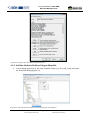
1
URBAN SMS Soil Management Strategy Tools and data description manual Web application URBAN SMS suite January, 2012 Interreg CENTRAL Urban SMS WP4 Soil Manager Suite. Tool&Data Description Urban SMS WP4 Soil Manager Suite Task 4.3.1: Final version of the desktop computer application Task 4.3.3: Final version of the web based evaluation system Deliverable: Final version of tool description Web Soil Management Tool Urban SMS Tools Description & Functioning • • • • • • Urban SMS tools Goals, semantics and functioning Data description Equations Legends Interpretations Version: Final version Saved: Friday, January 27, 2012, Printed: Sunday, 29 January 2012 File:K:\CTO\08UrbanSMS\UrbanSMS_ToolDevelopment\Manuals‐Beta08\UrbanSMS.WP4.Tools&DataDescription.23avgC.docx Page: 1 / 58 Saved: Friday, January 27, 2012, Printed: Sunday, 29 January 2012 Interreg CENTRAL Urban SMS WP4 Soil Manager Suite About a task Project Urban SMS http://www.urban‐sms.eu WP4 Soil Manager Suite WP responsible: dr. Borut Vrščaj, Agricultural Institute of Slovenia, Hacquetova ulica 17, SI1000 Ljubljana, Slovenia Tool development ‐ final version: Doc. Dr. Borut Vrščaj, univ.dipl.ing. Mag. Tomaž Vernik, univ.dipl.ing. Marjan Šinkovec, univ.dipl.ing.geol. Janez Bergant, univ. dipl. geog. with contributions from; Marco Parolin, City of Milan Fabio Villa, City of Milan Dr. Mattia Biasioli, University of Turin, DiVAPRA Contact: [email protected] Page: 3 / 58 Saved: Friday, January 27, 2012, Printed: Sunday, 29 January 2012 Interreg CENTRAL Urban SMS WP4 Soil Manager Suite About a document The document presents detail descriptions and semantics of tool functionalities that were designed and developed in close collaboration with project partners. Document stage: Final version, December 2011 Authors: Doc. Dr. Borut Vrščaj, univ.dipl.ing.agr Tomaž Vernik, univ.dipl.ing.agr Marjan Šinkovec, univ.dipl.ing.geolog. Janez Bergant, univ. dipl. geog. Fabio Villa, City of Milan Marco Parolin, City of Milan Dr. Mattia Biasioli, University of Turin, DiVAPRA Contact: [email protected] Abstract According to the project partners selection process the following tools were selected for WP4 development: 1. Ecosystem Soil Quality (ESQ) 2. Loss of soil resource (LSR) 3. Soil contamination (SC) redesigned, now divided to: o General agriculture (SCFood) o Children's playground areas (SCPlay) and o Recreational areas (SCSport) 4. Sealing rate (SR) 5. Agricultural Soil Quality (ASQ) 6. Water drainage (WD) On a later stage two were proposed by the City of Milano 7. Connectivity tool (CNT) 8. Proximity tool (PROX) Additional tools were developed in order to ensure adequate input data for the main tools: 9. Nutrient Status tool Page: 5 / 58 Saved: Friday, January 27, 2012, Printed: Sunday, 29 January 2012 Interreg CENTRAL Urban SMS WP4 Soil Manager Suite Content Urban SMS .............................................................................................................................................................. 1 WP4 Soil Manager Suite ......................................................................................................................................... 1 Task 4.3.1: Draft version of the desktop computer application............................................................................. 1 Task 4.3.3: Draft version of the web ‐based evaluation system ............................................................................ 1 Web Soil Management Tool ................................................................................................................................... 1 Urban SMS Tools ‐ Description & Functioning ....................................................................................................... 1 About a task............................................................................................................................................................ 3 About a document.................................................................................................................................................. 5 Abstract .................................................................................................................................................................. 5 Content................................................................................................................................................................... 7 1 Urban SMS tools ............................................................................................................................................. 9 1.1 List of the Urban SMS tools .................................................................................................................... 9 1.1.1 Main tools....................................................................................................................................... 9 1.1.2 Secondary tools ............................................................................................................................ 10 2 Scope of analysis (area selection) ................................................................................................................ 11 2.1 Range of Municipality Area (MA) ......................................................................................................... 11 2.2 Range of Analysis Area (AA) ................................................................................................................. 11 2.2.1 AA Selection.................................................................................................................................. 11 3 10 steps for effective definition of the tool ................................................................................................. 12 3.1 I. Input data definition.......................................................................................................................... 12 3.2 II. Tool algorithm .................................................................................................................................. 12 3.3 III. Testing the equation and output range........................................................................................... 13 3.4 IV. Definition of classes, class names, instructions .............................................................................. 13 3.5 Fine‐tuning of the tool and best practices ........................................................................................... 13 4 Description of main Urban SMS tools .......................................................................................................... 19 4.1 Ecosystem soil quality (ESQ)................................................................................................................. 19 4.1.1 The purpose of the ESQ tool......................................................................................................... 19 4.1.2 ESQ data preparation ................................................................................................................... 19 4.1.3 ESQ calculation ............................................................................................................................. 19 4.1.4 Outputs ......................................................................................................................................... 20 4.1.5 Functional step‐by‐step description of ESQ tool.......................................................................... 20 4.1.6 ESQ algorithms ............................................................................................................................. 20 4.1.7 Example of the ESQ calculation .................................................................................................... 21 4.1.8 Reclassification and interpretation of the ESQ grid ..................................................................... 22 4.2 Loss of soil resource (LSR) .................................................................................................................... 23 4.2.1 The purpose of the LSR tool ......................................................................................................... 23 4.2.2 LSR data preparation .................................................................................................................... 24 4.2.3 Outputs ......................................................................................................................................... 24 4.2.4 Functional step‐by‐step description of LSR Tool .......................................................................... 25 4.2.5 LSR algorithms .............................................................................................................................. 25 4.2.6 Example of the LSR calculation..................................................................................................... 25 4.2.7 Reclassification and interpretation of the LSR ............................................................................. 26 4.2.8 Interpretation of the LSR index .................................................................................................... 26 Page: 7 / 58 Saved: Friday, January 27, 2012, Printed: Sunday, 29 January 2012 Interreg CENTRAL Urban SMS WP4 Soil Manager Suite 4.3 Soil Contamination (SC) ........................................................................................................................ 27 4.3.1 The purpose of the SC tools ......................................................................................................... 27 4.3.2 SC data preparation...................................................................................................................... 27 4.3.3 Modifications of SC according to the land use ............................................................................. 28 4.3.4 SC calculation................................................................................................................................ 29 4.3.5 Outputs ......................................................................................................................................... 29 4.3.6 Functional step‐by‐step description of the SC tool ...................................................................... 29 4.3.7 SC algorithm ................................................................................................................................. 30 4.3.8 Example of the SC calculation ...................................................................................................... 30 4.3.9 Reclassification and interpretation of the SC grid........................................................................ 31 4.3.10 Interpretation of the SC results .................................................................................................... 31 4.4 Sealing Rate (SR) ................................................................................................................................... 33 4.4.1 The purpose of the SR tool ........................................................................................................... 33 4.4.2 Spatial extent: AA ......................................................................................................................... 33 4.4.3 Data requirements........................................................................................................................ 33 4.4.4 Outputs ......................................................................................................................................... 33 4.4.5 Functional step‐by‐step description............................................................................................. 34 4.4.6 SR interpretation .......................................................................................................................... 35 4.5 Agricultural Soil Quality (ASQ).............................................................................................................. 36 The purpose of the ASQ tool ........................................................................................................ 36 4.5.1 4.5.2 Data requirements........................................................................................................................ 36 4.5.3 Outputs ......................................................................................................................................... 36 4.5.4 Preparation of measured data for ASQ tool calculations............................................................. 37 4.5.5 Functional step‐by‐step description of ASQ tool.......................................................................... 37 4.5.6 ASQ algorithms ............................................................................................................................. 38 4.5.7 Reclassification of the ASQ grid.................................................................................................... 40 4.6 Water drainage (WD) ........................................................................................................................... 41 4.6.1 The result of the WD tool ............................................................................................................. 41 4.6.2 Data requirements........................................................................................................................ 41 4.6.3 Outputs ......................................................................................................................................... 41 4.6.4 Functional step‐by‐step description of WD tool .......................................................................... 41 4.6.5 WD algorithms.............................................................................................................................. 42 4.6.6 Example of the WD calculation .................................................................................................... 43 4.6.7 Reclassification and interpretation of the WD grid...................................................................... 43 4.7 Connectivity tool (CNT)......................................................................................................................... 45 4.7.1 The purpose of the CNT tool ........................................................................................................ 45 4.7.2 Spatial extent................................................................................................................................ 45 4.7.3 Data requirements........................................................................................................................ 45 4.7.4 Outputs ......................................................................................................................................... 46 4.7.5 Functional step‐by‐step description of CNT tool.......................................................................... 46 4.7.6 The CNT tool output ..................................................................................................................... 48 4.8 Proximity tool (PROX) ........................................................................................................................... 50 4.8.1 The purpose of the PROX tool ...................................................................................................... 50 4.8.2 Spatial extent................................................................................................................................ 50 4.8.3 Data requirements........................................................................................................................ 50 Page: 8 / 58 Saved: Friday, January 27, 2012, Printed: Sunday, 29 January 2012 Interreg CENTRAL Urban SMS WP4 Soil Manager Suite 4.8.4 Outputs ......................................................................................................................................... 52 4.8.5 Functional step‐by‐step description of PROX tool ....................................................................... 52 4.8.6 The PROX tool output................................................................................................................... 53 5 Description of the secondary Urban SMS tools............................................................................................ 55 5.1 Nutrient Status (NS).............................................................................................................................. 55 5.1.1 The purpose of the NS tool........................................................................................................... 55 5.1.2 NS calculation ............................................................................................................................... 55 5.1.3 NS algorithm ................................................................................................................................. 55 5.1.4 Example of the NS calculation ...................................................................................................... 55 5.1.5 Reclassification and interpretation of the NS grid ....................................................................... 56 6 Evaluation parameters and data description ............................................................................................... 57 6.1 Common Data Description Table (DDT) ............................................................................................... 57 1 Urban SMS tools This document presents the semantics and functional description of Urban SMS tools ‐ integral part of the Urban SMS web system. It represents beta version of the Urban SMS web tool development which is according to the project plan in lines with the mid of the project time schedule. The content of this document is temporary functional model of tools which is scheduled to be test implemented, commented and improved and by project partners within WP5. System will be finalised by the WP4 team in the last stage of the project. 1.1 List of the Urban SMS tools 1.1.1 Main tools According to the project partners selection process the following tools were selected for WP4 development: 10. Ecosystem soil quality (ESQ) (5 implementations) 11. Loss of soil resource (6 implementations) 12. Soil contamination (SC) (4 implementations) redesigned, now including o general agriculture areas (SCFood) (2 implementations) and o children's playground areas (SCPlay) (2 implementations) and o recreational areas (SCSport) (1 implementation) 13. Sealing rate (SR) (4 implementations) 14. Agricultural soil quality (ASQ) (4 implementations) 15. Water drainage (1 implementation) Plus the tools additionally proposed by the City of Milano 16. Connectivity tool (2 implementations) 17. Proximity tool (2 implementations) Page: 9 / 58 Saved: Friday, January 27, 2012, Printed: Sunday, 29 January 2012 Interreg CENTRAL Urban SMS WP4 Soil Manager Suite These two tools are still in the development stage due to the later start. 1.1.2 Secondary tools Additional tools are developed as integral part of main tools in order to ensure adequate input data for the main tools. 1. Nutrient Status tool (as input required for ASQ, ESQ tools) Page: 10 / 58 Saved: Friday, January 27, 2012, Printed: Sunday, 29 January 2012 Interreg CENTRAL Urban SMS WP4 Soil Manager Suite 2 Scope of analysis (area selection) All Urban SMS tools perform its evaluation within predefined area (area selected by the user) which can be either • The whole city area / range of municipality (MA) or • Selected smaller planning areas ‐ areas of analysis (AA) 2.1 Range of Municipality Area (MA) As a default setting several soils information covers entire territory of local community / region / city/ county / municipality (further in text municipality or MA).The entire territory in general equals the municipality area covered with all datasets. When no separate polygons of areas (e.g. planning cases) are selected, each tool evaluates the parameters for the entire MA area. Evaluation is only possible when/if all required data layers are available. In case that a part of data in separate layer is missing tool recognizes this part as No data area. When any of required layers is not available, the analysis cannot be performed or alternatively. 2.2 Range of Analysis Area (AA) Analysis area (AA) is smaller area (usually the planning case or soil management area) within the MA, typically closed area with specific planned land use. Different AAs usually represent different planning areas ‐ planning cases within municipality spatial planning acts. Each AA represents separate development area in form of a closed polygon. Tolls perform data evaluation within one or more polygons which have to be preselected on screen using Custom areas set of tools. The result of evaluation, a summary and statistical analysis are separately presented / listed according to AA selected. 2.2.1 AA Selection AA selection is an independent step, which can be repeated for multiple selections. By selection of particular area, user spatially defines the area on which the tool evaluation will be performed. In this way user can evaluate different planning scenarios. AA polygons are selected using Custom areas set of tools. On or several AA polygons can be selected from: • An existing polygon layer (Å poly data from other sources, e.g. planning departments; Land use, Cadastral data) • User defines new, custom polygon (On‐screen digitized polygons & stored as a poly layer Å technical tool) Tools which are designed to operate with special datasets (e.g. LSR tools requires planning area polygons with predefined structure) prompt the user to upload required datasets. Page: 11 / 58 Saved: Friday, January 27, 2012, Printed: Sunday, 29 January 2012 Interreg CENTRAL Urban SMS WP4 Soil Manager Suite 3 10 steps for effective definition of the tool Please see below a screenshot of a typical Admin page with indicated numbers for steps explained in further text. Admin page is structured from 3 main categories; 1. Input data definition, 2. Tool algorithm, and 3. Data interpretation and legend Each serves for defining tool results according to user needs. 3.1 I. Input data definition Describes the data used for calculation; its name (1), path (2) or location where it is stored and importance or weight (3): 1. Data name in Maestro. • Input layer should be named according to good practice (see the Data preparation manual) eg: i. gAA_XXX; where g is abbreviation for ESRI grid GIS layer; ii. AA : is the content (e.g. PH); iii. XXX : stands for tool name abbreviation ; e.g. ESQ. • Example for output layer name; gESQ_result. 2. Data path • Locates the data layer in the local file system. • Please note that ESRI grids are folders containing several files. Show hdr.adf file in the grid folder. 3. Weight for each input grid. • 1 = less significant; 2: normal significance, 3: very significant. • result weight = 0 3.2 II. Tool algorithm Algorithm defines the relation between the input information (layers) combining it into mathematical equation. PLESE NOTE: in order to process these information successfully, Grass specific mathematical operations (commands) must be used. Also see the Grass r.mapcalc user manual ‐ http://grass.fbk.eu/gdp/html_grass64/r.mapcalc.html ). The calculation can be performed in several steps. The whole calculation (all steps) are performed in one go. 4. Describe the name of the step of the equation (description is only for your record and it doesn’t impact the algorithm) 5. Define the equation • We suggest you to use initial equation but which can be adapted to your local data / legislation/ evaluation practices.... • additional GRASS function can also be embedded (see. r.mapcalc manual) • See the example for ESQ tool: Function float(<expression>) converts the integer grid to real number grid (decimal values) where <exprwession> stand for grid (e.g. Page: 12 / 58 Saved: Friday, January 27, 2012, Printed: Sunday, 29 January 2012 Interreg CENTRAL Urban SMS WP4 Soil Manager Suite gAbsESQ) or mathematical expression (e.g. gAbsESQ/3*100 ). Please also see additional explanation. There seems to be a common misconception that ADMIN page settings (number of classes and class description etc) are defined according to the input data rasters. This is not the case. All settings are defining the results calculated within each tool. 3.3 III. Testing the equation and output range To be able to set the class values and definition of each class, you need to know the value span of your results! PLEASE NOTE! The ‘SAVE AND TEST’ button incorporated under the ‘Tool algorithms’, enables the Administrator to test the tool result before they are displayed on the map. This function shows the range of your result calculated (Min and Max) and enables you to define the classes accordingly. This function is enabled for every tool. Save and test operation • Click save and test Æ if your algorithm is mathematically correct and the syntax follows the r.mapcalc you should get a message: i. Successfully saved and tested! ii. A range of the output values is presented (min. and max. value of the output grid) • If your algorithm is mathematically false, this will be displayed and you should correct the algorithm. • This step must be completed with range values. 3.4 IV. Definition of classes, class names, instructions Prior of using the system, the class names, range and descriptions should be defined. 6. Class ranges • Define up to 10 classes for the range values • Where applicable, apply your local legislation or best practice guides to set the classes. 7. Define Class description • Enter short name of the class. Please note that class name appears in the final report. 8. Define class colours • Again follow the good practice, use grading colours 9. Define interpretation of the class • This is a key step for final outcome of the system! Interpretation of each class is meant to be an intuitive text which serves as an instruction to steer the planner/decision maker making a final decision. 3.5 Finetuning of the tool and best practices In order to fine‐tune your system it is advisable to play with different scenarios, evaluating the results the system produces: Page: 13 / 58 Saved: Friday, January 27, 2012, Printed: Sunday, 29 January 2012 Interreg CENTRAL Urban SMS WP4 Soil Manager Suite • It is highly advisable to convert the output grid to integer using the Grass r.mapcalc functions. On the case of the ESQ tool this was incorporated in 3 step equation: float(AbsESQ/MaxESQ)+100 • Play with weights: change the weights, other integer number can also be used (e.g. 1, 2, 3, 4, 5 where 1‐ very low importance, 2‐ low importance, 3‐ neutral importance, ... 5‐ highly important) In case all input grids are integer the output of the equation 5 is integer grid. Depending on the equation the resulting decimal places may be truncated. If any of input grids is real value grid, the output is real value grid. Function float() forces the output raster to be converted to the real number value raster GIS layer Æ bigger diversity of values which enables larger number of classes. Page: 14 / 58 Saved: Friday, January 27, 2012, Printed: Sunday, 29 January 2012 Interreg CENTRAL Urban SMS WP4 Soil Manager Suite Page: 15 / 58 Saved: Friday, January 27, 2012, Printed: Sunday, 29 January 2012 Interreg CENTRAL Urban SMS WP4 Soil Manager Suite I. 1 3 II. 4 5 III. IV. 2 6 7 8 9 10 Figure 1: Example of a typical Admin page with indicated numbers for steps explained in previous text. Page: 17 / 58 Saved: Friday, January 27, 2012, Printed: Sunday, 29 January 2012 Interreg CENTRAL Urban SMS WP4 Soil Manager Suite Page: 18 / 58 Saved: Friday, January 27, 2012, Printed: Sunday, 29 January 2012 Interreg CENTRAL Urban SMS WP4 Soil Manager Suite 4 Description of main Urban SMS tools 4.1 Ecosystem soil quality (ESQ) Planned implementation by the PPs: Prague, Vienna, Pulawy, Celje and Milan. ESQ reflects the capacity of soil to perform the most important soil functions in terrestrial ecosystem regardless the land use (agricultural, forestry, parks...). It reflects the multifunctional role of soils in one index. ESQ stands for the quality of soil in its broadest sense. Relevant soil quality parameters are evaluated to assess the capacity of soil to perform main environmental functions: • • • Filtering & buffering of various substances and water; Biomass (food & fibre) production; Carbon sequestration; An additional parameter for the ESQ evaluation: • Soil contamination. The ESQ is evaluated using separate measured or estimated soil properties which are widely available and recognisable as the main source of soil data. In some countries ESQ can also stand for the general agricultural soil quality (ESQ).1 4.1.1 The purpose of the ESQ tool To elaborate the ESQ raster database for the entire MA. ESQ tool is applied on the entire municipality territory or areas where adequate soil data is available. 4.1.2 ESQ data preparation Soil measured data linked to the soil map of appropriate scale are converted into a quality class values by local soil expert using local threshold values. When the class data is already available this step is not necessary. In the preparation stage vector polygons are rasterised using simple vector to raster GIS tool. The threshold values for the ESQ tool have to be used. The system offers required flexibility for municipalities to set their own threshold values according to their national legislation, own practices, data availability, data situation. This step is important step and carried out in the data preparation phase or repeated when data is replaced with new set. The threshold values should be set by the soil expert. 4.1.3 ESQ calculation The ESQ index is calculated using elaborated relative SQI which is selected from the Basic/Environmental SQI and set by applying the ESQ equation (in development). In this manual the ESQ is calculated using relevant and most generally available soil quality indicators (SQI) expressed in classes. These are multipurpose and in already acquired. 1 Soil quality information is in some countries already available (e.g. maps of agricultural soil quality) and is obliged to be used. In such cases the use of ESQ tool can be skipped or it can be used to elaborate additional ‐ ecosystem related soil quality information. Page: 19 / 58 Saved: Friday, January 27, 2012, Printed: Sunday, 29 January 2012 Interreg CENTRAL Urban SMS WP4 Soil Manager Suite The ESQ function requires weights for each parameter. The values are predefined and can be changed /adapted according to country’s practise/legislation. Weights: 1 ‐ less important; 2 ‐ normal importance; 3 ‐ very important. See the following table as an example of the ponder values. Table 1: ESQ data list (part of the common Data Description Table ‐DDT) Tool ESQ ESQ ESQ ESQ ESQ ESQ Dataset Weight Units DataName gOM_ESQ 3 Class Soil organic matter content class ‐ topsoil gPH_ESQ 2 Class Soil pH class ‐ topsoil gSD_ESQ 2 Class Soil depth (or rootable depth) gTX_ESQ 2 Class Soil texture class gSCFood_result 3 Class Soil contamination class gNS_result 3 Class Nutrient status class FileName gOM_ESQ gPH_ESQ gSD_ESQ gTX_ESQ gSCFood_result_ESQ gNS_result_ESQ Topology cell cell cell cell cell cell Format ESRI grid ESRI grid ESRI grid ESRI grid ESRI grid ESRI grid ESQ index quantifies the environmental soil quality and the capacity of the soil to perform primary environmental functions in one number. 4.1.4 Outputs Outputs are: • ESQ map for: presentation of soil potentials and the ecosystem quality for the MA soil resource or within AA. • PDF report o Small map of the MA or AA section (visualisation of the evaluation results) o Statistics and the ESQ distribution (distribution of the ESQ index / ha) o Matrix (ESQ values, ha) The outputs give interpretation of the results distinguishing between “good” and “bad” soil of the area and basic guidelines for planning / soil management activities. ESQ can be as input information for other tools (e.g. sealing): prevention of wasting the soil resource by directing the development to low ESQ areas. 4.1.5 Functional stepbystep description of ESQ tool2 • • Run/execution of the ESQ tool (see left ‐ tool section of the Urban SMS web page) Background processing o o o • Checking of the availability of soil data (required SQI grids) Processing of the predefined ESQ equation (see Admin section of the Urban SMS web page) Elaboration of the report (statistics of the soil quality of the area) Presentation of results o o Visualisation / mapping of the grid on the screen for MA / AA area Presentation of the ESQ report (pdf ‐‐> system functions Print & Save) 4.1.6 ESQ algorithms ESQ calculation is carried out in three steps. These can be arranged as separate equations with the intermediate grids/results that are deleted immediately by the tool itself (no intermediate results saved). The value of each class is multiplied by the weight DDT.Tool = ESQ.Weight (table = DDT; Tool = ESQ, weight = Weight value of the cell). 2 For details also see the Urban SMS Web User Manual Page: 20 / 58 Saved: Friday, January 27, 2012, Printed: Sunday, 29 January 2012 Interreg CENTRAL Urban SMS WP4 Soil Manager Suite Where weights are: 1‐low impact/less important to the 3‐high impact/importance). The product of all parameters is joined to obtain an absolute estimate ESQ (abs.ESQ). AbsESQ = “((gOM_ESQ*wgOM_ESQ) + (gPH_ESQ*wgPH_ESQ) + (gNS_result*wgNS_result_ESQ) + (gTX_ESQ*wgTX_ESQ) + (gSD_ESQ*wgSD_ESQ) + (gSCFood_result*wgSCFood_result_ESQ))” Eq. 1 Where: gXX are separate SQI grids where call values are quality class values; see Table 1, :DDT, field Dataset wXX are separate weights for corresponding SQI grids Max.ESQ is calculated by summing all parameter products, where each parameter takes the highest possible rating class 5 (Class column). MaxESQ = “7 * (wgOM_ESQ + wgTX_ESQ + wgNS_result_ESQ + wgPH_ESQ + wgSD_ESQ + wgSCFood_result_ESQ)” Eq. 2 Where: wXX are separate weights for corresponding SQI grids 5 = max value of class The average class ESQ is calculated by dividing the absolute ESQ (abs.ESQ) by the sum of the weights. The relative assessment of ESQ (RelESQ) is calculated by dividing the parts of absolute evaluation ESQ (AbsESQ) and the potential assessment ESQ (MaxESQ). Eq. 3 RelESQ: AbsESQ/MaxESQ *100 In the next step the interpretation of results follows (RelESQ and ESQ class). 4.1.6.1 Resulting GIS layers gESQr = RelESQ ‐ Ecosystem soil quality expressed in % gESQc = gESQ_result ‐ Ecosystem soil quality expressed as class (1 worst ‐5 best) 4.1.7 Example of the ESQ calculation As presented in table below there is a graphical example of the ESQ calculation steps. Table is divided on input data (presented as grid names), corresponding weights, intermediate and final results. Result of the tool is presented as an index. The ESQ value (gESQr) is relative index which is in the next (final) step classified (ESQ class ‐ gESQc) and interpreted using the ESQ reclassifications table (see below). Page: 21 / 58 Saved: Friday, January 27, 2012, Printed: Sunday, 29 January 2012 Interreg CENTRAL Urban SMS WP4 Soil Manager Suite Table 2: ASQ input information required by the ASQ algorithm. Parameter Data Layer Quality Indicator No. 1 gOM Soil organic matter content class ‐ topsoil 2 gpH Soil pH class ‐ topsoil 3 gSD Soil depth (or rootable depth) 4 gTX Soil texture class 5 gSC Soil contamination class 6 gNS Nutrient status class Sum of weighted values 20,0 Maximum possible class 30,0 ESQ value (%) ESQ Class Class Description Medium quality soil Units Class Class Class Class Class Class Data Value 3 4 3 4 3 3 Weight 3 2 2 2 3 3 Weighte d Value 4,5 4 3 4 4,5 4,5 66,7 6 Class Interpretation Land of good ecosystem value. Sealing is to be avoided. Soil to be preserved to perform the ecosystem functions. 4.1.8 Reclassification and interpretation of the ESQ grid 4.1.8.1 An example of the ESQ reclassification table Table 3: An example of the ESQ reclassification table Class Min Max 1 1 20 2 21 40 3 41 60 4 61 80 5 81 85 6 7 86 91 90 100 Class description Marginal or no soil ecosystem quality Low quality soil Low to medium quality soil Medium quality soil Good soil Very good soil High capacity soil Color Interpretation No ecosystem value land. Suitable for urban expansion. In case of soil #EEE8CD contamination, reconsider the urban land use and / or take remediation actions. Marginal ecosystem value land. Changes to urban land use recommendable. #E3CF57 #EEEE00 #CAFF70 #66CD00 #458B00 #008B45 Land of medium ecosystem value. Sealing should be avoided. Other green urban land uses recommendable. Land of good ecosystem value. Sealing is to be avoided. Soil to be preserved to perform the ecosystem functions. Land of best ecosystem value land. No sealing. Soil to be protected to perform the ecosystem functions. Very ecosystem important land. Best capacity land within the area. Need to be protected. Sealing avoided. The upper rating can be modified to meet specific conditions and/or needs. Up to 10 classes can be used for reclassification and interpretation. 4.1.8.2 Interpretation of the ESQ index The ESQ equation yields values in a range from 0 to 100. The SEQ values are used for a qualitative description of the ecosystem soil quality and to quantify the terms for good and bad soil. The higher the ESQ class or the ESQ value the better the soil performs the ecosystem functions. High ESQ valued soils represent the best soil resource. It is recommendable to preserve soil with high ESQ class / value as natural, semi‐natural and agricultural land use. In urban planning and management it is recommendable to avoid soil degradation (erosion) or soil destruction (i.e. sealing) on land with high(er) ESQ value. The lower the ESQ value, the more is land suitable for other land uses (i.e. housing, infrastructure...). Medium ESQ value land should be considered for less destructive land uses where soil services are still preserved (i.e. urban green areas). Usually this is the matter of municipality spatial planning policies and specific / local needs. Page: 22 / 58 Saved: Friday, January 27, 2012, Printed: Sunday, 29 January 2012 Interreg CENTRAL Urban SMS WP4 Soil Manager Suite 4.2 Loss of soil resource (LSR) LSR tool is planned to be implemented by: Stuttgart, Prague, Vienna, Pulawy, Bratislava, Celje. LSR tool estimates the loss of soil resource when the land use is changed and assesses the impact of land use change. The soil resource is totally or partly lost in case of: • soil damage (significant part of top soil removed, topsoil extremely and long‐term contaminated, severely eroded, etc) • total soil destruction: (when the soil is sealed with impermeable layer, soil permanently removed, totally eroded, etc.) In general, the soil is lost / sealed during the construction of housing, industry, infrastructure, etc. Soil resource can be also improved by soil remediation / reclamation or change to land use which causes topsoil (or entire soil profile) improvements: e.g. change of industrial sites / brown fields to ornamental gardens, intensive arable land to grasslands, etc. 4.2.1 The purpose of the LSR tool The purpose is to evaluate the impact of the planned land use change on soil resource. Evaluation is carried out in quantitative and qualitative way using the index calculation system. LSR tool is used for evaluation of sealing impacts and complies with the loss of soil resource assessment; • The impact is negative when soils are sealed3. The extent of the potentially sealed area is compared to the soil quality4, evaluated according the algorithm and finally expressed in form of an index / score for each planning area and soil quality within the AA. • The result of each evaluation is a PDF based report with: o graphical presentation of the area/results showing the distribution of soil quality vs. area o statistical figures o the impact index ‐ difference in soil resource score between present and planned scenario The tool is designed to be repeatedly run on different AAs ‐ planning scenarios. The results of each assessment can be compared and used for argumentation/support in decision making process which should reflect the lowest impact on soil resource. The outputs/results of the LSR evaluations are used to compare different scenarios and their impact on soil quantity / quality and to mitigate the effects of soil sealing. 3 It can be also positive in case of soil remediation or land change when the soil capacity is improved (i.e. land use is changed previously sealed/degraded area is planned to be revitalised/remediated). This option of the tool is still explored. 4 ESQ or ASQ, depending on the data availability and binding legislation / procedures Page: 23 / 58 Saved: Friday, January 27, 2012, Printed: Sunday, 29 January 2012 Interreg CENTRAL Urban SMS WP4 Soil Manager Suite 4.2.2 LSR data preparation vPA is the vector shape file usually provided by planning departments. It contains one or more planning areas (PA), each composed of one or more polygons with different planned land uses Æ each can be with different rate of sealing. Main vPA attributes are actual and planned sealing degrees; E.g. actual surface of sealed soil for a building, parking place, park etc. Rates of sealing differ. Table 4: LSR input information required by the LSR algorithm The tool analysis area is AA specific. Planning scenarios must be imported as AA polygons in shp file. Shape file must hold a predefined structure and information: • Internal polygons with different degree of sealing (for different type of sealing: building 100% , paved parking lot 75%, park 15%, etc...) for each land use within the area of land use change. • Planned sealing rate (sealing degree) % • Contamination information (optional) • Archive/ cultural / natural (optional) Required fields in the vAA shape file are shown in the table bellow. Table 5: An example of required fields in vAA shape file. Field Name PA_ID SealedE LandUseE SealedP LandUseP Field Description Planning area ID Degrees of sealed soil under existing/ present land use Present / existing land use description Degrees of sealed soil under planned land use Planned land use description Type number number Character number Character Units Example number 3 % 15 character grassland % 70 character building Caution: mandatory fields: • numeric SealedE, SealedP are required for calculations • character field LandUseP for label in map (Maestro label definition) 4.2.3 Outputs • • Map: Impact of land use change on soil resource within vPA after different land use scenarios. Expressed as an index (BXI) Pdf report: o Map of the vPA (or same view as set onscreen before the analysis) o Distribution graph of class area values o Matrices separately presenting statistical data for : - gBXE Existing (before the land use change) (quantitative and qualitative) for each AA - gBXP Planned (after the land use change/sealing) for each AA - gBXI Impact or evaluation result (soil loss / gain?) in index points - Impact result (soil loss / gain?) in percent (%) Page: 24 / 58 Saved: Friday, January 27, 2012, Printed: Sunday, 29 January 2012 Interreg CENTRAL Urban SMS WP4 Soil Manager Suite 4.2.4 Functional stepbystep description of LSR Tool5 • • The vPA shp file must be uploaded using the Custom areas set of tools. User browses and uploads the appropriate shp file from the local disk (if not already uploaded, check the vPA layer under LSR tool) Execution of the LSR tool. o o o • Background processing: o o o • selection of the vPA from the list of available layers zoom to the vPA area selection of desired polygons on screen Rasterisation of existing sealing ‐ vPA using the SealedE to gSealE Rasterisation of planned sealing ‐ vPA using the SealedP to gSealP Processing LSR algorithms / function Elaboration of Pdf report o o o Map of the area Distribution of gBXi 3 x matrix elaborating gBXE, gBXP, gBXi and Impact (%) 4.2.5 LSR algorithms LSR calculation is carried out in four steps (equations). In first step the agricultural input soil quality grid (gAQS) is first multiplied by present sealing rate (BXE) to calculate present soil quality points (gBXE) and second by planned sealing (BXP) to calculate /estimate soil quality points after land use change (gBXP). In the third step the impact of land use change (BXI) is elaborated as a difference between BXE and BXP. The last step is to assess the impact of land use change in percent. Eq. 4 gBXE.LSR = gASQ_result * (100 ‐ gSealE)/100)*25 Where: gBXE = present soil points gQS = soil quality grid; gSealN is existing sealing rate. Eq. 5 gBXP.LSR = gASQ_result * (100 ‐ gSealP)/100)*25 Where: gBXE = present soil points gQS = soil quality grid; gSealP is planned sealing rate. Eq. 6 gBXI.LSR = gBXP ‐ gBXE Where: gBXI is assessed impact of land use change. Eq. 7 Impact = (gBXI / gBXE) * 100 Where: Impact is assessed impact of land use change in percent %. 4.2.6 Example of the LSR calculation As presented in table below there is a graphical example of the LSR calculation steps. Table is divided on input data (presented as grid names), corresponding weights, intermediate and final results. Result of the tool is presented as an index. The LSR value is relative index which is in the next (final) step classified (LSR class) and interpreted using the LSR reclassifications table (see below). 5 For details also see the Urban SMS Web User Manual Page: 25 / 58 Saved: Friday, January 27, 2012, Printed: Sunday, 29 January 2012 Interreg CENTRAL Urban SMS WP4 Soil Manager Suite Table 6: An example of LSR calculation. Planning Area Sections 1 2 3 4 5 6 7 8 9 10 Land Use of the section Buildings Parking lot Ways Allotment gardens Area of section (ha) 3,50 1,50 1,00 0,30 Sum 6,30 Diff: 6,30 Sealed (%) Soil Quality 0 90 90 45 0 0 0 0 0 0 4,5 1 1 2 0 0 0 0 0 0 Soil Planned Soil quality Quality Soil Loss Sealing area (Bx) Sealed (Bx) (%) (Bx) 90 15,75 1,58 14,18 90 1,50 0,15 1,35 95 1,00 0,05 0,95 45 0,60 0,33 0,27 0 0,00 0,00 0,00 0 0,00 0,00 0,00 0 0,00 0,00 0,00 0 0,00 0,00 0,00 0 0,00 0,00 0,00 0 0,00 0,00 0,00 18,85 2,11 16,75 Initial Bx Sealed Bx Soil Loss (Bx) Soil Loss (%) 18,85 2,105 16,7 88,8 4.2.7 Reclassification and interpretation of the LSR Table 7: An example of LSR reclassification table. The upper rating can be modified to meet specific conditions and/or needs. Up to 10 classes can be used for reclassification and interpretation. 4.2.8 Interpretation of the LSR index As stressed before the LSR tool assesses the difference/change between the current and future/planned land use scenarios, expressing its result as an index. The result of the calculations is first classified, each class being interpreted accordingly: • negative BXI (BXI < 0): the soil points under planned land use are lower than under present land use Æ some of soil resource is lost / damaged. • BXI equals or close to 0: no significant impact of planned land use on the soil resource. • positive BXI: the soil points under planned land use are bigger than under present land use Æ soil resource is improved. Page: 26 / 58 Saved: Friday, January 27, 2012, Printed: Sunday, 29 January 2012 Interreg CENTRAL Urban SMS WP4 Soil Manager Suite 4.3 Soil Contamination (SC) The soil contamination (SC) tool features three tools ‐ three soil contamination evaluations for three different land uses: 1. General (agricultural) soil contamination (SCFood) 2. Children playgrounds soil contamination (SCPlay) 3. Sporting areas soil contamination (SCSport) The semantic/calculation/design is the same for all three tools, with a difference that they assess soil contamination according the threshold values of the separate land use: 1. Threshold values for general (agricultural) soil contamination (to be implemented by the PPs; Bratislava, Vienna, Pulawy and Celje) 2. Threshold values for contamination of the children playground areas (to be implemented by the PPs; Pulawy, Bratislava) 3. Threshold values for soil contamination for recreational areas (to be implemented by Pulawy) In general, all SC tools evaluate soil contamination according to the national threshold values for selected land use. Threshold values for each SC tool are pre‐defined in the Urban SMS web page, Admin section, Edit Input Data Soil Contamination table. 4.3.1 The purpose of the SC tools The purpose is to elaborate information (map) on legal status of contamination and/or suitability of assessed land for selected area (AA). Contamination raster files (measured data) are compared to the national legislation (threshold values according to land use) by separate contaminant and classified. The output is “summarized” contamination information in form of a single number, which represents the number of contaminants exceeding the threshold values. The tool elaborates the map with contaminated areas on MA or AA scale and generates report. 4.3.2 SC data preparation For SC assessment contamination grid layers are used. Data can be prepared using two different approaches according to the accuracy, data density and spatial variability of contamination (contamination sources): 1. Geo‐statistical methods (i.e. kriging, IDW, ...), gives the scientific approach to statistical spatial approximation of the soil contamination and does not give the actual measured contamination. OR: 2. Simple point to raster conversions in GIS represents a simple transformation from vector point information to raster point information. The result is actually measured contamination as it was determined by sampling and analytics. Big lack of information bit accurate information supported by the measured values. Approach should selected according to the internal municipal data preparation and assessment policy. Page: 27 / 58 Saved: Friday, January 27, 2012, Printed: Sunday, 29 January 2012 Interreg CENTRAL Urban SMS WP4 Soil Manager Suite 4.3.2.1 Geo-statistical approach The input information required by the tool is raster contamination GIS layer generated from point contamination data. Point information is geo‐statistically processed using geostatistical spatial interpolation to assess the contamination between individual sampling points (measured data). The result is spatial approximation of the contamination in a raster form. Grids are elaborated (by experts) for separate contaminants. 4.3.3 Modifications of SC according to the land use As described above, SC tool was multiplied to enable the area assessments according to planned scenarios (land use). With multiplication all functionalities of the tool remained the same. The grid soil contamination status is elaborated with the same semantics using three different sets of threshold values. 4.3.3.1 SCFood Figure 2: Example of admin edit input data table for General (Agricultural) soil contamination (gSCFood). 4.3.3.2 SCPlay Fi gure 3: Example of admin edit input data table for Contamination for children playgrounds (gSCPlay). 4.3.3.3 SCSport Fi gure 4: Example of admin edit input data table for Contamination for sporting areas (gSCSport). Page: 28 / 58 Saved: Friday, January 27, 2012, Printed: Sunday, 29 January 2012 Interreg CENTRAL Urban SMS WP4 Soil Manager Suite 4.3.4 SC calculation SC processing is carried out in three steps. • First the algorithm compares measured data/values of each pollutant to the national threshold values of selected land use and elaborates contamination status for each contaminant. Required threshold values are preset in the Admin application. • Contamination statuses for all contaminants are joined into one common soil contamination information (absolute contamination status ‐ raster elaborated). • The raster presents the number of contaminants exceeding the national threshold values. Table 8: Dataset example: SCFood data list (part of the common Data Description Table ‐DDT). Tool SCFood SCFood SCFood SCFood SCFood Dataset gSC_Pb gSC_Zn gSC_Cd gSC_Ni gSC_As Weight / / / / / Units Class Class Class Class Class DataName Pb contamination class ‐ topsoil Zn contamination class ‐ topsoil Cd contamination class ‐ topsoil Ni contamination class ‐ topsoil As contamination class ‐ topsoil FileName gSC_PbF gSC_ZnF gSC_CdF gSC_NiF gSC_AsF Topology cell cell cell cell cell Format ESRI grid ESRI grid ESRI grid ESRI grid ESRI grid 4.3.5 Outputs The outputs for all three land uses are raster layers – grid databases, presenting the contamination status of selected area. The report contains general statistics, map and the graph of contamination distribution for the AA. • • Grid soil contamination status for MA/AA suggests suitability of soil for certain use. Grid values showing number of contaminants exciding threshold values Pdf report: o Map of soil contamination status for selected land use covering the MA/AA o General statistics o Matrix with contamination data (contamination status, ha, etc…) 4.3.6 Functional stepbystep description of the SC tool • Run/execution of the SC tool. o o There are three separate tools in the menu Tool prompts / inputs • Background processing • Reclassification of measured data grid using threshold values (predefined in admin page) to elaborate separate contamination grids; o Processing SC algorithm (using reclassed contamination grids) (gSCx); o Interpretation using 'Data interpretation & legend' (Admin page) to elaborate gSCi. Presentation of pdf report: o Map of the area o Distribution of gSCx (values from algorithm 0, 1, ...n) o Matrix / statistics of gSCi interpretation after reclassification (using admin: Data interpretation & legend definitions) o Page: 29 / 58 Saved: Friday, January 27, 2012, Printed: Sunday, 29 January 2012 Interreg CENTRAL Urban SMS WP4 Soil Manager Suite 4.3.7 SC algorithm SC calculation is carried out in one step. Input soil contamination grids can have only two values 1 _ contaminated and 5 (not contaminated). These values are classified according to the national / local legislation. Eq. 8 General equation, to be adapted regarding the legislation gSCx = gSC_As_cs + gSC_Pb_cs + gSC_Zn_cs + ... + gSC_PCB_cs (example) Celje test implementation / test ‐ the Slovenian legislation gSCx = (gSC_Cd_cs) + (gSC_Ni_cs) + (gSC_As_cs) + (gSC_Pb_cs) + (gSC_Zn_cs) Where: SCx: soil contamination output. 'x' stands for preselected land use (play ‐ children playgrounds; food ‐ food production; sport ‐ recreational areas) gSC‐AS ‐ gSC_PCB are separate soil contamination grids. 4.3.7.1 Resulting GIS layers The result is soil contamination grid gSCx: • gSCx where x = play: contamination assessed using children playgrounds threshold values • gSCx where x = food: contamination assessed using food production threshold values • gSCx where x = sport: contamination assessed using recreational areas threshold values In the next step gSCx is interpreted to gSCi using 'Data interpretation & legend'. 4.3.8 Example of the SC calculation As presented in table below there is a graphical example of the SCx calculation steps. The measured data (Grids) are assessed according to the national threshold values. The contamination status and a total number of contaminants are presented as a result. Table 9: An example of SCx calculating steps. Contaminant Pb Zn Cd Ni As Min 0 0 0 0 0 Threshold Value 200 100 6 85 20 Units mg/kg dry soil mg/kg dry soil mg/kg dry soil mg/kg dry soil mg/kg dry soil Measured Data 50 0,3 5 33 1 Contamination Status Not Contaminated Cntaminants exceeding TV 0 SC interpretation Regarding the soil contamination status land use change possible. Page: 30 / 58 Saved: Friday, January 27, 2012, Printed: Sunday, 29 January 2012 Contaminated NOT contaminated NOT contaminated NOT contaminated NOT contaminated NOT contaminated Interreg CENTRAL Urban SMS WP4 Soil Manager Suite 4.3.9 Reclassification and interpretation of the SC grid Table 10: An example of the SCPlay reclassification table. Class 1 Min 0 Max 0 2 1 1 3 2 2 4 3 3 5 4 4 6 5 20 Class description Not contaminated Contaminated Contaminated Contaminated Contaminated Contaminated Color #FFFFFF #FFFF33 #FF9900 #FF6A6A #FF3030 #CD0000 Interpretation Regarding the soil contamination status land use change possible. One contaminant exceed threshold value. Children playground cannot be planned. If existing, it should be remediated! Two contaminants exceed threshold value. Children playground cannot be planned. If existing, it should be remediated! Three contaminants exceed threshold value. Children playground cannot be planned. If existing, it should be remediated! Four contaminants exceed threshold value. Children playground cannot be planned. If existing, it should be remediated! Five or more contaminants exceed threshold value. Children playground cannot be planned. If existing, it should be remediated! The upper rating can be modified to meet specific conditions and/or needs. Up to 10 classes can be used for reclassification and interpretation. 4.3.10 Interpretation of the SC results SC tools define land as contaminated, wherever at least one of the contaminants exceeds the threshold value. Soils are defined as contaminated with number greater than 0 and as non‐ contaminated when equal to 0. The cell value 1 stands for one contaminant, 2 for two contaminants etc. exceeding threshold value. The result is expressed with a number where: • Value 0: Not contaminated • Value 1: Contaminated; one contaminant exceeding the threshold values for selected land use • Value 2: contaminated; two contaminants exceeding the threshold values. • … • Value n: Contaminated; n contaminants exceeding the threshold values. The interpretation is predefined in Data interpretation & legend (Urban SMS web Admin page). Page: 31 / 58 Saved: Friday, January 27, 2012, Printed: Sunday, 29 January 2012 Interreg CENTRAL Urban SMS WP4 Soil Manager Suite 4.4 Sealing Rate (SR) The Sealing Rate tool will be implemented by 4 PPs: Prague, Vienna, Pulawy and Bratislava. The quality of urban environment in terms of quality of living space for humans in many aspects depends on the opened or, better, green areas in cities. In general parks, ornamental gardens, sporting grounds contribute to the quality of urban life. Additionally, unsealed soil of green areas performs important environmental (e.g. cooling effect) and social functions (e.g. recreation). 4.4.1 The purpose of the SR tool This tool assesses the distribution of green areas within the urban area. The tool visualises the distance to green areas and calculates the ratio of sealing – the rate of unsealed / sealed soils within the analysed area. The sealing rate tool calculates: - The ratio of unsealed / sealed or better said green areas / urban areas which is used to argument the need for new green areas or to enlarge an existing one. In general it is desired to have a disperse net of medium size green areas (small parks cca 1ha?) across the city. - The fragmentation ratio ‐ a figure that shows how much of sealed areas (predefined distance 100m) are adjacent to green areas ‐ areas of unsealed soil. In general it is desired to establish more medium or small size green areas and long perimeters (sealed / non sealed transition lines) in the city rather than a few large ones. The outcome of the tool is a report. It can be used iterative to assess different planning options. 4.4.2 Spatial extent: AA Tool analysed area: one or more polygons of previously selected analysed areas. Existing city district polygons or polygons created by user can be used. If there is no green areas inside analysed polygons ratio and fragmentation index will not be calculated. 4.4.3 Data requirements Input data are the existing land use of the planned area. Table 11: SR input information Tool SR Dataset gEucGREEN Weight Units DataName / / Distance from areas classified as 'green' (in meters) FileName gEucGreen Topology cell Format ESRI grid 4.4.3.1 Data preparation The gEucGREEN grid can be derived from any land use polygon layer where all land uses considered as green (e.g. parks, ornamental gardens, playgrounds, sport areas …) are clearly defined polygons. Example: in the land use polygon layer vGREE land use field named "green" is added. 'Green' polygons are marked with 1 for green and with 0 for non green respectively. The vector to raster tool/command is used to elaborate grid gGREEN 4.4.4 Outputs • • Grid Distance to green areas (gEucGREEN) in meters (within AA) Pdf report: o Small map of the analysed area o Graph distribution of distance to green areas in meters (AA) Page: 33 / 58 Saved: Friday, January 27, 2012, Printed: Sunday, 29 January 2012 Interreg CENTRAL Urban SMS WP4 Soil Manager Suite o Calculated Ratio = unsealed / sealed for analysed area o Calculated: Fragmentation Index = area of first buffer zone from green (predefined buffer zone is 100m) / total polygon area 4.4.5 Functional stepbystep description • • • Selection of polygons from shp layer or/and on‐screen digitised polygons using the Custom areas set of tools Run/execution of the SR tool. Background processing Clip of gEucGREEN v with selected polygons Reclassification to gEucGREENc using the reclass table (pre‐defined in Data interpretation & legend) with several classes of which two are mandatory: - 0 m = 'green' area (= green poly from vec file) - 100 = less than 100m from 'green' ( = definition of the bordering area; can vary ‐ 100m is a predefined example in Urban SMS web Admin section ) Elaboration of report: o Map gEucGREENc (classified raster data) o Distribution graph of gEucGREENc o Statistics and tables with gEucGREENc class data and class in ha per AA - Sum of gEucGREENc with value = 0 (Æ Green area itself) - Sum of gEucGREENc area within distances predefined in the Data interpretation & legend (Admin page) o Additional SR table per poly: - Calculate the ratio AreaGreen : NonGreen per poly - Calculate the fragmentation index: 1st buffer from green : TotalAAarea per poly o o • Figure 5: An example of the vGREEN overlaid by the within the on‐screen digitized polygon. Page: 34 / 58 Saved: Friday, January 27, 2012, Printed: Sunday, 29 January 2012 Interreg CENTRAL Urban SMS WP4 Soil Manager Suite Figure 6: An example of the EUCvGREENc within the on‐screen digitized polygon. 4.4.6 SR interpretation The classification and interpretation of the SR results is predefined in Data interpretation & legend (Admin page). The result is classified according to preset distances from green areas. The closer the AA to the green areas, the bigger the impact of urban green to AA is. The impact can be economical (e.g. higher price of real estate), higher quality of life (e..g living closer to the parks), microclimate (e.g. cooling effect), etc. The higher the ratio and fragmentation index the higher quality of life there is. Page: 35 / 58 Saved: Friday, January 27, 2012, Printed: Sunday, 29 January 2012 Interreg CENTRAL Urban SMS WP4 Soil Manager Suite 4.5 Agricultural Soil Quality (ASQ) The ASQ tool will be implemented by the PPs: Prague, Vienna, Milan and Bratislava. The existing agricultural soil quality databases have on many occasions too coarse scale which is conditionally applicable for local land planning purposes. ASQ tool is used to elaborate the ASQ dataset of better spatial resolution which is needed for application in local planning procedures. The ASQ assessed on the basis of agricultural production most relevant and generally available soil quality (SQ) parameters. ASQ tool is used when national soil quality dataset is not available or when already available ASQ database has a coarse scale. 4.5.1 The purpose of the ASQ tool The purpose of the tool is to elaborate agricultural soil quality in better spatial resolution needed in local scale planning procedures to define the suitability / quality of land for general agriculture. The soil quality is evaluated using separate soil quality indicators (soil properties) and additional spatial data. The tool analysis can be performed only within the area with all required soil quality and spatial data. ASQ maps are used for the presentation, to distinguish between “suitable” and “less suitable” land for agriculture. Using this results spatial planner is enabled to better protect the soil resource and to direct the urban development to the areas with lower ASQ. 4.5.2 Data requirements Table 12: ASQ input information (pre‐processed). Tool ASQ ASQ ASQ ASQ ASQ ASQ ASQ ASQ ASQ Tool Dataset Weight Units DataName gOM_ASQ 3 Class Soil organic matter content class ‐ topsoil gTX_ASQ 2 Class Soil texture class ‐ topsoil gNS_result 2 Class Nutrient status class ‐ topsoil gSD_ASQ 2 Class Soil depth class gPH_ASQ 2 Class Soil pH class ‐ topsoil gSCFood_result 3 Class Soil contamination class ‐ topsoil gSLP 3 Class Slope class (arable land) gAgr 0 Class Agricultural land use gUrbProx 0 Class Proximity to urban ‐ cell values in meters Dataset Weight Units DataName FileName gOM_ASQ gTX_ASQ gNS_result_ASQ gSD_ASQ gPH_ASQ gSCFood_result_ASQ gSLP gagr gUrbProx FileName Topology cell cell cell cell cell cell cell cell cell Topology Format ESRI grid ESRI grid ESRI grid ESRI grid ESRI grid ESRI grid ESRI grid ESRI grid ESRI grid Format Inclusion of grids is optional – (to be discussed). Additional data such as agro‐technical parameters can be additionally used for the calculation (ASQ function adapted accordingly). 4.5.3 Outputs • ASQ index which quantifies the general agricultural soil quality in one number. • • gASQ : Raster database (grid) of general soil quality for agriculture. Raster values are relative index values. PDF report with the statistics o Small map of the analysed area o Graph distribution of ASQ values o Statistics per MA (distribution ASQ index / ha?) o Optional: matrix (ASQ, ha Æ Cut&Paste Excel‐ Word using freeware sw.) Page: 36 / 58 Saved: Friday, January 27, 2012, Printed: Sunday, 29 January 2012 Interreg CENTRAL Urban SMS WP4 Soil Manager Suite 4.5.4 Preparation of measured data for ASQ tool calculations Preparation stage is done in two steps: • Soil Quality Index (SQI): measured data are converted to quality class values using the threshold values. When the class data is already available this step is not necessary. • ESQ calculation: ESQ index is calculated using elaborated relative SQI which is selected from the Basic/Environmental SQI and set by applying the ESQ equation (in development). In the preparation stage vector polygons are rasterised using simple vector to raster GIS tool. The threshold values for the ASQ tool have to be used. The system offers the full flexibility for each municipality to set their own threshold values according to their national legislation, own practices, data availability, data situation. This step is important step and carried out in the data preparation phase or repeated when data is replaced with new set. The soil quality threshold values should be set by the soil expert. Separate parameters are usually available as attributes (average values per polygon) in vector soil quality map. Pre‐processing is required. From the vector soil quality map soil quality attribute data are used to rasterize separate grids gOM_ASQ, gPH_ASQ, gNS_ASQ, gTX_ASQ, gSD_ASQ. Rasterization tools are available in ArGIS toolboxes (Conversion Tools; To Raster; Polygon to Raster) or ArcWorkstation (polygrid command) environment; to mention only some of the available software. From input ASQ grids the areas of water, forest and other non‐agricultural land use should be removed (set null). gUrbProx grid is generated by GIS tools : • EucDistance() function in ArcInfo ArcWorkstation, GRID module; or • EuclideanDistance in ArcGIS Spatial Analyst ToolBox 4.5.5 Functional stepbystep description of ASQ tool • • Run/execution of the ASQ tool. Background processing o o o • Checking of the availability of soil data (required agricultural SQI grids) Processing of the predefined ASQ algorithm Elaboration of report (statistics of the agricultural value of the area) Elaboration of report: o o o Map gASQc Distribution graph of gASQc Statistics and tables with gASQc class data and class / ha per poly Page: 37 / 58 Saved: Friday, January 27, 2012, Printed: Sunday, 29 January 2012 Interreg CENTRAL Urban SMS WP4 Soil Manager Suite 4.5.6 ASQ algorithms Step 1: Sum of class values multiplied by weight AbsASQ = “((gOM_ASQ*wgOM_ASQ) + (gPH_ASQ*wgPH_ASQ)+ (gNS_result*wgNS_result_ASQ) + (gTX_ASQ*wgTX_ASQ) + (gSD_ASQ*wgSD_ASQ) + (gSCFood_result*wgSCFood_result_ASQ) + (gSLP*wgSLP)) * gAgr” Eq. 9 Where: gXX are separate SQI grids where call values are quality class values; see Table 1, :DDT, field Dataset wXX are separate SQI weight for ASQ tool Step 2: Maximum possible class values multiplied by weight MaxASQ = “6 * (wgOM_ASQ + wgTX_ASQ + wgNS_result_ASQ + wgPH_ASQ + wgSD_ASQ + wSC Food_result_ASQ+ wgSLP)” Eq. 10 Where: wXX are separate SQI weights for ASQ tools 6 = max value of class Step 3: Relative ASQ Eq. 11 RelASQ = “AbsASQ/MaxASQ * 100” Where: rel.ASQ is are separate SQI weight for ESQ tools ASQprox = threshold value distance from urbanised area in meters (example: 100) Step 4: ASQ corrected by proximity to urban areas ResultASQ : RelASQ * pow (1 ‐ exp (‐0.017 * gUrbProx), 0.5) The resulting grid holds the agricultural soil quality Page: 38 / 58 Saved: Friday, January 27, 2012, Printed: Sunday, 29 January 2012 Eq. 12 Interreg CENTRAL Urban SMS WP4 Soil Manager Suite Table 13: An example of the ASC calculation. INPUT DATA AND RESULTS Soil parameters Parameter Data Layer Quality Indicator No. 1 gOM Soil organic matter content class ‐ topsoil 2 gTX Soil texture class ‐ topsoil 3 gNS Nutrient status class ‐ topsoil 4 gSD Soil depth class 5 gpH Soil pH class ‐ topsoil 6 gSC Soil contamination class ‐ topsoil 7 gSLP Slope class (arable land) 26,5 Sum of weighted values 42,5 Maximum possible class ASQ (%) Units Class Class Class Class Class Class Class 4 4 3 3 3 3 2 3 2 2 2 2 3 3 Weighted Value 6 4 3 3 3 4,5 3 62,4 Distance from urban (m) 200 Distance from urban 8 gUrbProx ASQ quality (%) Data Value Weight Proximity to urban ‐ cell values in meters 83,1 ASQ Class Distance Threshold (m) 150 6 Class Description Best agricultural value Class Interpretation Land of best agricultural value land. No sealing. Soil to be protected for agricultural use. Page: 39 / 58 Saved: Friday, January 27, 2012, Printed: Sunday, 29 January 2012 Interreg CENTRAL Urban SMS WP4 Soil Manager Suite 4.5.7 Reclassification of the ASQ grid 4.5.7.1 ASQ reclassification table Table 14: An example of the ASC reclassification table. 1 ‐100 5 No soil OR marginal agricultural value #FFF8DC 2 5,01 15 Marginal agricultural value #EEE8CD Low agricultural value 3 15,01 No OR marginal agricultural value land. Suitable for urban expansion. In case of soil contamination, reconsider the urban land use and / or take remediation actions. Marginal agricultural value land. Changes to urban land use recommendable. Low agricultural value land. If possible avoid sealing. Preserve for green land uses i.e. parks, ornamental gardens or similar non‐soil destructing land use. 25 #FFEC8B 4 25,01 50 5 50,01 70 6 70,01 100 Medium agricultural value #FFC125 Good agricultural value #CD9B1D Best agricultural value Land of medium agricultural value. Sealing should be avoided. Other green urban land uses recommendable. Land of good agricultural value. Sealing is to be avoided. Soil to be preserved in agricultural use. Land of best agricultural value land. No sealing. Soil to be protected for agricultural use. #8B5A00 Up to 10 classes can be used for reclassification of the RelASQ grid to Class.ASQ grid. Figure 7: An example of the ASQ grid in classes Page: 40 / 58 Saved: Friday, January 27, 2012, Printed: Sunday, 29 January 2012 Interreg CENTRAL Urban SMS WP4 Soil Manager Suite 4.6 Water drainage (WD) The WD tool will be implemented by the PPs: Bratislava The WD tool is used to assess the risk of water logging on flat non‐sealed soil. The tool does not evaluate the impact of alternative paths (e.g. channels, surface run‐off) from the AA. These parameters/factors are difficult to evaluate and control. 4.6.1 The result of the WD tool WD tool assess the location and the extent of low water infiltration rates and consequently the risk of water logging on flat areas only. As a result, the areas of water logging risk are visualised on the map along with basic statistics. The PDF report is generated. 4.6.2 Data requirements Table 15: The WD input information (draft list of soil). Tool WD WD WD WD Dataset gClay gSand gTSdepth gPores Weight 1 1 1 1 WD WD WD gFlat Days Prec 1 1 1 Units Class Class Class Class DataName Average topsoil clay content (%) Average topsoil sand content (%) Real soil depth (max up to 40cm) Soil porosity (macro and medium pores) (%) o Class Only areas on flat landscape (less then 5 inclination) / Number of rainy days / Average precipitation per day (mm) FileName gClay gSand gTSdepth gPores Topology cell cell cell cell Format ESRI grid ESRI grid ESRI grid ESRI grid gFlat days perc cell parameter parameter ESRI grid value value 4.6.3 Outputs • • Raster presenting areas of low water drainage (wl.WD) with risk of water logging. Cell values are class values. PDF report with the statistics o Small map of the analysed area o Graph distribution of WD values o Statistics per AA 4.6.4 Functional stepbystep description of WD tool • • • Selection of AA polygon(s) (optional). Run/execution of the WD tool. Background processing o • Processing of the predefined WD algorithm Elaboration of report: o o o Map gWDc Distribution graph of gWDc Statistics and tables with gWDc class data and class / ha per poly Page: 41 / 58 Saved: Friday, January 27, 2012, Printed: Sunday, 29 January 2012 Interreg CENTRAL Urban SMS WP4 Soil Manager Suite 4.6.5 WD algorithms WD calculation is carried out in one step. Average precipitation per day (mm) and number of days which define the 'heavy rain' are inserted directly in the equation in Urban SMS Admin web page. For the calculation the soil depth and soil porosity information can be used as a grid or a parameter values. Pedotransfer function (Cosby et al., 1984) for saturated hydraulic conductivity and soil porosity are subtracted from the amount of precipitation in predefined number of days. At the end the whole equation is multiplied with gFlat. Positive results present areas with low drainage and high water logging risk. Negative results present areas with good water drainage and low water logging risk: Step 1: Calculation / prediction of water logging (mm) wl.WD = ((Prec * Days) ‐ (10 * gTSdepth * gPores) ‐ (609,6 * pow(10;‐0,6 + (0,0126 * gSand) ‐ (0,0064 * gClay))))*gFlat Eq. 13 Where: parameter value Prec is average day precipitation (mm) parameter value Days of topsoil grid gTSdepth is real soil depth (max up to 40cm) grid gPores is topsoil porosity (%) grid gSand is topsoil sand content (%) grid gClay is topsoil clay content (%) grid gFlat defines only areas of up to 5 degrees inclination As a result a gWD grid is calculated and classified. The WD tool result is expressed as class (1 for low and 5 for high water logging risk. Page: 42 / 58 Saved: Friday, January 27, 2012, Printed: Sunday, 29 January 2012 Interreg CENTRAL Urban SMS WP4 Soil Manager Suite 4.6.6 Example of the WD calculation As presented in table below there is a graphical example of the WD calculation steps. The measured data (Grids) are assessed according to the available national/local databases. Only the areas with inclination less then 5o are considered. Table 16: An example of WD calculation process. WD tool 1. Input parameters 1 Average Precipitation per day (mm/day) 3 Number of Days 2 Real soil depth (max up to 40) (cm) 4 Average Topsoil Clay Content (%) 5 Average Topsoil Sand Content (%) 6 Soil Porosity (macro and medium pores) (%) o 7 Only area on flat landscape (less than 5 Inclination) talni parameter Prec Days gTSdepth gClay gSand gPores class 60 5 40 70 16 50 gFlat 1 300 200 87 mm mm mm/day 13 mm Data Type value value grid grid grid grid grid 2. Water logging assessment 1. Amount of precipitation (predefined days) (mm) 2. Soil water capacity (mm) 3. Ks ‐ Saturated soil hydraulic conductivity (mm/day) Water logging * negative value = no water logging, good drainage * positive value = water logging, bad drainage 4.6.7 Reclassification and interpretation of the WD grid 4.6.7.1 WD reclassification table Table 17: An example of WD reclassification table. Min class value ‐200 ‐10 Max class value Interpretation ‐10 0 0 10 10 20 20 200 Class Decription No water logging risk. Suitable for sealing. If possible preserve for green land uses (parks, ornamental gardens or similar non‐soil destructing land use) or for agricultural use. Very low water logging risk. Suitable for sealing. If possible preserve for agricultural use or for green land uses (parks, ornamental gardens or similar non‐ soil destructing land use). Land of good agricultural value. Sealing is to be avoided. Soil to be preserved in agricultural use. High water logging risk. Sealing should be avoided. Land of low agricultural value. Suitable for grasslands. Very high water logging risk. Area not suitable for sealing. Land of very low agricultural value. Suitable for grasslands. Class No. Very good water drainage Colour #4EEE94 1 Good water drainage #BDFCC9 2 Medium water drainage #C6E2FF 3 Low water drainage #63B8FF 4 Very low water drainage #1874CD 5 4.6.7.2 Interpretation of the WD index The WD equation yields values in a range from ‐150 to 150. The WD values can be used for water drainage/infiltration rate assessment or as a description of water logging risk. Of course the upper rating can be modified to meet specific conditions and/or needs. For reclassification up to 5 classes Page: 43 / 58 Saved: Friday, January 27, 2012, Printed: Sunday, 29 January 2012 Interreg CENTRAL Urban SMS WP4 Soil Manager Suite can be used for reclassification of the wl.WD (mm) to wl.WDc (class). Page: 44 / 58 Saved: Friday, January 27, 2012, Printed: Sunday, 29 January 2012 Interreg CENTRAL Urban SMS WP4 Soil Manager Suite 4.7 Connectivity tool (CNT) The CNT tool was additionally proposed by the municipality of Milano 4.7.1 The purpose of the CNT tool CNT tool is needed to evaluate if a new green area in the urban context is close to other existing green areas in order to be connected to them. The distance in not intended in terms of meters, but in terms of cadastral parcels to be bought to connect two green areas. If two green areas are separated by only one parcel they are well connected, if the parcels are three or more they are bad connected, even if they are very close in terms of absolute distance. 4.7.2 Spatial extent Tool analysis area: one or more polygons of previously selected areas for the analysis (AA). Existing polygon layer or new on‐screen digitalised polygons can be used. The single or multiple selections should be done before the tool is run. The tool can be applied to the whole municipal area or to specific sub‐parcels only. The result is calculated based on spatial pre‐existing location (not soil properties) of built and open areas. 4.7.3 Data requirements Input data are: • • • Area of Analyses Existing green areas Cadastral map Table 18: An example of required input data for CNT tool. Tool CNT CNT CNT Dataset vAA EGA CM Weight / / / Units / / / DataName Areas of analysis Existing green areas Cadastral Map FileName vAA vEGA vCM Topology poly poly poly Format Shapefile Shapefile Shapefile Suggested Scale vAA areas can be selected from existing polygon shape files (e.g. cadastral map, land use maps, ...) or on‐ screen digitized polygons. Predefined CNT tool specific variables in admin page: Buffer distance (m): <BufferDist> Page: 45 / 58 Saved: Friday, January 27, 2012, Printed: Sunday, 29 January 2012 Interreg CENTRAL Urban SMS WP4 Soil Manager Suite 4.7.4 Outputs A PDF report containing, for each Area of Analysis, the list of every existing green area intersected during the elaboration, its surface (m2) and the measured CNT RATE. CNT RATE is an adimensional, numeric parameters whose value is 5 if the intersected green area and the AA have a high connection rate, 3 if they have a medium connection rate, and 1 if they have a low connection rate. 4.7.5 Functional stepbystep description of CNT tool Draw and select one or more new polygons on screen OR select one or more existing poly from CM layer. Tool execution: 1. Run/execution of the CNT tool 2. Offer to update pre‐set buffer distance (if needed) a. Buffer distance (m): <BufferDist> (<BufferDist> CNT tool specific variable is predefined admin CNT page) Background processing: 3. Execute a <BufferDist> m buffer on the selected polygon layer ‐> create BUF1 layer Figure 8: Cadastral layer (blue ), urban green areas polygons (green), buffer BUF1. 4. Intersect BUF1 and EGA ‐> create INT1 layer 5. Select on EGA all the (even partially) intersected polygon, export as a first result (OUT1), add a new field named “CNT_RATE” and put in this field the value “5” 6. Intersect BUF1 and CM ‐> INT1b layer 7. Select on CM all the (even partially) intersected polygon and execute a <BufferDist> m buffer on this selection ‐> BUF2 layer Page: 46 / 58 Saved: Friday, January 27, 2012, Printed: Sunday, 29 January 2012 Interreg CENTRAL Urban SMS WP4 Soil Manager Suite Figure 9: Cadastral layer (blue ), urban green areas polygons (green), buffer BUF2. 8. Intersect BUF2 and EGA ‐> INT2 layer 9. Select on EGA all the (even partially) intersected polygon, export as a second result (OUT2), add a new field named “CNT_RATE” and put in this field the value “3” 10. Intersect BUF2 and CM ‐> INT2b layer 11. Select on CM all the (even partially) intersected polygon and execute a <BufferDist> m buffer on this selection ‐> BUF3 layer Figure 10: Cadastral layer (blue ), urban green areas polygons (green), buffer BUF2. 12. Intersect BUF2 and EGA ‐> INT3 layer 13. Select on EGA all the (even partially) intersected polygon, export as a third result (OUT3), add a new field named “CNT_RATE” and put in this field the value “1” 14. Cancel (erase function) from OUT2 layer the polygons included in OUT1 layer, then erase from OUT3 the polygons included in OUT2 15. Merge OUT1, OUT2 and OUT3 to CNT_RATE shp file. The final output should list the green areas intersected in OUT1, OUT2 and OUT3, with the correspondent CNT_RATE value. Note that in steps 4, 8 and 12 you can produce a void shapefile if no green areas exist in the intersection buffer. In this case inform the user "No green areas within the <BufferDist> meter distance" Page: 47 / 58 Saved: Friday, January 27, 2012, Printed: Sunday, 29 January 2012 Interreg CENTRAL Urban SMS WP4 Soil Manager Suite Figure 11:Example of the final output. Geographic representation of the final output: the pink area has 5 as CNT_RATE value, while the dark green area has 3. No CNT_RATE=1 exists in this example. The remaining green areas are outside the maximum elaboration area, so it can be considered a CNT_RATE=0. 4.7.6 The CNT tool output 4.7.6.1 Figure as visualised CD, EGA AA layers CNT_RATE shape file, buffer zones coloured using the colours set in admin page (Interpretation section) CNT‐RATE values in polygons 4.7.6.2 CNT specific table Table 19: Description/interpretation of CNT result values. EGA_ID Area (m2) CNT_RATE CNT_RATE n page) 1 value value value Interpretation text from the pre‐set interpretation in admin page 2 value value value Interpretation text from the pre‐set interpretation in admin page … value value value Interpretation text from the pre‐set interpretation in admin page Page: 48 / 58 Saved: Friday, January 27, 2012, Printed: Sunday, 29 January 2012 Interreg CENTRAL Urban SMS WP4 Soil Manager Suite Page: 49 / 58 Saved: Friday, January 27, 2012, Printed: Sunday, 29 January 2012 Interreg CENTRAL Urban SMS WP4 Soil Manager Suite o 4.8 Proximity tool (PROX) The PROX tool was additionally proposed by the municipality of Milano 4.8.1 The purpose of the PROX tool The purpose of the tool is to calculate, for a new planned green area inside the city boundaries, how many people the new area is going to serve, and how it changes the green areas supply per person (m2/person) in every building. A green area is usually considered available when it can be reached in 5 minutes walking at a 3 km/hour speed. 4.8.2 Spatial extent Tool analysis area: one or more polygons of previously selected areas for the analysis (AA). Existing polygon layer or new on‐screen digitalised polygons can be used. 4.8.3 Data requirements Input data are: • Area of Analysis • Road network (polylines) • Population (points): the shapefile represents every building entrance door position. The shapefile’s attribute table contains two mandatory fieldnames: o Number of inhabitants living in each building; fieldname: <NumPerson> o Green areas supply per inhabitant (m2/inhabitant); fieldname: <m2Person> • Existing green areas (polygons): the shapefile’s attribute table contains the population served by each area: fieldname <PopServed>, but this layer is not involved in the elaboration, but has to be visible and queryable in the system. Table 20: An example of PROX tool input information. Tool PROX PROX PROX PROX Dataset vAA RN POP EGA Weight / / / / Units / / / / DataName Areas of analysis Road network Population Existing green areas FileName vAA vRN vPOP vEGA Topology poly poly poly poly Page: 50 / 58 Saved: Friday, January 27, 2012, Printed: Sunday, 29 January 2012 Format Shapefile Shapefile Shapefile Shapefile Suggested Scale Interreg CENTRAL Urban SMS WP4 Soil Manager Suite Predefined PROX tool specific variables in admin page: • Walking time (minutes): <WalkDistMin>; preset to 5 in PROX admin page • Walking speed (km/h): <WalkSpeed>; preset to 3 in PROX admin page OR: • Walking distance (m): <WalkDistMeter>; preset to 250 in PROX admin page AA areas can be selected from existing polygon shape files (e.g. cadastral map, land use maps, ...) or on‐ screen digitized polygons. Figure 12: View of the PROX input data Page: 51 / 58 Saved: Friday, January 27, 2012, Printed: Sunday, 29 January 2012 Interreg CENTRAL Urban SMS WP4 Soil Manager Suite 4.8.4 Outputs A PDF report containing, for each AA area: ‐ the number of people served by the area (sum of “NumPerson” values in the shapefile field) ‐ a list of the buildings served by the area and the old and new green area supply parameter (m2/person) (“m2Person” field in attribute map) 4.8.5 Functional stepbystep description of PROX tool Draw and select one new green area polygon (GAP) on screen OR select one existing poly from EGA layer). NOTE: only one GAP can be selected for analysis. Tool execution: 1. Run/execution of the PROX tool 2. Offer to update pre‐set buffer distance (if needed) a. Walking time (minutes): <WalkDistMin>; preset to 5 in PROX admin page b. Walking speed (km/h): <WalkSpeed> preset to 3 in PROX admin page Background processing: 3. Draw GAP on screen (the new green area to be created ‐ see Fehler! Verweisquelle konnte nicht gefunden werden.) 4. Run the network analysis on the GAP, and produce the distance polygon (DPOLY) which represents the area reachable in <WalkDistMin> minutes walking from the polygon (see picture 2). [NOTE FOR PROGRAMMERS: I created the algorithm using ArcGIS Network Analyst, but, as far as I know, the SMSTool software must use GRASS functionalities. I checked that the v.net.iso command in GRASS is similar to the one ArcGIS uses a road network and points as input, but produces isolines and not a polygon area as output! In the case the distance polygon DPOLY can be created buffering the output lines. I think we have to talk a bit on this step, if you think that the whole algorithm is possible to realize. I’m still working in order to realize a correct procedure using GRASS instead of ArcGIS] 5. Intersect the distance polygon DPOLY with the population layer to create PopDist shp file 6. Sum the <NumPerson> to total number of people served by the new green area TotNumPerson (sum the number of people living in every point intersected by the distance polygon) 7. Calculate, for each building (point) the new value of green areas supply per inhabitant. To do this divide the new green area surface <TotGreenArea> by the number of inhabitants living in each building <NumPerson> and sum this value to the existing m2/inhabitant value <m2Person> and write in a new field named <nm2Person>. Page: 52 / 58 Saved: Friday, January 27, 2012, Printed: Sunday, 29 January 2012 Interreg CENTRAL Urban SMS WP4 Soil Manager Suite Figure 13: distance polygon (blue) calculated by the network analysis for the represented green area. The points falling into the blue polygon represent the people served by this area. 4.8.6 The PROX tool output 4.8.6.1 Figure as visualised figure 4, with AA, POP, RN, EGA and DPOLY 4.8.6.2 PROX specific table Table 21: Detailed variation. POP_ID NumPerson m2Person nm2Person PercVar 1 value value value (nm2Person – m2Person)/m2Person*100 2 value value value (nm2Person – m2Person)/m2Person*100 … value value value (nm2Person – m2Person)/m2Person*100 Page: 53 / 58 Saved: Friday, January 27, 2012, Printed: Sunday, 29 January 2012 Interreg CENTRAL Urban SMS WP4 Soil Manager Suite Statistics summary: A brief statistic summary of the above listed values should be provided, containing: o Mean value of <NumPerson> field o Sum value of <NumPerson> field o Mean value of <m2Person> field o Mean value of <nm2Person> field o Mean value of <PercVar> field Page: 54 / 58 Saved: Friday, January 27, 2012, Printed: Sunday, 29 January 2012 Interreg CENTRAL Urban SMS WP4 Soil Manager Suite 5 Description of the secondary Urban SMS tools 5.1 Nutrient Status (NS) NS represents an input data for ASQ and ESQ tools. 5.1.1 The purpose of the NS tool NS is an intermediate result that is needed as an input data for ASQ and ESQ tools. 5.1.2 NS calculation The soil nutrient reference values should be changed in accordance with local legislation/evaluation practises. The overall rating for a nutrient status consists of partial values of individual nutrients P, K and N. Table 22: An example of input data and weights for NS tool. Tool NS NS NS Dataset Weight gNS_N 2 gNS_P 2 gNS_K 2 Units DataName Class Nitrogen content class ‐ topsoil Class P content class ‐ topsoil Class K content class ‐ topsoil 5.1.3 NS algorithm Nutrient Function Status (NS), calculates an average grade of all nutrients (Eq. 14). Single nutrient contributes 1 / 3 (or share proportional to the number of nutrients) to assess the total nutrient content (Table 4). Eq. 14 NS = (gNS_P + gNS_K + gNS_N) / 3 5.1.3.1 Resulting NS GIS layers gNSr = rel.NS: Nutrient status expressed in % gNSc = rel.NS: Nutrient status expressed in class values (1 worst ‐5 best) 5.1.4 Example of the NS calculation Table 23: An example of calculation for NS tool. Quality Indicator (DDT table) 1 gNS_N Nitrogen content class ‐ topsoil 4 gNS_P Phosphorus content class ‐ topsoil 3 gNS_K Potassium content class ‐ topsoil Sum Partial values 11,0 Maximum possible sum 15,0 ParNo Units (DDT table) GridName NS value (%) NS Class Class Class Class Value Weight 4 4 3 2 2 2 Partial Value 4 4 3 73,3 5 Class Description Medium nutrient content NS interpretation Medium fertile soil. Alternatively non‐agricultural lansd uses can be considered. Page: 55 / 58 Saved: Friday, January 27, 2012, Printed: Sunday, 29 January 2012 Interreg CENTRAL Urban SMS WP4 Soil Manager Suite 5.1.5 Reclassification and interpretation of the NS grid 5.1.5.1 NS reclassification table Table 24: An example of NS reclassification table. Min class Max class Interpretation value value 0 0 Class Decription 0 No OR marginal nutrient content. Soil not fertile. No soil OR marginal nutrient content 20 Very low soil fertility. If needed, the sealing can be a good alternative. Very low nutrient content Class No. Colour 1 #EEE8CD 2 #FFF8DC 20 40 Low soil fertility. Urban green or sporting areas can be planned. Sealing, if needed, cLow nutrient content 40 60 Low soil fertility. Urban green or sporting areas can be planned. Sealing, if possible, Low to medium nutrient content 4 #FFC125 60 80 Medium fertile soil. Alternatively non‐agricultural lansd uses can be considered. 5 #CD9B1D Medium nutrient content 3 #FFEC8B The upper rating can be modified to meet specific conditions and/or needs. Up to 10 classes can be used for reclassification of the rel.NS grid to Class.NS grid. 80 85 Best soil. Highest fertility. Exclusive for agricultural production. High nutrient content 6 #8B5A00 5.1.5.2 Interpretation of the NS grid The NS equation yields values in a range from 0 to more than 12. The NS values can be used for a qualitative description of the soil fertility and to quantify the terms for good or bad soil fertility. The NS values are rated in 6 classes with interpretation where: 0 stands for no or marginal soil of no or very low nutrient content to 6, which stands for very high nutrient content and signifies the most fertile soils. Urban SMS tools Page: 56 / 58 Saved: Friday, January 27, 2012, Printed: Sunday, 29 January 2012 Interreg CENTRAL Urban SMS WP4 Soil Manager Suite 6 Evaluation parameters and data description 6.1 Common Data Description Table (DDT) Table is represents an overview of required datasets and their use. The purpose Each use depend on the tool (see Tool field) • Tool: name of the tool (up to 10 characters). • Dataset name: name of the dataset (up to 10 characters) • Weight ‐ is allocated to a parameter in the equation according to its impact /importance. It can be modified according to local data situation and/or legislation. • Units: class or measured data units • Data Name: brief description of the data layer. • File Name: File/layer name in the file system • Topology: Type of data • Format: Format of the data • Scale: scale of vector data (e.g. 25000 for scale 1:25.000) or resolution of the raster cell (eg. for 5 by 5 m raster cell) . Page: 57 / 58 Saved: Friday, January 27, 2012, Printed: Sunday, 29 January 2012 Interreg CENTRAL Urban SMS WP4 Soil Manager Suite The Common DDT table holds description of the data layers Table 25: Common Data Description table (DDT). Tool ESQ ESQ ESQ ESQ ESQ ESQ Tool LSR LSR Tool SCFood SCFood SCFood SCFood SCFood Tool SCPlay SCPlay SCPlay SCPlay SCPlay Tool SCSport SCSport SCSport SCSport SCSport Tool SR Tool ASQ ASQ ASQ ASQ ASQ ASQ ASQ ASQ ASQ Tool WD WD WD Dataset gOM_ESQ gPH_ESQ gSD_ESQ gTX_ESQ gSCFood_result gNS_result Dataset gASQ_result vAA Dataset gSC_Pb gSC_Zn gSC_Cd gSC_Ni gSC_As Dataset gSC_Pb gSC_Zn gSC_Cd gSC_Ni gSC_As Dataset gSC_Pb gSC_Zn gSC_Cd gSC_Ni gSC_As Dataset gEucGREEN Dataset gOM_ASQ gTX_ASQ gNS_result gSD_ASQ gPH_ASQ gSCFood_result gSLP gUrbProx gagr Dataset gClay gSand gTSdepth Weight 3 2 2 2 3 3 Weight / / Weight / / / / / Weight / / / / / Weight / / / / / Weight / Weight 3 2 2 2 2 3 3 / / Weight 1 1 1 Units Class Class Class Class Class Class Units Class % Units Class Class Class Class Class Units Class Class Class Class Class Units Class Class Class Class Class Units / Units Class Class Class Class Class Class Class Class Class Units Class Class Class DataName FileName Topology Format Soil organic matter content class ‐ topsoil gOM_ESQ cell ESRI grid Soil pH class ‐ topsoil gPH_ESQ cell ESRI grid Soil depth (or rootable depth) gSD_ESQ cell ESRI grid Soil texture class gTX_ESQ cell ESRI grid Soil contamination class gSCFood_result_ESQ cell ESRI grid Nutrient status class gNS_result_ESQ cell ESRI grid DataName FileName Topology Format Soil Quality Score gASQ_result_LSR cell ESRI grid Analysis / planning area vAA cell hp (Zipped) DataName FileName Topology Format Pb contamination class ‐ topsoil gSC_PbF cell ESRI grid Zn contamination class ‐ topsoil gSC_ZnF cell ESRI grid Cd contamination class ‐ topsoil gSC_CdF cell ESRI grid Ni contamination class ‐ topsoil gSC_NiF cell ESRI grid As contamination class ‐ topsoil gSC_AsF cell ESRI grid DataName FileName Topology Format Pb contamination class ‐ topsoil gSC_PbP cell ESRI grid Zn contamination class ‐ topsoil gSC_ZnP cell ESRI grid Cd contamination class ‐ topsoil gSC_CdP cell ESRI grid Ni contamination class ‐ topsoil gSC_NiP cell ESRI grid As contamination class ‐ topsoil gSC_AsP cell ESRI grid DataName FileName Topology Format Pb contamination class ‐ topsoil gSC_PbS cell ESRI grid Zn contamination class ‐ topsoil gSC_ZnS cell ESRI grid Cd contamination class ‐ topsoil gSC_CdS cell ESRI grid Ni contamination class ‐ topsoil gSC_NiS cell ESRI grid As contamination class ‐ topsoil gSC_AsS cell ESRI grid DataName FileName Topology Format Distance from areas classified as 'green gEucGreen cell ESRI grid DataName FileName Topology Format Soil organic matter content class ‐ topsoil gOM_ASQ cell ESRI grid Soil texture class ‐ topsoil gTX_ASQ cell ESRI grid Nutrient status class ‐ topsoil gNS_result_ASQ cell ESRI grid Soil depth class gSD_ASQ cell ESRI grid Soil pH class ‐ topsoil gPH_ASQ cell ESRI grid Soil contamination class ‐ topsoil gSCFood_result_ASQ cell ESRI grid Slope class (arable land) gSLP cell ESRI grid Proximity to urban ‐ cell values in meters gUrbProx cell ESRI grid Only areas with agricultural landuse gagr cell ESRI grid DataName FileName Topology Format Average topsoil clay content (%) gClay cell ESRI grid Average topsoil sand content (%) gSand cell ESRI grid Real soil depth (max up to 40cm) gTSdepth cell ESRI grid WD gPores 1 Class Soil porosity (macro and medium pores) (%) WD WD WD Tool NS NS NS Tool CNT CNT CNT Tool PROX PROX PROX PROX gFlat Days Prec Dataset gNS_N gNS_P gNS_K Dataset vAA EGA CM Dataset vAA RN POP EGA 1 1 1 Weight 2 2 2 Weight / / / Weight / / / / Class / / Units Class Class Class Units / / / Units / / / / gPores o Only areas on flat landscape (less then 5 Number of rainy days Average precipitation per day (mm) DataName Nitrogen content class ‐ topsoil P content class ‐ topsoil K content class ‐ topsoil DataName Areas of analysis Existing green areas Cadastral Map DataName Areas of analysis Road network Population Existing green areas gFlat days perc FileName gNS_N gNS_P gNS_K FileName vAA vEGA vCM FileName vAA vRN vPOP vEGA cell Suggested Scale 5 m cell size 5 m cell size 5 m cell size 5 m cell size 5 m cell size Suggested Scale 5 m cell size 5 m cell size 5 m cell size 5 m cell size 5 m cell size Suggested Scale 5 m cell size 5 m cell size 5 m cell size 5 m cell size 5 m cell size Suggested Scale 5 m cell size Suggested Scale 5 m cell size 5 m cell size 5 m cell size 5 m cell size 5 m cell size 5 m cell size 5 m cell size 5 m cell size 5 m cell size Suggested Scale 5 m cell size 5 m cell size 5 m cell size ESRI grid 5 m cell size cell ESRI grid parameter value parameter value Topology Format cell ESRI grid cell ESRI grid cell ESRI grid Topology Format poly Shapefile poly Shapefile poly Shapefile Topology Format poly Shapefile poly Shapefile poly Shapefile poly Shapefile 5 m cell size Page: 58 / 58 Saved: Friday, January 27, 2012, Suggested Scale 5 m cell size 5 m cell size 5 m cell size 5 m cell size 5 m cell size 5 m cell size Suggested Scale 5 m cell size Printed: Sunday, 29 January 2012 Suggested Scale 5 m cell size 5 m cell size 5 m cell size Suggested Scale Suggested Scale Interreg CENTRAL Urban SMS WP4 Soil Manager Suite. Tool&Data Description Urban SMS WP4 Soil Manager Suite Extra task: Final version of the USMS GIS data structure and preparation Deliverable: Final version of tool data preparation Web Soil Management Tool Urban SMS Tools – Data structure and preparation manual • • • • • • • Data structure Main GIS data types used in USMS Preparation of raster data Preparation of vector layers Preparation of image layers Recommendations about data preparation Instructions about creating LSR input planning area layer Version: Final version Saved: 29 November 2011, Printed: 1/29/2012 11:07:00 PM Page: 1 / 54 Saved: Tuesday, November 29, 2011, Printed: Sunday, 29 January 2012 Interreg CENTRAL Urban SMS WP4 Soil Manager Suite About the task Project Urban SMS http://www.urban‐sms.eu WP4 Soil Manager Suite WP responsible: doc. dr. Borut Vrščaj, univ. dipl. ing. agr. Agricultural Institute of Slovenia, Hacquetova ulica 17, SI1000 Ljubljana, Slovenia Tool development ‐ final version: Janez Bergant, univ. dipl. geog. Marjan Šinkovec, univ.dipl.ing.geol. Mag. Tomaž Vernik univ. dipl. ing. agr. doc. dr. Borut Vrščaj, univ. dipl. ing. agr. Contact: [email protected] Page: 3 / 54 Saved: Tuesday, November 29, 2011, Printed: Sunday, 29 January 2012 Interreg CENTRAL Urban SMS WP4 Soil Manager Suite About a document The document presents instructions/guidelines on proper and correct GIS data structure and preparation. Its purpose is to help GIS experts, to prepare and set the system GIS layers for effective use of Urban SMS tools and WEB display. SW stage: Final version, December 2011 Authors: Janez Bergant, univ. dipl. geog. Marjan Šinkovec, univ.dipl.ing.geol. Mag. Tomaž Vernik univ. dipl. ing. agr. doc. dr. Borut Vrščaj, univ. dipl. ing. agr. Contact: [email protected] Page: 5 / 54 Saved: Tuesday, November 29, 2011, Printed: Sunday, 29 January 2012 Interreg CENTRAL Urban SMS WP4 Soil Manager Suite Content Urban SMS .............................................................................................................................................................. 1 WP4 Soil Manager Suite ......................................................................................................................................... 1 Extra task: Draft version of the USMS GIS data structure and preparation........................................................... 1 Web Soil Management Tool ................................................................................................................................... 1 Urban SMS Tools – Data structure and preparation manual ................................................................................. 1 About the task ........................................................................................................................................................ 3 About a document.................................................................................................................................................. 5 Content................................................................................................................................................................... 7 1 MAIN DATA STRUCTURE................................................................................................................................. 9 1.1 BACKDATA FOLDER................................................................................................................................. 9 1.1.1 File type ........................................................................................................................................ 10 1.1.2 Transparency ................................................................................................................................ 10 1.1.3 Resolution..................................................................................................................................... 10 1.2 PLANDATA FOLDER............................................................................................................................... 11 1.2.1 File type ........................................................................................................................................ 11 1.3 SOILDATA FOLDER ................................................................................................................................ 13 1.3.1 File type ........................................................................................................................................ 13 1.4 TOOLDATA FOLDER............................................................................................................................... 14 2 PREPARATION OF SPATIAL DATA (VISUALIZATION AND DATA ANALISIS).................................................... 15 2.1 Step one –data preparation in ArcGIS .................................................................................................. 17 2.1.1 Overview of ESRI grid raster technical properties........................................................................ 17 2.1.2 Input raster data for Urban SMS tools ......................................................................................... 18 2.1.3 Recommendations for data preparation in ArcGIS ...................................................................... 22 2.2 Step two – file upload into Maestro Mapguide ................................................................................... 24 2.3 Step three –Urban SMS Admin Web page setup ................................................................................. 25 3 SEMANTIC ASPECT OF THE DATA PREPARATION ......................................................................................... 26 3.1 Raster data preparation in ArcGIS........................................................................................................ 26 3.1.1 Raster grids created with rasterization by variable...................................................................... 26 3.1.2 Raster grids created with interpolation (kriging) ......................................................................... 27 3.1.3 Raster grids derived from DEM .................................................................................................... 27 3.1.4 Raster grids created by calculating euclidean distance................................................................ 27 3.2 Vector (ESRI shape) data preparation in ArcGIS................................................................................... 28 3.3 Georeferenced image data preparation............................................................................................... 28 4 CREATING INPUT LAYER OF PLANNING AREAS FOR LSR TOOL..................................................................... 30 4.1 Creating the polygons in ESRI ArcGIS ................................................................................................... 30 4.1.1 Empty shapefile ............................................................................................................................ 30 4.1.2 Add the Attribute Fields to Polygon Shapefile ............................................................................. 33 4.2 Create New, Modify, Delete, Cut Polygon Features............................................................................. 35 4.2.1 Create New Polygon Features ...................................................................................................... 35 4.2.2 Modify Polygon Features.............................................................................................................. 36 4.2.3 Cut Polygon Features.................................................................................................................... 39 5 Appendix 1: Data description for each USMS ESRI grid layer (example of ArcInfo describe command)..... 41 Page: 7 / 54 Saved: Tuesday, November 29, 2011, Printed: Sunday, 29 January 2012 Interreg CENTRAL Urban SMS WP4 Soil Manager Suite 1 MAIN DATA STRUCTURE In further text, data structure of the Web Urban SMS system (in further text the system) is explained. All examples are made according to working, Celje test server installation. Data Storage location: The entire dataset is stored as one (main) folder and prepared in lines with standard structure of subfolders and subfiles anywhere on the hard disk of the server computer (example of name of main data folder: GISData). Each of the subfolders contains data in specific resolution (for example: … GISData\1 Æ Raster datasets in resolution of 1m x 1m, or …\GISData\5 Æ Raster datasets in resolution of 5m x 5m). Each data resolution folder has four subfolders: • • • • BackData Æ GIS data and layers displaying as background data on the WEB (DEM, DOF, etc.) PlanData Æ Planning data and GIS layers (land cadastre, cadastre of buildings, etc.), SoilData Æ Soil geospatial data (profile points, soil maps, etc.), ToolData Æ All GIS data used in tool processing. Figure 1: Folder structure inside folder containing 12,5 m resolution rasters. 1.1 BACKDATA FOLDER Backdata folder is divided into subfolders containing GIS data used for background display on the WEB portal. Page: 9 / 54 Saved: Tuesday, November 29, 2011, Printed: Sunday, 29 January 2012 Interreg CENTRAL Urban SMS WP4 Soil Manager Suite 1.1.1 File type Background data layers such as DEM, DOF, Topographic maps, etc. must be prepared as georeferenced image (png, geotiff, tiff etc). The folder can contain any spatial data that user wants to visualize and that is appropriately set also in Maestro. 1.1.2 Transparency To achieve the transparency of the background data, each of the layers should be created as transparent images (alpha channel png image). 1.1.3 Resolution It is recommended that images are created in different resolutions (DPI). Mapguide Maestro allows the administrator to set the viewing scale of images according to its resolution (eg. when zooming in Maestro automatically switches to images with higher resolution). Administrative data (.shp) Other composit images (georef. image) Digital elevation model (DEM) and relief related data (georef. image) Digital orto photo (georef. image) Topographic maps in 1:5.000 (georef. image) Topographic maps in 1:25.000 (georef. image) Figure 2:Folder structure inside folder BackData. Page: 10 / 54 Saved: Tuesday, November 29, 2011, Printed: Sunday, 29 January 2012 Interreg CENTRAL Urban SMS WP4 Soil Manager Suite MunicipalityBoarder TK25 (jpg, png, tiff, ecw,…) DOF (jpg, png, (Topographic map 1: 25.000) tiff, ecw,…) (ESRI SHAPE) (Municipality boarder of Celje) Relief (jpg, png, tiff, ecw,…) (DEM and hillshading) Figure 3:BackData layer examples. 1.2 PLANDATA FOLDER 1.2.1 File type Folder contains data/layers related to spatial planning (Digital land cadastre, digital cadastre of buildings, etc.). Usually these are vector layers (ESRI shp files). Transparency and resolution settings do not apply. DKN - Digital land cadastre (.shp) Digital cadastre of buildings (.shp) Landuse data of Celje (.shp) Figure 4: Layers in PlanData folder Page: 11 / 54 Saved: Tuesday, November 29, 2011, Printed: Sunday, 29 January 2012 Interreg CENTRAL Urban SMS WP4 Soil Manager Suite Overlayed Æ DKN_102009 + vBuildings + vLanduse_planned Figure 5. PlanData layers example. Page: 12 / 54 Saved: Tuesday, November 29, 2011, Printed: Sunday, 29 January 2012 Interreg CENTRAL Urban SMS WP4 Soil Manager Suite 1.3 SOILDATA FOLDER 1.3.1 File type Folder containing soil related layers (soil maps, soil profile point layers, etc.). Usually in vector format (ESRI shp). Transparency and resolution settings do not apply. Soil map of Celje (1:25.000) Soil profile points Soil profile data for all contaminants Soil profile data for As contaminant NOTE: There are also soil profile data separated by Zn, Pb, Cd and Ni contaminant Figure 6: Folder SoilData containing soil related layers. Overlayed Æ vSC_AllSamples (Soil data for all contaminants + PK25MOCmod (Soil map of Celje) Figure 7: SoilData layers example. Page: 13 / 54 Saved: Tuesday, November 29, 2011, Printed: Sunday, 29 January 2012 Interreg CENTRAL Urban SMS WP4 Soil Manager Suite 1.4 TOOLDATA FOLDER This is the most important folder in the data structure. It contains input layers used in Urban SMS tools. It is important that all layers are strictly defined and layer names not changed during the system use! Whenever names or structure is changed, administrator will have to repair the settings in web Administrator site (paths to files) accordingly. For a proper use of the system (all tools functional) the ToolData folder should contain all layers defined in User Manual data list. Since the PROX and CNT tools were developed and will only be used by Milano partner, description of required datasets will not be included in this document. Figure 8: ToolData layers example (view in ArcCatalog). Page: 14 / 54 Saved: Tuesday, November 29, 2011, Printed: Sunday, 29 January 2012 Interreg CENTRAL Urban SMS WP4 Soil Manager Suite 2 PREPARATION OF SPATIAL DATA (VISUALIZATION AND DATA ANALYSIS) According to the Urban SMS Installation manual, basic settings should be ensured initially in order to successfully visualize your spatial data in the system. For better understanding of the Urban SMS system structure and relationships between the separate applications a brief overview is presented below. Figure 9: Schematic view of the USMS system Page: 15 / 54 Saved: Tuesday, November 29, 2011, Printed: Sunday, 29 January 2012 Interreg CENTRAL Urban SMS WP4 Soil Manager Suite File/layer in ToolData (on server) gns_k gns_n gns_p Layer name defined in Maestro Data path defined in Admin …\USMS\ToolData\gNS_K\hdr.adf N S t o o l …\USMS\ToolData\gNS_N\hdr.adf gNS_K gNS_N gNS_P …\USMS\ToolData\gNS_P\hdr.adf gNS_result …\USMS\ToolData\gNS_result\ E S Q t o o l gsd_esq gom_esq gtx_esq . . . gSD_ESQ …\USMS\ToolData\gSD_ESQ\hdr.ad gOM_ESQ …\USMS\ToolData\gOM_ESQ\hdr.adf gTX_ESQ …\USMS\ToolData\gTX_ESQ\hdr.adf gNS_result_ESQ gESQ_result gsd_asq gom_asq gtx_asq . . . . . . …\USMS\ToolData\gNS_result\gNS_result.png …\USMS\ToolData\gESQ_result\ A S Q t o o l gSD_ASQ …\USMS\ToolData\gSD_ASQ\hdr.adf gOM_ASQ …\USMS\ToolData\gOM_ASQ\hdr.adf gTX_ASQ gNS_result_ASQ gASQ_result . . . …\USMS\ToolData\gTX_ASQ\hdr.adf …\USMS\ToolData\gNS_result\gNS_result.png …\USMS\ToolData\gASQ_result\ Figure 10: Detailed schematic view of the settings and relationship between dataÆ MaestroÆ Admin Web (example for NS, ESQ and ASQ tools). Page: 16 / 54 Saved: Tuesday, November 29, 2011, Printed: Sunday, 29 January 2012 Interreg CENTRAL Urban SMS WP4 Soil Manager Suite 2.1 Step one –data preparation in ArcGIS Appropriate data preparation of ESRI grid, ESRI shape and georeferenced image format files is essential. Especially important are the ESRI grid layers that have the role of the input datasets for tool calculations (raster processing). Each tool has its unique dataset requirements which can be seen at the far right section of the Urban SMS Web portal screen. System initially checks the availability of datasets. Only when all input raster files are available and correctly set, user is allowed to run the analysis. 2.1.1 Overview of ESRI grid raster technical properties When preparing raster dataset, it is important to consider the following file properties: • Format ‐ Different file types have different properties and requirements. • Number of bands – The number of spatially coincident layers in the raster. Raster has usually several (from one to more than a hundred). • Data or Pixel type ‐ pertains to the type of values stored in the raster, such as signed integer, unsigned integer, or floating point. Integers are whole numbers, whereas floating points have decimals. • Data depth ‐ also known as pixel or bit depth, determines the possible range of values stored in each band. A depth of eight will store 28 = 256 values (0 to 255), while a depth of 16 will store 216 = 65536 values (0 to 65535)(*see below). • Statistics: The minimum value in the raster, maximum value, mean of all values, and standard deviation. • Extents‐These are the left, right, top, and bottom coordinates of the raster dataset. • Projection‐This is part of the raster's coordinate system and can be found in the Spatial Reference section. An <Undefined> raster may mean it's not projected or not yet defined. Check with the data's vendor to verify the raster's correct coordinate system. • Size of the raster ‐ The number of rows and columns or the uncompressed size. * The pixel depth of the raster (bit depth) determines the range of values that a particular raster file can store, which is based on the formula 2^n where n is the pixel depth. For example, an 8‐bit raster can have 256 unique values, which range from 0 to 255. The following indicates the range of possible stored value for each type of bit depth: − − − − − − − unsigned 1 bit = 0 to 1 unsigned 2 bit = 0 to 4 unsigned 4 bit = 0 to 16 unsigned 8 bit = 0 to 255 signed 8 bit = ‐128 to 127 unsigned 16 bit = 0 to 65535 signed 16 bit = ‐32768 to 32767 Page: 17 / 54 Saved: Tuesday, November 29, 2011, Printed: Sunday, 29 January 2012 Interreg CENTRAL Urban SMS WP4 Soil Manager Suite − unsigned 32 bit = 0 to 4294967295 − signed 32 bit = ‐2147483648 to 2147483647 − floating point 32 bit = ‐3.402823466e+38 to 3.402823466e+38 Data stored in a raster format typically represent: • Thematic data (also known as discrete), features such as land‐use or soils data. • Continuous data, such as temperature, elevation or spectral data ‐ satellite images and aerial photographs. • Pictures, such as scanned maps or drawings and building photographs. If raster layer represents the categorical Æ thematic type of data (example: raster classified in 5 classes from 1 to 5), the most effective and reliable raster layers are the integer data type. Floating‐point values are best for continuous data/surfaces such as distances, slope, elevation etc (example: raster classified in continuous values from 1 to 128). Technical specifications of raster data are defined (or limited) with characteristics of Feature Data Object (FDO) providers (http://fdo.osgeo.org/. The FDO Provider for GDAL provides FDO with access to a variety of raster file formats supported by the OSGeo GDAL library. For more info please visit http://www.gdal.org/formats_list.html#footnote1. 2.1.2 Input raster data for Urban SMS tools Majority of the system input raster layers are of categorical type. Especially soil related parameters are usually created by ‘rasterising’ vector soil maps. Layers that are of ordinal data type (gns_k, gns_p, gns_n, gom_esq, gom_asq, gph_esq, gph_asq, gsd_esq, gsd_asq, gtx_esq, gtx_asq, gagr, gflat, gslp) should be an integer grid with pixel depth value according to the range of data stored. Page: 18 / 54 Saved: Tuesday, November 29, 2011, Printed: Sunday, 29 January 2012 Interreg CENTRAL Urban SMS WP4 Soil Manager Suite Figure 11: Example of integer raster of pH (gPH_ASQ) with imported colour file. In order to reduce the size of the grid layers, some of them have been stored as an integer grid (geucgreen, gurbprox), even though they are more of continuous type (example: distance raster). Figure 12: Example of 16 bit signed integer distance raster (gUrbProx) without colour file. Page: 19 / 54 Saved: Tuesday, November 29, 2011, Printed: Sunday, 29 January 2012 Interreg CENTRAL Urban SMS WP4 Soil Manager Suite Grid data can also be a floating‐point grid. These represent the data in decimal numbers (example: percent of clay Æ 45,5 %, or sand Æ 54,5 %). Those raster layers should be floating‐point type with pixel depth value according to the range of data stored (gclay, gsand, gpores, gtsdepth and all contamination layers). Figure 13: Example of continuous 32‐bit floating‐point raster (gClay) without colour file. Figure 14: Example of raster information Figure 15: Example of raster information description for 8 bit unsigned integer data (gPH) description for continuous 16 bit signed integer (geucgreen). Page: 20 / 54 Saved: Tuesday, November 29, 2011, Printed: Sunday, 29 January 2012 Interreg CENTRAL Urban SMS WP4 Soil Manager Suite Figure 16: Example of raster information description for continuous floating‐point data (gClay) Technical specification of ESRI grid layer Using ArcCatalog GIS specialist can check what are the basic technical properties of the raster data by: right click on the selected layer, choose properties and click Raster information. Converting raster data from floating point to integer If using ESRI software grids can be converted using integer function in the Raster Calculator module with expression: Int([Your_Float_Grid] + 0.5) Integer function by default always truncates the data. For example 2,7 becomes 2. If we want to round the values, we have to add 0,5. Value of 2,7 then becomes 3. Maestro Mapguide and GRASS software support integer and floating point raster data types. Unfortunately Maestro itself doesn’t allow user to set the colour pallet for values of the uploaded grid. Raster data handling is limited while using the Maestro software. Page: 21 / 54 Saved: Tuesday, November 29, 2011, Printed: Sunday, 29 January 2012 Interreg CENTRAL Urban SMS WP4 Soil Manager Suite 2.1.3 Recommendations for data preparation in ArcGIS Creating colour file Within directory ToolData create a 1. Uploading input raster files into Maestro Mapguide .clr file for any integer raster. Clr normally shows that colour pallet for raster value is file assigns user‐defined colour to random while theses are visualised. To set user‐ each raster value of the raster defined colour for each value in a layer user should layer. Clr file must be named exactly like ESRI grid file, but with create a colour file (.clr) for each integer raster. extension .clr (for gom_esq, clr file Please note that colour files can’t be created for should be gom_esq.clr). User can floating‐point grids but only for the integer grids. 2. All grid layers should initially be clipped with create clr file with text editor Æ Write the grid value in the first Municipality polygon. Everything outside the column and than RGB values municipality border should have NO DATA value in (separated by space). GIS and not value of 0 for example! Example of clr file: 3. Where layers have no data inside the Municipality # cell value red green blue (example for soil data: missing data, sealed areas 1 202 225 255 with no soil, etc.) values should be NO DATA in GIS 2 162 181 205 (not 0 or ‐9999)! 3 171 130 255 4. Advice: Please make sure that features of raster 4 105 89 205 and vector layers have no projection defined (no 5 25 25 112 .prj file) before uploading them into Maestro. There are no technical limitations for using different projections, however it is strongly recommended to initially decide for only one. Different data projection and/or format definitions might cause a lot of problems later on with the system implementation. 5. According to previous experience 16‐bit floating point raster layers are special (hard to control) and should be avoided where ever possible. Please convert such grids to other pixel depths. 6. Extent of ALL layers should be equal and rounded to 1 (if 1m x 1m rasters), 10 (if 5m x 5m rasters), 100 (if 12,5m x 12,5m data). Page: 22 / 54 Saved: Tuesday, November 29, 2011, Printed: Sunday, 29 January 2012 Interreg CENTRAL Urban SMS WP4 Soil Manager Suite Figure 17: Equal extent for all layers (view in ArcCatalog) Page: 23 / 54 Saved: Tuesday, November 29, 2011, Printed: Sunday, 29 January 2012 Interreg CENTRAL Urban SMS WP4 Soil Manager Suite 2.2 Step two – file upload into Maestro Mapguide When all data layers are prepared as described above, these should be uploaded inMaestro. Initially in Maestro the server should be predefined. Please note: the user is prompted to define the server when Maestro application is run for the first time (please also see the installation manual). As a next step it is important to define the data connection for every data layer (vector or raster). Data connection represents the link to the physical data stored on disk and should be named with the unique data path for each file. Once data connection is created, layer should be added to folder ‘Layer’ in Maestro’s ‘Table of Contents’ (TOC). User defines the name of the layer hence links it to the right data connection, specified before. The Map definition/project inside the ‘Map’ folder should be created and saved next, consisting of all Urban SMS spatial data. Layers from the ‘Layer’ folder are then added and the final name of the layer in the Map definition/project is defined. Please note: this name must be identical to the name in Admin Web page (please see below)! If this is not the case, the system will not run correctly. Example: The same physical data file (example: gSC_As) can be used as an input layer in more than one tool. However, the same layer (physically stored on the server’s HD) is defined in Maestro under different (tool specific) names and used for different calculations. It is that for important to create a tool specific (that is different) data connections or define different layer name inside Map definition/project. Regardless that the names are different they are linked to the same data. We could say that each Layer name inside Map Definition/project is like an ID for every data. For step by step instructions on how to upload files into Maestro, please also see the Software installation manual, and its chapter “Setup of Mapguide Maestro web service”. Page: 24 / 54 Saved: Tuesday, November 29, 2011, Printed: Sunday, 29 January 2012 Interreg CENTRAL Urban SMS WP4 Soil Manager Suite 2.3 Step three –Urban SMS Admin Web page setup The Admin Web page is the central component of the Urban SMS Web system. On this page the administrator defines/edits the tool input data properties (names, weights, data paths etc.). Also the page enables administrators to write/edits algorithms, the mathematical equations, using GRASS rules (Grass specific rules for writing the operations). Important guidances for the Administrator: 1. The most important is the Layer name (Name in Maestro), which must be identical to the layer name defined in Map definition/project in Maestro. Please note: The layer name is case sensitive and that names can’t be duplicated. Example; ASQ and ESQ tools both require the result of NS tool (gNS_result) so the layer name must differ (note: data paths are the same for both tools). The gNS_result layer, which is used as an input layer is named gNS_result_ASQ in ASQ tool and gNS_result_ESQ in ESQ tool. 2. It is additionally essential to correctly set the data paths as well. Please note: There are different ways of writing the data paths. It depends on dataset format and the status/role of the tool data: a. If the dataset is ESRI grid format (usually tool input layer, except if input is the result of other tools) the data path should end with “layer name\hdr.adf” (example: C:\Data\urbansms\GISData\5\USMS\ToolData\gSD_ESQ\hdr.adf). b. If dataset is an image file (usually when input is the result of other tool) then data path should end with “image name.png” (example: C:\Data\urbansms\GISData\5\USMS\ToolData\gNS_result\gNS_result.png). c. For the result layer data path should end with “layer name_result \” (example: C:\Data\urbansms\GISData\5\USMS\ToolData\gNS_result\). For detailed information about managing the administrator page please also refer to Web Administrator Manual. Page: 25 / 54 Saved: Tuesday, November 29, 2011, Printed: Sunday, 29 January 2012 Interreg CENTRAL Urban SMS WP4 Soil Manager Suite 3 SEMANTIC ASPECT OF THE DATA PREPARATION There are/should be three types of data in Urban SMS GIS database: 1. Raster data (ESRI GRID format), 2. Vector data (ESRI SHAPE format), 3. Georeferenced image data (png or jpg or tiff or ecw, etc) The most important are the raster grid layers (saved in ToolData folder) which are directly used as an input data for Urban SMS tool evaluations. Vector and image layers/data are mostly used for graphical presentation or displaying background (outfit). Raster data in ESRI binary grid format are input layers for all the tools and therefore each error in input data results in corrupted output data or even wrong (not correct) results. Please note: The LSR tool is an exception, where the shape file (ESRI SHAPE) is part of analytical process. 3.1 Raster data preparation in ArcGIS Raster grid layers are usually prepared in ESRI ArcGIS – ArcInfo software using standard GIS functions and algoritms. • Most input grids are derived from shapefile data, such as soil map vector file. Rasterization should be performed separately by each selected variable at the time. • grids created with geostatistical interpolation functions (kriging), • grids derived from Digital Elevation Model (DEM), • grids created by calculating the euclidean distance form a selected object/plot etc. 3.1.1 Raster grids created with rasterization by variable Rasterisation (by clip Cliped vector data Vector data (example: soil map) specific attribute) Raster (grid) layer of specific variable Municipality Grids created by using this process: gOM_ESQ, gPH_ESQ, gSD_ESQ, gTX_ESQ, gOM_ASQ, gTX_ASQ, gSD_ASQ, gPH_ASQ, gClay, gSand, gTSdepth, gPores. Page: 26 / 54 Saved: Tuesday, November 29, 2011, Printed: Sunday, 29 January 2012 Interreg CENTRAL Urban SMS WP4 Soil Manager Suite 3.1.2 Raster grids created with interpolation (kriging) Interpolated grid of selected contaminant Kriging (by selected contaminant) Vector point data (example: contaminants) extract Municipality Cliped, interpolated grid of selected contaminant Grids created by using this process: gSC_Pb, gSC_Zn, gSC_Cd, gSC_Ni, gSC_As 3.1.3 Raster grids derived from DEM slope function DEM Celje reclass Slope (°) Grid derived from DEM (flat areas) Grids created by using this process: gFlat , gAgr 3.1.4 Raster grids created by calculating euclidean distance Vector data (example: buildings or green areas) Euclidean Distance (example: from urban or green areas) extract Municipality Grids created by using this process: gUrbProx, gEucGREEN Page: 27 / 54 Saved: Tuesday, November 29, 2011, Cliped grid of distance (m) to urban Printed: Sunday, 29 January 2012 Interreg CENTRAL Urban SMS WP4 Soil Manager Suite 3.2 Vector (ESRI shape) data preparation in ArcGIS Vector data layers were all prepared in ESRI ArcGIS – ArcInfo software. Point, line and polygon vector data can be displayed and uploaded on the system. Vector shapefiles saved on disk were used only for displaying complementary (background) information and not used for processing (LSR, CNT and PROX tools are again an exception!). Instructions about creating a vector layer for the purpose of LSR tool will be given at the end of this manual (Please refer to the chapter: CREATING INPUT LAYER OF PLANNING AREAS FOR LSR TOOL). Uploading shapefiles on the Urban SMS WEB (only for LSR tool): 1. Before uploaded Shapefile (one or more polygons) should be saved as a .zip folder (Please note: shapefiles should have column names as defined in user Manual’s chapter; Creating input layer of planning areas for LSR). 2. Then within the LSR tool, ‘custom areas’ menu should be selected, 3. Then select ‘Browse Files’ button 4. Find the location and select previously prepared .zip file, 5. Click the Upload button to finish the process. Once uploaded, the shapefile is stored to the system (under the user ID with uploaded it), and can be used for other tools as well. If user wants to use the uploaded shapefile layer in another tool there is no need to repeat the upload process. The shapefile should simply be selected from a lit within ‘custom areas’ section and confirmed. 3.3 Georeferenced image data preparation Georeferenced images are used as background layers on the map. Images can be in .png, .jpg, .tiff, .ecw formats. It is recommended to save the images in .png format, because of its size (much less KB then .tiff). Example of image layer: DOF, DEM, TK25 (Topographic map 1:25000) Creating georeferenced images using ArcGIS: 1. 2. 3. 4. Set the layer drawing order and symbology in ArcMap, In ‘Data View’ click File Æ Export Map, Select the image data type (.png), Under ‘General’ toolbar set the resolution and check ‘Write World File’. (World file contains information about the geographic position of the data: tfw for tiff, jgw for jpg, pgw for png). Page: 28 / 54 Saved: Tuesday, November 29, 2011, Printed: Sunday, 29 January 2012 Interreg CENTRAL Urban SMS WP4 Soil Manager Suite Write the layer name Select the data type Set the resolution Check Write World File Figure 18: Exporting maps to georeferenced image file. Page: 29 / 54 Saved: Tuesday, November 29, 2011, Printed: Sunday, 29 January 2012 Interreg CENTRAL Urban SMS WP4 Soil Manager Suite 4 CREATING INPUT LAYER OF PLANNING AREAS FOR LSR TOOL For the proper use of LSR tool in Urban SMS application, polygons of existing and planned land use need to be uploaded into the program. Polygons have to be in SHP (shapefile) and compressed in ZIP format. Polygons can be created in ESRI ArcGIS. 4.1 Creating the polygons in ESRI ArcGIS 4.1.1 Empty shapefile 1. Select the ArcCatalog Button to launch ArcCatalog. 2. browse to the desired folder where new Shapefile will be created. 3. Right‐click on the Shapefile folder and select New ‐ Shapefile, to open the Create New Shapefile dialog box (Figure 19). Figure 19: Create new shapefile. 4. When new dialog box appears type in the name of the new shapefile (e.g. vPA_LSR_1.shp) and select Feature Type as ‘Polygon’, then click ‘Edit’ button under Page: 30 / 54 Saved: Tuesday, November 29, 2011, Printed: Sunday, 29 January 2012 Interreg CENTRAL Urban SMS WP4 Soil Manager Suite the Spatial Reference Description to open the Spatial Reference Properties dialog box (Figure 20). Figure 20: Enter Name and Feature Type of the shapefile and open Spatial Reference Properties Dialog box. 5. In the next step you can either: 1. create new coordinate system by clicking ‘New’ button and select a predefined coordinate system Confirm your choice with a click on ‘Select’ 2. or import the coordinate system from the existing shapefile, raster,… from your Desktop For import click ‘Import’ (Figure 21) Page: 31 / 54 Saved: Tuesday, November 29, 2011, Printed: Sunday, 29 January 2012 Interreg CENTRAL Urban SMS WP4 Soil Manager Suite Figure 21: Define the coordinate system of created shapefile To finalize and confirm your selection click ‘Add’ button. When the coordinate system is set click ‘OK’ to accept the imported Spatial Reference Properties. There is even more reliable if coordinate system in not defined. Similarly to create new shapefile click OK (Figure 22). Page: 32 / 54 Saved: Tuesday, November 29, 2011, Printed: Sunday, 29 January 2012 Interreg CENTRAL Urban SMS WP4 Soil Manager Suite Figure 22: Confirm the selected coordinate system. 4.1.2 Add the Attribute Fields to Polygon Shapefile 1. In ArcCatalog right‐click on the new shapefile name (e.g. vPA_LSR_1.shp) and open the Properties Dialog (Figure 23). Figure 23: Select properties option to start setting the Field Names. Page: 33 / 54 Saved: Tuesday, November 29, 2011, Printed: Sunday, 29 January 2012 Interreg CENTRAL Urban SMS WP4 Soil Manager Suite 2. Select the Fields Tab in Shapefile Properties dialog box. 3. Click in the first blank cell of Field Name and enter the field names of the new attribute table (Figure 24) Field name must not exceed 10 letters. Figure 24: Shapefile Properties window to enter Field Names. ‐ If the cell data are numbers: Select Data Type: Long or Short integer option + Precision: 0. ‐ If cell data are letters: Select Data Type: Text + Length: 25 (words). Please Note: a. Shapefile Field Names for LSR tool use: SealedP field: Data Type: Short Integer & Precision: 0 SealedE field: Data Type: Short Integer & Precision: 0 LandUseP field: Data Type: Text Length: 25 LandUseE field: Data Type: Text Length: 25 b. For a proper use of LSR tool Field Names (they are also case sensitive!) should be correctly spelled (look above). Page: 34 / 54 Saved: Tuesday, November 29, 2011, Printed: Sunday, 29 January 2012 Interreg CENTRAL Urban SMS WP4 Soil Manager Suite c. For a proper use of LSR tool the column order (eg. Field Name sequence) in the attribute table is not important. 4.2 Create New, Modify, Delete, Cut Polygon Features 4.2.1 Create New Polygon Features 1. Return to ArcMap and use the ‘Add Data’ Button to add the empty (e.g. vPA_LSR_1.shp) shapefile to the map document. The best way to start creating polygons is to add georeferenced aerophoto of the evaluated area into ArcGIS tool (Add Data Button). In this way the user can see all the features of the planning area. When zoomed in the creation of polygons can begin. 2. In Tools menu click on the ‘Editor Toolbar’ button (Dock the toolbar somewhere convenient, if necessary). 3. Click on the ‘Editor’ button and select ‘Start Editing’ to begin an editing session (Figure 25). Figure 25: Start Editing button. 4. Make sure that the Task is set to Create New Feature and that the Target is set to vPA_LSR_1 (the name of the added shapefile) (Figure 26). Figure 26: Proper data settings for editing (Task, Target). 5. Use the Zoom & Pan Tools to focus on the right position of the aerophoto. 6. Click on the Sketch Tool on the Editor Toolbar to enable. You can now start drawing polygons by using the mouse. To finish double mouse click is required. 7. Click on the Attributes Button to open the Editor Toolbars Attributes Window. Place the cursor in the Value cell for your SealedP, SealedE, LandUseP, LandUseE (field names). Type values in the cells (e.g. SealedP = 80) (Figure 27). Page: 35 / 54 Saved: Tuesday, November 29, 2011, Printed: Sunday, 29 January 2012 Interreg CENTRAL Urban SMS WP4 Soil Manager Suite Figure 27: Setting values in the new polygon attribute table. 8. If you want to save the modifications and continue drawnig new ones, click Editor ‐ Save Edits in case you want to stop editing completely click Editor ‐ Stop Editing (Editor Toolbar) + Save (Figure 28). Figure 28: Save Edits button to save all new corrections. 9. Click to save your work. 4.2.2 Modify Polygon Features To change the shape of some pre‐existing polygon, use ‘Modify Feature’ option (Task). Page: 36 / 54 Saved: Tuesday, November 29, 2011, Printed: Sunday, 29 January 2012 Interreg CENTRAL Urban SMS WP4 Soil Manager Suite Open ArcMap and use the Add Data Button to add shapefile (e.g. vPA_LSr_1.shp) to the map document. 1. Click on the Editor Button and select Start Editing to begin an editing session. 2. On the Editor Toolbar, go to Editor ‐ Snapping to open the Snapping Environment Panel. 3. Check all three checkboxes, next to the vPa_LSR_1 layer. 4. Close the Snapping Environment Panel. 5. On the Editor Toolbar, change the Task to Modify Feature (Figure 29). Figure 29: Modify Feature option in Task Menu. 6. Click the Edit Tool . 7. Using the Edit Tool, click once on the feature (polygon) to select it. Vertexes appears on the edges of the polygon (Figure 30). Figure 30: Vertexes on the polygon. 8. Place the mouse cursor over the spot on the edge of the polygon feature where you want to add a new vertex. 9. Right mouse click and select Insert Vertex to create a new vertex for this corner (Figure 31). You can move vertex to the desired position by left mouse click on the vertex + HOLD. Page: 37 / 54 Saved: Tuesday, November 29, 2011, Printed: Sunday, 29 January 2012 Interreg CENTRAL Urban SMS WP4 Soil Manager Suite Figure 31: Insert Vertex option. 10. Click outside the feature to deselect it and apply the change. 11. Go to Editor ‐ Save Edits. 12. Click to save your work. 1.1.1. Delete Polygon Features To delete some pre‐existing polygons use ‘Modify Feature’ option (Task). 1. Open ArcMap and use the Add Data Button to add shapefile (e.g. vPA_LSr_1.shp) to the map document. 2. Click on the Editor Button and select Start Editing to begin an editing session. 3. On the Editor Toolbar, change the Task to Modify Feature (Figure 32). 4. Activate the Edit Tool . 5. Using the Edit Tool, click once on the feature (polygon) to select it 6. Right‐click on the selected feature and select Delete (Figure 32). Page: 38 / 54 Saved: Tuesday, November 29, 2011, Printed: Sunday, 29 January 2012 Interreg CENTRAL Urban SMS WP4 Soil Manager Suite Figure 32: Delete feature option. 7. Go to Editor ‐ Save Edits. 8. Click to save your work. 4.2.3 Cut Polygon Features 1. Open ArcMap and use the Add Data Button to add shapefile (e.g. vPA_LSr_1) to the map document. 2. Click on the Editor Button and select Start Editing to begin an editing session. 3. On the Editor Toolbar, go to Editor ‐ Snapping… to open the Snapping Environment Panel. 4. Check all three checkboxes, next to the vPa_LSR_1 layer. 5. Close the Snapping Environment Panel. 6. On the Editor Toolbar, change the Task to Cut Polygon Features (Figure 33). Figure 33: Cut polygon feature option. 7. Activate the Edit Tool . Page: 39 / 54 Saved: Tuesday, November 29, 2011, Printed: Sunday, 29 January 2012 Interreg CENTRAL Urban SMS WP4 Soil Manager Suite 8. Using the Edit Tool, click once on the feature (polygon) to select it. 9. Select the Sketch Tool from the Editor Toolbar and click on the desired spot of the polygon edge and go to the other side of the polygon and finish with double mouse click (Figure 34). ………. Figure 34: Cutting polygons procedure. 10. Go to Editor ‐ Save Edits. to save your work. 11. Click 12. You are done. Page: 40 / 54 Saved: Tuesday, November 29, 2011, Printed: Sunday, 29 January 2012 Interreg CENTRAL Urban SMS WP4 Soil Manager Suite 5 Appendix 1: Data description for each USMS ESRI grid layer (example of ArcInfo describe command) ‐‐‐‐‐‐‐‐‐‐‐‐‐‐‐‐‐‐‐‐‐‐‐‐‐‐‐‐‐‐‐‐‐‐‐‐‐‐‐‐‐‐‐‐‐‐‐‐ Description of Grid gagr Cell Size = 5.000 Data Type: Integer Number of Rows = 2960 Number of Values = 1 Number of Columns = 2220 Attribute Data (bytes) = 8 BOUNDARY STATISTICS Xmin = 516500.000 Minimum Value = 1.000 Xmax = 527600.000 Maximum Value = 1.000 Ymin = 116000.000 Mean = 1.000 Ymax = 130800.000 Standard Deviation = 0.000 NO COORDINATE SYSTEM DEFINED ‐‐‐‐‐‐‐‐‐‐‐‐‐‐‐‐‐‐‐‐‐‐‐‐‐‐‐‐‐‐‐‐‐‐‐‐‐‐‐‐‐‐‐‐‐‐‐‐ REPEAT AML:describe_grid.aml COVER:gclay PARAMETRI: ‐‐‐‐‐‐‐‐‐‐‐‐‐‐‐‐‐‐‐‐‐‐‐‐‐‐‐‐‐‐‐‐‐‐‐‐‐‐‐‐‐‐‐‐‐‐‐‐ Description of Grid gclay Cell Size = 5.000 Data Type: Floating Point Number of Rows = 2960 Number of Columns = 2220 BOUNDARY STATISTICS Xmin = 516500.000 Minimum Value = 8.660 Xmax = 527600.000 Maximum Value = 62.100 Ymin = 116000.000 Mean = 22.046 Ymax = 130800.000 Standard Deviation = 9.085 NO COORDINATE SYSTEM DEFINED ‐‐‐‐‐‐‐‐‐‐‐‐‐‐‐‐‐‐‐‐‐‐‐‐‐‐‐‐‐‐‐‐‐‐‐‐‐‐‐‐‐‐‐‐‐‐‐‐ Page: 41 / 54 Saved: Tuesday, November 29, 2011, Printed: Sunday, 29 January 2012 Interreg CENTRAL Urban SMS WP4 Soil Manager Suite REPEAT AML:describe_grid.aml COVER:geucgreen PARAMETRI: ‐‐‐‐‐‐‐‐‐‐‐‐‐‐‐‐‐‐‐‐‐‐‐‐‐‐‐‐‐‐‐‐‐‐‐‐‐‐‐‐‐‐‐‐‐‐‐‐ Description of Grid geucgreen Cell Size = 5.000 Data Type: Integer Number of Rows = 2960 Number of Values = 7827 Number of Columns = 2220 Attribute Data (bytes) = 8 BOUNDARY STATISTICS Xmin = 516500.000 Minimum Value = 0.000 Xmax = 527600.000 Maximum Value = 7847.000 Ymin = 116000.000 Mean = 2277.503 Ymax = 130800.000 Standard Deviation = 1724.224 NO COORDINATE SYSTEM DEFINED ‐‐‐‐‐‐‐‐‐‐‐‐‐‐‐‐‐‐‐‐‐‐‐‐‐‐‐‐‐‐‐‐‐‐‐‐‐‐‐‐‐‐‐‐‐‐‐‐ REPEAT AML:describe_grid.aml COVER:gflat PARAMETRI: ‐‐‐‐‐‐‐‐‐‐‐‐‐‐‐‐‐‐‐‐‐‐‐‐‐‐‐‐‐‐‐‐‐‐‐‐‐‐‐‐‐‐‐‐‐‐‐‐ Description of Grid gflat Cell Size = 5.000 Data Type: Integer Number of Rows = 2960 Number of Values = 1 Number of Columns = 2220 Attribute Data (bytes) = 8 BOUNDARY STATISTICS Xmin = 516500.000 Minimum Value = 1.000 Xmax = 527600.000 Maximum Value = 1.000 Ymin = 116000.000 Mean = 1.000 Ymax = 130800.000 Standard Deviation = 0.000 NO COORDINATE SYSTEM DEFINED ‐‐‐‐‐‐‐‐‐‐‐‐‐‐‐‐‐‐‐‐‐‐‐‐‐‐‐‐‐‐‐‐‐‐‐‐‐‐‐‐‐‐‐‐‐‐‐‐ REPEAT AML:describe_grid.aml COVER:gns_k PARAMETRI: ‐‐‐‐‐‐‐‐‐‐‐‐‐‐‐‐‐‐‐‐‐‐‐‐‐‐‐‐‐‐‐‐‐‐‐‐‐‐‐‐‐‐‐‐‐‐‐‐ Page: 42 / 54 Saved: Tuesday, November 29, 2011, Printed: Sunday, 29 January 2012 Interreg CENTRAL Urban SMS WP4 Soil Manager Suite Description of Grid gns_k Cell Size = 5.000 Data Type: Integer Number of Rows = 2960 Number of Values = 3 Number of Columns = 2220 Attribute Data (bytes) = 8 BOUNDARY STATISTICS Xmin = 516500.000 Minimum Value = 3.000 Xmax = 527600.000 Maximum Value = 5.000 Ymin = 116000.000 Mean = 4.045 Ymax = 130800.000 Standard Deviation = 0.493 NO COORDINATE SYSTEM DEFINED ‐‐‐‐‐‐‐‐‐‐‐‐‐‐‐‐‐‐‐‐‐‐‐‐‐‐‐‐‐‐‐‐‐‐‐‐‐‐‐‐‐‐‐‐‐‐‐‐ REPEAT AML:describe_grid.aml COVER:gns_n PARAMETRI: ‐‐‐‐‐‐‐‐‐‐‐‐‐‐‐‐‐‐‐‐‐‐‐‐‐‐‐‐‐‐‐‐‐‐‐‐‐‐‐‐‐‐‐‐‐‐‐‐ Description of Grid gns_n Cell Size = 5.000 Data Type: Integer Number of Rows = 2960 Number of Values = 3 Number of Columns = 2220 Attribute Data (bytes) = 8 BOUNDARY STATISTICS Xmin = 516500.000 Minimum Value = 3.000 Xmax = 527600.000 Maximum Value = 5.000 Ymin = 116000.000 Mean = 4.107 Ymax = 130800.000 Standard Deviation = 0.575 NO COORDINATE SYSTEM DEFINED ‐‐‐‐‐‐‐‐‐‐‐‐‐‐‐‐‐‐‐‐‐‐‐‐‐‐‐‐‐‐‐‐‐‐‐‐‐‐‐‐‐‐‐‐‐‐‐‐ REPEAT AML:describe_grid.aml COVER:gns_p PARAMETRI: ‐‐‐‐‐‐‐‐‐‐‐‐‐‐‐‐‐‐‐‐‐‐‐‐‐‐‐‐‐‐‐‐‐‐‐‐‐‐‐‐‐‐‐‐‐‐‐‐ Description of Grid gns_p Cell Size = 5.000 Data Type: Integer Number of Rows = 2960 Number of Values = 3 Page: 43 / 54 Saved: Tuesday, November 29, 2011, Printed: Sunday, 29 January 2012 Interreg CENTRAL Urban SMS WP4 Soil Manager Suite Number of Columns = 2220 Attribute Data (bytes) = 8 BOUNDARY STATISTICS Xmin = 516500.000 Minimum Value = 3.000 Xmax = 527600.000 Maximum Value = 5.000 Ymin = 116000.000 Mean = 3.615 Ymax = 130800.000 Standard Deviation = 0.726 NO COORDINATE SYSTEM DEFINED ‐‐‐‐‐‐‐‐‐‐‐‐‐‐‐‐‐‐‐‐‐‐‐‐‐‐‐‐‐‐‐‐‐‐‐‐‐‐‐‐‐‐‐‐‐‐‐‐ REPEAT AML:describe_grid.aml COVER:gom_asq PARAMETRI: ‐‐‐‐‐‐‐‐‐‐‐‐‐‐‐‐‐‐‐‐‐‐‐‐‐‐‐‐‐‐‐‐‐‐‐‐‐‐‐‐‐‐‐‐‐‐‐‐ Description of Grid gom_asq Cell Size = 5.000 Data Type: Integer Number of Rows = 2960 Number of Values = 3 Number of Columns = 2220 Attribute Data (bytes) = 8 BOUNDARY STATISTICS Xmin = 516500.000 Minimum Value = 3.000 Xmax = 527600.000 Maximum Value = 5.000 Ymin = 116000.000 Mean = 4.169 Ymax = 130800.000 Standard Deviation = 0.506 NO COORDINATE SYSTEM DEFINED ‐‐‐‐‐‐‐‐‐‐‐‐‐‐‐‐‐‐‐‐‐‐‐‐‐‐‐‐‐‐‐‐‐‐‐‐‐‐‐‐‐‐‐‐‐‐‐‐ REPEAT AML:describe_grid.aml COVER:gom_esq PARAMETRI: ‐‐‐‐‐‐‐‐‐‐‐‐‐‐‐‐‐‐‐‐‐‐‐‐‐‐‐‐‐‐‐‐‐‐‐‐‐‐‐‐‐‐‐‐‐‐‐‐ Description of Grid gom_esq Cell Size = 5.000 Data Type: Integer Number of Rows = 2960 Number of Values = 3 Number of Columns = 2220 Attribute Data (bytes) = 8 BOUNDARY STATISTICS Page: 44 / 54 Saved: Tuesday, November 29, 2011, Printed: Sunday, 29 January 2012 Interreg CENTRAL Urban SMS WP4 Soil Manager Suite Xmin = 516500.000 Minimum Value = 2.000 Xmax = 527600.000 Maximum Value = 4.000 Ymin = 116000.000 Mean = 3.169 Ymax = 130800.000 Standard Deviation = 0.506 NO COORDINATE SYSTEM DEFINED ‐‐‐‐‐‐‐‐‐‐‐‐‐‐‐‐‐‐‐‐‐‐‐‐‐‐‐‐‐‐‐‐‐‐‐‐‐‐‐‐‐‐‐‐‐‐‐‐ REPEAT AML:describe_grid.aml COVER:gph_asq PARAMETRI: ‐‐‐‐‐‐‐‐‐‐‐‐‐‐‐‐‐‐‐‐‐‐‐‐‐‐‐‐‐‐‐‐‐‐‐‐‐‐‐‐‐‐‐‐‐‐‐‐ Description of Grid gph_asq Cell Size = 5.000 Data Type: Integer Number of Rows = 2960 Number of Values = 3 Number of Columns = 2220 Attribute Data (bytes) = 8 BOUNDARY STATISTICS Xmin = 516500.000 Minimum Value = 2.000 Xmax = 527600.000 Maximum Value = 5.000 Ymin = 116000.000 Mean = 4.036 Ymax = 130800.000 Standard Deviation = 0.793 NO COORDINATE SYSTEM DEFINED ‐‐‐‐‐‐‐‐‐‐‐‐‐‐‐‐‐‐‐‐‐‐‐‐‐‐‐‐‐‐‐‐‐‐‐‐‐‐‐‐‐‐‐‐‐‐‐‐ REPEAT AML:describe_grid.aml COVER:gph_esq PARAMETRI: ‐‐‐‐‐‐‐‐‐‐‐‐‐‐‐‐‐‐‐‐‐‐‐‐‐‐‐‐‐‐‐‐‐‐‐‐‐‐‐‐‐‐‐‐‐‐‐‐ Description of Grid gph_esq Cell Size = 5.000 Data Type: Integer Number of Rows = 2960 Number of Values = 3 Number of Columns = 2220 Attribute Data (bytes) = 8 BOUNDARY STATISTICS Xmin = 516500.000 Minimum Value = 3.000 Xmax = 527600.000 Maximum Value = 5.000 Ymin = 116000.000 Mean = 4.135 Ymax = 130800.000 Standard Deviation = 0.561 Page: 45 / 54 Saved: Tuesday, November 29, 2011, Printed: Sunday, 29 January 2012 Interreg CENTRAL Urban SMS WP4 Soil Manager Suite NO COORDINATE SYSTEM DEFINED ‐‐‐‐‐‐‐‐‐‐‐‐‐‐‐‐‐‐‐‐‐‐‐‐‐‐‐‐‐‐‐‐‐‐‐‐‐‐‐‐‐‐‐‐‐‐‐‐ REPEAT AML:describe_grid.aml COVER:gpores PARAMETRI: ‐‐‐‐‐‐‐‐‐‐‐‐‐‐‐‐‐‐‐‐‐‐‐‐‐‐‐‐‐‐‐‐‐‐‐‐‐‐‐‐‐‐‐‐‐‐‐‐ Description of Grid gpores Cell Size = 5.000 Data Type: Floating Point Number of Rows = 2960 Number of Columns = 2220 BOUNDARY STATISTICS Xmin = 516500.000 Minimum Value = 0.514 Xmax = 527600.000 Maximum Value = 0.823 Ymin = 116000.000 Mean = 0.593 Ymax = 130800.000 Standard Deviation = 0.080 NO COORDINATE SYSTEM DEFINED ‐‐‐‐‐‐‐‐‐‐‐‐‐‐‐‐‐‐‐‐‐‐‐‐‐‐‐‐‐‐‐‐‐‐‐‐‐‐‐‐‐‐‐‐‐‐‐‐ REPEAT AML:describe_grid.aml COVER:gsand PARAMETRI: ‐‐‐‐‐‐‐‐‐‐‐‐‐‐‐‐‐‐‐‐‐‐‐‐‐‐‐‐‐‐‐‐‐‐‐‐‐‐‐‐‐‐‐‐‐‐‐‐ Description of Grid gsand Cell Size = 5.000 Data Type: Floating Point Number of Rows = 2960 Number of Columns = 2220 BOUNDARY STATISTICS Xmin = 516500.000 Minimum Value = 7.280 Xmax = 527600.000 Maximum Value = 61.200 Ymin = 116000.000 Mean = 26.616 Ymax = 130800.000 Standard Deviation = 13.935 NO COORDINATE SYSTEM DEFINED ‐‐‐‐‐‐‐‐‐‐‐‐‐‐‐‐‐‐‐‐‐‐‐‐‐‐‐‐‐‐‐‐‐‐‐‐‐‐‐‐‐‐‐‐‐‐‐‐ Page: 46 / 54 Saved: Tuesday, November 29, 2011, Printed: Sunday, 29 January 2012 Interreg CENTRAL Urban SMS WP4 Soil Manager Suite REPEAT AML:describe_grid.aml COVER:gsc_as PARAMETRI: ‐‐‐‐‐‐‐‐‐‐‐‐‐‐‐‐‐‐‐‐‐‐‐‐‐‐‐‐‐‐‐‐‐‐‐‐‐‐‐‐‐‐‐‐‐‐‐‐ Description of Grid gsc_as Cell Size = 5.000 Data Type: Floating Point Number of Rows = 2960 Number of Columns = 2220 BOUNDARY STATISTICS Xmin = 516500.000 Minimum Value = ‐119.697 Xmax = 527600.000 Maximum Value = 43.955 Ymin = 116000.000 Mean = 7.125 Ymax = 130800.000 Standard Deviation = 9.760 NO COORDINATE SYSTEM DEFINED ‐‐‐‐‐‐‐‐‐‐‐‐‐‐‐‐‐‐‐‐‐‐‐‐‐‐‐‐‐‐‐‐‐‐‐‐‐‐‐‐‐‐‐‐‐‐‐‐ REPEAT AML:describe_grid.aml COVER:gsc_aspnt PARAMETRI: ‐‐‐‐‐‐‐‐‐‐‐‐‐‐‐‐‐‐‐‐‐‐‐‐‐‐‐‐‐‐‐‐‐‐‐‐‐‐‐‐‐‐‐‐‐‐‐‐ Description of Grid gsc_aspnt Cell Size = 5.000 Data Type: Floating Point Number of Rows = 2960 Number of Columns = 2220 BOUNDARY STATISTICS Xmin = 516500.000 Minimum Value = 1.000 Xmax = 527600.000 Maximum Value = 33.000 Ymin = 116000.000 Mean = 0.000 Ymax = 130800.000 Standard Deviation = 0.000 NO COORDINATE SYSTEM DEFINED ‐‐‐‐‐‐‐‐‐‐‐‐‐‐‐‐‐‐‐‐‐‐‐‐‐‐‐‐‐‐‐‐‐‐‐‐‐‐‐‐‐‐‐‐‐‐‐‐ Description of Grid gsc_cd Cell Size = 5.000 Data Type: Floating Point Number of Rows = 2960 Number of Columns = 2220 Page: 47 / 54 Saved: Tuesday, November 29, 2011, Printed: Sunday, 29 January 2012 Interreg CENTRAL Urban SMS WP4 Soil Manager Suite BOUNDARY STATISTICS Xmin = 516500.000 Minimum Value = ‐310.481 Xmax = 527600.000 Maximum Value = 1237.190 Ymin = 116000.000 Mean = 8.300 Ymax = 130800.000 Standard Deviation = 56.223 NO COORDINATE SYSTEM DEFINED ‐‐‐‐‐‐‐‐‐‐‐‐‐‐‐‐‐‐‐‐‐‐‐‐‐‐‐‐‐‐‐‐‐‐‐‐‐‐‐‐‐‐‐‐‐‐‐‐ REPEAT AML:describe_grid.aml COVER:gsc_cdpnt PARAMETRI: ‐‐‐‐‐‐‐‐‐‐‐‐‐‐‐‐‐‐‐‐‐‐‐‐‐‐‐‐‐‐‐‐‐‐‐‐‐‐‐‐‐‐‐‐‐‐‐‐ Description of Grid gsc_cdpnt Cell Size = 5.000 Data Type: Floating Point Number of Rows = 2960 Number of Columns = 2220 BOUNDARY STATISTICS Xmin = 516500.000 Minimum Value = 0.200 Xmax = 527600.000 Maximum Value = 343.760 Ymin = 116000.000 Mean = 28.658 Ymax = 130800.000 Standard Deviation = 52.956 NO COORDINATE SYSTEM DEFINED ‐‐‐‐‐‐‐‐‐‐‐‐‐‐‐‐‐‐‐‐‐‐‐‐‐‐‐‐‐‐‐‐‐‐‐‐‐‐‐‐‐‐‐‐‐‐‐‐ REPEAT AML:describe_grid.aml COVER:gsc_ni PARAMETRI: ‐‐‐‐‐‐‐‐‐‐‐‐‐‐‐‐‐‐‐‐‐‐‐‐‐‐‐‐‐‐‐‐‐‐‐‐‐‐‐‐‐‐‐‐‐‐‐‐ Description of Grid gsc_ni Cell Size = 5.000 Data Type: Floating Point Number of Rows = 2960 Number of Columns = 2220 BOUNDARY STATISTICS Xmin = 516500.000 Minimum Value = ‐500.660 Page: 48 / 54 Saved: Tuesday, November 29, 2011, Printed: Sunday, 29 January 2012 Interreg CENTRAL Urban SMS WP4 Soil Manager Suite Xmax = 527600.000 Maximum Value = 322.682 Ymin = 116000.000 Mean = 17.558 Ymax = 130800.000 Standard Deviation = 57.242 NO COORDINATE SYSTEM DEFINED ‐‐‐‐‐‐‐‐‐‐‐‐‐‐‐‐‐‐‐‐‐‐‐‐‐‐‐‐‐‐‐‐‐‐‐‐‐‐‐‐‐‐‐‐‐‐‐‐ REPEAT AML:describe_grid.aml COVER:gsc_nipnt PARAMETRI: ‐‐‐‐‐‐‐‐‐‐‐‐‐‐‐‐‐‐‐‐‐‐‐‐‐‐‐‐‐‐‐‐‐‐‐‐‐‐‐‐‐‐‐‐‐‐‐‐ Description of Grid gsc_nipnt Cell Size = 5.000 Data Type: Floating Point Number of Rows = 2960 Number of Columns = 2220 BOUNDARY STATISTICS Xmin = 516500.000 Minimum Value = 1.900 Xmax = 527600.000 Maximum Value = 76.400 Ymin = 116000.000 Mean = 0.000 Ymax = 130800.000 Standard Deviation = 0.000 NO COORDINATE SYSTEM DEFINED ‐‐‐‐‐‐‐‐‐‐‐‐‐‐‐‐‐‐‐‐‐‐‐‐‐‐‐‐‐‐‐‐‐‐‐‐‐‐‐‐‐‐‐‐‐‐‐‐ REPEAT AML:describe_grid.aml COVER:gsc_pb PARAMETRI: ‐‐‐‐‐‐‐‐‐‐‐‐‐‐‐‐‐‐‐‐‐‐‐‐‐‐‐‐‐‐‐‐‐‐‐‐‐‐‐‐‐‐‐‐‐‐‐‐ Description of Grid gsc_pb Cell Size = 5.000 Data Type: Floating Point Number of Rows = 2960 Number of Columns = 2220 BOUNDARY STATISTICS Xmin = 516500.000 Minimum Value = ‐8713.431 Xmax = 527600.000 Maximum Value = 59494.051 Ymin = 116000.000 Mean = 159.830 Ymax = 130800.000 Standard Deviation = 675.739 Page: 49 / 54 Saved: Tuesday, November 29, 2011, Printed: Sunday, 29 January 2012 Interreg CENTRAL Urban SMS WP4 Soil Manager Suite NO COORDINATE SYSTEM DEFINED ‐‐‐‐‐‐‐‐‐‐‐‐‐‐‐‐‐‐‐‐‐‐‐‐‐‐‐‐‐‐‐‐‐‐‐‐‐‐‐‐‐‐‐‐‐‐‐‐ REPEAT AML:describe_grid.aml COVER:gsc_pbpnt PARAMETRI: ‐‐‐‐‐‐‐‐‐‐‐‐‐‐‐‐‐‐‐‐‐‐‐‐‐‐‐‐‐‐‐‐‐‐‐‐‐‐‐‐‐‐‐‐‐‐‐‐ Description of Grid gsc_pbpnt Cell Size = 5.000 Data Type: Floating Point Number of Rows = 2960 Number of Columns = 2220 BOUNDARY STATISTICS Xmin = 516500.000 Minimum Value = 17.500 Xmax = 527600.000 Maximum Value = 59494.051 Ymin = 116000.000 Mean = 2743.105 Ymax = 130800.000 Standard Deviation = 6562.765 NO COORDINATE SYSTEM DEFINED ‐‐‐‐‐‐‐‐‐‐‐‐‐‐‐‐‐‐‐‐‐‐‐‐‐‐‐‐‐‐‐‐‐‐‐‐‐‐‐‐‐‐‐‐‐‐‐‐ REPEAT AML:describe_grid.aml COVER:gsc_zn PARAMETRI: ‐‐‐‐‐‐‐‐‐‐‐‐‐‐‐‐‐‐‐‐‐‐‐‐‐‐‐‐‐‐‐‐‐‐‐‐‐‐‐‐‐‐‐‐‐‐‐‐ Description of Grid gsc_zn Cell Size = 5.000 Data Type: Floating Point Number of Rows = 2960 Number of Columns = 2220 BOUNDARY STATISTICS Xmin = 516500.000 Minimum Value = ‐136017.953 Xmax = 527600.000 Maximum Value = 186124.719 Ymin = 116000.000 Mean = 962.782 Ymax = 130800.000 Standard Deviation = 13618.301 NO COORDINATE SYSTEM DEFINED ‐‐‐‐‐‐‐‐‐‐‐‐‐‐‐‐‐‐‐‐‐‐‐‐‐‐‐‐‐‐‐‐‐‐‐‐‐‐‐‐‐‐‐‐‐‐‐‐ REPEAT AML:describe_grid.aml COVER:gsc_znpnt PARAMETRI: Page: 50 / 54 Saved: Tuesday, November 29, 2011, Printed: Sunday, 29 January 2012 Interreg CENTRAL Urban SMS WP4 Soil Manager Suite ‐‐‐‐‐‐‐‐‐‐‐‐‐‐‐‐‐‐‐‐‐‐‐‐‐‐‐‐‐‐‐‐‐‐‐‐‐‐‐‐‐‐‐‐‐‐‐‐ Description of Grid gsc_znpnt Cell Size = 5.000 Data Type: Floating Point Number of Rows = 2960 Number of Columns = 2220 BOUNDARY STATISTICS Xmin = 516500.000 Minimum Value = 67.000 Xmax = 527600.000 Maximum Value = 112279.773 Ymin = 116000.000 Mean = 6299.486 Ymax = 130800.000 Standard Deviation = 11698.420 NO COORDINATE SYSTEM DEFINED ‐‐‐‐‐‐‐‐‐‐‐‐‐‐‐‐‐‐‐‐‐‐‐‐‐‐‐‐‐‐‐‐‐‐‐‐‐‐‐‐‐‐‐‐‐‐‐‐ REPEAT AML:describe_grid.aml COVER:gsd_asq PARAMETRI: ‐‐‐‐‐‐‐‐‐‐‐‐‐‐‐‐‐‐‐‐‐‐‐‐‐‐‐‐‐‐‐‐‐‐‐‐‐‐‐‐‐‐‐‐‐‐‐‐ Description of Grid gsd_asq Cell Size = 5.000 Data Type: Integer Number of Rows = 2960 Number of Values = 3 Number of Columns = 2220 Attribute Data (bytes) = 8 BOUNDARY STATISTICS Xmin = 516500.000 Minimum Value = 3.000 Xmax = 527600.000 Maximum Value = 5.000 Ymin = 116000.000 Mean = 4.780 Ymax = 130800.000 Standard Deviation = 0.607 NO COORDINATE SYSTEM DEFINED ‐‐‐‐‐‐‐‐‐‐‐‐‐‐‐‐‐‐‐‐‐‐‐‐‐‐‐‐‐‐‐‐‐‐‐‐‐‐‐‐‐‐‐‐‐‐‐‐ REPEAT AML:describe_grid.aml COVER:gsd_esq PARAMETRI: ‐‐‐‐‐‐‐‐‐‐‐‐‐‐‐‐‐‐‐‐‐‐‐‐‐‐‐‐‐‐‐‐‐‐‐‐‐‐‐‐‐‐‐‐‐‐‐‐ Description of Grid gsd_esq Cell Size = 5.000 Data Type: Integer Page: 51 / 54 Saved: Tuesday, November 29, 2011, Printed: Sunday, 29 January 2012 Interreg CENTRAL Urban SMS WP4 Soil Manager Suite Number of Rows = 2960 Number of Values = 4 Number of Columns = 2220 Attribute Data (bytes) = 8 BOUNDARY STATISTICS Xmin = 516500.000 Minimum Value = 2.000 Xmax = 527600.000 Maximum Value = 5.000 Ymin = 116000.000 Mean = 4.606 Ymax = 130800.000 Standard Deviation = 0.935 NO COORDINATE SYSTEM DEFINED ‐‐‐‐‐‐‐‐‐‐‐‐‐‐‐‐‐‐‐‐‐‐‐‐‐‐‐‐‐‐‐‐‐‐‐‐‐‐‐‐‐‐‐‐‐‐‐‐ REPEAT AML:describe_grid.aml COVER:gslp PARAMETRI: ‐‐‐‐‐‐‐‐‐‐‐‐‐‐‐‐‐‐‐‐‐‐‐‐‐‐‐‐‐‐‐‐‐‐‐‐‐‐‐‐‐‐‐‐‐‐‐‐ Description of Grid gslp Cell Size = 5.000 Data Type: Integer Number of Rows = 2960 Number of Values = 5 Number of Columns = 2220 Attribute Data (bytes) = 8 BOUNDARY STATISTICS Xmin = 516500.000 Minimum Value = 1.000 Xmax = 527600.000 Maximum Value = 5.000 Ymin = 116000.000 Mean = 3.404 Ymax = 130800.000 Standard Deviation = 1.564 NO COORDINATE SYSTEM DEFINED ‐‐‐‐‐‐‐‐‐‐‐‐‐‐‐‐‐‐‐‐‐‐‐‐‐‐‐‐‐‐‐‐‐‐‐‐‐‐‐‐‐‐‐‐‐‐‐‐ REPEAT AML:describe_grid.aml COVER:gtsdepth PARAMETRI: ‐‐‐‐‐‐‐‐‐‐‐‐‐‐‐‐‐‐‐‐‐‐‐‐‐‐‐‐‐‐‐‐‐‐‐‐‐‐‐‐‐‐‐‐‐‐‐‐ Description of Grid gtsdepth Cell Size = 5.000 Data Type: Floating Point Number of Rows = 2960 Number of Columns = 2220 BOUNDARY STATISTICS Page: 52 / 54 Saved: Tuesday, November 29, 2011, Printed: Sunday, 29 January 2012 Interreg CENTRAL Urban SMS WP4 Soil Manager Suite Xmin = 516500.000 Minimum Value = 34.600 Xmax = 527600.000 Maximum Value = 135.000 Ymin = 116000.000 Mean = 68.915 Ymax = 130800.000 Standard Deviation = 15.128 NO COORDINATE SYSTEM DEFINED ‐‐‐‐‐‐‐‐‐‐‐‐‐‐‐‐‐‐‐‐‐‐‐‐‐‐‐‐‐‐‐‐‐‐‐‐‐‐‐‐‐‐‐‐‐‐‐‐ REPEAT AML:describe_grid.aml COVER:gtx_asq PARAMETRI: ‐‐‐‐‐‐‐‐‐‐‐‐‐‐‐‐‐‐‐‐‐‐‐‐‐‐‐‐‐‐‐‐‐‐‐‐‐‐‐‐‐‐‐‐‐‐‐‐ Description of Grid gtx_asq Cell Size = 5.000 Data Type: Integer Number of Rows = 2960 Number of Values = 4 Number of Columns = 2220 Attribute Data (bytes) = 8 BOUNDARY STATISTICS Xmin = 516500.000 Minimum Value = 2.000 Xmax = 527600.000 Maximum Value = 5.000 Ymin = 116000.000 Mean = 3.470 Ymax = 130800.000 Standard Deviation = 0.913 NO COORDINATE SYSTEM DEFINED ‐‐‐‐‐‐‐‐‐‐‐‐‐‐‐‐‐‐‐‐‐‐‐‐‐‐‐‐‐‐‐‐‐‐‐‐‐‐‐‐‐‐‐‐‐‐‐‐ REPEAT AML:describe_grid.aml COVER:gtx_esq PARAMETRI: ‐‐‐‐‐‐‐‐‐‐‐‐‐‐‐‐‐‐‐‐‐‐‐‐‐‐‐‐‐‐‐‐‐‐‐‐‐‐‐‐‐‐‐‐‐‐‐‐ Description of Grid gtx_esq Cell Size = 5.000 Data Type: Integer Number of Rows = 2960 Number of Values = 4 Number of Columns = 2220 Attribute Data (bytes) = 8 BOUNDARY STATISTICS Xmin = 516500.000 Minimum Value = 1.000 Xmax = 527600.000 Maximum Value = 4.000 Ymin = 116000.000 Mean = 2.470 Page: 53 / 54 Saved: Tuesday, November 29, 2011, Printed: Sunday, 29 January 2012 Interreg CENTRAL Urban SMS WP4 Soil Manager Suite Ymax = 130800.000 Standard Deviation = 0.913 NO COORDINATE SYSTEM DEFINED ‐‐‐‐‐‐‐‐‐‐‐‐‐‐‐‐‐‐‐‐‐‐‐‐‐‐‐‐‐‐‐‐‐‐‐‐‐‐‐‐‐‐‐‐‐‐‐‐ Description of Grid gurbprox Cell Size = 12.500 Data Type: Integer Number of Rows = 1184 Number of Values = 5789 Number of Columns = 888 Attribute Data (bytes) = 8 BOUNDARY STATISTICS Xmin = 516500.000 Minimum Value = 0.000 Xmax = 527600.000 Maximum Value = 6102.000 Ymin = 116000.000 Mean = 1234.809 Ymax = 130800.000 Standard Deviation = 1316.166 NO COORDINATE SYSTEM DEFINED ‐‐‐‐‐‐‐‐‐‐‐‐‐‐‐‐‐‐‐‐‐‐‐‐‐‐‐‐‐‐‐‐‐‐‐‐‐‐‐‐‐‐‐‐‐‐‐‐ Page: 54 / 54 Saved: Tuesday, November 29, 2011, Printed: Sunday, 29 January 2012 URBAN SMS Soil Management Strategy This paper belongs to the following section of URBAN SMS work plan: WP4 Soil manager suite / 4.4 update according local tests / 4.4.4 soil manager suite www.urban-sms.eu Contact details of project partner commissioning / responsible for this paper: Borut Vrščaj, Agricultural Institute of Slovenia, Hacquetova 17, SI1000 Ljubljana, SI, [email protected] This project is implemented through the CENTRAL EUROPE Programme co-financed by the ERDF. The paper in hand reflects the author‘s views and the Managing Authority of the INTERREG IV B CENTRAL Programme is not liable for any use that may be made of the information contained therein.