1
6.13 Schedule Maker
This facility enables you to quickly list all those objects with Identifiers on a particular layer, so if you select TPO
Trees, for example, you will see a list of all your TPO Trees. Or if you have managed woodlands with assigned
compartment numbers, you can list those compartments, the OS Sheet Number, the area in hectares and the area in
acres. The list can be saved as a text file (.csv format) and opened in Excel for further editing.
6.13.1 Display a Schedule
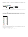
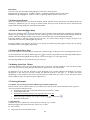
Select the Schedule tool
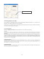
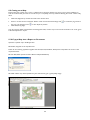
to get this screen:
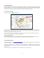
The layers are listed in alphabetical order. Choose the Field Boundaries layer and it will shift into the right hand box,
with all the parcel numbers showing below. Position the cursor over any parcel number or ID in the list and that area
will immediately be highlighted and centred on the map.
Now click on the layer name “Field Boundaries” in the right hand box and the layer will be restored to the main list.
Select the layer Spring Barley and you should see 2 fields listed.
6.13.2 Save the Schedule
When you have the required list, click on the File button at the bottom of the left hand panel and save the file. You
can now switch to Excel and open it – but remember to select Files of Type Text (.csv) in Excel.
6.14 Google Earth Link
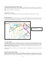
To install Google Earth go to http://www.earth.google.co.uk and select Downloads. Installation is straightforward and
only takes 3 - 4 minutes.
In PT-Mapper, select the area, line or object then click on the Google Earth icon
above the map. PT-Mapper
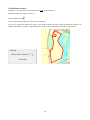
will launch Google Earth and take you to that very place with the boundary or line that you selected superimposed on
the aerial image.
In Google Earth, you can use the Plot Area or Plot Line tools to draw on the aerial image.
37