1
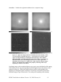
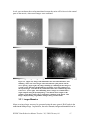
WIYN High-Resolution Infrared Camera
(WHIRC)
Quick Guide to Data Reduction
Dick Joyce
Version 1.01, 2009 February 04
WHIRC Data Reduction Manual Version 1.01, 2009 February 04
1
ACRONYMS AND ABBREVIATIONS:............................................................................................................. 2
1.0
INTRODUCTION.......................................................................................................................... 3
2.0
DATA PREPARATION ................................................................................................................ 3
2.1
2.2
2.3
3.0
INITIAL STEPS .............................................................................................................................. 4
GENERATING DOME FLATS .......................................................................................................... 5
GENERATING SKY FLATS ............................................................................................................. 8
DATA REDUCTION ..................................................................................................................... 8
3.1
3.2
3.3
STANDARDS OR POINTLIKE OBJECTS ........................................................................................... 8
EXTENDED OBJECTS OR CROWDED FIELDS .................................................................................. 9
COMBINING IMAGES INTO A MOSAIC ........................................................................................... 9
Acronyms and Abbreviations:
DHE
FITS
GUI
IAS
MOP
PAN
OA
TCS
WHIRC
WIYN
WHOCS
WHOMP
WTTM
Detector Head Electronics (MONSOON system)
Flexible Image Transport System (image standard)
Graphical User Interface
Instrument Adapter System
MONSOON Observing Platform
Pixel Acquisition Node (computer), controls MONSOON
Observing Associate
Telescope Control System
WIYN High Resolution InfraRed Camera
Wisconsin Indiana Yale NOAO (Observatory consortium)
WHIRC Observation Control System
WHIRC Observation Manager and Planner
WIYN Tip/Tilt Module
WHIRC Data Reduction Manual Version 1.01, 2009 February 04
2
WIYN High-Resolution Infrared Camera
(WHIRC) Data Reduction Guide
1.0
Introduction
This document is a quick guide to reducing data taken with the WIYN High Resolution
Infrared Camera (WHIRC). Data reduction is a highly personal process, so one should
keep in mind the procedures described here are biased by the author’s personal
preferences and experience. Many WHIRC users may have their own (possibly superior)
means of reducing data, or use reduction platforms other than IRAF. Suggestions from
the user community will be welcomed.
As noted in the User Manual, the high and variable sky (and telescope) background in the
infrared results in background flux levels on the detector which are often far larger than
the astronomical signals which one is attempting to detect. In addition, the architecture
of infrared arrays is one of independently read out pixels, rather than the charge transfer
utilized with CCDs. Dead or “hot” pixels (with high dark current) therefore show up as
isolated features on infrared images. As with CCDs, observations of a uniformly
illuminated target (flatfields) are used to calibrate the pixel sensitivity function of the
images.
Both the high sky background and the problem of isolated dead or hot pixels are
addressed by taking multiple images of a field, moving the telescope a small distance
between integrations. This technique, referred to as “nodding” or “dithering”, results in
sampling a target at several locations on the array, so the effects of bad pixels can be
minimized. Except in very crowded fields or those with extended structure, one is also
measuring the sky level on every pixel by moving the sources around after each
individual exposure.
2.0
Data Preparation
During a night of observing, one will generally obtain the following types of
observations:
1. Flatfields: We recommend a series of dome flats in each of the filters used, at least 10
each with the lights on and an equal number with the lights off. The latter will serve as
the bias and dark subtraction. One can also generate sky flats using sky frames generated
from the observations and a series of darks of the same integration time. Sky flats may
be more suited for reduction in the Ks filter, where there is significant thermal
background, but this is still under investigation. Observations in the narrowband filters
will generally not accumulate sufficient flux for high S/N flatfields.
WHIRC Data Reduction Manual Version 1.01, 2009 February 04
3
2. Science Observations: These can be a series of dithered observations on the source
field (for standards and pointlike sources) or a set of dithered observations on the source
and a set of dithered observations at an off-source sky location.
3. Darks: These are not really required for data reduction, because the process of sky
subtraction will also subtract out any dark current or bias structure. However, a series of
at least 10 short (5 s) darks are a useful diagnostic for evaluating the read noise. If one
generates sky flats, darks at the same integration time are needed.
2.1
Initial Steps
Independent of the reduction platform or individual techniques used for reduction, there
are several steps which should be carried out on all of the data frames prior to any
reduction.
1. Trimming: The raw data frames have 128 columns of reference pixels (Fig. 2.1) on
the right side which are presently of no use and will just make things ugly during the
reduction. We suggest trimming these off of all of the data frames; e.g.,
imcopy *.fits[1:2048,1:2048] *.%fits%tr.fits%
Figure 2.1: Raw Ks band image before (left panel) and after (right panel) trimming.
There is one bad column (97) on the detector. The bright spot in the center of the
field is the pupil ghost.
2. Scaling: If any of the data were taken with Fowler-4 mode, the pixel values must be
normalized by a factor of 4 prior to any linearity correction. The Fowler-4 mode adds all
of the four readouts but does not divide by 4 to avoid possible noise digitization in the
integer output format. So for the Fowler-4 data only:
WHIRC Data Reduction Manual Version 1.01, 2009 February 04
4
imarith *.tr.fits / 4. *.tr.fits
will do this in place.
A safer way to do this is to write all of the data to a list, generate a list of the Fowler
samples for all of the data, then divide:
files *.tr.fits > trlist
hselect @trlist fowler yes > flist
imar @trlist / @flist @trlist
3. Linearity correction: As the wells in the array fill up, the gain changes slightly,
resulting in a slightly sublinear response, which is approximately 4% at 38000 ADU. We
have carried out a quadratic fit to the linearity function for 0.7 v bias up to a value of
38000 ADU. By inverting this function, one can derive a linearity correction function so
that the corrected signal S’ is related to the raw signal S by
S′ = S * (A + B*S + C*S2), where
A = 1.0000
B = 1.29 × 10⁻⁷
C = 2.506 × 10⁻¹¹
A′ = 1.0000
B′ = 0.004227
C′ = 0.02691
The IRAF task irlincor is specifically designed to carry out this correction; the coefficients
A′, B′ and C′ above are the irlincor values. It is critical that linearity correction be
performed on the raw data, prior to any sky or dark subtraction, but after any scaling for
multiple Fowler sampling..
Do an epar irlincor and enter the above values for A’, B’, and C’ into the parameter file
(control-D to exit), then
irlincor *.tr.fits *.%tr%lc%.fits
4. At this point you will have three sets of data; you may want to archive the original raw
data somewhere, and the trimmed (.tr.fits) data can be deleted; the
trimmed/scaled/linearized data (.lc.fits) will be used for reduction.
5. We are working on a script which will carry out all of these procedures, as well as
editing the WCS parameters to reflect any custom rotator angle offset used for the
observations (e.g., to fit an elongated target onto the array).
2.2
Generating Dome Flats
WHIRC Data Reduction Manual Version 1.01, 2009 February 04
5
It is generally a good idea to run imstat on the flats just to identify any possible bad
frames and eliminate them from the input data.
1. For each of the on/off sets in the filters, imcombine each set into a single image (e.g.,
flat.k.on, etc.). One can generally use average, with avsigclip rejection, although median
should work as well. For the ‘lamp on’ images, one can scale the images using the mean
of a large subregion [500:1500,500:1500] to take out the effects of any drift in the lamp
intensity during the observation. The ‘lamp off’ data generally does not require scaling,
since the numbers are small.
Figure 2.2: Flatfield images at Ks with the flat lamp on (left panel) and off (right
panel). Note there is substantial thermal background flux even with the lamp off.
2. Subtract the ‘lamp off’ from the ‘lamp on’ image to yield a dark-bias subtracted flat.
3. It is useful to normalize the flats to 1.0 using a fairly large subregion such as
[500:1500,500:1500] to keep the science data values from changing too much after the
flatfielding operation.
4. It is also worthwhile to use the IRAF routine imreplace to eliminate very small or
negative numbers from the flat so one does not get enormous numbers in the flatfielded
science images. I typically use a replacement value of 1.0 and an upper limit of 0.02,
keeping the lower level at INDEF.
5. One can also generate a bad pixel map, but the procedures for WHIRC flats are still in
the experimental stage. There are a lot of circular “dimples” in the WHIRC array (Fig
2.4) which appear to be dead, but are actually regions of reduced sensitivity and cannot
be simply handled using the standard bad pixel map thresholds. In fact, these regions
flatfield out fairly well and are a legitimate feature of the flatfield image.
WHIRC Data Reduction Manual Version 1.01, 2009 February 04
6
6. In addition, the pupil ghost in the center of the array will give a falsely depressed
signal in the flatfielded data. We are still working on generating the correction for this
artifact.
At the end of this procedure, you will have a normalized flatfield for each of the filters.
Figure 2.3: Normalized flat for Ks (left panel) and J (right panel). The significant
difference in the two emphasizes the need to obtain dedicated flats in each filter used
for observing. The pupil ghost in the J band is much less prominent, but there is a
noticeable “fingerprint” artifact, probably resulting from a defect in the
antireflection coating on the array. Note that the bad column has been set to a value
of 1.0 by imreplace.
Figure 2.4: Expanded subregion of H band image, showing some of the “dimples”
on the detector (left panel). These are not dead pixels and appear to divide out
using a flatfield (right panel) to within 1 – 2 %.
WHIRC Data Reduction Manual Version 1.01, 2009 February 04
7
2.3
Generating Sky Flats
We have not yet determined whether sky flats or dome flats are better for data reduction.
Except for the H and Ks bands, though, the sky flux is generally much too small to
generate high S/N flats. We have no experience in attempting to obtain twilight flats, but
note that the onset of twilight is much more rapid in the infrared than in the visible, so
there is very little time to carry out this procedure. In the Ks band, where thermal
background from the telescope and WTTM optics contributes to the background and the
pupil ghost, one might expect sky flats to be worthwhile. Since sky flats can be
generated from the target observations, it is safer to get dome flats in any case.
1. Sky flats are best generated from a series of observations which give an appreciable
(several thousand ADU) sky level. This pretty much restricts nighttime observations to
the H and Ks filters.
2. You will need to take a series (~ 10) of dark frames (using the OPAQUE filter) at the
same integration time as used for the observations being used to generate the sky flat; this
will subtract out any bias and/or dark current. Average the dark frames.
3. Generate a sky image as described in the following section. Ideally, one should use a
large number (10 or more) of images, at more or less the same airmass, with several
thousand ADU of background.
4. Subtract the averaged dark frame from the sky frame. Normalize as for the dome
flats.
3.0
3.1
Data Reduction
Standards or Pointlike Objects
1. Usually one will have several images of the field with different telescope pointings.
Depending on the sky stability, the sky level may be somewhat different in each of the
images.
2. One may create a “master” sky image by imcombing all of the images in a given filter
on each target field using median filtering. Since the sky level will probably be
changing, one should scale the image using the median value of a large subraster such as
[500:1500,500:1500]. Ideally, this will result in a sky image in which all of the stars
have been eliminated. This may not work in extremely crowded fields. For very
crowded fields or those containing an extended source, one should take dedicated sky
observations (see below).
WHIRC Data Reduction Manual Version 1.01, 2009 February 04
8
3. Inspect the sky image and if it looks OK, generate sky-subtracted images by
subtracting the sky image from each of the original images. If the sky level had changed
during the observation series, some of the sky levels may be positive, some negative.
Keep going.
4. Divide each sky-subtracted image by the flat for that filter. Ideally, this will result in
images in which the (non-zero) sky level is uniform across the image. One can subtract
this offset out by measuring the median level of the image and subtracting that number.
If one is doing aperture photometry, the sky level should be automatically subtracted
during that process.
5. One may analyze the results from each image separately or combine them, using
upsqiid or other custom routines.
3.2
Extended Objects or Crowded Fields
1. As with the pointlike fields, one should have several dithered images of the science
field, but also a set of dithered images taken at a not too distant “sky” position.
2. Combine the off-target sky images as above using median filtering.
3. Subtract the sky image from each of the target images to yield the sky-subtracted
image.
4. Flatfield the sky-subtracted images as above.
5. One may analyze the results from each image separately or combine them, using
upsqiid or other custom routines.
3.3
Combining Images into a Mosaic
For IRAF users, the upsqiid package written by Mike Merrill can be used to align and
combine the images into a single image. This is primarily useful for deep imaging, where
one is observing the same field with relatively small dither amplitudes, since it relies on
locating star(s) common to all images for alignment. Although this was written primarily
for data from the 4-color imager SQIID, the routines for aligning and combining
individual images into a mosaic are applicable for WHIRC images. A description of the
upsqiid package, as well as instructions for downloading the package into IRAF, can be
found at http://www.noao.edu/kpno/sqiid/upsqiidpkg.html.
Three basic tasks which have been found useful for combining images are:
xyget – Find common stars in the images and create a registration database
zget – Find intensity offsets from overlap regions in the registration database
WHIRC Data Reduction Manual Version 1.01, 2009 February 04
9
nircombine – Combine the registration database into a composite image
Figure 3.1: (upper left) Image of the NGC 7790 field at Ks, after trimming. This is
one of nine images of the field, taken in a 3 × 3 grid with 50 arcsec spacing. (upper
right) Sky image obtaining by combining the nine input images with a median
filtering algorithm. (lower left) Difference of the top two images. Note that the sky
subtraction reduces the residual background to near zero. (lower right) After
flatfielding, the nine images are combined into a single composite using the upsqiid
package. Note that the noise is higher in the periphery of the image where only a
single image contributes to the mosaic.
Combining images with extended nebulosity may require some individualized fine tuning
of the intensity levels, since the algorithm used in the zget task uses the statistics of the
common overlap area. While this should in theory produce good matching at the
periphery of overlapped regions, sometimes it is necessary to tweak the levels in the
individual images to get a better match. Even with perfect matching of the intensity
WHIRC Data Reduction Manual Version 1.01, 2009 February 04
10
levels, one can detect the overlap transitions because the noise will be lower in the central
parts of the mosaic, where more images were combined.
Figure 3.2: (upper left) Image of the M42 field in the narrowband H2 filter, after
trimming. This is one of five images of the field, taken in a plus pattern with 50
arcsec spacing. (upper right) Sky image obtaining by combining the five images of
a nearby sparse field with a median filtering algorithm. (lower left) Difference of
the top two images. Note that the sky subtraction reduces the residual background
to near zero. (lower right) After flatfielding, the five images are combined into a
single composite using the upsqiid package. Note that the noise is higher in the
periphery of the image where only a single image contributes to the mosaic. This
image is displayed using a logarithmic scaling to bring out faint details.
3.3.1 Larger Mosaics
Maps covering a larger area may be generated using the more generic IRAF tasks in the
noao.imred.irred package. In particular, the tasks irmosaic, iralign and irmatch2d can be
WHIRC Data Reduction Manual Version 1.01, 2009 February 04
11
used in a manner analogous to the upsqiid tasks noted above, except that the iralign task
works in the overlap region between two adjacent images only. The only precondition is
that the input images have some spatial overlap with their neighbors.
The irmosaic task combines the input images into a single N x M mosaic, in the same
geometry that they were taken on the sky. One then uses iralign to identify pairs of stars
common to adjacent images until all nearest neighbors have been matched. The
separations between these stars in the mosaic image is written to a database. The
irmatch2d task shifts the images in the original mosaic to that the adjacent stars match up,
creating a single composite image.
NOTE: Because WHIRC is designed to exploit the good seeing at WIYN, particularly
once WTTM is operational, it is expected that it will be used mostly for deep mapping of
relatively small areas. Other instruments, such as NEWFIRM, are better suited to widefield surveys. We have not yet attempted a map of a large area and thus have no
experience in dealing with the geometric distortions of a WHIRC image which may
affect the creation of a wide field mosaic. The off-axis optics in WTTM result in slightly
different plate scales in the X and Y coordinates; in addition, there is some minor
keystoning at the 1% level which may require correction prior to creating a large mosaic.
WHIRC Data Reduction Manual Version 1.01, 2009 February 04
12