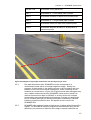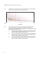
1
SCANNER surveys for Local Roads
User Guide and Specification
Volume 3
Advice to Local Authorities:
Using SCANNER survey results
Version 1.0
2011 Edition
SCANNER User Guide and Specification Volume 3
Contents Amendment Record
This report has been issued and amended as follows:
Issue
Revision
Description
Date
1.0
1.0
First published version of
2011 specification
March
2011
Department for Transport
Great Minster House
76 Marsham Street
London SW1P 4DR
Telephone +44 (0) 207 944 8300
Website www.dft.gov.uk
Signed
Using SCANNER survey results
Acknowledgement
This SCANNER User Guide has been developed from the SCANNER specification used in
2009. It incorporates many detailed changes based on experience of using the SCANNER
specification in 2005/06 2006/07 and 2009, the TTS specification before that in 2003/04 and
2004/05 and a wide range of comments from interested parties. It includes the results of
research on developing SCANNER commissioned on behalf of the UK Roads Board.
The previous SCANNER specifications were based on the original "TRACS Type Surveys for
the Principal Road Network – Specification and Advice Note" produced for the UK Roads
Board by the Chris Britton Consultancy and TRL Limited.
Throughout the development of the TTS and SCANNER specifications, considerable
assistance and support has been given by members of the SCANNER Implementation
Group, including local authority representatives, by TRL Limited, by the Chris Britton
Consultancy, by SCANNER survey contractors, by Halcrow, by Nick Lamb Consultancy Ltd
and by UKPMS developers.
This document was prepared by TRL Limited, under the PCIS support contract
SCANNER User Guide and Specification Volume 3
Contents
1
Introduction ....................................................................................................................7
1.1
1.2
2
3
4
What is SCANNER? ............................................................................................7
SCANNER surveys..............................................................................................7
SCANNER Parameters ..................................................................................................9
2.1
Introduction..........................................................................................................9
2.2
Location referencing ............................................................................................9
2.3
Road Geometry .................................................................................................10
2.4
Longitudinal profile.............................................................................................10
2.5
Transverse profile..............................................................................................12
2.6
Edge Condition ..................................................................................................14
2.7
Texture depth ....................................................................................................18
2.8
Cracking ............................................................................................................22
The SCANNER Road Condition Indicator.....................................................................25
3.1
Requirements of a Road Condition Indicator......................................................25
3.2
Developing the SCANNER RCI .........................................................................25
3.3
How the SCANNER RCI value is calculated ......................................................26
3.4
3.5
Reporting road condition using the SCANNER RCI ...........................................29
National reporting ..............................................................................................32
3.6
Benchmarking between local authorities............................................................33
3.7
Future development of the SCANNER RCI........................................................33
Using SCANNER results ..............................................................................................34
4.1
Knowledge of asset condition ............................................................................34
4.2
Identifying maintenance need ............................................................................36
4.3
Prioritising within available resources ................................................................40
5
4.4
Area or region condition reporting......................................................................40
References...................................................................................................................41
6
Annex 1 – SCANNER parameters................................................................................43
6.1
Road Geometry .................................................................................................43
6.2
Longitudinal profile.............................................................................................44
6.3
Transverse profile and rut depth ........................................................................46
6.4
Edge condition...................................................................................................47
6.5
Texture depth measurements – single line ........................................................50
6.6
Texture depth measurements – multiple line......................................................51
Annex 2 – SCANNER RCI ....................................................................................................54
Using SCANNER survey results
Foreword
This document is one of a series of five describing the requirements for SCANNER
Surveys (Surface Condition Assessment of the National Network of Roads).
It replaces the revised SCANNER specification first published in March 2006, and
subsequent updates of February 2007 and 2009.
The five Volumes are:
1.
Introduction to SCANNER surveys
2.
Advice to Local Authorities – Procuring Surveys
3.
Advice to Local Authorities – Using SCANNER Survey Results
4.
Technical requirements – SCANNER Survey Data and Quality Assurance
5.
Technical requirements – SCANNER Survey Parameters and Accreditation
This Volume 3, Using SCANNER survey results, explains the background to
SCANNER Surveys and gives further guidance on the interpretation of processed
SCANNER data. It contains advice on receiving and using SCANNER data,
interpreting the results for local asset management and maintenance, and producing
and understanding performance indicators.
Volume 1 provides a brief introduction to the requirements for SCANNER surveys,
and is intended to be read as a free standing document, as well as providing an
overview of the other four volumes. It includes a glossary of terms and a list of the
SCANNER parameters as annexes.
Volume 2 contains advice to Local Authorities about procuring SCANNER surveys
under the SCANNER Specification and is to be read in conjunction with the other
documents. It includes advice on preparing contact documents, inviting bids,
assessing tenders and managing contracts. It includes a model contact document as
an annex.
Volume 3, Using SCANNER data, explains the background to SCANNER Surveys
and gives further guidance on the interpretation of processed SCANNER data. It
contains advice on receiving and using SCANNER data, interpreting the results for
local asset management and maintenance, producing and understanding
performance indicators, and reporting NRMCS results.
Volume 5, Technical requirements for SCANNER Survey Parameters and
Accreditation defines the technical requirements for the parameters provided by the
machine developer, including acceptance and consistency testing and accreditation.
It describes the requirements for accreditation of the Equipment. It also describes the
requirements for consistency testing and for the reporting and delivery of data from
SCANNER accredited surveys.
5
SCANNER User Guide and Specification Volume 3
Typical survey vehicles
Jacobs RST26 vehicle
WDM RAV4 vehicle
Yotta (DCL) ARAN1 vehicle
6
Section 1 – Introduction
1
Introduction
1.1
What is SCANNER?
1.1.1
SCANNER stands for “Surface Condition Assessment for the National Network
of Roads” and is a specification for automated road carriageway condition
surveys.
1.1.2
The specification defines the set of data that should be collected by survey
vehicles on local roads, and how this should this processed and delivered.
1.1.3
The specification also defines the required level of accuracy for the data and
how survey vehicles (machines) will be tested to ensure that they are compliant
with the specification (acceptance testing), in order to obtain an accreditation
certificate.
1.1.4
The specification includes the requirement for annual re-testing for continuing
compliance with the specification to secure further annual accreditation
certificates.
1.1.5
The parameters delivered by the SCANNER survey are intended for use within a
pavement management system to report the condition of the road and to guide
and aid road carriageway maintenance management decisions, as part of an
overall asset management system.
1.2
SCANNER surveys
1.2.1
SCANNER surveys have been developed to provide a consistent method of
measuring the carriageway surface condition of classified local roads throughout
the United Kingdom. They have been developed to support five different
requirements (Figure 1.1):
(a)
As the basis for developing a detailed knowledge of the current
condition and value of the paved carriageway asset.
(b)
Replacing CVI and DVI surveys as the basis for defining the optimum
treatment selection on classified roads, and the optimum timing of
treatment, to prioritise treatment and minimise the whole life cost of
maintenance at a scheme or project level.
(c)
Replacing CVI and DVI surveys as the basis for indicative treatment
selection and budget estimation, to enable local authorities to plan
carriageway maintenance at a network level.
(d)
As an indication of the overall condition of a defined road network, to
replace network level Deflectograph and CVI surveys.
7
SCANNER User Guide and Specification Volume 3
(e)
As an indication of the overall condition of a specific length of road
carriageway, or of an area of a road network, to establish long term
trends in road maintenance condition, replacing CHART in NRMCS.
Figure 1.1
1.2.2
1.2.3
8
Use of condition data (after Ekins and Hawker, 2003)
SCANNER surveys collect a number of different measurements and process
them to produce a number of “parameters” that describe the condition of the
road surface. These include:
(a)
The longitudinal profile along the road, which characterises the ride
quality of the carriageway (the service level experienced by the road
user) and can be an indicator of structural condition (the maintenance
requirement).
(b)
The transverse profile across the road, including the presence of ruts,
which can be an indicator of structural condition (maintenance
requirement) and may also affect ride quality and safety (service level
experienced by the road user).
(c)
The condition of the edge of the road, which can be an indicator of the
need for an edge treatment (maintenance requirement) and may also
affect serviceability and safety.
(d)
The texture depth, which may be required for serviceability and safety,
and the texture depth variability which may be an indicator of surface
deterioration.
(e)
The presence and extent of surface cracking, which can be an indicator
of surface or structural deterioration and the need for maintenance.
SCANNER surveys are not visual inspections. They do not identify the condition
of a road in the same terms as a visual inspection. In a visual survey a trained
and experienced inspector interprets the visible signs in the overall context and
reports the condition of a length of road carriageway. In SCANNER surveys a
machine measures parameters, which have to be interpreted to produce a
meaningful result.
Section 3 – SCANNER parameters
2
SCANNER Parameters
2.1
Introduction
2.1.1
This section describes the SCANNER measurements, the parameters
derived from those measurements, and the parameters delivered to UKPMS
(in an HMDIF file) for subsequent processing.
2.1.2
The descriptions presented in this section are presented as guidance for
users. The formal technical requirements for the delivered data are specified
in Volume 4.
2.1.3
Further technical information on the measurement and use of the SCANNER
parameters is also given in Annex 1.
2.2
Location referencing
2.2.1
All data delivered by the SCANNER survey is provided in reference to the
Employer’s road network.
2.2.2
The fitting of the data to the network is carried out by the Contractor.
Contractors often achieve this by manually recording the location of section
change points during the survey (e.g. with a manual event marker installed in
the survey vehicle). Following the completion of the survey the events
recorded are aligned with the network information provided by the Employer
so that the survey data can be delivered (within an HMDIF file) relative to
distance travelled within section and lane.
2.2.3
By aligning SCANNER data with the UKPMS defined road network (i.e.
ensuring that the network provided to the Contractor is the same as that
defined within the Employer’s UKPMS) it can be used with other survey data
(such as visual inspection data) and with historic data that is referenced
directly to the UKPMS network. The data can also be used with any
functionality specified through UKPMS, such producing the SCANNER Road
Condition Indicator.
2.2.4
In addition, the position of the survey vehicle during a SCANNER survey is
reported at intervals of approximately 10m along the survey route. The three
SCANNER position co-ordinates are reported as:
UKPMS code LCOO
SCANNER survey parameter
OBVAL\30 =
SCANNER or TTS “x” co-ordinate
OBVAL\31 =
SCANNER or TTS “y” co-ordinate
OBVAL\32 =
SCANNER or TTS “z” co-ordinate
2.2.5
The “x” and “y” co-ordinates are OSGB36 National Grid Co-ordinates
(eastings and northings) and the “z” co-ordinate is altitude (height). These
co-ordinates can be used to assist in accurately locating the data on the
Employers road network.
2.2.6
Experience has shown that Contractors sometimes have difficulty aligning
SCANNER survey data with road networks. Problems occur where road
networks have not been kept up to date, where section start and end points
have not been accurately defined, or have not been clearly defined.
9
SCANNER User Guide and Specification Volume 3
2.2.7
To improve the fitting of SCANNER data the Employer is required to provide
National Grid Co-ordinates of the section start and end points to the
Contractor. This enables Contractors to align SCANNER survey data using
the measured position co-ordinates.
The requirements for identifying section start and end points are specified in
Volume 4, section 2.2, with outline guidance on selecting section start and
end points for SCANNER surveys.
2.3
Road Geometry
2.3.1
SCANNER measures the gradient, the cross-fall and the radius of curvature,
which are reported at intervals of approximately 10m as UKPMS codes:
UKPMS code
SCANNER survey parameter
LCRV =
SCANNER or TTS (radius of) Curvature
LFAL =
SCANNER or TTS Crossfall
LGRD =
SCANNER or TTS Gradient
2.3.2
SCANNER measures road geometry from the vehicle, not on the road itself.
Therefore there may be differences between the values measured on the
path the vehicle follows and those that a surveyor might measure carrying
out a detailed total station survey. There may be slight differences between
the values on the road centreline and the centre of each lane, and between
the centrelines in each lane. However, research has shown that these
differences are likely to be relatively small in most places on local roads.
2.3.3
It is recommended that Curvature (the inverse of radius of curvature) is used
when presenting geometry information along the length of a road, rather than
radius of curvature. Curvature is larger where the road bends and smaller
where it is straight, and is more easily interpreted by eye (e.g. on a graph)
than radius of curvature.
2.4
Longitudinal profile
2.4.1
SCANNER reports the longitudinal profile of the road, in both the nearside
and offside wheel paths, as a number of parameters, each reported at
intervals of approximately 10m as UKPMS codes:
10
Section 3 – SCANNER parameters
UKPMS code
SCANNER survey parameter
LV3 =
SCANNER or TTS 3m moving average LPV (left /
nearside)
LL03 =
SCANNER 3m enhanced LPV (left / nearside)
LV10 =
SCANNER or TTS 10m moving average LPV (left /
nearside)
LL10 =
SCANNER 10m enhanced LPV (left / nearside)
LLBI =
SCANNER Bump intensity (CDM) (left / nearside)
LR03 =
SCANNER 3m enhanced LPV (right / offside)
LR10 =
SCANNER 10m enhanced LPV (right / offside)
LRBI =
SCANNER Bump intensity (CDM) (right / offside)
2.4.2
The longitudinal profile is the shape of the road in the direction of travel (Figure 2.1).
Longitudinal profile variance (LPV) is a measure of how much the road undulates.
This can be reported at any scale, from a small scale, where it is a measure of
“bumpiness” to a large scale, where it is a measure of the topography. LPV is
important for two reasons – it is the main factor controlling ride quality and hence user
perception of road condition, and it can be a good indicator of defects in the surface
course, the binder course and the base (road base).
2.4.3
The SCANNER research programme recommended a number of changes to the
SCANNER specification that were introduced from 2007 onwards. In summary,
(a)
the measurement of longitudinal profile is required in both wheel paths
(b)
a new method of analysing the data was added to give the enhanced
LPV as well as the moving average LPV
(c)
a new measurement of “bump intensity” was introduced
(d)
30m LPV is no longer reported
2.4.4
Research showed that users’ perceptions of ride quality on local roads are
significantly affected by the longitudinal profile in the right (offside) wheel path as well
as the left (nearside) wheel path. Therefore the SCANNER specification has been
extended to include measurements in both wheel paths. At present only the
measurement in the left (nearside) wheel path is used in the SCANNER RCI and in
UKPMS indicative treatment selection.
2.4.5
The enhanced LPV has been introduced to replace moving average LPV. Enhanced
LPV correlated with users’ perceptions of ride quality better than moving average
LPV, and is a more stable, and hence a more reliable, parameter. The moving
average LPV measurements in the left (nearside) wheel path have been to enable
comparison with the values measured using TTS in 2004 and SCANNER in 2005 and
2006. However, once there is a reasonable overlap between the moving average and
the enhanced LPV measurements, the requirement to report moving average LPV
may be dropped.
11
SCANNER User Guide and Specification Volume 3
Figure 2.1
Example of a principal road where poor ride quality has been reported
2.4.6
Research showed that, although users’ perceptions of ride quality can be
related to longitudinal profile variance, the LPV was not always successful in
identifying large local bumps arising from features such as large local
depressions (e.g. failed patches). The bump intensity has been introduced to
identify these features. The measure simply reports the presence (or not) of
severe bumps in each 10m length. This measure is currently not used in the
SCANNER RCI.
2.4.7
The requirement to report 30m moving average LPV is no longer part of the
SCANNER specification. Research showed that it did not correlate with user
perception of road condition, and that it can be affected by road geometry.
30m LPV is not used either in the SCANNER RCI, or in treatment selection in
UKPMS.
2.4.8
Note that longitudinal profile measurements may be affected by factors such
as traffic calming features and vehicle speed and acceleration. The
Contractor is required to identify the presence of these features and remove
the longitudinal profile data that may be affected. This will lead to gaps in the
reported LPV parameters.
2.5
Transverse profile
2.5.1
SCANNER measures the transverse profile of the pavement. The
measurements of the transverse profile are analysed to produce the derived
SCANNER parameters, which are reported as average values at intervals of
approximately 10m using UKPMS codes:
12
Section 3 – SCANNER parameters
UKPMS code
SCANNER survey parameter
LLRT =
SCANNER or TTS left wheel path rut depth
LLRD =
SCANNER nearside rut depth from cleaned profile
LRRT =
SCANNER or TTS right wheel path rut depth
LRRD =
SCANNER offside rut depth from cleaned profile
LTAD =
SCANNER absolute deviation of 1st derivative of
transverse profile
Figure 2.2 Example of a principal road where ruts are beginning to form
2.5.2
Rut depth determined from SCANNER surveys corresponds to a
measurement made with a 2m straight edge and wedge. Rutting is a
symptom of deterioration in the wearing course or the foundation and is an
indicator of the need for structural maintenance, either a wearing course
treatment or reconstruction. (Figure 2.2) Engineers and asset managers may
use rut depth measurements from SCANNER exactly as they would use
machine measured rut depth in UKPMS, or as they would use rut depth
measured by trained and experienced inspectors. Average rut depth in the
left (or nearside) and right (or offside) wheel paths contributes to UKPMS
indicative treatment selection rules. Rut depths are also used in the
SCANNER RCI.
2.5.3
SCANNER also reports a further measurement of rutting called Cleaned Rut
Depths. The SCANNER research programme identified that rutting can be
affected by the presence of features at the edge of narrow roads such as
13
SCANNER User Guide and Specification Volume 3
verges that result in erroneously high rut depths. The Cleaned Rut Depth
represents the results of calculating the rutting following the application of an
algorithm to identify the road edge, hence removing edge features from the
rut calculation. The Cleaned Rut Depth is currently undergoing a trial phase
to determine its stability and accuracy, and is not included in the SCANNER
RCI or treatment selection. Users may wish to compare the Cleaned Rut
Depth data with standard rut depths on narrow roads, in particular when the
standard rut depths are unexpectedly high.
2.5.4
SCANNER also reports transverse profile unevenness (LTAD), which is a
measure of the Absolute Deviation of the First Derivative (ADFD) of the
Transverse Profile. This parameter assesses how much the slope of the
transverse profile changes from point to point across the carriageway. An
even surface would have a low ADFD value, whereas a saw-tooth profile
would have a high ADFD value. SCANNER transverse profile unevenness
(LTAD) does not contribute to either the SCANNER RCI or the UKPMS
indicative treatment selection rules. The measure may be of use when
assessing a narrow road where the transverse profile is uneven, but is not
appearing as deep rutting.
2.5.5
Note that the research programme recommended that two transverse profile
parameters required in earlier versions of the SCANNER specification should
be discontinued. However, these are retained within UKPMS, to enable all
the data reported in 2005 and 2006 to be processed in future:
UKPMS code
SCANNER survey parameter
LLAD =
SCANNER absolute deviation of 1st derivative of
nearside of transverse profile
LRAD =
SCANNER absolute deviation of 1st derivative of
offside of transverse profile
2.5.6
Note that transverse profile measurements may be affected by factors such
as traffic calming features. The Contractor is required to identify the presence
of these features and remove the transverse profile data that may be
affected. This will lead to gaps in the reported transverse profile parameters.
2.6
Edge Condition
2.6.1
SCANNER measures the edge condition profile of the pavement. The
measurements of edge condition are actually derived from the measured
transverse profile, which are analysed to produce the derived SCANNER
edge condition parameters. These are reported at intervals of approximately
10m using UKPMS codes:
14
Section 3 – SCANNER parameters
UKPMS code
SCANNER survey parameter
LTRV =
SCANNER transverse variance
LEDR =
SCANNER edge roughness
LES1 =
SCANNER road edge step L1 (between 20 and 50mm
step down)
LES2 =
SCANNER road edge step L2 (greater than 50mm
step down)
LEDC =
SCANNER edge coverage
2.6.2
The SCANNER measurement of edge deterioration is based on the initial
identification of the road edge within the transverse profile. This is used to
separate the verge from the road, and enables the calculation of various
parameters.
2.6.3
SCANNER transverse variance (LTRV) is the difference in the average
variance of the transverse profile height in the left and right halves of the
transverse profile, after the edge of carriageway has been detected and any
profile measurements to the left of the edge of carriageway have been
suppressed. It is a measure of the difference in the condition of the two
halves of the carriageway (Figure 2.3).
Figure 2.3
Illustration of the principle of the LTRV measurement on a minor road
2.6.4
SCANNER edge roughness (LEDR) is obtained from analysis of the laser
profile heights reported within consecutive transverse profiles (along the
road). The method reports the roughness within a half metre wide strip
adjacent to the road edge.
2.6.5
This SCANNER edge roughness measure (LEDR) can indicate where the
road surface at the road edge is likely to be in poor condition, but it cannot
identify which particular surface defects are likely to be present. The
15
SCANNER User Guide and Specification Volume 3
measure indicates irregularities in the edge surface but would not identify a
regular surface containing surface deterioration in the form of cracking or
crazing (Figure 2.4).
Figure 2.4
Figure 2.5
16
Illustration of the principle of LEDR measurement on a minor road
Examples of edge steps LES1 and LES2 identified by SCANNER on a minor
road
Section 3 – SCANNER parameters
2.6.6
SCANNER edge steps (LES1 and LES2) assess the height of the stepping
present within the transverse profile adjacent to the identified road edge
(Figure 2.5):
(a)
“LSL1” (LES1) = Percentage of reporting length with small step
down at the road edge (20 to 50mm).
(b)
“LSL2” (LES2) = Percentage of reporting length with large step
down at the road edge (greater than 50mm).
2.6.7
The SCANNER edge step measurement seems to provide a good indication
of verge over-riding on rural roads. It can also be used to provide an
indication of the level of edge support, and an implied indication of the
condition of the verge.
2.6.8
Trials have shown that the transverse profile measurement does not always
extend over the edge of carriageway and, even when it does, the edge
detection method does not always detect the edge of carriageway, because
there is no particular feature in the transverse profile. For example, in an
urban area there may be a kerb (which is easily detected) or a drive entrance
flush with the road surface (which is not detected). In a rural location there
may be a grassy verge with a definite step up or step down (which is easily
detected) or an extent of bare ground level with the carriageway (which is not
detected).
2.6.9
Therefore it is very important to know the number of transverse profiles within
which the edge of the carriageway has been detected. This is reported as
SCANNER edge coverage (LEDC). This value indicates the percentage of
the reporting length where the profiles have been measured over the edge of
the road. Where the value is low less confidence should be placed, in
particular, on the measure of edge stepping.
2.6.10
The SCANNER edge condition measurements are not used in the
SCANNER RCI. Neither are they used in UKPMS for treatment selection. A
single SCANNER edge deterioration indicator has been proposed that
combines the results of edge deterioration measurements (transverse
variance, edge roughness and edge step –Figure 2.6), which is based on the
same type of approach as the SCANNER RCI. A single indicator for edge
deterioration would reduce the work required in managing the multiple edge
parameters delivered by the SCANNER survey. It would offer a degree of
continuity with the edge condition indicator offered by current CVI surveys
and would be more appropriate for the network level assessment.
2.6.11
The single edge deterioration indicator can be calculated in UKPMS using
the SCANNER Edge CI weighting set.
17
SCANNER User Guide and Specification Volume 3
EDGE CONDITION INDICATOR
Edge steps
Transverse variance
Edge roughness
Figure 2.6 Illustration of the components of the edge condition indicator
2.6.12
Note that, because the edge deterioration parameters are derived from the
transverse profile, measurements may be affected by factors such as traffic
calming features. The Contractor is required to identify the presence of these
features and remove the transverse profile data that may be affected. This
will lead to gaps in the reported transverse profile and edge parameters.
2.7
Texture depth
2.7.1
SCANNER measures the texture of the pavement. The surface texture depth
measured by SCANNER is the coarser element of macro-texture and the
finer element of mega-texture of the pavement surface.
2.7.2
SCANNER texture can be separated into two groups – single line and
multiple line texture.
2.7.3
The measurements are analysed to produce the SCANNER texture
parameters. These are reported at intervals of approximately 10m along the
survey route using UKPMS codes:
18
Section 3 – SCANNER parameters
UKPMS code
SCANNER survey parameter
Single Line Texture
LLTX =
SCANNER or TTS Left Wheel Path Average Texture
depth (SMTD)
LLTD =
SCANNER Left Wheel Path Average Texture depth
(MPD)
UKPMS code
SCANNER survey parameter
Multiple Line Texture
2.7.4
LLTM =
SCANNER Left Wheel Path Mean RMST Texture
depth
LLTV =
SCANNER Left Wheel Path RMST Variance
LCTM =
SCANNER Centre Mean RMST Texture depth
LCTV =
SCANNER Centre RMST Variance
LRTM =
SCANNER Right Wheel Path Mean RMST Texture
depth
LRTV =
SCANNER Right Wheel Path RMST Variance
LT05 =
SCANNER Overall Texture Variability - RMST 5th
Percentile Value
LT95 =
SCANNER Overall Texture Variability - RMST 95th
Percentile Value
LTVV =
SCANNER Overall Texture Variability - RMST
Variance
Two texture profile parameters that were required in earlier versions of the
SCANNER specification are no longer required. These are retained within
UKPMS, to enable all the data reported in 2005 and 2006 to be processed in
future:
UKPMS code
SCANNER survey parameter
LCTX =
SCANNER or TTS Wheel Path Centre Average
Texture depth (SMTD)
LRTX =
SCANNER or TTS Right Wheel Path Average Texture
depth (SMTD)
19
SCANNER User Guide and Specification Volume 3
2.7.5
Single Line Texture
2.7.6
The texture of the surface helps to provide an indication of the high-speed
skidding resistance, which may affect road safety. It is in this context that the
measured SMTD (LLTX) is applied.
2.7.7
Specifications and thresholds for achieving and maintaining texture depth
have been set in the UK for many years on roads carrying large volumes of
high-speed traffic in order to maintain skid resistance performance in wet
conditions. In this context, “skid resistance” refers to the skid resistance at
HIGH SLIP SPEED, i.e. where the tyre is skidding over the surface texture at
speeds up to that of actual traffic speed. In contrast “skid resistance”
measurement by devices such as the SCRIM or GripTester is made at LOW
SLIP SPEED, typically less than 20km/h, because the test wheel is only
slipping over the surface at a fraction of the vehicle speed during the test.
2.7.8
As a result, there can be confusion over whether texture depth
measurements, such as SMTD or MPD, can be used instead of low slip
speed skid resistance measurements.
2.7.9
The SCANNER research established no evidence of any relationship
between texture depth measured by laser (SMTD) and low slip speed skid
resistance measured by SCRIM. Hence, texture depth cannot be used as a
reliable indication of the (low slip speed) skid resistance measured by SCRIM
or GripTester.
2.7.10
The skid resistance at low slip speeds is believed to be related to fine scale
surface (micro) texture and the relative simplicity of a non-contact, laser
measurement of texture depth would make it an attractive alternative to
conventional skid resistance measurements, if it were possible to measure
texture depth at a sufficiently fine scale. The SCANNER research found that,
even at the highest resolution, texture lasers cannot at present produce a
good representation of micro texture levels.
2.7.11
However, research into the relationship between texture depth, skid
resistance and accident risk has shown that texture depth is a significant
variable in explaining accident risk. Research has found that:
2.7.12
20
(a)
There are circumstances where low texture depths can be
associated with greater incidence of accidents. This trend appears
to hold consistently for accidents on dry roads, but it is not known
whether this is because braking performance on dry roads is also
better with higher surface texture, or because the distinction
between wet and dry is not reported accurately.
(b)
For most site categories, no correlation was observed between
texture depth and the accident density (accidents per km) or
accident rate (accidents per 100 million vehicle km). However, this
may reflect the small length of the network with low texture depths.
(c)
The trends in accident density were not generally supported by a
corresponding trend in accident rate, suggesting that while more
accidents occur on low textured surfaces, this could be because
there is more traffic on these parts of the network.
(d)
The overall picture confirms the importance of maintaining good
levels of texture depth, particularly on rural roads, and particularly
where the skid resistance is also low.
The average texture depth (SMTD) in the left (or nearside) wheel paths
(LLTX) is used both within the SCANNER RCI and also contributes to
UKPMS indicative treatment selection rules.
Section 3 – SCANNER parameters
2.7.13
Multiple Line Texture
2.7.14
Simple single line texture depth on its own is often a poor indicator of the
surface condition, or the need for maintenance treatment, of a road
carriageway surface because it can be acceptable at low, medium or high
values:
(a)
Where high friction surfacing is used, low texture depth is good. If
the average texture depth increases, this may indicate wear, which
is not good.
(b)
Where a modern negatively textured surface is used, medium
texture depth is good. Low texture depth is not good, and may
indicate excess bitumen on the surface due to poor mix design or
subsequent fatting up. High texture depth is not good, indicating
wear and fretting.
(c)
Where HRA and surface dressings are used, high texture depth is
generally good (although very high texture depth may indicate
fretting or chip loss) and low texture depth is not good, indicating
wear, embedment of chippings or fatting up.
2.7.15
The SCANNER research showed that measurement of the variability of
texture depth along and across road surfaces can be associated with road
surface wear (Figure 2.7), although it is also associated with the presence of
other features such as road markings.
2.7.16
The SCANNER survey therefore requires the measurement of texture in
multiple measurement lines for use in assessing the variability. The minimum
requirement is to measure texture profile on at least three lines, including the
nearside and offside wheel paths, and the line midway between them (Figure
2.8). However, Contractors can provide measurements in up to 40 lines.
2.7.17
The texture data reported as RMST in each measurement line is averaged
for the regions covering the wheel paths and the centreline and reported in
the SCANNER HMDIF. These values can be used to assess the variability of
the texture and hence identify deterioration. The variability of the RMST
texture values are discussed further in Section 6.6.
2.7.18
Neither SCANNER average texture depths (RMST) in the left (or nearside),
right (or offside) wheel paths and on the centre line, nor texture depth
variability and variance measurements, contribute to the SCANNER RCI or
the UKPMS indicative treatment selection rules. Initial values for the
thresholds and weightings for SCANNER average texture depths (RMST)
and texture depth variance and variability have yet to be developed.
21
SCANNER User Guide and Specification Volume 3
Figure 2.7
Variation in average texture depth across the road surface
Figure 2.8
Variations in texture depth along and across the road surface
2.7.19
Current laser texture measurement devices work by measuring the distance
between the sensor and the road surface. The laser technology used may
be affected by the presence of a shiny reflective film of water over the
surface. Therefore texture depth measurements can be unreliable on wet
roads.
2.8
Cracking
2.8.1
SCANNER measures cracking on the surface of the pavement, which is
reported as the location of each crack identified in the form of a crack map.
Each crack has UKPMS code LMAP, with parameters:
22
Section 3 – SCANNER parameters
UKPMS code LMAP
SCANNER survey parameter
OBVAL\2 =
Crack length
OBVAL\23 =
Offset position
OBVAL\24 =
Angle
OBVAL\25 =
Type code (crack or joint)
2.8.2
The crack map is reported in the SCANNER HMDIF, but UKPMS is not
currently configured to use this information. In future it may become possible
to overlay the crack map on the visual image of the road surface, and to
overlay the crack map on a detailed map of the road in a UKPMS accredited
system. At present it is only possible to view the crack map using proprietary
software provided by the survey companies. This proprietary software differs
between companies and has not been standardised as a SCANNER
requirement.
2.8.3
The cracks are analysed to produce the derived SCANNER cracking
parameters, which are reported as average values within the HMDIF at
intervals of approximately 10m using UKPMS codes:
UKPMS code
SCANNER survey parameter
LTRC =
SCANNER or TTS Cracking (whole carriageway)
LWCL =
SCANNER or TTS Left Wheel Track Cracking Intensity
LWCR =
SCANNER or TTS Right Wheel Track Cracking
Intensity
LRCR =
SCANNER Transverse/reflection cracking
LSUR =
SCANNER Surface Deterioration Parameter
2.8.4
The SCANNER measurement of cracking typically covers a survey width of
3.2m, although this can vary with the survey vehicle (minimum is 2.9m).
Whole carriageway cracking is obtained by overlaying the crack map with a
grid covering the whole survey width, and summing up the areas of the grid
squares containing cracks. The method by which the whole carriageway
cracking intensity is obtained from the crack map is given in volume 5. An
example of a cracked road surface is shown in Figure 2.9.
2.8.5
Wheel track cracking intensity is reported over two tracks, each of width
0.8m, centred on the wheel paths. Consequently the area considered for
wheel track cracking is typically about 50% of the area considered for whole
of carriageway cracking. SCANNER wheel track cracking is very different
from classic, visually recognised wheel track cracking. This is because the
engineer or inspector takes account of the orientation of the crack, along the
wheel path, before recognising and reporting it. Whereas SCANNER only
takes account of whether the crack lies mainly within the defined wheel track.
2.8.6
Both whole carriageway cracking and wheel track cracking contributed
independently to the “original” SCANNER RCI, used in 2006 and 2007.
Currently only the whole carriageway cracking contributes to the “revised”
SCANNER RCI.
23
SCANNER User Guide and Specification Volume 3
2.8.7
Both whole carriageway cracking and wheel track cracking contribute
independently to the UKPMS indicative treatment selection. Whole
carriageway cracking contributes to “strengthen”; “resurface” and “surface
treatment”. Wheel track cracking only contributes to “strengthen” and
“resurface”.
2.8.8
SCANNER identifies cracking by collecting video images and analysing them
automatically. The automatic detection and measurement of cracking on a
road surface is technically very challenging. Most road surfaces are
essentially “grey” and images of the road surface have “visual texture” in
terms of variability in the grey scale across the image. The variation in the
“visual texture” across the image tends to mask the cracks, which are
normally visible (in the image) as darker features.
Figure 2.9
Longitudinal and transverse cracking on a minor road
2.8.9
The identification of cracking relies on interpretation of the image recorded by
the particular crack identification software. The resolution of crack detection
systems employed on current SCANNER survey equipment typically limits
the minimum crack width detected to around 2mm. The automatic systems
quantify the extent of cracking in a different way from a visual inspection.
Consequently SCANNER cracking intensity does not replicate visual survey
cracking data, but will generally report a much lower percentage area of
cracking than would be reported from a visual inspection.
2.8.10
The SCANNER research developed further algorithms for the reporting of
crack parameters from the SCANNER crack map, including transverse
cracking and surface deterioration.
2.8.11
The method of identifying transverse / reflection cracking is described in
Volume 5. SCANNER transverse / reflection cracking (LRCR) has been
developed as a way of differentiating surface cracking by their cause, as a
guide to treatment selection. Appropriate treatment options are likely to
depend on construction type.
2.8.12
The method of identifying surface deterioration is also described in Volume 5.
The SCANNER surface deterioration parameter (LSUR) has been developed
as a way of detecting isolated areas containing crack like defects, as
opposed to continuous cracks.
2.8.13
Both of these new parameters are undergoing a trial period to assess their
value and are not used in the SCANNER RCI or in treatment selection.
24
Section 4 – The SCANNER Road Condition Indicator
3
The SCANNER Road Condition
Indicator
3.1
Requirements of a Road Condition Indicator
3.1.1
There are a number of differing requirements for a road carriageway condition
indicator.
(a)
To identify lengths of road where the condition has deteriorated and the
level of service may also have deteriorated. (As an input to planning
detailed investigation and maintenance)
(b)
To summarise the condition of a section or length within a network. (As
an input to maintenance planning)
(c)
To rank the lengths of road where the condition has deteriorated and
maintenance treatment may be required. (As an input to allocating
resources between different lengths of road requiring treatment)
(d)
To identify the type or types of treatment required on a length of road.
(As an input to estimating the overall requirement for resources)
(e)
To summarise the overall condition of a road network so that some
value can be ascribed to the network. (As an input to asset valuation
and management)
(f)
To summarise the overall condition of a road network, so that
comparisons can be drawn between different areas. (As an input to
performance indicators).
(g)
To summarise the overall condition of a road network, so that trends in
condition can be observed from year to year. (As an input to national or
local monitoring).
3.1.2
The SCANNER Road Condition Indicator (RCI) has been developed as a way of
characterising the condition of the road carriageway, which fulfils some, but not
all, of the requirements. It identifies lengths where the condition is poor and
enables their condition to be summarised and ranked. It can also be used to
summarise the overall condition of part or all of a road network, so that
comparisons may be made between different areas, and trends in condition can
be observed from year to year
3.1.3
It has specifically NOT been developed as a method of identifying the TYPES
OF TREATMENT required on a length of road, or to ascribe a VALUE to a
network.
3.2
Developing the SCANNER RCI
3.2.1
The SCANNER RCI has been developed through a process of research,
development, testing and refinement. This was carried out in three stages
(a)
Preliminary research leading to the “TTS Defects Index Preliminary
Analysis” (Cartwright and Pickett, 2004).
(b)
A review of the proposals and recommendations by the Defects Index
Working Group, set up by the UK Roads Board, in 2005, supported by
tests of the RCI on principal roads (McRobbie, 2006). This led to the
25
SCANNER User Guide and Specification Volume 3
original values used in the SCANNER RCI in 2006 on 2005/06 survey
data.
(c)
Review of the results with the initial values by the SCANNER RCI
Working Group, set up by the UK Roads Board, in 2006, supported by
further tests on classified roads (McRobbie et al, 2007). This led to
recommendations for a revised set of values used for reporting in 2007
and 2008.
3.3
How the SCANNER RCI value is calculated
3.3.1
Table 3.1 shows the parameters used within the calculation of the original and
extended RCI. To obtain an RCI value each parameter is scored between two
thresholds – a lower threshold below which there is no need to consider
maintenance, and an upper threshold above which further deterioration does not
increase the score. These thresholds were based on engineers’ experience of
each parameter. The score increases linearly between the lower and upper
threshold from zero at the lower threshold to 100 at the higher. Figure 3.1
demonstrates this procedure for rutting.
3.3.2
The thresholds for each parameter are given in Annex 2.
3.3.3
The score for each parameter is then multiplied by two factors, each having a
value between zero and one. One factor reflects the “relevance” or importance
of the measurement to the maintenance condition of the road. The other
reflects the “reliability” of the method of measurement.
26
(a)
The values used in the original SCANNER RCI for surveys carried out
in 2005/06 and 2006/07 (and reported in 2006 and 2007) are given in
Table 3.2
(b)
The values to be used in the revised SCANNER RCI for surveys
carried out in 2007/08 and subsequent years (and reported in 2008 and
subsequent years) are given in Table 3.3.
Section 4 – The SCANNER Road Condition Indicator
UKPMS code
SCANNER survey parameter
Original
RCI
Revised
RCI
Ride quality
(LV3)
3m longitudinal profile variance in nearside
(left) wheel path
Ride quality
(LV10)
10m longitudinal profile variance in nearside
(left) wheel path
Rut depth
(LLRD)
Average rut depth measured in the nearside
(left) wheel path
Rut depth
(LRRD)
Average rut depth measured in the offside
(right) wheel path
Cracking
(LTRC)
Whole carriageway cracking intensity
Cracking
(LWCL)
Wheel track cracking intensity measured in the
nearside (left) wheel path
x
Cracking
(LWCR)
Wheel track cracking intensity measured in the
offside (right) wheel path
x
Texture depth
(LLTX)
Average SMTD measured in the nearside (left)
wheel track
Table 3.1 SCANNER parameters used in calculating the SCANNER RCI
Figure 3.1
Example of scoring a SCANNER parameter – average rut depth
27
SCANNER User Guide and Specification Volume 3
Family
UKPMS
Code
Importance
factor
Reliability
factor
Overall
factor
Maximum
points
Rut depth (greater of
nearside and offside)
LLRT
0.9
1.0
0.9
90
LRRT
3m LPV
LV3
0.8
1.0
0.8
80
10m LPV
LV10
0.6
1.0
0.6
60
Whole carriageway
cracking
LTRC
0.9
0.55
0.5
50
Wheel track cracking
intensity (greater of
nearside and offside)
LWCL
0.9
0.44
0.4
40
0.5
1.0
0.5
50
Nearside wheel track
texture depth
LWCR
LLTX
Maximum total points
Table 3.2
370
Relevance and reliability factors for original SCANNER RCI used with 2005/06
and 2006/07 surveys
Family
UKPMS
Code
Importance
factor
Reliability
factor
Overall
factor
Maximum
points
Rut depth (greater of
nearside and offside)
LLRT
1.0
1.0
1.0
100
LV3
0.8
1.0
0.8
80 or
LV10
0.6
0.6
60
Whole carriageway
cracking
LTRC
1.0
0.6
0.6
60
Nearside wheel track
texture depth
LLTX
Varies
1.0
Varies
75, 50
0.75 to 0.3
or 30
LPV (higher scoring of)
3m and 10m
LRRT
0.75 to 0.3
Maximum total points
Table 3.3
3.3.4
Relevance and reliability factors for revised SCANNER RCI used with 2007/08
surveys and subsequent years
The values are then summed for each nominally 10m subsection of the survey,
giving a value
(a)
28
315 to 270
between zero (no reported deterioration) and 370 (maximum score on
all parameters) for the original SCANNER RCI.
Section 4 – The SCANNER Road Condition Indicator
(b)
between zero (no reported deterioration) and 315 (maximum score on
all parameters) for the revised SCANNER RCI.
3.3.5
The maximum value does not have any special significance, it simply represents
a sub-section on which all the parameters exceed the upper threshold value.
3.3.6
There is no way to convert a score from the revised RCI to the original RCI, or
vice versa. Either the original or the revised RCI may take a higher value.
3.3.7
Many lengths of road will have a score of zero, and this will include
carriageways in a wide range of conditions, from “nearly new” and “nearly
perfect” to “quite worn” and “quite old”.
3.3.8
The resulting values can be divided into three bands representing the overall
condition of the sub-section.
Band
Condition
Threshold
– Original
RCI
Threshold
– Revised
RCI
“RED”
condition
Lengths in poor overall condition which are
likely to require planned maintenance
soon (i.e. within a year or so) on a “worst
first” basis. There may be justification for
postponing major repairs, and only
carrying out minor repairs to keep the road
safe and serviceable, in order to minimise
whole life costs. i.e. “economic
prioritisation”.
>100
>100
= (plan
investigation
soon)
Lengths where some deterioration is
apparent which should be investigated to
determine the optimum time for planned
maintenance treatment. There may be
justification for carrying out a lesser
maintenance treatment sooner, rather than
more extensive treatment later, in order to
minimise whole life costs.
>20
>40
“GREEN”
condition
Lengths where the carriageway is
generally in a good state of repair.
N/A
N/A
= (plan
maintenance
soon)
“AMBER”
condition
Table 3.4
Definitions of red, amber and green carriageway condition
3.4
Reporting road condition using the SCANNER RCI
3.4.1
As the road condition deteriorates, and as the SCANNER measured parameters
change, the score on a subsection length will start to increase, depending on
which parameters are changing. As each parameter increases, the individual
score will gradually increase to a maximum value, at which point it will increase
no further. Consequently certain values of SCANNER RCI will be more
common than others. These are sub-sections where one or more parameters
have reached a maximum score, and the other parameters are not yet
contributing.
29
SCANNER User Guide and Specification Volume 3
3.4.2
This effect can be seen in Figure 3.2, which shows data from a representative
sample of 16 local authorities in England and Scotland.
Figure 3.2
3.4.3
30
Distribution of original SCANNER RCI values from a representative sample of
local roads
The research programme has carried out extensive investigation into the
behaviour of the RCI using data from sample authorities. A few of the
observations made in that work are presented here to provide a context in which
to place locally obtained RCI values.
(a)
Figure 3.3 shows the percentage of lengths classified as Red, Amber
and Green within a sample of 16 authorities, for the original RCI and
where the amber threshold has been set at 20.
(b)
Figure 3.4 shows the percentage of lengths classified as Red, Amber
and Green within a sample of 16 authorities, for the original RCI and
where the amber threshold has been set at 40
(c)
Figure 3.5 shows the percentage of lengths classified as Red, Amber
and Green within a sample of 16 authorities, for the revised RCI and
where the amber threshold has been set at 40
Section 4 – The SCANNER Road Condition Indicator
Proportion (%)
90
80
Origina l SCANNER RCI w ith a m be r a t 20 points
69.61
70
60
50
10
0
Gree n
15.67
Proportion (%)
13.58
11.12
6.39
B
Road category
C
U
Percentage length of red, amber and green from a representative sample of local
roads, using the original SCANNER RCI
90
80
70
78.91
Original SCANNER RCI with amber at 40 points
62.66
60.14
60
50
40
30
20
10
0
Am b er
35.39
24.00
A
Figure 3.3
Red
38.92
36.63
40
30
20
51.03
49.96
47.70
61.32
Red
Amber
26.22
24.20
15.67
14.71
A
13.58
11.12
6.39
B
Road category
Green
25.10
C
U
Figure 3.4
Percentage length of red, amber and green from a representative sample of local
roads, with original SCANNER RCI, and amber / green threshold at 40 points
Proportion (%)
90
80
80.34
Re vise d S CANNER RCI w ith a m b e r a t 40 p o in ts
68.36
70
60
50
40
30
20
10
0
68.96
66.33
Red
Am b e r
25.57
25.88
22.86
Gre e n
16.20
A
8.18
7.79
6.07
3.46
B
Roa d c a te gory
C
U
Figure 3.5
Percentage length of red, amber and green from a representative sample of local
roads, with revised SCANNER RCI, and amber / green threshold at 40 points
3.4.4
Note that, because of the accuracy of the network referencing, the precise start
and end position of each 10m sub section length will change from year to year.
Therefore care must be taken when aligning subsections and comparing results
31
SCANNER User Guide and Specification Volume 3
from year to year. In order to make comparisons between years, it is more
appropriate to combine the results along routes, sections or networks.
3.5
National reporting
3.5.1
Until 2009 the SCANNER RCI was used to report, at the national level, the
condition of principal (BV223) and other classified (BV224a) road networks.
These indicators report the length (as a %) of an authority’s network that falls
within the red band.
3.5.2
In 2009 BV223 and BV224a were replaced by NI168 and NI169 respectively.
More information about the English requirements is available on the Department
for Transport website (Department for Transport, 2007).
3.5.3
The original SCANNER RCI was used as the basis for reporting the English
BV223 and Bv224a up to 2007, based on the most recent survey results (i.e.
from 2005/06 and 2006/07 for reporting in 2007).
3.5.4
The revised RCI was used for reporting BVPI/NI from 2008, again based on the
most recent survey results (i.e. from 2006/07 and 2007/08 for reporting in 2008).
3.5.5
The results in England are reported by the Audit Commission.
3.5.6
Note that, during 2005/06 there were problems with the automatic software used
to detect cracking in the images collected by one of the machines used in
England. This made the reported amounts of both whole carriageway and
wheel track cracking unreliable. Therefore the SCANNER RCI was not a
reliable method of for comparison between those authorities that used that
survey machine, compared with other local authorities, and year on year. There
was no way of adjusting these results to make reliable comparisons. Therefore
the Audit Commission did not make any comparison between the results in
terms of quartiles. Neither were the results used as part of the Comprehensive
Performance Assessment (CPA) scores.
3.5.7
The following discuss a few of the observations made during the research, and
review of the nationally reported indicators:
32
(a)
There is evidence to suggest that there is a relationship between the
percentage of built-up principal roads in an authority (i.e. roads with a
speed restriction of 40mph or less) and BV223. This may be
associated with two factors. Principal roads in towns (a) have more
numerous junctions and (b) have more excavation and reinstatement
by utility companies. The junctions affect the longitudinal profile
measurements (ride quality) and the reinstatements can affect both ride
quality and crack detection, giving rise to some apparent cracking
where there is none.
(b)
There is little evidence of a relationship between the percentage red
length and the percentage of built-up roads on other classified roads.
(c)
The work undertaken on the development of the revised RCI led to
quite significant changes in the thresholds, and lesser changes in the
weightings, that are likely to markedly change the % red and % amber
lengths in many local authorities, and hence lead to significantly
different BV224a.
Section 4 – The SCANNER Road Condition Indicator
3.5.8
From 2007-2008, road condition in Scotland has similarly been reported on the
basis of the RCI. However, unlike England, the reported figure applies to the
total public road network, including unclassified roads, and reports on the
portion falling in both the red and amber bands. Although not statutory
performance indicators, the RCI results for each road class are also available,
specifying separately the portions falling in the red and amber bands. Prior to
2007_08 the Scottish results were reported on the basis of the “SPI”, which did
not include data on cracking.
3.5.9
In Scotland a single national survey contract has been awarded to collect the
data, from which the results are provided to individual local authorities for local
maintenance management purposes and for reporting to Audit Scotland as part
of their annual statutory PI returns. Details of the Scottish results can be found
on the SCOTS’ website www.scotsnet.org.uk by following the link on the home
page to “Road Condition Surveys”.
3.6
Benchmarking between local authorities
3.6.1
The SCANNER research has investigated whether there is any evidence for
grouping English local authorities for “benchmarking” comparisons, in the same
way that Scottish local authorities seem to fall into a number of natural groups
based on the percentages of their networks that are urban or rural. On the basis
of a detailed analysis of the results from 2005/06 surveys the work (McRobbie et
al, 2007) has concluded:
(a)
There are possibly three main groups of English highway authorities for
comparing principal road networks, but the groups overlap
considerably.
(b)
There are no obvious groups of English highway authorities for
comparing other classified road networks.
3.6.2
English local authorities are much more diverse in their make-up than Scottish
local authorities, and there are fewer obvious groupings for benchmarking
purposes. Therefore English local authorities would probably do better to select
a limited number of other authorities to compare their performance in managing
road networks, based on a wider range of environmental, social and economic
factors, rather than a limited number of characteristics of their road networks.
3.7
Future development of the SCANNER RCI
3.7.1
The SCANNER RCI Working Group used the experience of using the
SCANNER RCI on 2005/06 survey data, in the development of the revised RCI.
The Working Group subsequently recommended that an “extended” SCANNER
RCI should be introduced in the future (perhaps as early as 2009), via a new
weighting set that would include the new (e.g. edge, bump) parameters.
3.7.2
However, the Road Performance Management Group recommended,
postponement of the introduction of an extended RCI whilst the revised RCI was
fully implemented and accepted by authorities. The UK Roads Board therefore
decided that the “revised” set of parameters thresholds and weightings for the
SCANNER RCI should be retained for the immediate future, at least until local
authorities are more familiar with the interpretation of SCANNER survey results.
33
SCANNER User Guide and Specification Volume 3
4
Using SCANNER results
4.1
Knowledge of asset condition
4.1.1
At the simplest level the engineer or asset manager responsible for managing a
road network needs to know:
(a)
Which roads they are responsible for
(b)
What condition they are in
(c)
What maintenance is required and
(d)
The best time to carry it out.
4.1.2
The SCANNER accredited survey vehicle measures carriageway condition from
the perspective of a moving vehicle. It surveys one lane of the carriageway at a
time and produces numbers – a quantitative measure of carriageway condition.
4.1.3
SCANNER produces vastly more data than visual surveys, and therefore
requires a much greater capacity in the pavement, asset management and data
storage systems, both software and hardware. To be able to use SCANNER
survey data effectively, the engineer or asset manager will need comprehensive
IT support, both commercial software programmes such as pavement
management systems and asset management systems, linked to geographic
information systems (GIS), and the hardware to support them in terms of display
screens, personal computers, servers, network capacity (bandwidth) and data
storage systems.
4.1.4
SCANNER makes four sorts of measurement:
4.1.5
34
(a)
The profile of the road in the direction of vehicle travel along the road
(the longitudinal profile). This is important for two reasons – it is the
main factor controlling ride quality and hence user perception of road
condition, and it can be a good indicator of defects in the surface
course, the binder course and the base (roadbase).
(b)
The profile of the road across the direction of travel (the transverse
profile). This includes measuring rut depth. This is important for two
reasons – ruts or other transverse unevenness features can affect
steering or cause water to pond, both of which may affect road safety,
and it can be a good indicator of defects in the surface course, the
binder course and the base (roadbase).
(c)
The texture of the surface. This can be important for two reasons. It
helps to provide high speed skidding resistance on fast roads, which
may affect road safety. Variations in texture depth along or across the
road can indicate surface wear and the presence of defects in the
surface course.
(d)
Cracking visible at the surface. This can be important for two reasons.
It may indicate deterioration of the surface course, or of deeper seated
defects in the binder course and base. It may allow water to penetrate
through the pavement layers and weaken the foundations.
SCANNER measures the survey parameters more or less continuously along
the road. The survey contractor processes the measurements, either on the
survey vehicle during the survey, or in their offices after the survey [post
Section 6 – References
processing], fits the survey data to the road network, and reports the results as
“characteristic” values every few metres along the road.
4.1.6
Most of the parameters are reported as average values over survey subsection
lengths, which are approximately 10m long, along the road. They are reported
using a UKPMS HMDIF file (Smith, 2006) which can be loaded into any UKPMS
accredited pavement management system. The reported survey parameters
are described in more detail in section 3.
4.1.7
SCANNER does not measure the condition of footways, cycle paths or verges,
nor does it measure the appearance of the street from the perspective of a local
resident.
4.1.8
(a)
Quantitative information on the condition of footways, cycle paths and
verges could be gathered by visual inspections and combined with
information from SCANNER surveys in a pavement management
system.
(b)
Qualitative information about the appearance of the street could be
gathered through visual inspections or photographic surveys and
combined with information from SCANNER surveys in an asset
management system.
Although not part of the SCANNER core requirements, SCANNER survey
contractors will often offer video surveys as an extra dataset in conjunction with
their SCANNER surveys. This video data can be very useful, both as a way of
checking SCANNER survey coverage and of carrying out more detailed
investigation of specific lengths of road.
(a)
The video survey information provides a qualitative record of the
condition of the road at the time of survey and complements the
quantitative data gathered by SCANNER. Together they can provide
most of the information an engineer or asset manager needs to have a
detailed record of the carriageway asset condition at a particular time,
as well as qualitative information about the appearance of the street
including footways, verges and street furniture.
(b)
Increasingly local authorities are building detailed inventories of their
road assets. SCANNER provides quantitative information about the
condition of the carriageway, and a simultaneous video record can be a
useful way of checking for the presence, location and appearance of
the asset inventory items at a particular time.
4.1.9
Typically the video survey data consists of a sequence of good quality digital
images along the survey – often taken at 5m intervals. These can be strung
together to produce a “virtual video” of progress, or viewed individually for more
detailed examination. These will require greater capacity in the data storage
system and development of the pavement or asset management system to
enable the SCANNER results to be compared with the photographic images in a
GIS presentation. This can be a large data storage and management exercise –
particularly if a video survey is carried out with every SCANNER survey.
4.1.10
SCANNER does NOT measure surface skidding resistance or the stiffness of
the pavement layers.
(a)
Surface skidding resistance can be measured using systems like
SCRIM or Griptester. Research carried out as part of SCANNER
development has shown that surface texture CANNOT be used as a
35
SCANNER User Guide and Specification Volume 3
proxy for skidding resistance on local roads in the UK (Viner et al.,
2006).
(b)
The stiffness of the pavement layers can be measured using systems
such as Deflectograph or Falling Weight Deflectometer (FWD) and
interpreted as a measure of pavement strength and “residual life”, in
the case of the Deflectograph. SCANNER measurements CANNOT, at
present, be interpreted to give a measure of residual life.
4.1.11
Measurements of skidding resistance and pavement deflection (stiffness) can be
combined with SCANNER measurements in pavement and asset management
systems.
4.1.12
Other measurements, such as ground penetrating radar, and the results from
coring and test pits, can also be combined with SCANNER results in some asset
management systems.
4.1.13
The reports from visual inspections can also be combined with SCANNER
measurements in UKPMS and used in pavement and asset management
systems.
4.2
Identifying maintenance need
4.2.1
The results from the SCANNER survey can be expressed as the SCANNER
Road Condition Indicator (RCI). This is a measure of the overall condition of
each (nominally 10m) subsection. The combination of parameters in the
SCANNER RCI is specified for local authority and national reporting purposes,
but has been designed to reflect the maintenance priority for the local authority
engineer or asset manager.
4.2.2
The SCANNER RCI is described in greater detail in section 3, where it is noted
that the SCANNER RCI scores each subsection (using rules that depend on the
road classification and speed restriction). This can then be divided into three
categories:
(a)
GREEN = lengths where the carriageway is generally in a good state of
repair.
(b)
AMBER = lengths where some deterioration is apparent which should
be investigated to determine the optimum time for planned
maintenance treatment.
(c)
RED = lengths in poor overall condition which are likely to require
planned maintenance soon (i.e. within a year or so) on a "worst first"
basis.
4.2.3
When the SCANNER RCI values are plotted on a map of the road network, they
appear as a patchwork of red, amber and green lengths. An example is shown
in Figure 4.1 and Figure 4.2.
4.2.4
Figure 4.1 shows the SCANNER RCI marked on three roads: the B3314, the
B3266 and the B 3267, either side of the A39 in Cornwall. It can be seen that
the red, amber and green subsection lengths tend to cluster together, giving a
visual impression of the overall condition of road lengths.
4.2.5
Figure 4.2 shows a detail of a short section of the B3267 between the A39
junction at Knightsmill and through the village of St Teath. The length between
the two purple circles was identified as a potential scheme length.
36
Section 6 – References
Figure 4.1
SCANNER RCI data overlaid on a map of part of Cornwall (picture courtesy of
Cornwall County Council and WDM Limited)
Figure 4.2
Detail of SCANNER RCI values overlaid on B3267, St Teath, Cornwall (picture
courtesy of Cornwall County Council and WDM Limited)
37
SCANNER User Guide and Specification Volume 3
4.2.6
Figure 4.3
Figure 4.4
38
Three photographs shown in Figure 4.3, Figure 4.4 and Figure 4.5 extracted
from the forward facing video illustrate the general condition of the section.
Forward facing video image, B3267 in St Teath, Cornwall (picture courtesy of
Cornwall County Council and WDM Limited)
Forward facing video image, B3267 near St Teath, Cornwall (picture courtesy of
Cornwall County Council and WDM Limited)
Section 6 – References
Figure 4.5
Forward facing video image, B3267 near St Teath, Cornwall (picture courtesy of
Cornwall County Council and WDM Limited)
4.2.7
Using the more detailed information from the SCANNER survey contained within
the pavement management system, and the forward facing video, structural
patching and thin surfacing was the recommended treatment for this scheme.
4.2.8
It is apparent from this example, that the maintenance scheme on this section
will treat red, amber and green subsection lengths, with red and amber lengths
predominating. However, as can be seen in Figure 4.2, the section to the west
of St Teath contains isolated red and amber subsections within predominantly
green section lengths. Here it might not be practical to devise a planned
maintenance scheme. Isolated red and amber sections that do not form part of a
proposed scheme should be investigated to determine whether any local repairs
are necessary to maintain minimum standards of safety, or to arrest
deterioration of road condition.
4.2.9
UKPMS also provides an approach to identifying treatments from SCANNER
data. More information is available on the UKPMS website. UKPMS identifies
three “indicative” treatments from SCANNER data. These are:
(a)
“Strengthen” based on rut depth, 3m longitudinal profile variance,
whole carriageway and wheel track cracking intensity values.
(b)
“Resurface” based on rut depth, 3m longitudinal profile variance, whole
carriageway and wheel track cracking intensity values.
(c)
“Surface treatment” based on texture depth and whole carriageway
cracking values.
4.2.10
These indicative treatments are broadly consistent with the results from the
SCANNER RCI, but which also includes 10m longitudinal profile variance and
gives slightly different emphasis to the relative importance the various
parameters.
4.2.11
Over a wider area, a number of schemes may be identified, treatments selected
and costs estimated, using a pavement or asset management system. These
39
SCANNER User Guide and Specification Volume 3
can be assembled into a planned maintenance programme to be delivered over
a number of years.
4.3
Prioritising within available resources
4.3.1
It is possible that the length of road categorised as “requiring planned
maintenance soon” may exceed the annual budget available. The SCANNER
RCI provides one way of prioritising maintenance schemes on a “worst first”
basis. The average value of the SCANNER RCI can be calculated over the
length of each of the proposed schemes. This enables the schemes to be
ranked in the order of their SCANNER RCI scores. In the St Teath scheme
example shown above, the average RCI score was 104 (based on the original
SCANNER RCI)
4.3.2
However there is nothing special about an average SCANNER RCI score. The
same average value could be obtained from a combination of very high scoring
lengths with lower scoring lengths, or by a consistent run of medium high
scoring lengths.
4.3.3
Equally, there is nothing special about adopting a “worst first” approach.
4.3.4
The engineer or asset manager should consider the SCANNER RCI value
together with all the other information available about the current condition and
likely future changes in condition of the carriageway, and the local authority’s
current and expected future service requirements for the road, before deciding
on the most cost effective treatment and the optimum timing for the treatment of
the road.
4.3.5
A high SCANNER RCI score does not, of itself, indicate that the road is in an
unserviceable or unsafe condition. A high SCANNER RCI score only indicates
that the carriageway subsection is likely to need planned maintenance soon.
Regular safety inspection, in accordance with the highway authority’s policies,
should be the basis for ensuring that the road remains in a safe and serviceable
condition.
4.3.6
At present UKPMS does not provide condition projection for the SCANNER RCI
or SCANNER parameters.
4.4
Area or region condition reporting
4.4.1
SCANNER provides a numerical (RCI) score for each subsection of the road
network. There are at least two ways that these scores may be combined to
characterise the condition of a length of road, or a network over an area.
40
(a)
One is simply to average the score over the length. This gives a single
value, which may be useful for considering the “average condition”, and
ranking the relative condition of lengths, or areas. This is most useful
when comparing schemes on a “worst first” basis.
(b)
An alternative is to count the number of lengths in a condition worse
than a pre-determined standard. This is the approach taken in
England for national reporting, where the “red” length (i.e. total length
of the network with >100 points) has been adopted to report the overall
condition of principal roads, as BV223 / NI168) and other classified
roads, as BV224a / NI169.
Section 6 – References
5
References
Audit Commission (2007). Performance Indicators – Best Value Data. Available online at:
http://www.audit-commission.gov.uk/performance/dataprovision.asp
Benbow, E; Nesnas, K and Wright, MA (2006). Shape (surface form) of Local Roads. TRL
Published Project Report PPR131, TRL Limited, Wokingham. Available online at:
http://www.ukroadsliaisongroup.org/roads/road_surface.htm
Cartwright, RA and Pickett, A (2004). TTS Defects Index Preliminary Analysis – Final
Report version 2. Chris Britton Consultancy, Guildford. Available online at:
http://www.ukroadsliaisongroup.org/roads/tts_defects.htm
Cartwright, R; le Doujet, K and Spong, C (2005). Consistency of TTS results on Local
Roads – Interim Report. Chris Britton Consultancy, Guildford. Available online at:
http://www.ukroadsliaisongroup.org/roads/consistency_data.htm
Cartwright, R and Spong, C (2006). Consistency of TTS results on Local Roads – Final
Report. Chris Britton Consultancy, Guildford. Available online at:
http://www.ukroadsliaisongroup.org/roads/consistency_data.htm
Cartwright, R (2007). TTS treatment rules – A summary of TTS treatment rules in UKPMS,
UKPMS support office, Chris Britton Consultancy, Guildford. Available online at:
http://www.ukpms.com/owner_forum/shared_files/112v0102.pdf
County Surveyors Society (2004). Framework for Highway Asset Management. CSS
support officer, Wiltshire County Council, Trowbridge, Wiltshire. Available online at
http://www.ukroadsliaisongroup.org/liaison/asset_management.htm
Department for Transport (2006). Full Guidance on Local Transport Plans – second
edition. Department for Transport, London, Available at:
http://webarchive.nationalarchives.gov.uk/+/http://www.dft.gov.uk/pgr/regional/ltp/guidance/flt
p/fullguidanceonlocaltransport3657?page=5 .
Department for Transport (2007). Preliminary Guidance for BV223 and BV224a surveys in
2007/08, Department for Transport, London. Available online at:
http://www.dft.gov.uk/pgr/roads/network/local/servicelevels/
Department for Transport (2007). Further Guidance for Surveys for BV223 and BV224a in
2007/08, Department for Transport, London. Available online at:
http://www.dft.gov.uk/pgr/roads/network/local/servicelevels/
Ekins, JDK and Hawker, LG (2003). TRACS Type Surveys for local roads Scoping Study
Final Report, UK Roads Board, London. Available at:
http://www.ukroadsliaisongroup.org/pdfs/p04_tts_scoping_study_final_report.pdf
Furness, G; Barnes, S and Wright, MA (2007). Crack detection on Local Roads Phase 2.
TRL Published Project Report PPR147, TRL Limited, Wokingham. Available online at:
http://www.ukroadsliaisongroup.org/roads/crack_detection.htm
Hooper, R and Goodier, A (2006a). Department for Transport SCANNER research –
Geometry of Local Roads. Scott Wilson Pavement Engineering, Nottingham. Available
online at: http://www.ukroadsliaisongroup.org/roads/road_geometry.htm
Hooper, R and Goodier, A (2006b). Department for Transport SCANNER research – Other
Visible Defects. Scott Wilson Pavement Engineering, Nottingham. Available online at:
http://www.ukroadsliaisongroup.org/roads/visible_defects.htm
41
SCANNER User Guide and Specification Volume 3
McRobbie, SG and Wright, MA (2004). TTS Initial Review – Review of Survey Methods,
TRL Published Project Report PPR001, TRL Limited, Wokingham. Available online at
http://www.ukroadsliaisongroup.org/roads/review_survey.htm
McRobbie, SM and Wright, MA (2005). TTS research – crack detection on local roads –
Phase 1. TRL Published Project Report PPR074, TRL Limited, Wokingham. Available online
at: http://www.ukroadsliaisongroup.org/roads/crack_detection.htm
McRobbie, S (2006). SCANNER Condition Indicator Parameter Thresholds and Weightings.
TRL Unpublished Project Report UPR/IE/130/06, TRL Limited, Wokingham. Also available
as TRL Published Project Report PPR238, March 2007, TRL Limited, Wokingham. Available
online at: http://www.pcis.org.uk/index.php?p=6/12/0/detail,0,675
McRobbie, S; Walter, L; Read, C; Viner, H; and Wright, A (2007). Developing SCANNER
Road Condition Indicator parameter thresholds and weightings. . TRL Published Project
Report PPR199, TRL Limited, Wokingham. Available online at:
http://www.pcis.org.uk/index.php?p=6/12/0/detail,0,674
Nesnas, K; McRobbie, SG and Wright, MA (2004). Initial study and development of
transverse profile analysis – TTS on local roads. TRL Published Project Report PPR014,
TRL Limited, Wokingham. Available online at: http://www.ukroadsliaisongroup.org/pdfs/0411-30%20Final_PPR014_TProfile_1.PDF
Roads Liaison Group (2005). Well-maintained Highways. Code of Practice for Highway
Maintenance Management. Department for Transport, The Stationery Office, London.
Available online at:
http://www.ukroadsliaisongroup.org/pdfs/p03_well_maintained_highways.pdf
Schupke, P and Zohrabi, M (2006). Using SCANNER data for Maintenance Management
on Local Roads Part1 – Final Report. Mott MacDonald, Southampton. Available online at:
http://www.ukroadsliaisongroup.org/roads/use_data.htm
Schupke, P and Zohrabi, M (2006). Using SCANNER data for Maintenance Management
on Local Roads Part2 – Appendices. Mott MacDonald, Southampton. Available online at:
http://www.ukroadsliaisongroup.org/roads/use_data.htm
SCOTS, 2007. Results of SRMCS surveys. Society of Chief Officers of Transportation,
Scotland. Available online at: http://www.scotsnet.org.uk/
Smith, S (2006). SCANNER HMDIF Specification UKPMS Document Number 71. UKPMS
support office, Chris Britton Consultancy, Guildford, Surrey. Available online at:
http://www.ukpms.com/owner_forum/shared_files/071v0107.pdf
Tachtsi, L and Taggart, AJA (2004). Confirm TTS requirements and Base Data. Atkins
Highways Asset Management Group, Birmingham. Available online at:
http://www.ukroadsliaisongroup.org/roads/confirmation.htm
Viner, H; Abbott, P; Dunford, A; Dhillon, N; Parsley, L and Read, C (2006). Surface
texture measurement on local roads. TRL Published Project Report PPR148, TRL Limited,
Wokingham. Available online at:
http://www.ukroadsliaisongroup.org/roads/surface_texture.htm
Watson, PJ; McRobbie, SG and Wright, MA (2004). Initial study of edge deterioration TTS on local roads. TRL Published Project Report PPR015, TRL Limited, Wokingham.
Available online at: http://www.ukroadsliaisongroup.org/roads/edge_deterioration.htm
Watson, P; Wright, A and McRobbie, S (2006). Edge deterioration on Local Roads. TRL
Published Project Report PPR084, TRL Limited, Wokingham. Available online at:
http://www.ukroadsliaisongroup.org/roads/edge_condition.htm
42
Section 6 – References
6
Annex 1 – SCANNER parameters
6.1
Road Geometry
6.1.1
Road geometry is INVENTORY not CONDITION information. It does not
change (much) from year to year, and does not generally indicate the need for
maintenance. The absolute values of road geometry (i.e. the values measured
by a total station survey) are unlikely to change from year to year, except where
major work is carried out on the road leading to a change in alignment or
surface profile. Therefore any slight changes in SCANNER measured road
geometry from year to year are more likely to be due to variations in the driving
line and the relative positions of the sub-section lengths over which the
averages are reported, rather than physical changes on the road.
6.1.2
However changes from year to year may be used to detect physical changes in
the network (for example, a new roundabout at a junction giving access to a new
development) or inaccuracies in aligning the SCANNER survey data with the
existing network. These changes would have to be isolated from changes
arising from the variability in the SCANNER equipment. The extent to which
small changes in values are to be expected from year to year (and hence the
thresholds for detecting gross changes) have not been formally quantified, and
may vary depending on road geometry. However, the SCANNER accuracy
requirements for geometry would lead us to expect that measurement
differences from year to year should not exceed 1.5% (absolute).
6.1.3
In general, the road geometry has either been designed (to the standards then
prevailing) or improved (to the standards then prevailing) to meet the changing
requirements of traffic over the past 100 years. In most cases road geometry is
"more or less" acceptable for the current use of the road. Places where it is
wholly unacceptable will have been identified by experience in service. Places
where the requirement for the road changes significantly (e.g. due to
development) will be identified and improved as part of traffic and network
management. Therefore, when using SCANNER road geometry data the
engineer is looking for places where the road geometry is "somewhat"
unacceptable, for some reason. Or where the geometry is "unusual" and affects
the quality of service (including safety). One particular example would be the
use of SCANNER data to identify some of the site categories for implementing a
skidding resistance policy.
6.1.4
However, road geometry is not easily altered by maintenance. Improvement
requires realignment or reconstruction. If SCANNER data is analysed to show
places where the road geometry does not provide an acceptable level of
service, low cost traffic management (signs and / or speed restrictions) may be
as cost effective on minor local roads as realignment or reconstruction.
6.1.5
The SCANNER research identified several potential uses for road geometry
information. However many of these uses are associated with combining the
geometry data with other datasets within a user’s PMS. One of the main barriers
to using it effectively is therefore relative lack of accuracy of position location
information in the other relevant data sets. This makes it difficult to match the
geometry data with the information in the other data sets.
43
SCANNER User Guide and Specification Volume 3
6.2
Longitudinal profile
6.2.1
There are at least two different methods of measuring the longitudinal profile,
one based on using accelerometers (sometimes referred to as the GM method)
and the other using a reference beam (sometimes referred to as the HRM or
TRL method). The GM method requires forward motion, and testing to establish
the minimum survey speed and maximum acceleration and deceleration at
which it is reliable. In principle the HRM method is capable of being operated at
any speed, including under stop start conditions. Therefore the SCANNER
acceptance testing requires the vehicles to be tested under acceleration and
deceleration conditions.
6.2.2
Comparative research has shown that both methods are capable of meeting all
the requirements of the SCANNER specification (Benbow, E; Nesnas, K and
Wright, MA, 2006). The GM method is better suited for conditions where the
vehicle can be operated with less stopping and starting, and where the road
winds or there are a lot of turns. The HRM method is better suited for conditions
where there is more frequent stopping and starting and less bends or turns.
6.2.3
Engineers consulted during the SCANNER research expressed concern about
measuring ride quality. As well as general ride quality, which is measured
through the longitudinal profile parameters, engineers were concerned about
isolated “bumps” which affect ride quality but do not show up clearly in the
average LPV values. As part of the SCANNER research (Benbow, E; Nesnas,
K and Wright, MA, 2006), an entirely new measure has been developed to
identify isolated bumps, based on the central difference method (CDM).
6.2.4
The bump intensity is reported in UKPMS as a single value – either 0, indicating
no significant bump within the sub-section length, or 1, indicating one or more
significant bumps within the sub-section. The SCANNER Bump intensity is not
used in either the SCANNER RCI or the UKPMS treatment rules.
6.2.5
Longitudinal profile variance is the main factor controlling ride quality and hence
user perception of road condition (service level experienced by the road user).
It can be an indicator of defects in the surface course, the binder course and the
base (roadbase) and of the structural condition. Most roads have been
constructed to have an adequate ride quality, so deterioration in ride quality can
also be an indicator of pavement deterioration and distress.
6.2.6
SCANNER measures longitudinal profile variance (LPV). The short, medium
and long wavelength features found to have the most effect on vehicle ride are
represented by 3m, 10m and 30m LPV respectively. The ride quality of the road
surface is also affected by the size (length) and speed of vehicles. In practice
the shorter wavelengths tend to affect all vehicles, whereas the longer
wavelengths tend to affect longer and faster moving vehicles.
6.2.7
The relevance of LPV data will be affected by traffic calming measures such as
speed humps, cushions and gateway treatments.
6.2.8
High levels of 3m variance typically arise from short wavelength features such
as faulting, potholes and poor reinstatements (including patches) that cross the
wheel-path.
(a)
44
Extremely high levels of 3m variance may also be linked with the
presence of severe wheel-path cracking or rutting
Section 6 – References
6.2.9
(b)
Very high levels of 3m variance over long sections of the road network
may indicate the need for extensive repairs, including possibly
reconstruction.
(c)
Very high levels of 3m variance over short lengths may be related to
traffic calming features, or to failures in local reinstatement.
10m variance is influenced by both short and medium length undulations. The
medium length undulations possibly arising from localised subsidence of
reinstatements and subsurface utilities, and bay irregularities on concrete roads.
(a)
Extremely high levels of 10m variance may indicate extensive
pavement distress.
(b)
Very high levels of 10m variance over long sections of the road network
may indicate the need for extensive repairs, including possibly
reconstruction.
(c)
Very high levels of 10m variance over short lengths may be related to
traffic calming features, or to local reinstatement failures, and require
localised reconstruction.
(d)
High levels of 10m variance may be associated with road camber and
profile changes at junctions.
6.2.10
30m variance is influenced by short, medium and longer length undulations. It
includes the longer wavelength features that may indicate subsidence or large
scale foundation distress (such as a road built on embankment over soft ground,
or through an area of mining subsidence). It mainly affects vehicles travelling at
high speeds (over 50mph) and particularly vehicles with a longer wheel base
(such as buses, coaches and rigid bodied trucks) travelling at high speed. On
most local roads the measured value of 30m variance is affected much more by
road geometry than on trunk roads and motorways, and does not seem to
correlate with any specific maintenance requirements. Therefore it is of little
practical relevance on the majority of local classified and unclassified roads.
6.2.11
High levels of profile unevenness do not only affect ride quality. High levels of
profile unevenness, particularly in the 3 m and 10 m wavelength ranges, have
been shown to contribute to increased dynamic loading of the pavement, hence
accelerating the structural deterioration. Extremes of profile unevenness can
also lead to increased stopping distances, and can have an adverse effect on
vehicle manoeuvrability.
6.2.12
Both 3m and 10m LPV in the left (nearside) wheel path contribute to the
SCANNER RCI. In the original SCANNER RCI, used until 2007, they
contributed independently (i.e. the scores are added together). However there
is an overlap between lengths with high 3m variance and lengths with high 10m
variance, partly because the shorter wavelength features that are measured by
3m variance also contribute to 10m variance, so they are not wholly
independent measures. Therefore they are treated as related measures, with
only the higher scoring of the two contributing to the overall score, in the
“revised” SCANNER RCI, used from 2008 onwards.
6.2.13
Only the 3m LPV in the left (nearside) wheel path contributes to UKPMS
indicative treatment selection rules.
6.2.14
Values of 3m and 10m LPV and the SCANNER bump intensity can be displayed
on road network maps using pavement and asset management systems that
include a GIS or are linked to a GIS. One approach is to divide the
45
SCANNER User Guide and Specification Volume 3
measurements into a number of colour coded bands, so that lengths of road
with high values are readily apparent. A first approach would be to use the
thresholds defined in the SCANNER RCI, for the individual parameters, and
colour code the lengths green, amber and red. This could be used to show
where both 3m and 10m variance are high together, and where the values in
both wheel paths are high together, as the basis for identifying lengths where
ride quality is poor and targeting maintenance treatments designed to improve
ride quality.
6.2.15
Alternatively other thresholds could be set – either to give more condition bands,
or to adjust the percentage of the network falling within a band, as a way of
identifying the lengths in the worst condition.
6.3
Transverse profile and rut depth
6.3.1
In addition to the familiar measurement of rutting, SCANNER also provides a
number of measures derived from the transverse profile. The transverse
unevenness (ADFD) is a totally new approach to defining the transverse shape
of a pavement and there is little practical experience of how well it correlates
with either user perception of the surface condition of a road, the surface or
structural condition or the need for maintenance. However, research has shown
the new measure correlates well with measured rut depth, and that it also
detects misshapen pavements where the ruts are not well defined. Therefore
the measure will sometimes be “higher” than the measured rut depths, and
sometimes “lower”. With experience, and once realistic thresholds have been
determined for the different types and classes of local road, this will become a
practical indicator of deterioration in the surface shape.
6.3.2
At present there is no specific guidance on how transverse profile unevenness
may be used, but one simple approach would be to apply thresholds to the data
to identify those lengths with the highest values, and compare the results with
the measurements of rut depth on a map basis. (Perhaps choosing the 85%
threshold to set an “amber” level and the 97.5% threshold to set a “red” level.)
Lengths where the unevenness is high and the rut depth is low are likely to
require inspection to determine whether maintenance is required, and if so, what
treatment to apply, and when.
6.3.3
The SCANNER research developed a technique for identifying the edge of
carriageway in a transverse profile that extends over the edge of the
carriageway (Nesnas, K; McRobbie, SG and Wright, MA, 2004). This method
enables the removal of features at the edge of carriageway from the transverse
profile that may sometimes contribute to incorrectly high measurement of rut
depth, particularly in the left (nearside) wheel path. Thus it is possible to
calculate a rut depth from the “cleaned” transverse profile that is a more reliable
and consistent measurement of the actual rut depth (i.e. the rut depth that an
inspector would measure with a 2m straight edge and wedge).
6.3.4
The rut depths from the cleaned transverse profile (LLRD and LRRD) have been
introduced to replace the standard SCANNER or TTS rut depths (LLRT and
LRRT). In principle there should be no difference between them, except that the
rut depths from the cleaned profiles should be a more accurate and reliable
measurement. At present the standard method is retained so that the results
from the two methods may be compared over a wider set of data across the full
range of local roads. Preliminary experience indicates that the cleaned rut
depth may be substituted directly for the standard rut depth values in
46
Section 6 – References
subsequent calculations. The standard rut depth is used in the initial SCANNER
RCI and will be used in the revised SCANNER RCI. The cleaned rut depth may
be used in an “extended” SCANNER RCI
6.4
Edge condition
6.4.1
There is one principal cause of edge deterioration – the carriageway is too
narrow for the traffic currently using the road. This may be for a number of
reasons. For example:
6.4.2
(a)
The volume of traffic may have increased since the road was built, so
that a single traffic lane is unable to cope with frequent two way traffic
without encroaching on the edge of pavement or overrunning the
verge.
(b)
Queues forming at right turning junctions, with vehicles trying to
squeeze past on the left, with one wheel overrunning the verge.
(c)
The size of vehicles may have increased so that wheel loading is closer
to the carriageway edge – for example larger farm tractors, or LGV
using a road only suitable for smaller vehicles.
There are two main aspects to the problem:
(a)
Deterioration of the pavement edge due to excessive vehicle loading
near the edge combined with inadequate foundations, inadequate
lateral support or water penetration
(b)
Deterioration of the verge caused by vehicle overrun, leading
eventually to dangerous conditions such as potholes forming adjacent
to the carriageway.
6.4.3
In urban areas there can also be problems at the joint between kerb and surface
course exacerbated by local failure of the drainage system. This can be difficult
to measure and identify where the edge of carriageway is hidden by parked
cars, or where the problems relate to local gradients and crossfall and
ineffective surface drainage with local ponding and water penetration of the
base and foundations.
6.4.4
The SCANNER research has delivered several parameters for the
measurement of edge deterioration, and has proposed the use of a single
SCANNER edge deterioration indicator, combining the transverse variance,
edge roughness and edge step, based on the same type of approach as the
SCANNER RCI (Watson, P; Wright, A and McRobbie, S, 2006).
6.4.5
Hence each parameter is given a score based on its value and a weighting, and
the scores are combined to deliver the overall edge indicator value. The
research proposed the values in Table 6.1 for the lower and upper thresholds.
Values below the threshold score 0, values above the threshold score 1.
47
SCANNER User Guide and Specification Volume 3
SCANNER parameter
UKPMS code
Tlower
Tupper
Edge roughness
LEDR
0.035
0.161
Transverse variance
LTRV
7.24
71.1
Small edge step
LES1
0
5.00
Large edge step*
LES2*
0
0
*Note that for LES2, both thresholds are zero. This means that any non-zero
value for the parameter LES2 is normalised to 1.
Table 6.1
6.4.6
Recommended thresholds for SCANNER edge parameters
The value of the SCANNER edge deterioration indicator (EDI) is calculated as:
SCANNER EDI = Wr x ScoreLEDR + W tv x ScoreLTRV + W E1x ScoreLES1 + WE2 x ScoreLES2
6.4.7
The weightings identified in the research are given in Table 6.2.
Parameter
UKPMS code
Symbol
Value
Edge roughness
LEDR
Wr
= 30
Transverse variance
LTRV
Wtv
= 15
Small edge step
LES1
WE1
= 25
Large edge step
LES2
WE2
= 30
EDI
= 100
SCANNER EDI maximum
value
Table 6.2
Parameter weightings for SCANNER Edge Deterioration Indicator
6.4.8
The SCANNER Edge Deterioration Indicator can be calculated over greater
reporting lengths by averaging the values reported for each 10m length over the
required reporting length. The research found that better agreement between
the EDI and the manual reference was obtained with reporting lengths of 1km,
indicating that the measure was good for network level assessment of rural local
roads, but less efficient at identifying particular 10m lengths containing
deterioration. However, a practical and realistic network level reporting tool
would be to use average values over 100m reporting lengths.
6.4.9
The research suggested that the following thresholds be applied to the
SCANNER EDI to classify lengths:
48
Section 6 – References
Green
10 points
indicating 100m lengths likely to be in generally
good condition;
Amber
10 points and
indicating 100m lengths with some defects,
likely to need further investigation soon, and
30 points
Red
30 points
Table 6.3
indicating 100m lengths with more extensive
defects, likely to need planned maintenance
soon.
SCANNER Edge Deterioration Indicator overall scores
6.4.10
Neither the SCANNER Edge Deterioration Indicator, nor any of the individual
edge condition parameters is used in the initial SCANNER RCI or in UKPMS
indicative treatment selection rules.
6.4.11
The simplest approach to using the current SCANNER edge deterioration
indicator for scheme development would be to display the averaged values over
100m lengths on a road network map, to identify the places where red and
amber lengths cluster for more detailed investigation. This would also give the
possibility of comparing the SCANNER EDI with the SCANNER RCI on a map
basis, to identify places where the need for general carriageway maintenance
and edge treatment coincide, and places where only edge treatment may be
required.
6.4.12
The simplest approach to using the SCANNER edge condition parameters for
UKPMS indicative treatment selection would be to use the SCANNER ECI over
100m lengths as a direct substitute for the UKPMS edge condition indicator
based on CVI surveys and to select values of the SCANNER edge deterioration
indicator over 100m reporting lengths to match the UKPMS Edge CI thresholds:
UKPMS description
UKPMS Edge Condition
Indicator
UKPMS Indicative
treatment
Negligible edge
deterioration
= 0 points
no treatment required
Local edge deterioration
0 points and
edge patch
< 40 points
Partial edge deterioration
40 points and
< 70 points
General edge
deterioration
Table 6.4
6.4.13
70 points
edge reconstruct partial
depth
edge reconstruct full
depth
Matching SCANNER EDI to UKPMS CVI edge deterioration
Alternatively it would be possible to develop a more detailed approach, using the
individual SCANNER edge condition parameters, or the value of the SCANNER
edge deterioration indicator over 10m reporting lengths, to build up an indicative
treatment selection.
49
SCANNER User Guide and Specification Volume 3
6.5
Texture depth measurements – single line
6.5.1
Texture measurement devices work by measuring the distance between the
sensor and the road surface. As the sensor moves along the road, changes in
this distance are recorded at short intervals (the sampling interval is typically
1mm), due to the surface texture. The measured texture profile of the surface is
analysed by firstly removing (filtering) large features arising from the longitudinal
profile and then generating a characteristic value from the filtered data.
6.5.2
Both the SMTD and MPD algorithms can be described in these terms. The
main difference between these two methods is in the way that the height of the
texture is estimated: the SMTD measurement is essentially a root mean square
(RMS) measure of the texture both above and below the mean level, whereas
MPD measures the height of the highest peaks above the mean level.
6.5.3
The measures are correlated, but the relationship between the two measures
will depend on the shape of the surface texture and, therefore, on the type of
surface. This is illustrated in Figure 6.1 (see Viner et al., 2006), which compares
two hypothetical surface shapes with the same SMTD value. For one surface,
the MPD value is higher than the SMTD value and for the other surface the
MPD value is lower than the SMTD value.
Figure 6.1
Illustration of SMTD and MPD on different surface profiles
6.5.4
In the UK the texture depth is typically obtained as the Sensor Measured
Texture Depth (SMTD). The Mean Profile Depth is the standard method for
specifying texture depth in Europe. It is the basis of the texture measurement
that is needed to implement the European Friction Index as a harmonised scale
of friction measurement and is likely to form the basis for texture measurement
within European Performance Indicators for road pavements.
6.5.5
The SCANNER research investigated the relationship between SMTD and MPD
measured on typical local roads in England (Viner et al, 2006). Figure 6.2
shows the results of grouping the SMTD values into bands with a width of
0.1mm SMTD and plotting the average MPD values for each band, with the
error bars encompassing @95% of the values in the band. It is apparent that
the relationship between SMTD and MPD is only approximately linear: at higher
50
Section 6 – References
texture depths, increases in SMTD produce smaller increases in MPD and the
overall trend flattens off. The trend can be represented by the equation:
MPD = 1.42 x SMTD0.840
6.5.6
This is also plotted as the solid line in Figure 6.2.
Figure 6.2
Relationship between SMTD and MPD measured on a sample of local roads
6.6
Texture depth measurements – multiple line
6.6.1
Average texture depth on its own is a poor indicator of the surface condition, or
the need for maintenance treatment, of a road carriageway surface because it
can be acceptable at low, medium or high values:
(a)
Where high friction surfacing is used, low texture depth is good. If the
average texture depth increases, this may indicate wear, which is bad.
(b)
Where a modern negatively textured surface is used, medium texture
depth is good. Low texture depth is bad, and may indicate excess
bitumen on the surface due to poor mix design or subsequent fatting
up. High texture depth is bad, indicating wear and fretting.
(c)
Where HRA and surface dressings are used, high texture depth is
generally good (although very high texture depth may indicate fretting
or chip loss) and low texture depth is bad, indicating wear, embedment
of chippings or fatting up.
6.6.2
Therefore average texture depth is an unsatisfactory parameter for measuring
surface condition because, without knowing the surface type, it is impossible to
determine what range of texture depths is “desirable”, what range is
“acceptable” and what range is “undesirable”.
6.6.3
The SCANNER research (Viner et al, 2006) has shown that it is possible to
measure the variability of texture depth along and across road surfaces, and that
this can be associated with road surface wear, although it is also associated with
51
SCANNER User Guide and Specification Volume 3
the presence of other features such as road markings. The SCANNER survey
therefore requires the measurement of texture in multiple measurement lines for
use in assessing the variability. The minimum requirement is to measure texture
profile on at least three lines, including the nearside and offside wheel paths,
and the line midway between them. However, Contractors can provide
measurements in up to 40 lines.
6.6.4
The texture data reported as RMST in each measurement line is averaged for
the regions covering the wheel paths and the centreline and reported in the
SCANNER HMDIF. These values can be used to assess the variability of the
texture and hence identify deterioration.
6.6.5
The differences between the average values in the wheel paths and midway
between them can be a useful diagnostic tool.
6.6.6
6.6.7
(a)
For example, where all three average values are consistently low, this
may indicative a surface designed with a low texture, such as a high
friction surface (HFS)
(b)
Where the average value midway between the wheel paths is
consistently slightly lower than the values in the wheel paths, this may
indicate a negatively textured surface, such as a porous asphalt or
SMA. (Initially the values would be similar, but traffic may keep the
negative texture more open in the wheel paths than between them,
where dust and debris may reduce apparent texture depth
measurements.)
(c)
Where the average value midway between the wheel paths is
consistently higher than the values in the wheel paths, this may
indicate wear such as fatting up or chipping embedment in the wheel
tracks.
(d)
Where the average values in the two wheel paths are significantly
different from each other, this may indicate wear – either fatting up and
embedment, or the onset of fretting.
(e)
Wherever there is variability in texture depth, this is likely to indicate
wear and surface deterioration.
The variability of texture depth along and across the pavement can be a useful
indicator of surface condition (Viner et al., 2006). Explained very simply, a
newly laid surface tends to have a consistent average texture depth with low
variability. Over time the variability may increase due to a number of factors.
Particularly due to the effects of:
(a)
traffic wearing away the surface;
(b)
the environment over time, ageing, drying and stiffening the binders
(leading to localised loss of chippings); and
(c)
local reinstatement or maintenance treatments creating a patchwork of
areas with differing average texture depth values.
Different approaches may be taken to analysing the SCANNER data on surface
texture variability. These need to be tested against data from a representative
range of local road surface types.
(a)
52
Comparing average texture depth between left and right wheel paths
(LLTM versus LRTM)
Section 6 – References
(b)
Comparing average texture depth between the centre line and the
wheel paths (LCTM versus LLTM and LRTM) (Or, alternatively LCTM
versus average of LLTM and LRTM)
(c)
Comparing the variation in texture depth (along the road) between left
and right wheel paths (LLTV versus LRTV)
(d)
Comparing the variation in texture depth (along the road) between the
centre line and the wheel paths (LCTV versus LLTV and LRTV) (Or,
alternatively LCTV versus the higher of LLTV and LRTV)
(e)
The overall variation in texture depth across the road (LTVV)
(f)
Extreme values of texture depth (LT05 and LT95)
6.6.8
For (a) - comparing the average texture depth between left and right wheel
paths (Comparing LLTM and LRTM). A road surface in good condition would be
expected to have similar values. Therefore dissimilar values are likely to
indicate a road surface that is not in a good condition, unless the SCANNER
wheel paths are on dissimilar materials, for example where patching or
reinstatement has taken place. A similar approach would be taken when
considering (b), (c) and (d).
6.6.9
A road in good condition would be expected to have a relatively low variation in
texture depth unless the sub-section included lengths of dissimilar materials.
Therefore a high variation in texture depth (LTVV) is likely to indicate a road
surface that is not in good condition. The absolute value of variance is likely to
vary with the average texture depth, being lower on a low textured surface in
good condition (such as high friction surface) and somewhat higher on a coarse
textured surface (such as HRA or surface dressing). As the centreline value is
the value least likely to have been affected by traffic wear, and therefore closest
to the value when the surface was laid, it could be used to normalise the texture
variability.
6.6.10
Currently there is insufficient information to propose rules for the application of
extreme values of texture depth (LL05 and LL95).
53
SCANNER User Guide and Specification Volume 3
7
Annex 2 – SCANNER RCI
Definitions
Thresholds and weightings for principal roads in England
in 2005/06 and 2006/07 (BV223)
Family
Rut depth
UKPMS
Defect Code
Lower
threshold
Weighting
Upper
threshold
LLRT
10mm
Linear
20mm
LRRT
Longitudinal profile
3m variance
LV3
4mm2
Linear
10mm2
Longitudinal profile
10m variance
LV10
21mm2
Linear
56mm2
Whole carriageway
cracking intensity
LTRC
0.15 %
Linear
2.0 %
Wheel track cracking
intensity
LWCL
0.5%
Linear
5%
0.6mm
Linear
0.3mm
Nearside wheel track
texture depth
SCORE
Table 7.1
54
LWCR
LLTX
0 points
100 points
Thresholds and weightings for principal roads in England in 2005/06 and 2006/07
(BV223)
Section 6 – References
Provisional thresholds and weightings, other classified roads in England
in 2005/06 and 2006/07 (BV224a)
Family
Rut depth
UKPMS
Defect Code
Class
Lower
threshold
Weighting
Upper
threshold
LLRT
B&C
12mm
Linear
25mm
"B"
4mm2
Linear
10mm2
Urban "C"
7mm2
Linear
17mm2
Rural "C"
15mm2
Linear
25mm2
"B"
21mm2
Linear
56mm2
Urban "C"
45mm2
Linear
90mm2
Rural "C"
45mm2
Linear
130mm22
LRRT
Longitudinal
profile 3m
variance
Longitudinal
profile 10m
variance
LV3
LV10
Whole
carriageway
cracking
intensity
LTRC
B&C
0.15%
Linear
2.0%
Wheel track
cracking
intensity
LWCL
B&C
0.5 %
Linear
5.0 %
B&C
0.6mm
Linear
0.3mm
Nearside
wheel track
texture depth
SCORE
Table 7.2
LWCR
LLTX
0 points
100 points
Thresholds and weightings for other classified roads in England in 2005/06 and
2006/07 (BV224a)
55
SCANNER User Guide and Specification Volume 3
Relevance and Reliability factors for SCANNER RCI 2005/06 and 2006/07
Family
Rut depth
(greater of
nearside and
offside)
UKPMS
Defect Code
Importance
(relevance)
factor
Reliability
factor
Overall
(combined)
factor
Maximum
points
LLRT
0.9
1.0
0.9
90
LRRT
Longitudinal
profile 3m
variance
LV3
0.8
1.0
0.8
80
Longitudinal
profile 10m
variance
LV10
0.6
1.0
0.6
60
Whole
carriageway
cracking
LTRC
0.9
0.55
0.5
50
Wheel track
cracking
intensity
(greater of
nearside and
offside)
LWCL
0.9
0.44
0.4
40
0.5
1.0
0.5
50
Nearside
wheel track
texture depth
LWCR
LLTX
Maximum total points
Table 7.3
56
370
Relevance and Reliability factors for SCANNER RCI 2005/06 and 2006/07
Section 6 – References
SCANNER RCI REVISED values for principal (A) roads
Parameter
Lower
threshold
Upper
threshold
Importance
Reliability
Weighting
Maximum
score
1
1
1
100
Average rut depth, greater of LLRT, LRRT
LLRT
10mm
20mm
LRRT
Ride quality, higher scoring of LV3 and LV10
LV3
4mm2
10mm2
0.8
1
0.8
80
LV10
21mm2
56mm2
0.6
1
0.6
60
1
0.6
0.6
60
Whole carriageway cracking intensity, LTRC
LTRC
0.15%
2%
Average texture depth, nearside wheel path, LLTX
Non built-up
0.7mm
0.4mm
0.75
1
0.75
75
Built-up
0.6mm
0.3mm
0.5
1
0.5
50
Maximum point score for each (nominally 10m long) sub section
315 or
290
Table 7.4
Revised parameter thresholds and weightings for SCANNER RCI on principal (A)
roads
57
SCANNER User Guide and Specification Volume 3
SCANNER RCI REVISED values for non-principal classified (B) roads
Parameter
Lower
threshold
Upper
threshold
Importance
Reliability
Weighting
Maximum
score
1
1
1
100
Average rut depth, greater of LLRT, LRRT
LLRT
10mm
20mm
LRRT
Ride quality, higher scoring of LV3 and LV10
LV3
5mm2
13mm2
0.8
1
0.8
80
LV10
27mm2
71mm2
0.6
1
0.6
60
1
0.6
0.6
60
Whole carriageway cracking intensity, LTRC
LTRC
0.15%
2%
Average texture depth, nearside wheel path, LLTX
Non built-up
0.6mm
0.3mm
0.75
1
0.75
75
Built-up
0.6mm
0.3mm
0.5
1
0.5
50
Maximum point score for each (nominally 10m long) sub section
315 or
290
Table 7.5
58
Revised parameter thresholds and weightings for SCANNER RCI on nonprincipal classified (B) roads
Section 6 – References
SCANNER RCI REVISED values for non-principal classified (C) roads
Parameter
Lower
threshold
Upper
threshold
Importance
Reliability
Weighting
Maximum
score
1
1
1
100
Average rut depth, greater of LLRT, LRRT
LLRT
10mm
20mm
LRRT
Ride quality, higher scoring of LV3 and LV10
LV3
7mm2
17mm2
0.8
1
0.8
80
LV10
35mm2
93mm2
0.6
1
0.6
60
1
0.6
0.6
60
Whole carriageway cracking intensity, LTRC
LTRC
0.15%
2%
Average texture depth, nearside wheel path, LLTX
Non built-up
0.6mm
0.3mm
0.5
1
0.5
50
Built-up
0.6mm
0.3mm
0.3
1
0.3
30
Maximum point score for each (nominally 10m long) sub section
290 or
270
Table 7.6
Revised parameter thresholds and weightings for SCANNER RCI on nonprincipal classified (C) roads
59
SCANNER User Guide and Specification Volume 3
SCANNER RCI REVISED values for unclassified (U) roads
Parameter
Lower
threshold
Upper
threshold
Importance
Reliability
Weighting
Maximum
score
1
1
1
100
Average rut depth, greater of LLRT, LRRT
LLRT
10mm
20mm
LRRT
Ride quality, higher scoring of LV3 and LV10
LV3
8mm2
20mm2
0.8
1
0.8
80
LV10
41mm2
110mm2
0.6
1
0.6
60
1
0.6
0.6
60
Whole carriageway cracking intensity, LTRC
LTRC
0.15%
2%
Average texture depth, nearside wheel path, LLTX
Non built-up
0.6mm
0.3mm
0.5
1
0.5
50
Built-up
0.6mm
0.3mm
0.3
1
0.3
30
Maximum point score for each (nominally 10m long) sub section
290 or
270
Table 7.7
60
Revised parameter thresholds and weightings for SCANNER RCI on unclassified
(U) roads