1
pet is sitting under a car or is in a building. Trees and leaves can also weaken the satellite
signal.
For optimum performance make sure that the device points with its upper surface (surface with
the button) to the sky since it has to receive signals from more than two satellites
simultaneously.
8. Export Position Data
It is possible to export the recorded positions for data analysis or data processing. The export
format is GPX and CSV. The later one is a text based table format which can be loaded for
example in Microsoft Excel.
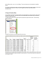
To export select a trip in the saved trip list and press the right mouse button. The following
menu will appear:
Imported into Excel the recorded data will look like this:
Among date, time and position the additional information height, speed and course will be listed.
Please consider that the speed is stated in meter per hour, to convert into km/h the value must
be divided by 1000.
CatLog User Manual - Page 13 of 14