1
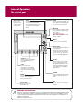
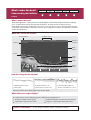
What can I see?
FIND
SHIP CURSOR
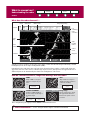
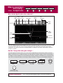
Understanding the chart
GOTO
ROUTES
TRACKS
PRESENTATION
Card 5
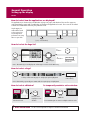
What can I use the chart for?
Find where you are.
Interpret your surroundings.
Place waypoints at specific locations.
Navigate to a specific point.
Monitor where you are going.
Record where you have been.
Measure the distance between two points.
Chart
range
Chart
orientation
4nm
North-Up
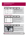
Build and follow routes.
Manage and edit routes and tracks.
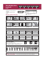
Distinguish between fixed & moving objects
(radar overlay).
View photographs of ports and marinas.
View information normally contained in an almanac.
Display an aerial photo overlay.
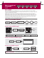
Motion
mode
Chart
view
(Relative Motion)
Local
Status bar
Chart boundary
Gully Ridge
Route
Portside
Cursor
Port point
Creek point
Waypoint
Active waypoint
Current position
Cartographic object
Track
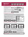
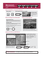
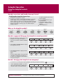
How do I move around the chart?
To change the scale:
OUT
RANGE
IN
To pan the chart:
Press RANGE (OUT) to see a larger
area of the chart.
Press RANGE (IN) to see a smaller
area in more detail.
Moves cursor. When cursor reaches
window edge, chart pans to a
different area.
Press and hold to pan larger areas.
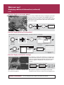
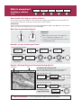
How do I find where I am on the chart?
? More information...
See 'Using the Chart' chapter of the E-Series Reference Manual
D8978_2
The boat symbol
indicates your
position.
If you cannot find your boat symbol :
The screen automatically pans to your
boat's position and re-activiates the motion
FIND
mode (see below - 'How do I change how
SHIP CURSOR
my boat moves on the chart').