1
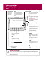
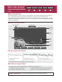
What can I see?
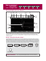
Displaying additional information
Card 7
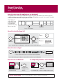
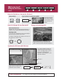
Viewing object information
OK
More detailed information for
selected object displayed.
Move cursor over object, to
display basic information.
You can now:
Locate the nearest waypoint, port, port service,
tidal and current stations, wreck or obstruction, to
the selected position.
View detailed data for the selected port, tidal or
current station.
View panoramic photographs (dependent on the
type of chart card in use)
Search for a named port.
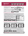
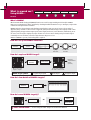
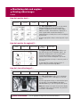
Finding nearby features and services:
1.
OK
FIND NEAREST...
Move cursor to
required position
SELECT PORT
FIND NEAREST...
2.
SELECT PORT
WAYPOINTS
PORTS
PORT SERVICES
TIDE STATIONS
CURRENT STATIONS
WRECKS
OBSTRUCTIONS
FIND
Select required
category
16 nearest to cursor in selected
category displayed.
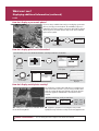
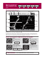
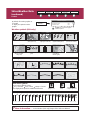
Displaying port services:
OBJECT INFO
RAINBOW MARINA
Photos
Pilot Book
OK
Select appropriate
port symbol
Position
29058'.147N
093052'.215W
Utilities
Banks
Restaurants-Bars
Supplies
Hookups
Fuel
SEARCH BY NAME
Or
Note:
Alternatively you can search
for port by name
Services for selected port displayed
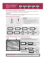
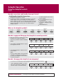
Displaying tidal and current details:
TIDE DATA
OBJECT INFO
MILE POINT Position 30006'.700N
84012'.700W
Or
T
OK
Ebb
Flood
Ebb
Flood
05:41AM
01:08AM
06:17AM
11:30AM
+187.0
+358.0
+0.0
+358.0
Current information
displayed
? More information...
0.5kt
0.2kt
0.0kt
0.2kt
Or
CURRENT DATA
Graph page displayed
See the 'Using the Chart' chapter of the Reference Manual.
D8849_2
C