1
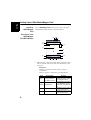
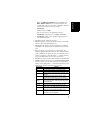
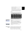
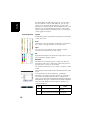
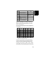
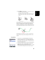
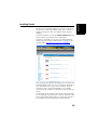
English
But unlike Map jobs, DXF jobs cannot use or re-use layers
that are external to the job. With DXF jobs, you can only
create one or more new layers within the job, right after
defining the coordinate system. Another difference lies in the
absence of an assumed feature geometry in a layer, which
means all types of features, whether points, lines or polygons,
can be logged in the layer.
Layer Properties
Symbol
57 different symbols are available to represent a point feature
on the map screen.
Color
15 different colors are available to represent a line feature or
the contour of a polygon feature on the map screen.
Style
The line style (thin, medium, thick or dash) is used to
represent a line feature on the map screen.
Fill
Eight different patterns are used on the map screen to fill the
area covered by a polygon feature.
Attributes
Attributes are an important part of a layer since they are
designed to hold specific information (other than position)
that you want to collect for each feature.
The number of attributes you can create in a layer is limited
to 50.
Each attribute is defined by a name (10 characters max.) and
a type.
You may decide to make an attribute a “mandatory”
parameter to describe any feature you will log in the layer.
This means the operator won’t be able to complete the
logging of a feature until the mandatory attribute has properly
been defined. Any type of attribute may be made mandatory.
There are eight different attribute types of attributes, as
summarized below.
Attribute
Type
Text
Menu
18
Additional Information
Needed
Maximum number of
Entering comment, etc.
characters.
Choosing an option (menu item) that
All possible menu items
suits the attribute for the visited feature. for this attribute.
Purpose