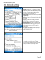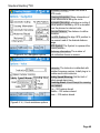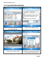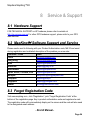
1
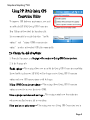
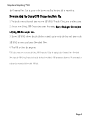
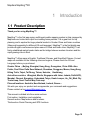
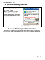
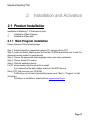
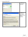
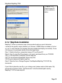
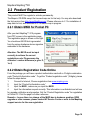
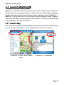
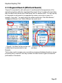
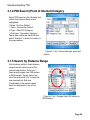
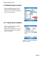
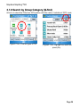
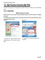
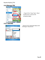
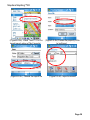
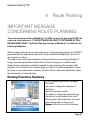
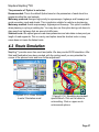
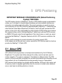
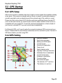
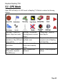
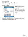
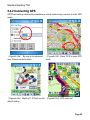
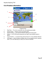
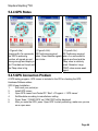
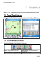
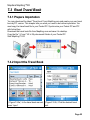
Using GPS Locate Getting Acquainted Your HP iPAQ includes Global Positioning System (GPS) Navigation technology; therefore it is capable of using GPS software applications that are compatible with this device. The GPS technology on your HP iPAQ is based on a worldwide system of GPS satellites orbiting the earth that continuously transmit digital radio signals. These radio signals contain data on the satellites' locations and their exact clock time and are used to determine your location on the earth. With your GPS capable device, you can use navigation software from other third-party companies. For GPS navigation solutions recommended by HP, visit www.hp.com/go/gpsnavigation. However, before you purchase, download or install any GPS software, you must determine that the application is compatible with this device. Check with the GPS software supplier to see if their software is compatible with the HP iPAQ hw6500 Mobile Messenger series. Setting Up Your HP iPAQ First follow the instructions in the printed Getting Started document until you complete creating a MapAsia MapKing™3D partnership with your personal computer. This includes installing the Subscriber Identity Module (SIM) and battery, synchronizing your HP iPAQ you're your personal computer, and establishing a partnership. Setting Up Internet Access on Your HP iPAQ Now that you have completed the steps in the Getting Started document, verify you have Internet access on your HP iPAQ by visiting a web site such as www.google.com or www.yahoo.com . If you cannot access the Internet, take your HP iPAQ out of the cradle and use a GPRS connection. Page 1 MapAsia MapKing™3D Using HP iPAQ Quick GPS Connection Utility To improve GPS hardware performance, you need to enable the HP iPAQ Quick GPS Connection Data Utility and download the latest data file. It is recommended to set the default to “enable updates" and “initiate GPRS connection for update" in order to download GPS file automatically. To Change the default settings: 1. From the Start menu, tap Settings > Connections > Quick GPS Connection icon. 2. In the Settings tab: Enable updates—This setting allows you to enable the Quick GPS Connection capability. If you disable it, then your HP iPAQ will no longer receive Quick GPS Connection updates and your GPS start-up times could be longer. Initiate GPRS Connection for updates—This setting allows Quick GPS Connection updates to your device over the air via GPRS. Show expiration reminders and warnings—This setting reminds you by notification when your satellite location file is out-of-date. Show tray icon on today screen—This setting turns on a Quick GPS Connection icon in Page 2 MapAsia MapKing™3D the Command bar. It is in green color if your satellite location file is up-to-date. Downloading the Quick GPS Connection Data file 1. Verify the correct date and time on your HP iPAQ. Tap the Clock icon to adjust time. 2. Access your Quick GPS Connection status by tapping Start > Settings > Connections > Quick GPS Connection icon. 3. If your HP iPAQ shows that the file has expired, again verify the date and time on the HP iPAQ is correct and press Download Now. 4. Tap OK to close the program. TIP: In the future, you can access the Quick GPS Connection Utility by tapping in the Command bar > Download Now.After the GPS Quick Connection data file has been downloaded, GPS performance Improves. We recommend to set default to automatically download GPS file. Page 3 MapAsia MapKing™3D TIPS 1. Update GPS file every 48 hours manually or allow auto download 2. Auto download by “Enable Updates" & “Initiate GPRS for update" 3. Update GPS file first before using MapKing NOTE: If you are going to use GPS Navigation in your vehicle for an extended period of time, connect your HP iPAQ to an Auto adapter to save battery power. If you don't have an Auto adapter, you can order one at http://www.hp.com/apac/ipaq/accessories GPS Technical Support and Service FOR TECHNICAL SUPPORT on HP iPAQ Quick GPS Utility: Please refer to website at http://ap.compaq.com.sg Page 4 MapAsia MapKing™3D MapKing™ G10 English version user Manual Strictly for Bundle with HP Pocket PC © 2002-2006, MapAsia.com Limited Page 5 MapAsia MapKing™3D Index Index ..................................................................................................................... 6 Copyright and Logo............................................................................................. 8 1 Introduction................................................................................................ 10 1.1 Product Description .......................................................................... 10 1.2 Software and Map Version................................................................ 11 1.3 MapKing™ G10Features ................................................................... 12 2 Installation and Activation ........................................................................ 13 2.1 Product Installation ........................................................................... 13 2.1.1 Main Program installation....................................................... 13 2.1.2 Map Data Installation.............................................................. 15 2.2 Product Registration ......................................................................... 16 2.2.1 Obtain MKID for Pocket PC........................................................ 16 2.2.2 Obtain Registration Code Online................................................ 16 2.3 Launch MapKing™ ............................................................................ 17 2.3.1 Switch Map ................................................................................. 17 2.3.2 Close Map .............................................................................. 18 2.4 Remove MapKing™ G10 ................................................................... 18 2.5 Product Upgrade ............................................................................... 18 3 Basic Functions......................................................................................... 19 3.1 Search Functions .............................................................................. 21 3.1.1 Search Startup............................................................................ 21 3.1.2 Index Search (by alphanumerical order) .................................... 22 3.1.3 Keyword Search (Wild Card Search) ......................................... 23 3.1.4 POI Search (Point of Interest) Category..................................... 24 3.1.5 Search by Distance Range......................................................... 24 3.1.6 District Centre Location .............................................................. 25 3.1.7 Search by Co-ordinates ......................................................... 25 3.1.8 Search by Group Category (Q-find) ........................................... 26 3.2 My Favorite Function (My POI)......................................................... 27 3.2.1. Build POI ................................................................................... 27 3.2.2 Manage POI ............................................................................... 28 3.2.3 Edit POI .................................................................................. 28 3.2.4 Import/Export POI....................................................................... 29 4 Route Planning .......................................................................................... 31 Routing Functions Summary ............................................................... 31 4.1 Routing planning ................................................................................. 33 Page 6 MapAsia MapKing™3D 5 6 7 8 4.1.1 Create Start/ Destination (Routing points) .................................. 33 4.1.2 Enter Route Planning Page........................................................ 34 4.1.3 Get the Result ............................................................................ 35 4.1.4 Adjust the Route ......................................................................... 36 4.2 Route Simulation............................................................................... 37 GPS Positioning ........................................................................................ 38 5.1 About GPS ......................................................................................... 38 5.2 GPS Startup ....................................................................................... 39 5.2.1 GPS Setup ................................................................................. 39 5.2.2 GPS Setting................................................................................ 39 5.3 GPS Mode .......................................................................................... 40 5.4 GPS Setting / Track Record.............................................................. 41 5.4.1 GPS Setting................................................................................ 41 5.4.2 Connecting GPS......................................................................... 42 5.4.3 Position Information.................................................................... 43 5.4.4 GPS Status ................................................................................. 44 5.4.5 GPS Connection Problem .......................................................... 44 System Options ......................................................................................... 46 6.1 Enter System Options ....................................................................... 46 6.2 General setting .................................................................................. 47 6.3 Road Sign........................................................................................... 50 Travel Book ................................................................................................ 51 7.1 Travel Book Startup........................................................................... 51 7.2 Travel Book Functions ...................................................................... 51 7.3 Read Travel Book .............................................................................. 52 7.3.1 Prepare Importation.................................................................... 52 7.3.2 Import the Travel Book ............................................................... 52 7.3.3 Travel Book Record Details ........................................................ 53 Service & Support ..................................................................................... 54 8.1 Hardware Support ............................................................................. 54 8.2 MapKing™ Software Support and Service...................................... 54 8.3 Forget Registration Code ................................................................. 54 Page 7 MapAsia MapKing™3D Copyright and Logo All title, ownership, derivative works and copyrights in the SOFTWARE are owned by MapAsia and incorporated suppliers. No right, title or interest in or to any trademark, logo or trade name of MapAsia or incorporated suppliers is granted under this AGREEMENT. The Logo of MapAsia and MapKing is owned by City Country Consultancy Limited. Copyright of the GIS Database is owned by MapAsia.com Limited and Data partners’ that have come to contract with and be specified by MapAsia.com Copyright of India Map Data is owned by Eicher Goodearth Ltd. Copyright of Indonesia Map Data is owned by PT. Duta Astakona Girinda Copyright of Japan Map Data is owned by Alps Mapping Co., Ltd. Copyright of Malaysia Map Data is owned by Geoinfo Services Sdn. Bhd. Copyright of Philippine Map Data is owned by GIS Aranet Inc. Copyright of Taiwan Map Data is owned or represented by Maction Technologies, Inc. Copyright of Thailand Map Data is owned by. Lotus Consulting International Co Ltd All other GIS Database is owned or represented by the MapAsia.com. SOFTWARE PRODUCT LICENSE The SOFTWARE is protected by local, international copyright laws and other intellectual property laws treaties. MapKing™ is the registered logo and or logo of MapAsia.com Limited in the United States of American and other countries MapAsia is the registered logo and or logo of MapAsia.com Limited in the United States of American other countries Microsoft is the registered logo and or logo of Microsoft Corporation in the United States of American other countries Pocket Outlook® is the registered logo and or logo of Microsoft Corporation in the United States of American other countries Other undeclared LOGO and Licenses belong to the owner of the copyright owner Copyright © 2001-2006, MapAsia.com Limited City Country Consultancy Limited Page 8 MapAsia MapKing™3D Important Message IMPORTANT MESSAGE CONCERNING THE USE OF MAPKING™ BY VEHICLE DRIVER TO ENSURE SAFETY DRIVING, WE STRONGLY ADVISE THAT A DRIVER SHOULD NOT OPERATE MAPKING™ WHILE DRIVING THE VEHICLE SIMULTANEOULSY. A DRIVER SHOULD NEVER FOCUS HIS OR HER ATTENTION ON THE MAPKING™ DISPLAY WHILE DRIVING. In case MapKing™ needs to be used inside a vehicle, we suggest that it should be operated by a passenger other than the driver or the driver should stop the vehicle at a convenient spot before starting to use MapKing™. IMPORTANT MESSAGE CONCERNING ROUTE PLANNING The route planning function of MapKing™ is ONLY meant to be and should ONLY be used as a crude reference. IT SHOULD NEVER BE USED TO DETERMINE ACTUAL DRIVING DIRECTIONS. The Route Planning function of MapKing™ is subject to the following limitations : - Whilst we have taken great care and endeavours in developing the product, we CANNOT guarantee that the road network data and routing calculations of MapKing™ are free of any omission or defect. -The road network and traffic conditions in the real world are ever changing, MapKing™ being a pre-packaged product cannot reflect all these changes on a constant basis. -Road network parameters specifically required for route planning, like one-way traffic indicator or turn restrictions at street crossing, are difficult or almost impossible to obtain for China or some other Asian countries. The lack of these data would significantly affect the performance of route planning. IMPORTANT MESSAGE CONCERNING GPS TRACKING The GPS tracking function of MapKing™ works on GPS satellite signals broadcasted for civilian use. It is subject to inherent signal deviations and environmental interferences caused by surroundings and bad weather. We cannot guarantee nor specify a precise level of accuracy for the GPS positioning data displayed by MapKing™. It should also be noted that the Unites States Department of Defence, who builds and operates the GPS system, is free to turn off or down-grade the civilian signals of GPS during rare occasions like regional military conflict. Although MapKing™ should work with most GPS receivers on NMEA0183 signal output format regardless of their brand name or model; we cannot guarantee that MapKing™ integrates flawlessly with ALL GPS receivers available in the market. Page 9 MapAsia MapKing™3D 1 Introduction 1.1 Product Description Thank you for using MapKing™! MapKing™ is the first pan-region multilingual mobile mapping system in Asia managed by MapAsia.com Limited with input from leading Asian partners. It is a great tool for trip planning and to explore the huge potential market in Greater China and Asian countries (Maps sold separately for different OS and language). MapKing™ is the first digital map provides English road name and place name in China and Asian cities. MapKing™ has firmly established market leader status as the bridge between western travelers and the rapid growing cities in East. MapKing™ offers maps in English, Traditional Chinese, and Simplified Chinese. Current maps are available for the following cities and regions, Please check the OS and Language before you purchased Greater China :Beijing, Shanghai, Hong Kong, Guangzhou, China 2300 cities Points, Pearl River Delta Road Network, Shenzhen, Dongguan, Macau, Hong Kong Hiking Trails, Taipei, TaiChung, Tainan, Hsinchu, KaoHsiung Asia cities countries :Bangkok, Manila, Singapore with Johor, Jakarta, Delhi-NCR, , Mumbai, Chennai, Bangalore, Hyderabad, Tokyo, Kuala Lumpur, Ho_Chi_Minh City Tourist map, Seoul Tourist Map, Asia map Planned locations: Australia, New Zealand, Iceland; Greece… We wish you enjoy our product and we appreciate your comments and suggestions. Please contact us by [email protected]. This manual is divided into three main sections: First section: Installation and registration. Second section: Map features and functions Third section: Route Planning and GPS functions Page 10 MapAsia MapKing™3D 1.2 Software and Map Version Product name: MapKing™ G10 Software and Map version information refer to ‘Tools’ >’About’ MapKing™ offers maps in English, Traditional Chinese, and Simplified Chinese. Maps of different location with different language and different platform are separate products 《Figure1-2-1a》The version information All products MUST be registered for permanent use. The Maps in CD-ROM except the licensed map are for trial only. Pocket PC map has 3 days trial period; SmartPhone map has 15 days for trial and PC map has 5 days for trial. Page 11 MapAsia MapKing™3D 1.3 MapKing™ G10Features Main Features z z z z z z z z z z z z High quality digital maps with latest map database Multiple Platforms : PC/ Pocket PC / Smartphone 2D/ 3D Navigation . GPS global satellite positioning function Route Planning Real-Time Tracking of GPS position Intelligent Voice Assiatance Track Log Export Multiple search modes Query by index/ Query by category/ Query by position Query by area/ Query by coordinates User-defined view point System Requirement z z z z z z Pocket PC 2003 or above For Chinese Map, OS must support Chinese display Minimum 32 MB RAM 8M hard disk space required 64MB storage card is recommended The PC MUST have Microsoft ActiveSync 3.7.1 or above Platform z PC OS: Windows 98/Me/XP/2000 z PocketPC OS:Pocket PC/2000/2002/2003, Windows Mobile 5.0 z CPU: StrongARM/XScale/MIPS/SH3 z RAM: 32MB(Support Storage Card) Support GPS: z RS-232/CF/PCMCIA/Bluetooth/USB/ Build-in GPS z NMEA0183 Output Page 12 MapAsia MapKing™3D 2 Installation and Activation 2.1 Product Installation Installation of MapKing™ G10included 2 parts: 1. Installation of Main Program 2. Installation of Map data 2.1.1 Main Program installation Please reference to the following steps: Step 1: Enable ActiveSync connection between PC and your device PPC Step 2: Locate the Setup_MapKing.exe file from the CD-ROM and double click to start. For download version please run setup directly. Step 3: Choose the appropriate map language version your have purchased. Step 4: Choose Pocket PC version. Step 5: Click the installation button For PC simply double-click the set up file to install If you cannot find the path, please search out the EXE files e.g. Setup_PPC_MK.exe from your CD-ROM If ActiveSync do not start automatically please press “Start”-> “Program” to start ActiveSync ActiveSync is available to download from www.microsoft.com Page 13 MapAsia MapKing™3D 《Figure2-1-1a》 Peer with PC by Active sync 《Figure2-1-1b》 Press ‘Yes’ to continue if you agree the End User License agreement. Page 14 MapAsia MapKing™3D 《Figure2-1-1c》 Check Pocket PC for the installation status. 2.1.2 Map Data Installation MapKing™ offers an extensive range of map products and we cannot determine i n advance the specific map(s) chosen by a customer. A DEMO Map is included in the”set up .exe” to verify that the core program has been installed and display successfully. To use a full map you’ve purchased, please follow the steps below: Step 1: Enable ActiveSync connection between PC and Pocket PC Step 2: Copy the map file (File extension .mk) you’ve purchased from your CD-ROM. XXX_TC.mk represents Traditional Chinese map files XXX_SC.mk represents Simplified Chinese map files XXX_Eng.mk represents English map files Step 3: Paste the file to \Storage\Program Files\MapAsia\MapKing™G10 OR \My documents If you’d like to place the map file in your storage card, please create a folder name ‘My documents’ and place it there. “My Documents” is the fixed default path used by MapKing™ G10 to locate map file. Page 15 MapAsia MapKing™3D 2.2 Product Registration This product MUST be register to activate permanently. The Maps in CD-ROM except the licensed map are for trial only. You may also download the trial version from http://www.MapKing.com/. Please reference to 2.1 for installation of map data for trial, and reference to 2.3 to switch map in program. 2.2.1 Obtain MKID for Pocket PC After you start MapKing™ G10 program from PPC screen is the registration page. The registration page is shown on the right. You should see MK ID that is generated from the unique hardware device signature embedded in the hardware. Attention: The MK ID must be input correctly to achieve the correct registration code. Please aware the character / number difference (e.g.0or O, 1or I) 2.2.2 Obtain Registration Code Online From the package you will have a product authorization card with a 10 digits combination code “Product Authorization code” .To get the “Product registration code” (16digits), please follow the steps below: 1. Connect to Internet, Choose registration from www.mapking.com 2. Input the “Product Authorization code” 3. Input the MKID , make sure you input the MKID 4. Input the information request correctly. This information is confidential and will use for upgrade notification and promotion. Get the “Product Registration code” for registration in Pocket PC. Print the page for further reference. Remarks : In case there is a change of the MKID due to hardware problem, ROM upgrade or other reasons, please contact HP Service Centre or write to the Mapking support service for the new registration Page 16 MapAsia MapKing™3D 2.3 Launch MapKing MapKing is launched in the similar way like other software installed in your Pocket PC. Tap the start-up icon at the upper left corner of the screen, you should find the MapKing program icon within the upper row of the pop-up menu, tap again to launch MapKing. If MapKing does not show up in the list of recently launched programs, select ”programs” in the menu will open another listing all programs installed in your PPC and you could then launch MapKing from this second Menu 2.3.1 Switch Map User may have more than one map installed, select”Tools> Switch Map” would bring up a list of all the maps; simply tap on any item within the list to switch to a new map. . 《Figure2-3-1a》Press ‘Tools >’Switch Map’ 《Figure2-3-1b》Press select Page 17 MapAsia MapKing™3D 《Figure2-3-1c》Map Switched 2.3.2 Close Map Press ‘Tool’>’Close Map’ to close MapKing™ G10. Please be reminded that ‘MapKing™” will run on the background if you do not exit the program, which occupied resource of your device. 2.4 Remove MapKing™ G10 Follow steps below to remove / uninstall MapKing™ G10Program. 1. Press ‘Tool’ > ‘Close Map’ to close MapKing™ G10. 2. Press ‘Start’ >’Setting’ > ‘System’ > ‘Remove Program’ 2.5 Product Upgrade The license allows end user to register ONLY ONE MAP out of the allowed maps as it is. End user might need to purchase product upgrade. Registered user will receive our News via email. Visit www.mapking.com for more information. Please read the briefing before you download the latest update. Page 18 MapAsia MapKing™3D 3 Basic Functions Basic operation Main-Menu The description of Main Menu options Switch Map: Close the current map and switch to another. File: To import/export ‘My Favourite’ Style: Day/Night Mode More: Enter the advanced functions, Search mode, Routing page, My Favourite and Travel book functions. Options: System setting. GPS/ Track: GPS setting and track management. Help: Legends category and current map information. About: License and copyright announcement. Tap-And-Hold-Menu on map to call the sub-menu My Favourite Home Remove My Favourite Add as Start Add as End Remove Routing Simulate Add the stroke to ‘My Favourite’ Set the stroke to ‘My Home’ Remove the self define POI from map if any. Set as starting point Set as destination Remove Start/End if any. after Start/ End have been setup After routing result achieved you may press simulate to start simulation in GPS mode. Page 19 MapAsia MapKing™3D Page 20 MapAsia MapKing™3D 3.1 Search Functions MapKing™ G10search functions included: Index, Keyword, Position, Area, Long/Lat, Crossing etc. Press the index of pages to switch different search functions. 3.1.1 Search Startup You may start search page in two ways: 《Figure3-1-1a》Press ‘Tools’ > ‘More’ > ‘Find’ to enter the search page. 《Figure3-1-1b》Or click the binoculars icon. Page 21 MapAsia MapKing™3D 3.1.2 Index Search (by alphanumerical order) This search mode is equivalent to browsing a dictionary or directory organized in alphabetical order. Enter any alphanumerical string and all records with the first X characters of their name matching the input text string will be listed as the search result. The following picture shows the result of index search using “Gr” as input string. 《Figure3-1-2a》List all the result begin with “Grace”, non case-sensitive. 《Figure3-1-2b》Obtain the result by defined area and nature of POIs. 《Figure3-1-2c》Tap and Hold to call the submenu for further action. Page 22 MapAsia MapKing™3D 3.1.3 Keyword Search (Wild Card Search) “Keyword” is equivalent to wild card search. It would search for the appearance of the input string anywhere within the name field of the record. If “mer” is used as the input sting, then the search result would show “Bukit Merah” and “Le Meriden Hotel”. You can input up to 5 keywords in each search to be separated by comma, semi-colon or space. For example, if you enter “” as search string, the system would return “Kim Wee Mansion”, “Wedgewood Mansion” and “Welkin Mansion” as search result. 《Figure3-1-3a》Enter the Key word as ‘mer’ 《Figure3-1-3b》Tap-and-Hold to call the sub menu to show that all records relate to ‘mer’ Remarks: This function used to compare every record from compressed database therefore a longer processing time is required. User may condition the search area or type to increase the performance of this search. Page 23 MapAsia MapKing™3D 3.1.4 POI Search (Point of Interest) Category Select POI based on the following four criteria from the pull-down menu highlighted : -0 Area : First-tier District -1 Town : Second-tier District -2 Type : Main POI Category -3 Sub-type : Secondary Category Tap an item within the result list and select “Position” to show its location in the map window. 《Figure3-1-4a》Choose the type, area and district. 3.1.5 Search by Distance Range Find locations within a fixed distance range from the center point of the current map window. There are 7 fixed search ranges from 100 meters to 2500 meters. Tap an item in the result list and select “Go” to have the map zoomed into that item. Coordinates of the search center point are displayed on top of the menu. 《Figure3-1-5a》Ranges from 100 meters to 2500 meters. Page 24 MapAsia MapKing™3D 3.1.6 District Centre Location Select a main district from the “City List” and then a secondary district from the “Town List”, tap “Go” to locate the selected district in the map window. 3.1.7 Search by Co-ordinates Enter the longitude latitude coordinates either in decimal format or degree-minute-second format, hit the “Go” button and the map will be re-centered to the input coordinates 《Figure3-1-7a》Enter the longitude latitude coordinates. Page 25 MapAsia MapKing™3D 3.1.8 Search by Group Category (Q-find) Q-find is to check the POIs from GPS position with 2km radius. Available at ‘GPS’ mode. Figure3-1-8a》Pick the types of POI. 《Figure3-1-8b》Highlight the result and press (Go). Page 26 MapAsia MapKing™3D 3.2 My Favorite Function (My POI) “My POI” lets you place and manage self-created POI (Point of interest) in an overlaid map layer. 3.2.1. Build POI Build records in 2 ways Build from the current map: Tap and Hold the position to call the submenu, ‘Add My favourite’ From Search result: Use any search method to search a POI, Tap and Hold the result and press ‘My Favourite’ Method 1 Method 2 《Figure3-2-1a》Tap and Hold on main map and press ‘My Favourite’ to add POIs 《Figure3-2-1b》Press ‘My Favourite’ to build POI Page 27 MapAsia MapKing™3D 3.2.2 Manage POI 《Figure3-2-2a》Press ‘Tools’> ‘More’> ‘My Favourite’ to enter the POI management page. 3.2.3 Edit POI 《Figure3-2-3a》Choose the display mode or the type of ‘My favourite’. Page 28 MapAsia MapKing™3D 《Figure3-2-3b》Tap-and-hold POI for sub menu options of the POI 《Figure3-2-3c》Press ‘edit’ to edit the contents of POI. The ‘Alarm’checkbox is a reminder if your route is close to ‘My favourite’ POI. 3.2.4 Import/Export POI After POI database build up, user may need to backup the POIs or share with friends. Use the Import/ Export functions to do it. Page 29 MapAsia MapKing™3D 《Figure3-2-4a》Press ‘Tools’-> ‘File’ for 《Figure3-2-4b》Choose the property of file to be Export. import/export option of ‘My Favourite’. 《Figure3-2-4c》Choose the import file 《Figure3-2-4d》Import succeed! Page 30 MapAsia MapKing™3D 4 Route Planning IMPORTANT MESSAGE CONCERNING ROUTE PLANNING: The route planning function of MapKing™ is ONLY meant to be and should ONLY be used as a crude reference. IT SHOULD NEVER BE USED TO DETERMINE ACTUAL DRIVING DIRECTIONS. The Route Planning function of MapKing™ is subject to the following limitations: Whilst we have taken great care and endeavours in developing the product, we CANNOT guarantee that the road network data and routing calculations of MapKing™ are free of any omission or defect. The road network and traffic conditions in the real world are ever changing; MapKing™ being a pre-packaged product cannot reflect all these changes on a constant basis. Road network parameters specifically required for route planning, like one-way traffic indicator or turn restrictions at street crossing, are difficult or almost impossible to obtain for China or some other Asian countries. The lack of these data would significantly affect the performance of route planning. Routing Functions Summary There’re several options you can adjust the results. use arrow to change the sequence of destination use bin to eliminate section Use option to change the preferably type. Use avoid to avoid roads in from result. Routing result. After adjustment you must press routing again to achieve the Browser turn by turn result by Summary. change. Page 31 MapAsia MapKing™3D Page 32 MapAsia MapKing™3D 4.1 Routing planning 4.1.1 Create Start/ Destination (Routing points) To initiate route planning, at least 2 routing points (Start, Stop, and End) must be assigned. Tap at the precise spot and select “Routing” to add a routing point (Start / End / Stop), select “Remove Stop” to delete a routing point. MapKing™ supports up to a total of 9 routing points. It should be noted that Route Planning is calculated from the embedded road network data. Accordingly, the routing points should be placed either on top of or very close to the street lines. There’re 3 ways to setup routing point 《Figure4-1-1a》Search on Main MapTap and Hold the file and choose ‘Add as Start’ option at sub-menu. 《Figure4-1-1b》In ‘My Favourite’ page, Tap and Hold the POI and choose the option at sub-menu. 《Figure4-1-1c》From search result, Tap and Hold the POI and choose the option at sub-menu. Page 33 MapAsia MapKing™3D 4.1.2 Enter Route Planning Page Once you have 2 or more routing point, you can start the route planning. You have 2 ways to enter routing page. 《Figure4-1-2a》Set up 2 Routing points. 《Figure4-1-2b》Press ‘Tools’ > ‘More’> ‘Routing’ or press the ‘Flag by Car’ Button in the function bar. Page 34 MapAsia MapKing™3D 4.1.3 Get the Result In Routing planning page press ‘Routing’ to achieve the result. 《Figure4-1-3a》Press ‘Routing’ , the total distance and calculation cost will be display. 《Figure4-1-3b》Press ‘ok’ to exit. The recommend path will be highlight on map. 《Figure4-1-3c》Turn-by-turn result will be display if you press ‘Summary’ Page 35 MapAsia MapKing™3D 4.1.4 Adjust the Route There’re several options you can adjust the results. 1. by adjust the sequence of destination 2. by eliminate section 3. by calculate condition Change the sequence of destination. Press Routing again to achieve the result. Press ‘Avoid’ to enter the avoid list of section. Press the list box of ‘option’ to avoid specific types of road. You must Press ‘Routing’ again to achieve new result. 《Figure4-1-4a》 Change the sequence to destinations. Press Routing again to achieve the result. 《Figure4-1-4b》Pick avoid section 《Figure4-1-4c》Pick preferred path. Page 36 MapAsia MapKing™3D The parameter of ‘Option’ is as below. Recommended: This is the default Option based on the parameters of each street line segments within the road network. Motorway preferred: Assigns high priority to expressways, highways and freeways and avoid secondary roads and streets. This is particular suitable for vehicle route planning. Motorway avoided: Avoids expressways, highways and freeways. This option is suitable when planning a cycling or walking trip. You may also use this option during rush hours to stay away from highways that are prone to traffic jams. Shortest route: this option Ignores road class parameters and calculates routes purely on length of road segments. This is a rarely used option since the shortest route in many cases does not mean the fastest route. 4.2 Route Simulation MapKing™ provides more than result and paths. We also provide 2D/3D simulation. After Start and Destination have been created, with the routing result you may simulate the course of the planned route and have further adjustment. 《Figure4-2-1a》Press ‘Simulate’ to enter ‘Simulation mode’ 《Figure4-2-1b》Simulating by standard speed 85km/h. Click on the center to enter setting. Click on upper row to enter search options. Page 37 MapAsia MapKing™3D 5 GPS Positioning IMPORTANT MESSAGE CONCERNING GPS (Global Positioning System) TRACKING The GPS tracking function of MapKing™ works on GPS satellite signals broadcasted for civilian use. It is subject to inherent signal deviations and environmental interferences caused by surroundings and bad weather. We cannot guarantee nor specify a precise level of accuracy for the GPS positioning data displayed by MapKing™. It should also be noted that the Unites States Department of Defence, who builds and operates the GPS system, is free to turn off or downgrade the civilian signals of GPS during rare occasions like regional military conflict. Although MapKing™ should work with most GPS receivers on NMEA0183 signal output format regardless of their brand name or model; we cannot guarantee that MapKing™ integrates flawlessly with ALL GPS receivers available in the market. Please read the package for product information for product support GPS. In this chapter we will discuss how to setup, operate the GPS functions and the functions provides by MapKing™ G10with GPS. 5.1 About GPS GPS (Global Positioning System) is developed and maintained by the US Defence Department. The system was initially deployed for military use but was later open for civilian navigation. The system comprises of 24 satellites on different orbits. The GPS receiver on the ground picks up signals from at least three satellites and calculates its real time position by a set of mathematical formulas generally known as “triangulation”. GPS receivers must maintain line-of-sight with the satellites. GPS won’t work indoor and its accuracy tends to degrade significantly when the receiver is located under sheltered area or near high-rise building structure or terrain. Page 38 MapAsia MapKing™3D 5.2 GPS Startup 5.2.1 GPS Setup GPS receiver needs to establish clear line of sight to receive signals from satellites orbiting in the space. If the receiver is placed inside a vehicle or vessel, an extended antenna is normally required to pick up signals beyond the enclosed area of the vehicle or vessel. Please note that various types of I/O interface exist among different types of pocket PC (even for the same brand), you should ensure that the output interface of the receiver is compatible with your pocket PC. Consult the technical specifications or device dealer of your receiver or pocket PC if you are in doubt about compatibility. For Bluetooth GPS, you’ll need to setup the connection between GPS receiver and your Device. Please follow the manufacturer instructions and be reminded to press ‘Connect’ of GPS device before you start using GPS. 5.2.2 GPS Setting 01. 02. 03. 04. 05. 06. 07. 08. 09. 10. 11. 12. 13. 14. 15. Next turn indicator Next intercross name Battery and GPS status Current speed Direction of destination Zoom in/out Switch display mode Highway Crossing information Estimated time to destination Current street name Distance to destination Current position Recommended path The indicator of 2nd next turn The distance to next turn Page 39 MapAsia MapKing™3D 5.3 GPS Mode Open GPS will lead you to ‘GPS mode’ in MapKing™ G10which contains the following displays. Rerouting--- Activate the Rerouting based on actual position Destination--- Change your Day/Night--- Switch destination or Stop GPS and Day/Night mode routing options. GPS Status--- View the GPS Voice Command--- this signal status function was temporary disable. M.O.B.--- Mark the point of Mute--- Disable vocal GPS position, only work assistance when GPS is on. Close Map--- Close GPS, switch to ‘Map View’ mode Change Map--- Switch to other Map file. Compass mode--- Enter compass mode of MapKing to the direction Exit--- Close MapKing™ G10 Setting--- Enter the general setting. Page 40 MapAsia MapKing™3D 5.4 GPS Setting / Track Record 5.4.1 GPS Setting Disable--- stop any track playing or GPS real-time tracking. Auto-detect--- can detect most brands of GPS in the market. By User--- user select, For hw6515/ 6965 build in GPS the default setting can only be COM7, baudrate 57600 Track--- Open, Save and replay the track records. 《Figure5-4-1a》Setting page Remarks: Only Track Log files captured on live GPS signals can be saved, simulated routes generated by Route Planning cannot be saved." Page 41 MapAsia MapKing™3D 5.4.2 Connecting GPS GPS/Track setting is defined by manufacturer, which needs simply one click to enter GPS mode. 《Figure5-4-2a》 By user is for advanced user, Please use Auto detect. 《Figure5-4-2b》Press ‘GPS’ to enter GPS mode 《Figure5-4-2c》MapKing™ G10will use the 《Figure5-4-2d》GPS mode on! default setting Page 42 MapAsia MapKing™3D 5.4.3 Position Information 1 5 2 6 3 4 1. 2. 3. 4. 5. 6. 《Figure5-4-3a》 Date/Time --- The clock is accurate only until positioning succeeds. Vehicle Speed --- speed of vehicle by reading GPS. Vehicle direction --- The estimate direction heading from last position. Altitude ---for 3D GPS positioning system will need 4 good satellite signal or above. Current Position --- can be fixed only with minimum 3 or more satellites detected. GPS status --- 3 kind of status available, tick(ˇ) for successful position, question mark (?) for GPS warming up, cross (X) for GPS not available. Page 43 MapAsia MapKing™3D 5.4.4 GPS Status 《Figure5-4-4a》 Acquiring No Fix represents the GPS is achieving position, all signals are not strong enough and display in red. Time/date not tuned and the Pdop value is big. 《Figure5-4-4b》 2D Positioning acquired when 3 fixed satellite signals are in blue . 《Figure5-4-4c》 3D Positioning acquired when 4 or more satellite signals are fixed and the Pdop value is relatively small. Remarks: Large PDOP value means weak signal 5.4.5 GPS Connection Problem A GPS testing program –GPS viewer is included in the CD for checking the GPS Hardware/Software status. GPS Viewer Installation 1. Soft reset your pocket pc. 2. Install GPS viewer 3. Open GPS viewer from Pocket PC ‘Start’ ->’Program’ -> ‘GPS viewer’ 4. Set Baudrate according to manufacturer setting 5. Press ‘Scan’, ‘FOUND GPS’ on COM PORT will be displayed 6. After you scan the GPS, press ‘Open GPS’ to start positioning, make sure you are on an open area. Page 44 MapAsia MapKing™3D Normal GPS Status Press scan to scan GPS, GPS found! make sure the COM port and Baudrate is correct 3 or more good signals Acquiring =3D POS or 2D POS GPS Failure No GPS found Search again or Contact manufacturer No/ wrong GPS Status Search again or Contact manufacturer Continuous bad signal Press ‘cold start’ at GPS viewer to clear the internal memory of GPS Page 45 MapAsia MapKing™3D 6 System Options 6.1 Enter System Options There’re 2 ways to set the options of MapKing™ G10: 《Figure6-1-1a》Press ‘tools’> ‘Options’ in ‘Map view’ mode. 《Figure6-1-1b》Press ‘Options’ in ‘GPS’ mode. Page 46 MapAsia MapKing™3D 6.2 General setting 《Figure6-2-1a》General option page Unit: the unit of distances can be either in miles or kilometres. Interface: MapKing™ G10support English, Traditional Chinese and Simplified Chinese interface. Choose appropriate interface according to your hardware OS. Zoom control: The Zoom control bar position on main map. “GIS” : grid lines on the ground rotates with the screen “Camera” : grid lines on the ground are static and do not rotate with the screen Multi-turn Alarm: add ‘then’ in between the vocal instruction of the approaching turns Modify system time: use GPS time as system time. Day/ Night auto switch: Switch Day/night mode by system clock. This mode can only be use in Taiwan. You may set the update frequency and the avoiding condition of planning routine Page 47 MapAsia MapKing™3D 《Figure6-2-1b》Navigation options Automatic Scaling: Shows best scale in GPS mode. Crossing Information: Show information of street intersections along the route Automatic Rerouting: activates re-routing if actual position tracked by GPS is deviated from the planned or desired route. Reroute Distance: The distance to define deviation. Fix GPS Position: Re-align GPS position to the nearest road of the desired distance range GPS Symbol: The Symbol to represent the current position Motorway information: The number of sub-indicators shows on screen. Instructor: The Instructor is defaulted with installed language version. Install plug-in to enable more vocal instructor. Safety Speed Warning: Set the limit of safety speed alarm here. Crossing Vocal: Vocal Prompt for crossing point ahead: Far--- 500 meters ahead Middle--- 300 meters ahead Near--- 100 meters ahead 《Figure6-2-1c》Vocal assistance options Page 48 MapAsia MapKing™3D Default Setting: display all the POIs User Define: user define the POIs show on main map 《Figure6-2-1d》POI display options Page 49 MapAsia MapKing™3D 6.3 Road Sign The road sign defines in MapKing™ G10(from left to right): 《Figure 6-3-1a》Road sign summary Upper row (from left to right) Lower row (from left to right) Leaving expressway along the right lane Entering tunnel ahead Leaving expressway along the left lane Entering bridge ahead Leaving expressway Tollgate Entering expressway along the left lane Rest area Entering expressway along the right lane Interchange Entering expressway Turn left at intersection ahead Entering freeway along the left lane Turn right at intersection ahead Entering freeway along the right lane U-turn to the left at intersection ahead Entering freeway U-turn to the right at intersection ahead Stay on the right lane Stay on the left Stay on the left lane Stay on the right Entering interchange Distance to destination Entering elevated road Please set destination Page 50 MapAsia MapKing™3D 7 Travel Book MapKing™ G10™ provides a travel book log function which allows best travel schedule 7.1 Travel Book Startup Press to enter “Travel Book” main page, this function is not available in GPS mode. 《Figure7-1-1a》Press on the spot or enter the “travel book” page to 《Figure7-1-1b》Pick your spot 7.2 Travel Book Functions This chapter introduce the main functions of “travel book” Open: Import the travel book files. Details: View detail of highlighted spot Add Favourite: Add highlighted spot to ‘My favourite’ Locate: go to the spot Page 51 MapAsia MapKing™3D 7.3 Read Travel Book 7.3.1 Prepare Importation You may download the latest “Travel book” from MapKing.com and create your own travel book by PC version. This chapter tells you what you need to do before importation. You must copy the travel book file to your Pocket PC. Synchronize your Pocket PC and PC with ActiveSync. Download the travel book file from MapKing.com and save it to desktop. Copy the file *.ti1 and *.ti2 to ‘My documents’ folder of your Pocket PC Start MapKing™G10 7.3.2 Import the Travel Book 《Figure7-3-2a》In the travel book manual, 《Figure7-3-2b》Pick the desired travel press “open” book. Page 52 MapAsia MapKing™3D 7.3.3 Travel Book Record Details 《Figure7-3-3a》Highlight the Spot and press Info to enter the detail 《Figure7-3-3b》Details of record 《Figure7-3-3b》Picture of Spot 《Figure7-3-3c》You may call the sub menu for further action by tap and hold Page 53 MapAsia MapKing™3D 8 Service & Support 8.1 Hardware Support FOR TECHNICAL SUPPORT on HP hardware please refer to website at http://ap.compaq.com.sg For other GPS hardware support, please refer to your GPS manufacturer 8.2 MapKing Software Support and Service Please send e-mail to following with your Product Authorization code, MK ID and email during registration and a detailed description of the problem you encounter Countries / Cities Email [email protected] China [email protected] Hong Kong [email protected] India [email protected] Indonesia [email protected] International [email protected] Japan, Korea, Thailand, USA [email protected] Malaysia [email protected] Philippine [email protected] Singapore [email protected] Taiwan 8.3 Forget Registration Code Visit www.mapking.com , click “Registration”, pick “Forget Registration Code” at the bottom of the registration page. Key in product authorization code and registered e-mail. The registration code will be immediately display on the screen and the code will also send to the designated email address. - End of Manual Page 54