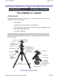
1
SYSTEMATIC NAVIGATION
EXCEL APPLICATION FOR ASTRO NAVIGATION
USER MANUAL V5.0 31-MARCH-2011
Systematic Finance plc
Orchard House
Green Lane
Guildford
Surrey GU1 2LZ
Telephone: +44 (0)1483 532929
Telefax: +44 (0)1483 538358
E-mail: [email protected]
Internet: www.sysmaps.com
31 March 2011
SFLNav50.doc Version 31-December-2010
© Systematic Navigation : www.sysmaps.com
Sflnav50.doc
Manual v5.0 31 March 2011 : Page 1
Contents
1 INTRODUCTION............................................................................................................................................................. 4
1.1 SYSTEMATIC MAPS – WWW.SYSMAPS.COM .......................................................................................................................... 5
2 INSTALLATION .............................................................................................................................................................. 7
2.1 DESCRIPTION ..................................................................................................................................................................... 7
2.2 INSTALLATION ................................................................................................................................................................... 7
2.3 PULL-DOWN MENUS .......................................................................................................................................................... 8
3 OVERVIEW ...................................................................................................................................................................... 9
3.1 GENERAL PRINCIPLES......................................................................................................................................................... 9
3.2 SYSTEMATIC NAVIGATION ................................................................................................................................................10
3.3 OVERVIEW OF SYSTEMATIC NAVIGATION ..........................................................................................................................11
3.4 GLOSSARY ........................................................................................................................................................................13
4 USING SYSTEMATIC NAVIGATION.........................................................................................................................14
4.1 METHOD ...........................................................................................................................................................................14
4.2 PROCEDURE ......................................................................................................................................................................15
5 SUN....................................................................................................................................................................................28
5.1 METHOD A - ARIES ...........................................................................................................................................................28
5.2 METHOD B - POLYNOMIAL COEFFICIENTS .........................................................................................................................29
6 STARS...............................................................................................................................................................................30
6.1 METHOD A - ALMANAC .....................................................................................................................................................30
6.2 METHOD B - POLYNOMIAL COEFFICIENTS .........................................................................................................................30
6.3 POLAR STARS....................................................................................................................................................................31
7 STAR CHARTS................................................................................................................................................................33
7.1 STAR NUMBERS ................................................................................................................................................................33
7.2 STAR FINDER ....................................................................................................................................................................34
7.3 360’ SUN, PLANETS, MOON AND STAR CHART...................................................................................................................36
8 MOON...............................................................................................................................................................................37
8.1 METHOD A - ARIES ...........................................................................................................................................................37
8.2 METHOD B - INPUT POLYNOMIAL COEFFICIENTS ...............................................................................................................37
9 PLANETS .........................................................................................................................................................................40
9.1 METHOD A - INPUT GHA AND DEC ..................................................................................................................................40
9.2 METHOD B - POLYNOMIAL COEFFICIENTS .........................................................................................................................41
10 ANNUAL ALTITUDE TABLE.....................................................................................................................................42
10.1 METHOD .........................................................................................................................................................................42
11 CORRECTED ALTITUDE...........................................................................................................................................44
11.1 METHOD .........................................................................................................................................................................44
11.2 OBSERVED ANGLE ..........................................................................................................................................................45
12 SIGHT REDUCTION....................................................................................................................................................46
12.1 METHOD .........................................................................................................................................................................46
13 CALCULATED POSITION..........................................................................................................................................47
13.1 METHOD .........................................................................................................................................................................47
13.2 EXAMPLE ........................................................................................................................................................................48
14 SUN AND MOON RISE AND SET ..............................................................................................................................51
14.1 DESCRIPTION ..................................................................................................................................................................51
14.2 EXAMPLE ........................................................................................................................................................................52
15 GREAT CIRCLE ...........................................................................................................................................................53
16 BACKGROUND DATA ................................................................................................................................................55
16.1 DESCRIPTION ...................................................................................................................................................................55
17 DATA SCHEDULES .....................................................................................................................................................58
17.1 DESCRIPTION ..................................................................................................................................................................58
18 ASTRO NAVIGATION IN BASIC ..............................................................................................................................59
18.1 BASIC FILE - ASTNAV40.BAS ..........................................................................................................................................59
18.2 PROCEDURE ....................................................................................................................................................................59
18.3 EXAMPLE ........................................................................................................................................................................59
© Systematic Navigation : www.sysmaps.com
Sflnav50.doc
Manual v5.0 31 March 2011 : Page 2
19 WORKED EXAMPLES ................................................................................................................................................61
19.1 SUN, MOON AND A STAR ON 21 JUNE 1994......................................................................................................................61
19.2 REGULUS, ANTARES AND KOCHAB ON 4 JULY 1994.........................................................................................................63
19.3 SUN, MOON AND STAR ON 19 JUNE 1991.........................................................................................................................65
19.4 VEGA, MOON AND SUN ON 15 FEBRUARY 2006 ...............................................................................................................66
19.5 MOON, STAR (18 SIRIUS) AND MARS ON 11 SEPTEMBER 2014 .........................................................................................69
20 INFORMATION ............................................................................................................................................................71
20.1 READ ME NOTES .............................................................................................................................................................71
20.2 INSTALLATION .................................................................................................................................................................73
20.3 STARTING THE APPLICATION ............................................................................................................................................73
20.4 REGISTRATION ................................................................................................................................................................74
20.5 VERSION AND FILE INFORMATION ...................................................................................................................................75
21 LICENCE TERMS AND CONDITIONS.....................................................................................................................76
22 BIBLIOGRAPHY ..........................................................................................................................................................77
© Systematic Navigation : www.sysmaps.com
Sflnav50.doc
Manual v5.0 31 March 2011 : Page 3
1 Introduction
Systematic Navigation is a Windows and Excel-based solution for astro and offshore navigation.
The object of this manual is to help you get the most out of the application. This manual provides background on the use
of Systematic Navigation and the methods used in its formulation. It also provides in a convenient form all the data you
need for astronomical navigation and sight planning.
Systematic Navigation solves all the problems of calculating hour angles declination and sight reduction and then plots
sight lines and statistical fixes for up to three sights. It is totally automated and removes the need for a pocket calculator,
almanac or sight tables and provides:
•
•
•
•
•
•
•
Position fixes from two or three sextant sights without an Almanac
Automatic calculation of hour angles, declination and sight reduction
Chart plots and full results print-outs of all angles and position lines
Stars Charts for all 59 stars giving SHA, elevation and bearing
Star Identification from angle and bearing
Schedule of positions of all celestial bodies
Sun and Moon rise and set including Sun transits
This guide does not try to teach astro navigation however it is particularly suited to students of navigation who wish to
learn the methodology. You can select calculation of hour angles and declination using:
•
•
•
Aries Corrections
Polynomial Coefficients (see Compact Data in the Bibliography)
Almanac Data - Greenwich and Sidereal Hour Angles and Declination
Knowledge of the basic theories is assumed. A bibliography is given at the end of the guide in addition to the explanations
of the formulae and algorithms used by the system.
We strongly recommend that you review each of the examples in turn with this manual and make sure that you understand
the results produced. Registration entitles you to support so please contact Alastair Day if you need help or more
information.
Systematic Navigation also produces a combined astro and coastal navigation package. This comprises three methods of
astro navigation, sun and moon rise and set, estimated position, course to steer, tidal heights, passage planning and satellite
positioning for Astra and the other television satellites.
Copyright © Systematic Finance plc 2011. All rights reserved. All intellectual contents and any derivatives or
improvements on the Systematic Navigation disk are the property of Systematic Finance plc. The programs have been
extensively tested, however, no liability whatsoever can be accepted regarding the use or accuracy of the programs and
associated data. We will make every effort to correct such software errors that are found and reported to us.
© Crown Copyright and/or database rights. Reproduced by permission of the Controller of Her Majesty’s Stationery
Office and the UK Hydrographic Office (www.ukho.gov.uk).
.
Date / Reference:
Expiry Date:
V5.0 31-March-2011
31 December 2011
Systematic Navigation is a division of Systematic Finance plc
Orchard House, Green Lane, Guildford, Surrey UK GU1 2LZ
Telephone Number:
Telefax Number:
E-mail:
Web:
+44 (0)1483 532929
+44 (0)1483 538358
[email protected]
www.system.co.uk / www.sysmaps.com
Registered Number:
VAT No:
Registered Office:
2443802
GB 572 5542 32
Orchard House, Green Lane, Guildford GU1 2LZ
© Systematic Navigation : www.sysmaps.com
Sflnav50.doc
Manual v5.0 31 March 2011 : Page 4
1.1 Systematic Maps – www.sysmaps.com
See also Systematic Maps at www.sysmaps.com for free on-line mapping provided by government and collaborative
organisations. This site offers more explanation of the astro navigation program together with a number of different maps:
•
•
•
•
•
•
•
UK Ordnance Survey topographical maps
Cloudmade open source world-wide maps
French IGN topographical maps
OpenStreetMap and German BKG topographical maps with Bing, MuliMap, Google, Yahoo, relief and other
layers
Google maps with search and StreetView window
Bing/MultiMap
Navteq with local search and routing
All the maps allow a GPS signal feed from Franson GPSGate software and are ‘location aware’ with Skyhook Loki which
positions the maps based on wiFi signals. There are also other services such as search and geocoding which provide
addresses and latitude/longitude positions. See the Information page at www.sysmaps.com for a full specification.
Specimen maps are on the next page:
•
•
•
•
UK Ordnance Survey
Cloudmade open source
French IGN
Navteq
© Systematic Navigation : www.sysmaps.com
Sflnav50.doc
Manual v5.0 31 March 2011 : Page 5
© Systematic Navigation : www.sysmaps.com
Sflnav50.doc
Manual v5.0 31 March 2011 : Page 6
2 Installation
2.1 Description
The system requires an IBM compatible computer with minimum 5.0 Mb spare hard disk capacity and sufficient RAM.
The software required is Windows and Microsoft Excel 2003 (or later).
The above will be on one disk in a compressed form or downloaded from the Internet. Install the application on a hard
disk as shown below. The text files below can be opened with any text editor and are un-formatted.
A full pack of files for Systematic Navigation could include the following in addition to the Excel file:
Description
File Name
Excel Application File
SFLNavXX.xls
Approximate Size
1,778,000
Icon File
SFLNav20.ico
766
Basic Execution File
MSBasic.com
31,744
Astro Navigation in Basic
AstNav40.bas
10,496
Registration and Read Me Icon
Help.ico
Read Me Text File
ReadMe.txt
766
6,978
2.2 Installation
(1)
Start Windows.
(2)
Insert the Systematic Navigation disk into the CD or an alternative drive.
(3)
In the Windows File Manager, choose Run from the File Menu.
(4)
Windows displays the Run dialog box.
(5)
Type a:setup in the Command Line Box (where a is the drive letter).
(6)
Choose OK.
(7)
Follow the instructions on the screen.
The system decompresses the files on the floppy disk and then sets up a program group called Systematic Navigation. It
then creates icons for the main application file (‘SFLNavXX.xls’) and the ReadMe and Registration files.
The command lines should be correct based on your answers during the set-up routine. If you experience any problems,
check the command lines to make sure Windows starts Excel or Notepad and then the application file.
Note that you can always load the file ‘manually’ when you already have Excel loaded.
To start Systematic Navigation, click the icon twice quickly to load Excel and the application. A copyright box appears.
Click 'OK' and the system displays a description of the information needed. See Section 3.2 for an overview map of the
application and Section 4 for detailed instructions.
When you first open the application, click ‘Halt’ at the description dialog box and manually tab along the sheets to the end
schedule, ‘Version’. Enter the name and code as given to you on your invoice to register the Systematic Navigation.
© Systematic Navigation : www.sysmaps.com
Sflnav50.doc
Manual v5.0 31 March 2011 : Page 7
2.3 Pull-Down Menus
The 'pull-down' menus at the top of your screen are:
Menu
Command
Action
Commands
Display Main Menu
Copy Selected Cells
Copy Results Schedule
Fill Selection Down
Fill Selection Across
Re-set All schedules
Restore Excel Menus
Save Current File with back-up
Close Application to Excel
Exit to Windows with Save Option
Display Main Menu to start inputting or revising data
Copy selected cells
Copy results to a new file
Normal fill down
Normal fill across
Set all schedules to top of page
Restore normal Excel toolbars at the top of the screen
Open save options
Close Systematic Navigation without saving it to Excel
Quit Excel and prompts for ‘save file’ options
Print
Print
Print Preview
Print All Schedules
Print current schedule
Print preview current schedule and allow printer set-up
Print ALL application schedules (takes 10 minutes)
Information
Read Me
Overview
Registration
Information
Version Data
Print and view installation and licence information
View overview / ‘map’ of application
Print and view registration form for other products
Display details about Systematic Finance plc
Display information on copyright and the author
Window
Arrange All
Unfreeze Panes
Freeze Panes
Maximise
Tile all open windows into sectors
Normal unfreeze panes
Normal freeze panes
Set the window size to the full screen
You can access the Main Menu from most schedules by pressing the ‘Main Menu’ button at the top of the screen or from
the ‘pull-down’ menus. You can also scroll through the schedules by using the ‘tabs’ at the bottom of the screen.
The status bar at the bottom of the screen will display messages from time to time to keep you informed.
In manual mode, you can enter all figures and labels in a blue bold typeface on the ‘Inputs’ schedule.
You easily can switch between the Excel and the Custom toolbars. Use the ‘pull-down’ menu to switch to Excel, or use
the button ‘Welcome’ sheet to switch from one to another.
The system will prompt you when you exit the application. Either save the file with or without a back-up, quit without
saving or halt to stop the process. A further prompt asks you if you want to re-set the schedules to their respective top of
the page. Answer ‘yes’ or ‘no’. It is a good idea to save the file every time you exit Systematic Navigation. If you ever
experience any problems with the application, re-copy your back-up disk.
© Systematic Navigation : www.sysmaps.com
Sflnav50.doc
Manual v5.0 31 March 2011 : Page 8
3 Overview
3.1 General Principles
Out of sight of land, there are no landmarks for checking assumed or dead reckoning positions. Similarly stand-alone GPS
or GPS units in mobiles can exhibit problems or run out of battery power. Astro navigation is one method of deriving
positions using observations of the Sun, Moon, Stars and Planets. The basic steps in astro navigation are:
•
•
•
•
•
•
Taking a sight with a marine sextant from an assumed position and noting the exact time.
Applying correction to the altitude for refraction, instrument error, height etc.
Computing the position of the body observed (Local and Greenwich Hour Angles and Declination).
Sight reduction - computation of the altitude and bearing at the time of sight.
Position lines - comparing the sight reduction with the actual sight and plotting a sight line and distance from the
assumed position.
Entering further sights to derive and plot a statistical fix.
Position lines are generally assumed to be straight over distances up to a few hundred nautical miles. The observer lies
along or close to each calculated position line so that the intersection of several position lines increases the accuracy of the
‘fix’.
To determine the position line, the altitude of the body is observed above the horizon with a marine sextant. The observer
applies corrections to the observed altitude. It can then be compared with the calculated altitude of the centre of the body
as if seen from the centre of the earth with no atmosphere. Corrections include instrument or index error, height of the
observer’s eye above the horizon and the upper or lower limb of the body observed.
The Greenwich Hour Angle and Declination of the body need to be computed. These are equivalent to the latitude and
longitude of the body in the heavens. Either tables or the Almanac can be used or this application provides an automatic
method needing no input from you.
The normal method of plotting position lines is to use the intercept and azimuth. The intercept is the difference between
the observed altitude and the calculated altitude represented as a distance in nautical miles. If the observed altitude is
greater than the calculated altitude, the position line lies between the observer and the body. The position line is plotted at
right angles to the azimuth of the body at the distance of the intercept from the estimated position - towards the body.
When the observed altitude is less than the calculated altitude, the opposite is true. The body lies away from the observer
at an angle of 180’ plus the azimuth.
Further sights of the same body can be added to provide several position lines or alternatively different bodies along a
course line. More observations increase the probability of position through the intersection of several lines. The observer
can than compute a new assumed position based on the sights as a latitude/longitude position and a distance and bearing
from the assumed position.
© Systematic Navigation : www.sysmaps.com
Sflnav50.doc
Manual v5.0 31 March 2011 : Page 9
3.2 Systematic Navigation
The methodology described above requires the Almanac and concise mathematics plus plotting instruments to prove a
position. These methods are prone to error and time-consuming.
Systematic Navigation is an Excel workbook with groups of separate ‘sheets’ or ‘schedules’. It contains all the base data
required and reduces sights and fixes positions for up to three sextant sights of the Sun, 59 navigational Stars, the Moon or
the planets of Venus, Mars, Jupiter and Saturn. Data is available from 1991 and is updates in five yearly intervals as new
data becomes available. It dispenses with all the manual calculation of corrected altitudes, hour angles and declination
from the Almanac and the plotting of position lines on a chart.
Systematic Navigation is not intended as a complete introduction manual of astro navigation1. This manual does however
contain full explanations of the methods used and lists the algorithms.
Example fix:
1
See bibliography for Basic Astro Navigation by Conrad Dixon.
© Systematic Navigation : www.sysmaps.com
Sflnav50.doc
Manual v5.0 31 March 2011 : Page 10
3.3 Overview of Systematic Navigation
This is a ‘map’ of the application. It identifies the main inputs, choices and flow of information to demonstrate the
flexibility between automatic calculation, user choice and manual input.
© Systematic Navigation : www.sysmaps.com
Sflnav50.doc
Manual v5.0 31 March 2011 : Page 11
For completeness this is a listing of all the schedules in Systematic Navigation. When you open the application, you enter
data to dialog boxes which the system enters directly to the ‘Inputs’ sheet. This sheet calculates the results and retrieves
data from other background schedules.
The system displays the plots on the Results, SightCharts, StarsCharts and Positions schedules.
There are two input methods: you can enter data directly to the ‘Inputs’ or use the dialog boxes to enter the data in stages.
The doalog boxes check your inputs and should remove most input errors.
Task
No
Option
ReadMe
Overview
Registration
Inputs
Results
SightCharts
StarsCharts
Positions
RiseSet
Moon
Altitude
Aries
Data
Stars
1
2
3
4
5
6
7
8
9
10
11
12
13
14
Sun
Moon
Venus
Mars
Jupiter
Saturn
Version
15
16
17
18
19
20
21
On-line notes on Systematic Navigation
Useful map of the application (previous page)
‘Shareware’ registration document
Main input sheet and results sheet with workings
Summary inputs and results with chart plot
Chart plot and positions plot of the Sun, Moon and Planets
Star chart plotted in number order or by altitude, bearing or SHA
Calculated position of all bodies at the dead reckoning time
Sun and Moon rise and set including Sun transits.
Moon rise and set using Chebyshev coefficients.
Altitude by hour and day for a year for selected object.
Background calculations.
Derived polynomial data for the dead reckoning date
Polynomial data lookup table -four tables for 1991-1995, 1996-2000, 2001-2005 and
2006-2015
Monthly polynomial data lookup table Jan 1991 - December 2015
Monthly polynomial data lookup table Jan 1991 - December 2015
Monthly polynomial data lookup table Jan 1991 - December 2015
Monthly polynomial data lookup table Jan 1991 - December 2015
Monthly polynomial data lookup table Jan 1991 - December 2015
Monthly polynomial data lookup table Jan 1991 - December 2015
Version data on Systematic Navigation
© Systematic Navigation : www.sysmaps.com
Sflnav50.doc
Manual v5.0 31 March 2011 : Page 12
3.4 Glossary
All distances are given in (sea/nautical) miles. One nautical mile is:
Metres
Yards
English Miles
1,852.00 metres
2,026.08 yards
1.15 miles
(1.85 kilometres)
(1 metre is 1.094 yards)
(1760 yards to the mile)
A nautical mile corresponds to one minute of latitude and is made up of ten cables; thus sixty miles is equal to one degree
of latitude. Units of longitude vary with latitude and cannot be calculated in this manner.
Term
Explanation
GMT
Lat or B
Long or L
GHA
SHA
DEC
LHA
Hs
I
D
H
HP
PA
S
Ho
Greenwich Mean Time. Synonymous in this context with Universal Time (UT).
Latitude (north = positive, south = negative). Shown as 15’ N 12.33” or 15.2055.’
Longitude (east = positive, west = negative).
Greenwich Hour Angle = GHA(Aries) + SHA measured in degrees E from 0’ to 360’.
Sidereal Hour Angle = 360 - Right Ascension.
Declination measured in degrees north (positive) and south (negative).
Local Hour Angle = GHA + Longitude measured in degrees E from 0’ to360’.
Sextant Altitude measured by the observer’s sextant.
Instrument or Index Error.
Dip of horizon (height of the observer’s eye above the horizon).
Apparent Altitude = sextant altitude corrected for instrument error and dip. (Hs + I - D).
Horizontal Parallax of Sun, Moon, Venus or Mars.
Parallax in Altitude of Sun, Moon, Venus or Mars. (HP * COS H).
Semi-diameter of the Sun or Moon. (Add lower limb and subtract upper limb).
Observed Altitude = apparent altitude corrected for refraction and if appropriate corrected for
parallax and semi-diameter. (H - R + PA + OB ± S).
Calculated or Computed Altitude - see section 11.
Azimuth (true), measured clockwise around the horizon from 0’ to 360’. Defined as the arc of the
horizon between the meridian of a place and a vertical circle passing through a celestial body.
Intercept of a sight (Ho - Hc). Towards = positive, Away = negative.
Atmospheric Refraction.
Course or track, measured as for azimuth from 0’ to 360’.
Speed in knots.
Hc
Z
P
R
T
V
Latitude and longitude may be written in degrees with decimals or minutes. You usually enter degrees and minutes which
the application converts to decimal degrees. Similarly, longitude can be converted to time since 15’ is equivalent to one
hour.
Local Mean Time is referred to as Zone Time. ZT and GMT are calculated by reference to longitude.
GMT or UT = Zone Time + west longitude or - east longitude (converted into hours i.e. 15’W = plus one hour).
Declination (DEC) is equivalent to the latitude of the body observed, and measured in degrees north or south. For
example: the Sun moves from the furthest position in the South on 21st December to the 21st June in the North.
Hour Angles are the equivalent of longitude except that longitude is measured up to 180 degrees whereas hour angles have
values up to 360 degrees. Three kinds of hour angle are used to calculate positions:
•
Sidereal Hour Angle (SHA) are based on a meridian line (c.f. Greenwich for longitude) and in the heavens this is the
first point of Aries. The SHA is the degree's difference to Aries (the hour equivalent of the Greenwich meridian).
•
Greenwich Hour Angle (GHA) is the addition of the Aries position and the Sidereal Hour Angle.
•
Local Hour Angle (LHA) completes the calculation as the addition of the GHA and Longitude (West is subtracted).
Therefore LHA = GHA(Aries) + SHA +/- observer's longitude
© Systematic Navigation : www.sysmaps.com
Sflnav50.doc
Manual v5.0 31 March 2011 : Page 13
4 Using Systematic Navigation
4.1 Method
Systematic Navigation incorporates two different methods of computing the Local Hour Angle and Declination of the
observed body. The two methods are denoted as 'A' or 'B' throughout the model.
(A)
Almanac / Calculated. The model will compute the position of the Sun and Moon automatically and will prompt
for Almanac data on the SHA and DEC for Stars and the GHA and DEC Planets. You will find this information
on the page in an Almanac containing the day of the observation.
(B)
Polynomial Coefficients. These are extracted from Compact Data for Navigation and Astronomy by Yallop and
Hohenkerk, (referred to in this manual as Compact Data). The model derives a series of coefficients to calculate
the GHA, Declination and if applicable the horizontal parallax and semi diameter of the body observed. The
model computes the DEC and GHA and adds the longitude to convert to LHA (Local Hour Angle).
The most convenient method for calculating GHA and Declination for each body is shown below. The model will prompt
you for the method to be used on all sights. Similar to Methods 'A' and 'B', the celestial bodies are referred to throughout
the model by their numbers below:
(1)
Sun: Under 'A' GHA and DEC are calculated for 1989-2015, and under Method 'B' the coefficients for 19912015 are contained in the model. If you enter an observation for another year, Method 'B' will prompt you for
the coefficients applicable to the month and year.
(2)
Stars: The model requires the SHA and DEC under Method 'A' however the data under Method 'B' for the years
1991-2015 are contained in the model. The apparent position of the Stars does not vary month to month and
therefore the coefficients are contained on just two five year tables.
(3)
Moon: Method 'A' and ‘B’ are calculated for 1989-2015. Method ‘B’ uses monthly Chebyshev coefficients
contained in the model.
(4)
Planets: These are denoted as 4 = Venus, 5 = Mars, 6 = Jupiter, 7 = Saturn. Under Method 'A' the Greenwich
Hour Angle and the Declination together with hourly corrections must be input. The polynomial coefficients for
1991-2015 are in the model for Method 'B'.
The above provides some flexibility in the model and the results will be very similar. To reduce the complexity of the
above, you can decide to compute the GHA and DEC automatically and in this case the routine will choose either 'A' Calculated / Almanac or 'B' - Compact Data as follows:
(1)
Sun: Method 'B' for 1991-2015 otherwise Method 'A'. The model derives the coefficients for 1991-2015, and
will also calculate the semi-diameter accurately as opposed to using the single figure of 16" used in Method 'A'.
This will account for any resulting small differences between the two methods.
(2)
Stars: Method 'B' (polynomial coefficients provided for the years 1991-2015).
(3)
Moon: Method 'A' and ‘B’ with no inputs needed.
coefficients.
(4)
Planets: Method 'B' (polynomial coefficients provided for the years 1991-2015).
© Systematic Navigation : www.sysmaps.com
Method ‘B’ is more accurate using the Chebyshev
Sflnav50.doc
Manual v5.0 31 March 2011 : Page 14
4.2 Procedure
(1)
Double click Systematic Navigation in the program group or load SFLNavXX.xls and the application displays a
copyright box and requests confirmation of the working directory and language for the reports.
If the system displays the ‘circular errors’ box, press ‘OK’ and continue. This is merely informing you that the
workbook may contain circular arguments and needs the calculation option set to iteration. If you start the
application from an icon, the system should suppress this message. The systems sets up the calculation method as
it opens so you need take no further action.
© Systematic Navigation : www.sysmaps.com
Sflnav50.doc
Manual v5.0 31 March 2011 : Page 15
(2)
Press ‘OK’ and the system displays the Main Menu showing the data contained in the model. Use the control to
select Inputs directly or press ‘Automated Data Entry’ to enter data via dialogue boxes.
The options are:
ReadMe
Overview
Registration
Inputs
Results
Sight Charts
Stars Charts
Positions
RiseSet
Aries
Data
Version
(3)
Background notes on installation and operation of the Application
Graphical overview of the Application
Registration document together with details on how to register the
Application
Enter details of up to three sights
View summary results and chart plot
View large scale chart plot
View star charts in SHA, altitude or bearing order
View hour angles and declination for position, date and time in Inputs
View sun and moon rise and set for position, date and time in Inputs
Background calculations
Data for the date and time in Inputs
Version information and entries for registration codes
Press ‘Automated Data Entry’ and the system displays the Main Menu showing the data contained in the model.
Use ‘Halt’ to stop here and enter all data manually to the Input sheet. If you halt at this point, the system does
not recalculate and you should use the button or F9 to update the model.
Automated Data Entry will start a macro described in the following pages with input boxes for the DR position
and each of the sights. Any data in the model will be entered in the boxes as they open. If you do not press this
button use the combo box to jump to individual sheets or tab along the bottom in Excel. You enter all data on the
Inputs sheet and the calculations are used on all the other sheets and charts. The following pages show the
automatic sequence.
Reset to top of page resets all sheets to the top ready for saving.
Use Custom Toolbars and Excel Toolbars to toggle between the application and Excel toolbars.
© Systematic Navigation : www.sysmaps.com
Sflnav50.doc
Manual v5.0 31 March 2011 : Page 16
(4)
Press ‘OK’ and the system requests you to select general options for the sights. These are set to true and they
must be clicked to de-select them. The options are:
(a)
(b)
(c)
Keep DR (Dead Reckoning) position and time
Calculate GHA and DEC automatically2
Keep existing sight results.
Clicking (a) or (c) will cancel the sights held in the system. If the selection is left untouched, the system will
load the currently saved entries into the dialog boxes for cancellation, editing and amendment. Sight Data can be
changed and this option does not prevent future editing.
Clicking (b) allows you to choose the method of computing the GHA and DEC.
Select 'OK' to continue or 'Re-Do' to return to the previous screen.
2
Explained in section 4.1.
© Systematic Navigation : www.sysmaps.com
Sflnav50.doc
Manual v5.0 31 March 2011 : Page 17
(5)
A box requesting the DR position and zone time together with any course and speed between the DR position
and the sights (if applicable). The zone time is calculated with reference to longitude and no account is taken of
any local time differences e.g. Winter and Summer time. You should also enter the number of sights (maximum
three). However if one or two are entered and you chose the retention of current data, any sight numbers above
the number of sights chosen will be erased when calculating fixes. Press 'OK' to continue or 'Re-Do' to return to
the Main Menu.
For stars, there is a subroutine for identifying stars or using their number to check the attitude and bearing. See
the ‘Stars’ section 7 below for a full explanation of the three options.
(6)
The model prompts you for the body observed and the zone time or local mean time. GMT is calculated by
reference to longitude e.g. 100' W = 100' W / (360' per day / 24 hours ) = 6.67 hours rounded to 7.0 hours. If the
calculation of GHA and DEC is set to automatic, as below, the explanation is dimmed and the relevant method is
shown. 'A' for Calculated/Almanac and 'B' for Compact Data. Press 'OK' to continue or 'Re-Do' to return to the
Main Menu.
© Systematic Navigation : www.sysmaps.com
Sflnav50.doc
Manual v5.0 31 March 2011 : Page 18
(7)
Input the Observed Angle. Input the angle in degrees and minutes together with the height of the user's eye i.e.
the height above sea level. There are also prompts for the index or instrument error and whether the upper or
lower limb was observed. Any items not required for the body observed will be dimmed. Press 'OK' to continue
of 'Halt’ to stop for manual input. If you select the latter, the system will enter all data so far entered and
recalculate the model.
© Systematic Navigation : www.sysmaps.com
Sflnav50.doc
Manual v5.0 31 March 2011 : Page 19
(8)
The system now calculates GHA and DEC or prompts you for Almanac data for the day of the sight. If you
opted to control the calculation of the GHA and DEC, a box reminds you how the ephemeris is being calculated
or alternatively the system asks you for data such as the SHA and DEC.
(9)
The information to calculate a position line is now complete and system prompts for:
(a)
(b)
(c)
(d)
View result for this sight before continuing with other sights
Increase the number of sights to a maximum of three
Enter no more sights and view final results (and fix if two or more sights entered)
Continue with more sights
The default setting continues with more sights if the sight number is less than the total entered on
commencement. If (a) is selected then the system calculates, and the object bearing and azimuth are displayed
together with the computed latitude and longitude position of the intercept. The model allows you to re-enter the
sight details or press 'OK' to accept this result and continue with the next sight. When all sights have been
entered, the options are greyed and the model defaults to calculating a fix.
(10)
The system enters all the data on the ‘Inputs’ sheet as shown on the next page. It is divided into:
•
•
•
•
•
•
DR Position
Bodies observed, time and method of ephemeris calculation
Altitude correction
GHA, LHA and DEC
Azimuth and Intercept
Calculated position and confidence ellipse
Further pages detail the calculations for GHA and LHA, DEC, Observed Altitude (Ho), Computed Altitude (Hc)
and the derivation of the statistical fix and error probability.
© Systematic Navigation : www.sysmaps.com
Sflnav50.doc
Manual v5.0 31 March 2011 : Page 20
(11)
The screen shows a 'best-fit' calculated position with the latitude and longitude and the distance and true bearing
from the DR position3. The model uses the least squares method from Compact Data et al. to produce a most
probable position within a confidence ellipse of 95%. To produce an accurate fix, three sights are normally
required with some angle between them to provide a 'good cut'. A summary of the position lines for other sights
is included.
If any sights are inaccurate such that the intercept is greater than 500 miles, the system will not compute a fix
and will display an error message. Similarly the system will not compute a fix with only one sight although it
will derive the latitude longitude position of the observation from a single azimuth and intercept.
Press 'OK' to continue to print, view and 'Re-Do' options. The following show the background calculations on
the two other pages on the Inputs schedule.
This is the first page of workings showing the Greenwich Hour Angle, Declination, Polynomial Coefficients (if used) and
the corrected altitude. The methodology follows The Nautical Almanac. These figures are summarised on the first page
and on the Results schedule.
You can improve the position fix by selecting iteration on the Inputs sheet. This will attempt to converge and improve the
solution.
3
Example from pages 18 and 19 of Compact Data 1996. Fix with four sights including Kochab (40) 32’N 39.3”, 15’W 32.3”
© Systematic Navigation : www.sysmaps.com
Sflnav50.doc
Manual v5.0 31 March 2011 : Page 21
© Systematic Navigation : www.sysmaps.com
Sflnav50.doc
Manual v5.0 31 March 2011 : Page 22
The third page of workings derive the intercept and azimuth from the computed angle and the fix position using the method
of ‘least squares’. It also calculates the standard deviation and the estimated position error.
© Systematic Navigation : www.sysmaps.com
Sflnav50.doc
Manual v5.0 31 March 2011 : Page 23
(12)
The system displays an options box repeating the Calculated Position and requesting the next action:
1.
2.
3.
4.
5.
6.
7.
8.
9.
10.
11.
12.
View input sheet and halt for manual input.
View results and chart plot.
View chart plot and sights charts.
Update and sort stars charts by SHA, altitude or bearing.
View stars charts.
View Sun, Moon, Planets and Stars positions.
View Sun and Moon rise and set and Sun transits.
View background data and Aries corrections.
View polynomial coefficients for the date of the sights.
Re-Run some or all of the sights.
Halt for manual input.
Quit Astro Navigation and return to Windows with an option to save files.
If you press ‘Halt’, then the system displays the Welcome sheet. Use the tabs at the bottom to activate any of the
other sheets. You can review all data on the Inputs sheet.
© Systematic Navigation : www.sysmaps.com
Sflnav50.doc
Manual v5.0 31 March 2011 : Page 24
(13)
Systematic Navigation will halt for you on the chosen schedule for you to review the results. If you want to reenter the sights, you can press the ‘Main Menu’ buttons on the schedule or select ‘Main Menu’ from the pulldown menus.
Press the button to save the results sheet with its chart plot to a new file. The system will prompt you for a name,
but the default is Year-Month-Day.xls i.e. ‘96Feb09.xls’. This way you can keep a full record of the inputs,
intermediate calculations and results.
© Systematic Navigation : www.sysmaps.com
Sflnav50.doc
Manual v5.0 31 March 2011 : Page 25
(14)
You have the choice of chart plots or a combined results and chart plot. Examples of the Results sheet are in the
worked examples. These are example chart plots from the SightCharts schedule for 9 February 1996 at GMT
12:0:0 from an assumed position of 32’N 45” 15’W 30”:
There is also a plot of the Sun, Moon and Planets on the SightCharts schedule:
© Systematic Navigation : www.sysmaps.com
Sflnav50.doc
Manual v5.0 31 March 2011 : Page 26
A further sheet provides a plot of the relative bearing of the fix from the DR position.
The following sections provide an explanation of each body by method with the inputs required and the options available
at each stage. If 'Automatic Calculation' is left selected (see Section 4.2) Systematic Navigation will compute ephemeris
without recourse to you for any data inputs. The following sections assume that you have chosen to select the manual
method of derivation of GHA and DEC.
© Systematic Navigation : www.sysmaps.com
Sflnav50.doc
Manual v5.0 31 March 2011 : Page 27
5 Sun
5.1 Method A - Aries
Select 'A' and the routine will move to the Observed Angle and thereafter the system displays a box informing you that the
GHA and Declination are automatically calculated. Press 'OK' to continue and the system displays the option box to
denote the end of the required inputs for the sight.
Example: The GHA and DEC of the Sun on October 22, 1996 at GMT 21:43:254
Sun GHA and DEC
Calculations
Sun DEC U
V
DEC : E
Declination in Degrees
X
Add to 180'
Calculated Sun GHA
Sun GHA
288.723'
209.770
-0.199
-11.3920'
0.483
468.723'
509.760'
149.7600’ (removing multiples of 360’)
The above uses two annual update quantities P and Q which are located on a look-up table on the Aries schedule. These
are the mean anomaly on day 0 of the year and the earth’s longitude at perihelion. The values for 1996 are -3.9212 and
77.1260 respectively.
A further variable B is the decimal time from day 0 of the year to the GMT sight time where hours of the day are also
expressed as decimals.
Example: 22 October 1996 at GMT 21:43:25
22 October 1996 - 0 January 1996 = 296 days
GMT 21:43:25 = (21.723611 / 24) = 0.905150
B = 296 days + 0.905150 hours = 296.905150
The algorithms used by the model are:
(1) DEC
U = (0.9856 * B ) + P
V = U + (1.916 * sin U) + (0.02 * sin (2 * U) ) - Q
DEC = Asn (0.3978 + sin V)
(2) GHA
X = Atn (0.9175 * tan V)
If sign (sin X) <> sign (sin V) then U = U + 180
GHA = 360 * (B- Integer (B) ) + U - X - 180 -Q
If necessary, remove multiples of 360’ to place the result in the range 0 to 360’.
(3) Semi-diameter
The model uses a standard semi-diameter for the Sun of 16” (0.266667’)
4
Example from page 278 of The Nautical Almanac 1996. GHA = 149.7604’, DEC = 11.3892’S
© Systematic Navigation : www.sysmaps.com
Sflnav50.doc
Manual v5.0 31 March 2011 : Page 28
5.2 Method B - Polynomial Coefficients
The procedure is automatic as 'A' above. Note that the information box on the calculation is not displayed if the user has
selected the calculation to automatic ('B'). For years other than 1991-2015, the model will request the polynomial
coefficients from for the relevant month from Compact Data.
This is the same example as above and the answers are very similar. The coefficients are selected from the tables for the
month and year. The semi-diameter is also calculated at 16.11”.
Sun GHA and DEC
a0
a1
a2
a3
a4
Check Sum
Days : X
Calculated
GHA and DEC
GHA (Removing multiples of 360’)
GHA
DEC
12.1661800
0.1757000
-0.0443100
-0.0241800
0.0000700
12.2734600
-2.8211000
-12.4213000
0.2145000
0.5750000
0.0070000
-14.4459000
0.7158
12.2604'
509.7600'
149.7600’
-11.3895'
-11.3895'
a0
a1
Sum
Semi-diameter in degrees
Semi-diameter in Minutes
0.26670
0.00240
0.26910
0.2684'
16.11”
The calculations in the model using the coefficients are:
Time variable x = (d + GMT / 24 ) / 32.
d is the day in the month and GMT the universal time in hours.
Using the example in the previous section: [ 22 + (21.7236 / 24) ] / 32 = 0.715786
Using x, (GHA - GMT) in hours and DEC in degrees are derived from this expression:
a0 + (a1 * x) + (a2 * x2) + (a3 * x3) + (a4 * x4)
This can be rewritten for use with pocket calculators:
( ( (a4 * x + a3) * x + a2) * x + a1) * x + a0
You can convert the GHA in hours to degrees by adding GMT and multiplying the result by 15 to convert from hours to
degrees.
The semi-diameter is calculated using the expression S = a0 + (a1 * x)
© Systematic Navigation : www.sysmaps.com
Sflnav50.doc
Manual v5.0 31 March 2011 : Page 29
6 Stars
6.1 Method A - Almanac
The system displays a box requesting the Sidereal Hour Angle and Declination for the day of the sight. Daily/hourly
corrections are dimmed since these are only needed for the Planets. The user therefore need only input two numbers for
this method. It can be used to check any sight using the Compact Data where the result appears to be inaccurate.
Example: The GHA and DEC of Aldebaran (10) on 3 February 1996 at GMT 17:23:175.
To derive the star’s GHA, the system calculates the GHA of Aries as:
GHA(Aries) = R + (360.985647 * B)
B is the number of decimal days from day 0 of the year to the time of sight. R is the Aries coefficient constant for the year
and gained from a look-up table on the Aries schedule. In this example Aries is 33.9998’.
GHA(Aries) is added to the SHA, 291.0733’, to produce the GHA for the star as 325.0732’.
The model uses the Declination you input since this variable changes very slowly. The almanacs contain a list of the 57
navigational stars plus the polar stars Polaris (58) and Octantis (59). There is usually a list showing the star together with
the integer SHA and GHA and then the minutes to be applied for each month.
6.2 Method B - Polynomial Coefficients
The model contains the data for 1991-2015 on five year tables. Using the example above, the system looks up the
coefficients and calculates the GHA and DEC
Star GHA and DEC
a0
a1
a2
a3
a4
Check Sum
L
Calculated
GHA and DEC
GHA
DEC
30.0283000
0.9999605
0.0028000
-0.0052000
0.0000700
31.0258605
-16.4990000
0.0000058
-0.0009000
0.0005000
0.0000000
16.4986058
64.2503’
325.0712’
34.226’
34.226’
16.4991’
The algorithms are similar to the Sun:
Calculate L = 0.9856474 * ( D + d + GMT / 24)
D = Number of days from 0:0:0 on 1/1/91 or 1/1/96. d is the day of the month.
For information GHA(Aries) can be derived from 98.9513’ + L + (15 * GMT in decimal hours)
The expressions for the GHA and DEC are:
GHA = a0 + (a1 * L) + (a2 * sin L) + (a3 * cos L) + (15 * GMT in decimal hours)
DEC = a0 + (a1 * L) + (a2 * sin L) + (a3 * cos L)
No semi-diameter is required for stars.
5
Example from Macmillan & Silk Cut Nautical Almanac Astro-Supplement 1996, Page 39. The answers given are DEC = N 16’ 30” and
GHA = 324’ 34.8” (324.58’). There is an addition error in the text since GHA(Aries) is calculated from the tables as 33.998’ and SHA as
291.0733’. These add up to 325.0716’ (325’ 4.2980”) not 324.580’ (324’ 34.8”).
© Systematic Navigation : www.sysmaps.com
Sflnav50.doc
Manual v5.0 31 March 2011 : Page 30
6.3 Polar Stars
You can use the model to calculate latitude with the polar stars e.g. the latitude of the observer when Polaris (58) is
observed at 50’ 27.82’’ at GMT 17:23:17 on 15 January 1997 at longitude 1’E 15’’6.
The model provides the answer: Latitude = 49.7170' (49’N 42.57”). Azimuth = 1.250’ (1’E 17.8”).
The model calculates Aries and then GHA and p (polar distance) using polynomial coefficients:
L = 0.9856474 * ( D + d + GMT / 24)
GHA = a0 + (a1 * L) + (a2 * sin L) + (a3 * cos L) + (15 * GMT in decimal hours)
p = a0 + (a1 * L) + (a2 * sin L) + (a3 * cos L)
It calculates the LHA = (GHA + longitude in hours). Ho = Observed Altitude
Latitude = Ho - (p * cos LHA) + 0.0087 * (p * sin LHA) * (p * sin LHA) * tan Ho
Azimuth of Polaris (58) = 0 - (p * sin LHA) / cos Ho
Azimuth of Octantis (59) = 180 + (p * sin LHA) / cos Ho
6
Example from Macmillan & Silk Cut Nautical Almanac Astro-Supplement 1997, Page 39. Answer given as 49’N 42” for the latitude and
0’ for the azimuth.
© Systematic Navigation : www.sysmaps.com
Sflnav50.doc
Manual v5.0 31 March 2011 : Page 31
© Systematic Navigation : www.sysmaps.com
Sflnav50.doc
Manual v5.0 31 March 2011 : Page 32
7 Star Charts
7.1 Star Numbers
Systematic Navigation like The Nautical Almanac uses this list to identify stars by number. The example above uses star
Aldebaran (10) which has an SHA of 291’ in 1996. This table assumed a date of 1996.
© Systematic Navigation : www.sysmaps.com
Sflnav50.doc
Manual v5.0 31 March 2011 : Page 33
7.2 Star Finder
The model allows you three methods of identifying and using stars. The model prompts you in the dialog boxes or you can
select stars as one of the options on the End Results box.
Often you have a star sight and need to identify it or alternatively you can check a computed altitude and bearing before
using the observation. The options are:
•
Star Identification: A box requests the altitude and bearing of a star. Press 'Re-Do' to return to the previous screen or
'OK' to continue. Enter an altitude and bearing and the system calculates the star number and name from the list. Enter
the star number and 'OK' to continue or 'Re-Do' to re-enter the altitude and bearing. The model then moves to request
the Observed Angle.
Example: Deneb (53) at a bearing of 52’E and an altitude of 28.5’ at 32’N 45’’ 15’W 30’’ on 9 February 1996 at GMT
07:03:527. The system performs the mathematics ‘backwards’ and derives the DEC as 45.3817’N and the LHA as
278.6130’. The GHA is therefore 294.2691’.
The system calculates GHA(Aries) as 244.6356’ and derives the Sidereal Hour Angle as 49.6335’. It then compares this to
the list of SHA’s and finds number 53 (Deneb) to be the best match.
•
Star Finder: You are prompted to enter the star number on the Star Identification box. The identification is dimmed.
Press 'OK' to continue or 'Re-Do' to return to the Options box. The altitude and bearing of the star is calculated using
the sight reductions calculations below. The system calculates the altitude at 26.3608’ and the bearing at 52.218’ for
Deneb (53) at the sight time and position.
The options are then 'OK' to continue, 'Re-Do' to re-enter the Star Options or print preview Stars charts.
An alternative is to click the Stars Chart which print previews a plot of bearings and altitudes at the DR Time. This
is an overlay graph with the bearing on the left-hand Y scale and the altitude on the right-hand scale. This can be
reviewed in more detail using the magnification within Print Preview or printed for future reference. This option is
repeated in the End Options if missed at this stage.
You then have a further option to sort the stars by SHA, bearing or altitude e.g. to check which stars should be
visible. Select a sort order and the system sorts the data and print previews the plot.
•
7
Input Star Number: You input the star number and the system does not recalculate.
Example from pages 18 and 19 of Compact Data 1996.
© Systematic Navigation : www.sysmaps.com
Sflnav50.doc
Manual v5.0 31 March 2011 : Page 34
These are the two types of star charts available. These use the example above for 9 February 1996 at GMT 12:00:00 at
position 32’N 45” 15’W 30”.
This second plot is sorted as directed in bearing order to show visible stars.
© Systematic Navigation : www.sysmaps.com
Sflnav50.doc
Manual v5.0 31 March 2011 : Page 35
7.3 360’ Sun, Planets, Moon and Star Chart
There is an option to plot the visible bodies based on altitude on the DegreesCharts sheet. You can plot up to twenty stars
and if a star or planet is not visible, N/A will be displayed.
© Systematic Navigation : www.sysmaps.com
Sflnav50.doc
Manual v5.0 31 March 2011 : Page 36
8 Moon
8.1 Method A - Aries
Select Method 'A' and no inputs are required. The model uses a complex set of algorithms to derive the GHA, DEC and
HP which are outside the scope of this manual8. See the second page of the Aries schedule for the workings.
Example: Moon’s GHA, DEC and HP on 27 September 1996 at GMT 05:47:229. This is an extract from the ‘Inputs’ sheet:
8.2 Method B - Input Polynomial Coefficients
Chebyshev monthly coefficients are available in the model as in the example above (Sight 2).
The Moon’s right ascension (RA) and declination (DEC) are derived from trigonometric expressions involving λ, β and the
adopted value of the obliquity ε = 23◦. 44.
The time variable x is calculated from:
x = (d + UTh/24)/32
where d is the day of the month and UTh is the universal time in hours.
Each of the quantities λ, β and HP is derived as follows:
Calculate y = 2(2x − 1)
Set bn+1 = bn = 0
Use the recurrence relation
bi = ybi+1 − bi+2 + ai for i = n − 1, n − 2, . . . , 2, 1, 0 to calculate b2 and b0. Then the required quantity, in degrees, is
obtained from the expression: (b0 − b2 + a0)/2
8
9
See bibliography for Astro Navigation by Pocket Computer by Mike Harris. Algorithms are on page 69.
Example from Compact Data 1996 Page 7. Answer given as GHA = 87.6592’, DEC = 2.5688’, HP = 0.996’
© Systematic Navigation : www.sysmaps.com
Sflnav50.doc
Manual v5.0 31 March 2011 : Page 37
The Moon’s RA and DEC are calculated from λ and β as follows:
Set X = cos β cosλ Y = cos ε cos β sin λ − sin ε sin β and Z = sin ε cos β sin λ + cos ε sin β
where ε = 23◦. 44
Then RA◦ = tan−1(Y /X) and DEC◦ = sin−1 Z
If X <0 add 180◦ to RA. If X >0 and Y <0 add 360◦ to RA.
To obtain the Greenwich hour angle of the Moon (GHA) calculate:
L◦ = 0.9856474 (D + d + UTh/24)
where UTh is the universal time in hours, d is the day of the month and D is the number of days elapsed as per the
table.anuary 0 at 0h UT to the beginning of the month on day 0 at 0h UT. Alternatively it may be calculated using the
formula in section 4.2.
Then GHA Aries = 99◦.3133 + L◦ + 15UTh and GHA = GHA Aries − RA.
This is a detail from the complex Chebyshev calculations showing the RA, GHA and DEC.
(1) Calculation of Factors
© Systematic Navigation : www.sysmaps.com
Sflnav50.doc
Manual v5.0 31 March 2011 : Page 38
(2) Right Ascension and Declination
(3) Remove Multiples and Calculate GHA, DEC, HP and SD
© Systematic Navigation : www.sysmaps.com
Sflnav50.doc
Manual v5.0 31 March 2011 : Page 39
9 Planets
9.1 Method A - Input GHA and DEC
The GHA and DEC box requests the Greenwich Hour Angle and Declination for GMT 0:0:0 on the day of the sight.
Planets also need the correction per hour and this is also found on the daily page in the Almanac. Press 'Re-Do' to re-enter
information or 'OK' to continue to the Options Box at the end of the Sight.
Example: The GHA and DEC of Mars on 28 March 1996 at GMT 12:0:0.
From The Nautical Almanac, the GHA and DEC at GMT 0:0:0 is 182’ 57.3” and 0’N 16.6” respectively. The variations
per hour are 15.011458’ and 0.791667’ and the model interpolates the data. Publications such as The Nautical Almanac
provide shorter intervals by displaying data in hourly intervals.
The interpolation formula is:
GHA(day 0) at GMT 0:0:0 + decimal hours * [ (GHA(day 1) - GHA(day 0) ) / 24 ]
In this case: 182.966 + 12 * [ (360 + (183.230 - 182.966) ) / 24 ] = 182.966 + (12 * 15.011458) = 363.0925’
Removing multiples of 360’, GHA = 3.0925’ (3’ 5.5”)10
Mars GHA and DEC
Sight
Mars GHA
Mean Variation
Correction 12 hours
Calculated GHA
Mars GHA
182.955’
15.0115'
180.1374’
273.0237'
3.0925’ (3’ 5.549”)
Mars DEC
Daily Variation
Hourly Variation
Variation 12 hours
Mars Declination
0.276667’ N
0.316663'
0.013194'
0.158332’
0.434999' (0’N 26.099”)
This is an extract from the ‘Inputs’ sheet showing both methods. The left hand column shows the results using Method ‘A’
and the right hand column, Method ‘B’ (see next page).
10
Example from the tables on page 68 of The Nautical Almanac 1996. GHA = 3.091667 (3’ 5.5”), DEC = 0.4350’ (0’N 26.1”)
© Systematic Navigation : www.sysmaps.com
Sflnav50.doc
Manual v5.0 31 March 2011 : Page 40
9.2 Method B - Polynomial Coefficients
The model contains all the coefficients a0 to a4 for GHA and DEC, together with a0 and a1 for the semi-diameter.
The system looks up the coefficients from the relevant schedule. There are separate schedules for Venus, Mars, Jupiter and
Saturn providing monthly data for each month from January 1991 to December 2015.
Using the example above, the polynomial coefficients are:
Mars GHA and DEC
a0
a1
a2
a3
a4
Check Sum
Days : X
Calculated
GHA and DEC
Degrees
GHA
DEC
11.7031500
0.5327300
0.0473400
-0.0140400
0.0013800
12.2705600
-8.4901000
9.7093000
0.6257000
-0.3136000
0.0052000
1.5365000
0.8906
12.2061'
363.0917'
3’ 5.502”
87.230
0.4353'
0.4353'
0’N 26.118”
HP a0
HP a1
Check Sum
Horizontal Parallax
HP Minutes
0.00100
0.00000
0.00100
0.0010'
0.06''
The answers are very similar to the Almanac results above.
The calculations using the coefficients are the same as for the Sun:
Time variable x = (d + GMT / 24) / 32.
d is the day in the month and GMT the universal time in hours. (GHA - GMT) in hours and DEC in degrees are derived
from this expression:
a0 + (a1 * x) + (a2 * x2) + (a3 * x3) + (a4 * x4)
The horizontal parallax is calculated using the expression HP = a0 + (a1 * x)
© Systematic Navigation : www.sysmaps.com
Sflnav50.doc
Manual v5.0 31 March 2011 : Page 41
10 Annual Altitude Table
10.1 Method
Select Sun, Stars, Moon erc and press the button to repopulate the table. This has to recalculate many times and will take
about three minutes. The resulting table shows the altitude by day for the selected object:
© Systematic Navigation : www.sysmaps.com
Sflnav50.doc
Manual v5.0 31 March 2011 : Page 42
This is a chart for a selected day in the year. Use the combo box to select a specific day in the year.
Moon phases
© Systematic Navigation : www.sysmaps.com
Sflnav50.doc
Manual v5.0 31 March 2011 : Page 43
11 Corrected Altitude
11.1 Method
All sextant angles (Hs) need to be corrected for index error and altitude to produce the Apparent Altitude (H). The model
computes these adjustments automatically and calculates the Observed Altitude (Ho) by subtracting a correction for
refraction. For the Sun, Moon, Venus and Mars a correction for parallax is also applied to H and for the Sun and Moon a
further correction for semi-diameter is also required.
The detailed calculations are:
1. dip: D = 0.0293 * SQRT h (where h is the height of the eye above the horizon in metres).
2. I is the instrument or index error.
3. Apparent Altitude H = Hs + I -D.
4. Refraction (R) = 0.0167 / (tan (H + 7.31) / (H + 4.4) ).
5. f = 0.28 * Pressure / (Temperature + 273).
Adjusted Refraction (Ro) = f * R.
6. Calculate the parallax in altitude (PA) from the horizontal parallax (HP) and the apparent altitude (H) for the Sun,
Moon Venus and Mars PA = HP * cos H.
Sun HP = 0.0024’. Moon HP is calculated.
7. Oblateness of the Moon. OB = minus 0.0017 * cos H.
8. Semi-diameter for the Sun and Moon. Moon S = 0.2724’ * HP. Sun S is 16” under Method ‘A’ and computed under
Method ‘B’. Add lower limb and subtract upper limb.
9. Calculate the Observed Altitude (Ho).
Ho = H - R + PA + OB ± S.
The model uses the Observed Altitude (Ho) in sight reduction and compares it against the Computed Altitude (Hc) to
derive the intercept and azimuth.
This is an extract from the ‘Inputs’ sheet showing workings for the Moon on 9 February 1996 observed at an altitude of 37’
28.02” (37.4167’)11.
11
Example from page 19 of Compact Data 1996.
© Systematic Navigation : www.sysmaps.com
Sflnav50.doc
Manual v5.0 31 March 2011 : Page 44
11.2 Observed Angle
This example from The Nautical Almanac 199612 assumes a height of 5.4 metres, temperature of -3.0' C, pressure of 982
Mb. The date is 22 October 1996 at GMT 10:0:0.
Altitude
Sun
Observed (Hs)
21.3283'
Index Error (I)
DIP - Height (D = 0.0293 * Sqrt H)13
Apparent Altitude (H = Hs + I - D)
0.0000'
-0.0681''
Ro = 0.0167 / tan [ H + 7.31 / ( h + 4.4) ]14
f = 0.28 * Pressure * (Temp + 273)
Refraction (R = Ro * f)
0.0423'
1.0184'
Semi Diameter (S) - add lower limb15
Corr. Altitude (Ho = H - R + PA + OB ± S)
Venus
33.4600'
0.0000'
-0.0681''
21.2602'
Oblateness (OB = -0.0017 * cos H))
Horizontal Parallax (HP)
Parallax in Altitude (PA = HP * cos H)
Moon
4.5433'
0.0000'
-0.0681''
33.3919'
0.0251'
1.0184'
4.4752'
0.1801'
1.0184'
0.0431'
0.0256'
0.1834'
0.0000'
-0.0014'
0.0000'
0.0024'
0.9922'
0.0021'
0.0022'
0.8284'
0.0021'
0.2684'
0.2704'
0.0000'
21.4878'
34.4637'
4.2940'
12
Example from page 281 of The Nautical Almanac 1996. Answers given are 21.4877’, 34.4644’ and 4.2935’. The slight differences on
the Moon and Venus are explained by 0.005’ variation in the horizontal parallax. Their example also ignores the oblateness of the Earth
which yields a small variation.
13
Note that with a bubble sextant, no correction for height is needed.
14
Formula from a paper by G G Bennett, 1982, Journal of the Institute of Navigation, volume 35, page 255.
15
Add lower limb and subtract upper limb.
© Systematic Navigation : www.sysmaps.com
Sflnav50.doc
Manual v5.0 31 March 2011 : Page 45
12 Sight Reduction
12.1 Method
The model uses the classic Marcq Saint Hilaire method to reduce the sights as the mathematical link between the observer
and the celestial body. If you know your latitude and longitude, you can predict the true bearing and the height of the
object above the horizon. This angle can then be compared to your corrected sextant angle to produce a position line and a
measure of distance along this line. With several sights, the model plots a fix through the statistical intersection of these
position lines.
The following sight reduction formulae are used:
(1) Computed Altitude (Hc):
Hc = Asin [ (sin Latitude * sin Declination) + (cos Latitude * cos Declination * cos LHA) ]
(2) Azimuth or True Bearing (Z):
Z = Acos [ (sin Declination - (sin Computed Altitude * sin Latitude) ) / (cos Hc * cos Latitude) ]
If the Local Hour Angle is less than 180' then the Azimuth is 360' less the product of the above expression.
This is an extract from the ‘Inputs’ sheet showing the workings for the example in the previous section:
© Systematic Navigation : www.sysmaps.com
Sflnav50.doc
Manual v5.0 31 March 2011 : Page 46
13 Calculated Position
13.1 Method
An estimate can be made of the position at the adopted time of fix. The position at the time of the observations can then be
easily calculated provided that the course and speed has been constant. Using speed (V) in knots and the track (T) the
algorithms are:
Longitude = L(Fix) + t (V / 60) * sin T / cos BF
Latitude = B(Fix) + t (V / 60) * cos T
L(Fix) and B(Fix) are the estimated longitude and latitude at the time of fix and ‘t’ is the time interval (hours).
Example: DR = 32’N 45” (32.75’N), 15’W 30” (15.50’W) at GMT 12:0:0. A vessel has been on a course of 315’T at 12
knots since GMT 6:58:5216. To calculate the start position:
Longitude = -15.50 + -5.0188 * (12 / 60) * sin 315’ / cos 32.75’
Longitude = -15.50 + -5.0188 * 0.20 * 0.70711 / 0.841039 = 14.6561’W
Latitude = 32.75 + -5.0188 * (12 / 60) * cos 315’
Longitude = 32.75 +-5.0188 * 0.20 * 0.707107 = 32.0402’N
The position lines for one or more observations can be plotted using the azimuth Z and the intercept p:
p = Ho - Hc
If p is positive the position line is drawn along the azimuth. If p is negative, the position line is away from the assumed
position by adding 180’ to the azimuth. Provided that there are no observation errors, the observer should be close to or
along the position line. Two or more position lines are required to determine a fix.
The model uses the ‘Method of Least Squares’ to determine a fix from up to three observations. p1 and Z1 are the intercept
and azimuth for the first observation etc. The model calculates these values:
A = (cos2 * Z1) + (cos2 * Z2) +...
B = (cos Z1 * cos Z1) + (cos Z2 * cos Z2) +...
C = (sin2 * Z1 ) + (sin2 * Z2) +...
D = (p1 * cos Z1) + (p2 * cos Z2) +...
E = (p1 * sin Z1) + (p2 * sin Z2) +...
F = p21 + p22 +...
G = A * C - B2
An improved estimate of the fix is given by:
Longitude LI = (A * E - B * D) / (G * cos B(fix) )
Latitude BI = (C * D - B * E) / G
Departure longitude dL = L(fix) + LI
Departure latitude dB = B(fix) + BI
The model substitutes the DR position with the calculated fix in order to converge on a solution. i.e. LI = L(fix)
The model computes the distance between the assumed position and the improved estimated position in nautical miles
from:
d = 60 * SQRT[ (LI + L(fix))2 * cos2 * B(fix) + (BI + Bfix))2 ]
16
Example from page 18 and 19 of Compact Data 1996 derives the same answers.
© Systematic Navigation : www.sysmaps.com
Sflnav50.doc
Manual v5.0 31 March 2011 : Page 47
The model iterates the result until it converges on an improved estimate. The number of recalculations is set to 5 and you
can always recalculate the model by pressing F9 or the ‘Calculate’ button.
The system also estimates the error in position. n is the number of observations. The standard deviation of the estimated
position in nautical miles is given by:
Standard deviation σ = 60 * SQRT ( S / (n - 2) )
S = F - D * dB - E * dL * cos BF
The standard deviations for longitude σL and latitude σB are given by:
σL = σ * SQRT (A / G) : σB = σ * SQRT (C / G)
The model assumes a probability of 0.95 and computes the size of a confidence ellipse which means that there is a 95%
probability of the revised estimated position lying within the ellipse.
The estimated position has a probability P of being located within a confidence ellipse specified by the axes a and b and
the azimuth θ of the a-axis where:
tan 2 * θ = 2 * B / (A - C)
a = σ * k / SQRT (n / 2 + B / sin 2 * θ)
b = σ * k / SQRT (n / 2 - B / sin 2 * θ)
k = SQRT [ -2 * loge * (1 - P) ] = 2.448 at a probability of 95%
13.2 Example
This example applies the theory from the previous sections to bring together the calculation of GHA, LHA, Declination
with sight reduction and statistical fixes. This example is taken from Compact Data.
On February 9, 1996 at GMT 12:0:0 the DR position is assumed to be 32’N 45” 15’W 30”. Three sights have been taken
along a course of 325’T at a speed of 12 knots. The temperature is 9.8’C and the atmospheric pressure 1010 Mb. The
height of the eye above the horizon is 6.0 metres. Sextant index error is assumed to 0”17.
Moon
Star (Deneb 53)
Sun
Time of Sight (GMT)
Difference to DR Time
6:58:52
(5.01 h)
7:03:52
(4.56 h)
9:53:45
(2.06 h)
Observed Angle (Hs)
Adjusted Altitude (Ho)
37' 25''
38' 19.43''
28' 29''
28' 22.86''
22' 28''
22' 37.43''
Declination
GHA
LHA
5' 24.85'' S
52' 12.08''
37' 30.48''
45' 16.03' N
294' 18.94''
279' 36.5''
14' 50.27'' S
324’ 53.11''
309’ 42.14’’
Azimuth / Bearing
Intercept / Distance
Direction
230' 36.38''
0.88 Miles
Away
52' 4.62''
0.89 Miles
Away
126' 19.23''
0.02 Miles
Towards
17
This is the complete worked example from pages 18 and 19 of Compact Data 1996. The answer given is 32.6554’N (32’N 39.3”),
15.5387’W (15’W 32.3”). a = 1.257 nm, b = 2.485 nm, azimuth θ = 37’ using the same methods for four observations.
© Systematic Navigation : www.sysmaps.com
Sflnav50.doc
Manual v5.0 31 March 2011 : Page 48
The Model uses the 'Method of Least Squares' to compute a fix at the DR Time of 32'N 38.59'' 15'W 32.17. This position
is on a bearing of 199.45'T 6.66 miles from the DR Position. The confidence ellipse is a = 3.27 nautical miles, b = 2.11
nautical miles and the azimuth θ is 333.25’.
© Systematic Navigation : www.sysmaps.com
Sflnav50.doc
Manual v5.0 31 March 2011 : Page 49
© Systematic Navigation : www.sysmaps.com
Sflnav50.doc
Manual v5.0 31 March 2011 : Page 50
14 Sun and Moon Rise and Set
14.1 Description
The model calculates Sun rise and set for the dead reckoning date and position. Set the application to manual and access
the RiseSet schedule after entering assumed position data on the Inputs schedule. Press F9 to recalculate the application as
this schedule can require more iterations to converge on the results. It uses these expressions:
Calculate t where cos t = sin h - (sin Lat * sin Dec6) / (cos Lat * cos Dec6)
h = -0.8333’ for Sun rise or set, -6’ for civil twilight and -12’ for nautical twilight.
Sunrise = (90’ - Longitude - t - GHA6) / 15
Sunset = (270’ - Longitude - t - GHA18) / 15
The model uses similar expressions for the Moon however the passage of this body is more complicated. The system
iterates an answer despite the possibility of rising and setting on different days.
The model also derives Sun transits.
T1 = 12 - Longitude converted to hours
Time = 24 - Longitude in hours - y1 where y1 is (GHA-GMT) in hours evaluated at time T1
Phases of the Moon
© Systematic Navigation : www.sysmaps.com
Sflnav50.doc
Manual v5.0 31 March 2011 : Page 51
14.2 Example
This example is for March 28, 1996 at 50’N 0” 0’E 0”18.
18
Example from The Nautical Almanac 1996. Answers given: Rise: Nautical 04:31, Civilian 05:10, Sunrise 05:43, Moon 11:53 : Set: Sunset 18:28, Civilian 19:00, Nautical 19:39, Moon 02:20 : Sun transit: 12:05
© Systematic Navigation : www.sysmaps.com
Sflnav50.doc
Manual v5.0 31 March 2011 : Page 52
15 Great Circle
The application provides a separate sheet for calculating:
•
•
Destination latitude and longitude given a bearing and distance (as below)
Bearing and distance from start and destination latitude and longitude positions (next page)
© Systematic Navigation : www.sysmaps.com
Sflnav50.doc
Manual v5.0 31 March 2011 : Page 53
The units are kilometres, statute miles or nautical miles. The model calculates the item left blank. Enter data to the cells in blue and leave blank the unknown item. The
model will calculate either item and leave the known item blank.
© Systematic Navigation : www.sysmaps.com
Sflnav50.doc
Manual v5.0 31 March 2011 : Page 54
16 Background Data
16.1 Description
There are three schedules which contain data used by other schedules. These are:
•
•
•
Aries - Background data for corrections, Stars look-up and Moon calculations.
Positions - Schedule of SHA, Altitude and Bearing at the DR position, time and date.
Data - Lookup table of polynomial data for the DR date.
This is an extract from the Aries schedule showing the annual coefficients:
This extract shows the derivation of decimal time for each observation and the revised sight position:
© Systematic Navigation : www.sysmaps.com
Sflnav50.doc
Manual v5.0 31 March 2011 : Page 55
This displays the Zone or Local Mean Time to GMT conversion table and the calculation of sight times:
This is the Positions schedule on 9 February 1996 at GMT 12:0:0 from the DR position 32’N 45” 15’W 30”.
© Systematic Navigation : www.sysmaps.com
Sflnav50.doc
Manual v5.0 31 March 2011 : Page 56
© Systematic Navigation : www.sysmaps.com
Sflnav50.doc
Manual v5.0 31 March 2011 : Page 57
17 Data Schedules
17.1 Description
There are several schedules of polynomial coefficients which are ‘looked up’ by the Data schedule. These are for:
Sun
Star
Planet
1 = Sun
2 = Star
4 = Venus, 5 = Mars, 6 = Jupiter, 7 = Saturn
This data is for the period 1991-2015. If the model is used outside these dates, it will prompt you for Almanac or revised
polynomial data. This is an extract from the Stars schedule showing the Stars for 2006-2015
© Systematic Navigation : www.sysmaps.com
Sflnav50.doc
Manual v5.0 31 March 2011 : Page 58
18 Astro Navigation in Basic
18.1 Basic File - AstNav40.bas
The disk may contain an original program named 'AstNav40.Bas' written in Microsoft Basic (MsBasic.Com should also be
present) as an alternative to the Excel Astro Navigation version. This dates back to the original version in 1990. Use
normal Basic commands to 'load' and 'run' the program. It will prompt to retain the DR position (Guildford) and also for
annual coefficients as below:
N (Year)
P
Q
R (Aries)
1996
1997
1998
1999
2000
-3.9212
-3.1930
-3.4505
-3.7078
-3.9523
77.1260
77.1087
77.0916
77.0744
77.0605
98.9529
99.6982
98.4579
99.2177
98.9817
A full list until 2015 is to be found on the Aries schedule of Systematic Navigation or under Background Data earlier in
this manual. This programme could be downloaded on to a pocket computer such as a Sharp PC1248 to be used in
conjunction with the sight planning within Systematic Navigation.
18.2 Procedure
1. The program prompts for the coefficients above and the current year. Answer 'Y' or 'N' to amend or continue. Note
that all inputs should be in upper case for the model to run correctly i.e. ‘N’ not ‘n’.
2. A position is stored and the next prompt is to change the DR position.
3. Body Observed - Sun, Star, Moon and Planet as 1, 2, 3 and 4 respectively.
4. Enter the time of the sight, sextant angle and corrections for index error, height etc. If not known, pressure should be
input as 1010 Mb and temperature as 9.8' C.
5. Answer for this sight and intermediate results displayed.
6. Prompt for position change between sights.
7. Enter the second sight as above.
8. Program displays a calculated fix and prompts for printing results.
Planets and Stars require inputs from the Almanac as directed for GHA and DEC and hourly corrections.
18.3 Example
Two sights are taken as 50'N 46.0" 15'W 18.0" during 8 December 1996 of Dubhe (27) and Procyon (20):
(A)
(B)
Dubhe (27) at GMT 23:20:52 at an angle of 39' 29.0"
Procyon (20) at GMT 23:25:56 at an observed altitude of 30' 13.0"
The program calculates the GHA(Aries), however, you have to input the SHA and DEC:
Variable
Declination (DEC)
Sidereal Hour Angle (SHA)
Sextant Angle (Hs)
Observed Altitude (Ho)
Computed Altitude (Hc)
Intercept
Azimuth / Bearing
© Systematic Navigation : www.sysmaps.com
Sight # 1 : Dubhe
Sight # 2 : Procyon
61’N 45.7”
194’ 7.1”
39.483’
39.046’
39.472’
0.52 miles Away
37’ 15.5” (217’ 15.5”')
5’N 13.8”
245’ 12.6”
30.217'
30.188’
30.215’
1.62 miles Away
123’ 7.23” (303’ 7.23”')
Sflnav50.doc
Manual v5.0 31 March 2011 : Page 59
The position fix with two observations is 50'N 46” 1'W 18” using the Basic program,. This provides acceptable accuracy
against the Excel results below (50’N 47.39” 1’W 18.22”).
© Systematic Navigation : www.sysmaps.com
Sflnav50.doc
Manual v5.0 31 March 2011 : Page 60
19 Worked Examples
19.1 Sun, Moon and a Star on 21 June 1994
Check the Scenarios in the application (2003: Tools Scenarios, 2007+: Data, What-if, Scenarios) as all the examples are
included in the model.
A ship at ZT 22:0:0 (GMT 23:0:0) on 21 June 1994 calculated its DR Position as 32' 0'' N 15' 0'' W and has followed a
course of 325.00' T at a speed of 8 knots per hour for several hours. Three sights have been taken and a fix is now sought
to check the transferred positions.
The individual sights are :
(1) Sun at ZT 18:0:0 (GMT 19:0:0) at an altitude of 11' 57.0''
(2) Moon at ZT 18:23:30 at an altitude of 11' 34.0''
(3) Star thought to be Kochab (40) at ZT 21:23:20 at an altitude of 46' 31.0'' and a bearing of 356' 0.0".
At 15' W the model calculates the local time as:
GMT + 15' W / (360 / 24) = GMT - 1 hour (the usual convention for West and South is negative).
The star finder and identification routines are used to ensure the accurate selection of the star. A following page shows the
location of all Navigational Stars for the DR time and position in this example. Summary of results:
Sun
Moon
Star (Kochab 40)
19:00:00
(4 h 00 m)
19:23:00
(3 h 36 m)
22:23:20
(0 h 36 m)
11' 57.0''
12' 8.35''
11' 34.0''
12' 44.94''
47' 31.0''
47' 30.09''
Declination
GHA
LHA
23' 26.29'' N
104' 33.7''
89' 53''
20' 17.28'' S
314' 48.56''
300' 5.79''
74' 10.93'' N
23' 1.61''
8' 2.59''
Azimuth /Bearing
Intercept / Distance
Direction
290' 14.09''
3.60 Miles
Towards
123' 42.94''
3.51 Miles
Towards
356' 45.86''
3.26 Miles
Away
Time of Sight (GMT)
Difference to DR Time
Observed Angle
Adjusted Altitude
The Model uses the 'Method of Least Squares' to compute a fix at the DR Time of 31'N 55.78'' 15'W 2.88''. This position
is on a bearing of 211.07' T 4.87 miles from the DR Position.
The results also show the confidence ellipse using standard deviation at 95% with its angle bearing 42.48' T. The length of
the ellipse is 6.88 miles and its width 13.03 miles.
© Systematic Navigation : www.sysmaps.com
Sflnav50.doc
Manual v5.0 31 March 2011 : Page 61
© Systematic Navigation : www.sysmaps.com
Sflnav50.doc
Manual v5.0 31 March 2011 : Page 62
19.2 Regulus, Antares and Kochab on 4 July 1994
This example is taken from the The Nautical Almanac 1994 (HMSO)19.
Required: calculate the position of a ship on 4 July 1994 at GMT 21:0:0 which has been travelling on a constant course of
325' T for several hours at a speed of 20 knots.
Three observations have been taken:
Sight No
Number/Star
GMT / Universal Time
Adjusted Altitude
Sight (1)
(26) Regulus
GMT 20:39:23
27.0109'
Sight (2)
(42) Antares
GMT 20:45:47
26.0764'
Sight (3)
(40) Kochab
GMT 21:10:34
47.4449'
The time is GMT 21:0:0 and the estimated position (DR) is 32' N 15' W.
No Hour Angle, Declination and corrections to the Observed Angle are needed with Systematic Navigation and the
intermediate results using the same format as The Nautical Almanac 1994 (HMSO) are:
Star:
Star Number:
Regulus
26
Antares
42
Kochab
40
Time of Observation
Adjusted Altitude (Ho)
20:39:23 UT
27.0109'
20:45:47 UT
26.0764'
21:10:34 UT
47.4449'
Greenwich Hour Angle
Local Hour Angle
80.4516'
65.5084'
346.7984'
331.8312'
17.6023'
2.5424'
Time Difference to DR
Revised Latitude
Revised Longitude
-0.3436 hours
31.5250' N
14.9320' W
-0.2369 hours
31.5730' N
14.9790' W
+0.1761 hours
31.6480' N
15.0590' W
Azimuth (Z)
Calculated Altitude (Hc)
267.7551'
27.0210'
151.9161'
26.0983'
358.9752'
47.4647'
Distance (p)
+0.0100'
+0.0220'
+0.0198'
Intercept (I)
Direction
0.60 miles
Away
1.32 miles
Away
1.19 miles
Away
The Almanac calculates a final estimated position of 31.6193' N 15.0204' W (31' N 37.158" 15' W 1.224").
The fix using the model is 31’N 37.13” 15’W 1.22” at a distance from the DR position of 22.90 miles on a bearing of
182.71’ T.
The system print-out is on the next page.
19
Example from pages 282 and 283. Position calculated as 31.6193’ (31’N’ 37.158”), 15.0204’W (15’W 1.224”)
© Systematic Navigation : www.sysmaps.com
Sflnav50.doc
Manual v5.0 31 March 2011 : Page 63
© Systematic Navigation : www.sysmaps.com
Sflnav50.doc
Manual v5.0 31 March 2011 : Page 64
19.3 Sun, Moon and Star on 19 June 1991
This example appears on page xxii of Compact Data 1991. On 19/6/91 at GMT 21:00 the DR position of a ship is 32' 45''
N 15' 30'' W and it has followed a course of 325' T at a constant speed of 12 knots for several hours.
Sight
Time
Altitude
Height
(1) Sun
(2) Moon
(3) Vega (49)
18:15:24 GMT
20:30:45 GMT
20:42:23 GMT
21' 25.398''
46' 32.700''
29' 27.132''
6.0 metres
6.0 metres
6.0 metres
Using a further sight of Dubhe (27) the fix gained by Compact Data is 32' 39.1'' N 15' 34.2'' W and this compares well with
the answer below, given that the Moon is calculated using Method 'A with Aries coefficients.
© Systematic Navigation : www.sysmaps.com
Sflnav50.doc
Manual v5.0 31 March 2011 : Page 65
19.4 Vega, Moon and Sun on 15 February 2006
This example applies the theory from the previous sections to bring together the calculation of GHA, LHA, Declination
with sight reduction and statistical fixes. This example is taken from Compact Data.
On February 15, 2006 at GMT 11:0:0 the DR position is assumed to be 32’N 45” 15’W 30”. Three sights have been taken
along a course of 315’T at a speed of 12 knots. The temperature is 9.8’C and the atmospheric pressure 1010 Mb. The
height of the eye above the horizon is 6.0 metres. Sextant index error is assumed to 0”20.
Star (Vega 49)
Moon
Sun
Time of Sight (GMT)
Difference to DR Time
6:28:52
(5.32 h)
6:33:52
(5.26 h)
9:53:45
(2.06 h)
Observed Angle (Hs)
Adjusted Altitude (Ho)
48' 5.2''
47' 60''
28' 26''
29' 26.33''
23' 58.9''
24' 8.68''
38' 46.99'' N
323' 3.758''
308' 30.9''
5' 43.04' N
73' 17.12''
56' 41.5''
12' 39.53'' S
324’ 54.23''
308’ 45.01’’
65' 45.64''
0.34 Miles
Towards
257' 27.11''
0.39 Miles
Towards
126' 42.51''
0.09 Miles
Towards
Declination
GHA
LHA
Azimuth / Bearing
Intercept / Distance
Direction
The calculated position after several iterations is 32 ' N 44.06'', 15 ' W 30.45'' a distance 1.02 miles and a bearing of 202.71
degrees from the DR position.
20
This is the complete worked example from pages 60 and 61 of Compact Data 2006. The answer given is 32.7211’N (32’N 43.266”),
15.4707’W (15’W 28.2420”). a = 5.089 nm, b = 3.959 nm, azimuth θ = 350’ using the same methods for four rather than three
observations.
© Systematic Navigation : www.sysmaps.com
Sflnav50.doc
Manual v5.0 31 March 2011 : Page 66
© Systematic Navigation : www.sysmaps.com
Sflnav50.doc
Manual v5.0 31 March 2011 : Page 67
This is a listing of the visible planets and stars at the DR poition at 6:30:0 GMT based on a minimum of 20’ and a
maximum of 80’. This sheet can be used to ascertain the potential bodies and show the approximate altitude and bearing.
Moon
© Systematic Navigation : www.sysmaps.com
Vega
Sflnav50.doc
Manual v5.0 31 March 2011 : Page 68
19.5 Moon, Star (18 Sirius) and Mars on 11 September 2014
On September 11, 2014 at GMT 06:30:0 the DR position is assumed to be 32’N 1” 15’W 38”. Three sights have been
taken along a course of 315’T at a speed of 12 knots. The temperature is 9.8’C and the atmospheric pressure 1010 Mb.
The height of the eye above the horizon is 6.0 metres. Sextant index error is assumed to 0”21.
Moon
Star
Mars
Time of Sight (GMT)
Difference to DR Time
5:54:52
(0.35 h)
6:05:21
(0.24 h)
6:15:235
(0.14 h)
Observed Angle (Hs)
Adjusted Altitude (Ho)
30' 26.6''
31' 21.82''
32' 42.9''
32' 37.04''
47' 10.4''
47'5.22''
Declination
GHA
LHA
8' 46.45'' N
72' 52.1''
58' 19.94''
16 43.82' S
342' 47.9''
328 14.01''
21' 36.81'' N
327’ 28.1''
312’ 52.54’’
Azimuth / Bearing
Intercept / Distance
Direction
260' 13.21''
2.17 Miles
Away
143' 15.08''
2.42 Miles
Towards
91' 54.05''
3.73 Miles
Towards
The calculated position after several iterations is 32 ' N 0.02'', 14 ' W 34.46'' a distance 3.154 miles and a bearing of 107.38
degrees from the DR position.
21
This is the complete worked example from pages 60 and 61 of Compact Data 2006. The answer given is 32.7211’N (32’N 43.266”),
15.4707’W (15’W 28.2420”). a = 5.089 nm, b = 3.959 nm, azimuth θ = 350’ using the same methods for four rather than three
observations.
© Systematic Navigation : www.sysmaps.com
Sflnav50.doc
Manual v5.0 31 March 2011 : Page 69
© Systematic Navigation : www.sysmaps.com
Sflnav50.doc
Manual v5.0 31 March 2011 : Page 70
20 Information
20.1 Read Me Notes
© Systematic Navigation : www.sysmaps.com
Sflnav50.doc
Manual v5.0 31 March 2011 : Page 71
© Systematic Navigation : www.sysmaps.com
Sflnav50.doc
Manual v5.0 31 March 2011 : Page 72
20.2 Installation
You need to install Systematic Navigation on a hard disk. Follow the instructions below:
The system requirements are an IBM compatible computer with minimum 3.0 Mb spare disk capacity. The
software requirements are DOS 3.1 (or later), Windows and Excel and Windows.
The disk contains all the files for this application.
(A)
Start Windows and insert the disk with the PKZIP file, SFLNavXX.zip.
(B)
Unzip the files to a new directory C:\SFLNavXX
(C)
In the Windows File Manager, choose Run from the File Menu.
(D)
Windows displays the Run dialog box.
(E)
Type a:setup in the Command Line Box.
(F)
Choose OK and follow the instructions on the screen.
(G)
The routine decompresses the files and sets up a program group and icons.
(H)
Click the icon twice to start the application - Systematic Navigation.
20.3 Starting the Application
After installing Systematic Navigation, open it following the instructions below:
(A)
Click the icon twice and the system will load Excel and Systematic Navigation.
(B)
When you first open the system, it will display copyright information. Press to agree.
(C)
The system opens Systematic Navigation.
(D)
Buttons at the top of the screen allow you to 'Clear' the entries and 'Calculate' to re-calculate the
screen, if calculation is not set to automatic.
(E)
The main pull-down menus items are:
Commands
Display Main Menu
Copy Selected Cells
Copy Results Schedule
Update Stars Charts
Fill Down/Right
Reset/Restore
Save Current File
Close
Exit to Windows
Runs Main Menu
Copy selected cells
Copy results to a new file
Copy data and sort stars charts
Fill selection down or right
Reset schedules, restore normal Excel menus, zero all schedules
Saves current file
Closes all files and returns to Excel
Quits Excel and prompts for 'save changes'
Print
Print Preview
Print All
Prints schedule
Print previews and allows printer set-up
Prints all schedules
Read Me
Overview
Registration
Version
Information
Displays information and licence agreement
Flow chart of application
Displays and prints registration document
Displays version information
Displays copyright and registration information
Arrange All Windows
Unfreeze/Freeze Panes
Maximize Window
Tiles all open windows into sectors
Unfreeze or freeze current window panes
Sets the window size to the full screen
Print
Information
Window
Save this file with your results whenever you exit Systematic Navigation.
All reports were prepared with an HP laser printer: if you have problems adjust the magnification in Print Preview.
Keep all files in the same sub-directory - they will not work correctly if split between different directories.
© Systematic Navigation : www.sysmaps.com
Sflnav50.doc
Manual v5.0 31 March 2011 : Page 73
20.4 Registration
This registration form can be used to register evaluation copies of Systematic Navigation or other products. The cost is
GBP 30 or equivalent as listed from time to time on the web site.
© Systematic Navigation : www.sysmaps.com
Sflnav50.doc
Manual v5.0 31 March 2011 : Page 74
20.5 Version and File Information
This is the Version sheet which is the last schedule on Systematic Navigation. The system displays this information at the
bottom of each schedule.
A registered copy of Systematic Navigation is valid until 31 December 2015. After this date, the application will not work
properly and will display error messages.
If you have any problems or would like more information about this product or any of our other activities, please contact
Systematic Finance plc as above. Similarly, if you have any suggestions regarding this product, please let us know. We
will try to incorporate your improvements into the next version.
© Systematic Navigation : www.sysmaps.com
Sflnav50.doc
Manual v5.0 31 March 2011 : Page 75
21 Licence Terms and Conditions
This notice is intended to be a 'no nonsense' agreement between you ('the licencee') and Systematic Navigation - division of
Systematic Finance plc ("Systematic"). The software and associated documentation are subject to copyright law. They are
protected by the laws of England. If you use this software, you are deemed to have accepted the terms and conditions
under which this software was supplied.
No part of the accompanying manual may be reproduced, transmitted, transcribed, stored in a retrieval system or translated
without the prior permission of the copyright holder (Systematic). You have a limited licence to use the software for the
period of time stated on this software copyright notice and to make copies of the software for backup security purposes
only. This is a single copy software licence granted by Systematic. You must treat this software just like a book except
that you may copy it onto a computer to be used and you may make an archival backup copy of the software for the
purposes of protecting the software from accidental loss.
The phrase 'just like a book' is used to give the licencee maximum flexibility in the use of the licence. This means, for
example, that this software can be used by any number of people, or freely moved between computers, provided it is not
being used on more than one computer or by more than one person at the same time as it is being used elsewhere. Just like
a book, which can only be read by one person at a time, this software can only be used by one person on one computer at
one time. If more than one person is using the software on different machines, then Systematic's rights have been violated
and the licencee should seek to purchase further single copy licences. (In the case of multiple licences or network licences,
the number of users may only equal the number of licences).
You may not make any changes or modifications to the licenced software. You may not decompile, disassemble, or
reverse-engineer the licenced software. You may not rent or lease the software to others. If you wish to pass your
software licence to another person, you may. However, you must provide all original disks, documentation and remove the
software from your own computer(s) to remain within the single copy licence agreement. In addition, you must inform
Systematic in writing immediately in the event of any such transfer and provide the new holder's name, company,
telephone and fax number. To do otherwise will violate Systematic's rights.
Systematic warrants that the supplied media are free from physical defects. If the media appear to be faulty, then
Systematic will supply free of charge replacement disks up to thirty days from the despatch date. Systematic warrants that
the software will perform substantially in accordance with the documentation supplied with it. Systematic does not
warrant that the functions contained in the software will meet your requirements or that the operation of the software will
be uninterrupted or error free. This warranty does not extend to changes made to the software by third parties, nor does it
extend to liability for data loss, damages or lost profits due to the use of the software.
Systematic does not accept any responsibility for software failure due to changes in the operating environment of the
computer hardware or operating system made after delivery of the software.
Copyright © - Systematic Finance plc 2011.
© Crown Copyright and/or database rights. Reproduced by permission of the Controller of Her Majesty’s Stationery
Office and the UK Hydrographic Office (www.ukho.gov.uk).
© Systematic Navigation : www.sysmaps.com
Sflnav50.doc
Manual v5.0 31 March 2011 : Page 76
22 Bibliography
We would like to thank the authors of these publications which proved to be invaluable reference guides in the preparation
of Systematic Navigation.
1. The Nautical Almanac 1994, HM Nautical Almanac Office ISBN 0-11-772737-7.
2. The Nautical Almanac 1996, HM Nautical Almanac Office ISBN 0-11-772814-4.
3. The Macmillan and Silk Cut Nautical Almanac 1994, Macmillan ISBN 0-333-58729-4.
4. The Macmillan and Silk Cut Nautical Almanac 1996, Macmillan ISBN 0-333-61049-0 / 0-333-660536 (Astro
Supplement).
5. Yallop B. D. and Hohenkerk C. Y. (1991), Compact Data for Navigation and Astronomy for the Years 1991-1995,
Cambridge University Press ISBN 0-521-38731-0.
6. Yallop B. D. and Hohenkerk C. Y. (1995), Compact Data for Navigation and Astronomy 1996-2000, HMSO ISBN
011-772467-X.
7. Yallop B. D. and Hohenkerk C. Y. (2000), Compact Data for Navigation and Astronomy for the Years 2001-2005, The
Stationary Office ISBN 0-521-38731-0.
8. Yallop B. D. and Hohenkerk C. Y. (2004), Compact Data for Navigation and Astronomy 2006-2010, TSO (The
Stationary Office) ISBN 011-887331-8.
9. Yallop B. D. and Hohenkerk C. Y. (2010), Navpac and Compact Data 2011-2015, United Kingdom Hydrographic
Office ISBN 978-0-7077-41048-887331-8.
10. Harris M. (1989), Astro Navigation by Pocket Computer, Adlard Coles ISBN 0-229-11846-1.
11. Dixon, Conrad (1968), Basic Astro Navigation, Adlard Coles ISBN 0-229-11740-6.
12. Stein, Walter and Kumm, Werner (1989), Astronomische Navigation, Delius Klasing Verlag / Klasing & Co., GmbH
ISBN 3-87412-095-3.
13. Molt, Jürgen and Hempe, Klaus (1986), Sterne im Computer, perComp Verlag GmbH ISBN 3-891-71007-0
14. Böhm, Winfried (1988), Handbuch der Navigation, BusseSeewald ISBN 3-512-00845-3.
15. Astronomical almanac on-line at http://asa.usno.navy.mil/
16. Celestial – Ce;estial Navigation for the iPhone at http://navimatics.com
17. Movable Type for navigational formulas at www.movable-type.co.uk/scripts/latlong.htm
Alastair L Day
Guildford, 31 December 2010
© Systematic Navigation : www.sysmaps.com
Sflnav50.doc
Manual v5.0 31 March 2011 : Page 77