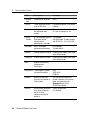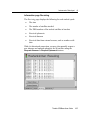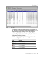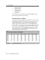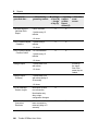
1
Trimble GPSBase
User Guide
F
Version 2.60
Revision A
Part Number 48595-00
September 2007
Corporate Office
Trimble Navigation Limited
Engineering and Construction Group
5475 Kellenburger Road
Dayton, Ohio 45424-1099
USA
800-538-7800 (Toll Free in USA)
+1-937-245-5600 Phone
+1-937-233-9004 Fax
www.trimble.com
Support Offices
[email protected]
Copyright and Trademarks
© 1999-2006, Trimble Navigation Limited. All rights
reserved.
Trimble, and the Globe & Triangle logo are trademarks
of Trimble Navigation Limited, registered in the United
States Patent and Trademark Office and other countries.
GPSNet, VRS, and Survey Controller are trademarks of
Trimble Navigation Limited.
Microsoft, Windows, and Outlook Express are either
registered trademarks or trademarks of Microsoft
Corporation in the United States and/or other countries.
All other trademarks are the property of their respective
owners.
Patents Pending.
Acknowledgements
Reference stations of the Bavarian Land Survey
Department in Munich, Germany were used during
development and quality assurance
(http://www.blva.bayern.de).
Release Notice
This is the September 07 release (Revision A) of the
Trimble GPSBase User Guide, part number 48595-00. It
applies to version 2.60 of the Trimble GPSBase
software.
Contents
1.
About this Manual .................................................................. xi
About Trimble GPSBase .....................................................................xi
Related Information........................................................................... xiii
Technical Assistance ......................................................................... xiii
Your Comments ................................................................................ xiii
1.
Installation and Licenses........................................................ 1
Introduction ......................................................................................... 2
System Requirements......................................................................... 2
Installation ........................................................................................... 2
Software Protection............................................................................. 3
GPSBase Basic Functionality ............................................................. 3
2.
GPSBase Environment ........................................................... 5
Introduction ......................................................................................... 6
Connecting the Reference Station to GPSBase.................................. 7
Connecting the Users to GPSBase..................................................... 7
3.
Getting Started ........................................................................ 9
Introduction ....................................................................................... 10
Start GPSBase .................................................................................. 10
1..1 Automatic startup of GPSBase ................................................ 10
1..2 The concept of modules .......................................................... 11
1..3 Starting and removing further applications .............................. 12
Trimble GPSBase User Guide
iii
Contents
The Main GPSBase Window............................................................. 13
1..1 The menu bar .......................................................................... 14
1..2 Status bar and time server ....................................................... 14
1..3 The navigator........................................................................... 18
1..4 The information pane ............................................................... 18
1..5 Graphs ..................................................................................... 20
The Output Window .......................................................................... 24
GPSBase Configurations .................................................................. 26
The GPSBase Tree Root .................................................................. 27
1..1 Available modules.................................................................... 28
Reporting .......................................................................................... 28
Mail Server Configuration.................................................................. 31
Setting up GPSBase Using the Main Configuration Wizard.............. 32
1..1 Receiver settings ..................................................................... 33
1..2 RINEX file storage settings...................................................... 36
1..3 DAT file storage settings .......................................................... 37
1..4 RTCM/CMR Generator (GPSBase) settings............................ 38
1..5 RTCM/CMR Generator (Receiver internal) settings ................ 42
4.
Orbit Information................................................................... 45
Introduction ....................................................................................... 46
Almanac Server ................................................................................ 46
1..1 Almanac – Status ..................................................................... 46
1..2 Almanac – Viewer .................................................................... 47
1..3 Almanac report ........................................................................ 48
Ephemeris Server ............................................................................. 48
1..1 Ephemeris properties............................................................... 49
1..2 Ephemeris – Status.................................................................. 51
1..3 Ephemeris – Viewer................................................................. 52
1..4 Ephemeris – URA .................................................................... 53
1..5 RINEX navigation files ............................................................. 54
iv
Trimble GPSBase User Guide
Contents
5.
Communication Control ....................................................... 55
Introduction ....................................................................................... 56
Connection Configuration for Input Data........................................... 56
1..1 Connection configuration for the reference stations:
The Receivers module............................................................. 57
1..2 The Receivers information pane .............................................. 59
Connection Configuration for Data Output ........................................ 62
Setting up a Connection: The Connection Wizard ............................ 62
1..1 Selecting the decoder .............................................................. 63
1..2 Selecting a connection name................................................... 64
1..3 Finishing the connection .......................................................... 67
Driver Selection................................................................................. 67
1..1 Configuring a serial COM port connection............................... 69
1..2 Configuring a modem connection ............................................ 70
1..3 Configuring a socket connection.............................................. 71
1..4 Configuring a multicast socket connection .............................. 74
1..5 Configuring an Ntrip client connection ..................................... 75
Satellite Selection ............................................................................. 84
1..1 Global satellite settings............................................................ 85
1..2 Local satellite settings at a specific receiver ............................ 86
1..3 Wide Area Augmentation System WAAS................................. 88
6.
Instruments: Data Input ........................................................ 91
Introduction ....................................................................................... 92
Receiver Modules ............................................................................. 92
1..1 Connecting a Receiver module................................................ 93
1..2 Restarting a Receiver module.................................................. 94
1..3 Removing a Receiver module.................................................. 94
1..4 Adding modules to a Receiver module .................................... 94
1..5 Receiver properties.................................................................. 95
1..6 Importing station data from IGS site logs................................. 98
1..7 Known coordinates of the reference station........................... 100
Trimble GPSBase User Guide
v
Contents
1..8 A scheduled reference station................................................ 101
1..9 Data logging........................................................................... 103
1..10 Remote data download .......................................................... 104
1..11 Satellite settings..................................................................... 106
1..12 Input of meteorological and tilt data ....................................... 106
1..13 Receiver voltage and temperature......................................... 110
1..14 Tracking settings.....................................................................111
1..15 Receiver control using a web browser................................... 113
1..16 Information pages for Receiver modules ............................... 114
1..17 Redundant communication link.............................................. 120
Weather Station Module.................................................................. 124
1..1 Weather Station properties .................................................... 126
1..2 Weather Station information pane.......................................... 127
7.
Data Storage ........................................................................ 129
Introduction ..................................................................................... 130
Storing Receiver Data to Hard Disk ................................................ 130
1..1 Reports on stored data .......................................................... 130
RINEX Storage................................................................................ 133
1..1 RINEX Storage settings ......................................................... 134
1..2 RINEX Storage information pages ......................................... 142
Compact RINEX.............................................................................. 144
DAT Storage.................................................................................... 146
Raw Data Storage ........................................................................... 147
Compressing Data Files.................................................................. 147
1..1 Compress settings ................................................................. 148
1..2 Compress information............................................................ 149
Storage Integrity.............................................................................. 150
1..1 Adding and removing a Storage Integrity module.................. 151
1..2 Storage Integrity settings ....................................................... 151
1..3 Storage Integrity information pane ......................................... 155
vi
Trimble GPSBase User Guide
Contents
1..4 Logging and reporting............................................................ 157
1..5 Interaction with the Storage modules..................................... 158
File Rollover Command................................................................... 160
8.
Data Output to Clients (Real-time) ..................................... 161
Introduction ..................................................................................... 162
RTCM Generators – General .......................................................... 162
1..1 The RTCM Generator module ............................................... 162
1..2 Reporting ............................................................................... 163
1..3 Gap detection in RTCM Generators ...................................... 163
1..4 Adding modules ..................................................................... 164
1..5 Removing the module............................................................ 164
Starting an RTCM Generator .......................................................... 164
1..1 Typical connections to clients ................................................ 165
RTCM Generator Properties ........................................................... 166
1..1 RTCM Generator properties – Data Format .......................... 168
1..2 RTCM Generator properties – RTCM 2.x Messages............. 171
1..3 RTCM Generator properties – RTCM 3.1 Messages............. 175
1..4 RTCM Generator properties – CMR Messages..................... 177
1..5 RTCM Generator properties – Caller Identification................ 178
Connection Settings ........................................................................ 179
The RTCM Single Station Generator Information View................... 181
1..1 RTCM Single Station – Status................................................ 181
Accounting ...................................................................................... 183
1..1 Activating accounting............................................................. 184
1..2 Accounting files...................................................................... 184
1..3 Accounting details.................................................................. 185
1..4 Data structure ........................................................................ 186
1..5 Using the accounting file........................................................ 187
Caller Identification Using SNMP .................................................... 187
1..1 The SNMP Configuration file ................................................. 188
1..2 The User List file.................................................................... 190
Trimble GPSBase User Guide
vii
Contents
RTController.................................................................................... 192
1..1 RTController settings ............................................................. 192
1..2 RTController information pane............................................... 196
9.
System Monitoring and Control......................................... 199
Introduction ..................................................................................... 200
Alarm System.................................................................................. 200
1..1 Setting alarms........................................................................ 201
1..2 Alarm information pages ........................................................ 213
Disk Watch ...................................................................................... 214
FTPMirror ........................................................................................ 217
1..1 FTPMirror information pane ................................................... 217
1..2 Logging the file transfer ......................................................... 219
1..3 FTPMirror settings ................................................................. 219
Watchdog ........................................................................................ 223
1..1 Monitoring computer activity .................................................. 223
1..2 QUANCOM Watchdog cards ................................................. 226
1..3 TimeOut 2400 ........................................................................ 226
1..4 Power Switch devices............................................................ 227
1..5 Watchdog properties.............................................................. 228
10. Other Modules ..................................................................... 229
Introduction ..................................................................................... 230
Splitter ............................................................................................. 230
1..1 Adding a Splitter module........................................................ 230
1..2 Getting information on the Splitter ......................................... 231
Single Point Position ....................................................................... 233
1..1 Single Point Position – Information page ............................... 233
1..2 Single Point Position averages .............................................. 234
Analysis Tools ................................................................................. 236
1..1 Raw Data Analysis ................................................................. 237
1..2 Point Position Analysis........................................................... 242
viii
Trimble GPSBase User Guide
Contents
APPENDICES
A.
Supported Receiver Types ................................................. 243
Introduction ..................................................................................... 244
Decoders and Instrument Types ..................................................... 244
B.
Testing Your Data Lines...................................................... 245
Introduction ..................................................................................... 246
Serial Communication ..................................................................... 246
1..1 Direct serial connection ......................................................... 246
1..2 Leased modem lines.............................................................. 247
Dial-In Connections via Modem ...................................................... 247
C.
Antenna Corrections........................................................... 249
Introduction ..................................................................................... 250
Antenna Phase Center Offsets ....................................................... 250
Antenna Files in GPSBase ............................................................. 251
1..1 Creating a customized antenna database ............................. 251
1..2 How to fill in the customized antenna.ini file .......................... 253
1..3 Structure of the Phase Correction Table ................................ 256
1..4 Use of ANTEX files ................................................................ 257
D.
RTCM Messages.................................................................. 259
Introduction ..................................................................................... 260
Standard RTCM v2.3 Messages ..................................................... 260
Standard RTCM v3 Messages ........................................................ 262
E.
NMEA Standard ................................................................... 267
Introduction ..................................................................................... 268
GGA – Global Positioning System Fix Data .................................... 269
Trimble GPSBase User Guide
ix
Contents
F.
Trimble File Formats ........................................................... 271
Introduction ..................................................................................... 272
Observation File .............................................................................. 272
Trimble Arc Inconsistency File ........................................................ 276
G.
Reports................................................................................. 277
Introduction ..................................................................................... 278
Log Files ......................................................................................... 281
Alarm Reports ................................................................................. 282
Almanac Reports............................................................................. 284
Raw Data Analysis Reports............................................................. 285
Point Position Analysis Reports ...................................................... 287
Data Storage Reports...................................................................... 289
1..1 The <data type> Report ......................................................... 290
1..2 The <data type> Summary report .......................................... 291
RTCM Generator Reports ............................................................... 293
Receivers Report ............................................................................ 295
1.
Abbreviations ...................................................................... 297
2.
Index..................................................................................... 301
14 E.
x
Trimble GPSBase User Guide
1. About this Manual
Welcome to the Trimble GPSBase User Guide. This manual describes
how to install, set up, and use the Trimble GPSBase software.
Even if you have used other Global Navigation Satellite Systems
(GNSS) products before, Trimble recommends that you spend some
time reading this manual to learn about the special features of this
product.
If you are not familiar with GNSS, visit Trimble’s website
(www.trimble.com) for an interactive look at Trimble and GNSS.
This publication assumes that you know how to use the Microsoft®
Windows® operating system.
About Trimble GPSBase
Trimble GPSBase is Trimble’s autonomous reference station
software. It is the ideal tool for most GNSS reference station
operations in application areas like land survey, construction,
mapping, GIS, and scientific applications. The software allows to:
•
Control the standard receiver settings;
•
Archive data for post-processing in Trimble DAT file, RINEX
and compact RINEX format;
•
Control the Trimble receiver’s generation of an RTCM/CMR
correction stream;
•
Generate an RTCM/CMR correction stream itself;
•
Analyze GPS and GLONASS data in various ways;
Trimble GPSBase User Guide
xi
About this Manual
•
Compute multipath effects from the receiver’s pseudorange
data;
•
Generate reports for all major functions on a daily basis;
•
Generate alarms and to notify the operator via email.
GPSBase is designed in a way to harmonize with Trimble reference
station receivers. For detailed information on the receiver and format
types we support, see Chapter 5.
GPSBase comes in several modules, including the following main
components:
The Ephemeris and Almanac server modules control and provide the
orbit information for all other system components; they also store this
information permanently to improve the start-up behavior of the
system. See Chapter 4, Orbit Information.
The Receivers module is the platform for the administration of the
Receiver module. See Chapter 5, Communication Control. The
Receiver module controls the GNSS (GPS and GLONASS) receiver
(see Chapter 6, Instruments – Data Input) and archives the data in
RINEX, Compact RINEX or Trimble DAT format (see Chapter 7,
Data Storage). All data is stored in a predefined folder tree structure,
which is ideal for distribution via Web or FTP. Multiple RINEX data
archives can be generated with different sampling intervals. RTCM
data for the reference station position may be transmitted, see Chapter
8, Data Output. The RTCM Manager administrates multiple RTCM
Generators: One module for each user.
System monitoring is supported by various modules. See Chapter 9,
System Monitoring and Control. The Single Point Position module
and various other Analysis modules analyze the data in every respect.
They put the results of the calculations at your disposal in graphical
and textual form. See Chapter 10, Other Modules.
The Appendices will ease the work with this manual as well as with
GPSBase by adding general information on supported receiver types,
RTCM messages, antenna height corrections and a list of
abbreviations.
xii
Trimble GPSBase User Guide
About this Manual
GPSBase is designed to operate under professional Windows
operating systems, such as Windows 2000 or later. Configuration
settings are easily defined using a built-in wizard (see Chapter 3,
Getting Started). For a detailed list of GPSBase system requirements,
see Chapter 1, Installation and Licenses.
Related Information
The GPSBase documentation is available in portable document
format (PDF) from the \Manuals\ folder on the installation CD. After
installation, you can also find it in the \Manual\ sub-folder of your
program folder.
Other sources of related information are:
•
Readme.txt file – a Readme.txt file contains information added
after the documentation was completed. To read this file,
double-click it or use a text editor to open it.
Technical Assistance
For Support & Upgrade contracts, contact your local distributor. All
queries regarding the GPSBase software and the installation can be
addressed directly via fax, phone, mail, and e-mail. For contact
details, refer to the front of this manual. Trimble undertakes to
respond within the shortest possible time within the limits of office
hours, public holidays and other occasions when the office is closed.
If you have a problem and cannot find the information you need in
the product documentation, contact your local dealer. or send an email to [email protected].
Your Comments
Your feedback about the supporting documentation helps us to
improve it with each revision. E-mail your comments to
[email protected].
Trimble GPSBase User Guide
xiii
About this Manual
xiv
Trimble GPSBase User Guide
CHAPTER
1
1.
Installation and Licenses
In this chapter:
Q
Introduction
2
Q
System Requirements
2
Q
Installation
2
Q
Software Protection
3
Q
GPSBase Basic Functionality
3
Trimble GPSBase User Guide
1
1
Installation and Licenses
Introduction
This chapter gives you an idea of the Trimble GPSBase system
environment and installation-dependent facts. It explains how
licensing works and describes the basic GPSBase functions.
The About dialog contains information on the GPSBase version and
build, the path to the GPSBase root folder, the type and version of
currently loaded software modules, and your current license status. To
open the About dialog, select the GPSBase main menu command
Help / About.
System Requirements
GPSBase is designed to run under Microsoft Windows 2000/XP/2003
Server.
Minimum hardware and software requirements for GPSBase are:
•
Microsoft® Windows® 2003 Server; Windows XP
Professional; Windows 2000, Service Pack 2 or later
•
Pentium PC with 500 MHz processor
•
256 MB RAM
•
10 GB hard disk (depending on amount of data to be archived)
•
Microsoft Internet Explorer, Version 6.0 or later.
GPSBase also can make use of multiple processor systems as well as
of dual-core processors.
Installation
An automatic installation of GPSBase is available from the
installation CD-ROM, if you put it into the CD-ROM drive. The setup
program will start automatically. Alternatively execute the file
setup.exe. From the splash screen select GPSBase. The installation
wizard guides you through the installation process.
2
Trimble GPSBase User Guide
Installation and Licenses
1
Software Protection
GPSBase is license-protected. With your installation CD for GPSBase
you have received a serial number and an authorization key that
enable GPSBase in combination with one Trimble receiver, such as
the Trimble 5700. When starting GPSBase the first time, a dialog
appears where you must enter both the authorization key and the
serial number. The status bar indicates BASIC for the licensing status.
To view your protection status, select Help / About / Protection from
the main menu.
GPSBase Basic Functionality
Table 1.1 illustrates the functions that are supported in the basic
GPSBase.
Table 1.1
Modules in basic GPSBase
Module
Function
GPSBase
The basic module. Includes a Time Server.
Receivers
Communication control. One connection (serial, socket
client or server) to a Trimble receiver.
Almanac
Server module for almanac data. Improves startup.
Ephemeris
Server module for ephemeris data. Improves startup.
Receiver
Controls a Trimble concise reference station receiver.
Weather Station
Controls a weather station instrument.
Raw Data Analysis
Analyses raw data. Detects and removes errors, such
as cycle slips.
Point Position
Analysis
Analyses the position accuracy of the connected
receiver at the current location.
RINEX Storage
Creates and stores RINEX files.
DAT Storage
Creates and stores Trimble DAT files.
Raw Storage
Creates and stores raw data files.
Trimble GPSBase User Guide
3
1
4
Installation and Licenses
Module
Function
Compress
Tool for file compression.
RTCM Single
Station
Generator
RTCM output of reference station. Serial connections.
RTController
Outputs real-time correction data directly from the
receiver.
Alarming
Administration of alarms.
FTP Mirror
Mirrors directories and files to FTP servers.
Disk Watch
Watches your disk and helps you keeping it clean.
Trimble GPSBase User Guide
CHAPTER
2
2.
GPSBase Environment
In this chapter:
Q
Introduction
6
Q
Connecting the Reference Station to GPSBase
7
Q
Connecting the Users to GPSBase
7
Trimble GPSBase User Guide
5
2
GPSBase Environment
Introduction
This chapter gives you some background information on the reference
station operating application Trimble GPSBase.
Figure 2.1 gives you an idea on possible hardware environment in a
GPSBase setup. The following sections then describe the
communication between the system components.
RS232
Trimble 5700
Trimble GPSBase
Local Reference Station
RS232
radio link
Figure 2.1
Radio Transmitter
Example hardware setup for the reference station system
GPSBase is completely modular. The reference station receiver is
connected to the control center using serial communication. For more
information see the section Connecting the Reference Station to
GPSBase.
The reference station’s data can be stored in multiple file formats
including RINEX, Compact RINEX (HATANAKA) and Trimble
6
Trimble GPSBase User Guide
GPSBase Environment
2
DAT files for post-mission services like postprocessing or additional
Internet services using a Web server.
GPSBase makes data available to users in various formats (RTCM,
CMR). See the section Connecting the Users to GPSBase.
Note – The GPSBase application is based on a modular concept
which can be configured to fit your needs and requirements. Several
features, such as the GPServer application and the GPSWeb web
server interface, are available as additional options for purchase.
Connecting the Reference Station to GPSBase
Connect your control center directly to the receiver using a serial
cable (RS 232 protocol). Run GPSBase and start the Configuration
Wizard to set connection parameters. Find a detailed description of
the Configuration Wizard in Chapter 3, Section Setting up GPSBase
Using the Main Configuration Wizard.
Different devices and protocols can be used to transfer the data from
the remote stations to GPSBase. Other communication links, such as
leased lines or frame relay using a TCP/IP interface avoid the
physical limitations of serial ports on the GPSBase server.
Connecting the Users to GPSBase
GPSBase supports two ways for the user to receive correction data:
•
A modem pool in the control center, connected to the serial
ports of the GPSBase computer. Each of these modems is
connected to a GPSBase RTCM Generator module, which uses
the Windows TAPI driver to control the modem.
•
Besides the two-way (bi-directional) communication to the
rover receiver, it is possible to configure an RTCM Generator
module to continuously send real-time data to cover a whole
area with reference station data, for example from a radio
transmitter tower.
Trimble GPSBase User Guide
7
2
GPSBase Environment
•
8
Rovers establish Internet connections to the control center
using, for example, GPRS. With multiple RTCM Generators,
GPSBase connects the rovers to the next available RTCM
Generator. The control center routes the data streams the
Trimble NTRIP Caster application to the rovers. For more
information on the Trimble NTRIP Caster refer to Trimble
NTRIP Caster Help.
Trimble GPSBase User Guide
CHAPTER
3
3.
Getting Started
In this chapter:
Q
Introduction
10
Q
Start GPSBase
10
Q
The Main GPSBase Window
13
Q
The Output Window
24
Q
GPSBase Configurations
26
Q
The GPSBase Tree Root
27
Q
Reporting
28
Q
Mail Server Configuration
31
Q
Setting up GPSBase Using the Main Configuration Wizard
32
Trimble GPSBase User Guide
9
3
Getting Started
Introduction
To get the Trimble GPSBase system started, you must at least connect
to the receiver. Typically, you will also add a RINEX storage module
to store data for post processing and add a RTCM Generator module
for real-time data distribution. A Configuration Wizard leads you
through these main tasks.
This chapter gives you an overview of all basic objects involved in
GPSBase and introduces into the main Configuration Wizard.
Start GPSBase
In the Start/Programs menu select GPSBase / GPSBase. It will
automatically start GPSBase loading the last used configuration. The
first time you start GPSBase, this will be the Default configuration.
Later, you may cancel the automatic loading: During startup, press the
keyboard button [ESC]. Select File / Load Configuration from the
main menu. For more information, see the section on configurations.
Automatic startup of GPSBase
For an automatic logon:
10
•
Start regedt32.exe from the command line to modify the
registry.
•
Bring the window HKEY_LOCAL_MACHINE on top.
•
In its navigator, go to Software/Microsoft/Windows NT/
CurrentVersion/Winlogon.
•
From the main menu, select Edit / Add value to add an entry
AutoAdminLogon, type REG_SZ, with value 1.
•
Select the entry DefaultUsername. Add an entry
DefaultPassword, type REG_SZ.
•
The user with DefaultUsername and DefaultPassword will be
logged on automatically with DefaultPassword.
Trimble GPSBase User Guide
Getting Started
C
3
•
From the main menu, select Security/Permissions. Change the
permissions of the Winlogon key to “Read” for ALL users
(Everyone) (only in the Winlogon folder). If you do not, you
will be logged on only once. The second time the machine will
ask for user and password again.
•
To test the automatic logon, reboot the computer. You should
be logged on automatically.
Warning – Make sure that the user with DefaultUsername has Write
access to the registry.
For an automatic start of GPSBase:
•
Put a shortcut to GPSBase in the Startup group of your
Start/Programs menu:
\GPSBase.exe
The concept of modules
GPSBase
Receiver
Raw Data Analysis
RINEX Storage
RTCM Generator
Disk Watch
Figure 3.1
Concept of modules
GPSBase is implemented in a modular application system. Different
applications can be combined within a common platform to provide
the functionality required. Again, the GPSBase application itself
Trimble GPSBase User Guide
11
3
Getting Started
consists of sub-modules with distinct functionality, as indicated in
Figure 3.1.
Starting and removing further applications
When GPSBase is started the first time, it will only show the root
item GPSBase. Here you start to add new modules (for example, the
Receivers module needed to build up the connections to the reference
station) as required by your reference station system. To add a module
to GPSBase or below another module, right-click this module, and
from the shortcut menu that appears select Insert Module. The
Module Selector dialog appears, listing the Trimble Application
Model (TAM) modules with additional functionality. Only the TAM
modules that can be started below the currently selected module are
displayed.
What happens after you have accepted a module depends on the
module selected. For detailed description see the module-related
chapters.
12
Trimble GPSBase User Guide
Getting Started
3
Removal of a module is easily performed from the module-related
commands. To remove a module from the application, select it and
open its shortcut menu with the right mouse button. There, you will
always find the menu entry Remove Module, which removes the
selected module and all its sub-modules.
C
Warning – Removing a central module (the Receiver module, for
example) will affect all dependent modules.
The Main GPSBase Window
The main GPSBase window consists of a menu bar, a status bar, a
navigator pane and an information pane. The information pane area
may offer one or several pages of information. The output window
may be docked to the GPSBase main window.
Trimble GPSBase User Guide
13
3
Getting Started
When you start GPSBase for the first time, the navigator will only
display the root item GPSBase. Afterwards, the navigator will display
at startup the last loaded configuration, with the focus on the root
item.
The menu bar
When GPSBase starts up, the menu includes a command called
GPSBase. Here you will find menu options that are specific to
GPSBase.
When you select (highlight) a module in the navigator, the menu bar
automatically adjusts itself to the module’s proprietary commands.
That means that all commands that are available using the module’s
shortcut menu equally are available from the menu bar.
B
Tip – For simplicity, only shortcut menu commands are given in this
manual. All commands are also available from the main menu.
Status bar and time server
The status bar displays the license status and acts as Time Server with
graphical indication of the used clock, display of the current date and
time, selection of the time system (local time, GPS time).
The Time Server tool automatically starts up with the startup of
GPSBase. It puts time information at the system’s disposal and sends
events through the system on new hour, new day etc. In the status bar,
it displays the current date and time in GPS time, as well as in UTC
or local time. The Time Server tool additionally allows you to
monitor the differences between the time derived from GPS satellites
and the computer time and to synchronize the computer time with
GPS time.
The Time Server tool searches for time information by the connected
receiver and all other instruments. If receiver time is not available, the
14
Trimble GPSBase User Guide
Getting Started
3
Time Server uses the current computer time. If you have exited
GPSBase or shut down the system, the Time Server restarts with the
last settings for the time system or automatic update.
icon indicates the reliability of the time using
A clock-shaped
traffic light colors:
•
Green: The time is received from the GNSS receiver.
•
Yellow: The time is received from the GNSS receiver, but no
information on the leap seconds or no current update by the
receiver.
•
Red: Time is received from the computer.
The time may be displayed as date and time [hh:mm:ss] in local time,
UTC time, or GPS time. Alternatively, also the current week and
seconds can be displayed in GPS time. To switch the time display
from one of these time systems to another, click the button next to the
time fields and then select the time system from the menu. The button
always displays the current time system:
GPS Seconds
GPS time in GPS week and seconds
GPS Time
GPS time in date and time
UTC Time
UTC time in date and time
Local Time
Local time in date and time
To monitor the differences between satellite time and computer time,
click the time system button again and select the Time Difference
Monitor command. This command (as well as the Update Once and
Update Automatically commands) is only available, if the system
receives time information from the GNSS receiver. The Time
Difference Monitor dialog appears displaying graphically the
differences between the current system time and satellite time as well
as continuously updating the current times of both systems and their
difference in numbers.
Since the system time usually is not as precise as the time received
from the atomic clocks used in the GPS satellites, you may want to
synchronize the computer time with the satellite time. Thus, file
Trimble GPSBase User Guide
15
3
Getting Started
creation or movement times, which are depending on system time,
will be synchronous to GPS time. You can synchronize the system
time either per command or you can define repeated
synchronizations.
To synchronize the system time with GPS time only once, click the
time system button, and then select the Update Once command from
the menu. The Update Once dialog appears. It displays the current
times from the computer (time from PC) as well as from satellite
information (time from GPS) and the difference between both times.
To synchronize the times, click the Update button.
16
Trimble GPSBase User Guide
Getting Started
3
Even after synchronization, the computer clock may gain or lose time.
To automatically synchronize it with the receiver time, click the time
system button, and then select from the menu the Update
Automatically command. The Automatic Update Settings dialog
appears.
By default, the automatic update of the computer time is switched off.
To start the automatic update, click the On radio button. To define
how often the computer time is updated, select from the time intervals
available from the Time interval for update drop-down list. Default:
1 hour. Automatic update is only performed, if the clock status is
green (time received from the GNSS receiver).
If the computer time and the satellite times differ for a high value, the
Time Server tool assumes that the computer time may be set by
purpose to a different time. It will not perform the synchronization,
but will indicate the large difference by changing the color of the icon
placed right from the time selection button to red:
Times are synchronous,
Times are asynchronous,
Automatic update is inactive (switched off).
In the Automatic Update Settings dialog, use the Time difference limit
drop-down list to define the limit for the maximum time difference to
be corrected for. If the time difference gets larger and the
Trimble GPSBase User Guide
17
3
Getting Started
synchronization error icon appears as red, you can use the Update
Once command to reset the computer time to GPS time at once.
The navigator
The navigator (module tree view) gives you a complete overview of
the active modules and of their hierarchical organization. A fully
configured system will form a tree-like structure, where each module
can be the base of a branch of other modules. Thus, it represents a
data flow view.
A good example of this functionality based grouping of modules is
the Receiver module: below this module, you can find an RTCM
Generator, a RINEX Storage module, and others, all of them working
with the data of this specific reference station only.
You can freely add and remove modules from the tree view while all
other modules are running. For example, it is no problem to add or
remove a RINEX Storage module without interrupting the normal
operation of the system.
In the navigator, each module is represented by the module name and
an icon. The icon may change its appearance depending on the
module status. See Table 3.1.
The information pane
On the right side of the main window is the detailed module view,
which lets you control the module that is currently selected in the
navigator pane. Depending on the module, the information pane may
offer one or multiple tab-pages of information, where the status of the
module is displayed and module configuration is possible. The tabs at
the bottom on the pane give you the access to the pages (see Figure
3.2). The contents of each page are described in the chapter on the
relevant module.
18
Trimble GPSBase User Guide
Getting Started
Table 3.1
Icon(s)
3
Modules and related icons
Module(s) represented by the icons
Main application GPSBase
Receivers module
Receiver module; Antenna settings OK
Receiver module; Antenna settings bad
Receiver module: switched to backup line
Receiver module: waiting for scheduled time
Almanac, Ephemeris server modules
Analysis modules, such as Raw Data Analysis
Data storage, such as RINEX Storage or DAT Storage
Alarm module
FTP Mirror module
Disk Watch
Watchdog module
Splitter module: indicating status of connection
RTCM Single Station Generator module, active and
inactive
Status of the module is BAD, according to the red
traffic light definition of the module (for more info, see
the respective detailed module view).
You may unlock some of the information pages to act as undocked
child windows. To make a tab a resizable child (floating) window,
in the upper right corner of
click the small window-shaped icon
the tab. Thus, you may view more than one information sheet
simultaneously and get multiple information on your system. You will
additionally be able to compare tabs displaying the same contents
with different parameters (such as the ephemeris of more than one
satellite, or the tracking status of more than one receiver).
Trimble GPSBase User Guide
19
3
Getting Started
Figure 3.2
Undocked information page “Receiver – Sky Plot”
Graphs
GPSBase comes with many modules that output results in form of
graphs. In particular, the analysis tools offer graphical display of their
results. To view a graph, click the respective tab of the information
pane of a module.
The information panes are described in detail at the respective
module. However, the graph pages all show the same general
behavior. They have a common set of graph options you can modify;
you can switch curves on and off as desired, you can zoom into them,
and you can print them.
20
Trimble GPSBase User Guide
Getting Started
3
Contents of a graph window
A graph consists of several regions: the most important being the plot
area where the data is displayed in form of curves. Inside the plot area
is the title text at the top, the axes with their labels and the axis
names, and the optional legend, which matches curve colors with
curve names.
The plot area is framed on the left side and the bottom by the two
axes. In the plot area, a grid can be switched on to simplify the graph
interpretation. The current data will be displayed in this plot area as a
polygon-line connecting the data points.
If more than one curve of data has to be displayed – fore example, if
you want to display the data of several satellites – a consistent set of
colors is used for each satellite. Thus you can identify a satellite by its
color.
The graph window is designed to be scalable: changing the size of the
window will enlarge or shrink the view of the graph. In addition, the
title, the axis names and the axis labels will follow. This way, you
have the greatest freedom of choosing your personal view of the data:
you can maximize one graph to fill the whole screen or you can
display dozens of tiny graphs in the main window, while still being
able to see useful information.
The graph’s axes adjust automatically when you resize the window.
Accordingly, the more space is available, the more “axis ticks” and
labels will be displayed on an axis. The labels are always adjusted to
display appropriate values, so for example no value like 1.66666666
will appear as a label.
Zooming
When you display a graph there are usually so many data points that
they cannot be easily distinguished from each other. To allow a closeup onto a specific graph section of interest, the graphs offer an easyto-use zooming facility.
Trimble GPSBase User Guide
21
3
Getting Started
Click inside the graph and drag a zoom rectangle that corresponds to
the region that you want to enlarge. When you release the mouse
button, the graph will be zoomed to that region. You can zoom
repeatedly until you have focused on your desired region.
To zoom back to the original size, right-click on the graph.
B
Tip – If you accidentally start zooming and you are still holding the
mouse button pressed, you can abort the zooming by simply moving the
mouse cursor completely outside the graph window. The zoom rectangle
disappears, and you can release the mouse button.
Time, curves, options
For many graphs, you may select a time range for the x-axis values
using the drop-down list in the upper right corner of the pane.
Depending on the graph, the following ranges may be available:
22
•
Last Minute
•
Last Hour
Trimble GPSBase User Guide
Getting Started
•
Last Day / 24 hours
•
Last 7 Days
3
The field below the drop-down list acts as a Curve Selector. Within
this field, you can specify which curves of the currently active graph
you want to see or hide. Just check the current check box or remove a
check.
Curve colors are permanently assigned to specific curves, often
satellites. Add the legend to the graph to see which color is assigned
to which curve. The legend is available using the Options button.
To select from the graph options, click Options on the lower right
corner of each graph. See Table 3.2 for the available options.
Table 3.2
Graph options
Option
Action
Y-Axis
This option allows you to select the scaling type of the
y-axis. With Auto Scale, it can be automatically scaled,
best fitting the current values and graph size (default).
Alternatively, with the Fixed Scale option you can
define the lower and higher boundary values, if you
edit the respective fields in the Fixed Y Scale dialog.
GPS-Time
The x-axis displays a time range. Here you can select
whether local time and date (default) or GPS-week
and –second is displayed.
Show Grid
If you select this option, a grid will help you to easily
read the values within the graphs.
Show Legend
Displays a legend within the graph at its right side.
Save Plot
Opens a Save As dialog and allows you to store a plot
of the current graph in a graphic format.
Print Plot
Opens a Printer dialog and allows you to print out a
plot of the current graph as you see it on the screen.
For example, if you do not want the legend to show on
the printout, switch it off before printing.
Trimble GPSBase User Guide
23
3
Getting Started
Print
To print out a graph as you see it on the screen, click Options, select
the Print Plot item, edit the printing properties, if necessary, and start.
C
Warning – When printing a graph, the graph will be automatically scaled
to fit to the size of the paper. This also means that in portrait mode the
graph will be stretched to be as high as the paper, which can result in
some distortion, since graphs are usually not displayed on screen in a
portrait orientation. To avoid this, switch the paper orientation to
Landscape in the Print dialog.
The Output Window
The output window helps to control GPSBase’s actions. When you
first start GPSBase, no output window is available. It appears, when
GPSBase starts outputting text of any kind. You may display or hide
the output window by checking or clearing the View / Output Window
menu option.
The output window acts as a control bar and consists of an exit
button, a message area and a vertical scroll bar. If it is not docked to
the main window, it also has a title bar showing Output Window as
caption. The process that generates messages runs in parallel to all
other tasks of GPSBase, so you can scroll through the text during
normal operation.
New messages are added to the output window even if they are not
visible (for example because you have scrolled to an earlier section of
the output, or the window is closed). All messages get a time stamp in
local time.
24
Trimble GPSBase User Guide
Getting Started
3
The output window holds up to 32,000 lines of messages. Once the
limit is reached, the older messages are discarded making space for
the newer ones.
The message type is color coded:
•
Black
information message
•
Green
warning message
•
Red
error message
A short-cut menu allows modifying the appearance of the window
and performing actions on the displayed messages.
Table 3.3
Output window options
Option
Action
Allow
Docking
A toggle option. If the command is 9 checked, the output
window will dock to a docking station of the client area. By
default, it is docked to the bottom of the screen. As soon as
you drag the top of the window near to a docking station,
such as the bottom of the client area or the toolbar area, the
output window will dock there. If you disable this option, the
output window becomes an independent, floating window,
resizable and moveable to anywhere on the PC’s screen.
Hide
Hides your output window. To re-open it select the menu
View / Output Window.
Filter
Filters the output window contents for display. You have
several selections, either for the type of message (errors,
warnings, status) or for the modules that create the
messages.
Store Output
A toggle option. If the command is 9 checked, the shortcut
menu indicates the folder where the current text file(s)
reside(s), into which output window messages are written.
Lets you select to store the text once or continuously. See
the following two rows.
Store Output:
Once
Opens a Standard File Selector and allows you to specify a
text file, to which all messages are saved. When you click
Save, GPSBase writes the contents of the output window
into the text file.
Trimble GPSBase User Guide
25
3
Getting Started
Option
Action
Store Output:
Start
Continuous
Continuously writes output messages into text files. When
selected, the Location dialog appears. Use this dialog to
specify the root folder for the path to the output files and to
specify the base for the filename creation. The file names
are automatically created from that base. Three numerical
digits and a character identify the day and hour of creation.
For detailed information on how the path structure to the
files is created see the section Settings of the Location
dialog in chapter 7, Data Storage.
Store Output:
Stop
Continuous
Stops continuous storage of output window contents.
Clear
Window
Deletes the contents of the output window. All messages are
discarded.
Font
Opens a standard Windows font selector dialog allowing
you to change the font and font attributes of the output
messages.
Float In Main
Window
If selected, the output window is a child window of the main
window. Then, the View menu lets you toggle the display of
the output window. Possible selections are: 1<configuration
name> and 2 Output Window. If 1<configuration name> is
selected, the navigator and information pane of the current
configuration are visible on top. 2 Output Window toggles to
the display of the output window.
GPSBase Configurations
When you start the Receiver module, the Almanac and the Ephemeris
server modules are also started automatically.
Once you have configured your GPSBase system with all required
components, save the configuration by using the main menu item File
/ Save Configuration. The Select Configuration Name dialog lets you
enter a new configuration name.
Also, when you terminate the application after changes were made,
you are asked if you want to save the current configuration.
26
Trimble GPSBase User Guide
Getting Started
B
3
Tip – Trimble recommends that you save your configuration. Thus, the
system will reload the last saved configuration automatically when
starting up, e.g., after power failure. Accordingly, you should configure
your computer using the Windows Startup program folder to
automatically log on and start the operating system and GPSBase after
reboot. See Section Automatic startup of GPSBase.
GPSBase supports the management of several configurations. Use the
File menu to:
•
save the current configuration (Save Configuration).
•
save a changed configuration under a different name (Save
Configuration As).
•
load a configuration without terminating GPSBase (Load
Configuration).
•
remove an unused configuration from the internal list: Select
Save Configuration As, activate the configuration name in the
list field and then click Remove Selected Configuration.
Even if you then cancel the dialog, the selected configuration is
deleted and is no longer available.
The GPSBase Tree Root
When you start GPSBase the first time, only the GPSBase root item is
available at the tree. Here you start to add new modules, (the
Receivers module, for example) as required by your reference station
system. The information pane displays the main Configuration
Wizard, see Section Setting up GPSBase Using the Main
Configuration Wizard. If at least one receiver is connected to
GPSBase, it additionally displays the Satellites Info page of the (first)
Receiver module.
Trimble GPSBase User Guide
27
3
Getting Started
Available modules
From the root item, you can add the following application modules:
•
Alarm
•
Almanac
•
Disk Watch
•
Ephemeris
•
FTPMirror
•
Receivers
•
Watchdog
These modules can be added either directly or using the Insert
Modules command. The commands are available from the short-cut
menu of the GPSBase navigator root item as well as from the main
pull-down menu command GPSBase. For more information on the
navigator, see Section The navigator.
Reporting
One of the major tasks of GPSBase is the generation of data output.
Data may be output as observational data files (raw data format,
RINEX, Compact RINEX, Trimble DAT observation file format, and
others, see Chapter 7, Data Storage), but also in the form of formatted
text, called reports. GPSBase generates text in the XML format. It
uses Windows Internet Explorer (IE) 6.0 (or any other browser that
can parse and display XML documents) to display reports.
To start the reporting, select the main menu command File /
Reporting. The Reporting dialog appears. It consists of the following
two tabs:
28
•
Report Selection
•
Report Path
Trimble GPSBase User Guide
Getting Started
3
The Reporting Selection dialog lets you enable reporting depending
on the generating module(s).
For the reports generated by the Storage modules and for RTCM
accounting information additional settings are available.
The Special Storage Reports dialog appears immediately, if you select
Storage Reports. You can view and change it any time, if you click
the Details button next to the Storage Reports checkbox. The dialog
lets you select several report types to be created additionally to the
standard XML reports. For more information see Chapter 7, Data
Storage.
With RTCM Accounting Information selected an additional SAPcompatible file will be written. This file contains information for each
rover dial-in session. The Accounting Details dialog appears
immediately, if you select RTCM Accounting Information. You can
Trimble GPSBase User Guide
29
3
Getting Started
view and change it any time, if you click the adjacent Details button.
For detailed information on accounting see Chapter 8, Section
Accounting.
Use the Report Path tab of the Reporting dialog to define the path for
the storage of reports. The Path for reports edit field becomes
available, if at least one type of reports is selected at the Report
Selection tab. The reports are stored to an enhanced folder structure.
If you click Write reports now many report generating modules
immediately write their current observations and results into the
respective report files.
Click OK to make reports available to GPSBase. Some files will be
copied to the location you have defined and the report generator will
be started at once. It automatically writes the reports of the currently
active modules in XML and text files. For a detailed description of all
available reports, see Appendix G.
30
Trimble GPSBase User Guide
Getting Started
3
Mail Server Configuration
Several of the modules offer an e-mail service option. For example, if
a situation occurs that induces an alarm (see the section on the Alarm
module in Chapter 9, System Monitoring), it can make sense to send
an automatically generated e-mail to the system administrator to have
him informed about the current state of the application. GPSBase uses
the SMTP protocol for e-mail transport.
With modules that generate e-mails, it is essential that the computer
running GPSBase is configured in a way that allows automatic e-mail
transport. To start the configuration select the main menu command
File / Configure Mail Server. It opens the SMTP Mail Transport
dialog with the Configuration tab. By default, e-mailing is disabled,
and the configuration does not apply.
Note – When adding modules to the system, which need to know the
SMTP server, the SMTP Mail Transport dialog appears automatically,
if e-mailing is disabled.
Select the Use SMTP Mail Server check box to enable the SMTP mail
server. Specify the address and IP port of the server computer. The
Trimble GPSBase User Guide
31
3
Getting Started
default port number is 25, the standard for listening ports at servers.
Specify whether the mail server does not require user authentication
(None, default selection) or else the authentication type, either Login
or Plain. With user authentication needed, provide the User name and
the Password.
Specify a valid e-mail account at the SMTP server, and a time period,
after which messages expire, if the connection to the server fails. You
may test the connection using the Send Test Mail button.
Setting up GPSBase Using the Main Configuration
Wizard
When you start GPSBase the first time, the information pane displays
a Configuration Wizard. The Configuration Wizard leads you through
the setup of GPSBase for one receiver and, if selected, for data
storage and distribution. Orbit information will then also be available
to the system. With all options selected you have a full GPSBase
reference station system.
The Configuration Wizard assumes that the Trimble receiver is
connected with a serial cable to the PC running GPSBase.
B
Tip – To use other connection modes, select the Insert Modules
command from the GPSBase tree root. From the Module Selector
dialog, select Receivers.
GPSBase supports various connections to receivers, such as modem
connections using TAPI, or TCP/IP connections in a LAN or WAN. For a
detailed description on how to connect to receivers, see Chapter 5,
Communication Control.
All you have to do for setup is to select from the modules for data
storage (do you want to store the receiver raw data in RINEX files or
in the Trimble DAT format?) and for real-time data distribution. For
RTCM/CMR data sent directly from the receiver select RTCM
Generator (receiver internal). To use the enhanced GPSBase
functionality for RTCM or CMR data distribution, select RTCM
Generator (GPSBase). Click Start Wizard. The following description
32
Trimble GPSBase User Guide
Getting Started
3
assumes that you have selected all options. If you did not, some
dialogs may not appear and the navigator tree will not show the same
structure.
Note – After a module is configured for the receiver, the respective
option is selected and grayed out in the Configuration Wizard. You
may re-configure it, if you first remove that module from the
navigator. Then the option is available again.
Receiver settings
The Receiver Communication Settings dialog appears. It lets you
define the com port, baud rate, number of data bits, number of stop
bits, parity type, handshake type, size of buffer and overlapping type.
Select the parameters from the respective drop-down lists.
These settings define a serial port connection. The connection name is
Trimble Receiver 1. The navigator now displays the Receivers module
and the Almanac and the Ephemeris modules for orbit information.
Trimble GPSBase User Guide
33
3
Getting Started
B
Tip – For detailed information on the Almanac and the Ephemeris server
modules, see Chapter 4, Orbit Information.
Click OK. GPSBase detects the receiver – this may take a couple of
seconds – and then opens the Receiver Data dialog.
34
Trimble GPSBase User Guide
Getting Started
3
The Receiver Data dialog lets you define the station information,
such as a numeric Station ID, marker name and number, and the
known reference position. Instead of entering known coordinates you
can select the Set position later through “Single Point” option. This
adds to the Receiver module a Single Point Position module and uses
its averaged positions as known coordinates for the reference station
receiver. You may keep or modify the default receiver settings for
elevation cutoff and tracking interval.
B
Tip – The settings for elevation cutoff and tracking interval directly
influence the receiver. For detailed information on Receiver modules,
see Chapter 6, Instruments: Data Input.
If you have selected the Set position later through “Single Point” option,
the Average Position dialog appears that lets you define minimum
thresholds for time and epochs. See Chapter 10, Section Single Point
Position.
Click Next. The Antenna dialog appears.
Trimble is pre-selected as the antenna manufacturer. The antenna type
selection in the Type field depends also on the selection in the
Trimble GPSBase User Guide
35
3
Getting Started
Antenna Model field. Currently, three antenna models are available.
Make sure you have selected the matching antenna model and the
height measurement method in the Antenna height measured to field.
Then edit the Height offset field. Click Finish.
B
Tip – For detailed information on how corrections for the antenna in use
are applied in GPSBase, see Appendix C, Antenna Corrections.
The Trimble Receiver 1 Receiver module is now added to the
Receivers navigator item. The information pane displays the Satellites
Info page.
B
Tip – After you have first defined the settings, they will always be
available for editing using the module’s shortcut menu command
Properties.
RINEX file storage settings
If you have selected RINEX File Storage, the RINEX Storage
Location dialog appears. It lets you view and define the target path
and folder for the file storage.
Select the file types to be stored from the Store Files group.
Select the destination using the Browse button next to the top field.
Select the type of folder structure for file storage. If you select one of
the Enhanced types, you do not have to trouble with data
organization. GPSBase will automatically add to the path selected the
sub-folders for the year (RefData.YY), month (Month.MMM) and, if
you have selected the Enhanced day option, the folders for the day
(Day.DD). Select the type of file naming and data structure. If you
select the Add point number to directory structure option, the
observation files are written into sub-folders named according to the
full point number of the station.
Click Finish. The RINEX Storage module is now added to the
Trimble Receiver 1 navigator item.
36
Trimble GPSBase User Guide
Getting Started
B
3
Tip – After you have first defined the settings, they will always be
available for editing using the module’s shortcut menu command
Properties. Detailed information on RINEX file storage can be found in
Chapter 7, Data Storage.
DAT file storage settings
If you have selected DAT File Storage, the DAT Storage Location
dialog appears.
This dialog lets you view and define the target path and folder for the
storage of files in the Trimble DAT format. It has the same
functionality as the RINEX Storage Location dialog, see above. Edit it
and click Finish. The DAT Storage module is now added to the
Trimble Receiver 1 navigator item.
Trimble GPSBase User Guide
37
3
Getting Started
B
Tip – After you have first defined the settings, they will always be
available for editing using the module’s shortcut menu command
Properties. For information on DAT file storage see Chapter 7, Data
Storage.
RTCM/CMR Generator (GPSBase) settings
Note – If you have also selected RTCM/CMR Generator (receiver
internal) the Real-time Message Transmission dialog appears first.
See the following section.
If you have selected RTCM/CMR Generator (GPSBase), a Raw Data
Analysis module is automatically added to the Receiver module
Trimble Receiver 1. The Raw Data Analysis module analyses the
38
Trimble GPSBase User Guide
Getting Started
3
consistency of dual-frequency data for each satellite. It detects
receiver errors and generates pseudo-range and range rate corrections.
If a cycle slip has been detected, the module tries to correct it. Data,
which can not be corrected, is removed from the data set, before it is
passed on to the RTCM/CMR Generator module.
B
Tip – Find more information on Analysis modules in Chapter 10, Other
Modules.
The Radio Communication Settings dialog appears. The settings on
this dialog define a serial port connection for data output. It is used in
the same way as the Receiver Communication Settings dialog, see
above Section Receiver settings. The default connection name is
Radio 1. Click OK.
The navigator now displays the RTCM Single Station Generator
module RTCM Radio 1 below the Raw Analysis Data module.
The Data Format dialog appears.
First, select the Output Type: RTCM Observations stands for output in
RTCM format, versions 2.1, 2.3 and 3.1. CMR stands for data output
in the Trimble CMR/CMR+ format. Accordingly, the selection in the
Output Format depends on your selection in the Output Type field.
Trimble GPSBase User Guide
39
3
Getting Started
See Table 3.4 for the relation between Output Type and Output
Format.
Table 3.4
Selections and Settings dialogs for the RTK survey style
Output Type
Output
Format
Settings Dialog Name
RTCM Observations
RTCM 2.1
RTCM 2.1 Messages
RTCM 2.3
RTCM 2.3 Messages
RTCM 3.1
RTCM 3.1 Messages
CMR
CMR Messages
CMR+
CMR+ Messages
CMR
Click Next. A settings page appears which lets you configure the
output messages. The name and options of the Settings dialog adjust
40
Trimble GPSBase User Guide
Getting Started
3
themselves to the chosen output format. See Table 3.4 for the possible
dialog names. For example, if you have chosen observations and
RTCM 2.3, the RTCM 2.3 Messages dialog appears.
Only those messages are possible that match the chosen output
format. Some of the messages may be obligatory for the chosen
format, and therefore, can not be disabled. You may select other
messages and define the output rates. With DGPS messages selected,
click DGPS Configuration to see and edit the settings for DGPS
messages. Click OK.
To finish the settings for the RTCM Single Station Generator click
Finish.
Note – According to the RTCM specifications, some of the RTCM
messages and some of the output rates depend on each other. You will
notice that you are not allowed to set combinations that do not work.
Trimble GPSBase User Guide
41
3
Getting Started
B
Tip – After you have first defined the settings, they will always be
available for editing using the module’s shortcut menu command
Properties. For detailed information on the RTCM Generators and their
settings see Chapter 8, Data Output (Real-time).
RTCM/CMR Generator (Receiver internal) settings
If you have selected RTCM/CMR Generator (Receiver Internal), the
Real-time Message Transmission dialog appears. Use it to configure
an RTController module that lets you broadcast the real-time
correction data in RTCM and/or CMR format.
Note – The Trimble receiver has to support the RTCM and/or CMR
broadcast option. If not, the Real-time Message Transmission dialog
and the respective settings will be grayed out, and the receiver cannot
be activated.
42
Trimble GPSBase User Guide
Getting Started
3
Select the output format, either RTCM Mode or CMR Mode. To edit
the respective settings for the selected mode, select the On option and
click Settings.
•
In RTCM mode, the RTCM Messages Settings dialog appears.
Select the secondary messages and output rates, and enter the
station ID and text for message #16, if selected. Accept your
settings.
•
In CMR mode, the RTCM Messages Settings dialog appears
that lets you define station ID and time delay. Accept your
settings.
To configure the receiver port, click Port Settings. For more
information on the parameters, refer to your receiver manual. Accept
your settings.
Click Finish. The navigator now displays the RTController module
below the Receiver module Trimble Receiver 1.
B
Tip – After you have first defined the settings, they will always be
available for editing using the module’s shortcut menu command
Properties. For detailed information on the RTController and its settings
see Chapter 8, Section RTController.
Trimble GPSBase User Guide
43
3
44
Getting Started
Trimble GPSBase User Guide
CHAPTER
4
4.
Orbit Information
In this chapter:
Q
Introduction
46
Q
Almanac Server
46
Q
Ephemeris Server 48
Trimble GPSBase User Guide
45
4
Orbit Information
Introduction
The Ephemeris and Almanac server modules collect the orbit
information and provide it to all other modules in GPSBase. The
information is stored to improve the startup behavior of the system.
Almanac Server
The Almanac server stores the GNSS almanac data. In combination
with the antenna phase correction table the almanac is used to
calculate elevation dependent antenna phase offsets. It writes the last
valid almanac value into the registry and deletes the former one.
Thus, the best available almanac is immediately at GPSBase’s
disposal, also if a system restart should be necessary.
The Almanac server is started automatically when you insert the
Receiver module into GPSBase. You may, however, also start an
Almanac server manually, if you highlight the navigator item
GPSBase and select its shortcut menu item Almanac.
When you first click the navigator item Almanac, GPSBase will
automatically load the current almanac file. For the module, two
pages of information exist.
B
Tip – As it is the case throughout GPSBase, the icon
in the upper
right corner of the information pane lets you undock the currently
activated information page. The floating window will then stay
permanently in front of the main window.
Almanac – Status
The list on page Status displays:
•
Sat: Satellite and health status in form of a traffic light
Green: healthy
Yellow: almanac too old or not available
Red: unhealthy
46
Trimble GPSBase User Guide
Orbit Information
•
Health: health indicator, where 0 stands for healthy, all other
numerals for unhealthy
•
Week: GPS week
•
Seconds: GPS seconds
•
Time: Date and time.
4
The Delete Almanac button allows you to delete the current almanac.
If you want the current almanac to be stored, select the Store almanac
file check box.
A file called almanac.YYa will be stored into the GPSBase
installation folder. YY stands for the creation year.
Almanac – Viewer
The Viewer page of the Almanac server displays detailed almanac
information for each satellite. Select the GNSS satellite for which the
almanac should be displayed on top of the pane using the Almanac
data for satellite drop-down list.
Trimble GPSBase User Guide
47
4
Orbit Information
Besides standard parameter information, a full explanation of this
parameter is displayed.
Almanac report
With Reporting activated, you may view a report generated from
Almanac.xml using Windows Internet Explorer or any other browser
that can parse and display XML documents. For more information on
the reports, see Appendix G, Reports.
Ephemeris Server
The Ephemeris server manages the GNSS satellite ephemeris for
GPSBase. It writes the last valid ephemeris values into the registry
and deletes the former ones. Thus, the best available ephemeris is
immediately at GPSBase’s disposal, also if a system restart should be
necessary.
48
Trimble GPSBase User Guide
Orbit Information
4
An Ephemeris server is started automatically with default properties,
when you insert the receiver module into GPSBase. You may also
start an Ephemeris server manually, if you highlight the navigator
item GPSBase and select its shortcut menu command Ephemeris.
For the Ephemeris module, there are three pages of information.
B
Tip – As it is the case throughout GPSBase, the icon
in the upper
right corner of the information pane lets you undock the currently
activated information page. The floating window will then stay
permanently in front of the main window.
Ephemeris properties
When an Ephemeris server module is first started, it works with the
default settings. You may change the settings at any time: In the
navigator, set the focus on the module and select the shortcut menu
command Properties. The Ephemeris Server Properties dialog
appears with the Ephemeris Options and Dis Files pages.
Ephemeris options
To avoid inconsistencies between the reference station and rover and
to make sure the rover can use the same ephemeris as the reference,
the usage of the ephemeris at the reference station receiver is delayed.
Use the Time Delay group of the Ephemeris Options property page to
set a value for this delay. The default delay value is 90 seconds.
GPSBase does not use predicted orbits.
Arc inconsistencies
When GPSBase receives new ephemeris, it can calculate the position
of the satellites in the constellation in two ways: using either the old
ephemeris data or the new one. The differences between the results
are the arc inconsistencies. These can be stored in a data folder.
Trimble GPSBase User Guide
49
4
Orbit Information
Arc inconsistencies are only calculated, if the ephemeris data age is
less than a given value. The Arc Inconsistency Calculation group lets
you set the maximum age difference between the old and the new
reference time of ephemeris. You can set values, in GPS seconds, for
GPS satellites and GLONASS satellites. Default values: 21600 GPS
seconds for GPS, 3600 GPS seconds for GLONASS.
To return to the default settings of the Ephemeris Options tab, click
the Back to Default button.
DIS file storage
To store arc inconsistencies as files with the extension .dis select the
Store arc inconsistencies to file option and set the path for the data
folder using the browse button. From the Browse For Folder dialog
50
Trimble GPSBase User Guide
Orbit Information
4
you can select from existing folders or create a new one: Click Make
New Folder. For a description of the file format see Appendix F,
Trimble File Formats.
Ephemeris – Status
The list on the Ephemeris server’s information page Status displays:
•
Sat: Satellite and health status in form of a traffic light
Green: healthy
Yellow: broadcast ephemeris too old or not available
Red: unhealthy
•
Health: health indicator, where 0 stands for healthy, all other
numerals for unhealthy.
•
Iode: Issue of data (ephemeris)
•
Week: GPS week
•
Seconds: GPS seconds
•
Time: Date and time
Trimble GPSBase User Guide
51
4
Orbit Information
The Delete Ephemeris button allows you to internally delete all
ephemeris information. If you want all ephemeris to be stored in a
file, click the Save File button to define the path to the target folder.
The RINEX ephemeris file is written immediately.
Ephemeris – Viewer
The Viewer page of the Ephemeris server information pane shows the
full ephemeris information for a selected satellite. To display
ephemeris information for a satellite, select the satellite name from
the list at the top of the pane.
The list shows the standard parameter name, value, unit, and a full
explanation of the parameter.
52
Trimble GPSBase User Guide
Orbit Information
4
Ephemeris – URA
The info page URA displays User Range Accuracy values for GPS
satellites. You will find a button for each GPS satellite, displaying its
PRN number (1 to 32) and its status in form of traffic light colors.
•
Green: User Range Accuracy is less than or equal to 5,7 meters
•
Yellow: User Range Accuracy is between 5,7 and 16 meters
•
Red: User Range Accuracy is higher than 16 meters
•
White: No information available for this satellite.
On the right side, you will find information corresponding to the
currently selected satellites.
The information includes user range accuracy internal coding (URA
internal information), user range accuracy converted to meters (URA
in meters) and the time reference for these user range accuracy values
(Time).
Trimble GPSBase User Guide
53
4
Orbit Information
The URA value in meter is calculated from the SVacc value of the
ephemeris (see page Viewer). Table 4.1 gives the relation between
SVacc and URA in meters.
Table 4.1
SVacc
Relation between SVacc values and URA
URA in meters
SVacc
URA in meters
0
2.0
8
64.0
1
2.8
9
128.0
2
4.0
10
256.0
3
5.7
11
512.0
4
8.0
12
1024.0
5
11.3
13
2048.0
6
16.0
14
4096.0
7
32.0
15
8192.0
RINEX navigation files
When RINEX Storage is active (see Chapter 7, Data Storage), the
ephemeris server writes hourly ephemeris data into the folder
specified by the RINEX Storage module, where the station identifier
is replaced by the characters “Ephm”, such characterizing the
ephemeris file valid for all stations.
54
Trimble GPSBase User Guide
CHAPTER
5
5.
Communication Control
In this chapter:
Q
Introduction
56
Q
Connection Configuration for Input Data
56
Q
Connection Configuration for Data Output
62
Q
Setting up a Connection: The Connection Wizard
62
Q
Driver Selection
67
Q
Satellite Selection
84
Trimble GPSBase User Guide
55
5
Communication Control
Introduction
Communication control is one of the main tasks of GPSBase during
system setup and maintenance. Communication control is equally
essential for data input and output. A Connection Wizard guides you
through all steps necessary to establish connections for data transfer
in any direction.
The Receivers module is used to configure your connection to the
reference station receiver and to a weather station for data input.
Different connection methods are available that allow you to transfer,
for example, the reference station data from the remote station to the
control center.
Similarly, GPSBase controls the connections for position and
correction data output to rovers using the connections to its RTCM
Single Station Generators.
This chapter details the use of the Receivers module as well as how to
select the matching driver DLL and to set up connections using the
Connection Wizard.
B
Tip – Before adding a Receiver module to the module-tree of
GPSBase, make sure that the data transmission between receiver and
the control center computer is working without problems. To
successfully operate a reference station system, it is crucial that all
hardware and software used for data transfer is working correctly. For
information on testing the data transmission, see Appendix B, Testing
Your Data Lines.
Connection Configuration for Input Data
The main tool for configuring your reference station system within
GPSBase is the Receivers module. Read this chapter for detailed
information on this module. Configuring connections to instruments
(receiver, weather stations) is described in Section Setting up a
Connection: The Connection Wizard.
56
Trimble GPSBase User Guide
Communication Control
5
Note – GPSBase uses the Receivers module to configure the system.
The reference station receiver that is connected to GPSBase is
represented by the Receiver module, a specific type of an Instrument
module.
Connection configuration for the reference stations: The
Receivers module
The Receivers module lets you configure the connection to your
reference station system within GPSBase. The module itself is a
branch of the main module GPSBase. To add the Receivers module to
GPSBase, right-click GPSBase in the navigator, then select the
shortcut-menu command Receivers. The module will immediately
show up in the navigator. Click the navigator item Receivers to
activate it.
There are two ways to start an instrument module:
•
•
Right-click the navigator item Receivers to open its shortcutmenu and select the item Connect.
From the information pane Receivers – Port Info click the Add
connection button.
Both actions start the Connection Wizard with the Decoder page (see
Section Setting up a Connection: The Connection Wizard). After you
have finished the connection setup and started the instrument, the
navigator will show the entry <Receiver name> or Weather Station as
a branch of Receivers. An Almanac server and an Ephemeris server
are automatically started when the reference station receiver is
connected.
If a reference station connection is not used any more in the system,
you may remove the connection to the reference station using the
shortcut menu command Remove Module of the instrument.
If GPSBase does not find the receiver specified in the connection
profile after a specified time limit (length depends on the receiver
type), the decoder will be loaded in a passive mode. GPSBase now
waits for incoming data.
Trimble GPSBase User Guide
57
5
Communication Control
B
Tip – If the receiver is recognized correctly and its properties are
configured, the Receiver information pane will show detailed
information on the reference station. Detailed information on the
Receiver module is given in Chapter 6, Section Receiver Modules.
Other functions of the Receivers module
For use in postprocessing software or for later re-import to the
system, you have two options to export the reference station
information of all connected stations in the system.
58
•
You can export the station position to a position file in the
ASCII text format. You can update automatically the position
in the system using the File / Update Positions command from
the main menu (see Chapter 6, Section Settings on the Receiver
Data page). To write the position to a text file, select the
shortcut menu command Save Positions of the Receivers
module. It opens a Windows file storage dialog that lets you
edit the file name and path to it.
•
You can export general reference station information to a file
in the IGS site log format. To do so, select the IGS Site Logs /
Export shortcut menu command from the Receivers module. It
opens the Browse For Folder dialog that lets you select the
folder for the automatically created log files. For how to import
positions from an IGS Site Log file, see Chapter 6, Section
Settings on the Receiver Data page. Export information
includes the following:
•
Marker Name: to correspond the 4 character ID used by
the IGS site logs, it is essential that the marker name does
not contain more than 4 characters, otherwise the export
will fail.
•
Marker Number corresponding with the IGS Site name.
•
Positions in Cartesian X,Y,Z coordinates.
Trimble GPSBase User Guide
Communication Control
5
•
Receiver information, such as type, observed satellite
system, serial number, firmware version, and elevation
cutoff setting.
•
Antenna information, such as type, serial number, height
offset. GPSBase works with horizontal position offsets
and alignments of 0.000m.
•
RINEX header information, such as agency and observer
(the latter corresponding to the site log entry Preferred
Abbreviation), and an unlimited number of 40-character
comment lines.
If reporting is activated, the Receivers module creates the Overview
of Connected Receivers report. You can view the report by opening
the file Receivers []status $<sessionID>.xml in your Web browser.
For more information on the reports, see the Appendix G, Reports.
The Receivers information pane
The Receivers information pane displays six pages of information:
•
Port Info
•
Position Info
•
Antenna Info
•
Tracking Info
•
Scheduler Info
•
Voltage and Temperature Info
After you have set up the receiver and added the connection to it to
GPSBase, the Receivers information pane displays all available
information in numerous tabs. The name and tracking status of the
connection profile is always given in the first column Connection.
You can double-click the connection name, and the focus will
automatically jump to the selected Receiver module (for more details
on the receiver information see Chapter 6, Information pages for
Receiver modules).
Trimble GPSBase User Guide
59
5
Communication Control
An intelligent sorting algorithm lets you sort the stations according to
several properties by clicking the headers of columns. For example, to
sort the stations according to their Station ID, click the Port Info tab
and click the header of the Station ID column.
The Receiver column on the Port Info page gives the receiver or
weather station identification. The Station ID and the Marker Name
are also derived from the receiver settings. The connection parameters
are summarized in the Configuration column.
If you have defined a connection profile, but the connection is not
available due to, for example, a failure of the transmitting media, the
receiver will be identified as Not available.
The Add connection button activates the Connection Wizard. See
Section Setting up a Connection: The Connection Wizard.
With bi-directional connections, the Receiver Info page gives more
information on the receivers connected: For each connection, the
type, serial number, and firmware version of the receiver used at the
station with the given Station ID are listed. In passive mode, the
entries for Serial Number and Firmware Version are UNKNOWN.
The Position Info page displays the known Lat, Long, h, and X,Y, Z
coordinates of the station. Antenna information, such as the antenna
type, the height measurement type and antenna offsets, is summarized
for each station in the Antenna Info page. The respective tracking rate,
60
Trimble GPSBase User Guide
Communication Control
5
the elevation cutoff and the PRN numbers of tracked satellites can be
found on the Tracking Info page.
The Scheduler Info page lets you view the scheduler settings of the
receiver. Thus, you can easily provide consistent settings for both
types of schedulers, the data logging and/or the receiver connection
scheduler. For more information on the schedulers, see the respective
sections in Chapter 6, Instruments.
The first three columns of the table refer to the settings for data
logging scheduler as input in the Receiver Data Logging Scheduler
dialog. The Receiver Internal Data Storage column displays for each
connection, whether data logging is active or not. If it is, you see the
scheduled days of the week there. The daily start time and the
duration in hours of scheduled data storage follow. The next three
columns refer in the same way to the receiver connection scheduler.
View the voltage and temperature status of an actively connected
Trimble reference station receiver at the Voltage and Temperature Info
page. The first three columns of the table refer to the current voltage
source. They show for each connection the current voltage (Voltage),
the voltage source (Source, either number of the external port or of
Trimble GPSBase User Guide
61
5
Communication Control
the internal battery slot), and the relative value of the current voltage
in percent of the maximum available voltage from that source
(Status). The External power / Internal power columns refer to the
current status of all possible power sources in absolute volt values.
For the current internal receiver temperature, see the Temperature
column. With receivers that are passively connected or cannot
transmit their physical status, the status is Not available.
Connection Configuration for Data Output
GPSBase has many tools to output data to rovers or other addresses.
Such tools are the RTCM Single Station Generator modules, but also
the Splitter modules. These modules are added to the tree at different
locations, depending on the data they are propagating.
For detailed information on data output, see Chapter 8, Data Output.
Setting up a Connection: The Connection Wizard
The Connection Wizard always appears, when you begin configuring
a connection. The pages it displays depend on the purpose of the
connections. The following information is needed to identify a
connection:
•
62
The decoder type for the receiver data (only for incoming data,
for example from a reference station or weather station).
Trimble GPSBase User Guide
Communication Control
•
The interface driver type and settings for connection to the
station.
•
The unique connection name.
5
The Connection Wizard stores this (and more detailed) information in
connection profiles. It allows you to define and remove connection
profiles and to establish a connection using the selected connection
profile.
Selecting the decoder
When a decoder for input data is needed, the connection profile has to
provide decoder type information. The following modules need
decoder type information:
•
Receiver modules, i.e. reference station modules
•
Weather station modules
In these cases, select Receivers, then use either the shortcut menu
command Connect or the Add Connection button in the Receivers
information pane.
This will start a search for all available decoders in your installation
of GPSBase. A decoder is a Dynamic Link Library (DLL) module,
which is designed for communicating with one specific type of
receiver. New receiver types can easily be added to your installation
by purchasing the corresponding decoders and adding them to the
installation folder.
Currently, the GPSBase installation offers the following decoders:
•
Trimble (concise)
•
Trimble remote download
•
Weather Station (NMEA output format)
•
Weather Station Vaisala HMP243
fits into 9600 baud
used for postprocessing
Trimble GPSBase User Guide
63
5
Communication Control
For a list of all supported receiver types and their corresponding
decoders see Appendix A, Supported Receiver Types.
Select a decoder type matching your receiver type and click Next.
The next dialog of the Connection Wizard allows you to define a new
connection or to select a pre-defined connection.
Selecting a connection name
A set of connection parameters is called a “Connection” or a
“Connection Profile”. A connection profile may differ from another
connection profile only by a single parameter. (For example, you may
set the data transfer rate to different values for a reference station, or
select a different COM port).
GPSBase manages its connection profiles in separate lists, depending
on the application.
64
Trimble GPSBase User Guide
Communication Control
5
Use this dialog to add, to configure and to remove connection
profiles, and to select one for establishing a connection.
Adding a connection
The first time you use the Connection Wizard for a specific list of
profiles, no connection profiles are available. To add a connection
profile, click the Add button in the connection profile dialog. The
Enter Connection Name dialog appears. Enter a unique connection
name. Typically, you will enter either a station name or a reference to
baud rate, or Com port (e.g., Munich_COM7_9600Bd). This name
will be used to represent the connection in the system.
After you have accepted the new name with OK, the Driver Selector
allows you to select from the current list of interface drivers for
connection to the instrument. For information on how to proceed see
the section Driver Selection. Depending on the selected driver, you
will then define the respective parameters.
Trimble GPSBase User Guide
65
5
Communication Control
Table 5.1
Examples for Connection Wizard’s first lines
For a list of …
Used by this module
…
The first line of the
respective Connection
Wizard page reads…
Input connections
Receiver,
Weather Station
Select a connection name,
Output connections
for raw data
Splitter (output)
Select connection
Output connections
for correction data
RTCM Generator
Select RTCM output
medium
Connections to
device monitoring
computer activity
Watchdog
Select connection name
Selecting a connection: Activating the connection
To select a pre-defined connection profile, highlight its name in the
connection profile dialog of the Connection Wizard and click Finish.
GPSBase loads the connection profile and uses it to search for the
instrument and connect to it. Its name and configuration parameters
will show up in the respective information pane. The navigator will
display the instrument as a branch of the parent module.
Configuring a connection
To edit a connection profile, click Config. Depending on the choice
of the Driver DLL, different setting dialogs pop up, for example, the
Communication Settings dialog for the Serial Port Handler, or the
Socket Client Configuration dialog of the Socket Client handler DLL.
Note that the configuration will change immediately after you have
closed a settings dialog with OK.
66
Trimble GPSBase User Guide
Communication Control
5
Removing a connection profile
If you do not need a specific connection any more, you may remove
the profile from the list of connections. Highlight the respective
connection name in the list, then click Remove.
Finishing the connection
After you have chosen the connection name from the connection
selection dialog, and have accepted the settings, finish the creation of
the connection by clicking Finish. When the connection is detected
for the first time, the Properties dialog for the module will pop up and
allow you set all module-dependent parameters. Instructions on how
to set the parameters are described in the referring chapters for the
module.
Driver Selection
The Driver Selector dialog lets you select from the current list of
interface drivers for connections to instruments. It appears when you
are adding a connection.
Handlers or drivers are Dynamic Link Library (DLL) files, which
provide the communication interfaces for GPSBase.
Trimble GPSBase User Guide
67
5
Communication Control
There are currently six of these communication interface-DLLs
available in GPSBase:
•
Ntrip Client: connecting an instrument or a Connection Router
to an NtripCaster using a Source-table list for selecting the data
source.
•
Serial Port Handler: connecting a data source (receiver,
network router modem) using a serial cable directly to the
GPSBase computer.
•
Socket Client: for connecting the GPSBase program with the
data source (receiver, network router) within a WAN/LAN
using a TCP/IP interface. In this case, the data source will act
as Socket Server.
•
Socket Server: for connecting the GPSBase program with the
data source (receiver, network router) within a WAN/LAN
using a TCP/IP interface. In this case, the data source will act
as Socket Client.
•
TAPI 1.4 -2.2 Data Modem: For a connection to the data source
(network router modem) via telephone line using any type of
modem supported by Windows TAPI interface. GPSBase’s
handler is compatible to the TAPI standard Versions 1.4 up to
2.2.
•
Multicast Socket Server: Multiple connections on one TCP/IP
address on the same port. Only available when GPSBase is
configured for the output of data (for example, for
communication between GPSBase and the rovers using the
RTCM Generator, or for a Splitter).
The list of drivers gives you an overview of all version-compatible
communication interfaces that GPSBase has detected and can use for
the current application. The selection displayed depends on your
current application.
The socket driver DLLs come in pairs: there is a Socket Server and a
corresponding Client. Due to the communication concept of sockets,
68
Trimble GPSBase User Guide
Communication Control
5
one of two connected applications must be a server, while the other
one is a client.
At the bottom of the Select Driver dialog, the group Dynamic Link
Library of Driver gives you more information about the driver DLL
that is currently selected. Its identifying Name is displayed as well as
its file name including the complete folder Path.
Select the driver and click OK. Depending on the choice of the
handler, different settings dialogs will pop up, for example, the
Communication Settings dialog for the Serial Port Handler, or the
Socket Client Configuration dialog of the Socket Client handler DLL.
Note – The configuration will change immediately after you have
closed a settings dialog with OK.
Configuring a serial COM port connection
For the Serial Port Handler the Communication Settings dialog lets
you define the com port, baud rate, number of data bits, number of
stop bits, parity type, handshake type, size of buffer and overlapping
type. Select the parameters from the respective drop-down lists and
click on OK.
Trimble GPSBase User Guide
69
5
Communication Control
Configuring a modem connection
The modem connection is typically used for directly connecting rover
receivers to the control station.
Follow these steps to set up a modem interface in GPSBase:
1.
Install the modem driver on your computer and test whether the
connection to your modem is working correctly.
2.
Set the modem communication parameters and make test calls
using your modem.
3.
If you are using a leased line for connecting GPSBase with the
receiver, test the correct operation of the line.
4.
Use the Modem Configuration dialog to make the modem
known to GPSBase (this section).
5.
Test the connection to the reference station receiver by trying a
manual dial-in using terminal software.
When you configure this handler DLL (select the TAPI 1.4-2.2 Data
Modem list item, then click OK), the Data Modem Configuration
70
Trimble GPSBase User Guide
Communication Control
5
dialog pops up. It lets you set the dialing properties for the modem
(for example, if your phone system requires you to dial a leading zero
before the actual number) and to select and configure the modem
driver and COM port. For data output, the number to dial can also be
entered here.
Click OK to close the Data Modem Configuration dialog. The
program starts the TAPI Data modem. You can see the initialization
messages in the Output Window.
There are two further options:
Required password for login
Do not activate the Login requires password option, since rover
receivers do not support user name and password authentication.
Time delay after connection closed
After a modem connection has been closed, GPSBase re-initializes
the modem to prepare it for the next incoming call. This reinitialization can be delayed by entering a value in the Seconds delay
till online after connection closed list field.
Setting this field to, for example, 30 sec will release the modem after
a connection has been terminated. The modem is free for access by
other programs within this period. After 30 sec, GPSBase will try to
initialize the modem again and start waiting for incoming calls.
Set this option to a value other than zero, if you are using different
applications concurrently on one modem or if the modem needs a
longer time to recover from a call hang-up.
Configuring a socket connection
A possible setup of the system may be, for example, the data transfer
from the receivers using Terminal Servers to a network router. The
network router then manages the incoming data. If the reference
receiver and the GPSBase computer are running within a computer
Trimble GPSBase User Guide
71
5
Communication Control
network (Internet or a Wide Area Network similar to the Internet),
you can use this network for the communication between GPSBase
and the receiver.
The mechanism employed for communication on a Wide Area
Network (for example, Frame Relay) is called “Socket”. It is also
known as "TCP/IP-Protocol" and one of its major applications is the
Internet. It is a standardized way of connecting two applications on
different computers and to exchange information and data between
them. Therefore, it is required that each computer has a unique
address ("IP-address") within the network of computers it is running.
This network can, for example, be a Local Area Network (LAN, for
example within a company) or the Internet.
Once a communication partner is located using its IP-address, there's
also the need to correctly identify the application program on that
computer, to which one wants to "talk" to. Within the TCP/IP
communication standard this addressing is done using "IP-port
numbers" which are also known as "sockets". The port number again
has to be unique within its environment, meaning each application
which uses Socket communication on the computer must use different
port numbers.
Moreover, the Socket communication is realized as a "client-server"
concept. One of the two communicating applications must be
configured to take on the role of the "server", who is continuously
waiting for others to connect to its socket. The other application is the
"client" (possibly one of multiple clients) who connects to the server's
socket and disconnects again, when data exchange is finished.
To configure a GPSBase receiver module as the Server for a Socket
connection, use the Socket Server handler DLL (from the Driver
Selector dialog, select the Socket Server list item, and then click OK).
It will allow the use of TCP/IP protocol standards for the
communication between the computers.
The Socket Server Configuration dialog pops up. It lets you define the
IP port number, which will be used for the communication via the
TCP/IP protocol. You may select any number, which is not occupied
by another service or protected by a firewall system.
72
Trimble GPSBase User Guide
Communication Control
B
5
Tip – Make sure that the selected IP Port is available and ready for
communication. Firewall concepts may prevent the establishment of a
communication channel to free IP Ports. Ask your network administrator
for more information.
If you want to make the socket connection work similarly to a modem
connection with dial-in and hang-up functionality, select the Use as
Remote Connection check box. After closing the Socket Server
Configuration dialog with OK, the program starts the Socket Server.
You can see the initialization messages in the Output Window.
To configure a Receiver module of GPSBase as the Client for a
Socket connection, use the Socket Client handler DLL as active
handler. Within the Driver Selector dialog select the Socket Client list
item, then click OK. The Socket Client Configuration dialog pops up.
Define the name of the server computer here. If the server and the
client programs are running on the same computer, the server name
may be replaced by LOCALHOST. Enter the server's IP Port Number,
which will be used for the communication via the TCP/IP protocol.
Trimble GPSBase User Guide
73
5
Communication Control
B
Tip – The selected server IP Port must be available and ready for
communication at the server computer or device. Ask your network
administrator for more information.
The following options let you define the behavior of the socket client,
when the connection to the server was interrupted:
Only activate the Use as Remote Connection (requires Dial-In) option
in cases, when you want a "modem-type" or a scheduled behavior of
the client. The Socket connection then uses the same manual dial-in
and hang-up functionality as a modem connection for establishing
and terminating a connection.
If the program suites are running on different computers, a shutdown
of one of the computers or a breakdown of the network connection
(for example, unplugged network cable) may cause an attempt to
automatically re-connect. Select the Automatic reconnect to server
option. Only then the Reconnect after list is activated. It lets you
define a delay, after which the client will attempt a re-connection to
the server. Note that in the case of an unplugged network cable of the
server computer, the client will now continuously try to access the
server in the specified interval until it succeeds.
After closing the Socket Client Configuration dialog with OK, the
program starts the Socket Client. You can see the initialization
messages in the Output Window.
Configuring a multicast socket connection
A Multicast Socket Server acts similar to a (Single) Socket Server
connection. However, it allows multiple clients to connect to the same
port number and to dial-in simultaneously. A Multicast Socket Server
is a way to broadcast RTCM observations and/or corrections to
groups of users (clients). It is a unidirectional connection, used only
for Data Output (RTCM Single Station Generator, RTCM Multi
Station Generator, Splitter and Connection Router).
To configure a GPSBase module as the Server for a Multicast Socket
connection, select the Multicast Socket Server list item from the
74
Trimble GPSBase User Guide
Communication Control
5
Driver Selector dialog, then click OK. The driver will allow using the
TCP/IP protocol standards for the communication between the
computers.
The Multicast Socket Server Configuration dialog appears. Its options
are identical to those of the Socket Server Configuration dialog: It lets
you define the IP port number that will be used for the
communication using the TCP/IP protocol, as well as the behavior of
the server. For more details see Section Configuring a socket
connection.
Note – When the Use as Remote Connection option is selected the
Multicast Socket connection works similarly to a modem connection
with dial-in and hang-up functionality. The first client that dials-in
starts the broadcast of RTCM messages. The server stops
broadcasting when the last of the active clients hangs-up.
Note that this functionality is only valid for a connection to an RTCM
Single Station Generator.
Configuring an Ntrip client connection
If reference station data is distributed in real-time through the Internet
using the Ntrip protocol, you can connect to these data streams and
use them as data input into your GPSBase system. A main advantage
of this connection type is that in a firewall system it does not require
Trimble GPSBase User Guide
75
5
Communication Control
more than one port open for connections. Moreover, the Ntrip concept
allows data request from multiple broadcasting networks.
A connection configuration using the Ntrip client driver acts similarly
as a socket client. However, it always runs in auto-connect mode with
10 seconds reconnect time.
B
Tip – For more information on the basics of the Ntrip concept and its
main components (the NtripSources generating data streams, the
NtripServer collecting the data streams, the NtripCaster making the
data streams available using source-tables, and the NtripClients
requesting the data streams), refer to Chapter 4, Trimble GPServer –
The Software in the Trimble GPServer User Guide. Detailed information
on the Ntrip concept is available from igs.ifag.de/index_ntrip.htm.
To configure a GPSBase module to connect to an Ntrip data stream
select the NTRIP Client driver from the Driver Selector dialog, then
click OK. The Ntrip client driver is available for instrument modules.
The NTRIPClient dialog appears. Use it to define the IP address and
port of the server computer, to request a source-table and to select the
unique source mountpoint.
Selecting the Mountpoint
The Set Caster Address and Port Number group specifies the source
of the data stream. For details see Table 5.2. The entry in the Current
Mountpoint field updates automatically, when you select a
mountpoint (by double-clicking a record or by selecting a record and
clicking OK) from the list.
The Use a proxy server option specifies whether the access to the
NtripCaster should be routed via a proxy server or not. A proxy server
may be necessary if a firewall blocks the port on which the
NtripCaster is running. Default: No. If Use a proxy server is set to
Yes, use the Proxy Address field to specify the name (IP address or
host name) of the proxy server to use. Proxy Port then specifies the IP
port number of the proxy server to use. Default: 8080.
76
Trimble GPSBase User Guide
Communication Control
5
The Select Mountpoint list field is empty, when you access the
NTRIPClient dialog for the definition or reconfiguration of a new
connection. You have to load a source-table first. Source-tables are
maintained by the NtripCasters. They contain information on
available NtripSources, networks of NtripSources, and other
NtripCasters to be sent to an NtripClient on request. To request a
source-table, click Request Source-Table.
Trimble GPSBase User Guide
77
5
Communication Control
Table 5.2
78
Parameters of Set Caster Address and Port Number
Field
Description
Comment
Caster
Address
Source Internet
host domain
name or IP
address
Both address formats are allowed.
Directs to localhost, when the
NTRIPClient dialog appears for a new
connection. Enter a valid address that
allows you to request a source-table.
Port Number
IP port of the
source
Mandatory. Directs to port 2101, when
the NTRIPClient dialog appears for a
new connection. Port 2101 is
registered by IANA (Internet Assigned
Numbers Authority) in the list of well
known ports for the usage of GNSS
data.
Current
Mountpoint
Unique caster
mountpoint.
Identifies the
service in the
source-table.
Used to identify the Ntrip source.
Information field. Empty, when the
NTRIPClient dialog appears for a new
connection. After selection of a
mountpoint from the list, its name
appears here.
Table 5.3
Entries in the Mountpoint list
Field
Description
Comment
ID
Identifier
Consecutive number in order as the
mountpoints appear in the sourcetable.
Mount
Point
Unique caster
mountpoint.
Identifies the
service in the
source-table
Identifies the Ntrip data stream by an
abbreviated description.
Typically contains important
information on the service, for example
location and/or output data type.
Identifier
Source identifier,
for example source
location
For example, Hoehenkirchen
Format
Data type and
format
For example, RAW, RTCM 2.1, RTCM
VRS.
Trimble GPSBase User Guide
Communication Control
Field
Description
Comment
Password
Is user
authentication
necessary?
YES or NO. If you select a data
stream, where authentication is
necessary, the User Name / Password
dialog appears that lets you enter both
user name and password.
5
The list of mountpoints gives you the most important information on
all mountpoints found in the selected source-table. See Table 5.3 for a
description of its columns. To find more detailed information on the
services identified by the mountpoints, select a record from the list
and click More Info. A dialog appears whose name consists of the
identifier and the format details of the selected service. Table 5.4
gives you an overview on the parameters and possible values
displayed here.
Table 5.4
Verbose mountpoint information
Field
Description
Authentica- Is user authentication
tion
necessary?
Comment
None – no user identification
necessary
Basic – basic user identification
with user name and password
Bit Rate
Minimum bit rate of data
stream necessary to
guarantee correct and
complete data
transmission.
Integer numbers
Carrier
Does the data stream
contain carrier phase
information?
For example:
No; L1; L1 & L2
Client must
send
NMEA
Necessity for Client to
send NMEA GGA
message with
approximate position to
Caster
For example:
No
Yes
Trimble GPSBase User Guide
79
5
80
Communication Control
Field
Description
Comment
Compression
Compression algorithm
None
Country
Three character country
code in ISO 3166
Language depends on computer
settings
Fee
User fee for receiving
this particular data
stream.
Either: No user fee
Or: User is charged or Yes
Format
Details
RTCM message types or
RAW data format,
update rates in
parenthesis in seconds
For example:
with RAW data: Trimble concise;
with RTCM 2.1: 1(1),2(1),3(30).
Generator
Hard- or software
generating data stream
For example:
Trimble NetRS.
Latitude
Position relative to North
Floating point number, two digits
after decimal point.
Longitude
Position relative to East
Floating point number, two digits
after decimal point.
Misc
Additional comments,
miscellaneous
information.
NavSystem The navigation system,
the data is based on.
GPS
GPS+GLO
EGNOS
Network
Network of the data
sources, for example a
VRS network.
You can add information on
further networks to the sourcetable using the using the
Network button in the
NTRIPClient dialog.
Solution
Is the stream generated
from single reference
station or from
networked reference
stations?
Either: Single base
Or: Network
Trimble GPSBase User Guide
Communication Control
5
To select a mountpoint for the data stream and to finish the driver
configuration, set the focus onto the mountpoint record in the list and
click OK or double-click the entry.
Note – The Client must send NMEA parameter value Yes
corresponds to the Point to Point (VRS) option of the iGate module
properties, while No corresponds to the Broadcast option (refer to
Trimble GPServer User Guide, Chapter 4).
Selecting another Caster
Source-tables can contain not only information on individual services
(mountpoints) but also on networks of data streams and on other
NtripCasters providing more data streams. To open the Caster Table
dialog, click Caster. Use it to view the list of Casters derived from
the current source-table, and to move to another NtripCaster. See
Table 5.5 for a description of its columns. To move to another Caster
and to load its source-table into the system, select a record and
double-click it or click OK. The Caster Table dialog closes, and the
NTRIPClient dialog now displays the contents of the new sourcetable.
Trimble GPSBase User Guide
81
5
Communication Control
Table 5.5
Caster information
Field
Description
Comment
ID
Identifier
Consecutive number in order as
the Casters appear in the sourcetable.
Host
Caster Internet host
domain name or IP
address
Both address formats are
allowed.
Port
IP port of the caster host
Identifier
Descriptive identifier of
the caster.
For example:
Trimble GPSBase
Operator
Name of institution /
agency / company
operating the caster
For example:
Trimble Terrasat
Client must
send
NMEA
Necessity for Client to
send NMEA GGA
message with
approximate position to
Caster
For example:
No
Yes
Country
Three character country
code in ISO 3166
Language depends on computer
settings
Latitude
Position relative to North
Floating point number, two digits
after decimal point.
Longitude
Position relative to East
Floating point number, two digits
after decimal point.
Misc
Additional comments,
miscellaneous
information
Network information
The current source-table will typically also contain information on the
network providing the data streams offered and possibly also on other
networks. To open the Network Table dialog, click Network. See
Table 5.6 for a description of its columns. Use the dialog to view the
82
Trimble GPSBase User Guide
Communication Control
5
list of networks derived from the current source-table and to move to
the website of the service provider. To do so, select a record and
double-click it or click OK. The Network Table dialog closes, and
your default web browser comes up loading the requested website.
The NTRIPClient dialog still displays the contents of the current
source-table and allows you to proceed with the configuration of the
connection.
Table 5.6
Network information
Field
Description
Comment
ID
Identifier
Consecutive number in order as
the networks appear in the
source-table.
Identifier
Descriptive identifier of
the network.
For example:
Terrasat
Operator
Name of institution /
agency / company
operating the caster
For example:
Trimble Terrasat
Authentica- Is user authentication
tion
necessary?
None – no user identification
necessary
Basic – basic user identification
with user name and password
Fee
User fee for receiving
data streams.
Web-net
Web-address for network
information
Web-str
Web-address for stream
information
Web-reg
Web address or mail
address for registration
Misc
Additional comments,
miscellaneous
information
Either: No user fee
Or: User is charged
Trimble GPSBase User Guide
83
5
Communication Control
Satellite Selection
There are several ways in GPSBase to exclude specific satellites from
the application.
There are the overall settings for the system, available from the
satellite properties of the Receivers module. Selections made here
define the satellite tracking for all Receiver modules defined in
GPSBase, whether they are currently connected or not. This action we
call “global satellite selection”. Different satellite selections for a
single Receiver module consequently are available, when selecting
the satellite properties of this specific Receiver module.
For deselecting satellites, you have to distinguish, whether satellites
are to be disabled for the use within the real-time system only or for
the use in postprocessing as well. In the first case, real-time only, the
observations from disabled satellites will be written into data files
such as RINEX files, if data storage is activated. Thus, they are
available for postprocessing. However, these observations will not be
passed on to other modules, such as the RTCM Single Station
Generator.
When a satellite is disabled for real-time and postprocessing
applications, no satellite observation passes the respective Receiver
module. However, with a passive connection to the receiver, the
receiver still tracks disabled satellites. Modules, which get the data
stream before the Receiver module gets it, will, therefore,
nevertheless receive this satellite’s observation. Examples for such
modules are the Splitter or the Raw Data Storage modules.
All in all, we have three satellite disabling states:
•
Enabled,
•
Disabled for real-time application (RT disabled),
•
Disabled for real-time application as well as for postprocessing (RT/PP disabled).
In the following, you will first find a detailed description of the global
settings for satellite selection, see Section Global satellite settings.
84
Trimble GPSBase User Guide
Communication Control
5
Then, a short description follows for individual receivers in Section
Local satellite settings at a specific receiver.
Global satellite settings
The En/Disable Satellites dialog appears, when you select Properties
Satellites from the shortcut menu of the Receivers module.
Depending on the receiver type, you may edit the satellite settings for
GPS or GLONASS satellites or both at the <Satellite System> Sats
pages. If WAAS is active, the additional WAAS page lets you select a
geostationary satellite. For more information on WAAS, see Section
Wide Area Augmentation System WAAS.
B
Tip – Depending on the connection type established between
GPSBase and the receiver, the settings for the satellites control the
receiver (if a bi-directional connection is established) or not (Receiver
module in passive mode).
Trimble GPSBase User Guide
85
5
Communication Control
To disable the satellite selection from this dialog, select the Receiver
controls the satellite tracking check box. If you select this option, all
satellite check boxes are grayed out, and the reference receiver
controls the satellite tracking even if bi-directional, active
connections to the receivers are established.
For each satellite system, the respective The <Satellite System> page
lets you disable single satellites either for real-time only, or for realtime and postprocessing by repeatedly selecting the respective check
box. To disable all or none of the satellites use the Disable All / RT
Disable All / Disable None buttons. See the legend and the
description above for how the activation status of a satellite is
indicated by different check mark colors. By default, no satellite is
disabled.
B
Tip – If you have to disable a satellite for a specific Receiver module
only, make sure you first set the global satellite selection for the
GPSBase system. Any new setting at the global En/Disable Satellites
dialog overrides existing individual settings. A warning message will
appear in this case.
Local satellite settings at a specific receiver
If you have to disable a satellite for a specific Receiver module only,
you will do this from the context menu of this Receiver module.
There, select Satellite Properties to open the receiver specific
En/Disable Satellites dialog.
The tabs of this dialog behave and look very similar to the global
settings. There are only the following differences.
86
•
Of course, all settings apply for the selected receiver only. They
do not touch the global satellite selection.
•
An additional button, Reset to Global, lets you remove all
individual settings and resets the selection to the global
settings.
Trimble GPSBase User Guide
Communication Control
5
•
You can easily see if for single satellites the settings are
different at the current receiver. If so, the PRN of that satellite
shows up as underlined. For example, the screen dump shows
the satellites PRN G1 and G12 disabled for real-time and
postprocessing applications. G1 is underlined, thus indicating
that the global setting for this satellite is different (either
enabled or disabled for real-time applications only).
•
The Enable tracking unhealthy satellites (Trimble) option can
only be selected for individual receiver connections (Default
status: not selected).
Typically, unhealthy satellites are not tracked or used in the
position solution. Some Trimble receivers, however, can be set
to output the observations of unhealthy satellites. With the
Enable tracking unhealthy satellites (Trimble) option selected,
these observations go into the GPSBase system. They are
passed on to Splitter modules, and they are written into data
storage files, such as RINEX files. However, unhealthy
satellites are not used in the position solution.
Trimble GPSBase User Guide
87
5
Communication Control
Note – Also the Receiver controls the satellite tracking option can be
different from the global setting and will in this case be underlined.
Wide Area Augmentation System WAAS
GPSBase interprets the WAAS data stream of, for example, the
Trimble WAAS receivers, if you activate this feature.
The Wide Area Augmentation System (WAAS) uses satellites
(initially geostationary satellites – GEOs) to broadcast GNSS
integrity and correction data to GNSS users, and to provide a ranging
signal that augments the GNSS.
The signal broadcast via the WAAS GEOs to the WAAS users is
designed to minimize standard GNSS receiver hardware
modifications. The GPS frequency and GPS-type of modulation,
including the Coarse/Acquisition (CA) PRN code on GPS L1 carrier
frequency, is used.
The WAAS codes (the CA codes to be used by WAAS GEOs to
broadcast GPS look-alike signal) are identified by the PRN number,
starting with 120.
A given WAAS GEO broadcasts either coarse integrity data or both
such data and Wide area corrections. The coarse integrity data
includes use/do not use information on all satellites in view of the
applicable region, including the GEOs. Correction data include
estimates of the error after application of the corrections. WAAS
provides data for a maximum of 51 satellites.
There are two types of correction data – fast and slow. The fast
corrections are intended to correct for rapidly changing errors, such as
GNSS clock errors, while the slow corrections are for slower
changing errors, due to the atmospheric and long term satellite clock
and ephemeris errors.
88
Trimble GPSBase User Guide
Communication Control
5
Activating WAAS
To activate the Wide Area Augmentation System for a WAAS
receiver, right-click the Receiver name in the navigator and select the
shortcut-menu item Activate WAAS. This induces the receiver to send
the WAAS signal to GPSBase. The additional information pane
WAAS for the Receiver module will display the current information.
If a “do not use” signal arrives, the information will be forwarded to
the Availability module.
Select the appropriate GEO satellite for the region of your survey
from the WAAS page of the En/Disable Satellites dialog, which is
available using the Satellite Properties command from the Receiver’s
shortcut menu. The WAAS page only shows up, if WAAS has been
activated previously.
See Table 5.7 for the currently available INMARSAT satellites, which
cover the region indicated by the abbreviation characters. Click the
respective option button to select the fitting satellite.
Trimble GPSBase User Guide
89
5
Communication Control
Table 5.7
INMARSAT satellites and the regions covered by them
Sat ID
Code
Region
120
AOR-E
Enables the geostationary satellite for the Atlantic
Ocean Region – East
122
AOR-W
Enables the geostationary satellite for the Atlantic
Ocean Region – West
126
Reserved
131
IOR
Enables the geostationary satellite for the Indian
Ocean Region
134
POR
Enables the geostationary satellite for the Pacific
Ocean Region
Deactivating WAAS
With activated WAAS, the WAAS related shortcut-menu command of
the Receiver module changes to Deactivate WAAS. You can deactivate
WAAS at any time without touching other functions of the receiver or
of GPSBase.
WAAS information pane
If you have activated WAAS augmentation, the Receiver module will
offer an additional information page, the WAAS pane, see Chapter 6,
Section Information pages for Receiver modules.
90
Trimble GPSBase User Guide
CHAPTER
6
6.
Instruments: Data Input
In this chapter:
Q
Introduction
92
Q
Receiver Modules
92
Q
Weather Station Module
124
Trimble GPSBase User Guide
91
6
Instruments: Data Input
Introduction
The most important sources for data input into the GPSBase system
are the reference station receiver and weather stations. Data input is
controlled by Receiver and Weather Station modules. Both types of
modules are connected to GPSBase using the Receivers module. This
chapter discusses their functionality.
Receiver Modules
The Receivers module gives a full overview of the connections to the
reference station receivers (and weather stations as well), while a
Receiver module controls the data received by the respective
connected receiver.
In the navigator, a Receiver module is represented by its connection
name and the status-identifying icon.
Receiver connected and data being received.
Receiver connection is not active
Redundant receiver line
Receiver disconnected
Bad antenna settings
Status of the receiver is BAD: no data received from the
reference station.
For the navigator item Receiver, at least four pages of information
exist in the information pane. See the Section Information pages for
Receiver modules.
You may configure the receiver properties and, additionally, the
satellite properties. See the sections starting with the Receiver
properties section.
92
Trimble GPSBase User Guide
Instruments: Data Input
6
Connecting a Receiver module
The connection to a receiver must be made explicitly known to
GPSBase. This procedure differs slightly from the adding procedure
used elsewhere in GPSBase. A receiver is connected using the
Receivers module.
There are two ways to connect a receiver:
•
•
Right-click the navigator item Receivers to open its shortcut
menu and select Connect.
From the information pane Receivers – Port Info click the Add
connection button.
Both actions start the Connection Wizard with the Decoder page. For
a real-time system select the Trimble concise decoder. To set up
GPSBase for post-processing receiver data, select the Trimble remote
download decoder. For detailed information on connections, see
Chapter 5, Communication Control.
When the connection is selected, set the properties of the receiver.
Later you may edit your settings, if you select Properties from the
shortcut menu. The Receiver Data and Antenna settings pages will
appear.
Additional setting pages can appear, depending on the decoder and
connection type selected. To move through the pages, click the Next
button; Cancel closes the dialog without accepting the changes. Back
lets you return to the previous page. Finally, click Finish to accept the
changes. When displayed as Properties pages, you will find the usual
buttons OK, Cancel and Apply. For details, see the Section Receiver
properties.
If a receiver is not connected correctly to the Control Center, the
GPSBase Receiver module will fail to recognize the receiver. Its
status will change to BAD (
). Nevertheless, it will start up
completely, expecting that the receiver will send data by itself and be
on-line later (passive mode).
Trimble GPSBase User Guide
93
6
Instruments: Data Input
Restarting a Receiver module
To re-initialize a receiver using the current settings (provided that an
active connection is established), open the shortcut menu of the
respective module and select Restart Receiver.
Removing a Receiver module
You may remove any module at any time from GPSBase: Open its
shortcut menu and select Remove Module. But, if you remove a
Receiver module from GPSBase, be aware that this will likely
influence the operation of other modules.
Adding modules to a Receiver module
You may add further modules, if you select Insert Module from the
instrument’s shortcut menu. The following modules are currently
available for a Receiver module. Further analysis, data storage and
data output modules are available under the Raw Data Analysis
module, which provides consistent and error-reduced data.
Analysis Tools (see Chapter 10, Section Analysis Tools), such as
•
Point Position Analysis
•
Single Point Position
•
Raw Data Analysis - this module provides data for the RTCM
corrections (for example, #20/#21, or DGPS)
Data Storage modules (see Chapter 7), such as
•
RINEX Storage
•
DAT Storage
•
RAW Storage
Data output or routing modules (see chapters 8 and 10), such as
94
•
RTController (Trimble)
•
Splitter
Trimble GPSBase User Guide
Instruments: Data Input
6
Receiver properties
When connecting a Receiver module to GPSBase you define receiver
properties in form of a settings wizard. You may change the
properties at any time, when you select the shortcut-menu command
Properties of a Receiver module. Then the Receiver Properties dialog
appears. Use it to view and edit the properties of the module.
Settings are collected on the following tabs:
•
Receiver Data
•
Antenna
•
Scheduler (only with non-permanent remote connections, see
Section A scheduled reference station)
•
Receiver Data Logging Scheduler (only with Trimble receivers
that allow data storage at the receiver, see Section Data
logging)
•
Trimble Remote Download (only with the Trimble remote
download decoder, see Section Remote data download)
Settings on the Receiver Data page
The Receiver Data dialog lets you define and control the following in
its Station group:
•
Station ID: must be numeric, 0…1023.
•
Marker Name: alphanumeric characters are allowed. The first
4 digits will be used for output files obeying the CORS naming
convention.
Allowed characters are A…Z, a…z, 0…9, +, -, _, and the
space, comma and dot characters.
Note that only 4-character marker names are allowed, when
importing or exporting IGS log files.
•
Marker Number: additional information about the station.
Alphanumeric characters are allowed.
Trimble GPSBase User Guide
95
6
Instruments: Data Input
The Receiver Data group in the Receiver Data dialog lets you set an
elevation cutoff angle in degree and a tracking interval in seconds.
Based on the settings here, the Receiver module filters the data and
passes the filtered data on to its depending modules, even if the
receiver provides observations with lower elevation or higher tracking
rate.
C
Note – Depending on the connection type established between
GPSBase and the receiver, the settings for Elevation Cutoff and
Tracking Interval control the receiver (if a bi-directional connection is
established) or not (Receiver module in passive mode). In the latter
case, the values displayed here are only used for data filtering in the
system.
Finally, the Receiver Data page additionally lets you enter the known
coordinates of the reference station manually or automatically using
position files. The coordinates in the Position group depend on the
coordinate system. Using the drop-down list in the upper right corner
you may select to display the reference coordinates either as
geographical latitude, longitude, height (default) or as Cartesian
X,Y,Z coordinates. For more details on the position information see
Section Known coordinates of the reference station.
96
Trimble GPSBase User Guide
Instruments: Data Input
6
Settings on the Antenna page
Antenna information is to be set and found on the Antenna page of
the receiver properties. All selections on this page depend on an
antenna information file, the antenna.ini file. For detailed information
on the use of antenna.ini and on antenna phase corrections, see
Appendix C.
The Selection group lets you edit antenna type information. Select
Trimble from the Manufacturer field, and then select an antenna type
from the Type field. The selection offered depends on the
manufacturer chosen. For the selected antenna, a bitmap is displayed
that may give you the geometrical relations for eccentricity values.
Antenna eccentricities are defined by the settings in the Height group.
Edit the Height offset and select the location on the antenna, where
the antenna height is measured to. The selection offered depends on
the antenna type.
Currently, three antenna models are available:
•
Default Trimble Calibration
•
US National Geodetic Survey
•
Institute for Geodesy Absolute Calibration
Trimble GPSBase User Guide
97
6
Instruments: Data Input
Importing station data from IGS site logs
Besides manually entering the settings, you can also import most of
the station data from data files in the IGS site log format.
Additionally, several methods exist to enter or update the reference
station position (see Section Known coordinates of the reference
station).
The IGS site logs are ASCII text files conforming the format
specified by the IGS Central Bureau. For detailed information on the
file format, refer to igscb.jpl.nasa.gov/igscb/station/general/blank.log.
The site logs contain detailed information on site properties, such as
position information, antenna information, meteorological
information, and much more. After import of site log information, the
Receiver modules store the information internally, even if it is used
by other modules only. For example, if you add a RINEX Storage
module later (see Chapter 7, RINEX Storage), the comment lines of
the RINEX header can already automatically be filled in, if the
respective information has been imported from the site log.
IGS site logs maintain the history of the site information. When
importing data from such a file, GPSBase always respects the last
available entry, thus ensuring that the most up-to-date settings are
used.
Provide the location of the site log files, thus you do not have to
select a file from a list. GPSBase recognizes the matching file from
the 4 Character ID of the station as defined within the IGS site log.
Files, for which no matching active connection is found, are
dismissed from data import. During import, GPSBase compares its
known station settings with those from the site logs, displays the
differences and lets you discard the import of objectionable data.
B
98
Tip – Before starting the import of station data from IGS site logs, make
sure that the respective reference station is already connected to the
Receivers module and that its Marker Name is identical to the 4
Character ID within the site log file.
Trimble GPSBase User Guide
Instruments: Data Input
6
To start the import from IGS site logs, open the Receivers shortcut
menu and select IGS Site Logs / Import. The standard Browse for
Folder dialog lets you select the folder, where the site logs reside in.
The default folder for the import of IGS site logs is <InstallDir> \ IGS
\ Import. If you import files from another folder, this one becomes the
default folder. The importer scans all existing files in the selected
folder. With multiple files for the same station, it automatically selects
the latest one. The Import of IGS Site Logs: Data Comparison dialog
appears.
The dialog displays a table of comparison results for the reference
station, if the Marker Name matches the 4 character ID within the site
log. Accept updating the station with Accept or with Accept All and
Close. Close closes the dialog without changes.
Trimble GPSBase User Guide
99
6
Instruments: Data Input
Note: Receiver modules or site logs where the system finds no match
do not appear at the Import of IGS Site Logs: Data Comparison
dialog.
The Import of IGS Site Logs: Data Comparison dialog gives you
some information on the current site log file (filename, size and
creation / modification date) and lets you view the information on
important parameters from both, the Receiver module and the site log.
Rows with different values appear in red highlight. Accepting the site
log updates all settings with differences. If the site log contains
invalid values, such as an antenna type missing in the antenna.ini file,
you cannot import the data for this station (the Accept button stays
inactive).
Known coordinates of the reference station
There are several methods how to introduce the known coordinates of
reference stations to GPSBase.
•
You can, of course, manually edit the coordinates for each
station. See Section Settings on the Receiver Data page.
•
You can import positions (combined with other station data)
from files in the IGS site log format. See Section Importing
station data from IGS site logs.
•
You can import the coordinates for all reference stations of
your network from an ASCII position file. See Section
Importing coordinates using a position file.
•
If no known coordinates are available, you can use the single
point position as reference coordinates. See Section Using the
averaged single point position.
Importing coordinates using a position file
Tedious typing-in of Cartesian coordinates for reference station
configuration and maintenance can easily be avoided: Use a position
file in the ASCII text format, which contains the StationID and
100
Trimble GPSBase User Guide
Instruments: Data Input
6
respective X, Y, Z coordinates, separated by spaces or tabs. Anything
following a # character is a comment and is ignored.
For example
272 4191647.0092 899148.6687 4707396.7464
# York
5700cons. TRM41249
0.000
You can create position files using any text editor or by any software
that outputs text in the required format. The Receivers module, for
example, lets you output position files, if you use its shortcut menu
command Save Position.
To update positions using a text file select the main menu command
File / Update Position and open that file. GPSBase then updates the
coordinates for all stations with the coordinates found here. Of
course, other station information remains untouched.
B
Tip – The position update is done for all stations found in the text file
that are known in any configuration made for GPSBase.
Using the averaged single point position
If known coordinates are not available, you can use the averaged
position provided by the Single Point Position module. At the
Receiver Properties dialog / Receiver Data tab select the Set position
later through “Single Point” option. This adds to the Receiver
module a Single Point Position module and uses its averaged
positions as known coordinates for the reference station receiver.
A scheduled reference station
You may schedule your connection to the reference station receiver to
be activated for data transfer only during pre-defined periods.
For a scheduled connection, configure the connection profile with one
of the following settings:
•
Select a Socket Client driver and select the Use as Remote
Connection option.
Trimble GPSBase User Guide
101
6
Instruments: Data Input
•
Select a TAPI Modem driver.
After you finished the connection and selected the receiver type, the
Scheduler settings page will appear additionally to the Receiver Data
and Antenna settings pages. Use it to select …
•
A daily period (start time and duration),
•
The days, for which this period applies,
•
For a system using a remote data download decoder, the
additional option Repeat hourly (selected) starts the scheduled
download every hour within the defined time period.
For a scheduled reference station, you may manually start and stop
the connection using the Start Connection and Stop Connection
commands from its shortcut menu, if the Use scheduler option is not
selected.
During times that are excluded by the scheduler, the navigator icon
for the receiver changes to , indicating that the receiver is sleeping.
102
Trimble GPSBase User Guide
Instruments: Data Input
6
Data logging
Trimble receivers can store observation data files to the internal
memory. With an active connection, you can configure this data
logging in the Trimble receiver by an external command from the
GPSBase control center using the Receiver Properties / Receiver
Internal Data Logging dialog.
The Enable the Data Logging Controller option defines, whether the
Receiver module controls the internal data logging at the receiver or
not. If this option is not selected, the selections at the Data Logging
Controller group are disabled. In this case, you can use the dialog to
view the current settings at the receiver. If you select the Enable the
Data Logging Controller option, the selections at the Data Logging
Controller group immediately get active and will control the receiver
settings, as soon as you accept the changes.
To switch on logging at the receiver, make sure the Enable the Data
Logging Controller option is selected and then select the Log data
internally at the receiver… option. Use the scheduler options at the
Data Logging Controller group to define a logging time schedule:
Select a time range (Start time and Duration) for each day and a
Trimble GPSBase User Guide
103
6
Instruments: Data Input
number of days during the week. Edit the File logging interval field
to define the epoch update rate [in seconds].
To switch off logging at the receiver, make sure the Use scheduler to
control internal receiver data logging option is selected and then
remove the selection from the Log data internally at the receiver…
option.
B
Tip –For the setup process of the connections Trimble recommends to
never select the Enable the Data Logging Controller option. Thereafter,
if you wish to configure data logging from the control center, go to one
of the active connections to this receiver, re-open the Receiver
Properties / Receiver Data Logging Scheduler dialog, select the Enable
the Data Logging Controller option, and then select, whether logging is
to be switched on or off together with the time schedule, if applicable.
Remote data download
You can run GPSBase not only as a real-time system, where the
receiver immediately sends the observation data, but also in postprocessing mode. In post-processing mode receivers store the
observation data internally, until the data is requested by the GPSBase
Receiver module by a scheduled connection.
The combination of real-time and remote download decoders is not
possible. You can run the system only in either of the modes.
Note – During first configuration of a post-processing system the
remote receiver must be available. A passive setup is not allowed.
To start a GPSBase system in postprocessing mode, select the Trimble
remote download decoder, when connecting the receiver to the
system. The connection must be set up as a remote connection. After
you have selected the connection, the connection wizard comes up
with five settings pages:
104
•
The default Receiver Data and Antenna pages.
•
The Scheduler page to schedule the (daily) connection to the
reference station receiver. In post-processing mode, the
Trimble GPSBase User Guide
Instruments: Data Input
6
additional option Repeat hourly is available. If it is selected,
GPSBase starts the data request every hour within the defined
period.
•
The Receiver Data Logging Scheduler page that defines the
amount of data that is written to the receiver’s internal memory.
•
The additional Trimble Remote Download page. Its Data Age
group lets you define the maximum file age of data for
download (in days). Files older than the age defined here are
deleted from the receiver’s internal memory.
Trimble NetRS receivers are designed for data download using
an FTP connection over the internet. Use the settings of the
NetRS FTP Settings group to make the Trimble NetRS
receiver’s IP address and FTP port known to the system. If the
receiver is set up in a way that it requires a password for
remote control, select the NetRS user option and edit the
Password field. If no password is required, you can keep the
default selection Anonymous. Depending on the network
connection to the receiver select a transmission speed (fast,
Trimble GPSBase User Guide
105
6
Instruments: Data Input
medium or slow, see Table 6.1) in the Transmission Speed
field.
Table 6.1 Transmission speed
Speed
Network
type
Approximate transmission time per
1 hour data file
Fast
Intranet
2 minutes
Medium
DSL
5 minutes
Slow
ISDN
10 minutes
The further system configuration is identical for both processing
modes.
Satellite settings
The En/Disable Satellites dialog appears, when you select Properties
Satellites from the shortcut menu of a Receiver module. Depending
on the receiver type, you may edit the satellite settings for GPS or
GLONASS satellites or both. For each satellite system, the respective
<Satellite System> Sats page lets you disable single satellites either
for real-time only, or for real-time and postprocessing by repeatedly
selecting the respective check box. To disable all or none of the
satellites use the Disable All / RT Disable All / Disable None
buttons. By default, no satellite is disabled. For more detailed
information on satellite selection, see Chapter 5, Section Satellite
Selection.
Input of meteorological and tilt data
Some types of receivers, such as the Trimble R7 or Trimble 5700
receivers are capable of requesting data, such as meteorological data
or tilt measurements, from multiple external instruments and to pass
the data through to the GPSBase system. An active connection to the
receiver is necessary.
106
Trimble GPSBase User Guide
Instruments: Data Input
6
The sensors and the receivers need to be capable of supporting the
"daisy chaining" of multiple instruments on a single serial port. This
feature is most often used to support data collection using both
meteorological and tilt sensor devices on a single RS232 port. Daisy
chaining may be accomplished using custom cabling where the
"transmit data" (TXD) RS232 line from one instrument is connected
to the "receive data" (RXD) RS232 line of the next instrument. The
receiver sends a command to the first instrument in the chain. Each
device responds to a specific address. If the command is addressed to
the instrument, it sends a measurement response to the next device in
the chain. Otherwise, the command is transmitted without
modification, and the next device has an opportunity to process it.
The receiver receives and logs the response from the last instrument
in the chain.
Note – Find a list of the currently available decoders for weather
station data in Appendix A. You may also add a weather station
directly to the system, whose data don’t loop through a receiver. For
detailed information, see the Weather Station Module section of this
chapter.
Met and tilt settings
To define the communication settings for external sensors select the
Extended Properties command from the Receiver module’s shortcut
menu. The Extended Properties dialog appears.
The Met / Tilt Settings tab contains the parameters and commands to
be used for the communication with the sensors. Use the Receiver
Port group to select the serial port of the receiver the sensor is
connected to and to set the port parameters, such as the transmission
baud rate, parity, data bits and stop bit.
The Met/Tilt group lets you set the command strings to be sent to the
sensor. For information on initial and repeat strings refer to the
operating manuals of the sensors. Enter the strings in the Command
field and schedule the repeat time in the Schedule selection field next
to the respective string. For scheduling an initial string and for testing
the connection select the scheduling option Once. You can define
Trimble GPSBase User Guide
107
6
Instruments: Data Input
multiple command strings in a single edit field, if they are repeated
with the same update rate.
Tilt alarm settings
You can configure the Receiver module in combination with the
Alarm module to issue alarms, if the external sensor detects offsets
from given values. The Alarm module lets you select the following
alarm condition for the Receiver module:
•
Tilt angle exceeds threshold
Set the limits for the alarm conditions in the Tilt Alarm Threshold
dialog. For detailed information on the Alarm module see Chapter 9,
System Monitoring and Control.
For tilt sensors, you can define two threshold values. If the tilt angle
exceeds either of them, an alarm will be sent. For a known tilt of the
sensor, you can predefine a base angle for tilts in Y and X axis (pitch
and roll) in the Base edit fields (default: 0°). Edit the values for the
maximum allowed offsets from that base value in the Offset fields.
Alarms are only sent, if the tilt exceeds the addition of the values in
108
Trimble GPSBase User Guide
Instruments: Data Input
6
the Base and in the Offset field for either the pitch (default: 1°) or the
roll angle (default: 3°).
Display and storage of sensor data
If the decoder is able to decode the response string for meteorological
data from sensors in chain, the Receiver module information pane
adds a view for this data. The Met tab graphically displays the
temperature, pressure and humidity values. It displays the values for
the last hour and 24 hours, depending on your time range selection.
Select the parameter to be displayed using the selection bar at the
right side of the graph. For a detailed general description of graphs,
see Chapter 3, The Main GPSBase Window.
B
Tip – The responses from the sensors received by the Receiver module
are displayed in text style in the Receiving tab of the information pane.
With a DAT Storage module added to the Receiver module, the
response string is saved in text style in the DAT file.
If a RINEX Storage module is appended to the Receiver module, it
creates additional RINEX MET files from the decoded response
strings.
Trimble GPSBase User Guide
109
6
Instruments: Data Input
Receiver voltage and temperature
Modern Trimble reference station receivers, such as the 5700, R7 and
NetRS receivers, actively connected to the control center can transmit
information on their temperature and voltage status. GPSBase
requests the voltage and temperature status every five minutes. The
voltage status is given for external power supply as well as for
internal batteries in volt and/or in percentages. To view the voltage
and temperature status of a single receiver, use the Receiver Info tab
in the receiver’s information view (see Section Information pages for
Receiver modules). The information is also available at the Voltage
and Temperature Info tab in the Receivers module’s information view.
See Chapter 5, Section The Receivers information pane.
You can configure the Receiver module in combination with the
Alarm module to issue alarms, if the internal Trimble receiver sensors
detect offsets from given values. The Alarm module lets you select
the following alarm conditions for the Receiver module:
110
•
High temperature in the receiver
•
Receiver running on low voltage
Trimble GPSBase User Guide
Instruments: Data Input
6
To set the limits for the alarm conditions select the Extended
Properties command from the Receiver module’s shortcut menu. The
Extended Properties dialog appears. Select the Voltage and
Temperature tab. For detailed information on the Alarm module see
Chapter 9, System Monitoring and Control.
By default, alarming for physical receiver properties is not activated.
To activate alarming, check the Activate alarm… checkbox. Use the
Temperature, upper limit edit field to define the threshold value for
high receiver temperature. Default: 50 °C. To set the alarm thresholds
for low receiver voltage, edit the values for the minimum allowed
voltage in absolute and relative numbers (in volt and percentage) in
the Voltage, lower limit edit fields. Default values are 10 V and 30 %.
If the receiver’s temperature or voltage exceeds any of the values, an
alarm is issued.
Tracking settings
The newer Trimble reference station receivers provide many
advanced settings for internal receiver configuration, such as carrier
phase smoothing of the raw observation data (starting with the 5700
receiver) or the observation of the new civil signal on the L2 carrier
Trimble GPSBase User Guide
111
6
Instruments: Data Input
phase, L2C (R7 and later). With active connections, you can
configure these settings in the Trimble receiver by external
commands from the GPSBase control center. To do so, select the
Extended Properties command from the Receiver module’s shortcut
menu. The Extended Properties dialog appears. Select the Tracking
Settings tab.
To enable carrier smoothing at the receiver, select the Enable carrier
smoothing checkbox (default: not selected).
As the internal time at the receiver is not perfectly stable with respect
to the GPS time standard, this drifting effect will cause receiver time
and GPS time to slowly diverge. Trimble receivers such as the NetRS
and later can compensate for this drift by periodically resynchronizing the receiver time with GPS time using the estimated
receiver clock offset. This periodic resynchronization is referred to as
clock steering. To enable clock steering, make sure the Enable Clock
Steering checkbox is selected (default).
Use the Tracking Modes group to select the settings for the codes on
the L2 frequency and, if applicable, for the GLONASS G1 frequency.
For available L2 tracking modes see Table 6.2.
112
Trimble GPSBase User Guide
Instruments: Data Input
6
Note: For Trimble receivers not supporting one or several of these
tracking modes, these are not displayed for selection.
Table 6.2
L2 tracking modes
Tracking mode
Description
L2 – Legacy
Uses C/A and P code on L2.
L2 – CS with Legacy
fallback
Uses the civil signal L2C, which consists of
some combination of L2 CM, L2 CL, and data.
If the L2C is not available, the receiver falls
back to the Legacy tracking mode.
L2 – CS and Legacy
Uses both L2C and Legacy.
The L2C code selection applies for the civil signal on L2: With L2CS
– CM/CL, the default selection, the receiver tracks both the Moderate
length code (CM) and the Long length code (CL); to track only the
Long length code, select L2CS – CL.
Use the GLN tracking drop-down list for selecting which code to
track for GLONASS or if to track GLONASS not at all (Disable). To
only track the CA code on the first GLONASS frequency, select G1 –
CA, to track both CA and P keep the default selection G1 – CA and P.
If GLONASS tracking is not disabled, the second GLONASS
frequency is tracked anyway.
Receiver control using a web browser
The Trimble NetRS receivers are designed for remote control of their
functions using any Internet browser. To activate direct control from
inside GPSBase, right-click the NetRS Receiver module name in the
navigator and select the Direct Receiver Control command. This
action opens your default Internet browser with the receiver’s
homepage. For detailed information refer to your receiver’s manual.
Trimble GPSBase User Guide
113
6
Instruments: Data Input
Information pages for Receiver modules
For the Receiver, four standard information pages exist. You may
select them by clicking on the tab at the bottom of the information
pane. If the WAAS option has been activated, a further information
page will show up. If weather data are derived from sensors in chain,
the additional Met info page is available, see Section Input of
meteorological and tilt data.
A traffic light in the upper left corner indicates the general tracking
status:
•
Green: Tracking
•
Red: Not tracking
Information page Satellites Info
The Satellites Info information page displays the tracked satellite data
for the current epoch. On top, it displays the full receiver name. The
tracked satellite information is given in the format as listed in
Table 6.3.
114
Trimble GPSBase User Guide
Instruments: Data Input
Table 6.3
Column
header
6
Satellite information from the Receiver information page
Satellites Info
Arrow is.. Specification
Sat
Satellite system (GLN or GPS) and PRN number;
graphical satellite status in form of colored arrows:
Green
Satellite is healthy
Yellow
Broadcast ephemeris too old or not available;
almanac not available
Red
Unhealthy; below cutoff
Fast ascending satellite (> 3° / 10 min)
Slowly ascending satellite (< 3° / 10 min)
Not tracking
Slowly descending satellite (< 3° / 10 min)
Fast descending satellite (> 3° / 10 min)
El
Satellite elevation in degrees
Az
Satellite azimuth in degrees
SNR (CA)
SNR (P1)
SNR (CA/P1)
Signal-to-noise ratio on L1, either in CA code or
P code or
both
[dB/Hz]
SNR (L2)
SNR (L2C)
Signal-to-noise ratio on L2, either legacy or
civil code [dB/Hz]
CA
Tracking counter without LLI (CA)
if tracked, but unhealthy: value = 0
L1
Tracking counter without LLI (L1)
if tracked, but unhealthy: value = 0
L2
Tracking counter without LLI (L2)
if tracked, but unhealthy: value = 0
URA
URA
Health (eph)
Health status value according to ephemeris
Health (alm)
Health status value according to almanac
Trimble GPSBase User Guide
115
6
Instruments: Data Input
Information page Sky Plot
The polar sky plot shows the locations of visible and available
satellites. The satellite visibility (azimuth and elevation) is computed
from the almanac information provided by the Almanac module.
The plot is North-orientated: the upward vertical axis points to North.
Center of the circles is the zenith (elevation angle 90°) and the outer
circle shows elevation 0° (i.e., the horizon). The dashed line indicates
the current elevation mask setting, whose numerical value is given in
the Details group.
The tracks of all selected visible satellites are projected onto this map.
The dot in the center of the track indicates the current satellite
location. The traffic light colors indicate the satellite availability in
the same way as the arrow icons do in the Satellites Info information
pane.
Arrows through the satellites indicate their movement for the last and
the following half an hour. For unhealthy satellites (yellow, red) or
where ephemeris is not available movements cannot be displayed.
The Details group summarizes the number of all visible and available
satellites as well as the current elevation cutoff.
116
Trimble GPSBase User Guide
Instruments: Data Input
6
Information page Receiving
The Receiving page displays the following for each tracked epoch:
•
The time
•
The number of satellites tracked
•
The PRN numbers of the tracked satellites in brackets
•
Received ephemeris
•
Received almanac
•
Received data from external sensors, such as weather or tilt
data
With a bi-directional connection, you may also manually request a
new almanac and updated ephemeris for all satellites using the
Request Almanac or Request Ephemeris buttons.
Trimble GPSBase User Guide
117
6
Instruments: Data Input
Information page Receiver Info
With a bi-directional connection, the Receiver Info group of the
Receiver Info page gives information on the receiver connected to the
current port:
•
Receiver Type
•
Serial number
•
Firmware Version
In passive mode, the entry for the receiver type is derived from the
decoder; all other entries of the Receiver Info group are UNKNOWN.
For information on the connection (driver and connection settings)
and the connection status, see the Driver Information group. The
Communication field displays current status information. For the time
118
Trimble GPSBase User Guide
Instruments: Data Input
6
the connection is running, the Bytes In / Out fields accumulate the
received (in) or transferred (out) bytes.
The Receiver Status group gives you full information on the physical
status of a Trimble reference station receiver. Temperature displays
the current temperature in the receiver. A summary of the current
status of the power supply in use, including the voltage in absolute
numbers, its percentage of the maximum possible voltage of the
respective power supply, and the current power source (external port
number or internal battery slot), follows in the Power supply field.
The fields below indicate the absolute voltage for all available
external ports for power supply (External power status) and batteries
in internal slots (Battery power status). In passive mode all entries are
marked by “- -“. For information on how an alarm can be issued in
case thresholds are exceeded, see Section Receiver voltage and
temperature.
WAAS information pane
If you have activated WAAS augmentation, the Receiver module will
offer an additional information page, the WAAS pane.
Trimble GPSBase User Guide
119
6
Instruments: Data Input
The WAAS page displays information in two areas: above, it displays
the name of the information service and the identification number of
the current INMARSAT satellite. For example: In Europe, it is the
European Geostationary Navigation Overlay Service (EGNOS),
which is broadcast by the satellite 120 (INMARSAT AOR-E).
Next to the satellite ID, a field continuously displays the message
types that are currently received by the receiver. The message type 0
indicates that the following messages can only be used for testing.
Currently, GPSBase supports the message types as listed in Table 6.4.
Table 6.4
Supported WAAS message types
Type
Contents
0
Do not use this WAAS signal for anything (for WAAS testing)
1
PRN Mask assignments, set up to 51 of 210 bits
2 to 5
Fast corrections (Prc, UDRE, σ2UDRE)
6
Integrity information
7
Fast correction degradation factor
24
Mixed fast corrections / long term satellite error corrections
25
Long term satellite error corrections
The list displays for each satellite the current integrity data and wide
area corrections (see Table 6.5).
Redundant communication link
To make sure that the communication with your reference station
receiver is working, even after a breakdown of the primary
communication link (for example, if the public communication
network is down, or if a modem fails to work properly), you can set
up your Receiver module for the use of a second hardware or
software connection. Typically, you will select a dial-in mode
connection as secondary line. GPSBase activates the second line
automatically after a pre-defined timeout. When the primary line is
120
Trimble GPSBase User Guide
Instruments: Data Input
6
again working correctly, an automated procedure makes sure that this
primary line is reactivated.
Table 6.5
WAAS integrity data and wide area corrections
Column
header
Specification
Sat
Satellite PRN
Prc (fast)
Fast corrections [meter]
UDRE (fast)
User Differential Range Error [meter]
Sigma2 (fast)
The parameter σ2UDRE is the variance of a zero-mean
Normal distribution, which overbounds the user
differential range errors, which are due to fast
corrections and long term clock and ephemeris
corrections, given the current performance of the
2
system. [meter ]
Degradation
factor
The degradation of accuracy is modeled to account for
the possibility that any messages are missed by the user
Latency (fast)
Difference between WAAS time signal and current time
[seconds]
Nonprec.
Timeout
Time-out interval for non-precision approach [seconds]
Prec. Timeout Time-out interval for precision approach [seconds]
Adding and removing the backup functionality for a
receiver
To make the second line known to GPSBase or to change settings for
the backup, right-click the Receiver module in the navigator and
select the shortcut menu command Redundant Communication. Select
Prepare Backup Line. The Connection Wizard allows you to (add
and) select a connection configuration that defines the secondary line.
B
Tip – For backup lines, Trimble recommends remote connections with
dial-in function, such as a modem or a socket connection used as
remote connection.
Trimble GPSBase User Guide
121
6
Instruments: Data Input
After you have finished the configuration the Backup Line
Configuration dialog appears.
Use Timeout for primary line of the Backup Line Configuration
dialog to define how long the backup line waits until it starts up after
the primary line stopped transmitting data. Multiples of 10 seconds
are allowed for editing. Default: 30 seconds. The settings of the Reactivation of primary line group define when the primary line will be
reactivated, after the system has recognized that the line is available
again. Set a minimum number of epochs that the Receiver module
must continuously receive from the primary line before it reactivates
that line automatically. The default value is 30 epochs.
The Name field in the Connection configuration group displays the
selected connection configuration. To change the connection settings
click Change. The Connection Wizard appears and allows you to
select another connection.
To manually stop using the redundant line right-click the Receiver
module in the navigator and select the shortcut menu command
Redundant Communication. Select Disable Backup Line.
122
Trimble GPSBase User Guide
Instruments: Data Input
6
Manually starting and stopping the secondary line
If you want to start the data transmission using the secondary line (for
example, to test that line), right-click the Receiver module in the
navigator and select the shortcut menu command Redundant
Communication. Select Start Backup Line. After a secondary line has
started (either forced by timeout of the primary line or by a manual
start), stop the data transmission by the secondary line and return to
the primary communication link. To do so, select the Receiver
module’s shortcut menu command Redundant Communication/Stop
Backup Line.
Actions of the backup functionality
If the primary connection stops to continuously transmit data, the
backup function waits for the time defined in the Timeout setting.
Then the Receiver module uses the secondary connection.
At the navigator, the icon of the Receiver module icon visually
displays the use of the backup line:
indicates that the primary line
has been disconnected (red) and the secondary line is working
(green). The information view pages Receiver Info (for the Receiver
module) and Port Info (for the Receivers module), always display the
actually used configuration, either the primary one or the backup line.
B
Tip — A Receiver module continues using its second communication
link until the primary line continuously restarts sending data for a predefined number of epochs or until you stop it using its shortcut menu
command Stop Backup Line.
If an alarm has been set for the case that the receiver switches to the
backup communication line, then also the Alarm module reacts and
issues the specified alarm (see Chapter 9, Section Alarm System).
Trimble GPSBase User Guide
123
6
Instruments: Data Input
Weather Station Module
The Weather Station module graphically displays the data received by
the connected weather station.
The Weather Station module is added to the Receivers module using
its Connect options. For general information on the connection of
modules to the system, see Chapter 5, Communication Control. For
the specific connection to the weather station, mind the following:
•
124
From the Connection Wizard, select one of the Weather Station
decoders. Currently, you can select from the following
decoders:
•
Weather Station (NMEA output format).
•
Weather Station Vaisala HMP 243.
Trimble GPSBase User Guide
Instruments: Data Input
•
6
For the Weather Station (NMEA output format) decoder, note
the following:
•
The decoder can be used for the communication with
different weather station brands and models (see
Appendix A) with standard settings.
•
The decoder sends the following P9 command to the
weather station: *0100P9<cr><lf>
•
As answer from the weather station the decoder expects an
NMEA string like the following:
$PASHS,XDR,P,<Pressure Value>,B,<SN>,C,<Temperature
value>,C,<SN>,H,<Humidity value>,P,<SN><CR><LF>
•
The decoder expects and can identify the following units:
For pressure P: B, meaning bar
For temperature C: C, meaning Celsius
For humidity H: P, meaning percent
•
<SN> is the Transducer Serial Number (typically in the
format DQ#####)
•
Add a new connection. The connection name represents the
Weather Station module. After the connection is finished, it will
show up in the navigator below the Receivers module.
•
If the weather station is connected using a serial cable, select
the Serial Port Handler for the driver DLL. Select a COM port
and the connection parameters, click OK.
•
Alternatively, you can use the Socket Server or Socket Client
driver DLLs, depending on your hardware setup.
•
Edit the settings for the new module. For a description of the
settings see the next paragraphs. For a Vaisala weather station
only: If your system has a separate barometer sensor, use the
Barometer Selection dialog to define the second connection.
•
Click Finish.
Trimble GPSBase User Guide
125
6
Instruments: Data Input
Weather Station properties
When connecting a Weather Station module to GPSBase define the
instrument properties in form of a settings wizard. You may change
the properties at any time, when you select the shortcut-menu
command Properties of a Weather Station module. Then, the Weather
Station dialog appears. Use it to view and edit the properties of the
module.
Settings are collected on the following tabs:
•
Station Data
•
Barometer Selection (only with a Vaisala weather station).
Use the Station Data dialog to edit the Station Name and to define an
Update Rate for the data collection.
With the Vaisala decoder selected, the additional Barometer Selection
settings dialog is available. It applies, if your Vaisala meteorological
station consists of two separate instruments. The main connection is
reserved for the temperature and humidity sensors, while the
barometer needs a second connection. In this case, select the Add
Barometer Vaisala PTB220 option. (If the option is not selected, the
barometrical data does not contribute to the system, even if a
connection to the barometer is known.)
Click Change to make the connection to the barometer known to the
system or to change a known connection. The driver selection dialog
appears offering only the following two selections:
•
Serial Port Handler
•
Socket Client
Select the matching driver and finish the connection as described in
Chapter 5, Section Driver Selection. Then, the connection name
shows up in the Barometer Selection dialog.
126
Trimble GPSBase User Guide
Instruments: Data Input
6
Weather Station information pane
For the Weather Station module, there is the Graph information page.
It graphically displays the meteorological parameters (temperature,
pressure or humidity values) either for the last day or for the last hour,
depending on your time range selection. Select the parameter to be
displayed using the selection bar at the right side of the graph. For a
detailed general description of graphs, see Chapter 3, The Main
GPSBase Window.
Trimble GPSBase User Guide
127
6
128
Instruments: Data Input
Trimble GPSBase User Guide
CHAPTER
7
7.
Data Storage
In this chapter:
Q
Introduction
130
Q
Storing Receiver Data to Hard Disk
130
Q
RINEX Storage
133
Q
Compact RINEX
144
Q
DAT Storage
146
Q
Raw Data Storage
147
Q
Compressing Data Files
147
Q
Storage Integrity
150
Q
File Rollover Command
160
Trimble GPSBase User Guide
129
7
Data Storage
Introduction
To analyze or post-process the system GNSS data it is necessary to
store the receiver’s data. This chapter describes all Data Storage
modules and compression / integrity tools supported by GPSBase.
Storing Receiver Data to Hard Disk
GPSBase comes with a huge selection of modules for reliably
collecting and storing files for post-processing. You can add one or
more data storage modules to each Receiver module, Raw Data
Analysis module, Weather Station module. Set the mouse focus onto
the respective module and right-click to access its shortcut menu.
Select Insert Modules to open the module selector dialog.
Depending on the root module, you can select from the following
storage modules:
•
RINEX storage
•
Compact RINEX storage
•
DAT file storage (Trimble Navigation data format)
•
Raw data storage (receiver type specific binary data)
Each of these can be configured to write to a local hard disk or onto a
network drive. Note that you can also start as many modules of the
same type as you like (for example, to write one second RINEX files
to a local hard disk and to concurrently write 15 seconds RINEX files
to any other path for the same reference station).
Reports on stored data
Some data storage modules additionally write log protocols into
reports. If you have activated reporting for data storage (see Chapter
3, Section Reporting), then by default two types of reports are
generated in XML format, the <data type> Report and the <data
type> Summary report. See Appendix G, Section Data Storage
Reports. Additional reports are available on demand.
130
Trimble GPSBase User Guide
Data Storage
7
To start reporting, select the main menu command File / Reporting to
open the Reporting dialog. From the Reporting Selection tab, select
the Storage Reports check box. The Special Storage Reports dialog
appears at once. If, however, storage reports are already selected, you
may view and edit the Special Storage Reports dialog at any time
using the adjacent Details button.
The Special Storage Reports dialog lets you select one or several of
the following files to be created additionally to the standard reports.
•
Overview Text Reports: With the RINEX and DAT data
writers, these summary report files in text format list the
available data. For each data type, one daily file is written and
Trimble GPSBase User Guide
131
7
Data Storage
stored in the reports folder, whose file name obeys to the
format YYMMDDFFF.txt, where YY stands for the year, MM
for the month, DD for the day of month, and FFF stands for the
data type.
For example: 041011rnx.txt is the Overview Text Report for
RINEX data created October, 11th, 2004. The content of the text
file is similar to that of the standard Data Storage Summary
report. Each storage module of a type (such as the RINEX
Storage module or the DAT Storage module) generates for each
tracking interval one line of text. If data gaps occur that are
greater than the defined limit, a new line is written. To change
this limit, edit the Data gap limit edit field. Default value:
5 seconds.
The following is an example of valid text lines in the Overview
Text Report, where the RINEX Storage module is reporting
that station 0257 has several data gaps of less than 5 seconds in
its first time segment and a data gap from 05:45:13 to 05:49:16.
0257;RINEX;01.0;3600;D:/Reports/;1;2004/08/26;00:00:00; 05:45:12;20698
0257;RINEX;01.0;3600;D:/Reports/;1;2004/08/26;05:49:17; 23:59:59;61843 (FTP:3000)
Each text line contains the Station ID, observation type,
interval, and sample rate, followed by the path and a marker,
whether the enhanced file structure is selected (1= yes, 0= no).
Finally we see the date, start time and end time, and the
number of available epochs. If some of the data is downloaded
using FTP, because the Storage Integrity module has detected
missing data, this is indicated in brackets (FTP, followed by the
number of epochs expected for the selected time range and
update rate).
132
•
00Index text files: Text files created in each data folder listing
the available files in the respective data folder. One text file
will be written for each day in the same folder structure as the
data.
•
HTML Index files: HTML files created in each data folder
listing the available files in the respective data folder. One
HTML file will be written for each day in the same folder
Trimble GPSBase User Guide
Data Storage
7
structure as the data. For this file type, you can edit up to five
lines as header of the HTML file if you click Define Header
and edit the HTML Index Header dialog.
For index files of both file formats you can define the log interval
(edit the Index generation every x min edit field, default: 11 min), the
types of files to be respected for the index (see next paragraphs) and
the path to the folder to be scanned for the index.
The Files selection gives you the following choices for the types of
files to be respected for the index:
•
All (*.*): All files of the folders will be used.
•
User defined: You may enter a selection of file extensions.
Only files with that extension will be considered: By default,
the list contains the files of the type which are created by
GPSBase (i.e. .??a,. .??d, .??g, .??m, .??n, .??o, .dat, .org, .zip).
You may modify this list to fit your needs: To delete a file type from
the list, highlight the respective extension and click the little cross
shaped Delete button. To add a file type to that list, click the
rectangle-shaped Add button and then enter the file type into the
displayed edit field.
RINEX Storage
The RINEX Storage module allows you to archive the data received
by the connected receiver into data files following the RINEX 2.10
convention. For detailed information on the RINEX convention refer
to the following web site of the US National Geodetic Survey:
www.ngs.noaa.gov/CORS/Rinex2.html
When the RINEX Storage module is first being added to GPSBase a
configuration wizard forces you to set its properties. For more
information on the settings, see the section RINEX Storage settings.
Trimble GPSBase User Guide
133
7
Data Storage
Further modules are available if you select Insert Module from the
module’s shortcut menu:
•
Compress (see Section Compressing Data Files)
•
Compact RINEX (see Section Compact RINEX)
•
Storage Integrity (see Section Storage Integrity)
•
File Rollover (see Section File Rollover Command)
You may remove the module from GPSBase any time you want:
Open its shortcut menu and select Remove Module.
RINEX Storage settings
When you set up a RINEX Storage module, a configuration wizard
forces you to define the module settings. Later, you may view or edit
the settings at any time by selecting the Properties command from its
shortcut menu. This action opens the RINEX Storage Settings dialog
with the following pages.
•
Location
•
Next File
•
Observables
•
RINEX Header
Settings of the Location dialog
The Location dialog lets you view and define the target path and
folder for the file storage. Use the radio buttons to select the folder
structure.
Select the destination using the browse button next to the top field.
From the Browse For Folder dialog, you can select from existing
folders or create a new one: Click Make New Folder.
134
Trimble GPSBase User Guide
Data Storage
7
The first two options of the Folder Structure group refer to the time
system that is used for file naming and for the folder structure, if you
have selected an enhanced file structure (see Table 7.1). Both, the
automatically created file names and the file contents refer to the
tracking date and time. If you select Based on GPS time, the file
names and their contents are based on GPS time. With an enhanced
folder structure, the files are located in folders whose structure
depends on GPS time. Accordingly, with Based on Local time
selected, the local time is used for file naming and folder structure.
For example: With Based on GPS time selected, the first session of a
new day starts at 00:00:00 GPS time. If your local time is GPS + 3h
(the UTC to GPS time offset is not respected), the first session in
local time starts at 03:00:00 with respect to GPS time.
Trimble GPSBase User Guide
135
7
Data Storage
Select the type of folder structure for file storage from the next group
of options in the Folder Structure group. For detailed information on
the options see Table 7.1.
Table 7.1
Path structure depending on the time system
Option
File Location
Folder names depend on…
Plain
All files will be stored
into one folder.
- Your input in the Path field.
Enhanced month
An enhanced data
folder structure is
applied to the data.
This option writes all
files generated within
a month into the
monthly folder.
- Your input in the Path field,
- Year and month.
An enhanced data
folder structure is
applied to the data.
For each day a folder
is created and files are
written into the daily
folder.
- Your input in the Path field,
- Year, month, and day.
An enhanced data
folder structure is
applied to the data.
Below the root, for
each file type a folder
is created, which then
contains folders for the
year, day, and point.
- Your input in the Path field,
- File type, year, day, and point.
Enhanced day
CORS
For example:
C:\Refdata.YY\Month.MMM\*.*
For example:
C:\Refdata.YY\Month.MMM\
Day.DD\*.*
All characters in lower case.
The point is characterized by a
four character site ID.
For example:
C:\rinex\YYYY\DDD\SITE\*.*
The data structure, regardless of which one was selected, may be
further enhanced by the point number, if you select the Add point
number to folder structure option. Then the observation files are
written into a folder named according to the full point number of the
station. If the Plain option is selected, the folder is created as a subfolder to the folder named in the Path field. With the Enhanced month
option selected, the <Station> folder is added below each <Month>
136
Trimble GPSBase User Guide
Data Storage
7
folder. Similarly, the <Station> folder can be found below each
<Day> folder, if you have selected Enhanced day. With a CORS
based folder structure, the <Station> folder is automatically created
and, therefore, the Add point number to folder structure option is
selected and grayed out.
The Store Files group allows you to select the file types to be stored,
i.e. observation files, ephemeris files, almanac files and
meteorological data, if available from a connected instrument. Select
or clear the check boxes to do the selection.
Settings of the Next File dialog
The second page is the Next File dialog. For the RINEX Storage, you
may separately define the storage rate and assign a different point
name to the file. The Local Settings group, by default, displays the
Trimble GPSBase User Guide
137
7
Data Storage
settings taken from the instrument properties that you may edit or
reset to default.
Use the File Naming group to select the file name format. With Use
CORS file naming ( SITEDOYS.* ) selected, GPSBase follows the
CORS convention, where a file name consists of the first 4 characters
of the site name (“SITE”), the day of the year (“DOY”) and a session
identifier “S”. The session identifier is given in alphabetical
characters. If the daily number of sessions exceeds 26 characters, the
session identifier is increased at the expense of the day identifier.
Lower case only forces all characters of the resulting file to be written
in lower case, even if the original site name contains upper case
characters. To accept the use of upper case characters for the site and
session identifiers, clear the Lower case only check box.
B
Tip – To force strict CORS file naming, where the session identifier
indicates the hour of the day, select a writing period of 3600 seconds
and the Append, if file exists option. Make sure that the Lower case
only check box is selected.
The Use time for file naming ( YYMMDDHH.* ) option creates file
names that contain the full date and hour.
The Next File group defines the start and end of RINEX files
depending on the duration of tracking. The edit field lets you set an
upper time limit for the output file. If this threshold is exceeded, a
new file will be created. If you change the limit during operation, the
tracking into the current file will continue until the new limit is
reached. The default (and minimum) for this field is 3600 sec.
The Append, if file exists option defines how many files are written, if
you have stopped and restarted data storage within one hour. In this
case, files already exist in the current folder that are named according
to the current definition and that contain the data up to the time the
storage was stopped. Depending on your selections (see Table 7.2),
either a new file is created with increased session identifier, or the
data is appended to the old file and the file name is kept, or the file is
overwritten.
138
Trimble GPSBase User Guide
Data Storage
Table 7.2
C
7
GPSBase action if a file with the same name already exists
Type of File
Naming
The option Append,
if file exists is …
This will happen
CORS
selected
The data will be appended to the
file until the time limit for a file is
exceeded.
CORS
cleared
A new file is created. Its session
identifier is increased.
Time
selected
The data will be appended to the
file until the time limit for a file is
exceeded.
Time
cleared
The existing file is overwritten
until the time limit for a file is
exceeded. Previous data is lost.
Warning – Make sure that the path and file names for data storage are
unique. If, for example, the first four characters of two site names
coincide, the respective file names will automatically be identical.
GPSBase recognizes the coincidence. A warning dialog appears that
lets you change your settings.
Settings of the Observables dialog
You may select the observables to be stored in the RINEX files by
selecting the respective check boxes on the Observables tab.
According to the RINEX 2.1 standard, you can select to store the
signal to noise ratio (SNR) as observable, too. With Trimble receivers
supporting the tracking of the new L2C signal, you can also select to
store L2C code in the RINEX 2.11 format.
Some receiver types correct their internal clock in millisecond jumps.
If the Correct for clock jumps option is cleared, the ms-jumps created
by the receiver clock remain in the observables written to the RINEX
observation files. If selected, these receiver clock jumps are corrected
before writing the observables.
Trimble GPSBase User Guide
139
7
Data Storage
Note that these changes will take effect only after the start of a new
file.
B
Tip – To force the RINEX Storage module to start at once with a
changed selection of observables, remove the module and add it again.
Settings of the RINEX Header dialog
The RINEX Header dialog allows you to view and define the contents
of the header of the new RINEX files. There are two ways to define
the header contents:
•
140
Load the header contents from a file of RINEX header format
(just copy the header lines to a text file): Use the browse button
to open a Windows file selector dialog or edit the path into the
Add header from file field.
Trimble GPSBase User Guide
Data Storage
•
B
7
Edit the entries manually. The edit fields given comply with the
RINEX version 2.10 convention.
Tip – The RINEX Storage module automatically fills-in some of the edit
fields with the data derived from the instrument properties, etc. You may
edit them at any time. However, there is one exception: The RINEX
Storage module automatically writes the creation date (in local time)
into the file each time a new file is created. Therefore, you cannot edit
the date. You’ll note the entry Automatic in the respective field of the
RINEX Header dialog.
Note – The RINEX Storage module always stores the latest header
information. That means that when you load the contents from file, it
will overwrite previous information. If you have already loaded
information from a file, manual entries in the edit field will overwrite
the previous information from header text files. There is only one
exception: If the current header file contains more than three lines of
comment, the RINEX Storage remembers the path and name of the
RINEX header file and always reloads comments from there even if
Trimble GPSBase User Guide
141
7
Data Storage
you have manually edited the Comment field(s). Remember,
information on Agency, Observer, and Comment field(s) may also be
derived from an imported IGS site log; see Chapter 6, Section
Importing station data from IGS site logs.
You may even edit only parts of the header. Items that are not known
at the time of file creation will be set to zero and/or blank.
Consequently, items with missing header records will be set to zero or
blank by the program reading RINEX files.
RINEX Storage information pages
For the RINEX Storage, three information pages exist. You may
select them by clicking onto the tab on the bottom of the information
page.
RINEX Storage Summary
For each file created, this view displays important information, such
as the current status, number of epochs written and epochs missing,
and the average of satellites tracked. The update rate used to write the
file depends on your RINEX Storage settings as well as on the
Receiver settings. Finally, there are the storage time and the path to
the file. This information is also written into the report.
142
Trimble GPSBase User Guide
Data Storage
7
RINEX Storage Status
The Status information page allows you to monitor the writing of
data. It displays general information on that subject, such as the start
of writing, destination of files, number of files, current file, missing
epochs (current file / all files) and disk space information.
The file name of the current file follows the CORS convention
SSSSDDDH.YYO, where SSSS stands for the four digits of point
number, DDD stands for the day of the year, and H stands for the file
sequence number within the day (session ID). YY is the year and O
the file type for observation data.
If you have forced CORS file naming, the session ID will represent a
certain hour of the day.
Trimble GPSBase User Guide
143
7
Data Storage
The traffic light at the upper left corner indicates the disk space
status:
•
Green
OK, sufficient free disk space!
•
Yellow
disk space lower than 5 %
•
Red
Disk space lower than 2 % , storage stopped
RINEX Storage Files
The Files information page gives information on the currently written
observation data file. The information given here refers to the actual
file properties such as size, time span, number of epochs and missing
epochs, local settings, and corresponding data files, such as ephemeris
and almanac files.
Compact RINEX
You may also store compressed RINEX data according to the format
developed by Yuri Hatanaka. The Compact RINEX module allows
you to compress the written RINEX data into files with the standard
144
Trimble GPSBase User Guide
Data Storage
7
RINEX file naming and the extension .??d. For more information
refer to the following URL: www.ngs.noaa.gov/CORS/Rinex2.html.
The module consists of the single page Status. When first starting the
module, the page is empty. The compression starts whenever a
RINEX file write-session has finished.
The traffic light at the upper left corner indicates the disk space
status:
•
Green:
•
Yellow: Disk space lower than 5 %
•
Red:
OK. Sufficient free disk space
Disk space lower than 2 %. Storage stopped.
The Compact RINEX module deletes the original RINEX files after
compression, if the option Delete original files… is selected in the
File Settings tab of the Compact RINEX Properties dialog. This
dialog appears automatically, when you add the Compact RINEX
module and is later available from its shortcut menu command
Properties.
Trimble GPSBase User Guide
145
7
Data Storage
Two further modules are available if you select Insert Module from
the module’s shortcut menu.
•
Compress (see Section Compressing Data Files)
•
File Rollover (see Section File Rollover Command)
You may remove the module at any time from GPSBase: Open its
shortcut menu and select Remove Module.
DAT Storage
With DAT storage, you can store and archive the real-time receiver
data in the Trimble navigation DAT file format. These files can then
be used for additional analysis and post-processing campaigns with
any Trimble post-processing package.
The basic functionality and feature list of the DAT Storage module is
similar to the RINEX Storage module (see Section RINEX Storage).
But there are two exceptions:
•
The RINEX Storage specific setting pages Observables and
RINEX Header are obsolete.
•
Only the Compress (see Section Compressing Data Files), the
Storage Integrity (see Section Storage Integrity) and the File
Rollover Command (see Section File Rollover Command)
modules are available for further extension.
You may remove the module at any time from GPSBase: Open its
shortcut menu and select Remove Module.
146
Trimble GPSBase User Guide
Data Storage
7
Raw Data Storage
Raw data storage is equivalent to a binary data logging instrument
without modifying or converting the data coming through the
communication links. This is a useful tool to analyze in a post session
(simulation) any disturbances and errors which occurred during realtime performance.
Section RINEX Storage also applies to the RAW Storage module.
There are only these exceptions:
•
The RINEX Storage specific setting pages Observables and
RINEX Header are obsolete.
•
Only the Compress (see Section Compressing Data Files) and
the File Rollover (see Section File Rollover Command)
modules are available for further extension.
You may remove the module at any time from GPSBase: Open its
shortcut menu and select Remove Module.
Compressing Data Files
To minimize used disk space you may add the Compress module to
compress the written output data files.
When first being added to GPSBase, you have to set the properties of
the Compress tool. Later you may edit your settings, if you select the
Properties command from its shortcut menu. When you have
accepted the settings, the Compress module uses the (new) settings
for compression the next time output files are completed. Previously
created files will not be affected.
For the Compress module one page of information exists. See the
section Compress information.
You may remove any module at any time from GPSBase: Open its
shortcut menu and select Remove Module.
Trimble GPSBase User Guide
147
7
Data Storage
Compress settings
The Zip Mode dialog allows you to set the properties of the compress
tool. Basically, the module offers two methods of compressing: the
Windows-based Zip method and the Unix-based Gnu/TAR method.
For Zip archives you may choose between archive files (.zip) or selfextracting files (.exe). With RINEX data, the archive file contains all
RINEX files of the same file name and year extension (for example,
navigation or almanac files). You do not have to define the names of
the compressed files, since these will be created automatically from
the observation file name with the correct extension appended to it
(for RINEX files, for example: SITE001A_99o.zip contains
SITE001A.99o, and, if available, SITE001A.99a, SITE001A.99n, and
SITE001A.99g).
If the Delete original files after compression check box is selected,
the source data files will be removed after the compression has been
performed correctly, independent of the compression method.
Gnuzipped files may be stored to two different archive types. If the
zip file contains only one file (select Gnu – gnu files .Z), it gets the
file extension .Z. For RINEX files, it may be preferable to select Gnu
& Tar – gnu tar’ed files. This selection adds the files of a session to a
tar’ed file and then gnuzips that file into one archive using the
148
Trimble GPSBase User Guide
Data Storage
7
extension .tgz. By default, the new file name contains two dots as
separators. To get rid of the first dot separating the original file name
and its original extension, edit the Replace extension separator of
original file field. You could use, for example, an underscore
character instead.
Compress information
The Compress page of the Compress information pane helps you to
monitor the compressed files created. Every time the compression
starts, the list shows the tool used for compression, the location and
name of the (new) compressed file and the location and name of the
files added.
The traffic light at the upper left corner indicates the disk space
status:
•
Green
OK, sufficient free disk space
•
Yellow
disk space lower than 5 %
•
Red
Disk space lower than 2 %, storage stopped.
Trimble GPSBase User Guide
149
7
Data Storage
Storage Integrity
The Storage Integrity module ensures full reliability of file collection
for post-processing. It may be loaded underneath a Data Storage
module, such as the RINEX Storage and the DAT Storage.
If data is lost at the GPSBase server (for example, due to network
downtime or instability of the communication links/devices), the
module retrieves the data logged at the remote receiver or computer
running GPSBase.
With the default connection to the central server running GPSBase,
the Receiver module receives the raw receiver data. The data storage
modules store the raw receiver data at the server in the format
corresponding to the selected storage module (for example, RINEX or
Trimble DAT format). To be able to use the storage integrity
functionality receiver data must additionally be stored on either the
internal disk of a remote receiver or on the hard disk of a remote
computer which can be accessed via FTP.
To ensure storage integrity for the GPSBase system, you have to set
up a second connection to the reference station. The Storage Integrity
module then uses the second connection to control and handle the
data download from the remote reference station.
Note — The second connection does not influence the main raw data
transfer to the Receiver module in any way.
In case of a download the whole data file is downloaded into a
temporary file. Receiver raw data is automatically converted to the
file type defined by the data storage module. If the temporary file is
better than the original file, it replaces the original file at the defined
storage folder. There is no injection of epochs in the current file, but a
replacement of the whole file.
Note — With Remote Data Download activated, you can not use the
Storage Integrity functionality.
150
Trimble GPSBase User Guide
Data Storage
7
Adding and removing a Storage Integrity module
The Storage Integrity module is added to a data storage module, such
as the RINEX Storage module. During startup it checks, if the setting
for the file size is at least 3600 seconds and if the storage is based on
the Append to existing file option. If the test fails the module comes
up with a warning message and closes itself.
Start: Take maximum retrieval time and
generate the filenames including path from the
settings of the Storage module
Loop to next file
No
Yes
Is file on local
disk?
Check if a report is
available for that file
No
No
Yes
Epoch availability
above limit?
Yes
Add to
download list
Figure 7.1
Checks and actions during Storage Integrity startup
If the test passes and the module has connected to a storage module, it
checks with every startup of the system all files during the retrieval
time starting with the oldest one following Figure 7.1.
When the Storage Integrity module is first being added to GPSBase a
configuration wizard forces you to select the connection type and to
set its properties.
You may remove the module from GPSBase any time you want:
Open its shortcut menu and select Remove Module.
Storage Integrity settings
When you set up a Storage Integrity module, a Configuration Wizard
forces you to define the module settings. Later, you may view or edit
Trimble GPSBase User Guide
151
7
Data Storage
the settings at any time by selecting Properties from its shortcut
menu. This opens the Storage Integrity Properties dialog with the
Data Retrieval page:
Settings of the Data Retrieval dialog
The Retrieval Time group lets you select the retrieval time in days.
The default value is three days.
The retrieval time setting serves a twofold purpose:
•
At startup it defines the time period, for which the data files are
checked (see the flow chart in Figure 7.1).
•
If the connection to the reference station is disturbed for a
longer time: after reestablishment of the connection, the
Storage Integrity module downloads only the data files
covering the period set here.
See Table 7.3 for how the maximum retrieval time value determines
the date of the first and following data files to be respected by the
module.
B
Tip — You can select a time range for each day and a number of days
during the week for the receiver to store files to the internal memory. To
do so, use the Receiver Properties / Receiver Data Logging Scheduler
dialog.
Table 7.3
152
Local file time of the first file to be searched for after the
start of the Storage Integrity module in dependency of the
Maximum value
Maximum
Local file time of the first file
0 days
- 3 hours
1 day
- 24 hours
2 days
- 48 hours
x days
-24 x hours
Trimble GPSBase User Guide
Data Storage
7
The File Download option refers to epoch availability in the data
files. It gives a percentage of available epochs that a data file must
contain. The default limit is 70%.
For the current and previous day, GPSBase stores information on
available epochs in its local memory. Moreover, this information is
stored in the storage reports. Trimble, therefore, recommends that you
enable reporting when using the Storage Integrity module. (For more
information on reporting see the section on Reporting in Chapter 3,
Getting Started.)
Based on the epoch availability information, the Storage Integrity
module decides, if it is necessary to replace a data file on the
GPSBase computer. The test is performed at the end of a file storage
session; that means, for hourly files at the end of each hour and for
daily files at the end of the day. The test does not start earlier than the
end time (GPS) of the file plus 10 minutes. If less than the percentage
Trimble GPSBase User Guide
153
7
Data Storage
of available epochs is found in the file, the file on the GPSBase server
is deleted and replaced by the data of the receiver.
The file check is performed prior to passing on the file to a connected
module like the Compact RINEX module or the Compress module.
B
Tip — If reporting is not selected, the retrieval of files during start up is
based on file existence and not on file completeness.
When first setting up the Storage Integrity module, select the type of
the second connection. For a Trimble receiver, select the Trimble
receiver option.
Settings for a Trimble receiver
The settings for a Trimble receiver differ depending on the receiver
type the Integrity Storage module is connected to.
With , for example, a NetRS receiver in real-time mode, the Trimble
Remote Download dialog appears that lets you define the maximum
age of the receiver data and the NetRS FTP settings. For a more
detailed description of the settings, see Chapter 6, Section Remote
data download.
To use the Storage Integrity module with , for example, a Trimble
5700 or NetR5 receiver, it must be connected to the server running
GPSBase using a second connection, such as a socket, serial or
modem connection. The connection typically can be a temporary
modem-like connection with dial-in function.
B
Tip – With a modem connection, hourly data file creation and a typical
data transfer time of less than 15 minutes, you can consider setting up
one modem for up to four reference stations.
After you have selected Trimble receiver as connection type and
accepted the settings at the Retrieval Data dialog, the Connection
Wizard dialog appears. Use it to add, delete or select a connection to
154
Trimble GPSBase User Guide
Data Storage
7
the Trimble receiver. The following three types of connections are
available:
•
Serial Port Handler
•
Socket Client
•
TAPI 1.4 – 2.2 Data Modem
With a socket client connection, Trimble recommends that you set it
up to be used as remote connection (requires dial-in). For detailed
information on the Connection Wizard and driver selection see
Chapter 5, Communication Control. After you have defined a
connection and finished the Connection Wizard, the Storage Integrity
module immediately connects to the respective storage module.
Storage Integrity information pane
For the Storage Integrity, three information pages exist. You may
select them by clicking onto the tab on the bottom of the information
page.
•
Download Status
•
Files to Download
•
Log
Storage Integrity download information
Three pages give full information on the current duties of the Storage
Integrity module. Both are empty as long as the Integrity Storage
module does not detect any missing file and did not start to download.
For each file to be downloaded from the reference station, the
Download Status view displays important information, such as the
file name and the local file time, the current progress of download
and the path to the file. After the file was successfully downloaded, a
flag icon precedes the file name. If the flag is missing, see the
Result column for details. For more information on the possible
results see Table 7.4.
Trimble GPSBase User Guide
155
7
Data Storage
Table 7.4
Storage Integrity Download information page: Possible
results of file download
Result
Indicates
OK
File transfer complete.
File N / A
Requested file not available at the receiver side.
Retry
Download will be retried. Possible reasons are
- timeout
- connection error
File not used
Receiver only: The downloaded file contains less epochs
than the existing file.
Error
Receiver only: An error occurred while checking the
epoch availability of the downloaded file.
The Files to Download view lists all files which the Storage Integrity
module has detected to be currently missing. The files are numbered
consecutively in the order they will be downloaded. The list further
contains the file names, local file times and the paths to the files.
156
Trimble GPSBase User Guide
Data Storage
7
Storage Integrity Log
The Log view gives a history of the module’s activities. At startup it
summarizes how many files are to be downloaded. Then, it lists
further requests for data files and the status of file download.
If you want to clear the log window go to the navigator, right-click
the module to access its shortcut menu, and then select Clear Log
View.
Logging and reporting
If logging is enabled, each Storage Integrity module continuously
writes the information for its station into a text file. The log file is
named StorageIntegrity_<station_name>.log. It contains the same
information as the Log view displays (clearing the log window does
not affect the log file, of course).
To enable logging, make sure that the Use Logfile command from
Storage Integrity’s shortcut menu is selected.
The Storage Integrity module uses information from the reports
created by its root storage module. It looks for the epoch availability
Trimble GPSBase User Guide
157
7
Data Storage
stored in the reports, if the local memory does not provide this
information.
C
Warning – To use the reports, they must be stored at the location
defined by the path in the Reporting dialog. Reports moved to a
different location will not be found by the Storage Integrity module.
After a successful file download the respective reports of the root
Storage module are updated. See Figure 7.2.
Download file
OK
Yes
Update statistic in Storage
module
Current day ?
Yes
No
Reporting
active?
Update / Generate Station
and Overview reports
Figure 7.2
No
No action
Report and statistics update after download
Interaction with the Storage modules
After file download, the parent storage module indicates the action in
its Summary view (only for the current day) as well as in its reports.
If a data file was missing and the Storage Integrity module inserted a
new file, a new row is added for an inserted data file. The file name
has the appendix (In). If a previously existing file consisted of fewer
epochs than the availability limit required and the Storage Integrity
module replaces it by a newly downloaded file, the new data file gets
the appendix (Mod).
158
Trimble GPSBase User Guide
Data Storage
7
After insertion, a status flag indicates the epoch availability for the
file. The color of the flag indicates relative epoch availability. For the
default percentage values, which are derived from the Storage
modules, see Table 7.5. For data files downloaded by FTP, only a
gray status flag is displayed, since the Storage Integrity module has
no information on epoch availability.
Table 7.5
Flag
Flags at the Storage information page: Default color
assignment
Indicates
(green)
100 % availability
(yellow)
>= 99 % availability
(red)
>= 1 % availability
(gray)
>= 0 % availability
Trimble GPSBase User Guide
159
7
Data Storage
File Rollover Command
The File Rollover module lets you enter a command. The command
will be executed after a file has been successfully written to disk. The
command may be a batch file or an executable program. Add it to any
data storage module. Use the File Rollover Properties dialog to enter
the command. The dialog is available when you first set up the
module and after that at any time using the Properties command from
its short-cut menu.
You need not to specify file names manually: Use the string %[File]
within your command to apply it to all files that will be created by the
“parent” module.
You may stop executing the command without removing the module
from GPSBase: Clear the Execute Command check box.
After an action has been performed, the Status page of the
information pane displays date, time and status of the action.
160
Trimble GPSBase User Guide
CHAPTER
8
8.
Data Output to Clients (Realtime)
In this chapter:
Q
Introduction
162
Q
RTCM Generators – General
162
Q
Starting an RTCM Generator
164
Q
RTCM Generator Properties
166
Q
Connection Settings
179
Q
The RTCM Single Station Generator Information View
181
Q
Accounting
183
Q
Caller Identification Using SNMP
187
Q
RTController
192
Trimble GPSBase User Guide
161
8
Data Output to Clients (Real-time)
Introduction
The main purpose of the RTCM Single Station Generator module is to
output observations, positions and further messages according to the
RTCM or the Trimble CMR format. The RTController module is used
to configure a reference station receiver to broadcast the real-time
correction data in RTCM and/or CMR format.
Find all information on data output in real-time in this chapter. It also
contains details on the implementation of databases and reports used
for caller identification and accounting.
RTCM Generators – General
RTCM (Radio Technical Commission for Maritime Services) has
established a standard for differential GNSS applications, which
allows the broadcast of standardized messages, to differentially
correct mobile receivers. GPSBase supports v2.1 format and v2.3
format as well as the new v3.1 format. For detailed information about
the RTCM formats, see Appendix D, RTCM Messages.
Subsets of the output formats are also available:
•
For RTCM, the Standard format as well as AdV formats (coded
format of the German SAPOS organization) are offered.
•
For CMR, you may select between CMR and CMR+.
The RTCM Generator module
The RTCM Single Station sends out the data of a specific reference
station to a rover that connects to it. Thus, it acts as a typical DGPS
reference station. The rover immediately receives data from the
Single Station RTCM, when it connects to it. The RTCM Single
Station is started via the shortcut menu command Insert Module
below the reference station’s Raw Data Analysis module. It takes the
improved data from the Raw Data Analysis (fixed cycle slips, for
example) For details on Raw Data Analysis see Chapter 10, Section
162
Trimble GPSBase User Guide
Data Output to Clients (Real-time)
8
Analysis Tools. From the Module Selector dialog, select RTCM Single
Station.
The number of RTCM Generators that should be added to GPSBase
depends on the number of rovers that will ask simultaneously for
differential reference station data. The RTCM Generator waits for any
incoming call by a rover system. After the termination of a
connection, the RTCM Generator will be available for the next client.
The RTCM Generators support RTK on Demand for rovers using a
Trimble Survey ControllerTM 11.02 or later. With RTK on Demand,
users can tap a button at the Survey Controller to pause reference
station data transmission for periods where they are not needed. Thus,
it saves them data transport costs, if they are billed by data amount.
Reporting
If reporting is activated, each RTCM Generator module will generate
a report, each time a user is connected to it. Use your Internet browser
or any other browser, which can parse and display XML documents.
You will find the report for a connection session generated using the
naming format RTCM [<RTCM Generator name>] YYMMDD
HHMMSS <UserName> $X.xml. For more information on the
reports, see Appendix G.
Gap detection in RTCM Generators
The RTCM Generator determines the expected output rate for satellite
data and then recognizes, whether this output occurs in the expected
interval or not. If the output does not occur, the RTCM Generator logs
this event to the report file and also writes a warning message in the
Output Window. When the situation is fixed (output happens again as
configured), the report and the Output Window will be updated
accordingly.
The RTCM Generator detects output gaps by remembering the last
time (PC-clock) of satellite data output (but not of other data, such as
position or antenna), which can be RTCM messages 18, 19, 20, 21, 1,
Trimble GPSBase User Guide
163
8
Data Output to Clients (Real-time)
31, 9, 34, CMR/CMR+ message type 0, or RTCM 3.1 message types
1003 or 1004. It takes the minimum value of all output rates of the
activated messages. When the next expected message has not been
sent after an interval twice as long as the configured output rate, an
entry is added to the report, stating that zero satellites are sent. The
time stamp for the report entry will be the one of the expected output
time.
The defined time delay allows situations where the output of the next
epoch is slightly delayed because CPU load has a short peak. For
example, when the output of RTCM 18/19 is at 1 sec, the problem
will not be detected before 2 sec have passed without output.
Adding modules
You may add further modules below an RTCM Generator module by,
selecting Insert Module from the RTCM Generator’s shortcut menu.
The following modules are available:
•
RAW Storage (for all RTCM Generator types)
•
Splitter (for all RTCM Generator types)
Removing the module
You may remove any of the modules at any time from GPSBase:
Open its shortcut menu and select Remove Module. Note that this will
automatically remove all modules linked below this module (for
example, the RAW Storage).
Starting an RTCM Generator
To start the RTCM Single Station Generator, activate the Raw Data
Analysis module and select from the shortcut menu the Insert Module
command. Select RTCM Single Station. When started the first time,
you must specify a unique name for each RTCM Generator. It is
recommended to name the RTCM Generators according to the
164
Trimble GPSBase User Guide
Data Output to Clients (Real-time)
8
interfaces they are connected to, for example “Socket Server 7000”,
“COM7” or “GSM <phone#>”. This will make it easier to recognize
the configuration again the next time it should be started.
B
Tip – The connection options should be set up in a way that the
connection is established each time a user calls in. With the Socket
Connection Configuration, make sure that the Use as Remote
Connection (requires Dial in) option is selected.
After you have defined a new connection configuration or have
chosen an existing one, the RTCM Generator Properties wizard
appears for choosing (or reviewing the currently chosen)
configuration settings.
Typical connections to clients
Which driver is to be selected depends on how your clients will
connect to the RTCM Generator. See Table 8.1. See also Chapter 2,
Section Connecting the Users to GPSBase.
Table 8.1
Typical user connection to RTCM Generators
Medium
Driver
Description
Modem
TAPI Data Modem
Rovers call in using one ore more telephone
lines: analog, GSM, ISDN, etc. Each modem is
connected to a specific RTCM Generator.
Serial cable
Serial Port
RTCM data stream is broadcast via a radio
transmitter.
Internet, LAN
Socket Client
Socket Server
Multicast Socket Server
A rover establishes an Internet connection to
the control center (e.g. using GPRS). The data
stream is routed via iGate or Trimble NTRIP
Caster to the rover
Trimble GPSBase User Guide
165
8
Data Output to Clients (Real-time)
RTCM Generator Properties
Each time you (re-)start an RTCM Generator, a configuration wizard
will step you through the Generator’s Properties pages, where you
can configure all its parameters (for example, output rate). When the
connection is already running, you may review/edit your settings, if
you select the Properties command from its shortcut menu.
The following settings can be found in the respective Properties
pages:
•
Data Format: defines the message format and type; general
settings
•
<Selected format> Messages: lets you define in detail the
properties of the data format broadcast by the RTCM
Generator. The name and contents of that page depends on the
general format selected on the Data Format page. For example,
with a CMR format selected, the CMR Settings page will be
available.
•
Caller Identification: only available, if all conditions for caller
identification are fulfilled. See the Section Caller Identification.
To move through the wizard pages at module start, click Next; Back
returns you to the previous page. Finally, accept the entries using the
Finish button. When displayed as Properties pages, you will find the
usual buttons OK, Cancel and Apply.
Figure 8.1 shows the selections offered for an RTCM Single Station
Generator.
166
Trimble GPSBase User Guide
Data Output to Clients (Real-time)
Survey Style
Output Type
Output Format
fixed msgs
activated msgs
prohibited msgs
Standard CMR
0,1
CMR+
0
RTCM 2.1
3,18/19
20/21,VRS,AdV
SAPOS
RTCM 2.3
18/19
23,24
20/21,VRS,AdV
SAPOS
8
Details
CMR
RTCM
Observations
RTK
1004,1005,
1007
RTCM 3.0
RTCM 2.1
20/21
3
18/19,VRS,AdV,
SAPOS
RTCM 2.3
20/21
23,24
18/19,VRS,AdV,
SAPOS
RTCM 2.1
1,3,AdV
18/19,20/21,
VRS,SAPOS,DGP
S
RTCM 2.1
1,2,3
18/19,20/21,
VRS,AdV,SAPO
S
RTCM 2.3
1,2,23,24
18/19,20/21,
VRS,AdV,SAPO
S
RTCM Corrections
AdV
DGPS
Figure 8.1
DGPS
Choose more
messages of
selected format,
configure
update rates
Output options of an RTCM Single Station Generator
The following subsections give you a detailed description on the
Properties pages.
Trimble GPSBase User Guide
167
8
Data Output to Clients (Real-time)
RTCM Generator properties – Data Format
This page lets you select the real-time data type for broadcast in the
Format group. The following selection is available under Survey
Style:
•
RTK: RTK accuracy
•
DGPS: DGPS accuracy
The choices within the Output Type field depend logically on the selection under Survey Style. Additionally, the selections are intelligent,
meaning they influence the appearance and possible choices on the
second Settings page. See Figure 8.1 for an overview on possible
selections for the RTCM Single Station Generator.
One or several of the following options may be available:
Table 8.2
Output types in RTCM Generators
Output Type
Function
DGPS
DGPS correction messages
AdV
Encrypted corrections 20/21 (only used in Germany)
RTCM
Observations
Standard RTCM, sending 2.x observables 18/19, or
RTCM 3.1 observables.
RTCM Corrections
Standard RTCM, sending 2.x corrections 20/21
CMR
Trimble Format, observations
A special hardware key is required on your PC to generate the
encrypted AdV Format output types.
Note – When the chosen output is "RTCM AdV", the SAPOS Decoder
box and the Smartgate have two tariffs for charging the customer: A
base-mode (broadcast) and a GSM-mode. The choice of the tariff
depends on a GSM-flag, which is coded into the AdV data stream by
the RTCM Generator module. By default, GPSBase’s RTCM
Generator modules send out the GSM-flag as zero indicating basemode.
If the tariff should be changed to GSM-mode, the value of the
168
Trimble GPSBase User Guide
Data Output to Clients (Real-time)
8
Windows Registry entry "AdvGsmMode" of the RTCM Generator
module's "RTCM" section has to be changed from 0 to 1. Then the
module has to be unloaded and loaded for this setting to take effect.
Similarly to the survey style, the choices within the Output Format
field depend on the selection in the Output Type field. One or several
of the following formats will be available:
•
RTCM 2.1
•
RTCM 2.3 (Default)
•
RTCM 3.1
•
CMR (Trimble format, Standard)
•
CMR+ (enhanced CMR)
Unfortunately, the RTCM standards 2.1 and 2.3 are not compatible,
but both are currently in use depending on the rover receiver type.
The main differences between the standards are how receiver-clock
corrections and multiple message indicators are respected for
messages of type #18 and #19. RTCM 2.3 offers the two new
message types #23 and #24. It is fully compatible with the former
RTCM version 2.2.
Note – If you want to transmit in RTCM 2.2 style, disable message
types #23 and #24, enable message types #3 and #22. For any RTCMGenerator configured by a GPSBase version previous to 2.0 for
RTCM 2.2 output, the settings for these RTCM-Generators will be
converted to RTCM 2.3.
The CMR (Standard) and CMR+ formats are Trimble specific
formats. For more information on these formats, refer to the Trimble
receiver manuals.
B
Important – Depending on the chosen format (RTCM or CMR) and on
the messages activated, the reference-station position information is
rounded to different accuracies. This is due to different definitions in the
RTCM version standards.
Trimble GPSBase User Guide
169
8
Data Output to Clients (Real-time)
The following rules apply:
•
When output is RTCM 2.1, position accuracy is 1 cm.
•
When output is RTCM 2.3 and messages #22 and #24 are
disabled, position accuracy is 1 cm.
•
When output is RTCM 2.3, message #22 is enabled and
message #24 is disabled, position accuracy is 1/256 cm.
•
When output is RTCM 2.3 and message #24 is enabled, position
accuracy is 0.1 mm.
•
When output is CMR or CMR+, position accuracy is 1 mm.
Accordingly, whenever you enable/disable any of the RTCM messages
mentioned above, this can result in changes of the reference-station
position, which the rover receives.
Depending on the output type and on the output format, the second
Properties page will adjust itself. It allows only those messages to be
configured, which are possible according to the chosen format. For
example, if RTCM 2.1 is selected, RTCM message #22 will not be
available for selection, because it is not defined for this output format.
Another example is that only RTCM 2.3 has messages #23 and #24
defined, for RTCM 2.1 they are disabled.
By default, the RTCM Generator generates output of satellite
observations of both frequencies, L1 and L2. You may select, whether
the P or the C/A code is to be used on either of these frequencies. The
following options are available in the Code Indicator drop-down list:
•
L1 = C/A, L2 = C/A
•
L1 = C/A, L2 = P (default)
•
L1 = P, L2 = P
In the General Settings group on the Data Format page, you may also
define an elevation cutoff for use in data output.
The Apply APC Corrections check box allows choosing, if the output
observations/corrections should be corrected from the Antenna Phase
Center APC to the Antenna Reference Point ARP (“null antenna”), or
if the output should stay uncorrected. In the latter case the
170
Trimble GPSBase User Guide
Data Output to Clients (Real-time)
8
observations are identical to what is written into the RINEX files. By
default, the Apply APC Corrections check box is selected.
Note – If Apply APC Corrections is selected for an RTCM Single
Station Generator module, the RTCM-Config field in the Status view
and in the RTCM report adds the string null-antenna. For example:
OBS RTCM 2.3: 3(6), 16(59), 18/19(1), 22(6), 23(5), 24(5); nullantenna.
RTCM Generator properties – RTCM 2.x Messages
The Properties pages RTCM <2.x> Messages each apply for the
chosen RTCM version (either v2.1 or v2.3).
For example: If RTCM 2.1 is selected for the RTK survey type, this
forces RTCM message #3. If RTCM 2.3 is selected, the same default
configuration enables message #23 and #24, but also allows selecting
message #3 (and #22).
The current version of GPSBase lets you select from the most
important message types for transmission, such as #3 (Position), #1,
#2, #9, #31, #34 (DGPS), #16 and #36 (messages), #18 and #19, #20
and #21 (high accuracy), using any update rate.
Trimble GPSBase User Guide
171
8
Data Output to Clients (Real-time)
ToolTips are available on the Properties page, which clarify the
meanings of the RTCM message numbers. Move the cursor over an
entry field and a short definition will appear.
The RTCM 2.x Messages page adapts itself to the type of RTCM
Generator according to the following rules.
•
If a parameter is essential for the chosen survey style, output
type and output format, the respective field is selected and
grayed out.
•
If a parameter does not apply to the selection (is prohibited),
the respective field is grayed out and cleared.
•
The check boxes of optional parameters are active for you to
enable or disable the respective messages.
•
For all messages the default update rates are defined. You may
change them at any time.
Use the dialog to combine the optional messages with the forced ones
and to define the message update rates in any useful combination.
172
Trimble GPSBase User Guide
Data Output to Clients (Real-time)
8
There are some logical interdependencies between RTCM messages:
•
When message #22 is enabled, automatically #3 is enabled
with it (#22 without #3 is not defined).
•
The output rate of message #22 is identical with the output rate
of message #3. It is automatically changed when you put in a
new update rate for #3.
•
When message #24 is enabled, #23 is automatically enabled
with it (#24 without #23 is not defined).
•
It is allowed by the RTCM standard to send out #23 without
#24.
DGPS corrections
For DGPS corrections, additional configuration settings are available,
when you click Configuration. Here, you can select from two
different types of DGPS Output (DGPS Output Type drop-down list):
•
RTCM 1/31 – Differential GPS/GLN Corrections
This option transmits all satellite corrections of an epoch in one
block. At transmission time, this option needs a relatively high
bandwidth. During unoccupied periods, the transmitter is idle.
Therefore, depending on the available broadcast or
transmission rate it can be advisable to set a limit to the number
of satellites transferred only for DGPS purposes. Select the
maximum number of satellite sets for DGPS in the Max Sats
drop-down list ( RTCM 1/31 group). RTCM allows data
transmission for a maximum of 12 satellites.
•
RTCM 9/34 – GPS/GLN Partial Correction Set
This option lets you split the satellites into groups, for which
corrections are sent in blocks of an epoch. This results in
considerably less bandwidth usage, but not each satellite is
transmitted each output epoch. The settings for this option are
available in the RTCM 9/34 group. There, you can select the
maximum number of satellites for an epoch of data. The default
value of Num Sats is 3.
Trimble GPSBase User Guide
173
8
Data Output to Clients (Real-time)
You may select from two options on how the satellites are
selected for transmission in the Mode drop-down list. The
Standard mode is a round-robin mode, where the satellites are
taken in the order as they have been tracked by the reference
station receiver.
More sophisticated is the Worst PRC mode (default). Here,
satellite that is sent first, is the one the rover needs corrections
most urgently for, i.e., that satellite, for which the rover’s PRC
extrapolation results in the worst value. Here, the parameter
Max Sat Age applies, which urges the module to send also the
corrections for those satellites, whose data age would exceed
the limit given (default 120 sec).
RTCM message #2 sends differences between old and new
ephemeris. In the RTCM 2 – Delta Differential GPS Corrections
group you may define, how long these differences are transmitted
174
Trimble GPSBase User Guide
Data Output to Clients (Real-time)
8
(Time Period). During that period, the data will be re-transmitted at
the rate selected in Rate.
B
Tip – The Status pane of the RTCM Generator’s information view will
give you full information on the current settings for DGPS corrections. If
DGPS is selected for broadcast, its RTCM-Config field displays the
DGPS message types after the entry DPGS:
The following lists some possible examples:
…, DGPS: 1/31(1, maxSat 12), 2(60, for 5 min)
…, DGPS: 9/34(1, numSats 3, maxAge 120), 2(60, for 5 min)
…, DGPS: 9/34(1, numSats 3, maxAge 120, worstPRC ), 2(60, for 5
min)
Note the following rules:
- The numbers before the brackets refer to the RTCM message types.
- The first number in brackets is the output rate in seconds.
- The values maxSats, numSats and maxAge refer to the respective
DGPS configuration options.
- Whenever the default setting is selected, this will not be mentioned in
RTCM-Config.
- Values without units are given in seconds.
RTCM Generator properties – RTCM 3.1 Messages
If you choose the RTCM 3.1 standard for data output, the RTCM 3.1
Messages page appears. Use it to activate the output (observables,
position information, ephemeris), to set output rates for the output,
and to select the type of message transmitted. For a list on the
available messages in the RTCM v3.1 standard see Appendix D,
Section Standard RTCM v3.1 Messages.
The position information is a combination of the position of the
antenna reference point at the reference station – message type 1005,
does not include the antenna height – and an antenna descriptor
(message type 1007 or 1008, the latter includes the antenna serial
number). The position information requires a combined output rate
for both messages, since the RTCM Generator transmits the position
information in successive epochs: First the antenna descriptor
Trimble GPSBase User Guide
175
8
Data Output to Clients (Real-time)
information, then the antenna reference point information. Therefore,
the minimum output rate is 2 seconds (maximum is 3600 seconds).
The default output rate is 5 seconds.
For example: With the default output rate, the position of the antenna
descriptor information is sent at epochs x, x+5, x+5, … while the
antenna reference point follows at epochs x+1, x+6, x+11, and so
forth.
The default output rate for RTK observables is 1 second. Select one
of the message types 1003 or 1004 (default type). If GLONASS
output is enabled, choosing message 1003 includes also 1011, and
message 1012 comes with 1004.
If you want to use RTCM 3.1 as alternative to raw receiver data
streams when reference station data is exchanged between customers,
you should activate the output of satellite ephemeris data. The default
output rate is 1 ephemeris message 1019 per second. For example,
when the RTCM 3.1 data stream currently sends 6 satellites, the
output for the first satellite may occur in epoch x, that for the second
follows in epoch x+1, and that for the sixth one in epoch x+5. In
epoch x+6, the first satellite’s 1019 message is again sent out, and so
on.
176
Trimble GPSBase User Guide
Data Output to Clients (Real-time)
8
Since 2005, the RTCM 3.1 message types 1021 and following allow
the transmission of transformation and shift parameters to the user.
This feature requires the following:
•
A rover sending its approximate position in an NMEA format
(GGA, GGK, or AdV sentences); the GPSBase RTCM
Generator must use a bi-directional connection to the rover.
•
An external software tool which is able to decode the NMEA
sentences, to administrate the transformation parameters for a
selected datum, and to select, based on the rover’s position, a
local 16-point grid from a grid file.
This external transformation tool must be able to communicate
with the GPSBase RTCM Generators.
The RTCM Generator forwards the incoming NMEA position
message to the transformation tool, which in turn knows the local
datum and selects shifting parameters to a matching local grid. This
grid is defined by 16 points resulting in 9 cells, with the rover
positioned in the central cell. The software tools communicate using a
TCP/IP socket server – client connection, where the transformation
tool serves as a socket server and the RTCM Generator acts as socket
clients. To activate the transmission of transformation parameters,
select the Transformation Messages option. Then, enter the server IP
address and its IP port number.
RTCM Generator properties – CMR Messages
If you chose the CMR standard for data output, the CMR/CMR+
Messages page appears. On this page, you can edit the update rates of
Trimble GPSBase User Guide
177
8
Data Output to Clients (Real-time)
the default message types 0 (Observations) and 1 (Base Station Info)
for CMR (or just of the message type 0 for CMR+).
RTCM Generator properties – Caller Identification
The Caller Identification page only shows up, if automatic caller
identification is available. The RTCM Generator modules can identify
the phone number and the user name of an incoming call, when the
call is reaching GPSBase via a CISCO Access Server product, if an
SNMP Configuration file and a User List file exist, and if some other
conditions are fulfilled. For detailed information, see Section Caller
Identification.
In the Activation group, the Use Caller Identification check box lets
you enable or disable the functionality. Default: selected (enabled).
178
Trimble GPSBase User Guide
Data Output to Clients (Real-time)
8
Most fields of the dialog are purely informational. The fields of the
SNMP Configuration group display the location and name of the
SNMP Configuration file as well as the values for the tokens that are
defined in there. In the User List group, the location and name of the
User List file is given.
Connection Settings
The modem-related RTCM Generator settings are available at the
Connection page of the information pane area. This page displays the
current communication configuration and status for the module.
Additionally, it lets you change the settings, if you use the buttons
offered at its bottom.
The following information is available:
•
Driver
Driver name (as displayed when selecting the driver at first
initialization of the RTCM Generator module)
•
Path
Path to the respective driver DLL
Trimble GPSBase User Guide
179
8
Data Output to Clients (Real-time)
•
Config
Configuration information of the selected driver
•
Type
How is the communication interface connected to the module?
There are two connection options:
Immediate connect single permanent connect to remote party.
Dial-in
a modem-like connection with manual
dial-in and hang-up functionality.
Note – For RTCM Generators you will always want to have a
modem-like behavior activated, where the program recognizes
that a rover has dialed into the system and when the rover has
hung-up the line again.
•
Status
Interface status. Indicates whether a user is currently connected
to the RTCM Generator. If communication errors occur, error
messages will show up here.
•
Bytes In/Out
Byte counter. Accumulates the received (incoming rover data)
and sent (outgoing) bytes. Counting starts each time a rover has
connected to the RTCM Generator and stops when the rover
disconnects.
To re-configure the user connection to the RTCM Generator, use the
buttons of this page.
C
180
Warning – In general, use any of these buttons with caution during
normal operation of the RTCM Generator, since they will terminate any
existing user connection.
Change
Changes the connection from scratch: Opens the Driver
Selector dialog for a renewed selection of the driver
DLL. For more information on the driver selection, see
Chapter 5, Section Driver Selection.
Configure
Opens the Configuration dialog for the currently
selected driver DLL. You may change your settings
Trimble GPSBase User Guide
Data Output to Clients (Real-time)
8
such as the server name, an IP port or the connection
type (immediate or dial-in). For more information on
the dialogs, see the sections on configuration in
Chapter 5, Communication Control.
Hangup
B
Terminates the connection to a currently connected
user. After that, the user has to dial-in again.
Tip – Note that changes to the driver DLL or its configuration will be
remembered under the RTCM Generator configuration (and name)
currently selected. For example, you may want to avoid to change to a
serial driver DLL when the configuration name is “Socket Server ####”.
Instead, it is recommended to use these buttons only for problem
analysis.
The RTCM Single Station Generator Information View
The two information views of the Single Station RTCM module allow
you to monitor the output (Status tab) and its communication settings
(Connection tab, see Section Connection Settings).
The module’s navigator icon represents the current status of the
RTCM Generator:
when inactive;
when active and sending messages;
communication error (the output interface is not working
properly, for example, socket port / modem / serial line
already used by another application).
RTCM Single Station – Status
This control pane lets you check the outgoing messages of the
reference station.
Trimble GPSBase User Guide
181
8
182
Data Output to Clients (Real-time)
•
RTCM-Config
Displays, how the RTCM Generator is configured in its
Properties pages. In abbreviated form you see
– the output type chosen (for example, DGPS, AdV)
– the type of real-time data you generate (output format RTCM
2.1, 2.3, 3.1 or CMR, CMR+)
– a comma separated list of all RTCM (or CMR) message types
to be sent out, followed by their output intervals in units of
seconds (in brackets)
– if DGPS output is enabled, a list of all settings for DGPS
corrections is added: The RTCM message types, for example,
9/34, are followed by the output rate and further options (in
brackets, for units of seconds the unit is not displayed). For
more information, see the Tip in Section DGPS corrections.
•
RTCM Position
The position of the Reference Station sent out in the data
stream. Note that the position may slightly vary from the
precise reference station position because of rounding done by
the output. For example, RTCM 2.1 position information can
only be transmitted to 1cm accuracy.
•
RTCM-Output
Epoch time of output data, ID of the reference station, where
the Single Station RTCM module is attached, # of satellites
used, list of all satellites sent out in the latest epoch.
The content of this field will be overwritten by each epoch sent
out. So, for example, if output chosen is RTCM DGPS message
9 with 3 satellite output per epoch, this field will show the
current 3 satellites sent out, which vary from epoch to epoch.
•
Online-Status
Current status and duration of the connection to the rover. The
following states are available:
- Offline: RTCM Generator is waiting for the next rover to dial
in. Currently no RTCM output.
- Online: A user has connected. The RTCM Generator has
started to send out real-time data to the rover. RTCM-Output
now shows the epoch info sent out.
Trimble GPSBase User Guide
Data Output to Clients (Real-time)
8
- Driver problems: For example, communication interface
failed. Navigator icon:
•
User
If Caller Identification is active within the RTCM Generator
module, this field displays the user identification (for example,
phone number) as determined from the Access Server and the
user name that is associated with the user identification of the
rover. If both, user name and user identification, are available,
they are displayed as <user name> [<user identification>], for
example as John Doe [012345678]. For more information on
Caller Identification, see Section Caller Identification.
You will find the information that is displayed in the RTCM-Config
and User fields also in the report for the RTCM Single Station
Generator.
Accounting
Use GPSBase’s accounting functionality in combination with caller
identification to create log reports on user activity and on the output
of data to callers.
Trimble GPSBase User Guide
183
8
Data Output to Clients (Real-time)
Activating accounting
To start accounting, select the main menu command File / Reporting
to open the Reporting dialog. From the Reporting Selection tab, select
the RTCM Accounting Information check box. If you do this for the
first time, the Accounting Details dialog appears at once. If, however,
accounting details already exist, you may view and edit them at any
time using the adjacent Details button.
The accounting files are generated in the same folder structure as the
Reporting files. (See the Reporting section in Chapter 3 for details on
the folder structure.) You need to specify the drive and root-path for
this structure.
Accounting files
For each day, a new accounting file is created and stored in the
respective day folder. The accounting file name includes date
information: AccountingYYMMDD.txt.
After each dial-in session for any RTCM Generator a new line will be
appended to the file AccountingYYMMDD.txt, which contains the
summarized information of the respective dial-in session.
B
Tip – If you want to sum up accounting information over more than one
day, you can append the day files to each other. This may help you to
analyze the data on a weekly or monthly base.
An entry line contains the information in fields that are separated by
semicolons. For a detailed description of the records, see Section Data
structure.
All RTCM Generators write into the same accounting file. The RTCM
Single Station Generator configuration can be found in the data-type
related entry field.
C
184
Warning –The configuration may have been changed during the
session by the operator. In both cases, the last status is reported.
Trimble GPSBase User Guide
Data Output to Clients (Real-time)
8
Accounting details
Some details of the accounting record include provider-dependent
information. To provide this information to GPSBase using the
Accounting Details dialog, open the Reporting dialog and click
Details.
The User Defined Fields group lets you set the information for all
fields that do not contain information that is automatically generated
by GPSBase’s modules. You may fill in information for the Service
Name, the Location (for example, the location of the GPSBase PC),
the Medium (for example, GSM) and any comment. The maximum
length for the Service Name is 15 characters, for all other entry fields
it is 255 alphanumeric characters.
C
Warning – Since semi-colons separate the fields, do not use any semicolons in any text.
Trimble GPSBase User Guide
185
8
Data Output to Clients (Real-time)
Data structure
Table 8.3
186
Specification of accounting file records
Field
Source(s)
Specification
Station ID
RTCM Generator
ID of the last station used during a
dial-in session.
Date_Start
RTCM Generator
Start of usage - date: DD.MM.YYYY
Time_Start
RTCM Generator
Start of usage - time: hh:mm:ss
Date_End
RTCM Generator
End of usage - date: DD.MM.YYYY
Time_End
RTCM Generator
End of usage - time: hh:mm:ss
reserved
~
~
Service
Name
Accounting
Settings
Supplier identification. Arbitrary text;
max. 15 alphanumeric characters.
Output Type
RTCM Generator
Specifies the RTCM Generator output
type selected, such as DGPS,
Observations, CMR.
Organization
RTCM
Generator, Caller
Identification
Contains the user name or
organization name as specified in the
UserList.txt file.
User Identification
RTCM
Generator, Caller
Identification
Contains the user identification, which
could be the calling phone number (if
via AccessServer) or the login
account-name (if via Ntrip).
Location
Accounting
Settings
Further identification of source.
Arbitrary text; max. 255 alphanumeric
characters.
Medium
Accounting
Settings
Connection to the user, such as GSM,
TCP/IP, type of chip card. Arbitrary
text; max. 255 alphanum. characters.
reserved
~
~
Number of
epochs
RTCM Generator
Number of epochs sent. For example,
an update rate of 2 seconds results in
60 epochs for a dial-in session of 120
seconds.
Trimble GPSBase User Guide
Data Output to Clients (Real-time)
8
Field
Source(s)
Specification
reserved
~
~
NMEA UID
record
RTCM Generator
User identification code 1 of the NMEA
UID record from rover, typically a job
number.
For example: $GPUID,2004-LGN,*hh.
Arbitrary text; max. 255 alphanumeric
characters.
Comments
Accounting
Settings
NMEA position record from rover,
followed by a comma-separated,
arbitrary text; max. 255 alphanumeric
characters.
Using the accounting file
You can read in the accounting file into any accounting software or
spreadsheet analysis program (for example, SAP, Microsoft Excel).
Note – Semi-colons are used as the only valid field separators, since
some company names include commas.
Caller Identification Using SNMP
All RTCM Generator modules can identify the phone number and the
user name of an incoming call, when the call is reaching GPSBase via
a CISCO Access Server product.
When a user dials in into GPSBase, GPSBase queries the phone
number from the Access Server using SNMP. The user name
(identification) and the phone number will be displaying in the RTCM
Generator’s information pane Status. It will also be logged to the
RTCM Generator report for the dial-in session.
A text-based SNMP configuration file, which the operator of
GPSBase can modify, is used to configure the SNMP queries to the
Access Server.
Trimble GPSBase User Guide
187
8
Data Output to Clients (Real-time)
Another text-based User List file, which the operator of GPSBase can
modify, is used to match phone numbers with user names.
Caller Identification is only available within an RTCM Generator
module when all of the following conditions are fulfilled:
•
SNMP Service must be installed and started on the computer.
•
Connection type must be Socket Server.
•
Socket Server must be configured as “Dial-In” connection.
•
A valid SNMP Configuration file must be available. For details
about the SNMP Configuration file, see below.
•
The SNMP Configuration file must contain an entry line which
corresponds to this specific RTCM Generator, i.e. the port
number of the Socket Server must be identical with the port
number specified in that entry.
If any of these conditions are not fulfilled, the Caller Identification
will not be available for that specific RTCM Generator module. When
the module starts, a green warning message shows up in the output
window that informs on the reasons for failure. For example:
Cannot use Caller Identification: No entry in SNMP config file
"C:\GPSBase\Config\SnmpConfig.txt" matching my port number 8000
Only if these conditions are fulfilled, the User field in the Status view
window of the RTCM Generator displays user name and identifier.
Accordingly, you will find the User Name and Phone Number entries
in the session reports and the Accounting files.
The SNMP Configuration file
By default, the SNMP Configuration file is located in the folder
<InstDir>\Config and has the file name “SnmpConfig.txt”. Path and
file name can be changed in the Windows Registry.
The SNMP Configuration file is read once when the RTCM Generator
module is loaded. Therefore, when the file was modified, the RTCM
188
Trimble GPSBase User Guide
Data Output to Clients (Real-time)
8
Generator module, which is affected by the modification, needs to be
restarted for applying the change.
You can edit the SNMP Configuration file using any ASCII text editor
(for example, Notepad.exe).
Moreover, since its entries can be separated by TAB characters, one
can create that file by exporting from a database or a spread-sheet
application (for example, Microsoft Excel) as “tab-delimited” text
file.
The following rules apply for the SNMP Configuration file:
•
The default file name of this file is "SnmpConfig.txt"
•
The default location for this file is in the folder
<InstallDir>\config\.
•
The file name and path can be changed if that is made known
to GPSBase by modifying the Windows Registry key "SNMP
Config File" in the Registry location
"HKEY_LOCAL_MACHINE/Software/Terrasat/GGSP/RTCM
connection".
•
A valid entry consists of a line which contains the following
entries (further on called tokens) in the given order:
•
1.
Remote agent IP address (IP address of Access Server)
2.
Community name
3.
SNMP Communications timeout in milliseconds
(recommended: 250ms)
4.
SNMP communications retry count (recommended: 1)
5.
CISCO Access Server line number (for example: “31” or
“2/7”)
6.
GPSBase port number assigned to the Access Server line
number.
Tokens can be separated by TAB characters (ASCII code 12) or
commas.
Trimble GPSBase User Guide
189
8
Data Output to Clients (Real-time)
•
There can be as many TAB characters between two tokens as
desired, but only one comma is allowed.
•
One or more space characters (ASCII code 32) between TABs
or commas would be recognized as a separate token. Thus, do
not use a mixture of TABs and spaces for formatting this file.
•
Leading and trailing spaces are automatically removed from
tokens (example: " token text " is trimmed to "token text").
•
Comments start with a '#' character and are ignored. There can
be separate comment lines starting with '#', or comments can be
appended to entry lines.
•
Invalid lines are ignored. Lines following the invalid line will
be read.
•
A maximum of 1000 characters is read per line. Text beyond
this limit is ignored.
An example of a valid line in the SNMP Configuration file would be:
100.200.300.400 public
250
1
31
20000
# comment
The User List file
The User List file by default is located in the folder <InstDir>\Config
and has the file name “UserList.txt”. Path and file name can be
changed in the Windows Registry.
If no User List file is found at the expected location, the RTCM
Generator will use the phone number determined from the Access
Server as the “user name”.
The User List file is read each time a user dials in, thus it can be
modified while the RTCM Generator module is running.
The User List file can be edited using any ASCII text editor (for
example, NOTEPAD.EXE). Moreover, since its entries can be
separated by TAB characters, one can create that file by exporting
from a database or a spread-sheet application (for example, Microsoft
Excel) as “tab-delimited” text file.
190
Trimble GPSBase User Guide
Data Output to Clients (Real-time)
8
The following rules apply for the User List file:
•
The default file name of this file is "UserList.txt"
•
The default location for this file is in the folder
<InstallDir>\config\.
•
The file name and path can be changed if that is made known
to GPSBase by modifying the Windows Registry key "Caller
Identification File" in the Registry location
"HKEY_LOCAL_MACHINE/Software/Terrasat/GGSP/RTCM
connection".
•
A valid entry consists of a line which contains two or three
entries (further on called tokens) in the following order:
1.
phone number
2.
user name
3.
group name (optional).
•
Tokens can be separated by TAB characters (ASCII code 12) or
commas.
•
There can be as many TAB characters between two tokens as
desired, but only one comma is allowed.
•
One or more space characters (ASCII code 32) between TABs
or commas would be recognized as a separate token. Thus do
not use a mixture of TABs and spaces for formatting this file.
•
Leading and trailing spaces are automatically removed from
tokens (example: " token text " is trimmed to "token text").
•
Comments start with a '#' character and are ignored. There can
be separate comment lines starting with '#', or comments can be
appended to entry lines.
•
Invalid lines are ignored. Lines following the invalid line will
be read.
•
A maximum of 1000 characters is read per line. Text beyond
this limit is ignored.
Trimble GPSBase User Guide
191
8
Data Output to Clients (Real-time)
Examples of valid lines in the User List file would be:
49810274330, User Name # comment
49810274330, User Name, Group Name # comment
Note that the phone number must be entered into the User List file in
the identical format as the Access Server is reporting it using SNMP.
RTController
The RTController module is used to configure a reference station
receiver to broadcast the real-time correction data in RTCM and/or
CMR format.
When first being added to GPSBase, you must set the properties of
the RTController tool. Later you may edit your settings, if you select
Properties from its shortcut menu (right mouse button). See Section
RTController settings.
For the RTController module one page of information exists. See
Section RTController information pane. You may remove any module
at any time from GPSBase: Open its shortcut menu and select
Remove Module.
RTController settings
The RTController module is available for each Trimble reference
receiver. To add the module to the system, right-click the reference
station module to open its shortcut menu. Select Insert Module. From
the Module Selector dialog, select the RTController TAM module.
The Real-time Message Transmission dialog appears.
Use this dialog to configure the broadcast messages.
Note – The receiver has to support the RTCM and/or CMR broadcast
option. If not, the Real-time Message Transmission dialog and its
settings pages are grayed out, and the option cannot be activated.
192
Trimble GPSBase User Guide
Data Output to Clients (Real-time)
8
The dialog is split into two main parts that refer to the settings of
RTCM and CMR mode.
RTCM mode
The Set RTCM Mode check box of the Real-time Message
Transmission dialog activates the RTCM correction output mode in
the receiver. Use the On and Off options to start and stop the
broadcast.
Note – RTCM broadcast formats are available for several RTCM
versions: 2.1, 2.2, 2.3, 3.0 and for a 2.2/2.3 combination. For version
3.0, only the RTK Only format is available.
Only if broadcast is set to On, the options of this group are available.
With the Format drop-down list, you may select one from several
broadcast formats (see Table 8.4). The formats supported consist of
primary and configurable secondary messages. For more information
on RTCM messages, see Appendix D, RTCM Messages.
Trimble GPSBase User Guide
193
8
Data Output to Clients (Real-time)
Table 8.4
RTCM broadcast formats supported by RTController
Format
Specification
Version 2
The primary messages are pseudorange
(DGPS) corrections.
USCG (9-1) (Version 2.1)
Primary messages are partial DGPS
corrections, sent for each satellite separately.
They require receivers with high-quality internal
clocks, but are useful on very slow data links
such as radio beacons.
USCG (9-3) (Version 2.1)
Primary messages are partial DGPS
corrections, sent in groups of 3 satellites. They
request a wider bandwidth than USCG (9-1).
RTCM+RTK (Version x.x)
Primary messages are both DGPS and RTK
corrections.
RTK Only (Version x.x)
Primary messages are uncorrected carrier
phases and pseudoranges.
The Receiver Port drop-down list lets you select the port to which the
receiver outputs the data. It is recommended to first check out for a
free receiver port, in order to avoid data overflow on a port.
The Settings button opens the RTCM Message Settings dialog that
lets you configure the secondary messages, station IDs, and so on.
The Primary Message group displays the settings chosen by the
format and the output interval. The latter depends from the receiver
194
Trimble GPSBase User Guide
Data Output to Clients (Real-time)
8
tracking interval. Define the output station ID for the reference station
here.
Additionally, RTCM messages of type 2, 3, 6 and 16 may be output,
the selection depending on your settings and the receiver’s options. If
a receiver does not allow outputting a specific RTCM type, it is
grayed out. Select the check box of a type in the Secondary group
messages to select it for broadcast and edit the ratio to the interval of
the primary messages. If you have selected message type 16, edit the
string to be broadcast in the String edit field.
CMR mode
The Set CMR Mode check box of the Real-time Message
Transmission dialog activates the CMR correction output mode in the
receiver. CMR is used for RTK measurements only. Identically to the
RTCM mode, the On and Off options start and stop the CMR
broadcast.
Only if broadcast is set to On, the options of this group are available.
With the Format drop-down list, you may select one from two
broadcast formats: CMR and the more advanced CMR+.
The Receiver Port drop-down list, again, lets you select the port to
which the receiver outputs the data. It is recommended to first check
out for a free receiver port, in order to avoid data overflow on a port.
The Settings button opens the CMR Settings dialog. Here, you set a
Station ID (Station Index) and can select a time delay tag (Time
Delay) in milliseconds. The default time delay is 0 milliseconds. Both
settings can be used by the rover to distinguish data sent by multiple
reference receivers.
Trimble GPSBase User Guide
195
8
Data Output to Clients (Real-time)
Receiver Port Settings
Only if at least one of the broadcast modes is selected and set to On,
the Port Settings button is available. Click it to open the Receiver
Port Settings dialog. This dialog lets you define the parameters of the
receiver port that broadcasts corrections.
The pages of the Receiver Port Settings dialog refer to the port(s)
selected for the broadcast mode(s). For each port, you may define the
communication parameters, such as the baud rate, the parity type, the
number of data bits and the number of stop bits. The RTS and CTS
groups let you modify flow control parameters, if supported by a
receiver. For more information on these parameters, refer to your
receiver manual.
RTController information pane
The Status information page of the RTController module displays in
two groups the current parameters for RTCM and CMR Output. Most
of the information in both groups is similar: You can see, whether
data output is On or Off (Output), the Station ID, the data format
(Format) and the output interval (Interval), which depends on the
tracking interval.
196
Trimble GPSBase User Guide
Data Output to Clients (Real-time)
8
The port number and settings are displayed in the Port Settings group.
For RTCM Output, you will additionally find information on the
primary messages chosen.
Trimble GPSBase User Guide
197
8
198
Data Output to Clients (Real-time)
Trimble GPSBase User Guide
CHAPTER
9
9.
System Monitoring and
Control
In this chapter:
Q
Introduction
200
Q
Alarm System
200
Q
Disk Watch
214
Q
FTPMirror
217
Q
Watchdog
223
Trimble GPSBase User Guide
199
9
System Monitoring and Control
Introduction
Monitoring and controlling a server system like GPSBase is a very
important issue. While so many different modules are running in
parallel on a permanent basis, an automatic process of administrating
the reference station system is required. This can be either an alarm
system issuing alarms when certain thresholds are reached, or
automatic file transfer to different locations on a scheduled basis, or
even a file storage system controller. This chapter describes the aims
and functionality of monitoring and controlling modules.
Alarm System
The automatic alarm system is an essential part of GPSBase.
Currently, the following alarms can be set and configured:
•
Disk Watch: Low disk space
•
Receiver Module: No data from receiver, switched to backup
communication link, temperature, voltage or tilt angle exceeds
threshold
•
Raw Data Analysis: Inconsistent data from receiver
•
GPSBase: Low virtual memory
If one of the above modules reports an error, an alarm window pops
up. Once an alarm is issued based on the individual configuration,
GPSBase supports these actions to perform after the alarm is issued:
200
•
None
•
Issue alarm sound
•
Send e-mail
•
Send compact e-mail
•
Send modem command
•
Send boot command to power switch
•
Run batch file process
Trimble GPSBase User Guide
System Monitoring and Control
•
9
Send alarm to socket or serial line.
The Alarm module is available from the navigator root item
GPSBase. When you first add the module and no mail server
configuration is enabled, the SMTP Mail Transport dialog appears.
Use it to enable the connection to the SMTP mail server (for details,
see Chapter 3, Section Mail Server Configuration).
The default action of the Alarm module is a pop up Alarm dialog
window. It displays the last (up to) five alarm messages. With OK,
you just accept the warning and the dialog will close. With View
Alarm, the alarm dialog will close. (If you select the Do not show this
dialog option, the Alarm dialog will not show up any more.)
Additionally, the focus will change to the Alarm information pane.
B
Tip – You may toggle the display of the Alarm dialog: Open the shortcut
menu of the Alarm module and select Alarm Message Pop-up. The
Alarm dialog will only show up if the command Alarm Message Pop-up
is selected.
For any other action, first add a set of alarm settings, which define the
action that shall be taken when an alarm is received. These alarm
settings can be set and removed from the first tab of the Alarm
information pane.
If Reporting is activated, Alarm will create three reports. You can
view the reports by opening the files Alarm*.xml in your Internet
explorer. For more information on the reports, see Appendix G,
Reports.
You may remove the module at any time from GPSBase: Open its
shortcut menu and select Remove module.
Setting alarms
To add, remove and configure individual alarms, go to the Settings tab
of the Alarm information pane.
Trimble GPSBase User Guide
201
9
System Monitoring and Control
Click Add to add a new set of alarm parameters to the list. You may
remove any obsolete alarm: Set the focus on the respective list entry
and click Remove.
Alarm selection
When you have clicked Add, the settings wizard appears with its first
page Alarm Selection.
The page displays all alarm conditions that may urge alarm messages.
Generally, the alarm conditions are grouped according to the module
issuing the alarm. Therefore, first select the respective module from
the Select TAM module drop-down list, then select the name of the
alarm condition in the list field (left mouse button) and click Next. By
enabling the Show all alarms check box, all available alarm
conditions will be displayed, independently from the module that
triggers the alarm.
Alarm settings
For detailed configuration, just follow the wizard to the next page
Alarm Setting. It is the main control of actions triggered by the alarm.
202
Trimble GPSBase User Guide
System Monitoring and Control
9
Parameters like the condition state that triggers the alarm, the type of
action selection and an alarm action delay can be fed within the
wizard page.
In some cases, it does make sense to send an e-mail to the system
administrator to have him informed about the current state situation of
the application. There might be some other conditions where you do
not need to interfere or have the administrator informed, but you
would like the system itself to handle the problem automatically.
Therefore, GPSBase offers different types of actions. The subsequent
pages of the wizard depend on the action selected.
You may define a time delay before the selected action is executed.
This option may help to avoid superfluous alarms.
Send an alarm when the condition state occurs or when it disappears?
For example, the condition is ‘Station not available’: the condition
state occurs, if the receiver module receives no data from the
reference station. As soon as data is received again, the condition
Trimble GPSBase User Guide
203
9
System Monitoring and Control
disappears. If you want an alarm to be sent in both cases, add another
set of alarm settings.
With no action (None) selected, finish the definition here (click
Finish). Otherwise, a third wizard page pops up which depends on
the selected action. See the following sections.
Alarm sound settings
For the Issue alarm sound action, the Action Settings page lets you
select the sound file from your hard disk. To test the sound, click Test
Sound. Click the Stop Sound button to stop the test sound, if the
sound is set on Continuously.
If you select the Play sound continuously check box, make sure the
popping up of the alarm dialog is active, since a triggered sound will
not stop until one of the following happens:
204
•
The alarm condition is not true any more, or
•
You accept the alarm at the alarm dialog; click OK or View.
Trimble GPSBase User Guide
System Monitoring and Control
9
To finish the definition, click Finish.
E-mail and compact e-mail alarm settings
For the actions Send e-mail and Send compact e-mail, the Action
Settings pages are almost identical. The chosen action type is
displayed in the Action field. When an alarm is triggered an e-mail is
sent to the recipient(s) specified here. Compact e-mails summarize
the alarm information in their subject line only, without any
additional text in their body.
B
Tip – The action type Send compact e-mail is especially useful for
messages to a mobile phone, if the mobile phone provider supports
e-mailing.
Note – For both action types, a mail server must be configured. To do
so, select from the main menu the File / Configure Mail Server
command. For detailed information on the configuration see the Mail
Server Configuration section in Chapter 3, Getting Started.
Trimble GPSBase User Guide
205
9
System Monitoring and Control
Use the Addressing Option group to select whether all e-mails issued
by this alarm go to the same recipient(s) (select Use a global e-mail
address) or whether to use different e-mail addresses depending on
station numbers (select Use individual e-mail addresses for stations).
Depending on the selection here, the content of the E-mail Address
tab varies.
B
Tip – If you are setting up an alarm for a module not referring to
reference stations, such as the Disk Watch module, make sure you
select the global e-mail address. Individual e-mail addresses require
station ID information derived from the Receiver module.
With the action type Send e-mail, the resulting e-mail displays the
subject Alarm Notification! The letter’s body then contains the
warning condition as well as the condition state (Alarm or Fixed).
With the Blank subject line option selected in the Further Options
group, the subject line will be blank. This option only refers to the
Send e-mail action type, since Send compact e-mail action type will
use the Subject field to inform the recipient of the alarm and will not
show any text body.
Use the E-mail Address page to define the e-mail address(es) of the
recipient(s). With a global mail address selected, the page lets you
edit the To, Cc (copy), and Bcc (Blind copy) fields. You may test the
connection using the Send Test E-mail button.
If you need to inform different recipients about the alarm, select the
Use individual e-mail addresses for stations option in the Action
Settings dialog. In this case, the E-mail Address dialog lets you edit a
list of e-mail addresses.
Select Add to open the Add to Address List dialog. Define the station
( station number between 0 and 1023), edit the recipients (To, Cc and
Bcc fields) and accept. For changes in the entry, double-click the
entry in the list. To remove an entry activate it (multiple selection is
possible) and click Remove.
Note – The dialog makes sure that station IDs are unique. If you need
to setup an identical alarm type and to add further mail addresses,
206
Trimble GPSBase User Guide
System Monitoring and Control
9
add the recipient to the Cc-list or add another alarm to the list of
alarms in the main view of the Alarm module. For example: if you
define alarm notification to Administrator A for stations 1…4, but
want Administrator B to be notified if station 3 fails, then you should
define two similar sets of alarms using different e-mail addresses.
To finish the definition, click Finish.
Modem command settings
This action will send a specified command via modem to a remote
modem device. For example, sending a boot command via modem to
a TimeOut 2400, it will interrupt the power supply and the connected
device like a GNSS receiver will reboot. When you first set this
option, click the Add button at the Action Settings dialog. In the Add
to Telephone List dialog set the ID and the telephone number of the
remote station. Click OK. Optionally, use the Command edit field in
the Action Settings dialog to key in the AT commands (select whether
as ASCII or HEX) you want to send.
Trimble GPSBase User Guide
207
9
System Monitoring and Control
Click Select to define the modem connection. The standard
configuration dialogs for a connection to a device pop up. They will
allow you to select a driver DLL and to configure the connection.
These settings are written into the registry. They are valid for all
modem actions. They are viewed and edited using the shortcut menu
command Properties of the Alarm module. See the View and Change
Alarm Properties section.
B
Tip – For detailed information on driver selection and configuration
settings, see Chapter 5, Communication Control.
Use the Test First Entry button to see whether the connection defined
in the first entry in the list is working fine. To remove a modem
connection, select the respective line in the list field of the Actions
Settings dialog and click Remove.
To finish the definition, click Finish.
208
Trimble GPSBase User Guide
System Monitoring and Control
9
Boot command to power switch settings
This action will send a boot command to a remote power switch (for
example, a WTI NPS 230) once an alarm is issued. Since the power
switch supports several devices (plugs) you can select which device is
to be booted using the Action Settings dialog and selecting the
respective check box. To finish the definition, click Finish.
B
Tip – Use the Watchdog module to make your power switch device
known to the GPSBase system. For example, the plugs must be
defined when installing the Watchdog module for the power switch.
Running a batch file or an executable process
Select the Run batch file process alarm type, if one of the following
actions is to be performed in case of an alarm:
•
Running a batch file,
•
Running an executable file.
Trimble GPSBase User Guide
209
9
System Monitoring and Control
The Action Settings dialog lets you define the file (executable or
batch file). Enter the path to the file in the edit field or use the
browser button to search for it.
To pass parameters to the batch files or executables use the
placeholders offered in the dialog. They will be filled with the
appropriate text at execution time, such as the alarm text, the
connection name, and so on. To insert a placeholder, you can click the
respective icon in the dialog or key it in. Use empty spaces to separate
placeholders from each other or from other commands. To finish the
definition, click Finish.
Send alarm output to socket or serial line
Select the Send alarm to socket or serial line action type, if you need
an individual type of action. This command outputs the data specified
by placeholders to an outgoing port. Then you can connect to this port
and proceed with the data as needed.
210
Trimble GPSBase User Guide
System Monitoring and Control
9
Click Select at the Action Settings dialog to select the output port
from the Driver Selector dialog. Available drivers are:
•
Serial Port Handler
•
Socket Server
•
Socket Client
For detailed information on how to use the driver selector and to set
up connections, see the Drivers section in Chapter 5, Communication
Control.
The Select parameters edit field lets you define the contents of the
output stream. Use the placeholders as displayed beneath the edit
field. To finish the definition, click Finish.
View and change alarm properties
To view and edit condition settings, go to the Settings tab of the
Alarm information pane and double-click the condition entry to open
Trimble GPSBase User Guide
211
9
System Monitoring and Control
its Properties dialog. The settings displayed here refer to the specific
set of settings only.
For all conditions that trigger an action on an outgoing port, however,
there are common settings for the connections. These are available
using the shortcut menu command Properties of the Alarm module. It
opens an Alarm Properties dialog with the single page Connection.
Note – The Alarm module properties are only available, if you have
already selected a driver for a specific action type. Action types that
need a driver configuration are the Modem command and the Send
alarm to socket or serial line actions.
Use the Modem group to view and change the modem settings, while
the Line group matches the settings for the Send alarm to socket or
serial line action.
To define how often the module tries to connect to the modem client
if the first attempt fails, edit the Connection attempts field. The
default value is 3 (three attempts). Any connection attempt is stopped
after the period in seconds defined in the Time out after edit field. The
default value is 30 seconds.
The Driver edit field lets you view the current driver. To change the
driver DLL or connection settings for one of the action types (Modem
212
Trimble GPSBase User Guide
System Monitoring and Control
9
or Line) click the Change button next to it. The Connection Wizard
dialogs appear. Use them to set your changes.
All edits of the Connection dialog will be written into the registry as
soon as you click OK.
Alarm information pages
For the Alarm module, three information pages exist. You may select
them by clicking onto the tab on the bottom of the information pane.
Alarm – Tab Messages
The Messages information page displays the last 100 messages that
have occurred since the start of the Alarm module. They are saved to
the report file Alarm[]Received $*.XML. If an alarm was configured
to start an action, a report file will be saved as Alarm[]Issued
$*.XML.
Alarm – Tab Action Settings
The Action Settings information page lets you define and remove any
number of alarms. (How to add an alarm is described in detail in
Section Alarm settings.) Its list field displays the list of conditions,
for which an alarm is set, its condition state, the chosen action and the
time delay before the action is started.
Trimble GPSBase User Guide
213
9
System Monitoring and Control
For each condition, you may edit its settings: double-click the
condition entry to open its Properties dialog. Here, the Alarm Settings
and Action Settings pages let you change the parameters.
Alarm – Tab Action Status
You may view the status of alarms on the Action Status page. For
each defined condition the connection name and station ID, an alarm
status identifying icon and the times are given, when the last message
was received and when the last alarm was issued. If an alarm message
was received recently and a time delay is defined, the column Delay
[sec] will count down until the alarm is executed.
Disk Watch
The Disk Watch module lets you administrate and maintain the data
storage on a permanent and automatic basis. It is available from the
navigator root item GPSBase.
The module displays the Settings and File Deletion Status information
pages. The latter displays status information and lets you run a job
immediately. To clear the contents from the display, click into the
page and select the shortcut menu command Clear Window.
When the module is first being added, the Settings page is empty. You
must configure jobs first, before the Disk Watch module can start a
check. You also may remove a job from here.
214
Trimble GPSBase User Guide
System Monitoring and Control
9
Click Add to open the New Folder dialog. Enter the name of the
folder or use the browser button to the right side of the edit field.
Select in which case files should be deleted:
•
If they are older than x days (enter a value for x)
•
If the remaining disk space is less than x MB (enter the value
for x). In this case, the oldest files of the selected folder and all
its subfolders will be deleted until at least the given minimum
disk space is available again.
Trimble GPSBase User Guide
215
9
System Monitoring and Control
B
Tip – As Disk Watch is checking the defined drives every hour, the
threshold limit for minimum disk space should be two times the amount
of data your system is creating and storing during this period.
You may even define the type of files that will be deleted in both
cases: The Files group gives you the choice of selecting:
•
All (*.*): All files of the folders will be deleted.
•
User defined: You may enter a selection of file extensions.
Only files with that extension will be deleted: By default, the
list contains the files of the type which are created by GPSBase
(i.e. .org, .dat, .??n, .??g, .??a, .??o, .??d, .tmp, .zip, .evl, .log,
.xml, .jpg ).
You may modify this list to fit your needs: Highlight the respective
extension and click the little cross shaped Delete button. To add a file
type to that list, click the rectangle-shaped Add button and then enter
the file type into the now displayed edit field.
C
Warning – Make sure that when using wildcard no other files will be
selected and deleted, which shouldn’t be deleted.
If you have added a job, the list field will display the folder name and
deletion type of the job. After the delay of one hour and then every 30
minutes after the full hour, the Disk Watch module changes its status
(watch the traffic light) to yellow and checks the given folders. To
immediately run the functionality, click the Run now button from the
File Deletion Status page.
If you double-click onto a folder entry or click the Modify button, you
may edit and customize the settings of the activated job. To remove a
job from the list displayed on the Disk Watch Settings view, highlight
the respective job and click Remove.
The Checks field displays the number of checks performed since the
start of Disk Watch. As soon as at least one check has been
performed, the Last Checks field displays the date and time of the last
check. Then, the Status field displays a status message, such as OK!
216
Trimble GPSBase User Guide
System Monitoring and Control
9
You may remove the module at any time from GPSBase: Open its
shortcut menu and select Remove Module.
FTPMirror
The FTPMirror module is an enhanced built-in FTP client which lets
you transfer files and contents of a local hard drive folder (including
its subfolders) to a predefined folder on a FTP server. In customized
intervals, the FTPMirror builds up connections to a FTP server and
transfers the data. FTPMirror is especially designed for transferring
files to destinations in other LANs or WANs behind the firewall.
The FTPMirror module is available from the navigator root item
GPSBase: Right-click to open its shortcut menu and select Insert
Module. You may remove the module at any time from GPSBase:
Open its shortcut menu and select Remove Module.
When first being added to GPSBase, no connection is known to
FTPMirror. You must first add a set of connection settings, called
connections. The connections can be added using the Active Sites
page of the FTPMirror information pane.
FTPMirror information pane
The Active Sites page displays a list of all defined connections. For
each connection the following information is given:
•
Status and name of the connection, where
Green: Idle
Yellow: Running – Data transfer
Red: Connection failed
•
FTP path
•
Path and name of the source (local) folder
•
Date and time of last data transfer (Last update)
Trimble GPSBase User Guide
217
9
System Monitoring and Control
•
Date and time (computer time) of next data transfer (Next
update)
•
Update rate.
As long as the status is green, you may change the settings of the
connection: Double-click the connection name to open the
Connection Settings dialog of the connection.
The buttons allow you to add new connections (Add button, see
following paragraphs) and to remove a connection: Set the focus of
the connection to be removed and click Remove.
You can cancel the current upload of a running job: right-click the
connection in the list and then select Abort Uploading from its
context menu. This action just cancels the current upload, but keeps
the connection. Other jobs will remain untouched. To cancel all
running jobs at a single blow, go to the File Transmission Status tab
and select from its context menu the Abort all Uploading jobs
command.
The File Transmission Status tab gives you detailed information on
the current state of file transfer to the FTP server. This information
can additionally be saved to the log file FTPMirror.log. To clear the
218
Trimble GPSBase User Guide
System Monitoring and Control
9
contents from the display – not from the log file – click into the page
and select the shortcut menu command Clear Window.
Logging the file transfer
The current state of file transfer is by default logged into the log file
FTPMirror.log which is located in <installdir>\Logfiles\. New
information will be appended to this file.
The FTPMirror module’s Use Logfile shortcut-menu command lets
you toggle between writing into the file (the checkmark is set) or not
writing.
FTPMirror settings
To add a new connection, click Add. The Connection Settings dialog
appears.
Trimble GPSBase User Guide
219
9
System Monitoring and Control
The Connection Settings dialog lets you enter a new connection name
in the Connection Name field. Additionally, you can edit the
following:
•
The name of the FTP Site (mandatory)
•
The target folder on that site (Remote Folder)
•
The path to the source folder at your computer (Local Folder) –
If you use the browse button, you can either select from
existing folders or create a new one: Click Make New Folder.
Note that all subfolders will be included automatically for
transfer! (Mandatory.)
Note – Changing the local folder after uploads to the FTP
server have already been performed resets the Last Uploaded
File Time entry for this connection, since the new source folder
may contain files that have never been copied before.
220
•
User Name at the FTP site
•
Password at the FTP site
•
Enable Mirroring – The following happens if this option is
selected: If any files or subfolders do not exist anymore on the
local source folder, they are deleted as well on the remote ftp
site, independent on the file mask configured in the FTPMirror
module. By default the option is not selected. In this case,
existing files on the FTP site persist until you delete them
manually there.
•
The Update group includes the settings for the file transfer to
the FTP site:
•
Every: The transfer interval (update rate) for data transfer:
Select the unit (Minutes, Hours, Days) and enter a value in
the Every edit field. The default transfer interval is every
(1) hour.
•
Offset: An offset in minutes to the full hour. The default
value is 30 minutes (i.e., data transfer starts at half past ...).
Trimble GPSBase User Guide
System Monitoring and Control
9
•
File Age >: A minimum file age in minutes for files to be
transferred to the FTP server. Files with a time difference
of file date and current date less than the value given here,
are not transferred. The default value is 2 minutes.
•
File Age <: A maximum file age in days for files to be
transferred to the FTP server. Files with a time difference
of file date and current date greater than the value given
here, are not transferred. The default value is 30 days.
Note – Increasing the maximum file age after uploads to the
FTP server have already been performed resets the Last
Uploaded File Time entry for this connection relatively to the
Next Update entry, since some files may not have been copied
yet. For example: If the next upload is due at Dec, 12th and you
increase the maximum file age to 10 days, the Last Uploaded
File Time entry will be reset to Dec, 2nd.
The Files browser button opens the File Selection dialog. By default,
files of all types will be transferred from the selected folder to the
FTP site. To make a selection of files, select the User defined option,
and then select from the list of file extensions. Only files with that
extension will be transferred: By default, the list contains the files of
the type which are created by GPSBase (i.e. .org, .??n, .??g, .??a,
.??o). You may modify this list to fit your needs: Highlight the
respective extension and click the little cross shaped Delete button.
To add a file type to that list, click the rectangle-shaped Add button
and then enter the file type into the now displayed edit field.
Based on the FTP Server configuration settings, you may customize
the port number and the connection mode for your FTP client session.
Click Advanced from the Connection Settings dialog. The Advanced
FTP Settings dialog appears.
Trimble GPSBase User Guide
221
9
System Monitoring and Control
The default command port number for FTP sessions is the port
number 21. Select the Use Local Port check box to edit the Number
field to define a different port number.
If a FTP server is configured as a default FTP, you should enable the
Connection option Active for your FTP client session in the
FTPMirror module. If the FTP server is configured for passive mode
only, configure the FTP client session accordingly: Select the Passive
option. You will find detailed information on the connection modes in
the following section. Click OK to activate the updated connection.
Default (active) and passive mode FTP
When dealing with firewalls and their configuration, the most
commonly seen question is with respect to FTP, if we are using a
passive mode FTP connection or not. If there is no firewall between
the FTP server and its clients, the server actually makes the
connection to the client. This is the default (active) mode. In passive
mode, the FTP server provides a data connection through a firewall
and listens to a connection from the client.
The following figure shows the difference between these two modes.
222
Trimble GPSBase User Guide
System Monitoring and Control
FTP Server
20 - Data
2030
FTP Mirror
21 - CMD
1031 - CMD
1032 - Data
FTP Server
20 - Data
9
FTP Mirror
21 - CMD
1031 - CMD
1032 - Data
1
1
2
2
3
3
4
4
Figure 9.1
FTP connection in default (active) mode (left) and passive mode (right)
Watchdog
As the whole reference station system is a complete conglomerate of
so different software and hardware spread over large areas, it is useful
to be able to automatically re-start modules in case of failure.
Monitoring computer activity
The Watchdog functionality can be used for the supervision of
GPSBase activity. If GPSBase does not react anymore, the watchdog
hardware toggles one or two relays. These may, for example, restart
the computer or disconnect an external modem based on the
configuration.
If Watchdog is activated, GPSBase constantly triggers a counter on
the watchdog. If GPSBase runs properly, the program resets the timer.
If GPSBase does not react any more due to, for example, operating
system failure, it will not reset the counter. In this case, the watchdog
waits for a predefined time and then switches a relay (watchdog
event) to reset the computer or to trigger an alarm. At present time,
three watchdog devices are supported by the Watchdog module:
•
QUANCOM PWDOG 1 (PCI slot card)
Trimble GPSBase User Guide
223
9
System Monitoring and Control
•
QUANCOM WATCHDOG 2 (ISA slot card)
•
TimeOut 2400 (external).
The internal Quancom cards must be connected to the computer’s
internal reset button.
The external TimeOut 2400 device interrupts power supply of the
connected computer. In addition, the TimeOut device can be accessed
and controlled using a separate telephone line. For detailed
description on the installation and features of each watchdog, refer to
its user manual.
Besides the watchdog cards, you can attach and connect external
multiple relay (power switch) devices like
•
Black Box Pow-R-Boot 5
•
Black Box Pow-R-Boot 5+.
•
WTI NPS 230
These devices allow you to control external components like
receivers or modems – you may boot the power supply and turn the
devices on or off.
The Watchdog module is available under the GPSBase root module
by selecting Insert Modules, selecting Watchdog from the Module
Selector dialog and choosing the hardware used in your setup from
the Watchdog Device Selection dialog. If the Watchdog option is
selected, the list lets you select from watchdog devices; if you select
the Power Switch option, the multiple relay devices become available
for selection from the list. What happens then depends on your
selection. See the following sections for each hardware component.
224
Trimble GPSBase User Guide
System Monitoring and Control
9
After you have clicked Finish, the Watchdog module appears in the
navigator. Its single information page Status displays the triggering
and configuration parameters of all attached devices.
Trimble GPSBase User Guide
225
9
System Monitoring and Control
QUANCOM Watchdog cards
If you have successfully installed one of the QUANCOM PWDog 1
(PCI) or QUANCOM Watchdog 2 (ISA) cards, you can choose and
pick the device from the list. Click Next. The Device Settings dialog
appears. Only if the Activate watchdog card check box is selected,
your Watchdog card is active and will perform system monitoring. If
monitoring is disabled, the Watchdog card will not be operating
although the module is loaded. In addition make sure that the
triggering interval (milliseconds) matches and is identical to the
interval set on the Watchdog card. The default value is 1000
milliseconds.
TimeOut 2400
If the TimeOut device was installed successfully, you can now
configure the Watchdog module for TimeOut 2400 in GPSBase. Click
Next. The Device Settings dialog appears.
TimeOut sends a request to GPSBase in specified time intervals (for
example, every 5 minutes) and expects within short time (for
example, 10 seconds) a reply (break) from GPSBase. If GPSBase
does not answer within the time specified the TimeOut device
disconnects/connects power, which forces the server to reboot.
226
Trimble GPSBase User Guide
System Monitoring and Control
9
The Device Settings dialog lets you specify the time values: the time
interval between two requests (duration of ON cycle, by default 5
min) and the maximum time for GPSBase to reply to a request
(duration of OFF cycle, by default 10 sec). For each value edit the
hours, minutes and seconds edit fields. To return to the default
settings for both time values, click Back to Defaults.
After you have clicked Finish, the well-known Connection Wizard
appears that lets you define new connections and select the port the
device is connected to.
A message window will pop up confirming that the device is
recognized. For detailed information on the Connection Wizard, see
Chapter 5, Communication Control.
Power Switch devices
Note that power switch devices WTI NPS 230, Black Box Power
Boot 5 and 5+ are no watchdogs in terms of the classical definition of
a watchdog since they do not get triggered from the system. However,
in combination with the GPSBase Alarm module, they can be
configured to reboot external devices. Use one of the action types
Boot command to power switch or Send modem command. For more
details, see Section Alarm System.
Trimble GPSBase User Guide
227
9
System Monitoring and Control
From the Watchdog Device Selection dialog, pick the WTI NPS 230
or one of the Black Box power components depending on the
installed device. Click Next. The Device Settings dialog appears. The
device has to be configured, so name the plugs where the external
devices are connected to. For a used plug, select the type of
instrument that is connected to it. Instruments may be a computer,
receivers, modems or a radio. Then you have to configure the port
your power boot device is attached to.
After you have clicked Finish, a Connection Wizard appears that lets
you select or define new connections and lets you select the port the
device is connected to. A message will appear confirming that the
device is recognized. For detailed information on the Connection
Wizard, see Chapter 5, Communication Control.
Watchdog properties
One page of settings will be available, if you select the command
Properties from the Watchdog module’s shortcut menu. The contents
of the Device Settings tab depend on the hardware that is selected to
monitor GPSBase. See the above sections for more information on
the settings.
228
Trimble GPSBase User Guide
CHAPTER
10
10. Other Modules
In this chapter:
Q
Introduction
230
Q
Splitter
230
Q
Single Point Position
233
Q
Analysis Tools
236
Trimble GPSBase User Guide
229
10
Other Modules
Introduction
Besides the main functionality a variety of other modules is supported
by the platform. In the following you can get an idea of enhancing
your setup by base station relevant analyzing tools.
Splitter
While Receiver modules provide the incoming receiver data to other
internal GPSBase modules, such as the RTCM Generator or the
analysis tools, you may want to pass on the data also to an external
user. In this case, use the Splitter module. It duplicates any data to any
other communication line. The split line can be configured as
unidirectional (passive) or as bi-directional (active) line.
Adding a Splitter module
The Splitter module is available for several modules, such as the
Receiver module and the RTCM Generator module.
To add the module to the system, right-click the respective navigator
item to open its shortcut menu. Select Insert Module. From the
Module Selector dialog, select the Splitter TAM module. The
Connection Wizard appears. Add a new connection or select one from
already defined connections (see Chapter 5, Communication Control,
for more information on connections.). Click Finish. The Split dialog
appears.
If you want to allow the user of the outgoing data to control the
reference receiver by sending commands to it, select the Active
connection option.
C
230
Warning – An active, bi-directional connection allows the user of the
outgoing data to interfere with the system!
Trimble GPSBase User Guide
Other Modules
10
With the unidirectional Passive connection selected, the user can
receive reference receiver data, but is not allowed to send commands
to the respective receiver.
Getting information on the Splitter
When the Splitter module is added to GPSBase, the module shows up
in the navigator. Its icon symbolizes the split line (black line) to the
outgoing port (dark gray triangle). The connection port is surrounded
by a background circle, whose color depends on the current
connection status. See Table 10.1 for a detailed description of the
colors.
Table 10.1
Icon
Icon colors and states.
Background
Color
Description
Gray
Connection status unknown: This may happen if the Socket connection is configured not
in a modem-like way.
White – no
Connection status known: Port is not conbackground nected to a receiving device.
color
Green
Connection status known: Port is connected
to a receiving device.
Trimble GPSBase User Guide
231
10
Other Modules
The information view of the Splitter module consists of the single
page Status. Status displays in its heading the name of the selected
connection. The connection information follows: The driver type
(Driver) and DLL (Path), the configuration of the driver (Config) and
its type (Type), as well as its current state (Status). Status indicates
whether a user is currently connected to the Splitter. If
communication errors occur, error messages will show up here. Since
the time the module has been started, the Bytes In / Out fields
accumulate the received (in) or transferred (out) bytes. Use these
fields to see whether data is currently transmitted.
You may add further modules, if you select Insert Module from the
module’s shortcut menu. The following modules are currently
available for a Splitter module:
•
RAW Storage (See Chapter 7)
•
Splitter
You may remove any module at any time from GPSBase: Open its
shortcut menu and select Remove Module.
232
Trimble GPSBase User Guide
Other Modules
10
Single Point Position
You may control the resulting single point position of the reference
station observations using the Single Point Position module. This
module is available for the reference receiver and for the Raw Data
Analysis module. In the latter case, the raw data analysis will be
respected for the calculation of the single point position.
To add the module to the system, select the respective navigator item
(right mouse button) to open the shortcut menu. Select Insert Module.
From the Module Selector dialog, select the Single Point Position
TAM module.
You may add further modules, if you select Insert Module from the
instrument’s shortcut menu. The following modules are currently
available for a Single Point Position module:
•
Point Position Analysis (See Section Point Position Analysis)
You may remove any module at any time from GPSBase: Open its
shortcut menu and select Remove Module.
Single Point Position – Information page
For the Single Point Position module, one page of information exists
in the information pane.
The Result page gives a short overview on the most important
positioning results. The Position group gives the current coordinates
in the selected system (either Cartesian or geographical), the averaged
position, and the Status of positioning. If one of the analyzed modules
is not working OK, the Status field will indicate where to find the
error.
The number of satellites of either system, on which the position is
founded, is given in the Satellites group. The current DOP values are
updated below, where
•
GDOP
Geometric Dilution of Precision
•
PDOP
DOP for Position
Trimble GPSBase User Guide
233
10
Other Modules
•
TDOP
DOP for Time
•
HDOP
Horizontal DOP
•
VDOP
Vertical DOP
For the receiver clock, the Clock Parameters group gives the current
time, the error in meters and the drift in m/s.
Single Point Position averages
The Single Point Position module automatically computes position
averages and their standard deviations from the receiver raw data. The
Result information page displays the time and the number of epochs,
for which an average is currently computed, together with the current
234
Trimble GPSBase User Guide
Other Modules
10
average values for X, Y, Z. These averaged positions are purely
informational, if you don’t activate auto averaging. The Single Point
Position continuously calculates averages from the raw data.
You may restart the average computation at any time: Right-click the
Single Point Position module in the navigator to open its shortcut
menu and select Reset Average.
The averaged positions can be used as known coordinates for the
reference station receiver. To manually update the position in the
Receiver module, select the Single Point Position module’s shortcut
menu command Accept as Reference.
If auto averaging is selected, the Single Point Position module waits
for a minimum of epochs and time, then calculates the respective
averaged position and passes it on to the Receiver module. To start
auto averaging, select the module’s shortcut menu command Start
Auto Average. The Average position dialog appears. Use it to start
automatic average positioning and to define the minimum thresholds
for it.
The dialog displays and lets you edit threshold values. Both limits
must be passed, before the average position is used. Minimum epochs
defines the minimum number of collected epochs necessary before
the averaged SPP replaces the SPP solution. Minimum time gives the
minimum time of data collection.
After you have accepted auto averaging, the information pane
displays the information Auto-averaging active, with an information
on the time and number of epochs to elapse before the averaged
Trimble GPSBase User Guide
235
10
Other Modules
position becomes valid. As soon as the thresholds are passed, the
computed average overwrites the SPP positions.
The module’s shortcut menu command Stop Auto Average stops auto
averaging.
Analysis Tools
The analysis package of GPSBase lets you analyze many effects from
the Global Positioning System and GLONASS signals. These effects
are either system related or atmosphere related.
To activate an analysis module, add it to that module you want to be
analyzed. This may be a Receiver module, a Single Point Position
module or a Raw Data Analysis module: select the respective
navigator item (right mouse button) to open its shortcut menu. Select
Insert Module. From the Module Selector dialog, select one of the
following Analysis Tools:
•
Raw Data Analysis (See Section Raw Data Analysis)
•
Point Position Analysis (See Section Point Position Analysis)
You may remove any module at any time from GPSBase: Open its
shortcut menu and select Remove Module.
A traffic light in the upper left corner of each module’s information
pane indicates the general status:
B
236
•
Green: working correctly
•
Red: errors occurred
Tip – The icon
in the upper right corner lets you undock the
currently activated information pane. The undocked child window will
then stay permanently in front of the main window to be always at your
hands.
Trimble GPSBase User Guide
Other Modules
10
Raw Data Analysis
You may add the Raw Data Analysis module to the Receiver module.
The Raw Data Analysis module analyses the consistency of dualfrequency data for each satellite. It detects receiver errors, such as
data drifts, outliers or cycle-slips, and generates pseudo-range and
range rate corrections. If a cycle slip has been detected, the module
tries to correct it. Data, which can not be corrected, is removed from
the data set, before it is passed on to other modules.
Note – The Raw Data Analysis module respects a minimum cutoff
elevation angle of 5°, even if the respective parameter at the Receiver
Data property dialog of the Receiver module is set to a lower value.
If the module detects that data is drifting, it generates an alarm. For
how to set up the alarming functionality, see Chapter 9, Section
Alarm System.
If you have activated Reporting (see Chapter 3, Reporting), the
module generates three types of error reports. You may view the
reports using your Internet Explorer or any other browser which can
parse and display XML documents. For more information on the
reports, see Appendix G.
•
A summary report for each day may be generated from Raw
Data Analysis [<station>] DailyErrorReport.xml.
•
A detailed error report is available from Raw Data Analysis
[<station>] IndividualErrorLog.xml .
•
A detailed report on cycle slips (fixed and not fixed) can be
viewed from Raw Data Analysis [<station>] CycleSlipLog.xml.
Use the right mouse button to have IE’s options at your disposal.
For analyzing your observations, it is especially useful, to eliminate
these receiver errors before further analyses are made. Therefore, it is
advisable to first add the Raw Data Analysis module to the receiver,
then to add the further analysis tools and the Single Point Position
module to the Raw Data Analysis module.
Trimble GPSBase User Guide
237
10
Other Modules
You may add further modules, if you select Insert Module from the
module’s shortcut menu. The following modules are currently
available for a Raw Data Analysis module:
•
Single Point Position Analysis (See Section Single Point
Position)
•
RINEX Storage (see Chapter 7, Data Storage)
•
DAT Storage
•
RTCM (Single Station) Generator (See Chapter 8, Section
RTCM Generators)
For the Raw Data Analysis module, four pages of information exist in
the information pane.
•
Quality
•
Multipath
•
Multipath Plot
•
Corrections CA and L2
Raw Data Analysis – Quality
The list on the Quality page displays the current epoch data:
238
Column…
displays…
Sat
Satellite System and PRN number
Cycle Slips
Occurrences of cycles slips during the tracking
time
Bad Data
Epochs that are marked “BAD” during the tracking
time
Tracked Since [h:m:s]
Tracking time since start of this module
OK Since [h:m:s ]
No error reported for this satellite since x seconds
Status
Status of error, according to the following list
Trimble GPSBase User Guide
Other Modules
10
The Status column may display one of the following messages:
•
•
•
•
•
•
•
•
•
•
•
•
•
•
•
•
•
•
•
OK
Too many satellites
Bad satellite ID
Bad SNR L1
Bad SNR L2
LLI data bad on L1
LLI data bad on L2
L1-phase bad
L2-phase bad
L1-code bad
L2-code bad
Code difference bad
No ephemeris
SPP residual bad
SPP position bad
No GLONASS frequency
No reference data
Data gap too long
Too few data
Trimble GPSBase User Guide
239
10
Other Modules
•
•
•
•
•
Unresolved cycle slip
Resolved cycle slip
Continued cycle slip
Cycle slip new arc
Unknown Error
You may remove any module at any time from GPSBase: Open its
shortcut menu and select Remove Module.
Raw Data Analysis – Multipath
The Multipath information page lists estimates of the L1 and L2 code
multipath for each satellite. The first three columns (ID, Ele and Azi)
list the satellite ID and the current elevation and azimuth of the
satellite. The next three columns list the L1 code multipath model
estimate (MP1), its expected error (Sigma) and the difference between
the observed L1 code multipath and the model (ResMP1). The final
three columns list the L2 code multipath model estimate (MP2), its
expected error (Sigma) and the difference between the observed L2
code multipath and the model (ResMP2).
240
Trimble GPSBase User Guide
Other Modules
10
Raw Data Analysis – Multipath Plot
The plot on the Multipath Plot information page displays the
multipath for given elevation and azimuth in colors from green (zero
multipath) over yellow to red (high multipath). The legend gives the
signal errors for different colors.
This plot is generated from the MPM file stored in \<installdir>
\Multipath Reduction. The contents of these files are updated as long
as the station configuration is known to the system and, therefore,
contains information from several days.
Use the plot to detect interferences and obstructions.
You can reset the multipath model using the module’s shortcut
command Reset Multipath Model. Its MPM file is deleted.
Trimble GPSBase User Guide
241
10
Other Modules
Raw Data Analysis – Corrections CA and L2
The list on the Corrections CA and L2 page displays the current
epoch data:
Column…
displays…
Sat
Satellite System and PRN number
CA PRC [m]
Pseudo range correction [m] on CA
CA RRC [m/s]
Range rate correction [m/s] on CA
CA PHC [cy]
Phase corrections on CA
L2 PRC [m]
Pseudo range correction [m] on L2
L2 RRC [m/s]
Range rate correction [m/s] on L2
L2 PHC [cy]
Phase corrections on L2
IODE
Issue Of Data Ephemeris
Point Position Analysis
The Point Position Analysis module lets you analyze the position
accuracy of the connected receiver at the current location. Depending
on your selection, the module analyzes data either directly from the
receiver, or from the Single Point solution.
You may remove the module at any time from GPSBase: Open its
shortcut menu and select Remove Module.
For the Point Position Analysis module, two pages of information
exist in the information pane. You can modify some limit parameters
using the module’s Properties dialog.
Point Position – Graph
The Graph page graphically displays up to four curves on position
differences to the given reference position, depending on your curve
selection. For a detailed general description of graphs, see the section
on Graphs in Chapter 3, Section The Main GPSBase Window.
242
Trimble GPSBase User Guide
Other Modules
10
The graph displays, with respect to time, the north, east, height, and
horizontal differences between the calculated and the known position
in meters. The offsets are mainly influenced by multipath, noise,
ephemeris and ionospheric errors. Discontinuities occur at satellite
constellation changes.
Point Position – Status
The Status page shows offset values with respect to time. For each
coordinate component (North, East, Height) the following values are
listed for the last minute, hour and day:
•
Mean offset [m]
•
Standard deviation of Offset [m]
•
Minimum during time range [m]
•
Maximum during time range [m]
Trimble GPSBase User Guide
243
10
Other Modules
Point Position – Report
If you have activated Reporting (see the section on Reporting in
Chapter 3, Section The Main GPSBase Window ), you may view
using your Internet Explorer, or any other browser, which can parse
and display XML documents, the reports generated from Point
Position Analysis [<station>] Statistic (from <module>).xml and
Point Position Analysis [<station>] positionoutlierlog (from
<module>).xml. The file names depend on the module, for which
the analysis is done. For more information on the reports, see
Appendix G.
244
Trimble GPSBase User Guide
APPENDIX
A
A.
Supported Receiver Types
In this appendix:
Q
Introduction
246
Q
Decoders and Instrument Types
246
Trimble GPSBase User Guide
245
A
Supported Receiver Types
Introduction
When setting up connection profiles for receivers, you must select the
matching decoder. This appendix gives you an overview on the
supported receiver types and weather station types. There are further
decoders that can be used for testing purposes.
Decoders and Instrument Types
Select the following decoders in the Decoder dialog for the given
receiver types.
Table A.1
Decoders and receiver types
Decoder
Supported Receiver
Trimble (concise)
MS 750
4000 SSE, 4000 SSi
4700
5700, 5700 L1
R7, NetRS, NetR5
SPS850
concise:
compressed format
Trimble remote
download
5700
R7, NetRS, NetR5
SPS850
To connect to a weather station, select one of the following decoders
in the Decoder dialog.
Table A.2
246
Decoders and weather stations
Decoder
Supported Weather Station
Weather Station (NMEA output format)
Paroscientific MET3
Vaisala PTU 300
Weather Station Vaisala HMP243
Vaisala HMP243
Vaisala PTB220
Trimble GPSBase User Guide
APPENDIX
B
B.
Testing Your Data Lines
In this appendix:
Q
Introduction
248
Q
Serial Communication
248
Q
Dial-In Connections via Modem
249
Trimble GPSBase User Guide
247
B
Testing Your Data Lines
Introduction
Within your GPSBase system, you are dealing with a variety of
different communication lines. This appendix shows some useful
ways to test and verify the communication.
Serial Communication
Serial communication is established, if the reference station is
connected to the control center using serial communication, i.e., you
have a serial line from a receiver port to a COM-port of the control
center computer, which runs GPSBase.
Direct serial connection
If the reference station is located at the same site (or close enough) as
the control center computer, you will use a simple serial cable for the
whole distance.
You should test the correct operation of the serial communication
using the following steps:
1.
B
248
Connect a computer, for example, a notebook computer, to
each end of the serial cable. In order to connect two computers
via a serial cable, use a NULL-Modem adapter, which twists
the Transmit and Receive-lines of the serial cable. Then run a
terminal program (for example, HyperTerminal) on each of the
computers. Make sure that the keyboard input on both sides is
correctly displayed on the other end of the line.
Tip – Very useful for testing a serial line is a “serial quick-tester”, a serial
adapter, which displays the status of the serial lines and also allows
switching the wire-connections via dipswitches. You can use this adapter
to easily establish a serial line connection between two computers
without a NULL-modem adapter. If you do not know how the serial cable
is wired, you can experiment with the quick-tester until you have a
correct connection between the two terminal programs.
Trimble GPSBase User Guide
Testing Your Data Lines
B
2.
Now connect the receiver at the reference-station end of the
serial cable and either a terminal program or a receiver
controller unit at the control center end of the cable. It should
now be possible to configure the receiver via the serial line
either using receiver-specific control commands on the
terminal program or directly via the controller unit.
3.
Now that you have made sure that the serial communication
works correctly you can add a Receiver module for this
reference-station to GPSBase and check if it recognizes the
receiver correctly and if the receiver starts to send observations
to the control center. Also try to reconfigure some receiver
settings (for example, the elevation cutoff) and check if the
receiver reacts accordingly.
Leased modem lines
Typically, you build up a continuously connected, leased modem line
between a reference station receiver and the control center.
You should keep in mind that neither the reference station receiver
nor the control center knows anything about the modem line. They
both expect a connection, which is as transparent as a direct serial
connection. (Note that this is different from the operation of RTCM
Generators, which support modem functionality like accepting
incoming calls and hanging up calls). Therefore, make sure that the
modems do not disturb the data-stream. They must not alter the data
on the line.
When you have set up the modem line, follow the same procedure as
for Direct Serial Connection to ensure correct operation.
Dial-In Connections via Modem
RTCM Generators offer modem interfaces for rover systems dialing
up to the control center. You should make sure that the
communication between the rover’s modem and the dial-in modem at
Trimble GPSBase User Guide
249
B
Testing Your Data Lines
the control center is working correctly before you configure an
RTCM Generator for that modem.
To set up a dial-in connection using a modem:
250
1.
Configure the control-center modem to work correctly within
your telephone environment.
2.
Check the correct operation of the modem by running a simple
terminal program on the COM port the modem is connected to.
You should be able to enter AT commands and get correct
“OK” replies from the modem.
3.
Set up another computer with one of the rover-modems and run
a terminal program on that computer, which simulates the
rover. Then call up the modem using the rover modem and
make sure that the connection is established correctly, when
you accept the incoming call at the control center with
command ATA. You should see keyboard inputs correctly on
the remote terminal programs. If not, you probably have a
problem with the different baudrates used on the three lines
remote-computer to its modem, modem to modem, center
modem to center computer.
4.
If that works correctly, attach the rover receiver to the rover
modem, configure it to send out the NMEA record GGA every
couple of seconds. Let the rover call up the center modem and
accept the incoming call at the center again. You should now
receive the GGA record at the control center nicely readable. If
not, your receiver is probably using a different baud-rate than
you have used in step 3).
5.
Now that the communication works correctly, you can
configure an RTCM Generator using the new modem.
Trimble GPSBase User Guide
APPENDIX
C
C.
Antenna Corrections
In this appendix:
Q
Introduction
252
Q
Antenna Phase Center Offsets
252
Q
Antenna Files in GPSBase
253
Trimble GPSBase User Guide
251
C
Antenna Corrections
Introduction
For the correction of the antenna phase center to the ground marker,
GPSBase uses antenna phase center offsets to correct for the antenna
in use and height offsets from the ground marker. For height offsets,
the measurement method is respected.
This appendix shortly outlines the importance of antenna phase center
offsets for results with high accuracy and then explains how
corrections for the antenna in use are applied in GPSBase.
Antenna Phase Center Offsets
When processing data from different receiver or antenna types
together, the antenna phase center offsets are very important.
Different antennas may have antenna phase centers differing by
several centimeters. In order to achieve results with millimeter
accuracy these values must be considered carefully.
The U.S. National Geodetic Survey (Gerald L. Mader) gives the
following information at its WWW home page:
“A GPS geodetic solution for a baseline fundamentally provides the
vector between the phase centers of the antennas at either end of the
baseline. However, a real antenna does not have a single well-defined
phase center. Instead, the phase center is a function of the direction
from which it receives a signal. Almost all GPS antennas currently in
use are azimuthally symmetric and the dominant phase variation
occurs with elevation. However, the local environment around the
antenna can introduce both azimuth and elevation variations from the
ideally measured phase patterns.
In the absence of any corrections for these phase variations, the
antenna phase centers defining baseline vectors are actually
weighted-average, phase center locations for the data used to
produce that baseline vector. The consequence of this is the
correlation of station height with elevation cutoff. This is especially
noticeable for baselines using mixed antennas.
252
Trimble GPSBase User Guide
Antenna Corrections
C
The NGS antenna calibration procedure (see also IGS and CORS
antenna type summary) uses field measurements to determine the
relative phase center position and phase variations of a series of test
antennas with respect to a reference antenna.”
Antenna Files in GPSBase
The default antenna information is stored in the Trimble Common
Files \ Config folder (the default path is: C:\ Program Files \ Common
Files \ Trimble \ Config). This folder contains a file called antenna.ini,
which defines the antennas supported by Trimble hardware and
software; and it contains files (.pct, .ngs, .ife, .atx), which contain the
elevation (and possibly azimuth) dependent corrections.
Creating a customized antenna database
More and more customers have information about the calibration of
their own antenna (depending on serial number), or an additional
antenna type had been calibrated. The calibration can be available in
different formats, for example in the common ANTEX format.
GPSBase lets you create a customized antenna database so that
information from special calibrations can be used for processing.
The following sections contain information about the structure of the
antenna database, how to fill in the customized antenna.ini file and
the structure of the phase correction tables.
Structure of the antenna database
Note – We strongly recommend that you do not edit the files in the
Config folder.
Additionally, a folder called Trimble Common Files \ Custom Config
(the default path is C:\ Program Files \ Common Files \ Trimble \
CustomConfig) is installed. As default, a second file called
Trimble GPSBase User Guide
253
C
Antenna Corrections
antenna.ini is installed in this folder. This file contains only a rough
structure or subdivision, but no antenna information.
Note – During installation, GPSBase checks if this file already exists.
If yes, the empty antenna.ini file is not installed so you will not lose
your keyed in information after a new installation.
Nevertheless, we recommend backing up your personally created
antenna.ini file.
The empty antenna.ini file (see Figure C.1) contains the following
information:
Figure C.1
254
Empty antenna.ini
Trimble GPSBase User Guide
Antenna Corrections
C
Section [PhaseCorrTables]
This section contains a list of different phase correction tables. By
default, you have the choice of three different phase correction tables:
•
Trimble, default Trimble calibration table PCT
•
NGS, US National Geodetic Survey Calibration (ant_info.003)
•
IFE, Institute for Geodesy Absolute Calibration
Section [AntennaGroup]
This section contains the names of different antenna groups. As
default, one group called Custom is defined.
Section [Custom]
This section contains the information about the antenna group
Custom.
How to fill in the customized antenna.ini file
To make sure that the software offers your own antenna for
processing, fill in the antenna.ini file.
1.
Define the type of phase correction table you want to use. If
you want a different than the default ones, you can add a new
type of phase correction table.
2.
If you want to define an additional antenna group, add the
information to section [Antenna Group]. Now introduce a new
section with the name of your own antenna group.
Define the antennas you want to use in the group, for example:
Ant1 = Zephyr Geodetic 02204107, default = 0
Consecutive number
Key
Default measurement method
Trimble GPSBase User Guide
255
C
Antenna Corrections
3.
Define a new section for every antenna you want to add to the
database. Start with the name of the antenna. Figure C.2 shows
you the structure of such a newly defined section:
Figure C.2
256
Customized antenna.ini
Trimble GPSBase User Guide
Antenna Corrections
C
It is not necessary to key in all the information you see in Figure C.2.
You should at least key in the following information:
[key]
Name
Manufacturer
Class
Type
MeasMethodX
RINEXMethod
RINEXName
Type of phase correction table
Serial number
Additional information/restrictions concerning the items:
•
[key] - is a combination of the [key] from the default
antenna.ini and the serial number.
•
Name - key in the name of the antenna followed by a space and
the serial number
•
Manufacturer - key in the manufacturer of the antenna
•
Class - key in the antenna group the antenna is defined in
•
Type - key in a number > 10 000
MeasMethodX - the measurement method defines eccentricities
from an antenna reference point to the mechanical antenna
phase center. X is a consecutive number, starting with 0 in each
section. The eccentricities are defined by three values and
information about the reference point at the antenna, for
example:
MeasMethod 0 = 0.00000, 0.0532b, 0.10107, “Bottom of
antenna mount”
Trimble GPSBase User Guide
257
C
Antenna Corrections
The first number defines the radius, the second one defines the
height offset from the reference point to the mechanical L1
antenna phase center, the third value defines the tape correction
factor for a 4000 ST internal antenna. For all other antennas,
this value has to be set to zero.
•
RINEXMethod - number corresponding to one of the
measurement methods; defines the conversion of the coordinate
during RINEX import.
•
RINEXName - name of the antenna which is used in the header
of a RINEX or ANTEX file. During the import of a RINEX
file, this name is used. Select the antenna from the database.
The length of the name has to fit into 20 characters.
•
Type of Phase Correction Table - select one or several of the
types defined in section [PhaseCorrTable], for example
NGSCorrTable=t4124900-02204107.ngs. .ngs is a file which
contains the elevation dependent corrections. To get more
information, see the section Structure of the Phase Corrections
Tables below. If the calibration is available in an ANTEX file
use the ANTEX file name.
•
Serial number - key in the serial number of your antenna if you
have a serial number dependent calibration. If not, this
information is not needed.
Structure of the Phase Correction Table
As you have seen, the antenna.ini file links to a file which contains
the elevation dependent eccentricities (*.pct, *.ngs, *.ife). Figure C.3
shows you the structure of such a file:
The file contains the L1 Nominal Offset and L2 Nominal Offset.
Note – The up component in the L1 Nominal Offset and L2 Nominal
Offset is the height difference between the L1 mechanical phase
center and the L1/L2 electronic phase center.
258
Trimble GPSBase User Guide
Antenna Corrections
C
The elevation dependent corrections are listed in a table, starting with
the value for 5 degrees, ending with 90 degrees (step 5 degree).
Figure C.3
Structure of a NGS phase correction file
Use of ANTEX files
ANTEX stands for Antenna Exchange Format and is an independent
format to exchange antenna calibration information. The Trimble
antenna database is able to support calibration information in the
ANTEX format. To use it, the type of phase correction table needs to
refer to the ANTEX file, containing the calibration for the antennae.
As an ANTEX file can contain multiple antenna entries, the search
algorithm within the ANTEX file uses the RINEX Name and the
serial number of the antenna. To get the antenna recognized, you need
to make sure, that both entries are the same within the ANTEX file
and the Antenna entry of the antenna.ini.
Note – The Trimble Antenna database does not support the history
functionality of the ANTEX format. For the use in GPSBase, ANTEX
.atx files must not contain more than one calibration per antenna.
Trimble GPSBase User Guide
259
C
Antenna Corrections
The ANTEX format does not distinguish between relative or absolute
antenna calibrations. With relative antenna calibrations, we suggest to
use the NGSCorrTable entry to refer to this calibration (e.g.,
NGSCorrTable=AAA1_1129.atx).
Having absolute calibration values you need to use the IfeCorrTable
entry (e.g. IFECorrTable=AAA2_1129.atx).
Note – You may use relative and absolute calibrations of an antenna
as well. However, they must reside in different files.
260
Trimble GPSBase User Guide
APPENDIX
D
D.
RTCM Messages
In this appendix:
Q
Introduction
262
Q
Standard RTCM v2.3 Messages
262
Q
Standard RTCM v3 Messages
264
Trimble GPSBase User Guide
261
D
RTCM Messages
Introduction
The Radio Technical Commission for Maritime Services has
published the broadcast format called RTCM. This appendix lists all
standard RTCM Messages (versions 2.3 and 3.1).
More detailed RTCM descriptions are available from:
Radio Technical Commission for Maritime Services
1800 Diagonal Road, Suite 600
Alexandria, Virginia 22314-2840 USA
www.rtcm.org
Standard RTCM v2.3 Messages
The format RTCM SC104 was developed by the Radio Technical
Commission for Maritime Services, Special Committee No. 104.
It is a standard for differential GNSS applications, which allows you
to send out standardized differential messages to differentially correct
mobile receivers.
The paper “RTCM Recommended Standards for Differential GNSS
Service, Version 2.3” gives a detailed description of the RTCM
format.
Table D.1 gives an overview of the available messages that can be
created in the RTCM 2.3 format.
262
Trimble GPSBase User Guide
RTCM Messages
Table D.1
D
RTCM 2.3 messages
RTCM # Current
Status
Title
1
Fixed
Differential GPS Corrections
2
Fixed
Delta Differential GPS Corrections
3
Fixed
GPS Reference Station Parameters
4
Tentative
Reference Station Datum
5
Fixed
GPS Constellation Health
6
Fixed
GPS Null Frame
7
Fixed
DGPS Radiobeacon Almanac
8
Tentative
Pseudolite Almanac
9
Fixed
GPS Partial Correction Set
10
Reserved
P-Code Differential Correction
11
Reserved
C/A-Code L1, L2 Delta Corrections
12
Reserved
Pseudolite Station Parameter
13
Tentative
Ground Transmitter Parameters
14
Fixed
GPS Time of Week
15
Fixed
Ionospheric Delay Message
16
Fixed
GPS Special Message
17
Tentative
GPS Ephemerides
18
Fixed*
RTK Uncorrected Carrier Phases
19
Fixed*
RTK Uncorrected Pseudoranges
20
Fixed*
RTK Carrier Phase Corrections
21
Fixed*
RTK/Hi-Acc. Pseudorange Corrections
22
Tentative
Extended Reference Station Parameters
23**
Tentative
Antenna Type Definition
24**
Tentative
Reference Station: Antenna Reference Point
(ARP) Parameter
Trimble GPSBase User Guide
263
D
RTCM Messages
RTCM # Current
Status
Title
25, 26
Undefined
27**
Tentative
28…30
Extended DGPS Radiobeacon Almanac
Undefined
31
Tentative
Differential GLONASS Corrections
32
Tentative
Differential GLONASS Reference Station
Parameters
33
Tentative
GLONASS Constellation Health
34
Tentative
GONASS Partial Differential Correction Set
(N>1)
GLONASS Null Frame (N<=1)
35
Tentative
GLONASS Radiobeacon Almanac
36
Tentative
GLONASS Special Message
37
Tentative
GNSS System Time Offset
38…58
-
Undefined
59
Fixed
Proprietary Message
60…63
Reserved
Multipurpose Usage
* This message is considered fixed with respect to GPS, tentative
with respect to GLONASS.
** RTCM message types that are new in Version 2.3 compared to
version 2.2.
Standard RTCM v3 Messages
Since 2003, the RTCM Special Committee No. 104 has released the
new RTCM SC 104 version 3.x standards, currently as version 3.1.
The version 3.1 format is specifically designed to allow for
modifications to the GPS and GLONASS systems (for example, new
L2C and L5 signals), and to accommodate for new GNSS systems
that are under development (for example, Galileo). In addition,
264
Trimble GPSBase User Guide
RTCM Messages
D
augmentation systems that utilize geostationary satellites such as
WAAS or EGNOS are respected.
Table D.2 gives an overview of the available messages that can be
created in the RTCM 3.1 format.
Table D.2
RTCM 3.1 messages
RTCM # Current
Status
Title
1001
Fixed
L1-Only GPS RTK Observables
1002
Fixed
Extended L1-Only GPS RTK Observables
1003
Fixed
L1&L2 GPS RTK Observables
1004
Fixed
Extended L1&L2 GPS RTK Observables
1005
Fixed
Stationary RTK Reference Station ARP
1006
Fixed
Stationary RTK Reference Station ARP with
Antenna Height
1007
Fixed
Antenna Descriptor
1008
Fixed
Antenna Descriptor & Serial Number
1009
Fixed
L1-Only GLONASS RTK Observables
1010
Fixed
Extended L1-Only GLONASS RTK
Observables
1011
Fixed
L1&L2 GLONASS RTK Observables
1012
Fixed
Extended L1&L2 GLONASS RTK Observables
1013
Fixed
System Parameters
1014
Fixed
Network Auxiliary Station Data, Position
1015
Fixed
Network Auxiliary Station Data, Ionospheric
Correction Differences
1016
Fixed
Network Auxiliary Station Data, Geometric
Correction Differences
1017
Fixed
Network Auxiliary Station Data, Combined
Geometric and Ionospheric Correction
Differences
Trimble GPSBase User Guide
265
D
RTCM Messages
RTCM # Current
Status
Title
1019
Fixed
GPS Satellite Ephemeris
1020
Fixed
GLONASS Satellite Ephemeris
1021
Fixed
Helmert / abridged Molodenski Message
1022
Fixed
Molodenski-Badekas Transformation Message
1023
Fixed
Residual Message (ellipsoidal grid
representation)
1024
Fixed
Residual Message (plane grid representation)
1025
Fixed
Projection Message (all projection types except
LCC2SP and OM)
1026
Fixed
Projection Message (projection type LCC2SP)
1027
Fixed
Projection Message (projection type OM)
1028
Fixed
Local Transformation Message
1029
Fixed
Unicode Text String
1030
Fixed
GPS Network RTK Residual Message
1031
Fixed
GPS Network RTK Residual Message
1032
Fixed
Physical Reference Station Position Message
1033
Fixed
Receiver and Antenna Descriptors
4094
Fixed
Trimble proprietary message
The version 3.1 format lets you support RTK with considerable
reduced bandwidths in comparison to the 2.x formats. One of the
reasons is that Selective Availability is assumed to be permanently
turned off.
The paper “RTCM Recommended Standards for Differential GNSS
Service, Version 3.1” gives a detailed description of the RTCM
format.
266
Trimble GPSBase User Guide
APPENDIX
E
E.
NMEA Standard
In this appendix:
Q
Introduction
268
Q
GGA – Global Positioning System Fix Data
269
Trimble GPSBase User Guide
267
E
NMEA Standard
Introduction
The National Marine Electronics Association (NMEA) is dedicated to
the education and advancement of the marine electronics industry and
the market which it serves.
The NMEA standard defines an electrical interface and data protocol
for communications between marine instrumentation.
Under the NMEA-0183 standard, all characters used are printable
ASCII text (plus carriage return and line feed).
The data is transmitted in the form of “sentences”. Each sentence
starts with a “$”, a two letter “talker ID”, a three letter “sentence ID”,
followed by a number of data fields separated by commas, and
terminated by an optional checksum, and a carriage return/line feed.
A sentence may contain up to 82 characters including the “$” and
CR/LF (Carriage return/Line feed).
If data for a field is not available, the field is omitted, but the commas
that would delimit it are still sent, with no space between them. Since
some fields are variable width, or may be omitted as above, the
receiver locates desired data fields by counting commas, rather than
by character position within the sentence.
The optional checksum field consists of a “*” and two hex digits
representing the exclusive OR of all characters between, but not
including, the “$” and “*”. A checksum is required on some
sentences.
GPSBase supports the GGA code messages: - Latitude and
Longitude, UTC of fix, Number of satellites, and Horizontal DOP,
GNSS quality identifier. For accounting purposes, GPSBase supports
UID messages.
For more information refer to the NMEA-0183 standard.
268
Trimble GPSBase User Guide
NMEA Standard
E
GGA – Global Positioning System Fix Data
Time, Position and fix related data for a GNSS receiver.
1
2
3 4
5 6 7 8
9 10 11 12 13 14
15
|
|
| |
| | | |
|
| |
| |
|
|
$--GGA,hhmmss.ss,llll.ll,a,yyyyy.yy,a,x,xx,x.x,x.x,M,x.x,M,x.x,xxxx*hh<CR><LF>
Table E.1
Fields of GGA message string
Field
Meaning
1
Universal Time Coordinated (UTC) [hhmmss.ss] of position fix
2
Latitude in [DDMM.MMMMMM]
3
Direction of latitude
N: North
S: South
4
Longitude in [DDDMM.MMMMMM]
5
Direction of longitude
E: East
W: West
6
GNSS Quality Indicator
0: fix not available
1: GNSS fix
2: Differential GNSS fix
4: Real-Time Kinematic, fixed integers
5: Real-Time Kinematic, float integers
7
Number of GNSS satellites being used [0 - 12]
8
HDOP of fix
9
Orthometric height (MSL reference)
10
M: orthometric height is measured in meters
11
Geoid separation, the difference between the WGS-84 earth
ellipsoid and mean-sea-level (geoid), “-” means mean-sea-level
below ellipsoid
12
M: geoid separation is measured in meters
13
Age of differential GNSS data, time in seconds since last SC104
type 1 or 9 update. Null field when DGPS is not used.
Trimble GPSBase User Guide
269
E
NMEA Standard
Field
Meaning
14
Differential reference station ID, [0000-1023]. A null field when any
reference station is selected and no corrections are received.
15
Checksum [00 - FF]
Note – The latitude and longitude are in the datum and ellipsoid of
WGS-84.
270
Trimble GPSBase User Guide
APPENDIX
F
F.
Trimble File Formats
In this appendix:
Q
Introduction
272
Q
Observation File
272
Q
Trimble Arc Inconsistency File
276
Trimble GPSBase User Guide
271
F
Trimble File Formats
Introduction
GPSBase outputs data in various file formats. This appendix
describes Trimble proprietary file formats.
Observation File
GPSBase allows using binary observation files for storing all data in a
receiver independent format. The name of such a file typically
contains the point number (SITE) and the observation day (DDD). A
free variable S often describes the session number. The file has the
extension .obs. Therefore, the typical observation file name is
SITEddds.obs.
Note – SITE is not the real point number. The real point number is
written within the .obs file
These binary files consist of a header and a body.
Header
See Table F.1 for the data in the observation file header.
Table F.1 Data of the observation file header
272
Data
Format
Description
identification code
char id_code [8]
ASCII : set to "terraSat"
header length
unsigned int header_length and
length
length of header including ic_code
file format version
int version
set to 1 for this version
receiver type
char rcv_type [20]
ASCII : specifying receiver type
receiver serial
number
char rcv_serial [20]
ASCII : specifying serial number
receiver software
version
char rcv_version [10]
ASCII : specifying receiver software
receiver channels
unsigned int num_rcv_channels
number of receiver channels
old point number
char point_number [5]
should be binary zeros
Point code
char point_code [17]
ASCII : description of point
Point info
char info [16]
ASCII : Additional Information
Position
double pos [3]
approximate WGS84 position
Trimble GPSBase User Guide
Trimble File Formats
F
Data
Format
Description
Instrument
eccentricities
float hen [3]
height, east and north eccentricity
Geoidal Height
float geoid_height
Geoidal height information : initial 0
GPS week
int week
GPS week for start of dataset
start time
double t_start
seconds of week for start time
end time
double t_end
seconds of week for end time
time interval
float delta consecutive epochs
smallest time interval between
satellites tracked
unsigned int sats_tracked [64]
number of epochs a specific satellite was tracked
(sats_tracked[0] gives the number of epochs for prn
1 etc., elements 32..63 reserved for GLONASS)
reference file
char ref_file [10]
ASCII : initial setting: "?????????"
reference satellite
int ref_sat
initial setting : 0
reference interval
float
initial setting : 0
number of codes
unsigned int num_cod
# of code obs. to single sat
code indicators
char code_ind [4]
C/A = 0 , P1=1, P2=2, P1-P2=3
number of carriers
unsigned int num_car
number of carrier obs. to single sat
carrier indicators
char carrier_ind [4]
C/A = 0 , P1=1, P2=2, P1-P2=3
number of Doppler
unsigned int num_dop
number of Doppler obs. to single sat
Doppler indicators
char doppler_ind [4]
C/A = 0 , P1=1, P2=2, P1-P2=3
L2 squared indicator
unisgned longint l2_squared
activated bits 0..31 show squaring for prn´s 1..32
additional identifiers
unsigned int ident
reserved for bit identification (def 0)
bits 0 and 1 for mode indication
bit 0 not/bit 1 not set : static
bit 0 not/bit 1 set : kinematic
bit 0 set/bit 1 not set : short-static
bit 0 set/bit 1 set : stop & go
bit 2 raw data without satellite clocks
bit 3 external oscillator connected
bit 4 receiver clock error stored
bit 5 indicates that slope instr.height
bit 6 indicates that GPS-UTC is stored
bit 7 indicates that true vertical instr. height is
entered (only if bit 5 zero)
antenna correction
int ant_corr [6]
height, east and north antenna
corrections for L1 and L2 in 0.1 mm
original file name
char original_fname[14]
file in receiver specific format
reference elev cutoff
char elev_cutoff
elevation cutoff - required for multistation approach
reference frequency
char frequency
type of frequency used by lastbaseline estimator run
- required for multistation approach
antenna number
char antenna_num[20]
serial number of antenna
antenna type
char antenna_type[20]
type of antenna used
CRC
unsigned longint
32 bit crc
point_number_16
char point_num[17]
ASCII: long point number
GPS-UTC
char gps_utc[1]
GPS-UTC in seconds
reserved
char reserved [2]
reserved for future use
Last access by
modified_by[4]
for example, ´A´,´D´,´1´,´0´
Last access at
unsigned long time
value of C time function (holds date and time) in
DOS format
Trimble GPSBase User Guide
273
F
Trimble File Formats
Body
The body of an OBS file consists of a sequence of observation
records, navigation records and event records.
Table F.2
Data of the observation file body
Data
Format
Description
body identification
int body_id
ASCII : set to "OR"
record length
int record_length
length of body record in bytes
including body_id and record_length
receipt time
double rec_time
signal receipt time in seconds of week corresponding
to start week in header (rec_time can be larger than
604800, no wrap around)
Kinematic Indicator
char kin_indicator [5]
"????" when moving, last four characters of
point number when static
number of sats
unsigned char num_sats
number of satellites tracked in current epoch
measurements
MEAS_BLOCK meas[num_sats]
structure with observations
typedef {
int sv_id;
satellite identification
Observation
Record (OR)
double code [num_cod];
pseudorange measurements
double phase [num_carr];
carrier phase measurements in cycles
float doppler [num_dop];
doppler measurements
char snr [num_car];
signal to noise ratio in dB
char lli [num_car];
lost of lock indicator (bitwise settings)
no bits set - data ok, no loss of lock
bit 0 set - lost lock between previous and current
observation : cycle slip possible
bit 1 set - inverse wavelength factor to default (does
not change default)
bits 0 and 1 set - lost lock , inverse wlfact
bit 2 set - indicates 1/2 cycle error possible
body identification
int body_nr_id
ASCII : set to "NR"
record length
int record_length
length of body record in bytes
including body_id and record_length
reference time
double ref_time
reference time for navigation solution in seconds of
week corresponding to start week in header
(rec_time can be larger than 604800, no wrap
around)
position
double curr_pos [3]
cartesian position solution in WGS 84
receiver clock error
float rcv_clk_error
receiver clock error in seconds
HDOP
unsigned int hdop
horizontal DOP value - to be divided by 100
VDOP
unsigned int vdop
vertical DOP value - to be divided by 100
} MEAS_BLOCK;
Navigation
solution
record (NR)
274
Trimble GPSBase User Guide
Trimble File Formats
Data
Format
Description
body identification
int body_nr_id
ASCII : set to "ER"
record length
int record_length
length of body record in bytes
including body_id and record_length
event type
int event_type
type of event
0 external event
1 receiver time adjustment
2 manual event
3 external comment
4 RS232 event
5 new point number
reference time
double ref_time
time of event in seconds
unsigned int event_number
event number for types 0, 1, 2, 4
(not stored for other types)
char comment[length-14]
comment text
init_type
int init_type
Type of initialization or point
0 Normal new point
1 Point with known baseline to the base station
2 New initial point
3 VSFB
point number
char point_number[5]
ASCII: specifying short point number
point code
char point_code[17]
ASCII: description of point
point info
char point_info[16]
ASCII: additional information
instrument ecc
float hen[3]
height, east and north eccentricities
comment
char comment[length-64]
comment text
init_type
int init_type
Type of initialization or point
0 Normal new point
1 Point with known baseline to the base station
2 New initial point
3 VSFB
point number
char point_number[9]
ASCII: specifying short point number
spares
char spares [8]
reserved for future extensions
point code
char point_code[17]
ASCII: description of point
point info
char point_info[16]
ASCII: additional information
instrument ecc
float hen[3]
height, east and north eccentricities
comment
char comment[length-76]
comment text
F
Event record
(ER)
For types 0,1,2,4:
event id
For type 3:
comment
For type 5:
used in Stop & Go
For type 6
used in Stop & Go with extended point number
In case of VSFB, baseline components are stored in height, east and
north in vector "hen". The sign of the baseline is defined as roverreference.
Trimble GPSBase User Guide
275
F
Trimble File Formats
Trimble Arc Inconsistency File
DIS files are binary files with the file extension .dis. They are created
monthly and list the calculated arc inconsistencies for GPS satellites.
DIS files can be read by ArcViewer, an add-on to the former GPSBase program.
Arc inconsistencies allow the analysis of the satellite position by
comparing the current ephemeris information with the previous one.
Only arcs with time stamps less than a given threshold (user
definable; default = 21600 seconds, i.e. 6 hours) are considered in
order to avoid large errors.
The DIS file name typically starts with a leading t and contains the
Month and the Year of creation: for example, tMM-YY.dis. DIS files
contain the following information:
Table F.3
DIS file information
Abbreviation
276
Format
Description
SATID
integer
satellite ID
GPSWEEK
integer
GPS week
TOE_OLD
double
reference time of old ephemeris in seconds
TOE_NEW
double
reference time of new ephemeris in seconds
TMID
double
mean reference time of ephemeris
DX
double
WGS84 X-coordinate difference of the satellite position
(new-old) in meters
DY
double
WGS84 Y-coordinate difference of the satellite position
(new-old) in meters
DZ
double
WGS84 Z-coordinate difference of the satellite position
(new-old) in meters
Trimble GPSBase User Guide
APPENDIX
G
G.
Reports
In this appendix:
Q
Introduction
278
Q
Log Files
281
Q
Alarm Reports
282
Q
Almanac Reports
284
Q
Raw Data Analysis Reports
285
Q
Point Position Analysis Reports
287
Q
Data Storage Reports
289
Q
RTCM Generator Reports
293
Q
Receivers Report
295
Trimble GPSBase User Guide
277
G
Reports
Introduction
Data may be output in the form of formatted text, called reports.
GPSBase typically generates text in the XML format.
Note - Some modules create simple log files in text format, if you have
activated logging in the registry. See the section on Log Files.
GPSBase uses Windows Internet Explorer (IE) 6.0 to parse and
display reports (or any other browser that can parse and display XML
documents).
The XML file names typically follow the following formatting
convention:
<module> [< source>] <task> $<sessionID>.xml
Table G.1
278
Components of the XML file names
Component
Description
<module>
The name of the module type that writes
information into the report.
<source>
The name identifying the individual module. Your
system may contain multiple modules of the same
type, such as the RTCM Generator modules.
If no additional information is needed, the brackets
are empty.
For example: For a Raw Data Analysis module, the
brackets contain the name of the Receiver module
the Raw Data Analysis module is added to.
<task>
Identifying the specific task of the report, if modules
create multiple reports.
For example: The SA Analysis module creates
both a report on SA amplitudes and one on Daily
SA periods.
$<sessionID>
Session identifier, where <sessionID> is replaced
by one or several capital letters.
Typically, per day one report of a type is written.
Additional reports of the same type may occur after
a restart of the system.
Trimble GPSBase User Guide
Reports
G
To start the reporting, select the main menu command File /
Reporting and edit the Reporting dialog. See Chapter 3, Getting
Started, Section Reporting. For information on the occasions when
reports are generated, see Table G.2.
Table G.2
Report generation times
This report is
generated after…
… this action by
generating module:
Alarm Settings
…change
of hour (H),
… change
of day (D)
D
Alarms Received
On alarm
Alarms Issued
On alarm, if an action
has been defined
Almanac Satellite
Status
- At start-up
Raw Data Analysis.
Daily
- On first new data
…reporting … this other
enabled
event
or Write
occurs:
Report
clicked (E)
E
Change of
settings
E
- On activation of
“Store almanac”;
updates on new
almanac (10 sec.
delay) and every hour
after activation time
D
E
D
E
- Update every 15
minutes
- On close
Raw Data Analysis.
Cycle Slips
If error occurred:
- Update every 15
minutes
- On close
Trimble GPSBase User Guide
279
G
Reports
This report is
generated after…
Raw Data Analysis.
Individual Error
Report
… this action by
generating module:
If error occurred:
…change
of hour (H),
… change
of day (D)
…reporting … this other
enabled
event
or Write
occurs:
Report
clicked (E)
D
E
D
E
D
E
- Update every 15
minutes
- On close
Point Position Analysis - Update every 6
– Statistics
minutes
- On close
Point Position Analysis - On first new data
– Position Outlier
- Update every 15
minutes
- On close
Storage Report
- Update after a file
was written
At start-up
the report
files of the
same day are
loaded.
- On close
Storage Report –
Summary
- Update after a file
was written (delay of
20 seconds)
- On close
RTCM Generator
Session Logfile
New report file with
new connection.
D
New header entry
when output
configuration changes.
Overview of
Connected
Receivers
280
After instrument has
been connected or
removed (delay of 5
seconds)
Trimble GPSBase User Guide
D
E
Reports
G
Log Files
The following modules create log files in text format, if you have
activated logging:
•
Disk Watch module
•
FTPMirror module
To activate logging, select the Use Logfile option from the module’s
short-cut menu.
If logging is activated, the logging modules write text files with the
extension .log into the folder <installdir>/LogFiles. New information
will be appended to these files. Thus, log files may get considerably
big. Therefore, Trimble recommends you to check (and empty) the
LogFiles folder once in a while.
The Disk Watch module writes data, time and path to deleted files
into the log file.
The FTPMirror module writes detailed information on the current
state of file transfer to the FTP server into the log file FTPMirror.log.
You may also view the information at the File Transmission Status
page of the FTPMirror information pane.
Trimble GPSBase User Guide
281
G
Reports
Alarm Reports
The Alarm module generates three reports:
282
•
The report Alarm Settings is generated from Alarm [] Settings
$<sessionID>.xml. This report lists for each alarm set the
settings: alarm condition, action, time delay, status.
•
The report Received Alarm Messages is generated from Alarm
[] Received $<sessionID>.xml. It is a log of all alarm messages
received. If alarming is activated, this applies to all modules
that are able to create an alarm. (However, only those modules
issue an alarm that you have configured using the alarm
settings functionality.) If the alarm condition becomes true,
each module writes this event into the Received Alarm
Messages report using the default or the last saved settings,
even if no alarm was issued. Listed are the time of sending the
alarm message, the status of the condition (alarm or fixed) and
the alarm condition.
Trimble GPSBase User Guide
Reports
•
G
The Issued Alarm report is generated from Alarm [] Issued
$<sessionID>.xml. It is a log of all alarm messages issued
according to the settings. Listed are the issue time of alarm
message, the status of the condition (alarm or fixed), the alarm
condition and the action taken.
Trimble GPSBase User Guide
283
G
Reports
Almanac Reports
For almanac data one report is available:
•
Satellite Status from Almanac: Almanac.xml.
This report summarizes the health indicators of the almanac for each
satellite according to the satellite PRN and system. Possible almanac
states are the following:
•
all data ok
•
parity failure some or all parity bad
•
tlm/how format problem
•
z-count in how bad
•
subframes 1,2,3 - one or more subframes are bad
•
subframes 4,5 - one or more subframes are bad
•
all uploaded data bad
•
all data bad
The almanac states are also indicated in the Health information page
of the Availability module.
284
Trimble GPSBase User Guide
Reports
G
Raw Data Analysis Reports
For raw data analysis, three reports are available:
•
Raw Data Analysis Report: Daily. You can generate the report
from Raw Data Analysis [<receiver>] Daily error report
$<sessionID>.xml.
•
Cycle-Slip Report. It is available from Raw Data Analysis
[<receiver>] Cycle slip $<sessionID>.xml.
•
Individual Error Report of Raw Data Analysis. It can be
derived from Raw Data Analysis [<receiver>] Individual error
$<sessionID>.xml.
The daily Raw Data Analysis Report counts for each satellite the
errors which occurred during the day and sorts them according to the
error type.
The Cycle Slip report shows for each occurrence of a cycle slip the
reference time, the satellite PRN and system, its elevation and
azimuth. A cycle slip may be resolved, unresolved or continued.
Trimble GPSBase User Guide
285
G
Reports
The Individual Error Report of Raw Data Analysis gives full detail on
detected errors.
The Type of Error column may display one of the following status
messages:
•
•
•
•
•
•
•
•
•
•
•
•
•
•
•
•
286
OK
Too many satellites
Bad satellite ID
Bad SNR L1
Bad SNR L2
LLI data bad on L1
LLI data bad on L2
L1-phase bad
L2-phase bad
L1-code bad
L2-code bad
Code difference bad
No ephemeris
SPP residual bad
SPP position bad
No GLONASS frequency
Trimble GPSBase User Guide
Reports
•
•
•
•
•
•
•
•
G
No reference data
Data gap too long
Too few data
Unresolved cycle slip
Resolved cycle slip
Continued cycle slip
Cycle slip new arc
Unknown Error
Point Position Analysis Reports
For point position analysis, two reports are available:
•
Point Position Analysis - Statistics from Point Position
Analysis [<receiver>] Statistics (from <module>)
$<sessionID>.xml.
•
Point Position Analysis - Outliers from Point Position Analysis
[<receiver>] Position outlier (from <module>)
$<sessionID>.xml.
Since you may have added the Point Position Analysis module either
directly below the Receiver module or below the Single Point
Trimble GPSBase User Guide
287
G
Reports
Position module of a Receiver module, the name of the XML file
indicates the location of the data source. For example: “… (from
Single Point Position) …”.
The Statistics report gives a short summary on the point position
analysis. For the current receiver module the data source (for
example, the Single Point Position module) and the observation
period is given. The reference position follows in XYZ coordinates.
For NEH then follow the mean difference, the mean standard and
minimum and maximum difference values to the reference position.
The Position Outlier Report lists all epochs with horizontal or vertical
position differences to the known coordinates that are larger than the
limits. The report gives the observation time span from the first epoch
to the last epoch with outliers detected.
The horizontal and vertical limits are user-defined at the Properties
dialog of the Point Position Analysis module.
288
Trimble GPSBase User Guide
Reports
G
Data Storage Reports
The following data writer modules generate summary and log reports.
•
•
The DAT Storage module generates:
•
the DAT Report from the file DAT Storage [<receiver>]
Station <ID> $<sessionID>.xml.
•
the DAT Report – Summary from the file DAT Storage []
Overview $<sessionID>.xml.
The RINEX Storage module generates:
•
the RINEX Report from the file RINEX Storage
[<receiver>] Station <ID> $<sessionID>.xml.
•
the RINEX Report – Summary from the file RINEX
Storage [] Overview $<sessionID>.xml.
Trimble GPSBase User Guide
289
G
Reports
Typically, both types of reports are created as soon as the first data
file has been written completely.
The three data storage modules write the same type of information
into the two types of reports. The following subsection describes the
contents of the log reports (DAT Report and RINEX Report). A
comprehensive description of the respective summary reports for
these data storage modules follows.
Note - The data storage modules internally store their information.
After a system re-start, they each add new information to the previous
reports, such creating per day just one report file of a type.
The <data type> Report
The daily DAT Report and RINEX Report log for the specified
station and specified data type the data files that have been stored into
the specified folder. The leading section of the report gives the Station
ID, the date and the day of year, the tracking rate and the time offset
of the local time to UTC time.
The following list logs for each data file
•
A file status identifying icon
•
The first epoch written into the data file
•
The file name
•
Epochs with status OK
•
Missing Epochs
•
Availability
•
Mean number of satellites within the period
•
Path to the data file
At the end of the list you find a legend for the icon colors.
290
Trimble GPSBase User Guide
Reports
G
The <data type> Summary report
The daily summary reports give an overview for the station that
creates the data reports. A bar graph shows the continuousness of data
logging over time. The color of the bar represents the availability of
Trimble GPSBase User Guide
291
G
Reports
data for the day. If data is missing, the bar is discontinued during the
respective time span.
Besides an availability-status identifying icon and its ID you find for
the station the summed-up numbers of good and missing epochs, the
availability of epochs in percent, the data rate used for data storage,
and the path to the file storage folder. The station name offers a
hyperlink to the <data type> Report.
The status icon uses the same color code as the graph bar. See the
legend for the icon status colors.
292
Trimble GPSBase User Guide
Reports
G
RTCM Generator Reports
All RTCM Generator modules start generating a log report, when a
rover calls in. The report is closed when the connection is stopped.
•
Rtcm Generator: Session Logfile. The report is generated from
the file RTCM [<rtcm generator name>] YYMMDD
HHMMSS <UserName> $<sessionID>.xml. The date and time
in the file name refer to the start time of the connection; the
user name section of the file name only applies if the user is
identified.
The header of the report includes its start and close time.
Trimble GPSBase User Guide
293
G
Reports
The RTCM Generator report consists of an extensive header part that
gives you full information on the RTCM settings and parameters. If
any changes to one of these parameters have occurred, this header
part is repeated.
The following list logs the time-stamped activities. New entries will
be added to the file each time one of the values changes: RTCM
Generator mode (Mode), ID of nearest reference station (Base station
ID), number of satellites (Satellites), quality of the rover solution
(SPP, DGPS or RTK).
Table G.3
Parameters of the RTCM Generator reports
Line
Description
User Name
User Name of caller. This line is only displayed, if
you have enabled the accounting functionality.
Phone Number
Phone number of the caller.
This line is only displayed, if you have enabled the
accounting functionality.
RTCM Generator
RTCM Single Station Generator name.
Port
Connection configuration of the RTCM Generator
RTCM configuration
Displays, how the RTCM Generator is configured
in its Properties pages. Output type and output
format; a comma separated list of the RTCM
message types and (in brackets) their update rates
in units of seconds follow after the colon.
This is a copy of the line RTCM-Config of the
RTCM Generator’s Status information page.
RTCM position
The position sent as RTCM #3, #22, or #24
message, or as CMR type 1 message, depending
on the data format chosen.
Coordinates are given in X, Y, Z coordinates and
ellipsoidal Lat, Lon, height.
This is a copy of the line RTCM-Position of the
RTCM Generator’s Status information page.
.
Distance to real
reference station
294
Trimble GPSBase User Guide
Distance between the selected reference station
and the transmitted position.
Reports
G
Receivers Report
A report generated by the Receivers module gives an overview of the
connected receiver’s main parameters:
•
Overview of Connected Receivers. You can generate the report
from the file Receivers []status $<sessionID>.xml.
This report summarizes for the connection the most important
information. It displays the following parameters:
•
Receiver type. With an active receiver, you can also find the
serial number and firmware.
•
Station ID
•
Point number
•
Configuration type and detailed information
•
Reference position in X, Y, Z coordinates
Trimble GPSBase User Guide
295
G
296
Reports
•
Antenna brand
•
Antenna height and measurement method
•
Elevation cutoff
•
Tracking rate
Trimble GPSBase User Guide
1.
Abbreviations
This section explains some of the terms and abbreviations used in this
manual.
AdV
Standard of the German Arbeitsgemeinschaft deutscher
Vermessungsingenieure (AdV)
ANTEX
ANTenna EXchange independent format. Used for relative
or absolute calibrations of antennas.
APC
Antenna phase center: The electronic center of the antenna.
The APC often does not correspond to the physical center
of the antenna. The radio signal is measured at the APC.
ARP
Antenna reference point.
ASCII
American Standard Code for Information Interchange. An
eight-bit code for character representation, (seven bits plus
parity), used for serial communication. Generally the data
in this format can be read.
C/A code
Coarse Acquisition code.
CMR
Compact Measurement Record. The format was designed
by Trimble and is supported by all Trimble RTK products.
CMR messages require at least a 2400 baud data link.
DB
Database
DGPS
Differential GPS
Trimble GPSBase User Guide
297
Abbreviations
DOP
Dilution of Precision
EGNOS
European Geostationary Navigation Overlay Service. Terrestrial regional augmentation network, under development
FKP
German area correction parameters, defined by AdV
FTP
File Transfer Protocol
GGA
NMEA record: Global Position System Fix Data
GLONASS
The Russian equivalent to GPS
GNSS
Global Navigation Satellite Systems
GPS
Global Positioning System
GSM
Global System for Mobile communication
HTML
HyperText Markup Language
HTTP
HyperText Transfer Protocol
ID
Identification
IE
Microsoft Internet Explorer
IGS
International GNSS Service (formerly the International
GPS Service), federation of more than 200 worldwide
agencies generating precise GPS & GLONASS products.
IODE
Issue Of Data (Ephemeris)
IP
Internet Protocol
ISDN
Integrated Services Digital Network
L2C
Civilian signal on the L2 frequency
LAN
Local Area Network
298
Trimble GPSBase User Guide
Abbreviations
LLI
Loss of lock indicator
NMEA
National Marine Electronics Association
Ntrip
Network Transport of RTCM via Internet Protocol. RTCM
standard; open, non-proprietary protocol based on HTTP/
1.1; originally proposed by the German Federal Agency for
Cartography and Geodesy (BKG)
OBS
Trimble Terrasat’s Observation File Format
ODBC
Open Database Connectivity
PDF
Portable Document Format
PRC
Pseudo Range Corrections
PRN
Pseudo Random Noise, identifies the satellite
RINEX
Receiver Independent Exchange Format
RPC
Remote Procedure Call, technology for distributed client /
server programs
RTCM
Radio Technical Commission For Maritime Services
RTCM Protocol
Internationally standardized data format for the broadcast
of corrective data for DGPS
RTK
Real-Time Kinematic
SMTP
Send Mail Transfer Protocol
SNR
Signal to Noise Ratio
TAM
Trimble Application Model
TAPI
Telephone Application Programming Interface
TCP/IP
Transfer Control Protocol/Internet Protocol
Trimble GPSBase User Guide
299
Abbreviations
TEC
Total Electron Content. 1 Tecu = 1016 electrons per square
meter
TGD
Offset between L1 and L2 in the receiver or the satellite
TOW
Time of Week
TZD
Total Zenith Delay. Tropospheric error.
UMTS
Universal Mobile Telecommunication Service
URA
User Range Accuracy
USB
Universal Serial Bus
UTC
Universal Time Coordinated (world time)
VRS
Virtual Reference Station
WAAS
Wide Area Augmentation System
WAN
Wide Area Network
300
Trimble GPSBase User Guide
2.
Index
A
abbreviations 295
about 2
accounting 183
AdV 168
alarm 200
action delay 203
action type 200
boot command 209
condition state 203
dialog 201
edit settings 211
e-mail 205
messages 213
modem command 207
output to socket / serial line 210
receiver temperature 110
remove 202
report 282
run batch or executable 209
settings 213
sound 204
status 214
tilt 108
voltage 110
almanac 46, 117
automatic start 57
report 48, 284
status 46
viewer 47
analysis
multipath model 240
point position 242
point position report 287
raw data 237
raw data report 285
antenna
apply APC correction 170
correction 249
eccentricities 97
height 97
model 97
phase center 250
ANTEX file 257
arc inconsistencies 49
file 276
B
barometer data 126
batch file 160
battery status 119
boot on alarm situation 209
C
carrier smoothing 111
caster 81
Trimble GPSBase User Guide
301
Index
child window 19
clock
parameters 234
steering 112
CMR 169
color
graph curve 22
satellite 21
communication
redundant link to receiver 120
report 295
test 245
communication control 55
compress data 147
configuration
DGPS 173, 175
e-mail server 31
general 26
RTCM Generator 182
connection
activate 66
add 65
edit 66
finish creation 67
firewall 75
FTP 217
general information 55
module Receivers 57
multicast 74
Ntrip client 75
remote 74
remove 67
RT Controller 192
RTCM Generators 74, 179
settings for alarm 211
split, active 230
split, passive 231
tilt data 106
typical output 165
WAN 71
302
Trimble GPSBase User Guide
weather station 106, 124
correction
antenna 249
to antenna reference point 170
CORS, forced file name 138
cycle slip
analysis 237
report 285
D
DAT storage
file contents 137
location 134
next file settings 137
data
archive raw 147
duplicate reference 230
FTP 217
storage 130
storage integrity 150
storage report 289
decoder 63
delay
ephemeris 49
DGPS
RTCM-Config 175
Disk Watch 214
DLL 67, 69
DOP
current values 233
download
data from reference station 104
Storage Integrity 155
driver 67
alarm settings 212
info 118
Index
E
EGNOS 120
elevation
antenna phase center 250
cutoff 96
elevation cutoff 35
e-mail
alarm settings 205
configure server 31
ephemeris 48, 117
automatic start 57
delay 49
DIS files 50
properties 49
status 51
URA 53
viewer 52
epoch
availability setting for Storage
Integrity 152
reference station 182
equipment
requirements 2
error
message 25
output 24
raw data status 286
report 285
execute file rollover 160
export reference station information 58
F
file
alarm by batch/exe file 209
ANTEX 257
appending data 137
compact RINEX 144
compress 147
DAT 146
DIS 50, 276
DLL 67, 69
forced CORS names 138
location of output files 134
next file settings for output file
storage 137
OBS observation file 272
position file 100
raw data 147
RINEX 54
RINEX Met 109
rollover 160
Storage Integrity log 157
TAM 12
TXT 281
XML 28, 278
first steps 9
frequency 170
FTP
active site 217
default or passive mode? 222
remote control 105
settings 219
FTPMirror 217
cancel upload 218
G
GPSBase
root 27
graph 20
area 21
color 22
curve selection 22
option 22
point position 242
time 22
zoom 21
Trimble GPSBase User Guide
303
Index
handler 67
hardware
requirements 2
setup 6
height, antenna 97
history, Storage Integrity 157
location
DAT files 134
raw data files (ORG) 134
RINEX files 134
log
activate logging 281
data at reference station
receiver 103
Storage Integrity 157
with Storage Integrity 157
logon
automatic 10
I
M
icon 18
IGS site log 98
export 58
RINEX header information 142
import data from IGS site log 98
information
message 25
information pane 18
Receivers 59
INMARSAT 89
insert module 12
installation 2
integrity
receiver data 150
interval, tracking 35
IP port 72, 73
manufacturer, antenna 97
menu 14
message
CMR 177
output window 24
RTCM 171, 175
meteorological data
by receiver 106
RINEX file 109
settings 126
Weather Station module 124
modem
alarm settings 207, 211
connection 70
password 71
test for reference station 247
test for rover 247
time delay 71
module
concept of module structure 11
detailed view 18
insert 12
remove 13
tree view 18
grid 23
transfiormation parameter 177
H
L
L2C signal 112
RINEX 139
legacy L2 tracking 112
legend 23
license 2, 3
304
Trimble GPSBase User Guide
Index
monitor
computer activity 223
disk contents 214
mountpoint 76, 78
multicast 74
multipath model 240
N
navigator 18
network, Ntrip 82
NMEA standard 267
Ntrip
caster 81
mountpoint 78
network 80
proxy server 76
Ntrip data stream 75
null antenna 170
O
observables, data storage 139
observation file
format 272
header information 272
records 274
orbit 45
ORG storage
location 134
next file settings 137
output
report 28
output format
RTCM Generator 169
output type
RTCM Generator 168
output window 24
P
password
modem 71
remote receiver control 105
port, Ntrip source 78
position
analysis of accuracy 242
analysis report 287
auto average from SPP 234
export 58
IGS site log 98
outlier 287
reference station 169, 182
save 101
set SPP as known coordinates
35, 101
status 243
update by ASCII file 100
update by IGS site log 100
power switch 223, 227
print
graph 24
plot 23
protectionmstatus 2
proxy server 76
R
RAW storage, file contents 137
readme.txt file xiii
receiver
antenna data 97
connect 93
control via web 113
data integrity 150
data logging at receiver 103
driver info 118
error 285
firmware 295
Trimble GPSBase User Guide
305
Index
hardware info 118
icon 92, 102
IGS site log 98
met data display 109
multipath model 240
overview report 295
power supply 119
redundant communication 120
restart 94
scheduled 101
scheduler 61
serial number 295
settings 95
sky plot 116
status 119
Storage Integrity settings 154
supported types 243
temperature 110, 119
use SPP av. as pos. 101, 234
voltage 110, 119
weather data in info pane 106
reference station
antenna settings 97
connection 7, 55, 57
data logging at receiver 103
export information 58
IGS site log 98
position accuracy 169
position update by text file 100
redundant communication 120
remote data download 104
RT Controller 192
save position 101
scheduled data transfer 101
set SPP as known pos. 35, 101
split data 230
station information 95
test communication 246
remote data download 104
remove module 13
306
Trimble GPSBase User Guide
report
activation 28
alarm 282
almanac 48
data storage 289
discussion 277
log files 281
point position analysis 244
receivers 295
RTCM Generator 293
with Storage Integrity 157
restart receiver 94
RINEX
compact 144
ephemeris 54
file location 134
file settings 137
header 140
IGS site log information 142
observables 139
properties for storage 134
rover
caller identification 187
connection 7, 55
connection to ref station 162
starting connection 164
status 180
test modem 247
RTCM
broadcast 7, 192
options 168
standard messages 260
standards 169
status Single Station 181
RTCM 3.1
messages 262
transformation message 177
RTCM configuration, DGPS 175
RTCM Generator
apply APC correction 170
Index
caller identification 187
configuration 182
DGPS correction config. 173
general 162
output format 169
output type 168
position accuracy 169
report 293
settings 166, 179
Single Station 181
status 182
survey style 168
user identification 178
RTK on Demand 163
S
satellite
almanac 46
color 115
elevation cutoff 96
ephemeris 48
orbit 116
settings 84, 106
status 284
tracking 114
tracking rate 96
unhealthy 87
WAAS settings 89
scale
graph 21
scheduler
data logging at receiver 103
info 61
reference station 101
serial connection
alarm output 210
configure COM port 69
test communication 246
Single Point Position
add module 233
as known coordinates 35, 101
average 234
information page 233
size, graph 21
sky plot 116
SNMP caller identification 187
socket 68, 71
alarm output 210
sound, stop 204
split receiver data 230
Splitter status 232
start
application 12
automatic 10
system 10
station ID
reference station 95
status 18
bad 19
Single Station RTCM 181
storage 143
status bar 14
storage
data to hard disk 130
file contents 137
file location 134
interaction, Integrity module 158
next file settings 137
observables 139
Storage Integrity
add module 151
data retrieval 152
define connection type 154
epoch availability settings 153
file types 150
general 150
information view 155
log history 157
Trimble GPSBase User Guide
307
Index
logfile 157
minimum epochs 151
remove module 151
reports 157
settings 151
start time for test 153
Trimble receiver settings 154
updating Storage modules 158
survey style
RTCM Generator 168
T
temperature
alarm 110
test data lines 245
tilt
alarm 108
data sent by receiver 106
time, graph 22
time server 14
tooltips 172
tracking
interval 35
receiver 114
tracking mode 112
transformation
RTCM 3.1 message 177
Trimble Application Model 12
V
version 2
voltage alarm 110
W
WAAS
activation 89
general 88
receiver info 119
settings 89
WAN 71
warning
message 25
Watchdog
monitor computer activity 223
weather
archive data 137
data sent by receiver 106
settings 126
Weather Station module 124
website xi
window, floating 19
X
XML 28, 278
U
update using IGS site log 98
URA 53
user identification
RTCM settings 178
SNMP 187
308
user interface 13
Trimble GPSBase User Guide
Z
zip 147
zoom 21