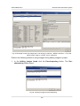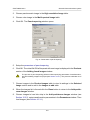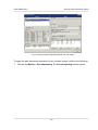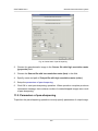
1
General information about system
PHOTOMOD 6.0.2
RPC (Rational Polynomial Coefficients) – is a sensor model commonly used to determine
the ground coordinates of pixels in high resolution satellite imagery;
TIN – Triangulation Irregular Network;
WGS – is a standard the World Geodetic System;
WMS – Web Map Service, is a standard protocol for serving georeferenced map images
over the Internet that are generated by a map server using data from a GIS database;
DB – data base;
UAS – Unmanned Aircraft Systems;
GIS – geoinformation system;
RSD – remote sensing data;
pix – pixels;
CS – coordinate system;
RMS – root mean square;
DTM – Digital Terrain Model.
1.5. Main conventions and terms
Through this User Manual various conventions and terms are used to describe processes
and objects, which are used in the system.
There are the following terms on a step of data collection for aerial triangulation:
• Workstation – personal computer (operators place) with installed system;
• Aerial triangulation – is the mathematical process of establishing precise and accurate
relationships between the individual image coordinate systems and a defined datum
and projection (ground);
• Block layout – approximate scheme of terrain, obtained using projecting of matched
images of a block on specified surface (Earth surface) considering images overlaps,
relative position, rotation by angles in a space.
• In-strip stereopair is formed by two adjacent images in a strip;
• Inter-strip stereopair is formed by two adjacent images from different strips;
7