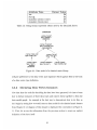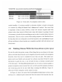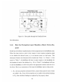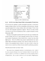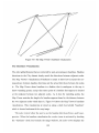
1
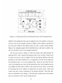
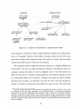
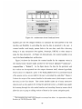
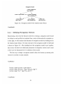
of 2000 and the data we have extracted from them.
2.1
The DataLink Server Maps Virtual Navigation
Hierarchies to Real Data
The DataLink Server implements a three-level abstraction of the physical data. The
topmost abstraction barrier is created by the presentation layer, which is the interface
that is visible to the user and is responsible for formatting the data provided by the
lower abstraction layers into HTML or other web-browsable content. The next level
beneath the presentation layer is the navigation layer which is where the navigation
hierarchies are defined. The navigation layer describes what data should be visible
to the presentation layer at any given point in the navigation hierarchy. It also
describes where a user can go to next from the current location in the hierarchy.
The navigation layer has a contract with the presentation layer such that it will only
provide navigation options for data which is physically present. In order to ensure
that this covenant is fulfilled, the navigation layer interfaces with the data layer in
order to resolve the mappings between the virtual data abstractions in the navigation
layer and real physical data in the dataset. The data layer describes the physical
hierarchy of the data and defines the attributesof each type of datum which might be
present in the dataset. Attributes are bits of information such as image resolution,
source sensor, date of acquisition or any other properties of which should be presented
as selections that the user can use to locate specific data.
Figure 2-1 depicts the interactions between the three abstraction layers of the
DataLink Server. As the figure shows, the navigation layer can be thought of as a
directed graph, or network, in which each vertex represents a specific location in the
navigation hierarchy. Leaf vertices, shown in Figure 2-1 as darkened circles, represent
physical resources in the dataset such as images, data files etc. All other vertices in
the navigation graph correspond to locations in the virtual navigation hierarchy and
may or may not be associated with locations in the physical data hierarchy. A content
30