1
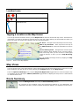
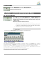
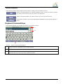
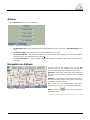
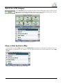
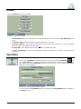
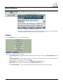
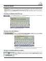
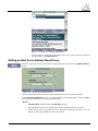
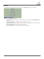
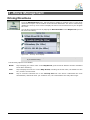
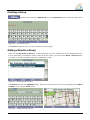
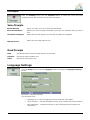
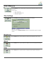
PHAROS DRIVE GPS 150
User Manual
Warranty Conditions
Manufacturer is not responsible for any product defects due to misuse, abuse, or usage of product in way that is
not in compliance with the written product instructions. To use this product other than expressed in the
instructions will void customer's product warranty.
Precautions and Notices
¾
¾
¾
¾
¾
¾
¾
¾
¾
¾
¾
¾
¾
¾
¾
¾
¾
¾
¾
¾
¾
¾
¾
Please do not attempt to remove the memory card from your Pharos Drive GPS 150. Removing the card will
break the seal and void the warranty.
Do not attempt to operate the GPS Personal Navigation Device (PND) in a vehicle while the vehicle is in
motion or in anyway that interferes with safe driving.
Secure your device to the vehicle in such a way so as to not endanger the driver or passengers while driving
or during operation.
Be attentive to roadway signage, all posted roadway information, and the condition of the road itself.
Calculated routes are for reference only; users must obey all traffic signs and local regulations.
GPS positioning is intended for use as reference, not precise measurement of direction, distance or
topography.
Do not place the device where it will block the driver’s vision.
Do not place the device where the airbags are located or where the airbags could deploy.
Do not place the device anywhere in the vehicle without securing it in the holder.
Do not place your device in any area of the vehicle where the use of electronic displays is prohibited in motor
vehicles.
Do not use the device in a wet location.
Do not use the device close to hot areas such as radiators, stoves, or other products that produce heat.
Do not leave the product in direct sunlight or heat for extended periods of time. Overheating the battery can be
dangerous and/or cause malfunctions.
Do not push objects of any kind into cabinet slots or other openings in product. Slots provided for ventilation
must not be blocked or covered.
Do not use product on unstable table, cart, stand, tripod or bracket. Any mounting of the product should follow
manufacturer’s instructions, and should use a manufacturer-recommended mounting accessory.
Use the correct external power source indicated on the electrical ratings label.
Handle battery packs carefully. Battery pack could burn or explode if handled improperly. Do not open, crush,
or puncture battery pack. Do not dispose of battery pack in fire or water, or expose battery pack to direct
sunlight.
GPS signals cannot pass through opaque solid materials. Obstacles, such as tall buildings, tunnels, dense
trees and bad weather can affect signal reception. Window tint that contains metallic material can affect GPS
signal as well. Cordless phones, radar detectors, satellite radio receivers, and other wireless devices may
also interfere with GPS reception.
To power on device, hold the power switch up to 5 sec until screen turns on.
It may take a few minutes to successfully acquire GPS signals when turning on the GPS device for the first
time. Complete this procedure in an outdoor open space. Whenever Reset is pressed, it turns the device off.
Map database may not cover one hundred percent of all areas and/or addresses listed.
This GPS PND may not be used for any purpose in which failure could lead to personal injury, physical, or
environmental damage.
Software version and user manual contents are subject to change without notices.
For more information regarding ActiveSync, please visit the ActiveSync website:
http://www.microsoft.com/windowsmobile/activesync/default.mspx
Pharos Science & Applications, Inc.
411 Amapola Avenue
Torrance, CA 90501-1478
www.pharosgps.com
Tel: 888-742-7678
i
Contents
1–
Getting Started
1
Configuration Wizard .......................................................................................................................... 1
Map Screen......................................................................................................................................... 3
Map Views .......................................................................................................................................... 4
Route Summary.................................................................................................................................. 4
Cancel Route ...................................................................................................................................... 5
2–
Select Location and Generate Route
5
Go to an Address................................................................................................................................ 5
Points of Interest (POI) ....................................................................................................................... 8
QuickNav .......................................................................................................................................... 10
Recent Place .................................................................................................................................... 11
Address Book ................................................................................................................................... 12
3–
Route Management
15
Driving Directions.............................................................................................................................. 15
Avoid Roads ..................................................................................................................................... 16
Detour ............................................................................................................................................... 18
Map Browsing ................................................................................................................................... 19
Walking Mode ................................................................................................................................... 19
Map Selection ................................................................................................................................... 20
4–
Settings
21
Settings Menus ................................................................................................................................. 21
Map Display ...................................................................................................................................... 21
Prompts............................................................................................................................................. 22
Language Settings............................................................................................................................ 22
Look & Feel Settings......................................................................................................................... 23
GPS Settings .................................................................................................................................... 23
Units of Measure............................................................................................................................... 24
Time Settings.................................................................................................................................... 24
Brightness ......................................................................................................................................... 24
About................................................................................................................................................. 24
Help................................................................................................................................................... 24
Index
25
ii
1 – Getting Started
Welcome to the world of mobile navigation! Simple operation, clear maps in 2D or 3D mode as well as
numerous innovative features and functions have made PHAROS GPS the essential guide for every
traveler – whether in the car, on foot or by bike.
Configuration Wizard
This wizard, which automatically starts the first time you use the device, lets you easily configure the system
settings by providing a step-by-step setup process. You can also configure these system settings by going to
the system options from the Settings menu.
•
Language Settings – Set text and voice language preferences.
•
End User License Agreement (EULA) – Please review the license information and tap the Agree
button. The EULA screen appears each time you use a new map.
•
Time Zone –You can select the Adjust to Daylight Savings checkbox to automatically adjust for
daylight savings.
•
Units of Measure – Specify the system measurement units.
•
Prompts – Configure the general navigation prompts and notifications.
•
Driver Warning – When you start the device, the Driver Warning screen appears. Please take a
moment to review the information provided before tapping the Agree button. Select the "Do not
display this warning again" checkbox to skip this message in the future.
Figure 1 – Map Warning Screen
1
2
Map Screen
You can use the icons displayed on this screen to view and receive information about your route.
1
6
2
7
8
3
9
4
5
10
Figure 2 – Map Screen
Map Screen Icons
1, 6
Zoom in or out of the map to view a larger and less detailed area, or a smaller area in
greater details.
2
Tap the compass to change the map view display as follows:
2D map view with the forward direction at the top.
3D map view with the forward direction at the top.
2D map view with North at the top.
3
Tap this icon to adjust or mute the volume.
4
When you have calculated a route, the Directions Bar
displays information about your next turn. Tap this bar for a
complete list of turn-by-turn directions.
5
The Information Bar is a toggle button that displays the
remaining travel distance and travel time, estimated time of
arrival, street name and address number, speed and altitude.
7
The red GPS receiver means that a reliable GPS signal is not yet located.
The green GPS receiver means that a reliable GPS signal is located and that you are
ready to navigate.
8
These icons display your power source.
9
Tap this icon to set your QuickNav location. When set, you can tap this button to
automatically calculate a route to this location.
10
Tap this icon to display the Main Menu.
3
Location Icons
Current location in Vehicle Mode or Walking Mode.
Last known location when GPS signal is unreliable.
Generated route
Tapping a Location on the Map Screen
You can tap a desired location directly on the Map Screen in both the 2D and 3D map views. This feature is
useful when you want to navigate to a specific point on the map, rather than by the street address. When you
tap on the map, the Popup menu appears with the following options:
Go There – Navigate to the selected point on the map.
Add to my Favorites – Save a point on the map to
the Address Book as a favorite destination for future
use.
Set as Starting Point – Designate the selected point
as the starting point instead of your current location.
This works only when you do not have a GPS signal
(such as indoors) or when you are in Map Browsing
mode.
You can disable the Popup menu by tapping the Map
Display button.
Figure 3 – Point on the Map Options
Map Views
You can choose to see a two-dimensional or three-dimensional map adjusted specifically for day time or night
time conditions. 2D and 3D can be set by tapping the Compass button on the Map Screen.
From the Options & Settings menu, tap the Day View/Night View toggle button to view the map for day
or nighttime driving and tap the 2DView/3D View toggle button to display the map view in 2-dimensional
or 3-dimensional views.
Route Summary
From the Manage Route menu tap the Route Summary button.
An overview of your complete route, the total driving distance to your destination, the
estimated travel time, and the complete destination address, are displayed on the screen.
4
Cancel Route
From the Manage Route menu tap the Cancel Route button.
The current navigation stops and the GPS clears the route. You can only cancel a route
after a destination has been set.
2 – Select Location and Generate Route
Go to an Address
From the Go menu, tap the New Address button. The Enter address screen
appears, allowing you to choose how you want to enter address information. For
example, if you select City first, the first address screen is lets you select from a
list of cities, the second screen a list of streets, and the third screen lets you enter
an address number.
Select from the following address entry options:
•
City first – State > City > Street > Address Number
•
Street first – Street > City > Address Number. Here you can enter a street
name without having to first select a city. This is useful when searching for
an address in a metropolitan area where there are many cities and towns.
•
Intersection –City> Street > Intersecting Street
Note: When a United States map is selected, the first address screen is always
Enter State.
Tap from one of the Enter address options to display the first address screen.
Figure 4 – Selecting an Address
When entering an address using the keyboard, the characters appear in the Address field. The device
automatically searches the Address list for the first occurrence of the entered characters. After you have
selected a city, the device requests the next part of the address, such as street and address number.
You have the option of selecting the City Center instead of entering a street. City Center is the default that
shows above the keyboard before you start entering street letters.
If you don't know the address number, you can select the Street Midpoint.
Tap the OK button to move through the sequence of address screens.
5
Toolbar Buttons
The following toolbar buttons appear at the bottom of many of the navigation screens.
When you tap this button for a selected address, group, or place, the device accepts
the choice and moves to the next screen in the sequence.
When you tap this button, the device returns you to the previous screen.
This button provides a list of command options available for the selected address or
place.
Keyboard Command Keys
The following buttons are available to enhance your search process.
1
2
3
Figure 5 – Search and Keyboard Buttons
1
Lets you remove a character that you have entered.
2
Lets you scroll up or down the list of city or street names.
3
Tap the keyboard button to display the keyboard when it is hidden. Tap the See List button to hide the
keyboard and see/scroll longer lists of address results.
6
Actions
Tap the Actions button to use an address:
Figure 6 – Actions for Addresses
•
As Starting Point, which designates the selected address as the route origin (Map Browsing mode
only).
•
To Show on Map, which displays the selected address on the map.
•
As saved address – Tap to add an address to your list of favorite locations. For more information
about favorites, see Address book on page 13.
•
To see information – Tap to display additional address information and phone number (where
available).
Navigate to an Address
The final step in the address entry is the GO
screen. Here you can validate your address and
you can select from the following route types:
Quickest – This option selects the route that takes
the least amount of time. Quickest is the default
setting.
Shortest – This option selects the route that is
shorter in distance. Note: The shorter route may
not always be the quickest.
Go – When you tap the Go button, the device
calculates the route to your selected destination.
Figure 7 – Show on Map
Demo – Tap the
simulated route.
icon to start navigating a
7
Points of Interest (POI)
The Points of Interest (POI) list is a collection of thousands of interesting or
useful places organized by easy-to-find categories. For example, you can use
this device to guide you to a shopping center, hotel, restaurant, or gas station.
Many categories have subcategories to provide for an even greater list of
choices. For example, gas station may have many subcategories each
representing a particular brand name. The same is also true for hotels.
Restaurants have subcategories that represent different types of food, such as
Indian, Italian, and French.
Search for a Location Near You
You can determine the area where you want to search for a specific place, such as a gas station, hotel, or
restaurant. Where I am is automatically selected.
Tap to search near your current location. This is the default.
Tap to search near your specified destination. If a destination has not been selected
and a route generated (by tapping the Go button), this button is disabled.
Tap to search for a POI in another location. This button opens the Address Search
Mode screen, which is described on page 6.
Search for a POI Name
Tap this button to display the Search POI keyboard screen, where you can search by
entering text in the POI Name field. The Smart Search System automatically displays
the POI names that match the characters entered. This device automatically displays
the POI entries and the distance each entry is from your current location.
For example, if you enter “Avis” and tap the Search button. This device displays all Avis
entries as shown in the figure below.
Figure 8 – Search by POI Name
8
Search for a POI Category
Tap the Browse button to display the most common POI groups. Many of these groups
will include several POI categories, which in turn my contain subcategories. Tap the
More button to go straight to the full list of POI categories.
Figure 9 – Most Common POI Categories
Show or Hide Symbol on Map
You can show or hide the POI symbol on the Map Screen by checking or clearing the checkboxes next to a
POI category or subcategory. For example, you can choose to show only French restaurants on the Map
Screen.
Figure 10 – Showing a POI Symbol on the Map
9
Actions
Tap the Actions button to use a POI:
Figure 11 – Actions for POIs
•
As Starting Point, which designates the selected address as the route origin (Map Browsing mode
only).
•
To Show on Map, which displays the selected address on the map.
•
As saved address – Tap to add an address to your list of favorite locations. For more information
about favorites, see Address Book on page 13.
•
Sort by ABC, which displays the category entries in alphabetical order.
•
To see information, which shows additional address information and phone number (where
available).
QuickNav
icon
You can set a QuickNav destination so that every time you tap the QuickNav
on the Map Screen, the device automatically calculates the route to this destination for
you. When you tap the QuickNav button for the first time, you can select a predefined
address or a POI category.
Figure 12 – Setting the QuickNav Location
You can change the QuickNav settings by tapping the Set QuickNav button located on
the Setup 1 menu.
10
Recent Place
From the Go menu, tap this button to select an existing location from a list of
locations that you have previously traveled to.
Figure 13 – Traveling to a Recent Location
This device automatically stores the last 64 locations in memory. After 64 locations
have been saved, the older location entries are erased.
Actions
Tap the Actions button to use a recent location:
Figure 14 – Actions for Recent Places
•
As Starting Point, which designates the selected address as the route origin (Map Browsing mode
only).
•
As saved address – Tap to add an address to your list of favorite locations. For more information
about favorites, see Address book on page 13.
•
Delete Item, which deletes an entry from the Recent Locations screen.
•
Clear List, which clears all locations in the Recent Locations screen.
•
To see information – Tap to display additional address information and phone number.
11
Address Book
A Favorite is an address or POI that you have stored for easy retrieval. Save favorite addresses to your
Address Book and later you can easily travel to these destinations. Favorites can be saved by using the
Actions button within the New Address, Recent Places, and POI entry screens. By default your favorite
will be placed into the Favorites group. You can also create your own custom groups; e.g. for a city or
activity.
Creating an Address Book Group
From the Address Book screen, tap the Actions button to add, edit, or delete groups.
Enter a group name and select a group icon.
Figure 15 – Adding a Favorites Group
Saving a Favorite Address
Within the New Address, Recent Places, or POI screens, tap the Actions
button and then tap the As saved address button. Select the group to which
you want to add your favorite address.
Figure 16 – Adding a Destination to your favorites
The My Favorites group is the default group where all favorites are stored if
not assigned to a custom group. This group cannot be deleted.
Going to an Address Book Location
From the Go menu, tap this button to display the screen containing your
favorite addresses. Select a group, for example Restaurants. The device
displays a list of stored locations within the group. Select a favorite address and
tap OK.
12
Figure 17 – Going to a Favorite Destination
You can check or clear the checkmarks next to any group to show or hide the
group symbol on the Map Screen.
Setting an Alert for an Address Book Group
Alerts let you know that you are within a certain distance of an item in an Address Book
group.
Figure 18 – Setting Your Favorite Alerts
Use the right and left scroll arrows to set the distances for the 1st and 2nd Alerts.
In the Set Alert Distances screen, you can disable an alert by setting the 1st Alert to Off or
by clearing the checkbox next to the selected group.
Notes:
•
Favorite Alert settings affect all Favorites groups.
•
The 2nd Alert must be set to sound at a closer distance than the 1st Alert.
•
Alerts can be set for a group but not for individual locations. Of course, you can
always create a group that has just one location.
13
Actions
While highlighting a favorite address within a group, tap the Actions button to use the address:
Figure 19 - Actions for Address Book
•
As Starting Point, which designates the selected address as the route origin (Map Browsing mode
only).
•
To preview on map, which displays the selected address on the map.
•
Edit a Fav. Location, which changes the name, comment, or group location for the selected address.
•
Delete Fav. Location, which removes the selected address.
•
To see information, which displays additional address information.
14
3 – Route Management
Driving Directions
From the Manage Route menu, tap this button to display a complete Turn-by-Turn list of
directions from your current location to the selected destination. The device continuously
updates the Turn-by-Turn screen to display the most current instructions as you navigate
the route.
You can also reach this screen by tapping the Directions Bar on the Map Screen (second
bar from the bottom).
Figure 20 – Turn-by-Turn Display
Note: The first turn is at the top of the list and the final turn is at the bottom, identified
by a checkered flag.
The following options are available:
Route
Tap to display your entire route on the Map Screen, plus the travel distance and the estimated
travel time remaining.
Turn
Tap to display the next turn on the Map Screen, including the street name, the distance to the
turn, and the turn direction.
Avoid
Tap to avoid the selected turn in the Turn-by-Turn list. The device recalculates the route
automatically. Note that when you exclude a turn, the recalculated route may take longer.
15
Avoid Roads
You can specify that certain types of roads be permanently excluded from your route
calculations, and you can create your own list of specific roads to avoid. Use this feature
when you want to avoid congested roads, toll roads, or unsafe streets.
From the Manage Route menu, tap the Avoid Roads button. The Avoid Roads screen
appears, displaying predefined road groups.
The GPS provides the following predefined road
groups:
•
Ferries – The default value is to avoid
•
Gated Communities – The default value is
to allow
•
Highways – Roads that allow for high
volume, maximum speed traffic movement
between and through major metropolitan
areas. The default value is to allow
Figure 21 – Predefined Road Groups
•
My Roads to Avoid – This is a default folder
that lets you store roads to avoid. You can
display the items in this folder and allow or
avoid specific roads. The default value is to
avoid
•
Toll Roads - The default value is to avoid
To allow or avoid a predefined road group:
•
Select a predefined group and tap the
Allow/Avoid toggle button, then tap the
Back button. The next time you calculate a
route, the device calculates a route based on
your avoid or allow selections.
Note: predefined road groups (Highways, etc.) are
allowed or avoided as an entire group. You
cannot allow or avoid individual toll roads,
highways, or ferries.
16
Creating a Group
Tap this button and select Add Group. From the Add Group screen, enter the group name
and tap OK.
Figure 22 – Add a Road Group
The Actions screen also lets you edit or delete a selected group.
Adding a Road to a Group
When you tap My Roads to Avoid or a road group that you have created, the device displays the group
screen, which lets you designate roads to avoid. From this screen, you can use the Allow or Avoid buttons
to include or exclude individual roads when calculating a route.
Figure 23 – Storing Road Locations
Tap Actions and then the Add Road button. Select the city and street. The road is displayed on the Show
on Map screen. Tap the Avoid button.
Figure 24 – Adding a Road to Avoid
17
Actions
Tap the Actions button:
•
Add Road – Tap to add a new road to avoid to a group.
•
Edit Road – Tap to rename the road and/or select a different group. When you have made your
changes, tap Save.
•
Delete Road – Select a road and tap this button to remove the road from your group. The GPS no
longer avoids the removed road.
•
Show on Map – Tap to show the map with the displayed destination for you to review before creating
a route.
•
To see information – Tap to display the location’s address information.
Detour
From the Manage Route menu, tap the Detour button. The Detour screen lets you
instruct the GPS to create a detour to avoid a road event, such as an accident.
Figure 25 – Avoiding a Road Event by Performing a Detour
Select the Detour distance for which you want to generate a detour. For example, if you are traveling on a
major highway and you are alerted by the news that there is traffic for the next 2 miles, you can have the device
calculate a detour that takes you off the highway and then returns you back to the highway after a distance of
2 miles.
18
Map Browsing
You can browse the map without a GPS signal. From the Settings
menu, tap Map Browsing button to disconnect from the GPS receiver.
Figure 26 – Explore the Map
The
icon identifies your current position. You can use the arrow cursor to move the map. When you have
located the street destination, you can tap that point on the map. On the popup menu tap Go There to
navigate to the selected point. You can also set an address as an origin so that you can preview a route.
You can reconnect to GPS by tapping the bottom bar on the Map Screen or by tapping the GPS Navig.
button on the Settings menu.
Walking Mode
Walking Mode lets you travel as a walker, generating a route up to
ten kilometers (6.2 miles), which is not limited by vehicle constraints such as one way streets. When creating
a Walking Mode route, the GPS avoids highways or other roads where walkers would not travel. Voice
prompts are deactivated in this mode.
From the Settings menu, tap the Walking Mode button. You can switch back to Vehicle Mode by tapping
the Vehicle Mode button.
Note: When Walking Mode is selected, Driving Directions, Route Summary, Avoid Roads, and Detour
features are disabled.
19
Map Selection
All US regional maps switch automatically as you travel or as you set an address origin or
destination. From the Setup 1 menu, tap the Select Map button to change the selected map to another
map.
Figure 27 – Select a Map
You can also choose from the following Select Map commands:
•
Refresh – Tap to refresh the screen.
•
Delete – Tap to permanently remove a selected map.
Note: You cannot delete the map you are currently using.
20
4 – Settings
Settings Menus
From the Main Menu, tap the Settings button to configure the system settings.
Map Display
From the Settings menu, tap the Map Display button to select from the map interface
options listed below.
You can choose the following options for the Map Screen:
Forward up
Orients the map so that the direction you are traveling is always at the top of the
screen.
Use Larger Labels
Increases the size of street names to make the map easier to read.
Popup Menu
Displays the navigation popup menu when tapping on a map location. If you
disable the Popup menu, tapping the screen will bring you to the Main Menu.
Use Automatic Zoom
When selected, the zoom is speed dependent. The map zooms out at higher
speeds, displaying a larger map area, and zooms in at slower speeds, displaying a
smaller map area.
Maneuver Diagram
Displays a large image that indicates your next maneuver, such as left turn or right
exit.
Next Street Bar
Displays the next street name.
Zoom buttons
Displays zoom in and zoom out buttons.
Compass
Displays the compass, which lets you change the map view display:
•
2D map view with the forward direction at the top
•
3D map view with the forward direction at the top
•
2D map view with North at the top
QuickNav Button
Displays the QuickNav button, which you tap to navigate to a pre-selected
location
Volume Control
Displays the Volume Control bar.
GPS Indicator
Displays whether a reliable GPS signal has been located.
Power Indicator
Displays if your device is plugged in or running on battery power.
Information Bar
Displays estimated time of arrival.
Menu Button
Displays the Menu button, which opens the Main Menu. If you disable the Popup
menu, tapping the screen will bring you to the Main Menu.
21
Prompts
From the Settings menu, tap the Prompts button to select the voice and road
notifications that you would like to use while navigating.
Voice Prompts
Speed Warning
Warns you when your car exceeds the speed limit.
Route Recalculation
Notifies you when the GPS recalculates your route. For example, when you miss a
turn.
Unreliable GPS Signal
Warns that the GPS signal is too low and unreliable for navigation.
GPS Not Found
Alerts you if the GPS signal is lost.
Road Prompts
Both
Announces both the street number and the street name.
Numbers
Announces street numbers only.
Name
Announces street name only.
Language Settings
From the Setup 1 menu, tap the Language button to display the Language Settings
screen.
Figure 28 – Language Settings
You can select from:
•
Language Text – sets the language used for map and menu labels
•
Voice Guidance – sets the language used for voice prompts and voice directions
•
Say Road Name – instructs the device to say road names versus simple turn
instructions
22
Look & Feel Settings
From the Setup 1 menu, tap the Look & Feel button to select from a list of preinstalled
skins. It is common that your unit may have only one skin supplied. A skin determines the
visual effects such as colors and icons displayed.
•
Prefer QWERTY Keyboard – When this option is selected, the navigation
keyboard is displayed as a computer keyboard (QWERTY style) on the screens.
When unselected, the keyboard keys are arranged in ABCD format.
•
Auto Day-Night Adjustment – When this option is selected, the device
automatically switches between day and night view according to the GPS time
and date information provided. If this option is selected, but you manually switch
the day /night view, it will remain in that mode you selected until the next time
the device automatically switches the day /night view.
GPS Settings
From the Setup 2 menu, tap the GPS Signal button to display GPS information.
The device receives data from a built-in GPS receiver to pinpoint your location. Your
vehicle's location and position are constantly updated unless you are working in the
Browse Map mode. The GPS receiver may take a few minutes to find its initial location.
For best results, ensure that the GPS receiver has a clear view of the sky.
The GPS Signal screen displays the following information:
•
Longitude
•
Latitude
•
Speed
•
Altitude
•
Number of Satellites
If you are working in the Browse Map mode, the device automatically disconnects from the GPS receiver.
GPS Troubleshooting
Signal too low
When you first start the GPS you may hear the “Signal too low” message. This message means that your
navigation device hasn’t yet located a reliable GPS signal. Check that your device is connected to a power
source, such as the cigarette lighter, and has a clear view of the sky. You will almost always have too low a
GPS signal when you are indoors.
23
Units of Measure
From the Setup 1 menu, tap this button to specify the measurement system you would
like to use.
You can select:
•
Miles, Yards (UK)
•
Miles, 10th of a Mile (US)
•
Kilometers, Meters
Time Settings
From the Setup 1 menu, tap this button to display time settings.
Figure 29 – Time Zone
You can select the Daylight Savings checkbox to automatically adjust for daylight
savings.
Brightness
From the Setup 2 menu, tap this button to determine the brightness of the screen.
About
From the Setup 2 menu, tap this button to displays version and copyright information.
Help
From the Setup 2 menu, tap this button to displays technical support information.
24
Index
A
Add to My Favorites • 13
Adding a Road to Avoid • 17
Alerts for a Favorite Group • 13
Avoid Roads • 16
B
M
Main Map • 3
Main Map Icons • 3
Map Browsing • 19
Map Selection • 20
Map Display • 21
Map Views • 4
N
C
Cancel Route • 4
Configuration Wizard • 2
Creating Group • 17
D
Configurations • 21
Screen Buttons • 6
Detour • 18
Driving Directions • 15
F
Navigate to an Address • 7
P
Walking Mode • 19
POI category • 9
POI Name • 8
Points of Interest (POI) • 8
Prompts • 22
Q
QuickNav • 10
Favorite Locations • 12
G
Go to an Address • 5
Going to a Favorite Destination • 12
GPS Settings • 23
GPS Troubleshooting • 23
Groups • 13
H
Help • 26
I
R
Recent Locations • 11
Road Prompts • 22
Route Overview • 4
S
Save a Favorite Location • 12
Search for a Location Near You • 8
Search for a POI category • 9
Search for a POI Name • 8
Select Location and Generate Route • 5
Show or Hide Symbol on Map • 9
T
Introduction • 2
K
Keyboard Command Keys • 6
Technical Support • 26
Time Settings • 24
Tutorial • 2
U
L
Language Settings • 22
Location Icons • 4
Location Point on Main Map • 4
Look & Feel Settings • 23
Units of Measure • 24
V
Voice Prompts • 22
25
Warranty Conditions
Manufacturer is not responsible for any product
defects due to misuse, abuse, or usage of product
in way that is not in compliance with the written
product instructions. To use this product other than
expressed in the instructions will void customer's
product warranty.
Pharos Website:
www.pharosgps.com
Pharos Customer Care Center:
1.888.742.7678
26