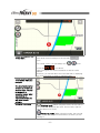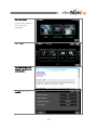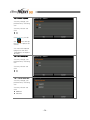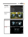
1
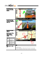
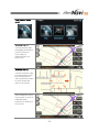
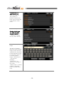
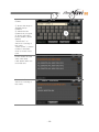
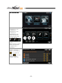
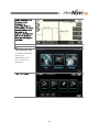
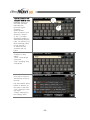
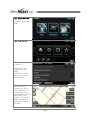
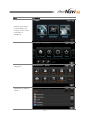
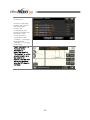
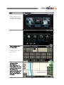
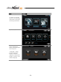
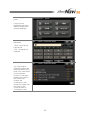
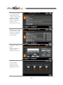
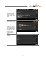
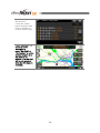
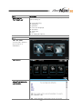
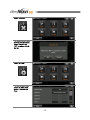
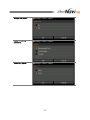
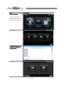
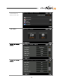
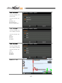
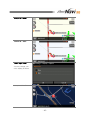
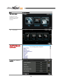
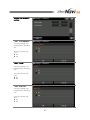
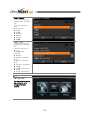
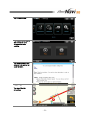
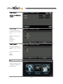
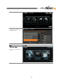
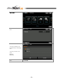
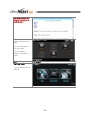
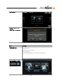
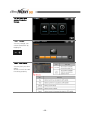
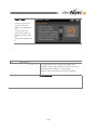
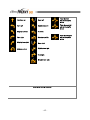
SpeedNavi SQ™
USER MANUAL(Union)
Imprints
M&SOFT Inc.
th
11 floor Samju bldg, 1,
Nonhyun-dong, Gangnam-gu,
Seoul, Korea.
The information contained herein may be changed at anytime without prior notification.
This manual or any parts thereof may not be reproduced for any purpose whatsoever
without the express written consent of M&SOFT Inc., nor transmitted in any form either
electronically or mechanically, including photocopying and recording. All technical
specifications, drawings etc are subject to copyright law.
ⓒCopyright 2009, M&SOFT Inc.
All rights reserved.
-1-
Table of Contents
0. BEFORE GETTING STARTED
0-1. Legal Notification
0-2. Safety Notification
0-3. Useful Information
0-4. Registering Your Product
1. QUICK GUIDE
1-1. Understanding screen features
1-2. Finding a destination
1-3. Using advanced features
2. SPEEDNAVI SQ™
2-1. Understanding the software
2-2. Map
2-3. Destination
2-4. Settings
2-5. System
2-6. Symbols
3. INSTALLATION
4. SUPPORT
5. EULA (End User License Agreement)
-2-
3
3
3
3
4
4-10
4-7
7-9
9-10
10-65
10-14
14-15
16-34
35-59
59-61
61-65
66
67
68-70
0
BEFORE GETTING STARTED
Before to start using SpeedNavi SQ™, please make sure you understand all the notifications
as well as information provided below for your own safety. M&SOFT Inc. recommends
you to read all the notifications for proper and easy use of the software and to read information
to have a better understanding of navigation in use.
0-1
LEGAL NOTIFICATION
IMPORTANT!
LIABILITY
The software and documentation are subject to change without
notice. M&SOFT Inc. is not liable for the accuracy of the
information contained in this manual or for damages resulting
from the use of this manual.
IMPORTANT!
TRADEMARKS
All brands and trademarks mentioned in this document are
possibly registered by third parties and are subject to the
current legislation and to the rights of their respective owners
without reservation. All mentioned names of products,
societies, or brands may be registered trademarks of their
respective owners.
0-2
SAFETY NOTIFICATION
CAUTION!
DO NOT operate while driving. Operating the system while
driving may result in a dangerous situation.
CAUTION!
DO NOT look at the display unless it is absolutely safe to do so.
Loosing attention while driving may cause a dangerous
situation.
CAUTION!
FOLLOW TRAFFIC REGULATIONS. Traffic regulations have
priority over any instructions given by the system. Real driving
environment may differ from the system.
0-3
USEFUL INFORMATION
NOTE!
It is important for you to have latest version of SpeedNavi SQ™
to have a safe and accurate use of the system. You may check
related information as well as its schedule regularly from the
web. (http://www.speednavi.com)
NOTE!
GPS reception has error range according to the geographical
features as well as climates. By this reason, in some cases, the
route guidance may result in a minor difference. In such case,
you may stop your vehicle in a safe and wide open place to let
GPS lock satellite’s location properly. When GPS signal is low
in general, please visit your local device representative to solve
the problem.
NOTE!
In order for you to use TRAFFIC MESSAGE applied to
SpeedNavi SQ™, ask your local device supplier for a proper
use. In some countries, you are asked to pay for the
information use as well as for the data receiver.
-3-
0-4
REGISTERING YOUR PRODUCT
Registering product
Input the license key given at
www.speednavi.com and
your software serial number
composed of 16 digits on
the enclosed sticker in the
CD or the manual.
1
QUICK GUIDE
Quick guide gives you an easy and fast way of understanding SpeedNavi SQ™ in general.
Please read through the chapter 2 SpeedNavi SQ™ to have a better understanding in use of
the software. In this quick guide, information is related to frequently questioned features only.
1-1
What you will see when
you turn the system on.
UNDERSTANDING SCREEN FEATURES
When you see this
screen, the system is
booting to start the
SpeedNavi SQ™. Wait
and the screen will be
changed automatically.
-4-
This is the Warning
screen .
Read conditions and
information carefully
and tap l Agree l to
accept the conditions
and information.
(Searching) Selection of
states.
You need to select the
states when the map
program is firstly
started. You can also
change states when
you searching cities in
other states.
This is the main screen
you will always use.
SpeedNavi SQ™ gives
a simple menu structure
for an easy use of
navigation. You may
browse map and set a
destination on the map,
find a destination by
various methods or
manage your own
settings.
-5-
This is what you will see
in Map menu
Zoom level control is always on the top with
icons.
In a normal screen, you will always see
icons
icon above.
on left and
These icons give you more information as well as useful
features.
At bottom, you will see Menu and a text bar that is displaying
your current position in street or regional name.
This is what will appear
in the screen while you
navigate.
The street name on top
is where your next turn
shall be made. You will
be guided in a
separated screen when
approaching an
intersection where you
will make turns in
advance.
Changing view mode
[
North up mode] When using this mode, the top side of
your screen will always be the north. (left for west, right for
east and bottom for south)
[
Heading up mode] When using this mode, the top side
of your screen will always be the direction of where you are
heading to
-6-
Finding my position
[
3D in Heading up] When using this mode, the screen
will have your Heading up mode in 3D graphic to give you
closer look of real driving environment.
While browsing map, sometimes you won’t be able to
remember your current location. Just tap on
icon
on the screen if you wish to view or change screen back to
your current position. This icon won’t be displaying unless
you browse the map other than your current position.
1-2
Tap “Destination”
FINDING A DESTINATION
You may find a
destination using “Map”
also. Please refer to
detailed “Map”
guidance in later
sections.
Tap “Address”
You may use other
types of finding a
destination also. Please
refer to detailed
“Destination” guidance
in later section.
-7-
Please input the name
of road you would like
to find.
A list of roads will
display on the screen
including typed road
name.
Select the correct road
name you wanted to
search.
Select the City which
includes the road you
have chosen.
Input the house number.
-8-
Tap “Destination”.
To change the routing
options,.
Tap “ Route.”
Choose one routing
option and follow the
route guidance to your
destination.
1-3
MAP
USING ADVANCED FEATURES
You may use “MAP” to browse map, find a destination, via
points or find and save a favorite place as your own POI’s
(My Point)
To use or learn this feature, tap on “MAP” from the main
menu.
MY POINT
You may save a place as one of “MY POINT” which is same
as creating your own POI’s for a favorite place.
-9-
To use or learn this feature, tap on “DESTINATION” from the
main menu and go to page 2/2 and tap on “MY POINT”
2
SPEEDNAVI SQ™
In this chapter, you may find all the necessary information regard to using SpeedNavi SQ™.
2-1
How is the menu
structured?
UNDERSTANDING THE SOFTWARE
SpeedNavi SQ™ consists of 3 main menus, [MAP],
[DESTINATION] and [SETTING]
Main Menu
MAP
DESTINATI
ON
SETTING
Sub Menu
Address
Recent
My Point
POI Name
City Center
Nearby
Coordinates
Theme
Route
Display
Guidance
Language
Simulation
Time Zone
Unit
Others
Tracks
Reset
- 10 -
ZOOM CONTROL
You have 15 different
zoom levels to choose
from. Adjust your zoom
level by pressing
icons.
MY POINT
You can save a place
as your own POI by
icon. Tap
using
on the place from the
map and tap on
icon. You may save this
place in a several
different categories.
You may search this
saved place as a
destination from your
“MY POINT” list for later
use.
GPS STATUS
When you have
icon on the screen, it
means your GPS is NOT
working properly.
When this happens,
make sure your device
is in a open area for a
while. Please ask your
device supplier if it is
still not working.
No GPS
Unstable GPS
Normal GPS
- 11 -
VIEW MODE
You may change your
view mode by tapping
on
icon.
North up
Heading up
Heading up
(3D)
Where will you find all
the menus?
icon
Tap the
and you will find the
main menu.
When you wish to move
back to your current
position?
icon to
Tap
move back to your
current position while
you are browsing map.
Once you are back on
your position, the icon
will disappear
automatically.
When you wish to know
how fast you are
driving?
Your speed calculated
by GPS is displayed
right above of the
“
”.
- 12 -
CURRENT POSITION
(Street name in Text)
Your current position
will be displayed by
street name in text at
bottom of your screen.
2
What is the guide
information on the
screen?
3
①The first turning
information ②the street
name you will make
turn. ③the second
turning information
1
SPLIT SCREEN VIEW
GUIDE
When you are
approaching a turning
point, the screen will be
divided into 2 sections
to give you more
specific guidance.
① Example of Split
screen on the driving
normal road.
② Example of Split
screen on the driving
entrance of highway.
- 13 -
③ Example of Split
screen on the driving
highway.
○
4 Example of Split
screen on the driving
entrance of highway or
branch off.
INDICATAORS WHILE
DRIVING
When you are driving,
there are useful
indicators on map
display.
1
○
2
○
3
○
Tog
gle
1
2
Tuning Point
Remaining
distance to the
turning point
Remaining
distance to the
destination
Time
Remaining
2-2
What does the “MAP”
do?
3
MAP
The “MAP” is one of main menu which gives you feature to
▶ Browse map
▶ Find a destination, Way point(or Via point) from the map
▶ Find a destination from the map to save it as “MY POINT”
- 14 -
From the main menu,
select
Browsing map (1)
You may browse map
by tapping the direction
from the screen to
move map to a
particular place you
wish to see
Browsing map (2)
You may move the map
by pressing the screen
by a few seconds to
call out direction arrows
to move around the
map on the screen.
Searching a destination
Find a place to set as a
destination/way
point/set car position to
find a route
- 15 -
2-3
What does the
“DESTINATION” do?
Destination
The “DESTINATION” is one of main menu which gives you
the option to find a route to a destination by various different
methods such as;
▶
▶
▶
▶
▶
▶
▶
▶
Address
Recent
My Point
POI Name
City Center
Nearby
Coordinates
Theme
How this menu is
structured?
2-3
Main Menu
DESTINATION
-1. Address
Tap “DESTINATION”
Address searches
routes to a destination
using address.
- 16 -
Sub Menu
Address
Recent
My Point
POI Name
City Center
Nearby
Coordinates
Theme
Tap “ADDRESS”.
Type a name of Road
that you wish to find.
Press “Search”
when input is
completed.
1
① Show you the
[111]number
represents number of
data matching with the
input. ② Delete the last
character you typed. ③
Showing the next valid
character matching with
previous character
(Quick Speller).
2
3
“State:CA”: You can
change other states.
“Clear”: Erase the road
name.
“ABCDEF”:Changing
positions of the keys on
the keyboard.
“123”: Changing type
of keyboard.(English
character, number,
Latin)
- 17 -
Tap the one you
were looking for.
The numbers in
brackets indicate that
there are more than two
roads with the same
name.
Select the City.
Showing the list upto
two Cities that were
selected recently.
“Keyboard”: Typing
the City name directly.
Select house number
range.
This will only appear
when the house number
range is more than two,
otherwise this step shall
be automatically moved
to next step. If there is
no house number
range, it will show you
“ No House #”
message.
“Intersection”: to
search for crossing of
two roads.
“Road Center”: If house
number is unknown,
move to center of the
road.
- 18 -
2
1
Type the house
number.
① Shows the range of
available house
numbers.
② Delete the last
number that you typed.
③ Shows next valid
house number. (Quick
Speller)
“Intersection”: to
search for crossing of
two roads.
“Road Center”: If house
number is unknown,
move to center of the
road.
Shows when the same
house number and the
same road name.
It will appear when it is
more than two.
3
“Intersection”: to
search for crossing of
two roads.
- 19 -
Press “Destination” to
find route to the
destination or
press ”Way Point” or
“Car Position” to set the
selected location as a
way point or car
position (“Set Car Pos”
will be only appeared
when the GPS signal is
not fixed).
2-3
Tap “DESTINATION”
-2. RECENT
Recent searches routes
to a recently searched
destination from your
current location.
Tap “RECENT”.
- 20 -
Tap the one you are
looking for.
Choose the one from
the list. You can
delete one by tapping
icon.
see detailed information
icon
by tapping
and delete the list by
tapping “Delete
Press “Go” to find
route to the destination
to set
or press
the selected location as
a way point or car
position. (“Set Car Pos”
will be only appeared
when the GPS signal is
not fixed).
2-3
-3. My Point
- 21 -
Tap “DESTINATION”
① Favorite 1:
Registered by user.
② Favorite 2:
Registered by user.
③ Favorite 3:
Registered by user.
Once Favorites are
saved from the map,
you can see the
1
2
Icon on the bottom left
corner.
When pressed, location
will be automatically
recognized as a
destination.
Choose the one from
the list. You can
delete one by tapping
icon, rename by
tapping
icon and
delete the list by
tapping “Delete All.”
- 22 -
3
Press “Destination” to
find route to the
destination or
press ”Way Point” or
“Car Position” to set the
selected location as a
way point or car
position. (“Set Car Pos”
will be only appeared
when the GPS signal is
not fixed).
2-3
-4. POI NAME
Tap “DESTINATION”
POI Name searches
routes to a
destination from
POI’s (Point of
Interests).
Tap “POI NAME”
- 23 -
Type a name of POI
that you wish to find.
1
Keyboard shows you
next valid character
matching with
previously typed
character.
(Quick Speller)
Type the name of POI
and press “Search”.
① The [ ] number
represents number of
data matching with the
input. You will see[***]
when matching output
is over 200 POI’s.
② Delete the last
character that you
typed.
“State:CA”: You can
change it to other
states.
“Clear”: Erase all the
road name.
“ÁÇÈ“:Changing array
of keyboard.
2
If you select one of
those POI, it moves to
actual place of POI on
the map.
POI data shall be listed
based on distance on
the center of the map.
“City”: filtering it in the
City order.
“Categ”: Filtering it in
the Category order.
- 24 -
“City” filter
Showing only Cities
matching the input.
“Category” filter
Showing only Category
matching the input
Press “Destination” to
find route to the POI or
press ”Way Point” or
“Car Position” to set the
selected location as a
way point or car
position. (“Set Car Pos”
will be only appeared
when the GPS signal is
not fixed).
2-3
-5. City Center
- 25 -
Tap “DESTINATION”
it searches Cities in the
States.
Tap “City Center”.
Select the City you want
to search for.
“States: ON”: Can
change it into other
states
“Keyboard”: Directly
typing the city name
(Quick Speller).
Press “Destination” to
find route to the
location in the City or
press ”Way Point” or
“Car Position” to set
the selected location as
a way point or car
position. (“Set Car Pos”
will be only appeared
when the GPS signal is
not fixed).
- 26 -
2-3
Tap “Destination”.
-6. Nearby
Searching POI which
located nearby your
location on the screen
and based on
Categories.
Tap “Nearby”.
Select the type of
categories.
You can have more
Categories by tapping
“Other…”.
- 27 -
Select the one you want
to search for.
Direction is the angle
between the center of
the current map
location and
coordinates of POI.
Distance is length from
the center of the
current location to
coordinates of POI.
“Distance”: To arrange
list by distance.
“Alphabet”: To arrange
list by name.
Press “Destination” to
find route to the
Destination or
press ”Way Point” or
“Car Position” to set the
selected location as a
way point or car
position. (“Set Car Pos”
will be only appeared
when the GPS signal is
not fixed).
- 28 -
2-3
Tap “Destination”.
-7. Coordinates
Setting location of the
destination by inserting
Latitude and Longitude.
Tap “Coordinates”.
Input the coordinates
and tap “Map”
.
“Map” goes to the
map screen.
Press “Destination” to
find route to the
Destination or
press ”Way Point” or
“Car Position” to set the
selected location as a
way point or car
position. (“Set Car Pos”
will be only appeared
when the GPS signal is
not fixed).
- 29 -
2-3
Tap “Theme”.
-8. Theme
To search for Korean,
Chinese, and Japanese,
Vietnamese restaurants
and living information.
Tap “Theme”.
Select one of icons
among Restaurant
Name, Restaurant Menu
and Living Info.
“Language”: Select
preferred language.
Korean, Chinese,
Japanese, Vietnamese,
English). Korean is the
default language.
- 30 -
Select language you
prefer.
Living Info and
Restaurant sub menu
shall be changed into
selected language.
Type the name of
Restaurant.
“Clear”: Erase all the
typed words.
“123”: Changing the
Keyboard.
Select the restaurant.
City name shall be
informed together with
restaurant name only if
there is the same name
of the restaurant.
Direction is the angle
between the center of
the current map
location and
coordinates of POI.
Distance is length from
the center of the
current location to
coordinates of POI.
- 31 -
Restaurant information
is consisting of Basic,
Premium and Photo.
“Basic”: Name of the
restaurant, Address,
telephone number.
“Map”: Showing the
location of the
restaurant in the map.
“Premium”: Menu,
Business hours, Credit
card information shall
be shown, if there are
relevant information
was collected.
“Photo”: Photo area is
selectable, if there is
photo.
“Map”: Showing the
location of the
restaurant in the map.
Tap “Restaurant Menu”.
Korean Cuisine,
Chinese Cuisine,
Japanese Cuisine,
Vietnamese Cuisine.
- 32 -
Searching results shall
be showing Menu in
Korean with description
in English if that was
Korean Cuisine.
Regardless language
selection, description in
English shall be always
shown.
After selecting of menu,
all the restaurant names
shall be shown which
serve the selected
menu.
Restaurant names are
given with information
of direction, distance
and city name if there
are several restaurants
using the same name.
If you select the
restaurant, more
information will be
shown.
Living Info for the
selected
language(Public
institutes, Shop)
- 33 -
Information is given
with distance
If there are several
places using the same
name, information of
location shall be given.
Press “Destination” to
find route to the
Destination or
press ”Way Point” or
“Car Position” to set the
selected location as a
way point or car
position. (“Set Car Pos”
will be only appeared
when the GPS signal is
not fixed).
- 34 -
2-4
What does the
“SETTINGS” do?
SETTINGS
The “SETTINGS” is one of main menu which gives you
option setting for
▶
▶
▶
▶
▶
▶
▶
▶
2-4
Tap “SETTINGS”
route searching
displaying
guidance
voice and language
simulation
Time Zone
Unit
re-setting all options
-1. ROUTE
You may edit, delete or
find a route to a
destination.
Tap “ROUTE”
Tap Help button to see
detailed information for
each function.
- 35 -
Press “EDIT”
You may edit or delete
and find a route to a
destination from this
screen.
Press “INFO”
You may review route
information in text on
the list with distance,
time to destination and
the street name.
- 36 -
Press “Save”
You may type in a name
to save a route. Just
type in the name you
like and press “SAVE”.
Press “LOAD”
You may choose a
saved route from the list
and load the route.
Choose the one you like
and press “Select” or
“Delete”
- 37 -
Press “ CANCEL”
You may choose a route
from the list and delete.
Press “Cancel” and
“OK” to remove it from
the list.
Press “OPTION”
You may change route
option for multi route,
option 1,2 and 3 and
Ferry.
- 38 -
Change your option.
Select the routing
preference.
Select ferry option.
- 39 -
2-4
Tap “SETTINGS”
-2. DISPLAY
You can select what
kind of the POIs to be
shown on the map. And
other optional things.
Tap “DISPLAY”
Tap Help button to see
detailed information for
each function.
Press “Show POI”
- 40 -
You can select the type
of the POIs to be
shown on the map.
Press “Option”
Change your display
settings
Change your display
settings
- 41 -
Press “Orientation”
You may change your
view modes.
You may choose one
from
▶ North up
▶ Heading up
▶ 3D (Heading up)
Press “Day/Night”
You may change your
color display in theme
You may choose one
from
▶ Auto
▶ Day
▶ Night
Press “Day Color”
You may change your
color display in theme
You may choose one
from
▶ Cool
▶ Warm
▶ White
Example of “Cool”
- 42 -
Example of “Warm”
Example of “White”
Press “Night Color”
You may change your
color display in theme.
Example of “Blue”
- 43 -
E “Mid”
Press “ One Way”
You may change your
preference by choosing
one
You may choose one
from
▶ On
▶ Off
Press “GPS Speed”
You may change your
preference.
Press “ My Point”
You may change your
preference by choosing
one
You may choose one
from
▶ On
▶ Off
- 44 -
Press “ GPS Track”
You may change your
preference by choosing
one
You may choose one
from
▶ On
▶ Off
Press “ Scale Bar”
You may change your
preference by choosing
one
You may choose one
from
▶ On
▶ Off
Press “ Font Size”
You may change your
preference by choosing
one
You may choose one
from
▶ Small
▶ Medium
▶ Large
- 45 -
2-4
Tap “SETTINGS”
-3. GUIDANCE
During the route
guidance you have
several options to
choose.
Tap “GUIDANCE”
Tap Help button to see
detailed information for
each function.
Change your Guidance
settings
- 46 -
Change your Guidance
settings
Press “Voice Guidance”
You may change your
preference by choosing
one
You may choose one
from
▶ On
▶ Off
Press “Tunnel”
You may change your
preference by choosing
one
You may choose one
from
▶ On
▶ Off
Press “Sharp turn”
You may change your
preference by choosing
one
You may choose one
from
▶ On
▶ Off
- 47 -
Press “Split Screen
View”
You may change your
preference by choosing
one
You may choose one
from
▶ On
▶ Off
Press “Current Pos”
You may change your
preference by choosing
one
You may choose one
from
▶ Off
▶ 30 Sec
▶ 2 Min
▶ 5 Min
Press “Drive Scale”
You may change your
preference by choosing
one
You may choose one
from
▶ Off
▶ 100m
▶ 200m
▶ 400m
▶ 800m
Press ”Auto zoom”
You may change your
preference by choosing
one
You may choose one
from
▶ On
▶ Off
- 48 -
2-4
Tap “SETTINGS”
-4. LANGUAGE
Language for Main
menu and Route
guidance can be
selected.
Tap “LANGUAGE”
Change your Display
language and your voice
settings
Tap Help button to see
detailed information for
each function.
- 49 -
Press “Display”
You may change your
preference by choosing
one
You may choose one
from
▶ Tiếng Việt
▶ 한국어
▶ 日本語
▶ Français
▶ Español
▶ English
▶ 中國語
Press “Voice”
You may change your
preference by choosing
one
You may choose one
from
▶ 中國語-MaiLing(TTS)
▶ English
▶ English-Samantha
(TTS)
▶ Español –Paulina
(TTS)
▶ Français -Julie(TTS)
▶ 日本語
▶ 日本語-Kyoko(TTS)
▶ 한국어
▶ 한국어 –Narae(TTS)
2-4
Tap “SETTINGS”
-5. SIMULATION
You may choose to play
the simulation or to
change simulation
options.
- 50 -
Tap “SIMULATION”
You may choose to play
the simulation or to
change simulation
options.
Tap Help button to see
detailed information for
each function.
Press “Play”
You may Play the
simulation
- 51 -
Press “Option”
Change your Simulation
options
Press “Speed”
You may change your
preference by choosing
one
You may choose one
from
▶ Slow
▶ Normal
▶ Fast
Press “Repeat”
You may change your
preference by choosing
one
You may choose one
from
▶ On
▶ Off
2-4
Tap “SETTINGS”
-6. Time Zone
Setting local time zone
compared to GMT and
Summer time.
- 52 -
Tap “TIMEZONE”
Setting local time zone
compared to GMT and
Summer time.
2-4
Tap “SETTINGS”
-7. UNIT
You may set the street
Unit.
- 53 -
Tap “UNIT”
You may set the street
Unit
Press “Distance”
You may change your
preference by choosing
one
You may choose one
from
▶ Mi/ft
▶ Km/m
2-4
-8. Others
- 54 -
Tap “SETTINGS”
You may edit, delete or
find a route to a
destination.
Tap “Others”
Tap Help button to see
detailed information for
each function.
Change your others
options
- 55 -
Tap “Screen Capture”
You may change your
preference by choosing
one
You may choose one
from
▶ On
▶ Off
Once it is on, you will
icon and tap
see
this icon to capture the
screen.
You can load captured
image from SD card.
[SpeedNavi Æ Capture
Æ Data]
Tap “GPS Reception”
You may change your
preference by choosing
one
You may choose one
from
▶ On
▶ Off
Tap “English Keyboard”
You may change your
preference by choosing
one
You may choose one
from
▶ QWERTY
▶ ABCDEF
- 56 -
Tap “User Image”
You may change the
background image from
the list.
You can save your
image into the SD card.
[SpeedNavi Æ
UserPack Æ
UserImage]
2-4
Tap “SETTINGS”
-9. Tracks
Tap “Tracks”
- 57 -
Tap Help button to see
detailed information for
each function.
Tap Record to record
tracks, and tap Stop to
stop.
You can load tracks in
the Load folder.
You can change
options in the Option
folder.
2-4
Tap “SETTINGS”
-10. RESET
You may initialize all the
settings
- 58 -
Tap “RESET”
This will reset all the
options.
Press “OK” to proceed.
2-5
What does the
“SYSTEM” do?
SYSTEM
The “SYSTEM” is one of main menu which gives you
information for
▶ Device volume control
▶ GPS Status
▶ About (SpeedNavi SQ™ version information)
To use “System” from
the main menu, PRESS
- 59 -
You will see 3 main
system information
buttons.
Press “ Volume”
You may change your
volume preference by
tapping on
Press “ GPS Status”
You may find your GPS
status.
Check to see if the GPS
is working properly.
- 60 -
Press “ About”
You may check your
software and map
version for SpeedNavi
SQ.
You may also find
useful information or
updates from the web
site
http://www.speednavi.b
iz
2-6
SYMBOLS
IMPORTANT!
Understanding Symbols and guiding instructions are
very important to have safe and accurate route
guidance. Please read carefully and make sure you
understand the meaning of each symbol.
Symbols and voice guidance might be updated.
Turning Direction
- 61 -
Keep left
Turn left
Slightly turn left
Slightly turn left
Turn left
Turn right
Sharply turn left
Slightly turn right
Make a u-turn
Keep right
Slightly turn right
Turn right
Sharply turn right
Entering or Exiting direction
- 62 -
Take the first
exit at the traffic
circle
Take the second
exit at the traffic
circle
…
Continue on
Take the fifteenth
exit at the traffic
circle
Enter the tunnel
Rest area is ahead
Tollgate is ahead
Continue on
Continue on
Continue on
Take a left
Keep left
Keep left
Take a right
Keep right
Keep right
Voice Guidance
Continue on
Slightly turn left
Slightly turn right
Turn left
Turn right
Sharply turn left
Sharply turn right
Make a u-turn
At the Traffic Circle
- 63 -
Take the fourth exit
Take the fifth exit
Take the third exit
Traffic
Circle
…
Take the second exit
Take the first exit
Take the fifteenth exit
[Turn-right point]
Just right before guidance:
In a moment, turn right.
Intermediate guidance 2:
In one quarter of a mile, turn right.
Intermediate guidance 1:
In one half of a mile, turn right.
Initial guidance:
In one mile, turn right.
- 64 -
※ According to the remaining distance to guidance point, the distance for voice
guidance can be changed at initial guidance.
[Voice guidance distance and frequency]
Highway
General road
Just right before
0.5mi
0.1mi
Intermediate2
1mi
0.25mi
Intermediate1
2mi
0.5mi
Initial guidance
3mi
1.5mi
The guidance distance could be slightly different from the actual remaining distance due
to the map or GPS errors.
- 65 -
3
INSTALLATION
In this chapter, you may find all the necessary information regard to installation, re-installation and
upgrade of SpeedNavi SQ™.
Follow the instructions as below to install or re-install the SW
3-1
Remove SD/CF/MMC/Mini SD card from the device
3-2
Place the memory card into a card reader and make sure your computer is on and
connected to the card reader.
3-3
Put installation CD/DVD provided or decompress the file you downloaded from the
website.
3-4
Follow the instruction step by step to install or upgrade
IMPORTANT!
To perform an installation or an upgrade, you need to have the
license number to make process and activate your software.
Please make sure you have the number in a safe place.
Please note that M&SOFT
Inc. has NO LIABILITY over
supplying re-issued license
number or CD/DVD for
installation (including files
and etc).
You may also check upgrade availability from the Website
http://www.speednavi.com
You may also write an enquiry to [email protected]
Your enquiries may not be answered if not related to installation
or upgrades
- 66 -
4
SUPPORT
M&SOFT Inc. and its SpeedNavi SQ™ will only be responsible for the Software support. Please make
feel comfortable to contact for a support through our website (http://www.speednavi.com) and you
may find support from your local dealer or your device supplier for any subject related to device.
- 67 -
5
EULA (End User License Agreement)
PLEASE READ CAREFULLY BEFORE USING THIS SOFTWARE PRODUCT: This End-User license Agreement
("EULA") is a contract between (a) you (either an individual or the entity you represent) and (b) M&SOFT
Inc. ("M&SOFT") that governs your use of the SpeedNavi™ (“Software”). This EULA does not apply if
there is a separate license agreement between you and M&SOFT or its suppliers for the Software,
including a license agreement in online documentation. The term "Software" may include (i) associated
media, (ii) a user guide and other printed materials, and (iii) "online" or electronic documentation
(collectively “User Documentation”).
RIGHTS IN THE SOFTWARE ARE OFFERED ONLY ON THE CONDITION THAT YOU AGREE TO ALL TERMS
AND CONDITIONS OF THIS EULA. BY INSTALLING, COPYING, DOWNLOADING, UPGRADING OR
OTHERWISE USING THE SOFTWARE, YOU AGREE TO BE BOUND BY THIS EULA. IF YOU DO NOT ACCEPT
THIS EULA, DO NOT INSTALL, DOWNLOAD, UPGRADE OR OTHERWISE USE THE SOFTWARE. IF YOU
PURCHASED THE SOFTWARE BUT DO NOT AGREE TO THIS EULA, PLEASE RETURN THE SOFTWARE TO
YOUR PLACE OF PURCHASE WITHIN FOURTEEN DAYS FOR A REFUND OF THE PURCHASE PRICE;
1. USER’s RIGHTS.
You will have the following rights provided you comply with all terms and conditions of this EULA:
M&SOFT grants you a license to Use one copy of the Software. "Use" means installing, copying,
storing, loading, executing, displaying, or otherwise using the Software. You may not modify the
Software or disable any licensing or control feature of the Software.
2. OWNERSHIP.
Each map data, software product including printed images, data and information as well as its intellectual
property’s right is owned by M&SOFT and its each supplier. The ownership and all rights are fully
reserved and protected by corresponding national copyrights act, international copyrights agreement and
other international law and agreement.
3. TRADEMARK.
SpeedNavi SQ™ is trade mark of M&SOFT Inc. and is protected its right by local and international law.
- 68 -
4. UPGRADES.
a. the software; M&SOFT may, for the purpose of improvement in performance and ease of
usages, provide software upgrades with or without extra charge
The upgrade is provided
with or without prior notification to user. M&SOFT recommend you to regularly check
http://www.speednavi.com for all upgrades and new information.
b. the map data; M&SOFT may, for the purpose of improvement in performance and accuracy
of data usages, provide map data upgrades with or without extra charge. The Upgrade is
provided with or without prior notification to user. M&SOFT may provide such upgrade when
it is available. M&SOFT may or may not note such upgrade policy and its information at
http://www.speednavi.com.
To Use SpeedNavi provided by M&SOFT as an upgrade, update, or supplement (collectively “Upgrade”),
you must first be licensed for the original SpeedNavi identified by M&SOFT as eligible for the Upgrade.
To the extent the Upgrade supersedes the original SpeedNavi, you may no longer use such SpeedNavi.
This EULA applies to each Upgrade unless M&SOFT provides other terms with the Upgrade. In case of a
conflict between this EULA and such other terms, the other terms will prevail.
4. TRANSFER.
a. Third Party Transfer. The initial end user of the Software may not make transfer of the Software
product to another end user. Upon transfer of the Software, your license is automatically terminated. b.
Restrictions. You may not rent, lease or lend the Software or Use the Software for commercial
timesharing or bureau use. You may not sublicense, assign or otherwise transfer the Software except as
expressly provided in this EULA.
5. PROPRIETARY RIGHTS.
All intellectual property rights in the Software and User Documentation are owned by M&SOFT or its
suppliers and are protected by law, including applicable copyright, trade secret, patent, and trademark
laws. You will not remove any product identification, copyright notice, or proprietary restriction from the
Software.
6. LIMITATION ON REVERSE ENGINEERING.
- 69 -
You may not reverse engineer, decompile, or disassemble the Software, except and only to the extent
that the right to do so is allowed under applicable law.
7. CONSENT TO USE OF DATA.
M&SOFT and its affiliates may collect and use technical information you provide in relation to (i) your
Use of the Software or the M&SOFT Product, or (ii) the provision of support services related to the
Software or the M&SOFT Product. All such information will be subject to M&SOFT’s privacy policy.
M&SOFT will not use such information in a form that personally identifies you except to the extent
necessary to enhance your Use or provide support services.
8. LIMITATION OF LIABILITY.
Notwithstanding any damages that you might incur, the entire liability of M&SOFT and its suppliers
under this EULA and your exclusive remedy under this EULA will be limited to the greater of the amount
actually paid by you for the Product. IN NO EVENT WILL M&SOFT OR ITS SUPPLIERS BE LIABLE FOR
ANY SPECIAL, INCIDENTAL, INDIRECT, OR CONSEQUENTIAL DAMAGES (INCLUDING DAMAGES FOR LOST
PROFITS, LOST DATA, BUSINESS INTERRUPTION, PERSONAL INJURY, OR LOSS OF PRIVACY) RELATED IN
ANY WAY TO THE USE OF OR INABILITY TO USE THE SOFTWARE, EVEN IF M&SOFT OR ANY SUPPLIER
HAS BEEN ADVISED OF THE POSSIBILITY OF SUCH DAMAGES AND EVEN IF THE ABOVE REMEDY FAILS
OF ITS ESSENTIAL PURPOSE.
9. CUSTOMER SUPPORT.
M&SOFT may provide necessary customer support using its web site (http://www.speednavi.com) or
through it suppliers. However, M&SOFT is not liable for any after service or training of hardware device
such as PC, GPS, in vehicle device, memory card, mount or else other than the Software itself provided
with the Software. M&SOFT recommend you to contact local dealer for such customer support.
10. COMPLIANCE WITH EXPORT LAWS.
You will comply with all laws, rules, and regulations (i) applicable to the export or import of the Software,
or (ii) restricting the Use of the Software, including any restrictions on nuclear, chemical, or biological
weapons proliferation.
11. RESERVATION OF RIGHTS.
- 70 -
M&SOFT and its suppliers reserve all rights not expressly granted to you in this EULA.
- 71 -