1
INTREPID User Manual
Library | Help | Top
GDADS data administration (D04)
5
| Back |
1
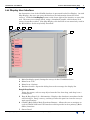
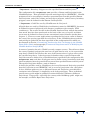
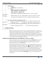
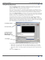
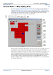
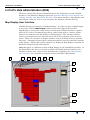
Main database field display panel. Select the 'tab' to display each of the useradministered tables.
2
Menu Item: File
3
Menu Item: Options
4
Database button. Opens the dialog box used to manage the display list
5
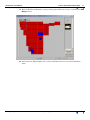
Region Outline (is not a Drag & Drop Panel—instead, click inside this panel).
Opens the Region Outline Import Tool. This is an important database
administrative tool, used in the initial setting up of map sheet tables of a GDADS
database. Allows the GDADS data administrator to import an Arc shape file
containing all of the map sheets for a given 'region' layer (for example, the 1:250k
series). See "Adding Multiple Map Sheets" for details.
6
GDADS (Back-Office) Main Functions Buttons. Allows the user to navigate to
each of GDADS' different GUI interfaces which provide its four primary (BackOffice) functions.
7
Status Panel.
Adding a New Survey
There are three components to data stored in GDADS:
•
Survey data—stored in a directory on the system's hard disk
•
Survey description—specifications describing the survey, stored in the database
•
Survey location—a survey boundary polygon, also stored in the database
These three components are linked together by a unique identifier, the surveyname.
Thus every survey must first be assigned a unique survey name. A surveyname
directory is created in GDADS ONLINE storage area, and all survey files are written
into that directory. A new record is added to GDADS database, containing brief
survey specifications for surveyname. A survey boundary polygon for surveyname
is also added to the database. Surveyname is the key which GDADS uses to link the
survey information and the location (boundary polygon) to actual data.
Checklist
Library | Help | Top
1
Collate the survey data and its documentation
2
QC. Check data quality, completeness and detail of documentation (Store quality
data)
3
Generate grids of all required 'for sale' products (** see note below—MUST be
'projected' grids)
4
GridMerge. Incorporate grids into country-wide (GridMerge) grid datasets (**
see note below)
5
Store the data in directory surveyname, with 'for sale' products organised within
subdirectories.
6
Generate a survey boundary polygon, in the specified Datum and Projection (* see
note below)
7
Add the surveyname records to the metadata and boundary polygon tables of the
GDADS database
8
Archive data
9
If non-confidential, copy data to the Front-Office computer system (for customeruser access)
© 2006 Intrepid Geophysics
| Back |