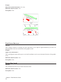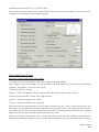
1
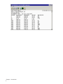
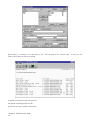
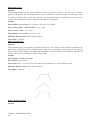
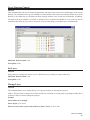
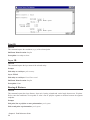
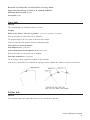
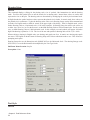
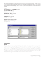
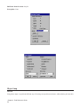
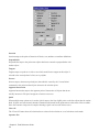
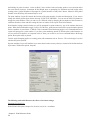
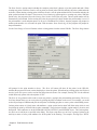
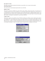
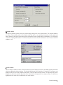
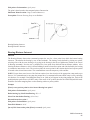
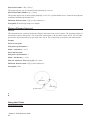
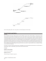
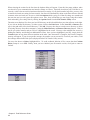
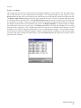
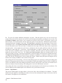
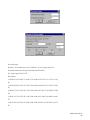
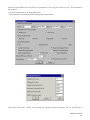
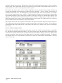
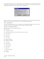
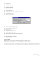
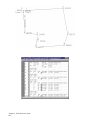
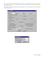
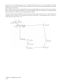
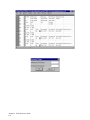
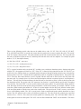
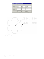
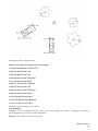
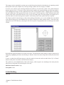
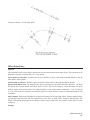
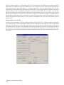
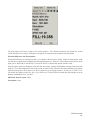
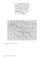
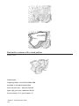
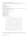
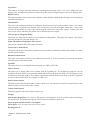
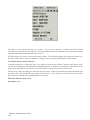
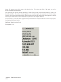
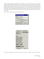
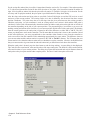
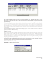
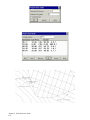
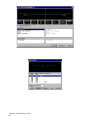
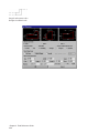
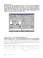
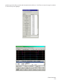
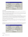
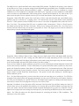
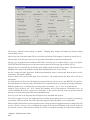
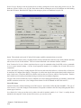
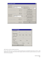
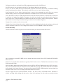
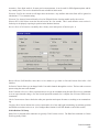
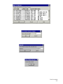
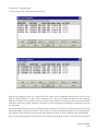
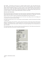
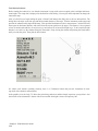
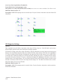
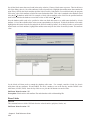
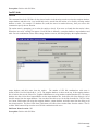
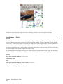
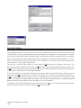
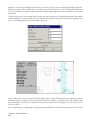
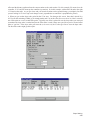
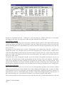
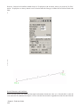
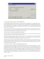
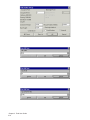
Point number (R-RadiusPt,U-Undo,Enter to end): pick a point
Point number (R-RadiusPt,U-Undo,Enter to end): R for radius
Radius point number or pick point: pick a point
Curve direction (Left/<Right>)? Press Enter
End of Arc point number (U-Undo,Enter to end): pick a point
Point number (R-RadiusPt,U-Undo,Enter to end): pick a point
Inverse with Area
PNTNO BEARING DISTANCE NORTHING EASTING STATION
PP 5039.0449 4884.7516 0.0000
N 72d28'12'' E 102.5847
PP 5069.9438 4982.5722 102.5847
CHORD BEARING: S 62d41'50'' E
RADIUS: 67.7503 CHORD: 95.5331 DEGREE: 85d
LENGTH: 106.0261 DELTA: 89d39'55'' TANGENT: 67.3556
PP 5026.1236 5067.4625 208.6107
S 17d51'53'' E 32.1815
PP 4995.4937 5077.3348 240.7923
S 77d32'11'' W 173.0496
PP 4958.1461 4908.3635 413.8418
N 16d16'15'' W 84.2742
PP 5039.0449 4884.7516 498.1161
Closure Error Distance> 0.0000
Total Distance Inversed> 498.12
AREA: 14761.5406 SQ FT OR 0.3389 ACRES
Point number (R-RadiusPt,U-Undo,Enter to end): pick a point
Point number (R-RadiusPt,U-Undo,Enter to end): pick a point
Point number (R-RadiusPt,U-Undo,Enter to end): Press Enter
SQ. FEET: 27247.4 SQ. YARDS: 3027.5 SQ. MILES: 0.0
ACRES: 0.63 PERIMETER: 668.35
Pick area label centering point: pick a point
Erase Polyline Yes/No <Yes>: Press Enter The command plots a polyline that represents the figure you defined if
you want to keep the polyline respond with No.
Pull-Down Menu Location: Cogo
Keyboard Command: IA
Prerequisite: None
Chapter 2. Field Reference Guide
136