1
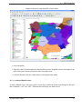
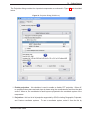
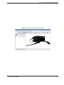
1. Forward
Welcome to the wonderful world of Geographical Information Systems (GIS)! Quantum GIS (QGIS)
is an Open Source Geographic Information System. The project was born in May of 2002 and was
established as a project on SourceForge in June of the same year. We’ve worked hard to make
GIS software (which is traditionaly expensive commerical software) a viable prospect for anyone with
basic access to a Personal Computer. QGIS currently runs on most Unix platforms, Windows, and
OS X. QGIS is developed using the Qt toolkit (http://www.trolltech.com) and C++. This means
that QGIS feels snappy to use and has a pleasing, easy to use graphical user interface.
QGIS aims to be an easy to use GIS, providing common functions and features. The initial goal was
to provide a GIS data viewer. QGIS has reached that point in its evolution and is being used by many
for their daily GIS data viewing needs. QGIS supports a number of raster and vector data formats,
with new support easily added using the plugin architecture (see Appendix A for a full list of currenly
supported data formats). QGIS is released under the GNU Public License (GPL). Developing QGIS
under this license means that you can inspect and modify the source code and guarantees that you,
our happy user will always have access to a GIS program that is free of cost and can be freely
modified. You should have received a full copy of the license with your copy of QGIS, and is also
available as Appendix B.
Note: The latest version of this document can always be found at
http://qgis.org/docs/userguide.pdf
1.1. Major Features
QGIS has many common GIS features and functions. The major features are listed below.
1. Support for spatially enabled PostgreSQL tables using PostGIS
2. Support for ESRI shapefiles and other vector formats support by the OGR library, including
MapInfo files
3. GRASS integration, including view, edit, and analysis
4. On the fly projection of vector layers
5. Map composer
6. Identify features
7. Display attribute table
8. Select features
QGIS 0.8 User Guide
1