1
4.7 Reclass Raster
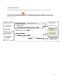
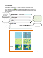
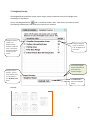
The Reclass tool allows the user to reclassify or change input cell values to alternative values.
tool on the Analysis toolbar. Note: Input for this tool must be
Click on the Raster Calculator
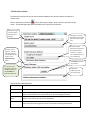
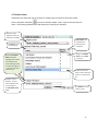
raster. The following window opens and allows you to specify your selection.
Specify the raster
target layer which you
would like to reclassify
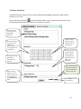
The Value you will
be reclassifying.
This example Reclass
Raster reclassifies
Tug/Barge and Tanker 4,
and reclassifies Gov
vessel, Passenger vessel,
and Govt vessel (Nor) to
2. General Cargo Ship is
reclassed to 0.
Specify an output
filename. The new
raster data layer with
your will appear in
your My Data (raster)
folder.
Reclass Value must
be between 0-5.
Reclass value 0 =
transparent
Assign a new Reclass
Value for each Value
in the layer.
Double click the ‘0’ to
assign a new reclass value.
Type in a new value from
0-5.
Click Submit to convert
vector to raster.
17