1
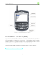
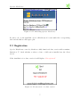
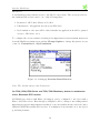
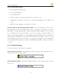
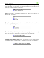
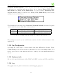
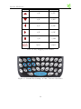
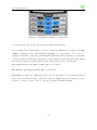
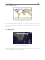
Skylab Mobilesystems Ltd.
http://www.skylab-mobilesystems.com
Spot for Blackberry
User Manual
Skylab’s positioning and orientation tool
Version 1.4.1
Contents
1 Introduction
3
2 Installation
2.1 Devices . . . . . . . . . . . . . . . . . . . . . . . . . . . . . . . . . . . .
2.2 Installation - over the air (OTA) . . . . . . . . . . . . . . . . . . . . . . .
2.3 Registration . . . . . . . . . . . . . . . . . . . . . . . . . . . . . . . . . .
4
4
5
6
3 Using Spot
3.1 Settings . . . . . . . . . . . . .
3.1.1 Launching . . . . . . . .
3.1.2 Location Provider . . . .
3.1.3 Global Settings . . . . .
3.1.4 Key Configuration . . .
3.1.5 Hardware Info . . . . . .
3.1.6 Log . . . . . . . . . . . .
3.2 Position Info . . . . . . . . . . .
3.3 Map . . . . . . . . . . . . . . .
3.3.1 Navigation in Map View
3.3.2 The Layer Manager . . .
3.3.3 Web Map Service . . . .
3.3.4 Waypoints Layer . . . .
3.3.5 Tracklog Layer . . . . .
3.3.6 Worldmap Layer . . . .
3.4 Waypoints . . . . . . . . . . . .
3.4.1 Add Waypoint . . . . .
3.4.2 Browse Waypoints . . .
.
.
.
.
.
.
.
.
.
.
.
.
.
.
.
.
.
.
.
.
.
.
.
.
.
.
.
.
.
.
.
.
.
.
.
.
2
.
.
.
.
.
.
.
.
.
.
.
.
.
.
.
.
.
.
.
.
.
.
.
.
.
.
.
.
.
.
.
.
.
.
.
.
.
.
.
.
.
.
.
.
.
.
.
.
.
.
.
.
.
.
.
.
.
.
.
.
.
.
.
.
.
.
.
.
.
.
.
.
.
.
.
.
.
.
.
.
.
.
.
.
.
.
.
.
.
.
.
.
.
.
.
.
.
.
.
.
.
.
.
.
.
.
.
.
.
.
.
.
.
.
.
.
.
.
.
.
.
.
.
.
.
.
.
.
.
.
.
.
.
.
.
.
.
.
.
.
.
.
.
.
.
.
.
.
.
.
.
.
.
.
.
.
.
.
.
.
.
.
.
.
.
.
.
.
.
.
.
.
.
.
.
.
.
.
.
.
.
.
.
.
.
.
.
.
.
.
.
.
.
.
.
.
.
.
.
.
.
.
.
.
.
.
.
.
.
.
.
.
.
.
.
.
.
.
.
.
.
.
.
.
.
.
.
.
.
.
.
.
.
.
.
.
.
.
.
.
.
.
.
.
.
.
.
.
.
.
.
.
.
.
.
.
.
.
.
.
.
.
.
.
.
.
.
.
.
.
.
.
.
.
.
.
.
.
.
.
.
.
.
.
.
.
.
.
.
.
.
.
.
.
.
.
.
.
.
.
.
.
.
.
.
.
.
.
.
.
.
.
.
.
.
.
.
.
.
.
.
.
.
.
.
.
.
.
.
.
.
.
.
.
.
.
.
.
.
.
.
.
.
.
.
.
.
.
.
.
.
.
.
.
.
.
.
.
.
.
.
.
.
.
.
.
.
.
.
.
.
.
.
.
.
.
.
.
8
8
8
8
10
12
12
12
13
13
14
17
17
18
18
19
19
20
20
Spot for Blackberry
3.5
3.6
3.4.3 Manage Categories . . . . . . . . . . .
3.4.4 Get Geocaching Details for Waypoints
3.4.5 Waypoint Import and Export . . . . .
Elevation . . . . . . . . . . . . . . . . . . . .
Satellites . . . . . . . . . . . . . . . . . . . . .
.
.
.
.
.
.
.
.
.
.
.
.
.
.
.
.
.
.
.
.
.
.
.
.
.
.
.
.
.
.
.
.
.
.
.
.
.
.
.
.
.
.
.
.
.
.
.
.
.
.
.
.
.
.
.
.
.
.
.
.
.
.
.
.
.
.
.
.
.
.
.
.
.
.
.
22
22
22
23
23
4 Troubleshooting
24
4.1 FAQ . . . . . . . . . . . . . . . . . . . . . . . . . . . . . . . . . . . . . . 24
4.2 Costumer Support . . . . . . . . . . . . . . . . . . . . . . . . . . . . . . 25
5 Warranty
5.1 License . . . . . . . . . . . . . . . .
5.2 WMS Usage . . . . . . . . . . . . .
5.3 Using Spot while Driving a Vehicle
5.4 Third Party Announcements . . . .
3
.
.
.
.
.
.
.
.
.
.
.
.
.
.
.
.
.
.
.
.
.
.
.
.
.
.
.
.
.
.
.
.
.
.
.
.
.
.
.
.
.
.
.
.
.
.
.
.
.
.
.
.
.
.
.
.
.
.
.
.
.
.
.
.
.
.
.
.
.
.
.
.
.
.
.
.
.
.
.
.
.
.
.
.
26
26
26
26
26
1 Introduction
Spot combines the power of GPS with worldwide maps and a flexible waypoint management. Orientation and routing enables you to find interesting places, store and share
them with others.
Spot’s features:
• Positioning information: GPS status, coordinates, height, speed, heading, signal
strength and current time
• Maps: Integrated world map, map download from the Internet or import of your
own maps, simultaneously display waypoint and map layers
• Waypoint management: Add, edit, categorize, import and export waypoints
• Satellites: Get the position information of satellites in view (only available when
using Bluetooth GPS)
• Elevation: Elevation graph of your track
Spot contains plenty of features for freetime and professional users. Using modern Java
technology allows us to offer Spot for many more platforms than just the Blackberry.
It is able to run on nearly any Java-enabled mobile device. Most of the current mobile
phones and PDAs (running PalmOS or Windows) are compatible to the normal Spot
version. You are not limited to the Blackberry platform (please note: the non-Blackberry
version does not run on Blackberriy devices and vice versa). The custom WMS server
feature allows to integrate Spot into an existing (OGC WMS compatible) company
GIS (Geographic Information System) plus the usage of free accessable WMS servers
on the Internet. Furthermore there are some features like field navigation, statistics
(track elevation, tracklog, etc.), waypoint/POI/landmark management, full screen maps,
satellite maps, moving map navigation and others.
4
2 Installation
2.1 Devices
This version of Spot for Blackberry runs on Blackberry 7520 and 7100i using its built-in
GPS receiver.
Using Spot for Blackberry on other Blackberry devices (e.g. 7100, 8700 Series and 7250,
7290) requires an external Bluetooth GPS receiver.
5
Spot for Blackberry
Figure 2.1: General Blackberry Controls
2.2 Installation - over the air (OTA)
Spot can be downloaded OTA via Internet to the device and installed directly. This is
the easiest method to install Spot on your device. The Blackberry needs a working
Internet connection. You can use the WAP browser or the Blackberry browser to access
Skylab Mobilesystems’ OTA Download Center and install it directly.
The OTA download link for the most recent demo version of Spot is located at:
http://micro.skylab-mobilesystems.com/
6
Spot for Blackberry
Figure 2.2: Downloading Spot for Blackberry
Be sure to choose the right link. Spot for Blackberry is located under the corresponding
title and the link is called spot.jad.
2.3 Registration
Spot for Blackberry comes by default as a fully functional demo version with a runtime
limitation. To check whether you have a demo or full version installed use the About
screen.
If the installation is a demo version it will display: Not registered!
Figure 2.3: About screen of a demo version
7
Spot for Blackberry
If it is a registered version it will show: Registered to: YOUR NAME
Figure 2.4: About screen with registration information
To register your demo version of Spot for Blackberry click Register Spot for Blackberry
in the main menu and enter your name and serial number you have received from Skylab
Mobilesystems or one of our distributors.
Handango: Please enter your RIM Esn / PIN in the name field and the license key
in the serial field.
Share-it: Please enter your registration name in the name field and the license key
in the serial field.
8
3 Using Spot
3.1 Settings
3.1.1 Launching
To launch Spot for Blackberry on your Blackberry highlight the green Spot icon on the
Blackberry home screen and press the Trackwheel.
Figure 3.1: The Spot
3.1.2 Location Provider
The Location Provider is an important part of Spot. This component provides the
positioning function for all position based features. A location provider must be activated
for the positioning support to work.
On Blackberry 7520 and 7100i
The Blackberry has a nicely implemented integrated GPS module. Spot for Blackberry
activates the associated location provider automatically and does not need any user
9
Spot for Blackberry
interaction.
Your Blackberry may restrict access to the GPS location data. The access provided to
the built-in GPS receiver can be one of the following three:
1. Restricted - GPS data delivery is blocked
2. Unrestricted - all applications can access GPS data
3. By Permission - the user will be asked whether an application should be granted
access to GPS data or not
To configure the access restriction setting select Options➝Location Based Services
from the Blackberry main screen and use Change Option to change the privacy access
control to Unrestricted or By Permission.
Figure 3.2: Setting up Location Based Services
Note: The default setting is By Permission.
On 7100, 8100, 8700 Series and 7250, 7290 Blackberry devices in combination
with a Bluetooth GPS receiver
All Blackberry devices with Bluetooth support can be configured to use Spot with a
Bluetooth GPS receiver. Even though you might be able to change some settings under
Options➝Location Based Services that does not necessarily mean your device has a
built-in NAVSTAR satellite GPS receiver. You might need an external one to use Spot’s
positioning features.
10
Spot for Blackberry
Pair two Bluetooth devices
1. Select Options➝Bluetooth
2. Press the Trackwheel
3. Select Add Device
4. Select the name of the appropriate device you want to use
5. Authenticate yourself to the device by entering the passkey for the Bluetooth
device
6. Enter the same passkey on the Bluetooth device
Connect Spot to your Bluetooth GPS receiver Spot automatically connects to the
first Serial Port Profile (SPP Slave) device on startup. On startup you will be
informed by a popup whether the connection was successful. Usually you do not need
to do anything else for the positioning to work. If you want to change the Bluetooth
GPS receiver during runtime go to Settings➝Bluetooth GPS, press the Trackwheel
and select Stop BT GPS. Now select the device in the list you want to connect to, press
the Trackwheel again and choose Select. A connection information screen will appear
showing whether the connection could be established successfully or any error has been
occurred.
3.1.3 Global Settings
You can modify the following global settings:
Center Map to Location Automatically centers the map to the current position as
reported by your location provider.
Show Position on Map Shows the latitude/longitude of the current position on the
map screen.
11
Spot for Blackberry
Power Saving Mode Activating this option will lessen Spot’s usage of the positioning
device and should decrease battery drain. As a disadvantage positioning information
will be less accurate and updates will be slower.
Units You can choose between metric and imperial (also known as US customary or
English) unit representation.
Time You can choose between local time and General Mean Time / Universal Time
Coordinated (GMT/UTC) display.
Draw Text Background If this option is enabled text outputs (position, button action)
in the map view will be painted on a solid background for better readability.
Check on Startup for New Version If this option is enabled Spot for Blackberry will
automatically check on startup whether you are using the latest version (recommended).
12
Spot for Blackberry
Overwrite Network Defaults If this option is enabled the default network settings of
your device are overridden and you are able to choose between Direct TCP (NonBES-Mode) and Proxy TCP (BES-Mode). If you are using a Blackberry Enterprise Server (BES) you should select Proxy TCP (BES-Mode) if the default
setting does not work for you.
The default network setting when Overwrite Network Defaults is disabled depends
on the network you are using. Here is an overview:
Network Default network setting
Alternate network setting
GSM
Proxy TCP (Non-BES-Mode) Direct TCP (BES-Mode)
iDEN
Direct TCP (BES-Mode)
Proxy TCP (Non-BES-Mode)
Table 3.1: Default network settings according to the network
The settings are saved on your mobile device and are reloaded on the next start of the
application.
3.1.4 Key Configuration
Spot supports a wide range of devices which often have different key layouts. If the
default binding does not work or is not comfortable for you, you can change it here. You
have to press a key for each function and select ”next key” from the menu until all keys
are set.
3.1.5 Hardware Info
Shows device specific information like CLDC and MIDP versions and JSR capabilities.
3.1.6 Log
The application’s log file for information and debugging purposes.
13
Spot for Blackberry
3.2 Position Info
The Position Info screen shows the current position according to your location provider,
e.g. your GPS receiver. Apart from the GPS status indicator it displays longitude and
latitude in decimal degrees, height, speed and time information. A typical Position Info
screen looks like this:
Figure 3.3: Position information
3.3 Map
The Map view shows your current position on data layers.
Spot supports the following data layers:
• OGC Web Map Services (WMS)
• Waypoints / Points Of Interest
• Tracklog
• Worldmap
14
Spot for Blackberry
3.3.1 Navigation in Map View
Figure 3.4: Items on the map
You can navigate in the map view by pressing the corresponding keys to zoom and pan
or let the location provider automatically pan to the current position. The default key
layout for navigation in the map depends on the device you are using:
UP: used for panning north and zooming in
DOWN: Used for panning south and zooming out
LEFT: Used for panning west
RIGHT: Used for panning east
SWITCH: Used for switching between pan and zoom mode
ZOOM FACTOR: Used to change the zoom factor (2x, 4x, 8x)
15
Spot for Blackberry
Action
7200, 7500, 8700 series
7100 series
2/E
2/TY
8/X
8/BN
4/S
4/DF
6/F
6/JK
5/D
5/GH
Space
0/Space
Table 3.2: Key mapping device matrix
Figure 3.5: Default Key Settings on 7200, 7500 and 8700 Series
16
Spot for Blackberry
Figure 3.6: Default Key Settings on 7100 Series
You can set up your own key layout in Settings➝Key Config
If you activate the ”center map to location” feature the pan-mode is replaced by auto
center. Panning is done automatically depending on your position. To avoid a too
frequent recentering of the map, which might result in new Web Map Service requests if
you have enabled a WMS layer, the map is only recentered if the current position differs
more than 20 pixels from the display center. This feature can be set through:
Settings➝Global Settings➝center map to location
or
Map➝Global Settings➝center map to location.
In zoom mode there are 3 different zoom levels: 2x, 4x and 8x. You can switch between
the zoom levels with the 1-key or the key you have configured in your settings. It is also
possible to select ”zoom in” and ”zoom out” from the Trackwheel menu.
17
Spot for Blackberry
3.3.2 The Layer Manager
Figure 3.7: Layer manager screen
To add new layers or to toggle the visibility of layers use the ”Layer manager” in the
menu. The Layer manager shows a list of all currently loaded layers and their visibility
setting which can either be visible (checkbox is checked) or invisible (checkbox is not
checked).
Scale info is a special layer which shows the current scale in the lower left corner of the
map.
3.3.3 Web Map Service
Figure 3.8: WMS Layer Options
18
Spot for Blackberry
Due to compliance to the OGC (Open GIS Consortium) WMS standard you can access a huge amount of free Web Map Services which provide you with topographic,
aerial and street maps directly to your Blackberry device. Your are not bound to
a subscription based service or restricted to use a specific proprietary map service.
Skylab Mobilesystems hosts a list of public accessible WMS services at http://www.
skylab-mobilesystems.com/en/wms serverlist.html. Each WMS usually allows you to
select multiple layers which are rendered into one image by the server. Spot has integrated some example WMS URLs. To change the default WMS select: LayerManager➝Web
Map Service➝Options. You can use a custom WMS by entering the Capabilities URL.
3.3.4 Waypoints Layer
The waypoint layer shows all saved waypoints on the map. Each waypoint is visualized
with the corresponding waypoint category icon or a red rectangle if no icon has been
selected. All waypoints are labeled with their name if it fits on the map screen without
colliding with other labels. If you can’t see the labeling, it is most likely that there
are several waypoints clustered together. Zoom in to reduce the amount of visualized
waypoints.
3.3.5 Tracklog Layer
Figure 3.9: A sample tracklog layer
The tracklog layer visualizes your track on the map.
19
Spot for Blackberry
3.3.6 Worldmap Layer
Figure 3.10: The default worldmap layer
The worldmap layer displays a rough map of the world for a quick orientation. If you
need a more detailed map you might want to add a Web Map Service layer or a map
image layer.
3.4 Waypoints
Figure 3.11: A sample waypoint layer
The waypoint menu allows you to manage your waypoints. You can add, browse, import
and export waypoints or use the routing feature.
20
Spot for Blackberry
3.4.1 Add Waypoint
This option allows you to create a new waypoint. If the location provider delivers a
position, the latitude, longitude, and height field will be pre-filled with data from the
current position. You can change them if you like to. If no position is available the fields
default to ”0”. The following information can be entered:
• X: the longitude in decimal degrees
• Y: the latitude in decimal degrees
• Z: the elevation in meters or in feet (go to Settings➝Global Settings➝Units
to change the unit settings)
• Category: select on of the preconfigured or your own categories to sort your waypoints
• Name: a short name for the waypoint, limited to 20 characters
• Description: description of or additional information for the waypoint, limited to
200 characters
3.4.2 Browse Waypoints
Figure 3.12: Browse Waypoints screen
21
Spot for Blackberry
You can browse through all waypoints stored on your device. Each waypoint is displayed
in the list with the waypoint name and its corresponding category symbol. You can perform the following operations on the selected waypoint: Edit, Delete, (show) Details.
Details: Shows all available information for the selected waypoint.
Edit: You can edit all fields of the waypoint like in Waypoints➝add Waypoint.
Delete: Deletes the selected waypoint.
Route To: Route to an existing waypoint from your current location. To allow the
routing to a waypoint, select one in the list and activate the routing screen by pressing
select. If you have not created or imported waypoints before, the list will be empty.
The routing screen will show you a blue arrow that tells the direction you should go
towards your target destination. Furthermore it shows information like the waypoint’s
name, your current speed, the estimated time of arrival (ETA) and the estimated time
en-route (ETE). The circle around the direction arrow is a compass. The red line of the
circle shows the north direction based on the GPS heading.
Figure 3.13: Going to Joey
Note: If you are not moving some GPS receivers will report a speed of 0 km/h or mph
and a heading of 0 degrees. This will a show a direction heading north. Furthermore
ETA and ETE cannot be calculated if you are not moving.
22
Spot for Blackberry
3.4.3 Manage Categories
You can manage your waypoint categories here. Each waypoint belongs to one category.
If no category is specified, the waypoint is assocciated with the default category. You
can add, rename or delete a category, or change its icon.
Add: Creates a new waypoint category.
Select Icon: Chooses an icon for the category. This allows you to quickly identify the
category of a waypoint on the map.
Rename: Renames an existing category.
Delete: Deletes the selected category. If the category contains waypoints, you can
choose to move them to the default category or delete them as well.
3.4.4 Get Geocaching Details for Waypoints
Spot has extensive built-in geocaching support. For geocaches from http://www.geocaching.
com the cache description can be downloaded on the fly. After downloading the cache
description it will be added to the waypoint description. Use Waypoints➝Browse
Waypoints➝Details➝Get cache description to download it.
3.4.5 Waypoint Import and Export
You can import waypoints in the popular waypoint formats GPX and LOC. Details
on other applications supporting GPX and sites with GPX waypoints can be found at
http://www.topografix.com/gpx.asp.
To import waypoints from a website select Waypoints➝GPX import (web) or select
Waypoints➝LOC import (web). The waypoints will be downloaded to your device and
integrated into the Spot waypoint database. The waypoints will be stored in a new
category named after the download URL.
Note: These options only appear if JSR-75 is supported.
23
Spot for Blackberry
3.5 Elevation
The elevation screen shows the track elevation from the currently recorded tracklog (the
tracklog itself can be made visible in the map view). There are two labels in this screen
to show the relation of the elevation. The top label indicates the highest elevation the
user has reached during the current track. The lower label indicates the average elevation of the track. The bottom represents the lowest altitude the user has been on
during track recording. A common Elevation screen may look like in the following image:
Figure 3.14: Tracklog Elevation Visualization
3.6 Satellites
Note: This screen is only available on devices which do NOT have a built-in GPS receiver and are used with an external Bluetooth GPS receiver!
The satellite screen is a passive component. It shows the current positions of satellites
in view and their signal strength. The closer a displayed satellite is to the outer circle
the closer is the satellite’s position to the horizon. The closer it is shown to the center
of the circle the more it is moving to the zenith above you. The inner circle symbolizes
positions in an angle of 45° between the horizon and the zenith. The bars show you the
signal strength of a single satellite.
24
4 Troubleshooting
4.1 FAQ
Why do I get the error message ”net rim locationapi not found” on my
Blackberry 7520?
Some old versions of the Blackberry 7520 do not have the location API installed by
default. A software update on your Blackberry will add it. Use the following link to
download and update your Blackberry software:
https://www.blackberry.com/SoftwareDownload/index.jsp?client=biTZdMddN
Where is the Satellite info view?
Spot has a view which provides additional information about the GPS satellites. We
removed this view from the Blackberry version of Spot, because the Blackberry does not
provide this information which makes the view useless.
I can’t install Spot with the Application Manager. What’s wrong?
Currently you have to install Spot via OTA. You can download Spot directly to your
device by using our OTA website in your Blackberry browser:
http://micro.skylab-mobilesystems.com
I get a map of the world, but I do not know where I am, what’s wrong?
The map screen shows the worldmap as default map if no GPS position has been received.
After the first GPS position is received, Spot will automatically zoom to your current
position.
25
Spot for Blackberry
I can’t see a map and got a ”WMS ERROR”, what’s wrong?
A WMS Error indicates a problem with the Mapping Service which is currently in use.
It might be a problem with your internet connection or a problem of the map server.
You can check the error details in Settings➝Log. If you cannot figure out what is
wrong please send us an e-mail with the error description.
Why does Spot drain the battery off that fast?
Earlier beta versions of Spot had a problem with power consumption on the Blackberry.
The current version should work much better. You can select a power saving mode
(Settings➝Global Settings➝Power saving mode) which will improve the battery
time but may result in slower/less accurate GPS positions.
Spot exits after some minutes. Why?
Spot is generally distributed as a demo version and will exit if the time limitation is
reached. In this case, a message will be shown that the time limitation of the demo
version is reached and Spot will exit. If you are not actively using Spot at that moment
you might miss this user information alert. However you can restart Spot again and if you
have received a serial key from Skylab Mobilesystems Ltd. or one of our distributors
you should enter it in Spot to enable the full version which does not have a runtime
limitation.
4.2 Costumer Support
Please send us an email with your questions or comments. We monitor all emails and
will promptly reply to your inquiries.
Email: [email protected]
26
5 Warranty
5.1 License
Copyright by Skylab Mobilesystems 2005, 2006, all rights reserved. Spot is subject to
the Skylab Mobilesystems Ltd. Software License Agreement which version is available
from http://www.skylab-mobilesystems.com/en/license.txt.
5.2 WMS Usage
The contained Web Map Server configuration for the map screen is an example configuration. There are no relations between Skylab Mobilesystems Ltd. and the respective
service providers. Furthermore this configuration shall only show how free accessable
WMS services can be used with Spot. They are NOT part of Spot.
5.3 Using Spot while Driving a Vehicle
Keep your eyes on the street! If you are using Spot in a vehicle while driving keep your
eyes on the street. It is commonly known that distracted drivers cause more accidents
than attentively ones. In some countries it is forbidden to use mobile devices while
driving.
5.4 Third Party Announcements
All rights of all announced trademarks, registered trademarks, products, images and
symbols belong to their corresponding company.
27