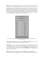
1
AN ADAPTIVE, AUTOMATIC PHASEPICKING AND EPICENTER LOCATING
PROGRAM BASED ON WAVEFORM CROSSCORRELATION
AND
ITS APPLICATION FOR PROCESSING
SEISMIC DATA IN NEW MEXICO
by
Wenzheng Yang
An independent study submitted in partial
fulfillment of the requirements for the
degree of
Master of Science in Geophysics
New Mexico Institute of Mining and
Technology
2004
Approved by ___________________________________________________
Chairperson of Supervisory Committee
__________________________________________________
__________________________________________________
__________________________________________________
-i-
Program Authorized
to Offer Degree _________________________________________________
Date
ABSTRACT
It is widely observed that seismic sources occurring very close to each other can share
very similar waveforms. Using this property, an adaptive, automatic phase-picking and
epicenter-locating program based on waveform cross-correlation has been developed and
applied to process daily seismic data of New Mexico. The core of this program is a reference
seismic event database, from which the phase and location information of a new event can
be inferred. With a sufficiently complete reference seismic dataset, this program should
produce robust initial seismic phase estimates while greatly improving the handling of false
triggers due to telemetry or other transient noise. These automatic results are designed to be
as precise as the manually processed results.
160 well-picked earthquakes and mining explosions in New Mexico during 1997-2003
were collected as an initial reference event set covering most of the historically active source
regions in the state. Each waveform in the reference event set has a high signal-to-noise ratio
and accurately-picked P and S phases. Two methods were developed to automatically
calculate waveform cross-correlation phase-picking and the location of epicenter.
The first, waveform-pair cross-correlation matching method correlates the most similar
waveform from the reference dataset to each waveform of a new event station by station and
-ii-
assigns the corresponding seismic phases to the new waveform according to crosscorrelation lag. Note that a new event may be correlated with different reference events at
different stations.
The second, event-pair cross-correlation matching method correlates the most similar event
from the reference dataset to the new event by stacking the cross-correlation curves of all
common station-waveform-pairs. The second method provides more robust results than the
first method.
Due to the concentration of seismic stations in the Socorro area, an “attracting” problem
developed when the event-pair cross-correlation matching method was applied to process seismic
data of New Mexico. This problem happened when the above method construed distant
events to be local ones, because seismic events occurring more than 200 km from Socorro
usually have weak S-phases and are therefore identified as seismic events from the Socorro
area by the event-pair cross-correlation matching method. To nullify this problem, the spectrogram
event-pair cross-correlation matching method was developed. This method matches event-pair in
the frequency domain, decreasing the effect of “attracting” phenomenon. This works
because within the frequency band of 6-10Hz, the energy of S-phase for local events is
prominent and the background noise energy is very small.
The computer program (PLRR) incorporating these methods has been developed under
Matseis/Matlab (developed at the Sandia National Laboratories) in the UNIX
environment. It is used to detect initial seismic phases and identify locations of local seismic
events in New Mexico from 2000 to 2004. Manual phase repicking and epicenter relocating
are applied to the results given by this program to produce a final, reviewed catalogue. If
there is a new, high signal-to-noise event that is incorrectly located by PLRR (as determined
-3-
by the review process), it will be added into the reference dataset. The accuracy of phasepicking and epicenter-locating thus improves as more data are processed.
-4-
ACKNOWLEDGMENTS
I have been very privileged to have undoubtedly the most intuitive, smart and supportive
research and academic advisor anyone could ask for: Dr. Richard C. Aster. I have been
stimulated and excited by his constant flow of good ideas. I will always admire Rick’s to cut
through reams of algebra with a single visual explanation. In addition, he has taught me a
great deal of new computer skill. Last but certainly not least, he has always known how to
give me a little push forward whenever I needed it.
My most intense collaboration has been with Darren Hart. Darren gave me lots of help
and ideas in my quest to understand Matseis and develop PLRR. I cannot remember how
many weekends we spent working together in MSEC 345. Darren also proofread this
independent study very carefully and provided many valuable suggestions.
Dr. Allan Sanford and Dr. John Schlue gave me valuable instruction on how to pick
seismic phases, especially the reflected phases off the Socorro magma body. My discussions
with them never failed to ignite my interest in using similar waveforms to study crustal
structure above the mid-crustal magma body.
The graduate students of the New Mexico Tech Geophysics Department (both past and
present) comprise such a superb research group. The opportunity to bounce ideas off so
many excellent minds has been priceless. The upcoming Dr. Daniel Bowman helped me
process seismic events in New Mexico in the last month of this project and proofread this
independent study work.
My fascination with the physical world is undoubtedly due to the influence of my
parents. When I was a young child, they often brought me books about famous scientists
and the natural world. These stories had a lasting impression on me. The accumulation of
-5-
knowledge and inspiration I inherited from them has greatly contributed to my current
fascination with earth science research.
This work has resulted from a project supported in part by the Defense Threat Reduction
Agency and Air Force Research Laboratory (contract number DTRA01-01-C-0085), US
Department of Defense; the content does not necessarily reflect the position or the policy of
the US Government, and no official endorsement should be inferred. Substantial components
of the New Mexico Tech Earthworm system were funded by the US Geological Survey.
-6-
TABLE OF CONTENTS
Abstract……………………………………………………………………………………(1)
Acknowledgements………………………………………………………………………...(3)
Table of Contents………………………………………………………………………….(5)
Chapter 1. Introduction
Background Seismicity in New Mexico………….……………….....(7)
The SC seismic Network and nearby Seismic Stations…..…………(10)
Major Seismic Source Regions in New Mexico……………………(13)
Characteristic Waveform Patterns in different source regions……..(17)
Pervious research……………………………….………………...(20)
Chapter 2. Waveform cross-correlation technique
Waveform Cross-correlation……………………………………..(23)
Cross-correlation coefficient Matrix…………….………………...(26)
Chapter 3. The development of PLRR
MatSeis…………………………………………………………..(29)
PLRR……………………………………………………………(30)
Data Format conversion…………………………………………(31)
Reference dataset……………………………………………........(33)
Strategy of phase detection and epicenter location………………..(35)
Waveform-pair cross-correlation matching……………………….(36)
Event-pair cross-correlation matching……………………………(37)
Spectrogram event-pair cross-correlation matching……..………...(39)
Ground data test…………………………………………………(41)
-7-
Chapter 4. Earthquake location in New Mexico (1997~2004)
Epicenter distribution of seismic events in New Mexico (1997-2004).....
……………………………………………………..(46)
Chapter 5. Summary, Suggestion and Conclusions
Summary…………………………………………………………(62)
Suggestions……………………………………………………….(63)
Conclusions………………………………………………………(64)
References
(66)
Appendix I: THE USER’S MANUAL OF PLRR
Appendix II: PLRR source code list and related codes in automatically
processing of the SC Earthworm system seismic data
-8-
Chapter 1
INTRODUCTION
Background Seismicity in New Mexico
Due to its long distance from major tectonic plate boundaries and weakness of internal
tectonic activity, the seismicity in the state of New Mexico is relatively quiet compared to
very active seismically regions such as California (Figure 1-1). However, historic activity
shows a moderate level of earthquake activity.
Figure 1-1. Relative seismicity ratez of New Mexico as compared to some earthquake-prone and seismically quiet regions [1].
Figure 1-2. Earthquake epicenter distribution in New Mexico and surrounding regions (1962-1995), using the data from [3].
Dashed line outlines the boundary of the state of New Mexico.
-9-
Figure 1-3(a,b). b value in for New Mexico regional seismicity and New Mexico seismicity associated to the Socorro Seismic
Anomaly (SSA ) (1962-1995, data from [3]).
Figure 1-2 illustrates the seismicity of natural earthquakes in New Mexico and bordering
regions from 1962 to 1995. Most of them were recorded by the Socorro seismic network of
New Mexico Tech (NMSN) [3], but some of the earthquakes that occurred in the 1970s
were recorded by the Los Alamos Laboratory, the University of Texas at El Paso and the
USGS. From Figure 1-2, we observe that the NMSN has documented numerous
earthquakes with duration magnitude (Md) above 2.0 inside the state of New Mexico.
However, the NMSN may not be sensitive enough to detect all earthquakes during this time
with less than 2.0 Md, occurring in the NE, NW, and SW corners of New Mexico, hence the
incomplete seismic record in those regions. According to the historical earthquake catalog
([3]), only 8 % of all 2000 earthquakes that occurred in New Mexico from 1962 to 1995 were
larger than 3.0 Md. Most earthquakes occurring in New Mexico are small events. Their Md
typically falls within the range of 1.3 to 2.5, and they are usually located in isolated source
regions. The magnitude-frequency curve is usually used to check the completeness of
earthquake catalogue, and the slope of this curve (b value) usually ranges from 0.6 to 1.3
-10-
around the world. However, as shown in Figure 1-3a, for New Mexico and bordering
regions, the b value of earthquakes was 0.76 and the fitting residuals were large. The best-fit
line departs from the data around Md 1.5, which tells us that earthquakes with a magnitude
less than 1.5 are incomplete in [3]. Figure 1-3b shows that the b value of the Socorro
Seismic Anomaly (SSA) is 0.77. The fitting residuals were very small, which means the
catalog of [3] is complete for SSA region down to approximately Md 1.0.
The SC seismic Network and nearby Seismic Stations
Figure 1-4. Seismic stations around New Mexico. The green area is the Socorro Seismic Anomaly (SSA), the red points are
seismic stations, and the cyan diamonds are major mines.
-11-
Table 1-1. Seismic Station list (1997-March, 2004)
Station
BAR
BMT
CAR
CBET
CL2B
CL7
CPRX
GDL2
HTMS
LAZ
LEM
LPM
MLM
SBY
SMC
SSS
WTX
ANMO
SDCO
WMOK
TUC
ISCO
WUAZ
LTX
CBKS
DAG
Network
SC
SC
SC
SC
SC
SC
SC
SC
SC
SC
SC
SC
SC
SC
SC
SC
SC
IU
US
US
US
US
US
US
US
SC
Component
ZEHZ
ZEHZ
ZEHZ
ZEHZ
ZEHZ
ZEHZ
ZEHZ
ZEHZ
ZEHZ
ZEHZ
ZEH(Z,N,E)
ZEHZ
ZEHZ
ZEHZ
ZEHZ
ZEHZ
ZEHZ
ZBHZ
ZBHZ
ZBHZ
ZBHZ
ZBHZ
ZBHZ
ZBHZ
ZBHZ
ZEHZ
Latitude
34.150
34.275
33.953
32.421
32.264
32.413
33.031
32.200
32.473
34.402
34.166
34.312
34.814
33.975
33.779
32.355
34.072
34.946
37.746
34.738
32.310
39.800
35.517
29.334
38.814
32.591
Longitude
-106.628
-107.260
-106.735
-103.990
-103.879
-103.807
-103.867
-104.364
-103.634
-107.139
-106.974
-106.632
-107.145
-107.181
-107.019
-103.397
-106.946
-106.457
-105.501
-98.781
-110.784
-105.613
-111.374
-103.667
-99.737
-104.692
Altitude(m)
2121
1987
1658
1042
1045
1033
1356
1213
1192
1878
1698
1737
2088
3230
1560
1073
1555
1853
2569
486
906
2743
1592
1013
677
1396.7
(ps: After May, 2004, station HTMS was replaced by SRH)
Digitized data from 26 seismic stations in and outside New Mexico has been collected for
processing at the New Mexico Seismological Observatory since 1992. In 1999, the
Earthworm system was set up at NMSN to manage data flow and produce automatic
triggered waveforms files from automatic triggers. Since the beginning of 2003, the digitized
seismic data (i.e. waveform data) from the NMSC network has been archived at IRIRS-DMC
-12-
in Seattle. This was done so that researchers all over the world could download the data
from the IRIS-DMC website and to provide an independent long-term backup archive.
Out of the 26 seismic stations in the region, 18 of them are equipped with short period
seismometers maintained by the New Mexico Tech and are known as the SC (the associated
Federation of Digital Seismic Networks code) network. The SC network is concentrated in
two areas, Socorro area and Carlsbad. Ten seismic stations are located to study seismicity
associated to the SSA, and 8 seismic stations are set to monitor the seismicity localized
around the Waste Isolation Pilot Plant (WIPP) near Carlsbad. The sampling rates of these
short period seismometers are 100 samples per second (sps). Station LEM is the only threecomponent short period station used in this study.
There are 8 broadband seismic stations operated by other organizations around New
Mexico. All except ANMO (Albuquerque, New Mexico) are located outside of the state of
New Mexico. These stations compensate for the short coverage of the SC network in the
boundary area of New Mexico to some degree. All the broadband stations data used has a
sampling rate of 40 sps, except for TUC (Tucson), which is 20 sps.
NMSN uses the Earthworm v6.2 system (http://folkworm.ceri.memphis.edu/ew-doc/),
developed by the USGS, to digitize analog signals and store the continuous data for the last
seven days period on a local hard disk. IRIGE signal from GPS is used to time stamp the
digitized trace data. In Earthworm system, the module picker_ew picks the P-arrivals using
STA/LTA method, and the module binder_ew associates these P-arrivals with events. The
module trig2disk saves a user defined section of seismic data (usually 180 seconds) of to
-13-
disk as an event. Due to the existence of electric noise within the seismic signal transmission
system (i.e. signal telemetry from field-site location to the data-storage facility via phone line,
or microwave transmission), less than half of the triggered events generated by the trig2disk
module each month are real seismic events. Because this false-positive event detection rate,
we are looking into at a method to adaptively winnow out the noise events from the real
seismic events.
Major Seismic Source Regions in New Mexico
Although the northwestern area of the New Mexico is part of the Colorado Plateau, and the
Rio Grande rift bisects New Mexico down the middle, there is no obvious tectonic province
association connected with seismicity. Major seismic source regions in New Mexico are
relatively independent from each other.
One major source region is the Socorro Seismic Anomaly (SSA), which is located in the
central Rio Grande rift of New Mexico and overlies the Socorro Magma Body (SMB). The
SSA has been estimated to have an area of about 5,000 km2 ([4]) (green area in Figure 1-4).
Nearly 36% of the naturally occurring earthquakes occurring in New Mexico are
concentrated in this area, even though it covers only 1.6% of the total area of New Mexico
([4]). Some events occurring in the SSA region generate reflected P and S phases (PzP, SzP
and SzS phase arrivals) allowing researchers ([4]) to invert and to estimate the depth and
shape of the Socorro magma body and also to get more accurate estimations of event depth.
Seismic swarms and repeat earthquakes often occur inside the SSA, possibly being generated
by the injection of shallow magmatic materials into the crust at the depths above 12 km
-14-
([12]). The largest recent seismic swarms inside the SSA occurred during October 30 and
November 2, 2002, with about 246 micro-earthquakes recorded automatically by the
Earthworm real-time system. Most of them had obvious waveforms recorded at station
WTX (Figure 1-5).
Figure 1-5 WTX pseudo-helicorder plots show the SSA swarm during Oct 30 –Nov 2, 2002. Each line represents one event
The Raton area is another relatively active seismic region inside the New Mexico. In this
case the seismicity is possibly enhanced by mining and associated injection activity. There
have been several large earthquakes in the area between Raton and Trinidad Colorado in
recent years. In the period from August 28 to September 21, 2001, twelve earthquakes were
recorded by the USGS National Earthquake Information Center. The magnitude of the
largest event was Ml 4.6. Figure 1-6 shows three middle-size events that occurred in the
-15-
Raton area between June and August 2003. On March 22, 2004, another large earthquake
with a magnitude of 4.4 occurred in the Raton area.
Figure 1-6. Similar earthquakes that occurred in the Raton area
Teleseismic events with large magnitudes often trigger the Earthworm system and may thus
be initially improperly identified as local earthquakes. For this study of New Mexico
seismicity, we needed to filter out these events. The earth itself acts as a low pass filter since
teleseismic events have to travel much longer ray paths compared to local and regional
events.
It is therefore easy to differentiate teleseismic from regional seismic events by
comparing spectrograms or by applying a high-pass filter to the signals. The main energy of
teleseismic signal at short period stations is concentrated in 1~2 Hz band, whereas local and
regional seismic signals contain high frequency energy up to 10s of Hz (Figure 1-7).
-16-
Figure 1-7. Spectrograms of a local (upper) and a teleseismic event (bottom) recorded by WTX. The vertical axis is labeled by
normalized frequency (0 to 50 Hz).
Besides natural earthquakes, manmade seismic events (e.g., mining explosions) are often
recorded by the SC network. Four major regions where routine mining blasting occurs are
Morenci (southeastern corner of Arizona; cyan point in Figure 1-4), Tyrone (southwest corner
of New Mexico), Santa-Rita (to the east of Tyrone) and Mt. Taylor (to the northwest of
Albuquerque). Repeated earthquakes have often been observed around the station DAG since
2003, and they are likely induced seismic events ([2]).
Characteristic Waveform Patterns of different source regions
When waveforms from different source regions are recorded at a signal station, they show
different patterns or signatures due to differing Green’s functions associated with their
propagation paths. Generally, waveforms that come from the same source region share
similar characteristics. In the following, I will describe the characteristic waveform
characteristics for seismograms from different source regions by comparing waveforms
recorded at station LEM.
-17-
The vertical component waveforms recorded by LEM from several major source regions are
shown in Figure 1-8. Events from the SSA usually have very sharp P and S arrivals, and
some of them have observable SzS, SzS or PzP (magma body upper surface reflected)
phases. The S-P time is about 2 seconds at LEM for events from the SSA region (Figure 18(c)). The waveforms of SSA events decay very quickly into the background noise level,
since most earthquakes observed from the SSA are microearthquakes with magnitudes of 1
or less.
Mining events from the Mt. Taylor region have relatively weak S phases and obvious Lg
coda caused by the crustal resonance of the seismic waves (personal communication with
Darren Hart). The S-P time at LAZ is about 17 seconds (Figure 1-8(b)). Blasting activity has
also been observed in the region north of Gallup, New Mexico. Gallup is further to the
northwest of Mt. Taylor from station LEM. The Pg phase arrivals from these events are as
weak as the Sg phase arrivals. The S-P time is about 29 seconds for events in the Gallup
region (Figure 1-8(a)). Pn phases are the first arrivals and can be clearly detected on the
waveforms.
The waveforms from the Tyrone copper mine field have obvious Pn, Pg and Sg phases. The
S-Pg time is about 29 seconds (Figure 1-8(d)). The waveforms from the Santa-Rita open-pit
mining field only have obvious Pg and S phases. The S-P time is about 25 seconds (Figure 18(f)).
-18-
The waveforms from the Morenci open-pit mining field have obvious Pn, Pg and S phases.
The S-Pg time is about 30 seconds (Figure 1-8(h). There is more than one kind of shooting
type in Morenic area that affect the waveforms; beside single-shot blasts, double-shot and
ripple-fire blasts are sometimes used.
The waveforms from the Carlsbad (WIPP) area have obvious P and S phases. The S-P time
is about 35 seconds (Figure 1-8(e)). The amplitudes of P and S phases are nearly equal to
each other.
The waveforms from Raton area have P and S phases visible, but both of them are relatively
weak. The S-P time is about 40 seconds.
-19-
Figure 1-8. Some characteristic vertical component waveform patterns from major source regions recorded by
station LEM, vertical component.
Pervious research
Dr. Allan Sanford began research on New Mexico earthquakes and seismicity based on
instrumental data in the late of 1950’s. Sanford and Holmes (1961) observed strong distinct
-20-
arrivals other than direct P and S on the seismograms in the Socorro area, leading to the
discovery of Socorro Magma Body (SMB). Hans Hartse (1991) systematically summarized
former progress on the structure research of the central New Mexico and used direct and
reflected micro-earthquake phases to estimate hypocenters and to invert for a layered a
crustal velocity model. This velocity model (Figure 1-9) is the standard model used to locate
earthquakes in New Mexico since the early 1990s.
Figure 1-9. Velocity model in Socorro area (modified from Hartse (1991)). The solid circle is a hypothetical
earthquake. Triangles indicate seismic stations. The reflecting layer at 19 km is the nearly-flat top of the Socorro
Magma body. The dashed lines between the hypocenter and stations are a direct P and S waves, the reflected lines
between the hypocenter and stations are PzP or SzS (green; incident angle is equal to reflect angle) and SzP (red;
reflected angle is larger than the incident angle).
-21-
With this crustal velocity model, regional theoretical travel-time tables for seismic events in
New Mexico can be built to help researchers to pick seismic phases. The travel-time curves for
several often detected seismic phases are shown in Figure 1-10.
Figure 1-10. Theoretical travel-time curves for several often detectable seismic phases in New Mexico for
earthquakes with depth=1km.
Before the digital data acquisition system was installed in 1991 (Zhang, 1997), seismic arrival
times were commonly read and picked from analog paper records. The original digital data
acquisition system used an algorithm distributed by IASPEI called XDECTECT to detect
seismic events. XDECTECT’s algorithm was based on the common STA/LTA (the ratio
between short term average (STA) and long term average (LTA)) seismic phase detection
method. The XPICK picking program and the Seismos location program (Hartse, 1991)
were used to locate earthquakes in New Mexico. Withers (1997) developed a method called
-22-
LWCEDS (Local Waveform Correlation Event-Detection System) and used it to detect
earthquakes and also estimate coarse location, magnitude and original time based on processed
waveform correlation. The seismic data was saved in CSS-3.0 (Center for Seismic Studies
Version 3) format. Zhang (1999) used Matseis to process seismic data of New Mexico from
July 1997 to February 1998. Young et al (2001) used a dendrogram-based hierarchical tool to
classify regional events of New Mexico into several sources regions. In 1999, the Earthworm
system was setup to maintain seismic data from the SC network by with assistance from the
US Geolgical Survey. From the middle of 2000, all possible seismic events automatically
triggered by Earthworm were saved on hard disk in AH or SAC format. Only the raw
waveforms were saved without any phase information available, and more than half of them
were not earthquakes or mining blasts but were instead noise. Rowe et al (2002) developed an
automatic, adaptive algorithm to refine the phase picking, but this method requires that all
waveforms have initial phase picks produced by an analyst or autopicker. To use the method
developed by Rowe et al. to relocate earthquakes that occurring in New Mexico, it would be
necessary to reprocess the original triggered seismic events generated by Earthworm. The
following chapters of this report will discuss an adaptive, automatic method which uses a
cross-correlation technique to detect the location of seismic events and identify initial phases.
-23-
Chapter 2
WAVEFORM CROSS-CORRELATION TECHNIQUE
Waveform Cross-correlation
In linear vector space, the distance between two vector spaces (e.g. two time series with a
relative lag of t) could be measured by L-2 norm (Euclidean distance) as:
#
d 2 ( f , g) = f $ g
= " [ f (! ) $ g (! $ t )]2 d! .
2
(1)
0
The definition of cross-correlation for two continuous time series f (t) and g (t) is:
"
c( f , g ) = ! f (t ) g (t # $ )dt
(2)
0
c(f,g) is the cross-correlation coefficient for the two time series at a particular time lag.
When f (t) and g (t) are discrete digitized data, the normalized cross-correlation expression is:
cd =
! [( f
i
" m f )( g i " d " m g )]
i
!( f
i
" m f )2
i
! (g
i "d
" mg ) 2
.
(3)
i
Where i=0, 1, 2 … N-1 and N is the number of samples in f and g. cd is the cross-correlation
coefficient value at sample lag d, and it ranges from -1.0 to 1.0. mf and mg are the mean of time
series f and g respectively. fi and gi-d are the i-th or i-d-th sample value of f and g respectively. The
purpose of the summation in the denominator is to normalize the cross-correlation coefficient,
so that similarities between several time series pairs can be compared irrespective of amplitude.
-24-
Figure 2-1 shows how cross-correlation works using two seismograms. When two equal-length
waveforms are aligned and cross-correlated the possible sample lags range from –(N-1) to (N1).
Figure 2-1. Cross-correlation coefficient curve (bottom plot) between waveforms of two similar earthquakes
recorded by station WTX. The upper waveform is an earthquake that occurred at 1997-12-04 02:15, and the
middle waveform is an earthquake that occurred at 1997-12-03 21:33. Both waveforms have 100 s of data with a
sampling rate of 100 samples per second. The maximum cross-correlation coefficient is 0.9 at time lag equaling
zero (the time segments were chosen to align on the P arrivals).
Since cross-correlation between two limited time series can be expressed as convolution
between one limited time series and the time reverse of the second limited time series crosscorrelation in seismology study has also been documented as (Papanicolaou, 2004):
-25-
I INT ( y s ) =
# P( x ,.) *
r
t
P( x r ' ,".) | ! ( x r , y s ) " ! ( x r ' , y s ) .
(4)
xr , xr '
Where y s is the station, and xr and xr ' are two sources. I INT ( y s ) is the maximum crosscorrelation coefficient of two time series (waveform data: P( xr ,.) and time reverse P( xr ' ,!.) )
at time lag ! ( xr , y s ) " ! ( xr ' , y s ) .
Cross-correlation techniques have been widely used in seismological research. Song (1996)
used the cross-correlation method to compare seismic waveforms passing through the inner
and outer core during the last 30 years and found a systematic time shift between the PkP(DF)
and PkP(BC) phases. Aster et. al. (1991) used the waveform cross-correlation method to
evaluate possible temporal anisotropic variations between similar waveforms and ruled out
previous claims of using shear wave splitting for earthquake prediction.
When we are going to use the cross-correlation method to study seismic waveforms, there are
several necessary conditions. First, the geological structure background of ray paths between
several epicenters and the seismic station does not vary greatly (i.e. earth structure along
commonly traveled ray paths are similar). Second, the source radiation patterns of closely
spaced earthquakes are similar (i.e. source characteristics are comparable).
Cross-correlation coefficient Matrix
The similarity of two waveforms is measured by the cross-correlation maximum, and is
quantitatively expressed in the cross-correlation coefficient (CCc). When considering N
waveforms from different sources and received at the same station, N(N-1)/2 crosscorrelation coefficients are calculated, which forms a symmetric cross-correlation coefficient
-26-
matrix with N×N elements (e.g. Lower left plot in Figure 2-2). The CCc matrix is a way to
visualize the similarity between each waveform pair. By incorporating the CCc matrix with
cluster analysis techniques (e.g. dendrograms – upper left plot of Figure 2-2), waveforms from
different source regions could be connected in such a way so as to graphically depict the
degree to which the waveforms are similar.
Figure 2-2. 19 reference P-phase aligned vertical-component waveforms recorded by station LEM (right), the CCc
matrix of each waveform pair (left, bottom) and the corresponding dendrogram (left, top). The index of the
coefficient matrix and the waveform plot are sorted according to the dendrogram result. Waveforms are classified
into four groups as marked by red squares in the matrix plot, and are labeled with the source region name in the
waveform plot.
The CCc matrix can be used to illustrate the waveforms grouped results calculated from the
cluster analysis (e.g. Bergthora et al., 1987). One method proposed by Young. et al., (2001) is
to group the CCc matrix using a dendrogram cluster analysis technique (left top plot of Figure
2-2). The fundamental idea behind these clustering methods is to re-arrange the CCc matrix
-27-
from random patterns into connected groups. In our application we would like each group to
only contain waveforms generated from the same source region.
-28-
Chapter 3
THE DEVELOPMENT OF PLRR
MatSeis
Matlab is not only a very popular tool for numerical computations, but it is also an advanced
programming language comparable to Visual Basic and Visual C++. It provides many
Graphic User Interface (GUI) functions that users can use to build interactive windows for
analyzing and visualizing data. The Matlab package includes a signal processing toolbox
(library of algorithms), and because of Matlab’s design structure, users are easily able to
construct new functions for use by writing Matlab code.
MatSeis was first developed as a seismic data processing package under Matlab by Mark
Harris at Sandia Laboratory, and it relies on using Matlab’s core signal processing libraries and
programming environment to process seismic data. It is currently maintained and updated by
a team at Sandia Laboratory in New Mexico [18]. MatSeis has a GUI window style interface,
in which users execute algorithms by selecting pop-up menus or by clicking buttons. Since
Matlab is a command line language, any operation inside Matlab can be executed by inputting
command line statements. Therefore, users can write an M-script file to finish a batch of jobs
automatically in MatSeis in addition to GUI (mouse) operation.
As a platform for seismic data processing, Matseis is good for data visualization and handling
multiple events. It provides GUI windows that allow users to pick seismic phases, map the
location of earthquakes and cluster waveforms into different seismic source regions.
-29-
Seismic data when loaded into Matseis are organized in the matrix form and managed by four
basic functions. Waveform handles all the information related to the waveform data (e.g.
station, channel, start time, sample rate). Origin handles the event origin information (e.g.
location, original time, magnitude and location error of event). Arrival stores the phase
information. Traveltime stores the theoretical traveling-time information.
PLRR
Seismic data from the SC network is maintained by the Earthworm system. Every day the
trig2disk module of Earthworm produces seismic event data files on disk based on the
STA/LTA algorithm. Due to the layout of seismic stations and telemetric spike-like noise, at
least half of these automatically generated files do not contain any seismic signals. Moreover,
we could not find a good way to combine the seismic phase information generated by the
Earthworm modules with the SAC format seismic event data files and ensure that the
seismic phases generated by Earthworm modules were of good enough quality to be used as
the initial seismic phases for earthquake relocation. We plan on answering the following two
questions: How to select real seismic events from these automatic generated files
automatically? How to find the more accurate initial phase information and locations for the
real seismic events using an automated system?
To address these problems, we developed an adaptive, automatic phase-picking and epicenterlocating program. The program is built upon the Matlab environment (under UNIX) and is
supported by Matseis-1.7. The package is named PLRR (Pick-Locate-Repick-Relocate). The
fundamental idea in PLRR is to use cross-correlation instead of the traditional STA/LTA
-30-
algorithm to identify seismic events, then associate phase arrivals for certain phases that we are
interested in (e.g. P, S, Pn).
The most important function of PLRR is to identify the most similar event from a reference
database, and then assign phases and location information using spectrogram cross-correlation.
No preliminary information is needed for the unknown event.
The diagrammatic data processing of PLRR is illustrated in figure 3-1.
Finished by PLRR
Figure 3-1. Flowchart of PLRR
The following sections will discuss the realization of PLRR step by step.
Data Format conversion
The seismic event set format currently accepted in MatSeis-1.7 is the CSS3.0 format, which
consists of waveform data and several tables containing origin time, arrival time, relationship
between waveforms, and identifying numbers. Several of the tables necessary to form a PLRR
-31-
readable CSS database are: Origin, Wfdisc, Arrival, Assoc, Site and Sitechan. All of these
tables are in ASCII format and can thus be edited using vi or emacs.
The seismic event files automatically generated by the Earthworm system are in SAC or AH
format. Therefore, the first step of PLRR is to convert the data format of Earthworm output
into the format which Matseis can read. A Perl script was written to perform this work daily.
The source code follows with filename “dailycss” ( see reference II).
The
output
files
from
Earthworm
are
saved
each
month
under
the
“/raid/data/Eworm/Triggers/incoming/yyyymm” directory and in SAC format. The file
name has the format of “yyyymmdd_hhmmss_quakeid”, in which the “quakeid” is assigned by
Earthworm. The saved section duration of each waveform is set to be 180 seconds. All of the
above sets could be modified in the “trig2disk.d” config file of Earthworm.
With the help of the UNIX command “crontab”, the dailycss could be executed once every
day. The following sentence is set in crontab to run dailycss at 20:00 everyday:
03 20 * * * /raid/users/wyang/outgoing/dailycss
The
outputs
of
“dailycss”
are
in
CSS-3.0
format
and
saved
under
the
“/raid/data/Eworm/Triggers/outgoing” directory. Each day, two new tables are built:
“yyyymmdd.origin” and “yyyymmdd.wfdisc”, and the corresponding waveforms of one event
are saved under the “yyyymm” subdirectory with the name “yyyymmddhhmmss”. We do not
generate new “site” and “sitechan” tables every day, because they are typically stationary.
-32-
“dailycss” adjusts another Perl function named “foreach.pl” (programmed by Andreas Gohr:
[email protected] ) and a shell script named “sac2css_sc” with the following contents:
#!/bin/csh
set echo
set prefix = $2
sac << END
read $1/*
writecss $1/$prefix
END
Reference seismic dataset
The reference dataset consists of many well-located seismic events, with complete seismic
phases picked and high signal-to-noise ratio waveforms. It is essentially a knowledge base of
historical seismic events for the New Mexico region with corresponding phase information.
Since earthquakes tend to reoccur in the same source region over the years, the waveform
similarity between a new event and old events (reference events) occurring in the same source
region can be high. By applying the cross-correlation technique, and supposing the reference
seismic dataset is completed, we can find the location and phases of an unknown seismic event
far more precisely and robustly than the results given by traditional STA/LTA algorithm.
As shown in Figure 3-2, the reference seismic dataset currently used in PLRR has 153 events
(by June, 2004) from all over the state of New Mexico representing typical seismicity. But the
contribution from each station in this reference dataset varies considerably (Figure 3-3). For
example, the Socorro subnet is located in the center of New Mexico, and these stations may
receive higher quality waveforms for events occurred around the Socorro Magma Body. The
subnet in Carlsbad in the southeastern corner of New Mexico is very sensitive to nearby
events, but are nearly blind to microearthquakes occurring in distant source regions. The
-33-
stations located outside New Mexico are similarly most sensitive to small events occurring
nearby. For example, station TUC typically receives high quality waveforms only from
Morenci open-pit mine in our area of interest.
Figure 3-2. Epicenter distribution of reference seismic dataset for New Mexico (as of June, 2004; 153 events
selected from the seismic data of 39 months)
140
120
80
60
40
20
C
O
W
M
O
K
CB
KS
LT
X
IS
SD
CO
SS
S
TU
C
CL
7
HT
M
S
SB
Y
CP
RX
G
D
L2
CL
2B
W
UA
Z
C
BE
T
AN
M
O
LP
M
BM
T
M
LM
LA
Z
SM
C
LE
M
BA
R
W
TX
0
CA
R
number of waveforms
100
station name
Figure 3-3. Station contributions to the reference seismic dataset (153 events).
-34-
As opposed to the traditional automatic seismic phase detection algorithm, the PLRR is an
adaptive automatic seismic phase detection process. Its seismic phase detection capability will
ultimately depend on the coverage and quality of the reference seismic dataset. When a new
type of event occurs that does not correlate well with any reference event (with CCc over a
fixed threshold, e.g. 0.3), it will be added into the reference dataset if it has high quality
waveforms, thus improving the reference dataset over time.
Strategy of phase detection and epicenter location
For a new seismic event, there may exist several very similar events in the reference dataset,
there are many cluster analysis methods available for use to address this situation based on
different strategies. Here we prefer to use the K-most-similar algorithm proposed by Carmel
et. al. (2003). It is stated as the follows:
1. Define a reference set, i.e. a set of representative measurements for which the class
association is known in advance.
2. Given an unknown sample, calculate its similarity index with respect to each of the
measurements in the reference set.
3. Find the K most similar measurements from within the reference set.
4. Associate the unknown sample with the cluster that contains the majority of the K
most similar measurement.
In PLRR, we use the default K=1, which simplifies the strategy to simply be the most similar
waveform.
-35-
Waveform-pair cross-correlation matching
There are two waveform cross-correlation methods tested in PLRR to detect seismic phases
and find locations for new events. The first one is waveform-pair cross-correlation matching. The
schematic of this method is shown in Figure 3-4.
Figure 3-4. Illustration of waveform-pair cross-correlation matching method
This method calculates the CCc of a waveform-pair (one from the new event and one from a
reference event) recorded by the same station, and finds the waveform-pair with the highest
CCc value. Then it assigns the phase information of the reference waveform to the new
waveform to provide initial picks. After finding phases for each waveform of the new event
(each station’s waveforms may possibly be correlated with a different reference event), a
Matseis locating function (MS Locator Tool) is used to find the initial epicenter.
This method preprocesses the waveforms in two steps:
-36-
(1) All waveforms are high pass filtered with the frequency cutoff equaling 1.0 Hz. The
waveforms of teleseismic events will become significantly attenuated after this step and will not
match any waveforms in the reference dataset with a high CCc value (e.g. 0.2), thus making
them easily discounted.
(2) Filtered waveforms are converted into envelope based on the Hilbert transform. The
Hilbert transform performs a 90 degree phase shift (of opposite sign at positive and negative
frequencies) to a time series without changing its amplitude, and is defined as the following
convolution:
y (t ) =
1
$
"
x( s )
! t # s ds
(3-1)
#"
The envelope is given by:
E (t ) = x 2 (t ) + y 2 (t )
(3-2)
By taking the envelope of waveforms prior to cross-correlation, the signal-noise-ratio (SNR)
and associated correlation robustness is improved relative to what it would be if just using the
waveforms had been used. However a drawback of the Waveform-pair cross-correlation
matching method is its instability. This technique produced too many false associations,
leading to the development of the following method.
Event-pair cross-correlation matching
The second cross-correlation method tested in PLRR is event-pair cross-correlation matching. The
schematic of this method is shown in Figure 3-5. This method stacks the CCc curves of
waveform-pairs between the unknown event and waveforms grouped from each event in the
reference database. Then it finds the reference event that has the highest stacking CCc value
-37-
(by taking the mean/median of stacking CCc curves), and defines it to be the most similar
event to the unknown event.
Figure 3-5. Illustration of event-pair cross-correlation matching method
In this method, waveforms with different sampling rates (for example, the sampling rate of
CAR is 100 samples per second, and the sampling rate of ANMO is 40 samples per second)
have to be converted to the same sampling rate, because the stacking CCc curve needs to stack
the CCc curves from different stations point by point. I resample the low sampling rate
waveform to be 100 samples per second. Also in this method, data window lengths for the
waveform cross-correlation calculation have to be taken as the same, because waveforms
recorded by different stations may not be of the same length in a given event.
Event-pair cross-correlation matching is more robust than the waveform-pair cross-correlation
matching. It considers the cross-correlation curves of all waveform-pairs of events as a whole
-38-
instead of treating them separately (requiring the waveforms to be similar at all stations for a
good match). It must match the time order of seismic phase arrival times of an event across
the network. The contribution of each waveform pair ideally enhances the stacking waveform
cross-correlation curve.
Spectrogram event-pair cross-correlation matching
Spectrogram event-pair cross-correlation matching method is an enhanced method of the event-pair crosscorrelation matching. When I first processed the seismic data of New Mexico using the event-pair
cross-correlation matching method, I found that there exists an “attracting” phenomenon: seismic
events occurring further away from the center of the SC network are sometimes identified as
earthquakes occurring around the center of SC network. One fundamental reason for this
phenomenon is that the reference dataset is incomplete and more events should be added to it.
Another reason is that the waveforms of earthquakes occurring further away from the station
usually have a strong P and weak S phase or vice versa (e.g., seismic events in the Mt. Taylor
and Tyrone areas, Figure 1-8). From the point of view of waveform cross-correlation, this type
of waveform (only one strong phase) is very similar to waveform of earthquake occurring very
close to the station, because local earthquakes have a very short S-P time.
In the time domain, the amplitude of S-phases might be nearly as low as the background noise,
but in certain frequency bands, the amplitude of S-phases stands out from the background
noise. So one way to solve the “attracting” problem is to convert the waveform data from the
time domain into the frequency domain, and only keep the frequency bands with both strong
P and S energy for the cross-correlation. Using this knowledge, I developed the spectrogram
event-pair cross-correlation matching method to calculate the stacking cross-correlation curve in
several frequency bands.
-39-
The distance from major mining fields around New Mexico to the center of Socorro subnetwork is more than 200 km. Waveforms coming from such sources usually have very weak
S-phases. As shown in Figure 3-6, a waveform from Tyrone recorded by station LAZ has
distinct Pn and P phases but a weak S phase. The normal waveform cross-correlation
technique has a strong tendency to detect Pn as P and P as S, thereby potentially misidentifying
this event as an earthquake occurring around the SMB.
Figure 3-6. Waveform (bottom) of a mining blast from the Tyrone mining field and recorded by station LAZ (222
km to NE of the epicenter) and corresponding sonogram (upper plot). The energy is concentrated 15 Hz. In the
band between 0 to 5 Hz, the background noise dominates the signal, making it difficult to apply for the crosscorrelation technique. In the band between 6 and 10 Hz, the signal energy is very clean and both P and S phase
arrival energy is very strong and easily distinguishable. In the band between 11-15 Hz, the energy again decays
rapidly because of attenuation and the limited frequency response of the short period station telemetry.
-40-
In the frequency domain, the method selects a suitable frequency band (6-10Hz), and
calculates the CCc curve of each frequency. Then it stacks these curves and takes the mean of
them as the spectrogram CCc curve.
Compared with waveform CCc curves in the time domain, the spectrogram CCc curve has less
sample points, sacrificing the accuracy for better similarity robustness. But for the initial phasepicking (in this case, the new event is initially collocated with the most similar reference event),
the accuracy given by the spectrogram cross-correlation matching method is sufficient.
Ground truth test
Starting at the end of 2003, I began to use the above methods to process the monthly seismic
data of New Mexico and compare the location results given by PLRR with the results of
careful manual location.
-41-
Figure 3-7. Comparison of waveform-pair cross-correlation matching method (upper) and event-pair crosscorrelation matching method (bottom). Both methods were used to process the same data in the month of
September, 2003. The circle symbols are epicenters of manual location and the star symbols are epicenters given
by automatic method. . The line between each star-circle symbol pair is the discrepancy between manual and
automatic locations.
In Figure 3-7, seismic data from the same month (September, 2003) were processed using the
waveform-pair cross-correlation method and the event-pair cross-correlation method with the
same initial condition. The comparison between results given by manual location result and the
-42-
results given by the two automatic methods shows that the event-pair cross-correlation
matching method is more robust than the waveform-pair cross-correlation matching method
(the mislocation vectors are smaller and fewer).
Figure 3-8. The comparison of adaptive automatic location results of two months. The upper plot is the result of
April, 2002 and the plot at the bottom is the result of September, 2002. The cross symbols are location results
given by PLRR, and the star symbols are manual location results. The line between each star-cross symbol pair is
the discrepancy between manual and automatic location.
-43-
In Figure 3-8, the seismic event location results by PLRR over two months are shown. The
left plot is the earlier result processed by event-pair cross-correlation matching method with 81
reference events, and the right plot is a recent result processed by spectrogram event-pair crosscorrelation matching method with 146 reference events. It is very clear that increasing the number
of reference events and the use of the spectrogram cross-correlation technique greatly
improves the accuracy and stability of local seismic event automatic location.
Figure 3-9. The relationship between the average mis-location error and the number of events in the reference
dataset.
After processing the monthly seismic data for three years, I can get a plot of the average
location error of PLRR results to manual results against the increase of events in the reference
dataset (figure 3-9). As the mislocated seismic events of the previous month are absorbed by
the reference dataset, the mislocation error of the next month will decrease according to the
trend in figure 3-9. However, this will not apply when the waveforms of the new events do not
-44-
match any in the reference data set. Several point around 150 in the x-axis have higher location
errors even through the reference dataset has more events. This happened because, in that
months (e.g. October and November, 2003), a large earthquake swarm occurred in SMB, and
there were many cases of double-events on one waveform (Figure 3-10), making it more
difficult for the automatic method to find the correct location since it uses the whole
waveform window to carry out cross-correlation.
Figure 3-10. An example of double-event that occurred in the Socorro area in November, 2002. This type of
earthquake together with ripple fires (several mining blasts in a short period) makes it difficult for PLRR to find
the true location because matching reference events may not be available or appropriate.
-45-
Chapter 4
EARTHQUAKE LOCATION IN NEW MEXICO (2000-2004)
As discussed in chapter one, local seismic activity in New Mexico comprises natural
earthquakes and man-made mining explorations concentrated in several source regions. These
two types of seismic activity form the bulk of monthly seismicity of New Mexico. In this
project, the PLRR program had been used to pick seismic phases and locate seismic events
(2000-2004) in New Mexico automatically, and then we repick the phases and relocate the
epicenters manually. As the products of this research, the distribution of seismic event in this
period is demonstrated in this chapter.
In this chapter, the epicenter distribution of seismic events around the state of New Mexico
will be presented every 4 months in a year from 1997 to 2004. The seismic event database
from July 1997 to February 1998 was collected by Xiaobing Zhang ([8]) and repicked and
relocated by Darren Hart.
In each of the following maps, the epicenters of earthquakes and mining blasts are plotted in
different colors. The criteria we used to differentiate between mining blast from earthquakes
were: (1) Mining blasts almost always occur during daytime working hours (8:00 am - 6:00
pm). (2) The epicenters of mining blasts are associated with known major mining fields.
-46-
Figure 4-1. Epicenter distribution of seismic events around New Mexico (July, 1997 - August, 1997). Earthquakes
are in red circles (dark circle in gray plot) and mining blasts are in blue circles (gray circles in gray plot). Triangles
symbols are seismic stations. Diamond symbols are mining fields and square symbols are cities.
-47-
Figure 4-2. Epicenter distribution of seismic events around New Mexico (September, 1997 - December, 1997).
Earthquakes are in red circles (dark circle in gray plot) and mining blasts are in blue circles (gray circles in gray
plot). Triangles symbols are seismic stations. Diamond symbols are mining fields and square symbols are cities.
-48-
Figure 4-3. Epicenter distribution of seismic events around New Mexico (January, 1998 - February, 1998).
Earthquakes are in red circles (dark circle in gray plot) and mining blasts are in blue circles (gray circles in gray
plot). Triangles symbols are seismic stations. Diamond symbols are mining fields and square symbols are cities.
-49-
Figure 4-4. Epicenter distribution of seismic events around New Mexico (May, 2000 - August, 2000).
Earthquakes are in red circles (dark circle in gray plot) and mining blasts are in blue circles (gray circles in gray
plot). Triangles symbols are seismic stations. Diamond symbols are mining fields and square symbols are cities.
-50-
Figure 4-5. Epicenter distribution of seismic events around New Mexico (January, 2001 - April, 2001).
Earthquakes are in red circles (dark circle in gray plot) and mining blasts are in blue circles (gray circles in gray
plot). Triangles symbols are seismic stations. Diamond symbols are mining fields and square symbols are cities.
-51-
Figure 4-6. Epicenter distribution of seismic events around New Mexico (May, 2001 - August, 2001).
Earthquakes are in red circles (dark circle in gray plot) and mining blasts are in blue circles (gray circles in gray
plot). Triangles symbols are seismic stations. Diamond symbols are mining fields and square symbols are cities.
-52-
Figure 4-7. Epicenter distribution of seismic events around New Mexico (September, 2001 - December, 2001).
Earthquakes are in red circles (dark circle in gray plot) and mining blasts are in blue circles (gray circles in gray
plot). Triangles symbols are seismic stations. Diamond symbols are mining fields and square symbols are cities.
-53-
Figure 4-8. Epicenter distribution of seismic events around New Mexico (January, 2002 - April, 2002).
Earthquakes are in red circles (dark circle in gray plot) and mining blasts are in blue circles (gray circles in gray
plot). Triangles symbols are seismic stations. Diamond symbols are mining fields and square symbols are cities.
-54-
Figure 4-9. Epicenter distribution of seismic events around New Mexico (May, 2002 - August, 2002).
Earthquakes are in red circles (dark circle in gray plot) and mining blasts are in blue circles (gray circles in gray
plot). Triangles symbols are seismic stations. Diamond symbols are mining fields and square symbols are cities.
-55-
Figure 4-10. Epicenter distribution of seismic events around New Mexico (September, 2002 - December, 2002).
Earthquakes are in red circles (dark circle in gray plot) and mining blasts are in blue circles (gray circles in gray
plot). Triangles symbols are seismic stations. Diamond symbols are mining fields and square symbols are cities.
-56-
Figure 4-11. Epicenter distribution of seismic events around New Mexico (January, 2003 - April, 2003).
Earthquakes are in red circles (dark circle in gray plot) and mining blasts are in blue circles (gray circles in gray
plot). Triangles symbols are seismic stations. Diamond symbols are mining fields and square symbols are cities.
-57-
Figure 4-12. Epicenter distribution of seismic events around New Mexico (May, 2003 - August, 2003).
Earthquakes are in red circles (dark circle in gray plot) and mining blasts are in blue circles (gray circles in gray
plot). Triangles symbols are seismic stations. Diamond symbols are mining fields and square symbols are cities.
-58-
Figure 4-13. Epicenter distribution of seismic events around New Mexico (September, 2003 - December, 2003).
Earthquakes are in red circles (dark circle in gray plot) and mining blasts are in blue circles (gray circles in gray
plot). Triangles symbols are seismic stations. Diamond symbols are mining fields and square symbols are cities.
-59-
Figure 4-14. Epicenter distribution of seismic events around New Mexico (January, 2004 - April, 2004).
Earthquakes are in red circles (dark circle in gray plot) and mining blasts are in blue circles (gray circles in gray
plot). Triangles symbols are seismic stations. Diamond symbols are mining fields and square symbols are cities.
-60-
Figure 4-15. Epicenter distribution of seismic events around New Mexico (May, 2004 - June, 2004). Earthquakes
are in red circles (dark circle in gray plot) and mining blasts are in blue circles (gray circles in gray plot). Triangles
symbols are seismic stations. Diamond symbols are mining fields and square symbols are cities
-61-
Chapter 5
SUMMARY, SUGGESTIONS AND CONCLUSIONS
Summary
The intention of this independent study was to find a way to automatically process seismic
data for New Mexico (to save waveform data with triggered signals, to identify seismic events,
to pick seismic phases and to find their locations) and use this method to locate seismic events
in New Mexico from 2000 to 2004. The Earthworm provides a front-end for the processing
of seismic data for the New Mexico network and produces automatic triggered events based
on the STA/LTA algorithm. However, less than half of the triggers are typicallyseismic events
because of various sources of transient noise. By considering the seismic characteristics of
New Mexico seismograms (source regions are somewhat independent of each other, and
waveforms of events occurring in the same source region are relatively similar), we developed
an automatic program (PLRR) to detect seismic events and find seismic phases and locations.
PLRR uses a reference event-waveform database that includes seismic events from all possible
source regions of New Mexico to compare an unknown event with each event in the database
with the waveform cross-correlation technique, and associate new events with similar past
events prior to manual review.
The PLRR program is a package of Matlab m-files and depends on the support of Matseis.
The only acceptable seismic data format for PLRR is the CSS3.0 format. A perl script was
written to convert the daily triggered events of Earthworm from SAC format to CSS3.0 flatfile
format.
At the beginning of each new month, analysts can run PLRR to process the daily
CSS3.0 data of the previous month and use it to detect seismic events and pick phases
-62-
automatically. There are two cross-correlation methods available with PLRR. One is the
waveform-pair cross-correlation matching method, and another is the event-pair cross-correlation matching
method. The latter one was found to be more robust than the former. Due to the layout of
Socorro network, seismic events located about 200 km away from Socorro are often
mistakenly identified as occurring in Socorro area by the event-pair cross-correlation matching
method. This is because the amplitudes of S-phases in these events decrease to the background
level when their waveforms arrive at the seismic stations from 200 km away. But in the
frequency domain, the amplitudes of their S-phases are very strong in the band of 6-10 Hz. We
developed the spectrogram event-pair cross-correlation matching method to increase signal-to-noise
ratios and thereby avoid these types of gross location errors.
Using PLRR, we processed the seismic data of New Mexico from 2000 to 2004 automatically,
then went back and repicked seismic phases and relocated seismic events manually. All in all,
3,023 events around New Mexico were phase-picked and located, most located in the SMB
and major mining fields. Some events from the SMB had clearly defined magma body
reflection phases, enabling us to find the depths of these events more precisely. During the
data procesings, seismic events occurring in new source regions were added in the reference
database so that the phase-picking and epicenter-locating ability of PLRR could adapt to
future occurrences of the new waveforms.
Suggestions
During the last two and a half years’ development, I made mistakes along with my progress.
Although I got everything done, this work is far from perfect. Here are some suggestions
which might be good for future development:
-63-
1. Whenever a new type of seismic event is found, it is supposed to be added to the
reference set. When the number of reference events becomes very large, the processing
time to find the phases and location for one event becomes intolerable. A cluster
algorithm (e.g. dendrogram tree) might be needed to organize the reference set, and a
new event will be compared with a sub group of events or a master event list instead of
whole events in the reference set. This will decrease the calculation time dramatically.
2. Most events in the reference set do not have waveforms for all seismic stations around
New Mexico. It would increase the event-detection ability if some synthetic waveforms
were added to stations missing waveforms in the reference set, or if new reference
events with all stations were used to replace them.
3. PLRR could have new future capabilities. The phase repicking program (developed by
C. Rowe and R. Aster Rowe’s Ph.D. work) could to be incorporated into it. A doubledifference relocation program (e.g. hypoDD or tomoDD) also could be integrated. In
the long run, PLRR could be implanted into a real-time system to detect seismic signals
and produce very high resolution seismic event catalogues automatically.
4. Some seismic stations need to be set up in the three corners of New Mexico besides
Carlsbad to get better seismic event coverage, thereby increasing the accuracy and
effectiveness of PLRR for the study region.
Conclusions
In this independent study, I have presented an adaptive program that automatically detects
seismic phases and locates epicenters by using the waveform cross-correlation technique. I
-64-
have shown how to combine it with the Earthworm system to process seismic data in New
Mexico automatically. Two waveform cross-correlation matching methods were presented and
the event-pair cross-correlation matching method was found to be better than the waveform-pair crosscorrelation matching method. Event-pair cross-correlation matching method in the frequency domain
can prevent the seismic events far away from the seismic network from being misidentified as
events occurring locally. I also presented the seismic event location results in New Mexico
from 2000 to 2004. This study will be helpful for people in the future because it may lead to a
system that will vastly decrease the amount of time researchers spend on manual data
processing.
-65-
REFERENCE
[1]http://www.ees.nmt.edu/Geop/Museum Posters/NMseismology.html
[2] J. Schlue and Jaksha L., A Report On the SEISMICITY OF THE WIPP SITE for the period 1
July 2003 through 20 September 2003, 2003.
[3] A. R. Sanford, K. Lin, I. Tsai and Jaksha L. H., Earthquake catalogs for New Mexico and
bordering areas: 1869-1998, New Mexico Bureau of Geology Mineral Researces, Circular 210, 2002.
[4] R. S. Balch, H. E. Hartse, A. R. Sanford and Lin K., A New Map of the Geographic Extent of the
Socorro Mid-Crustal Magma Body, Bull. Seism Soc. Am., Vol. 87, 174-182, 1997.
[5] Sanford, A. R. and C. R. Holmes, Note on the July 1960 earthquakes in central New Mexico, Bull.
Seism. Soc. Am. 51, 311-314, 1961.
[6] Hans E. Hartse, Simultaneous hypocenter and velocity model estimation using direct and reflected
phases from microearthquakes recorded within the center Rio Grande rift, New Mexico, Ph. D.
Dissertation, New Mexico Institute of Mining and Technology, Socorro, New Mexico, 1991.
[7] H. E. Hartse, Sanford A. R. and Knapp J. S., Incorporating Socorro Magma Body reflections into
the earthquake location process, Bull. Seism Soc. Am., 82, 2511-2532, 1992.
[8] Xiaobing Zhang, Processing of Seismic Events collected by the New Mexico Tech Seismic
Network Using a Matseis-based Review Tool and a Postgres Database, Master degree thesis, New
Mexico Institute of Mining and Technology, 1997.
[9] Withers Mitchell, An Automated Local/Regional Seismic Event Detection And Location
System Using Waveform Correlation, Ph. D. Dissertation, New Mexico Institute of Mining and
Technology, Socorro, New Mexico, 1997.
[10] C. J. Young, B. J. Merchant and Aster R. C., Comparison of cluster analysis methods for
identifying seismic events, 23rd Annual DTRA/NNSA Seismic Research Review, 229-238,
2001.
[11] C. A. Rowe, R. C. Aster, B. Borchers and C. J. Young, An automatic, adaptive algorithm
for refining phase picks in large seismic data sets, Bull. Seism Soc. Am., 92, 1660-1674, 2002.
[12] Sanford, A. R. and P. Einarsson, Magma chambers in rifts, Continental of Ocean Rifts
Geodynamics Series, Volume 8, 147-168, 1982.
[13] Papanicolaou, Lecture on “Mathematical Geophysics and Uncertainty in Earth Models”
summer school, Golden, Colorado, June 14-25 2004.
[14] Song, X.D., P.G. Richards, Observational evidence for differential rotation of the Earth's inner
core, Nature, 382, 221-224, 1996.
-66-
[15] Aster, R.C., P.M. Shearer, and J.C. Berger, Reply to Comment on ``Quantitative measurements of
shear wave polarizations at the Anza Seismic Network, Southern California: implications for shear wave
splitting and earthquake prediction'', Journal of Geophysical Research, 96, 6415-6419, 1991.
[16] Bergthora S. T., and J. C. Pechmann, Constraints of relative earthquake locations from crosscorrelation of waveforms, Bulletin of the Seismological Society of America, 77, 1626-1634, 1987.
[17] Young, C. J., B. J. Merchant and Aster R. C., Comparison of cluster analysis methods for
identifying regional seismic events, 23rd Annual DTRA/NNSA seismic Research Review, 229-238, 2001
[18] Homepage of Matseis (https://www.nemre.nnsa.doe.gov/cgi-bin/prod/nemre/matseis.cgi)
[19] Webpage of Earthworm (http://folkworm.ceri.memphis.edu/ew-doc/modules.html)
[20] L. Carmel, Y. Koren and D. Harel, Visualizing and Classifying Odors Using a Similarity Matrix,
Proceedings of the 9th International Symposium on Olfaction and Electronic Nose (ISOEN'02),
Aracne, pp. 141--146, 2003.
-67-
Appendix I
THE USER’S MANUAL OF PLRR-MATSEIS
MatSeis-PLRR 0.1
User’s Manual
Waveform Cross-Correlation (WCC)
Phase Picking based on
Analyst Reviewed Reference Data Set
Wenzheng Yang, Rick Aster and Darren Hart
February 16, 2004
-68-
Objective
The main goal of this project was to develop and test an automated method for phase
picking based on the new events’ similarity to events archived in a reference database.
The measurement of similarity used to compare events is waveform cross correlation
(WCC). The typical processing is envisioned as follows: 1) Typical seismic activity
(manmade and natural) for a region is cataloged in a reference database, 2) A new event
database is compiled based on a real-time triggering process (e.g. Earthworm is used at
New Mexico Tech), 3) WCC is used to determine if new event triggers are found in the
reference database. If the correlation between the reference waveform and the new event
waveforms is above a set threshold, then phase picking is done. When four or more
phases are picked for a new event, then the new event can be run through a location
program to determine its hypocentral location.
Introduction
MatSeis-PLRR, or PLRR, is a modified version of MatSeis v1.7 with some special
functions. Currently the PLRR package could not be run without the underlining support
of MatSeis v1.7. PLRR was developed and tested on the Sun Unix system. Before using
PLRR, users should be sure that they have already installed Matlab v6.0 R12 or v6.5 R13
and MatSeis v1.7 on their system. Currently, PLRR only supports one database structure:
CSS3.0 Flatfile format, which one of the database formats supported by MatSeis. To find
out more about the CSS3.0 flatfile schema, download a document from the MatSeis
website (https://www.nemre.nnsa.doe.gov/cgi-bin/prod/nemre/matseis.cgi).
PLRR represents a four-step process: Pick-Locate-Repick-Relocate. Pick represents the
initial phase picking process, or phase identification problem. The second step, Locate,
will assign the event as originating from a region. At this stage in development, we only
implement the pick and locate parts within this package. Our future goal is to integrate
the automatic initial phase picking and locating with phase repicking (Rowe et. al. 2000)
and relocating (Haijiang and Thurber et. al. 2003) for groups of similar events.
The phase pick processing is called automatic waveform cross-correlation phase picking
method because it is based on a reference set. Before running this process, a user will
have to compile a reference database that contains typical seismic data for their special
research region. The reference database should include events with high signal-noiseratio waveforms and good phase picks (e.g. P and S or any particular characteristic
phases). The reference database should be analyst reviewed and contain events that are
most typical for that region. In the New Mexico area, the three types of activity of interest
are earthquake swarms, recurrent earthquakes, and mining blasts. Typical mining activity,
up 400 events annually, is recorded coming from the Morenci, Tyrone and Santa Rita
open pit mines to the southwest of the New Mexico Tech Seismic Network (NMTSN).
Natural seismic events are less likely to occur in the same relative location unless their
part of a long duration earthquake swarm event or a recurrent seismic source. Because of
this, our main focus is to recognize and locate the mining, swarm, and recurrent events.
-69-
However, an adaptive tool is envisioned which could be used to insert short duration
seismic activity into the reference database or a subset-reference database.
There are two automatic picking methods available in PLRR besides the manual picking
method provided in Matseis (i.e. Measure-Tool). The first automatic picking method we
call the waveform matching method. For each waveform available for a new event, this
method finds the most similar waveform from the same station in the reference database
set and assigns all its phase pick information to the new event waveform. If more than 4
phases are picked by this method, then the Matseis locator tool, mslocator_tool, is used
to locate the new event.
The second method for automatic picking method we call the event matching method.
For a new event, this method finds the most similar event to it from the reference set and
assigns the corresponding phases and location of the reference event to the new event.
-70-
This user’s manual provides the following information:
1.
2.
3.
4.
5.
6.
7.
8.
Installation
Start-up procedure of PLRR
PLRR main window and menus
How to construct a reference set.
How to use waveform matching method
How to use event matching method
The collection of an automatic picked event.
Example
We assume that users who want to use PLRR have some experience using MatSeis. New
users should read through the MatSeis manual, as we will not explain any MatSeis
features in this manual. A downloadable copy can be obtained from the MatSeis web
page: https:\\www
1. Installation of Matseis-PLRR
Download the matseis_plrr.tar.gz file from Wenzheng’s web site and save it to the
desired location. To extract the files use:
gunzip matseis_plrr.tar.gz | tar –xvf
This will create three directories: plrr, example and input?? The important directory here
is plrr. The plrr directory contains the core code necessary for running this package.
Three environmental variables will be set on startup or can be set prior to startup if
needed.
2. Start-up of Matseis-PLRR
Before you run the package of PLRR, please make sure that Matlab and Matseis are
already installed on the same Unix computer. Plrr is an executable c-shell script used to
set environmental variables MATSEIS_HOME, EXAMPLE, MS_CONFIG_FILE, starts
matlab and finally starts the PLRR package. The MATSEIS_HOME, EXAMPLE, and
MS_CONFIG_FILE directory paths will have to be modified to match your system
before attempting to use it. The following are the contents of plrr (lines starting with # are
considered commented):
#/bin/csh
# # MatSeis-PLRR startup script for unix users
# set home directory of MatSeis startup executable
setenv MATSEIS_HOME /bin/matseis-1.7
# set example home directory location
-71-
setenv EXAMPLE /users/wyang/plrr_package/example
# config file from command line
setenv MS_CONFIG_FILE /users/wyang/plrr_package/example/example.config
# start matlab with no desktop, add the path to MATSIES_HOME and finally start PLRR
matlab -nodesktop -r "addpath(’$MATSEIS_HOME’);plrr;"
Once the above changes have been made to the plrr file, check that it is found in the current
search path by typing:
Which plrr
should produce a similar results as below, (on our system)
/user/wyang/plrr_package/
There are three database used by PLRR: input, reference and output. The directory
locations of these databases are set from the main GUI window under the File pulldown
menu. The contents inside *.input file are nearly the same as the contents inside *.input file
used in Matseis except that we’ve added several lines to set the directory for reference set.
Matseis only has the input and output directories setting.
After finishing setting the directories, you can launch the GUI window of PLRR by
executing plrr script at the UNIX command prompt. Figure 1 shows the main GUI
window of PLRR.
-72-
Station Information Window
Origin Window
Waveform Window
Figure 1. The main GUI window of PLRR is shown here. The origin, station,
and waveform windows are used to display data just like in MatSeis.
The menu selection structure of PLRR is shown in figure 2.
Figure 2. Gives the menu structure within Matseis-PLRR.
-73-
PLRR uses three CSS database references in its analysis: the Input, Reference and
Output databases. The input database represents the data for the new events to be
processed using PLRR methods. The reference database, as its name implies, is the
database holding the set of cataloged events that the new events are being compared to
using WCC. The last database is the output database, in which the processed events are
placed with locations obtained through the PLRR processing method. The setup windows
for all of three databases are similar and are shown in Figure 3. It is most convenient to
save all information into *.input files and use Reconfigure to read it.
Figure 3. Database Setup GUI window for the Reference database. Set the directory path and database
prefix for the database.
Once the database setup is ready, you can use Read under Orig sub-menu to read the
Origin table from the input database into the main GUI window.
Comparation is a tool to plot simple dendrograms, cross-correlation matrices, and
waveforms between one waveform in the main GUI window and selected reference
waveforms for the same station. You cannot run Comparation if you do not select orid
in the main GUI window. The functions of Current Origin and Next Origin are the
sames as they are in Matseis.
Wfm, Arr and TT are kept as same as they are in Matseis 1.7; you can find a more
detailed explanation in the Matseis user manual. The sub-menu Pick provides three types
-74-
of picking methods. Manual is the Measure-Tool in Matseis, a tool to assist in detecting
arrival phases manually. I use it to help find accurate phases for the reference set.
Auto pick by Waveform match and Auto pick by Event match are two automatic
phase detecting tools using the WCC technique. The former one is more elementary than
the latter. It is based on the comparison of waveform-pair. The latter one is based on the
comparison between event-pair, and it is more robust than Auto pick by Waveform
match. These methods were developed to process the seismic data of SC network, and
you might have to modify them if you have a problem processing seismic data from your
research region.
All tools under Locn are the same as they are in Matseis. Auto pick by Waveform
match does not provide the location information, and you have to use MS locator Tool
under Locn sub-menu to locate the selected event after you have applied it. Duration
magnitude has been used to calculate seismic magnitude in New Mexico for several
decades. You have to find a duration magnitude equation for your region if you want to
apply this tool to calculate the magnitude. There is only one function, Update Monthly
Tables, under Update sub-menu. Once you have finished processing a new event, you
can run Update Monthly Tables to add this event into your output database.
As shown in figure 4, the Update Monthly Tables GUI window shows the contents of
three CSS tables: Origin, Arrival and Wfdisc. You can modify the information in Origin
table and select which waveforms and arrivals to save into the output database. You have
to click Change before you finally click Update to save these CSS tables. The button
Restore is empty now.
-75-
Figure 4. Update Monthly tables GUI window
2. Reference set
The quality of the reference set dominates the accuracy of the automatic phase picking.
Based on our limited experience, we put forward the following criteria to select events
for the reference set:
1. Only include waveforms with high signal to noise ratio. The maximum absolute
amplitude ratio between signal and noise should large than 3.0.
2. Only include waveforms with distinguishable phase structure.
3. Remove glitches from the waveform.
-76-
There is an express way to build reference set:
1. Set the output database to be the reference set.
2. Read in an event into the main GUI window of Matseis-PLRR and manually pick
phases and locate it.
3. Use Update Monthly tables to write this event into the reference set.
4. Run sort_wfdisc in Matlab command window to sort and generate wftag table.
3. Automatic phase detection
Once there is an event selected in the main GUI window, you can click Auto pick by
Waveform match to find the most similar reference waveform to each waveform of the
event station by station. You also can find the phases for several waveforms by selecting
them before running Auto pick by Waveform match. Since Auto pick by Waveform
match is specially designed to process seismic data collected in SC network, you have to
modify it if your data is significantly different from our data. The seismic data in New
Mexico consists of short-period data (EHZ) and broadband data (BHZ).The sampling rate
of EHZ station is 100 samples per second, and the sampling rate of BHZ station is 40
samples per second. In the source code of Auto pick by Waveform match
(plrr_pic_auto.m), we band pass the EHZ seismic data using butter(3,[0.1, 0.6]) and
band pass the BHZ seismic data using butter(3,[0.2, 0.6]). We also default 0.55 to be the
cuto for cross-correlation in plrr_pic_auto.m, If the process cannot find the crosscorrelation value for one waveform larger than the cuto value, there is no phase
assignment to that waveform. Auto pick by Event match has a GUI window (figure 5),
through which you can select any reference event to match to any station available to that
event. Since the GUI window is still being developed, only the Match Method option
selection is available for use. The other option selections are fixed, and the button Matrix
is empty in version 0.1.
-77-
Figure 5. Event Match GUI window
eventmatch.m is the Matlab code to setup the event match GUI window, and
findmatch.m is the Matlab code adjusted by eventmatch.m to calculate the cross-correlation value and stack the CCc curves based on different types of match methods. In
findmatch.m, we set the default sampling rate to be 100 samples per second, and
resample BHZ data from 40 or 20 samples per second to be the default sampling rate. We
also set the default waveform window to be the first 100 seconds of the waveform before
carrying out cross-correlation calculation. If the length of waveform data is less than
10000 (Default sampling rate × Default window), we zero pad the data. If the length of
waveform data is large than 10000, we only take the first 10000 samples. After cutting
the data to fit the window, we band pass the data ( band pass parameters can be set in
Event Match GUI window). BP MIN is the low cuto and BP MAX is the high cuto .
We also use butter and filtfilt functions in Matlab to finish band pass filtering. Waveform
data, after processing, are converted to Hilbert envelope in order to increase signal noise
ratio. In Match Mathod option selection, median takes the median of all waveform-pair
cross-correlation coefficient curves. maximum takes the maximum of all waveform-pair
cross-correlation coefficient curves. mean takes their mean and weighted weights the
curves one by one over epicenter-station distance. Auto pick by Event match finds the
most similar event in the reference set to the selected event in the main GUI window.
database or lots of small CSS databases, you can write a Matlab code to finish the job.
plrr_auto_nov.m and plrr_auto2_nov.m are two examples which we used to process
-78-
daily CSS databases in November 2003 recorded by Earthworm system of SC network
using Auto pick by Waveform match and Auto pick by Event match methods,
respectively.
5. Example
In the example subdirectory of this package, there is one CSS database named ref_ex (
ref_ex.* tables + wf), which is an example of a reference set, and there is another CSS
database named newdata under newdata sub-subdirectory, which is an example of a new
event. You can use these data to check the two automatic phase picking methods, but you
have to modify the dir set in wfdisc tables to both of these two CSS databases. You can
use emacs or dbset in Datascope to do the job.
Due to limited time, we could not include as many details as we wanted. If you encounter
any problems in Matseis-PLRR, contact Wenzheng Yang ([email protected]) for
more detailed help. Any and all comments or suggestions are welcome.
-79-
Appendix II
PLRR SOURCE CODE LIST AND RELATED CODES IN AUTOMATICALLY
PROCESSING OF THE SC EARTHWORM SYSTEM SEISMIC DATA
Plrr M-file list
plrr_a_update.m
plrr_ms_zoom.m
plrr_update_menu.m
cat2gmt.m
plrr_nextid.m
plrr_w3_rem.m
cataloglist.m
plrr_nextorigin.m
plrr_w_menu.m
corr_speed_test.m
plrr_o_comp.m
plrr_w_read.m
css_edit.m
plrr_o_menu.m
rcorr.m
csstableitem.m
plrr_o_popup.m
ref_waveedit.m
cutsac.m
80
plrr_o_read.m
rick_example.m
db_setup_ref.m
plrr_o_update.m
shiftdata.m
demean.m
plrr_output_setup.m
sort_wfdisc.m
epicenter.m
plrr_pic_auto.m
specgram1.m
event_swcc_match.m
plrr_auto_dec.m
plrr_pic_menu.m
event_wcc_match.m
plrr_auto_nov.m
plrr_picbyevent_auto.m
example_spec.m
plrr_auto_oct.m
plrr_r_chan.m
filterwave.m
plrr_cc_matrix.m
plrr_r_site.m
findmatch_swcc.m
81
plrr_config.m
plrr_r_sitechan.m
findmatch_wcc.m
plrr_css_out.m
plrr_r_sta.m
load_css.m
plrr_dendro.m
plrr_r_wave.m
ms_draw.m
plrr_exit.m
plrr_reconfig.m
update_ref.m
mslocator_tool.m
plrr_f_menu.m
plrr_ref_setup.m
waveform2sacm.m
mslocator_tool_aedit.m
plrr_input_setup.m
plrr_ref_sort.m
waveform_edit.m
o_popup.m
plrr_loc_menu.m
plrr_setup.m
whole_shift_phase.m
82
plrr.m
plrr_monthly_update.m
plrr_tool_menu.m
write_css.m
plrr_a_menu.m
plrr_ms_fig.m
plrr_tt_menu.m
Source Perl script of “dailycss”
#!/usr/local/bin/perl -w
###########################
# daily routine to convert new coming event of this day to CSS format
# Wenzheng Y. 2003
###########################
#
$incomingpath="/raid/data/Eworm/Triggers/incoming";
$outgoingpath="/raid/data/Eworm/Triggers/outgoing/";
open(WOUT,"date '+%Y%m%d'|");
$TODAY =<WOUT>;
close(WOUT);
$TODAY =~ s/\s+$//; #get rid of the end stuff
##$TODAY=$TODAY-2;
# 2 days before
$TODAY--;
# yesterday
open(WOUT,"date '+%Y%m'|");
$subpath=<WOUT>;
$subpath =~ s/\s+$//; #get rid of the end stuff
close(WOUT);
## If you want to deal the data of last month
## you have to specific the date as the following
## $TODAY='20030630';
print("\n
Daily routine to convert Earthworm SAC incoming into CSS format
$TODAY\n");
$PAT="$incomingpath/$subpath/$TODAY*";
print("
The pattern of TODAY ($TODAY) is:\n
$PAT\n\n");
open(WOUT,"/raid/users/wyang/outgoing/foreach.pl $PAT echo|");
@newevents=<WOUT>;
close(WOUT);
83
\n
Current date:
# judge new events coming in or not
#
$test=@newevents[0];
$mark=rindex($test,"_");
if ($mark==-1) {
die ("No events came in today, please check earthworm\n");
}
print "New Events coming, in processing ... \n";
# if month directory does not exists, make it.
opendir(DIR, "$outgoingpath$subpath") || mkdir("$outgoingpath$subpath",0775);
#
# readin new events
#
$COU=1;
## loop begin
foreach $event (@newevents) {
print(" New event[$COU]: $event");
$event=~ s/\s+$//; #get rid of the end stuff
@oo=split(/_/,$event);
$orid[COU]=$oo[2];
$eventdir="$TODAY$oo[1]";
print ("ORIGIN = $eventdir ");
print ("ORID = $orid[COU]\n");
# copy new event of today to yearmonth directory
#
print "cp -rf $event $outgoingpath$subpath/$TODAY$oo[1]\n";
system("cp -rf $event $outgoingpath$subpath/$TODAY$oo[1]");
system("rm $outgoingpath$subpath/$TODAY$oo[1]/init");
system("rm $outgoingpath$subpath/$TODAY$oo[1]/quicklook");
system("rm $outgoingpath$subpath/$TODAY$oo[1]/repick");
system("rm $outgoingpath$subpath/$TODAY$oo[1]/saclist");
# convert SAC into CSS format using SAC2000
print "/raid/users/wyang/outgoing/sac2css_sc $outgoingpath$subpath/$TODAY$oo[1] -- in processing\n";
system("/raid/users/wyang/outgoing/sac2css_sc $outgoingpath$subpath/$TODAY$oo[1] $TODAY");
print "\n\n";
# stack the CSS tables and fix the problem of ORIGIN table
# generate a CSS table for events of today
#
open(WOUT,"$outgoingpath$subpath/$TODAY$oo[1]/$TODAY.origin");
$originline=<WOUT>;
#close(WOUT);
$temp1=substr($originline,0,47);
$temp2=substr($originline,48,7);
$temp3=substr($originline,57,180);
#
# format output the origin number between 1~1000
if ($orid[COU] <10) {
84
$temp2="
$orid[COU] ";
}
if ($orid[COU] <100 && $orid[COU]>=10){
$temp2="
$orid[COU] ";
}
if ($orid[COU] <1000 && $orid[COU]>=100) {
$temp2=" $orid[COU] ";
}
if ($orid[COU]>=1000) {
$temp2=" $orid[COU] ";
}
$out="$temp1$temp2$temp3";
# append the public origin file
open(FILE,">>$outgoingpath$TODAY.origin") || die ("Could not open file. $!");
#flock(FILE,$exclusive_lock);
print FILE "$out\n";
close(FILE);
# end of append ORIGIN table
$COU++;
}
#
# loop end
print "update wfdisc table\n";
system("cat $outgoingpath$subpath/$TODAY*/$TODAY.wfdisc > $outgoingpath$TODAY.wfdisc");
85