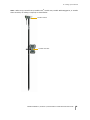
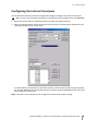
1
user GUIDE TRIMBLE R8 ® Model 4 GNSS Receiver Trimble R6 Model 4 GNSS Receiver Trimble R4 Model 3 GNSS Receiver Version 4.80 Revision A April 2013 Corporate office Canada Trimble Navigation Limited Engineering and Construction group 5475 Kellenburger Road Dayton, Ohio 45424-1099 USA 800-538-7800 (toll free in USA) +1-937-245-5600 Phone +1-937-233-9004 Fax www.trimble.com This digital apparatus does not exceed the Class B limits for radio noise emissions from digital apparatus as set out in the radio interference regulations of the Canadian Department of Communications. This Category II radiocommunication device complies with Industry Canada Standard RSS-310. Le présent appareil numérique n’émet pas de bruits radioélectriques dépassant les limites applicables aux appareils numériques de Classe B prescrites dans le règlement sur le brouillage radioélectrique édicté par le Ministère des Communications du Canada. Ce dispositif de radiocommunication de catégorie II respecte la norme CNR-310 d’Industrie Canada. Legal notices © 2004-2013, Trimble Navigation Limited. Trimble, the Globe & Triangle logo, BlueCap, GPS Total Station, Recon, and TSC2 are trademarks of Trimble Navigation Limited, registered in the United States and in other countries. Access, CMR+, Digital Fieldbook, Maxwell, Trimble Geomatics Office, Trimble Survey Controller, TRIMMARK, TRIMTALK, and TSCe are trademarks of Trimble Navigation Limited. The Bluetooth word mark and logos are owned by the Bluetooth SIG, Inc. and any use of such marks by Trimble Navigation Limited is under license. Microsoft, Windows, and Windows NT are either registered trademarks or trademarks of Microsoft Corporation in the United States and/or other countries. All other trademarks are the property of their respective owners. Release notice This is the April 2013 release (Revision A) of the Trimble R8 Model 4, R6 Model 4, and R4 Model 3 GNSS Receivers User Guide. It applies to version 4.80 of these Trimble receivers. Product Limited Warranty Information Europe This product has been tested and found to comply with the essential requirements for a Class B device pursuant to European Council Directive 1999/5/EC on R&TTE on EMC, thereby satisfying the requirements for CE Marking and sale within the European Economic Area (EEA). These requirements are designed to provide reasonable protection against harmful interference when the equipment is operated in a residential or commercial environment. The 450 MHz band is not harmonised across the European Community. Australia and New Zealand This product conforms with the regulatory requirements of the Australian Communications and Media Authority (ACMA) EMC framework, thus satisfying the requirements for C-Tick Marking, A-Tick Marking and sale within Australia and New Zealand. For applicable product Limited Warranty information, please refer to the Limited Warranty Card included with this Trimble product, or consult your local Trimble authorized distribution partner. Taiwan – Battery Recycling Requirements Product Extended Limited Warranty Information 廢電池請回收 For applicable product Extended Limited Warranty information, please refer to the Limited Warranty Card included with this Trimble product, or consult your Trimble authorized distribution partner. Notices Class B Statement – Notice to Users. This equipment has been tested and found to comply with the limits for a Class B digital device, pursuant to Part 15 of the FCC rules. These limits are designed to provide reasonable protection against harmful interference in a residential installation. This equipment generates, uses, and can radiate radio frequency energy and, if not installed and used in accordance with the instructions, may cause harmful interference to radio communication. However, there is no guarantee that interference will not occur in a particular installation. If this equipment does cause harmful interference to radio or television reception, which can be determined by turning the equipment off and on, the user is encouraged to try to correct the interference by one or more of the following measures: – Reorient or relocate the receiving antenna. – Increase the separation between the equipment and the receiver. – Connect the equipment into an outlet on a circuit different from that to which the receiver is connected. – Consult the distribution partner or an experienced radio/TV technician for help. Changes and modifications not expressly approved by the manufacturer or registrant of this equipment can void your authority to operate this equipment under Federal Communications Commission rules. The product contains a removable Lithium-ion battery. Taiwanese regulations require that waste batteries are recycled. Notice to Our European Union Customers For product recycling instructions and more information, please go to www.trimble.com/ev.shtml. Recycling in Europe: To recycle Trimble WEEE (Waste Electrical and Electronic Equipment, products that run on electrical power.), Call +31 497 53 24 30, and ask for the "WEEE Associate". Or, mail a request for recycling instructions to: Trimble Europe BV c/o Menlo Worldwide Logistics Meerheide 45 5521 DZ Eersel, NL FCC Declaration of Conformity We, Trimble Navigation Limited, 935 Stewart Drive PO Box 3642 Sunnyvale, CA 94088-3642 United States +1-408-481-8000 declare under sole responsibility that the products: Trimble R8 Model 4 GNSS Receiver, Trimble R6 Model 4 GNSS Receiver, and Trimble R4 Model 3 GNSS Receiver comply with Part 15 of FCC Rules. Operation is subject to the following two conditions: (1) this device may not cause harmful interference, and (2) this device must accept any interference received, including interference that may cause undesired operation. TRIMBLE R8 MODEL 4, R6 MODEL 4, AND R4 MODEL 3 GNSS RECEIVERS USER GUIDE 2 RTTE Compliance statements &]HFK 7ULPEOH1DYLJDWLRQ/LPLWHGW¯PWRSURKODģXMHŀHWHQWR>7ULPEOH50RGHO50RGHO50RGHO*166@MHYHVKRGHVH ]£NODGQ¯PLSRŀDGDYN\DGDOģ¯PLSU¯VOXģQ¿PLXVWDQRYHQ¯PLVPHUQLFH(6 'DQLVK 8QGHUWHJQHGH7ULPEOH1DYLJDWLRQ/LPLWHGHUNO¨UHUKHUYHGDWIºOJHQGHXGVW\U>7ULPEOH50RGHO50RGHO50RGHO *166@RYHUKROGHUGHY¨VHQWOLJHNUDYRJºYULJHUHOHYDQWHNUDYLGLUHNWLY() 'XWFK +LHUELMYHUNODDUW7ULPEOH1DYLJDWLRQ/LPLWHGGDWKHWWRHVWHO>7ULPEOH50RGHO50RGHO50RGHO*166@LQ RYHUHHQVWHPPLQJLVPHWGHHVVHQWLOHHLVHQHQGHDQGHUHUHOHYDQWHEHSDOLQJHQYDQULFKWOLMQ(* (QJOLVK +HUHE\7ULPEOH1DYLJDWLRQ/LPLWHGGHFODUHVWKDWWKLVHTXLSPHQW>7ULPEOH50RGHO50RGHO50RGHO*166@LVLQ FRPSOLDQFHZLWKWKHHVVHQWLDOUHTXLUHPHQWVDQGRWKHUUHOHYDQWSURYLVLRQVRI'LUHFWLYH(& (VWRQLDQ .¦HVROHYDJDNLQQLWDE7ULPEOH1DYLJDWLRQ/LPLWHGVHDGPH>7ULPEOH50RGHO50RGHO50RGHO*166@YDVWDYXVW GLUHNWLLYL(S·KLQ·XHWHOHMDQLPHWDWXGGLUHNWLLYLVWWXOHQHYDWHOHWHLVWHOHDVMDNRKDVWHOHV¦WHWHOH *HUPDQ +LHUPLWHUNO¦UW7ULPEOH1DYLJDWLRQ/LPLWHGGDVVVLFKGDV*HU¦W>7ULPEOH50RGHO50RGHO50RGHO*166@LQ EHUHLQVWLPPXQJPLWGHQJUXQGOHJHQGHQ$QIRUGHUXQJHQXQGGHQ¾EULJHQHLQVFKO¦JLJHQ%HVWLPPXQJHQGHU5LFKWOLQLH (*EHILQGHW ˊ˃ˑ˅ˋˎʿˏˍ˒ːʿ7ULPEOH1DYLJDWLRQ/LPLWHG˂˅ˉ˖ˋ˃ˇˍˑˇ>7ULPEOH50RGHO50RGHO50RGHO*166@ ː˒ˊˊˍˏ˓˖ˋ˃ˑʿˇˎˏˍːˑˇːˍ˒ːˇ˖˂˃ˇːʿˎʿˇˑ˅ː˃ˇːˈʿˇˑˇːˉˍˇˎ˃ːː˔˃ˑˇˈ˃ː˂ˇʿˑʿˌ˃ˇːˑ˅ːˍ˂˅ˁˇʿː˃ˈ *UHHN +XQJDULDQ $OXO¯URWW7ULPEOH1DYLJDWLRQ/LPLWHGQ\LODWNR]RPKRJ\D>7ULPEOH50RGHO50RGHO50RGHO*166@PHJIHOHOD YRQDWNR]µDODSYHW·N¸YHWHOP«Q\HNQHN«VD](&LU£Q\HOYHJ\«EHO·¯U£VDLQDN )LQQLVK 7ULPEOH1DYLJDWLRQ/LPLWHGYDNXXWWDDW¦WHQHWW¦>7ULPEOH50RGHO50RGHO50RGHO*166@W\\SSLQHQODLWHRQ GLUHNWLLYLQ(<ROHHOOLVWHQYDDWLPXVWHQMDVLW¦NRVNHYLHQGLUHNWLLYLQPXLGHQHKWRMHQPXNDLQHQ )UHQFK 3DUODSU«VHQWH7ULPEOH1DYLJDWLRQ/LPLWHGG«FODUHTXHO DSSDUHLO>7ULPEOH50RGHO50RGHO50RGHO*166@ HVWFRQIRUPHDX[H[LJHQFHVHVVHQWLHOOHVHWDX[DXWUHVGLVSRVLWLRQVSHUWLQHQWHVGHODGLUHFWLYH&( ,FHODQGLF +«UPH²O¿VLU7ULPEOH1DYLJDWLRQ/LPLWHG\ILUÀY¯D²>7ULPEOH50RGHO50RGHO50RGHO*166@HU¯VDPU¨PL YL²JUXQQNU¸IXURJD²UDUNU¸IXUVHPJHU²DUHUX¯WLOVNLSXQ(& ,WDOLDQ &RQODSUHVHQWH7ULPEOH1DYLJDWLRQ/LPLWHGGLFKLDUDFKHTXHVWR>7ULPEOH50RGHO50RGHO50RGHO*166@ ªFRQIRUPHDLUHTXLVLWLHVVHQ]LDOLHGDOOHDOWUHGLVSRVL]LRQLSHUWLQHQWLVWDELOLWHGDOODGLUHWWLYD&( /DWYLDQ $UģR7ULPEOH1DYLJDWLRQ/LPLWHGGHNODUHND>7ULPEOH50RGHO50RGHO50RGHO*166@DWELOVW'LUHNW7YDV (.E2WLVNDMDP SUDV7EDPXQFLWLHPDUWRVDLVW7WDMLHPQRWHLNXPLHP /LWKXDQLDQ ĢLXR7ULPEOH1DYLJDWLRQ/LPLWHGGHNODUXRMDNDGģLV>7ULPEOH50RGHO50RGHO50RGHO*166@DWLWLQNDHVPLQLXV UHLNDODYLPXVLUNLWDV(%'LUHNW\YRVQXRVWDWDV 0DOWHVH +DZQKHNN7ULPEOH1DYLJDWLRQ/LPLWHGMLGGLNMDUDOLGDQ>7ULPEOH50RGHO50RGHO50RGHO*166@MLNNRQIRUPD PDO-LWLJLMLHWHVVHQ]MDOLXPDSURYYHGLPHQWLR-LUDMQUHOHYDQWLOLKHPPILG'LUUHWWLYD(& 1RUZHJLDQ 7ULPEOH1DYLJDWLRQ/LPLWHGHUNO¨UHUKHUYHGDWXWVW\UHW>7ULPEOH50RGHO50RGHO50RGHO*166@HULVDPVYDU PHGGHJUXQQOHJJHQGHNUDYRJºYULJHUHOHYDQWHNUDYLGLUHNWLY() 3ROLVK 1LQLHMV]\P7ULPEOH1DYLJDWLRQ/LPLWHGR6ZLDGF]D=H>7ULPEOH50RGHO50RGHO50RGHO*166@MHVW]JRGQ\] ]DVDGQLF]\PLZ\PRJDPLRUD]SR]RVWDW\PLVWRVRZQ\PLSRVWDQRZLHQLDPL'\UHNW\Z\(& 3RUWXJXHVH 7ULPEOH1DYLJDWLRQ/LPLWHGGHFODUDTXHHVWH>7ULPEOH50RGHO50RGHO50RGHO*166@HVW£FRQIRUPHFRPRV UHTXLVLWRVHVVHQFLDLVHRXWUDVGLVSRVL©·HVGD'LUHFWLYD&( 6ORYDN 7ULPEOH1DYLJDWLRQ/LPLWHGW¿PWRY\KODVXMHŀH>7ULPEOH50RGHO50RGHO50RGHO*166@ VSLQD]£NODGQ«DYģHWN\SU¯VOXģQ«XVWDQRYHQLD6PHUQLFH(6 6ORYHQLDQ 7ULPEOH1DYLJDWLRQ/LPLWHGL]MDYOMDGDMHWD>7ULPEOH50RGHO50RGHO50RGHO*166@YVNODGX]ELVWYHQLPL ]DKWHYDPLLQRVWDOLPLUHOHYDQWQLPLGRORFLOLGLUHNWLYH(6 6SDQLVK 3RUPHGLRGHODSUHVHQWH7ULPEOH1DYLJDWLRQ/LPLWHGGHFODUDTXHHO>7ULPEOH50RGHO50RGHO50RGHO*166@ FXPSOHFRQORVUHTXLVLWRVHVHQFLDOHV\FXDOHVTXLHUDRWUDVGLVSRVLFLRQHVDSOLFDEOHVRH[LJLEOHVGHOD'LUHFWLYD&( 6ZHGLVK +¦UPHGLQW\JDU7ULPEOH1DYLJDWLRQ/LPLWHGDWWGHQQD>7ULPEOH50RGHO50RGHO50RGHO*166@VW§U, RYHUHQVVWDPPHOVHPHGGHY¦VHQWOLJDHJHQVNDSVNUDYRFK¸YULJDUHOHYDQWDEHVW¦PPHOVHUVRPIUDPJ§UDYGLUHNWLY(* TRIMBLE R8 MODEL 4, R6 MODEL 4, AND R4 MODEL 3 GNSS RECEIVERS USER GUIDE 3 Safety Information This manual describes the Trimble® R8 Model 4, R6 Model 4, and R4 Model 3 GNSS receivers. Before you use your receiver, make sure that you have read and understood this publication, as well as all safety requirements. Warnings and Cautions An absence of specific alerts does not mean that there are no safety risks involved. Always follow the instructions that accompany a Warning or Caution. The information they provide is intended to minimize the risk of personal injury and/or damage to the equipment. In particular, observe safety instructions that are presented in the following formats: C WARNING – A Warning alerts you to a likely risk of serious injury to your person and/or damage to the equipment. A warning identifies the nature of the risk and the extent of possible injury and/or damage. It also describes how to protect yourself and/or the equipment from this risk. Warnings that appear in the text are repeated at the front of the manual. C CAUTION – A Caution alerts you to a possible risk of damage to the equipment and/or loss of data. A Caution describes how to protect the equipment and/or data from this risk. Regulations and safety The receivers contain integral Bluetooth® wireless technology, and may also send radio signals through the antenna of an internal radio-modem, or through an externally-connected data communications radio. Regulations regarding the use of the 450 MHz radio-modems vary greatly from country to country. In some countries, the unit can be used without obtaining an end-user license. Other countries require end-user licensing. For licensing information, consult your local Trimble distribution partner. Bluetooth operates in license-free bands. Type approval Type approval, or acceptance, covers technical parameters of the equipment related to emissions that can cause interference. Type approval is granted to the manufacturer of the transmission equipment, independent from the operation or licensing of the units. Some countries have unique technical requirements for operation in particular radio-modem frequency bands. To comply with those requirements, Trimble may have modified your equipment to be granted Type approval. Unauthorized modification of the units voids the Type approval, the warranty, and the operational license of the equipment. TRIMBLE R8 GNSS, AND R6, R4, AND 5800 MODEL 3 GPS RECEIVERS USER GUIDE 4 Safety Information Operation near other radio equipment When operating the receiver in member states of the European Union and in other counties which adhere to the EU R&TTE requirements, while in the vicinity of aeronautical radionavigation equipment operating between 2700 and 2900 MHz, or Fixed, Fixed Satellite (space to Earth), or Mobile systems operating at 4170 MHz, a minimum separation of 5 meters must be maintained between the receiver and such radio equipment. Exposure to radio frequency radiation For 450 MHz radio Safety. Exposure to RF energy is an important safety consideration. The FCC has adopted a safety standard for human exposure to radio frequency electromagnetic energy. Proper use of this radio modem results in exposure below government limits. The following precautions are recommended: • DO NOT operate the transmitter when someone is within 20 cm (7.8 inches) of the antenna. • DO NOT collocate (place within 20 cm) the radio antenna with any other transmitting antenna. • DO NOT operate the transmitter unless all RF connectors are secure and any open connectors are properly terminated. • DO NOT operate the equipment near electrical blasting caps or in an explosive atmosphere. • All equipment must be properly grounded according to Trimble installation instructions for safe operation. • All equipment should be serviced only by a qualified technician. For GSM radio C CAUTION – For your own safety, and in terms of the RF Exposure requirements of the FCC, always observe the precautions listed here. - Always maintain a minimum separation distance of 20 cm (7.8 inches) between yourself and the radiating antenna on the Trimble R8 Model 4, R6 Model 4, or R4 Model 3 GNSS receiver radio modem. - Do not collocate (place within 20 cm) the radio antenna with any other transmitting antenna. Note – The optional GSM radio cannot legally be operated in Brazil. TRIMBLE R8 GNSS, AND R6, R4, AND 5800 MODEL 3 GPS RECEIVERS USER GUIDE 5 Safety Information For Bluetooth radio The radiated output power of the internal Bluetooth wireless radio is far below the FCC radio frequency exposure limits. Nevertheless, the wireless radio shall be used in such a manner that the Trimble receiver is 20 cm or further from the human body. The internal wireless radio operates within guidelines found in radio frequency safety standards and recommendations, which reflect the consensus of the scientific community. Trimble therefore believes the internal wireless radio is safe for use by consumers. The level of energy emitted is far less than the electromagnetic energy emitted by wireless devices such as mobile phones. However, the use of wireless radios may be restricted in some situations or environments, such as on aircraft. If you are unsure of restrictions, you are encouraged to ask for authorization before turning on the wireless radio. Installing antennas C CAUTION – For your own safety, and in terms of the RF Exposure requirements of the FCC, always observe these precautions: - Always maintain a minimum separation distance of 20 cm (7.8 inches) between yourself and the radiating antenna. - Do not collocate (place within 20cm) the radio antenna with any other transmitting device. This device has been designed to operate with the antennas listed below. UHF Antennas not included in this list, or that have a gain greater than 5 dBi, are strictly prohibited for use with this device. The required antenna impedance is 50 Ω.. The antennas that can be used (country dependent) with the 450 MHz radio are 0 dBi and 5 dBi whip antennas. The antenna that can be used with the GSM radio is the 0 dBi whip antenna. To reduce potential radio interference to other users, the antenna type and its gain should be so chosen that the equivalent isotropically radiated power (e.i.r.p.) is not more than that permitted for successful communication. TRIMBLE R8 GNSS, AND R6, R4, AND 5800 MODEL 3 GPS RECEIVERS USER GUIDE 6 Safety Information Rechargeable Lithium-ion batteries These receivers use a rechargeable Lithium-ion battery. C WARNING – Do not damage the rechargeable Lithium-ion battery. A damaged battery can cause an explosion or fire, and can result in personal injury and/or property damage. To prevent injury or damage: – Do not use or charge the battery if it appears to be damaged. Signs of damage include, but are not limited to, discoloration, warping, and leaking battery fluid. – Do not expose the battery to fire, high temperature, or direct sunlight. – Do not immerse the battery in water. – Do not use or store the battery inside a vehicle during hot weather. – Do not drop or puncture the battery. – Do not open the battery or short-circuit its contacts. C WARNING – Avoid contact with the rechargeable Lithium-ion battery if it appears to be leaking. Battery fluid is corrosive, and contact with it can result in personal injury and/or property damage. To prevent injury or damage: – If the battery leaks, avoid contact with the battery fluid. – If battery fluid gets into your eyes, immediately rinse your eyes with clean water and seek medical attention. Do not rub your eyes! – If battery fluid gets onto your skin or clothing, immediately use clean water to wash off the battery fluid. C WARNING – Charge and use the rechargeable Lithium-ion battery only in strict accordance with the instructions. Charging or using the battery in unauthorized equipment can cause an explosion or fire, and can result in personal injury and/or equipment damage. To prevent injury or damage: – Do not charge or use the battery if it appears to be damaged or leaking. – Charge the Lithium-ion battery only in a Trimble product that is specified to charge it. Be sure to follow all instructions that are provided with the battery charger. – Discontinue charging a battery that gives off extreme heat or a burning odor. – Use the battery only in Trimble equipment that is specified to use it. – Use the battery only for its intended use and according to the instructions in the product documentation. Other Warnings C WARNING – Operating or storing the receiver outside the specified temperature range can damage it. For more information, see Physical specifications, page 42. TRIMBLE R8 GNSS, AND R6, R4, AND 5800 MODEL 3 GPS RECEIVERS USER GUIDE 7 Contents Safety Information . . . . . . . . . . . . . . . . . . . . . . . . . . . . . . . . . . . . . 4 Warnings and Cautions . . . . . . . . . Regulations and safety . . . . . . . . . Type approval . . . . . . . . . . . . . . Operation near other radio equipment Exposure to radio frequency radiation . For 450 MHz radio . . . . . . . . . . For GSM radio . . . . . . . . . . . . For Bluetooth radio . . . . . . . . . Installing antennas. . . . . . . . . . . . Rechargeable Lithium-ion batteries . . Other Warnings . . . . . . . . . . . . . 1 . . . . . . . . . . . . . . . . . . . . . . . . . . . . . . . . . . . . . . . . . . . . . . . . . . . . . . . . . . . . . . . . . . . . . . . . . . . . . . . . . . . . . . . . . . . . . . . . . . . . . . . . . . . . . . . . . . . . . . . . . . . . . . . . . . . . . . . . . . . . . . . . . . . . . . . . . . . . . . . . . . . . . . . . . . . . . . . . . . . . . . . . . . . . . . . . . . . . . . . . . . . . . . . . . . . . . . . . . . . . . . . . . . . . . . . . . . . . . . . . . . . . . . . . . . . . . . . . . . . . . . . . . . . . . . . . . . . . . . . . . . . . . . . . . . . . . . . . . . . . . . . . . . . . . . . . . . . . . . . . . . . . . . . . . . . . . . . . . . . . . . . . . . . . . . . . . . . . . . . . . . . . . . . . . . . . . . . . . . . . . . . . . . . . . . . . . . . . 4 4 4 5 5 5 5 6 6 7 7 Introduction. . . . . . . . . . . . . . . . . . . . . . . . . . . . . . . . . . . . . . . . 10 Related information . . . . . . . . . . . . . . . . . . . . . . . . . . . . . . . . . . . . . . . . . . . . . . .10 Technical assistance . . . . . . . . . . . . . . . . . . . . . . . . . . . . . . . . . . . . . . . . . . . . . . .11 2 Overview . . . . . . . . . . . . . . . . . . . . . . . . . . . . . . . . . . . . . . . . . 12 Features . . . . . . . . . . . . . . . . . . . . . . . . . . . . . . . . . . . . . . . . . . . . . . . . . . . . .13 Use and care . . . . . . . . . . . . . . . . . . . . . . . . . . . . . . . . . . . . . . . . . . . . . . . . . . .14 COCOM limits . . . . . . . . . . . . . . . . . . . . . . . . . . . . . . . . . . . . . . . . . . . . . . . . . .14 3 Setting up the Receiver . . . . . . . . . . . . . . . . . . . . . . . . . . . . . . . . . 15 Parts of the receiver . . . . . . . . . . . . . Front panel . . . . . . . . . . . . . . . . Lower housing . . . . . . . . . . . . . . Setup guidelines . . . . . . . . . . . . . . . Operation near other radio equipment Environmental conditions . . . . . . . . Sources of electrical interference . . . General guidelines . . . . . . . . . . . . Pole-mounted setup . . . . . . . . . . . . . Other system components . . . . . . . . . Radios. . . . . . . . . . . . . . . . . . . Cellular modems and external radios . 4 . . . . . . . . . . . . . . . . . . . . . . . . . . . . . . . . . . . . . . . . . . . . . . . . . . . . . . . . . . . . . . . . . . . . . . . . . . . . . . . . . . . . . . . . . . . . . . . . . . . . . . . . . . . . . . . . . . . . . . . . . . . . . . . . . . . . . . . . . . . . . . . . . . . . . . . . . . . . . . . . . . . . . . . . . . . . . . . . . . . . . . . . . . . . . . . . . . . . . . . . . . . . . . . . . . . . . . . . . . . . . . . . . . . . . . . . . . . . . . . . . . . . . . . . . . . . . . . . . . . . . . . . . . . . . . . . . . . . . . . . . . . . . . . . . . . . . . . . . . . . . . . . . . . . . . . . . . . . . . . . . . . . . . . . . . . . . . . . . . . . . . . . . . . . . . . . . . . . . . . . . . . . . . . . . . . . . . . . . . . . . . . . . . . . . . . . . . . . .16 .16 .17 .18 .18 .18 .18 .19 .19 .21 .21 .21 General Operation . . . . . . . . . . . . . . . . . . . . . . . . . . . . . . . . . . . . 23 Front panel controls . . . . . . . . . Button functions . . . . . . . . . . . LED behavior . . . . . . . . . . . . . LED flash patterns . . . . . . . . Starting and stopping the receiver Logging data . . . . . . . . . . . . . Logging internally . . . . . . . . Logging to a Trimble controller . Resetting to defaults. . . . . . . . . . . . . . . . . . . . . . . . . . . . . . . . . . . . . . . . . . . . . . . . . . . . . . . . . . . . . . . . . . . . . . . . . . . . . . . . . . . . . . . . . . . . . . . . . . . . . . . . . . . . . . . . . . . . . . . . . . . . . . . . . . . . . . . . . . . . . . . . . . . . . . . . . . . . . . . . . . . . . . . . . . . . . . . . . . . . . . . . . . . . . . . . . . . . . . . . . . . . . . . . . . . . . . . . . . . . . . . . . . . . . . . . . . . . . . . . . . . . . . . . . . . . . . . . . . . . . . . . . . . . . . . . . . . . . . . . . . . . . . . . . . . . . . . . . . . . . . . . . . . . . . . . . . . . . . . . . . . . . . . . . . . TRIMBLE R8 MODEL 4, R6 MODEL 4, AND R4 MODEL 3 GNSS RECEIVERS USER GUIDE . . . . . . . . . .23 .24 .24 .24 .25 .25 .25 .26 .26 8 Batteries and power . . . . . . . . Battery charging and storage . Power output . . . . . . . . . Firmware . . . . . . . . . . . . 5 . . . . . . . . . . . . . . . . . . . . . . . . . . . . . . . . . . . . . . . . . . . . . . . . . . . . . . . . . . . . . . . . . . . . . . . . . . . . . . . . . . . . . . . . . . . . . . . . . . . . . . . . . . . . . . . . . . . . . . . . . . . . . . . . . . . . . . . . . . . . . . . . . . . . . . . . . . . . . . . . . . . . . . . . . . . . .26 . 27 .28 .28 . . . . . . . . . . . . . . . . . . . . . . . . . . . . . . . . . . . . . . . . . . . . . . . . . . . . . . . . . . . . . . . . . . . . . . . . . . . . . . . . . . . . . . . . . . . . . . . . . . . . . . . . . . . . . . . . . . . . . . . . . . . . . . . . . . . . . . . . . . . . . . . . . . . . . . . . . . . . . . . . . . . . . . . . . . . . . . . . . . . . . . .29 .30 .30 .30 .31 .31 .32 Software Utilities . . . . . . . . . . . . . . . . . . . . . . . . . . . . . . . . . . . . . 33 The GPS Configurator software . . . . . . . . . . . . . . Installing the GPS Configurator software . . . . . . The WinFlash Utility . . . . . . . . . . . . . . . . . . . . Installing the WinFlash utility . . . . . . . . . . . . . Upgrading firmware . . . . . . . . . . . . . . . . . . Adding frequencies for the 450 MHz internal radio. Configuring the internal transceiver . . . . . . . . . 7 . . . . Configuration . . . . . . . . . . . . . . . . . . . . . . . . . . . . . . . . . . . . . . . 29 Configuring the receiver in real time . . . . . . . Configuring the receiver using application files . Application files . . . . . . . . . . . . . . . . . . Special application files . . . . . . . . . . . . Applying application files . . . . . . . . . . . Storing application files . . . . . . . . . . . . Naming application files. . . . . . . . . . . . 6 . . . . . . . . . . . . . . . . . . . . . . . . . . . . . . . . . . . . . . . . . . . . . . . . . . . . . . . . . . . . . . . . . . . . . . . . . . . . . . . . . . . . . . . . . . . . . . . . . . . . . . . . . . . . . . . . . . . . . . . . . . . . . . . . . . . . . . . . . . . . . . . . . . . . . . . . . . . . . . . . . . . . . . . . . . . . . . . . . . . . . . . . . . .34 .34 .35 .35 .35 .36 .38 Specifications . . . . . . . . . . . . . . . . . . . . . . . . . . . . . . . . . . . . . . . 41 Physical specifications . . . . . . . . . . . . . . . . . . . . . . . . . . . . . . . . . . . . . . . . . . . . 42 Positioning specifications . . . . . . . . . . . . . . . . . . . . . . . . . . . . . . . . . . . . . . . . . . . .42 Technical specifications . . . . . . . . . . . . . . . . . . . . . . . . . . . . . . . . . . . . . . . . . . . . .43 8 Default Settings . . . . . . . . . . . . . . . . . . . . . . . . . . . . . . . . . . . . . . 45 Default settings . . . . . . . Resetting to factory defaults Default behavior . . . . . Power up settings . . . . 9 . . . . . . . . . . . . . . . . . . . . . . . . . . . . . . . . . . . . . . . . . . . . . . . . . . . . . . . . . . . . . . . . . . . . . . . . . . . . . . . . . . . . . . . . . . . . . . . . . . . . . . . . . . . . . . . . . . . . . . . . . . . . . . . . . . . . . . . . . . . . . . . . . . . . . . . . . . . . . . . . . . . . .46 .46 . 47 . 47 Cables and Connectors . . . . . . . . . . . . . . . . . . . . . . . . . . . . . . . . . . 48 Port 1 and 2 connectors . . . . . . . . . . . . . . . . . . . . . . . . . . . . . . . . . . . . . . . . . . . . .49 Power/serial data cables . . . . . . . . . . . . . . . . . . . . . . . . . . . . . . . . . . . . . . . . . . . .50 A NMEA-0183 Output. . . . . . . . . . . . . . . . . . . . . . . . . . . . . . . . . . . . 52 NMEA-0183 outputs . . . . . Common message elements Message values . . . . . NMEA messages . . . . . . . B . . . . . . . . . . . . . . . . . . . . . . . . . . . . . . . . . . . . . . . . . . . . . . . . . . . . . . . . . . . . . . . . . . . . . . . . . . . . . . . . . . . . . . . . . . . . . . . . . . . . . . . . . . . . . . . . . . . . . . . . . . . . . . . . . . . . . . . . . . . . . . . . . . . . . . . . . . . . . . . . . . . . .52 .53 .54 .54 RTCM Output . . . . . . . . . . . . . . . . . . . . . . . . . . . . . . . . . . . . . . . 70 Generated messages . . . . . . . . . . . . . . . . . . . . . . . . . . . . . . . . . . . . . . . . . . . . . .71 Message scheduling . . . . . . . . . . . . . . . . . . . . . . . . . . . . . . . . . . . . . . . . . . . . . . .71 C Troubleshooting . . . . . . . . . . . . . . . . . . . . . . . . . . . . . . . . . . . . . 72 LED conditions . . . . . . . . . . . . . . . . . . . . . . . . . . . . . . . . . . . . . . . . . . . . . . . . . .73 Receiver issues . . . . . . . . . . . . . . . . . . . . . . . . . . . . . . . . . . . . . . . . . . . . . . . . . .73 TRIMBLE R8 MODEL 4, R6 MODEL 4, AND R4 MODEL 3 GNSS RECEIVERS USER GUIDE 9 CHAPTER 1 Introduction Related information Technical assistance 1 The Trimble R8 Model 4, R6 Model 4, and R4 Model 3 GNSS Receivers User Guide describes how to install, set up, and use a Trimble® R8 Model 4, Trimble R6 Model 4, or Trimble R4 Model 3 GNSS receiver. Even if you have used other Global Navigation Satellite System (GNSS) products before, Trimble recommends that you spend some time reading this manual to learn about the special features of your receiver. If you are not familiar with GNSS, visit our website for an interactive look at Trimble and GNSS at www.trimble.com. Trimble assumes that you are familiar with the Windows® operating system and know how to use a mouse, select options from menus and dialogs, make selections from lists, and refer to online help. Related information An electronic copy of this manual is available in portable document format (PDF) at www.trimble.com. Use Adobe Reader to view the contents of this file. Other sources of related information are: • Release notes – the release notes describe new features of the product, information not included in the manual, and any changes to the manual. They are provided as a PDF at www.trimble.com. Use Adobe Reader to view the contents of the release notes. • Registration – register your receiver to automatically receive e-mail notifications of receiver firmware upgrades and new functionality. To register, go to www.trimble.com. Contact your local Trimble distribution partner for more information about the support agreement contracts for software and firmware, and an extended warranty program for hardware. • Trimble training courses – consider a training course to help you use your GNSS system to its fullest potential. For more information, visit the Trimble website at www.trimble.com/training.html. TRIMBLE R8 MODEL 4, R6 MODEL 4, AND R4 MODEL 3 GNSS RECEIVERS USER GUIDE 10 1 – Introduction Technical assistance If you have a problem and cannot find the information you need in the product documentation, contact your local distribution partner. Alternatively, request technical support using the Trimble website at (www.trimble.com/support.html). TRIMBLE R8 MODEL 4, R6 MODEL 4, AND R4 MODEL 3 GNSS RECEIVERS USER GUIDE 11 CHAPTER 2 Overview Features Use and care COCOM limits 2 This chapter introduces the Trimble R8 Model 4, R6 Model 4, and R4 Model 3 GNSS receivers for GNSS surveying applications. The receiver incorporates a GNSS antenna, receiver, internal radio with a transmit option or an internal GSM module, and a battery in a rugged light-weight unit that is ideally suited as an all-onthe-pole RTK rover. Three LEDs allow you to monitor the satellite tracking, radio reception, data logging status, and power. Bluetooth wireless technology provides cable-free communications between receiver and controller. • The circuitry in the Trimble R8 Model 4 GNSS receiver provides up to 440 channels for satellite tracking, and supports logging raw GNSS observables to the internal receiver memory or to a handheld controller for postprocessed applications. • The Trimble R6 Model 4 GNSS receiver provides 220 channels for satellite tracking, and supports logging raw GNSS observables to the internal receiver memory or to a handheld controller for postprocessed applications. • The Trimble R4 Model 3 GNSS receiver provides 220 channels for satellite tracking, and supports logging raw GNSS observables to the internal receiver memory or to a handheld controller for postprocessed applications. The receiver is available as a standalone rover, base station, or as part of the GNSS Total Station® system, offering maximum versatility in the system configuration to meet your specific requirements. TRIMBLE R8 MODEL 4, R6 MODEL 4, AND R4 MODEL 3 GNSS RECEIVERS USER GUIDE 12 2 – Overview Features The receivers provide the following features: • Future-proof Trimble 360 technology (Trimble R8 Model 4), which includes advanced Trimble Maxwell 6 Custom Survey GNSS chips with 440 channels and allows the receiver to track the following: – GPS: L1 C/A, L1C, L2C, L2E, L5 – GLONASS: L1 C/A, L1P, L2 C/A, L2P, L3 – Galileo: E1, E5A, E5B – BeiDou (COMPASS): B1, B2 – SBAS: QZSS, WAAS, EGNOS, GAGAN • Trimble R-track technology (Trimble R6 Model 4), which includes an advanced Trimble Maxwell 6 Custom Survey GNSS chip with 220 channels and allows the receiver to track the following: – GPS: L1 C/A, L1C, L2C, L2E, L5 – GLONASS: L1 C/A, L1P, L2 C/A, L2P, L3 (optional) – Galileo: E1, E5A, E5B (optional) – BeiDou (COMPASS): B1, B2 (optional) – SBAS: QZSS, WAAS, EGNOS, GAGAN • Trimble R-track technology (Trimble R4 Model 3), which includes an advanced Trimble Maxwell 6 Custom Survey GNSS chip with 220 channels and allows the receiver to track the following: – GPS: L1 C/A, L1C, L2C, L2E – GLONASS: L1 C/A, L1P, L2 C/A, L2P, L3 (optional) – Galileo: E1, E5A, E5B (optional) – BeiDou (COMPASS): B1, B2 (optional) – SBAS: QZSS, WAAS, EGNOS, GAGAN • Centimeter-accuracy, real-time positioning with RTK/OTF data, up to 20 Hz position updates (R8 Model 4) or up to 10 Hz (R6 Model 4 and R4 Model 3) • Submeter-accuracy, real-time positioning using pseudorange corrections • Automatic OTF (on-the-fly) initialization while moving • Single Lithium-ion rechargeable battery • Cable-free Bluetooth communications with Trimble controllers • Two RS-232 serial ports for: – Trimble Format (CMR, CMR+™ and CMRx) input and output – RTCM SC-104 input and output (RTCM 2.1, 2.3, 3.0, 3.1) – 23 NMEA outputs – GSOF, RT17, and RT27 outputs – Supports BINEX and smoothed carrier TRIMBLE R8 MODEL 4, R6 MODEL 4, AND R4 MODEL 3 GNSS RECEIVERS USER GUIDE 13 2 – Overview • One TNC radio antenna connector • Internal memory for data storage • Internal 450 MHz radio with a transmit option or GSM/GPRS options Use and care The receiver can withstand the rough treatment that typically occurs in the field. However, it is a high-precision electronic instrument and should be treated with reasonable care. C WARNING – Operating or storing the receiver outside the specified temperature range can damage it. For more information, see Chapter 7, Specifications. High-power signals from a nearby radio or radar transmitter can overwhelm the receiver circuits. This does not harm the instrument, but it can prevent the receiver electronics from functioning correctly. Avoid using the receiver within 400 meters of powerful radar, television, or other transmitters. Low-power transmitters such as those used in cellphones and two-way radios normally do not interfere with receiver operations. For more information, contact your local Trimble distributor. COCOM limits The U.S. Department of Commerce requires that all exportable GPS products contain performance limitations so that they cannot be used in a manner that could threaten the security of the United States. The following limitations are implemented on the receiver. Immediate access to satellite measurements and navigation results is disabled when the receiver’s velocity is computed to be greater than 1000 knots, or its altitude is computed to be above 18,000 meters. The receiver continuously resets until the COCOM situation is cleared. TRIMBLE R8 MODEL 4, R6 MODEL 4, AND R4 MODEL 3 GNSS RECEIVERS USER GUIDE 14 CHAPTER 3 Setting up the Receiver Parts of the receiver Setup guidelines Pole-mounted setup Other system components 3 This chapter provides general information on setup, connection, and cabling for the most common uses of the receiver. TRIMBLE R8 MODEL 4, R6 MODEL 4, AND R4 MODEL 3 GNSS RECEIVERS USER GUIDE 15 3 – Setting up the Receiver Parts of the receiver All operating controls on the receiver are located on the front panel. Serial ports and connectors are located on the bottom of the unit. Front panel The following figure shows the receiver front panel, which contains the three indicator light emitting diodes (LEDs), and the Power button. The Power button controls the receiver’s power on or off functions. The indicator LEDs show the status of power, satellite tracking, and radio reception. For more information, see LED behavior, page 24. TRIMBLE R8 MODEL 4, R6 MODEL 4, AND R4 MODEL 3 GNSS RECEIVERS USER GUIDE 16 3 – Setting up the Receiver Lower housing The following figure shows the receiver lower housing, which contains the two serial ports, one TNC radio antenna or GSM antenna connector (depending on the internal communication module ordered), the removable battery compartment and the 5/8-11 threaded insert. Radio antenna connection Port 2 Port 1 Each port or connector on the receiver is marked with an icon to indicate its main function as shown below. Icon Name Connections Port 1 Device, computer, external radio, power in Port 2 Device, computer, external radio RADIO Radio communications antenna Port 1 is a 7-pin 0-shell Lemo connector that supports RS-232 comms and external power input. Port 1 has no power outputs. Port 2 is a DB-9 male connector that allows for full 9-pin RS-232 comms. Port 2 does not support power in or out. For more information, see Chapter 8, Default Settings and Chapter 9, Cables and Connectors. The TNC connector is for connecting a radio antenna to the receiver internal radio. A whip “rubber duck” antenna is supplied with the system for units with internal UHF radios. This connector is not used if you are using an external UHF radio or GSM. TRIMBLE R8 MODEL 4, R6 MODEL 4, AND R4 MODEL 3 GNSS RECEIVERS USER GUIDE 17 3 – Setting up the Receiver External UHF or GSM antenna Depending on which module you have purchased, use this TNC connection for an external antenna for the UHF or GSM antenna. The UHF and GSM antennas are both approximately 16.5 cm long. The UHF antennas have color coded dots on the top where the GSM antenna has a black cap. For more information on connecting the receiver, see the following sections in this chapter. Setup guidelines Consider the following guidelines when setting up the receiver. C CAUTION – To satisfy the RF Exposure requirements of the FCC, you must maintain a minimum separation distance of 20 cm (approximately 8 in.) between yourself and the radiating UHF or GSM antenna for this device. For mobile operation, the maximum gain of the UHF or GSM antenna must not exceed 0 dBi. Operation near other radio equipment When operating the receiver in member states of the European Union and in other counties which adhere to the EU R&TTE requirements, while in the vicinity of aeronautical radionavigation equipment operating between 2700 and 2900 MHz, or Fixed, Fixed Satellite (space to Earth) or Mobile systems operating at 4170 MHz, a minimum separation of 5 meters must be maintained between the receiver and such radio equipment. Environmental conditions Although the receiver has a waterproof housing, take reasonable care to protect the unit. Avoid exposure to extreme environmental conditions, including: • Water • Heat greater than 65 °C (149 °F) • Cold less than –40 °C (–40 °F) • Corrosive fluids and gases Sources of electrical interference Avoid the following sources of electrical and magnetic noise: • Gasoline engines (spark plugs) • Televisions and PC monitors • Alternators and generators • Electric motors • Equipment with DC-to-AC converters TRIMBLE R8 MODEL 4, R6 MODEL 4, AND R4 MODEL 3 GNSS RECEIVERS USER GUIDE 18 3 – Setting up the Receiver • Fluorescent lights • Switching power supplies General guidelines C WARNING – These receivers use a rechargeable Lithium-ion battery. To avoid personal injury or equipment damage, make sure that you read and understand the Safety Information on page 4 at the front of this manual. The following guidelines apply whenever you set up the receiver for operation: • When plugging in a Lemo cable, make sure that the red dots on the receiver port and the cable connector line up. Do not use force to plug cables in, as this may damage the connector pins. • When disconnecting a Lemo cable, grasp the cable by the sliding collar or lanyard and then pull the cable connector straight out of the port. Do not twist the connector or pull on the cable itself. • To securely connect a TNC cable, align the cable connector with the receiver receptacle and then thread the cable connector onto the receptacle until it is snug. • To insert the internal battery, place the battery in the battery compartment, ensuring that the contact points are in the correct position to align with the contacts in the receiver. Slide the battery and compartment as a unit upward into the receiver until the battery compartment latches are locked into position. Pole-mounted setup The following figure shows the pole-mounted setup for the receiver. To mount the receiver on a range pole: 1. Thread the receiver onto the range pole. 2. Attach the controller bracket to the pole. 3. Insert the controller into the bracket. TRIMBLE R8 MODEL 4, R6 MODEL 4, AND R4 MODEL 3 GNSS RECEIVERS USER GUIDE 19 3 – Setting up the Receiver Note – When using a Trimble TSC3, Trimble TSC2,® Trimble TCU, Trimble Tablet Rugged PC, or Trimble Slate controller, no cabling is required, as shown below. Trimble receiver Trimble controller TRIMBLE R8 MODEL 4, R6 MODEL 4, AND R4 MODEL 3 GNSS RECEIVERS USER GUIDE 20 3 – Setting up the Receiver Other system components This section describes optional components that you can use with the receiver. Radios Radios are the most common data link for Real-Time Kinematic (RTK) surveying. The receiver is available with an optional internal radio in the 450 MHz UHF band, or with an internal GSM module. You can also connect an external radio to either receiver port, whether or not the internal radio is installed. The receiver supports the following Trimble base radios with the internal 450 MHz radio: • Trimble TDL 450L • Trimble HPB450 • Trimble PDL450 • Receiver internal 450 MHz transmitter • TRIMMARK™ 3 radio • SiteNet™ 450 radio Internal GSM setup You can configure the optional internal GSM Module using the Trimble Access™ or Trimble Survey Controller™ software. For more information, refer to the field software documentation. Internal radio setup To configure the receiver optional internal radio, use one of the following: • The GPS Configurator software • The WinFlash utility • The Trimble Access software • The Trimble Survey Controller software For more information, refer to the documentation for these applications. By default, the internal radio has only a few “test” frequencies installed at the factory. If you purchased the transmit option, the broadcast frequencies must be programmed by the Trimble distribution partner. You can program the receive frequencies using the WinFlash utility. For more information, see The WinFlash Utility, page 35. Cellular modems and external radios For a data communications link, you can use an internal or external radio, or an internal or external cellular modem. To connect an external cellular modem to the receiver, you need the following: • A Trimble R8 Model 4, R6 Model 4, or R4 Model 3 GNSS receiver. TRIMBLE R8 MODEL 4, R6 MODEL 4, AND R4 MODEL 3 GNSS RECEIVERS USER GUIDE 21 3 – Setting up the Receiver • A cellular modem, or a cellphone that can transmit and receive data. • Serial (cellphone to DB9) cable (supplied with the cellular modem or phone). • Port 2 of the receiver supports full RS-232 protocol, and should function properly with most cellular phone cables. Some cellular units may require custom cabling. Alternatively, the receiver also supports a cable-free Bluetooth connection with Bluetoothenabled cell phones. For more information on using an external cellular modem as a data link, refer to the Trimble Access or Trimble Survey Controller documentation. To connect an external radio modem to a receiver, you need the following: • A receiver. • An external radio capable of receiving and decoding Trimble data packets. • Serial cable for either Port 1 or Port 2 of the receiver, as supplied by the radio manufacturer. • Radio mount for the range pole. TRIMBLE R8 MODEL 4, R6 MODEL 4, AND R4 MODEL 3 GNSS RECEIVERS USER GUIDE 22 CHAPTER 4 General Operation 4 All the controls that you need for general receiver operation are on the front panel. Front panel controls Button functions LED behavior Starting and stopping the receiver Logging data Resetting to defaults Batteries and power For more information about other receiver panels, see Parts of the receiver, page 16. Front panel controls The following figure shows the receiver front panel controls for the power on/off functions, or receiver reset. The LEDs provide power, radio, data logging, and SV tracking status information. F Power button Power/Data status Radio SV Tracking LEDs TRIMBLE R8 MODEL 4, R6 MODEL 4, AND R4 MODEL 3 GNSS RECEIVERS USER GUIDE 23 4 – General Operation Button functions The receiver has only one button, the Power button. Press the Power button to turn on or turn off the receiver, and to perform other functions, as described below. C CAUTION – Do not hold down the Power button for more than 30 seconds. After 30 seconds, any application files stored in the receiver are deleted. To … Power button turn on the receiver Press turn off the receiver Hold for 2 seconds delete the ephemeris file Hold for 15 seconds reset the receiver to factory defaults Hold for 15 seconds delete application files Hold for 30 seconds Note – The term “press” means to press the button and release it immediately. The term “hold” means to press the button and hold it down for the given time. LED behavior The three LEDs on the front panel of the receiver indicate various operating conditions. Generally, a lit or slowly flashing LED indicates normal operation, a LED that is flashing quickly indicates a condition that may require attention, and an unlit LED indicates that no operation is occurring. The following table defines each possible LED state. The term … means that the LED … Slow flash alternates on/off for 500 milliseconds. Fast flash alternates rapidly on/off for 100 milliseconds On is lit Off is unlit LED flash patterns The following table details the possible flash patterns to indicate various states of receiver operation. Receiver mode Power LED Radio LED Satellite LED Green Green Amber Receiver OFF OFF OFF OFF Receiver ON: Healthy power ON N/A N/A Low power Fast flash N/A N/A Tracking <4 SVs ON N/A Fast flash Tracking >4 SVs ON N/A Slow flash TRIMBLE R8 MODEL 4, R6 MODEL 4, AND R4 MODEL 3 GNSS RECEIVERS USER GUIDE 24 4 – General Operation Receiver mode Power LED Radio LED Satellite LED Green Green Amber Logging data internally Flashes off every N/A 3 seconds N/A Transmitting internally N/A Flashes off when transmitting N/A Receiving valid data packets ON Slow flash N/A No data packets ON OFF N/A Receiver in Monitor ON Slow flash ON Note – If a column shows “N/A”, that specific LED may or may not be on, but it is not relevant to that particular mode. Starting and stopping the receiver To turn on the receiver, press the Power button. To turn off the receiver, hold down the Power button for two seconds. Logging data You can log data internally or to a Trimble controller. Logging internally The receiver logs raw data on internal memory. You can then use the Trimble Data Transfer utility or Trimble Business Center software to transfer logged data files to the office computer. Note – If you use the Data Transfer utility to download the internally-logged files, a DAT (*.dat) file is automatically created after the download. DAT files do not contain GLONASS data. If you haveTrimble Business Center software, the T0x (T01 or T02) file that is stored on the receiver can be directly downloaded. The T0x files contain any collected GLONASS data. Trimble Business Center software can process GLONASS data, if you purchased that option. C CAUTION – The receiver allows for a maximum of 200 files on the internal memory. The filenames must be in 8.3 format, otherwise, files copied to the internal memory may cause data corruption or loss of data when logging. Data is logged using the current logging settings configured in the receiver. Data files logged internally are named automatically. To begin internal logging, you must use a Trimble controller, or the GPS Configurator software. The receiver does not have a continuously running internal clock when it is turned off, so you can conduct timed survey sessions only if the receiver is turned on and connected to a power source. TRIMBLE R8 MODEL 4, R6 MODEL 4, AND R4 MODEL 3 GNSS RECEIVERS USER GUIDE 25 4 – General Operation When the internal memory is full, the receiver stops logging data, and the Power LED stops flashing and remains on continuously. Existing data files are not overwritten. You can use the Auto-delete option to override this action and automatically delete the oldest files when the receiver memory is full. However, you should use this option with caution because it can result in loss of data. Approximate storage requirements for different logging rates are shown below. The values shown are for a one-hour logging session with six satellites visible. Logging rate Memory required 10 Hz 2,588 KB 1 Hz 335 KB 5 seconds 87 KB 15 seconds 37 KB Logging to a Trimble controller When the receiver is connected to a Trimble controller, you can log GPS data from the receiver to the controller, or to a data card inserted in the controller. When you use a Trimble controller, you do not use the receiver’s controls. Instead, you use the controller functions to set logging options, specify filenames, and control when logging occurs. Controller software job files and the corresponding raw data files can be transferred to an office computer using the Trimble Data Transfer utility. For more information on logging data from a receiver using a Trimble controller, refer to the user guide for your particular controller. Resetting to defaults To reset the receiver to its factory default settings, hold down the Power button for at least 15 seconds. For more information, see Default settings, page 46. Batteries and power C WARNING – Do not damage the rechargeable Lithium-ion battery. A damaged battery can cause an explosion or fire, and can result in personal injury and/or property damage. To prevent injury or damage: – Do not use or charge the battery if it appears to be damaged. Signs of damage include, but are not limited to, discoloration, warping, and leaking battery fluid. – Do not expose the battery to fire, high temperature, or direct sunlight. – Do not immerse the battery in water. – Do not use or store the battery inside a vehicle during hot weather. – Do not drop or puncture the battery. – Do not open the battery or short-circuit its contacts. TRIMBLE R8 MODEL 4, R6 MODEL 4, AND R4 MODEL 3 GNSS RECEIVERS USER GUIDE 26 4 – General Operation The receiver can be powered by its internal battery or by an external power source connected to Port 1. If an external power source is connected to Port 1, it is used in preference to the internal battery. When there is no external power source connected, or if the external power supply fails, the internal battery is used. C WARNING – Avoid contact with the rechargeable Lithium-ion battery if it appears to be leaking. Battery fluid is corrosive, and contact with it can result in personal injury and/or property damage. To prevent injury or damage: – If the battery leaks, avoid contact with the battery fluid. – If battery fluid gets into your eyes, immediately rinse your eyes with clean water and seek medical attention. Do not rub your eyes! – If battery fluid gets onto your skin or clothing, immediately use clean water to wash off the battery fluid. The receiver is supplied with two rechargeable Lithium-ion batteries, and a dual battery charger. Charge the Lithium-ion batteries only in a Trimble battery charger, such as the dual battery charger P/N 61116-00 (black) or P/N 53018010 (grey), or the five-battery system charger P/N 49499-00 (yellow/grey) or another charger specified for this battery. The two batteries charge sequentially and take approximately four hours each to fully charge. Battery charging and storage All battery types discharge over time when they are not being used. Batteries also discharge faster in colder temperatures. If a Lithium-ion battery is to be stored for long periods of time, make sure it is fully charged before storing and re-charged at least every three months. C WARNING – Charge and use the rechargeable Lithium-ion battery only in strict accordance with the instructions. Charging or using the battery in unauthorized equipment can cause an explosion or fire, and can result in personal injury and/or equipment damage. To prevent injury or damage: – Do not charge or use the battery if it appears to be damaged or leaking. – Charge the Lithium-ion batteries only in a Trimble battery charger, such as the dual battery charger P/N 61116-00 (black) or P/N 53018010 (grey), or the five-battery system charger P/N 49499-00 (yellow/grey) or another charger specified for this battery. Be sure to follow all instructions that are provided with the battery charger. – Discontinue charging a battery that gives off extreme heat or a burning odor. – Use the battery only in Trimble equipment that is specified to use it. – Use the battery only for its intended use and according to the instructions in the product documentation. Charging the Lithium-ion battery The rechargeable Lithium-ion battery is supplied partially charged. Charge the battery completely before using it for the first time. If the battery has been stored for longer than six months, charge it before use. TRIMBLE R8 MODEL 4, R6 MODEL 4, AND R4 MODEL 3 GNSS RECEIVERS USER GUIDE 27 4 – General Operation To protect the battery from deep discharge (5 V or less), the receiver is designed to switch batteries or cease drawing power when the battery pack discharges to 5.9 V. A battery that has reached the deep discharge level cannot be recharged and must be replaced. The following recommendations provide optimal performance and extend the life of your batteries: • Fully charge all new batteries prior to use. • Do not allow the batteries to discharge below 5 V. • Keep all batteries on continuous charge when not in use. Batteries may be kept on charge indefinitely without damage to the receiver or batteries. • Do not store batteries in the receiver or external charger unless power is applied. • If you must store the batteries, fully charge them before storing and then recharge them at least every three months. Disposing of the rechargeable Lithium-ion battery Discharge the Lithium-ion battery before disposing of it. When disposing of the battery, be sure to do so in an environmentally sensitive manner. Adhere to any local and national regulations concerning battery disposal or recycling. Power output The receiver does not supply power from either of its two ports. Firmware A receiver’s firmware is the program inside the receiver that controls receiver operations and hardware. You can upgrade the firmware for the receiver using the WinFlash utility which can be downloaded from www.trimble.com. For more information, see The WinFlash Utility, page 35. C CAUTION – Downgrading the firmware deletes all application files on the receiver. TRIMBLE R8 MODEL 4, R6 MODEL 4, AND R4 MODEL 3 GNSS RECEIVERS USER GUIDE 28 CHAPTER 5 Configuration Configuring the receiver in real time Configuring the receiver using application files Application files 5 The receiver has no controls to change settings. To configure the receiver, use external software such as GPS Configurator, WinFlash, Trimble Access, or Trimble Survey Controller. To configure the receiver, do one of the following: • Configure the receiver in real time. • Apply the settings in an application file. This chapter provides a brief overview of each of these methods and describes the contents and use of application files. Configuring the receiver in real time GPS Configurator, Trimble Access, and Trimble Survey Controller software support real-time configuration of the receiver. When you configure the receiver in real time, you use one of these software applications to specify which settings you want to change. When you apply the changes, the receiver settings change immediately. Any changes that you apply to the receiver are reflected in the current application file, which is always present in the receiver. The current application file always records the most recent configuration, so if you apply further changes (either in real time or using an application file) the current file is updated and there is no record of the changes that you applied originally. For more information on configuring the receiver in real time, see Chapter 6, Software Utilities. TRIMBLE R8 MODEL 4, R6 MODEL 4, AND R4 MODEL 3 GNSS RECEIVERS USER GUIDE 29 5 – Configuration Configuring the receiver using application files An application file contains information for configuring a receiver. To configure a receiver using an application file, you need to create the application file, transfer it to the receiver and then apply the file’s settings. The GPS Configurator software does this automatically when you work with application files. For more information on applying application files, see Chapter 6, Software Utilities. Application files An application file is organized into records. Each record stores configuration information for a particular area of receiver operation. Application files can include the following records: • File Storage • General Controls • Serial Port Baud/Format • Reference Position • Logging Rate • SV Enable/Disable • Output Message • Antenna • Device Control • Static/Kinematic • Input Message An application file does not have to contain all of these records. When you apply an application file, any option that is not included in the records in the file remains at its current setting. For example, if you apply an application file that only specifies the elevation mask to use, all other settings remain as they were before the application file was applied. You can store up to ten different application files in the receiver. You can apply an application file’s settings at the time it is transferred to the receiver, or at any time afterwards. Special application files The receiver has two special application files, which control important aspects of the receiver’s configuration. Current application file The current application file (Current.cfg) reflects the current receiver configuration. Whenever you change the receiver’s configuration, either in real time or by applying an application file, the current file changes to match the new configuration. TRIMBLE R8 MODEL 4, R6 MODEL 4, AND R4 MODEL 3 GNSS RECEIVERS USER GUIDE 30 5 – Configuration You cannot delete the current file or change it directly, but every change to the receiver’s current configuration is applied to the current file as well. When you switch off the receiver then turn it on again, all the settings from the current application file are applied, so you do not lose any changes that you have made. The only exceptions are the following logging parameters: • Logging rate • Position rate • Elevation mask These parameters are always reset to the factory default values whenever the receiver is switched off. Power up application file The power up application file (Power_up.cfg) is used to set the receiver to a specific configuration any time the unit is turned on. In this file, you can specify that the receiver is reset to defaults before the power up settings are applied. This ensures that restarting the receiver always results in the same configuration. This method is useful for defining “default” settings for the receiver that differ from those in the default file, which cannot be changed. Alternatively, you can specify that the power up settings are applied immediately after the current application file’s settings have been applied. Restarting the receiver results in a configuration that uses your default settings for the options you define in the power up file, but the current settings for all other options. By default, there is no power_up application file on the receiver. To use a power up application file, you must create and save a power_up application file in the GPS Configurator software. If you save this file to disk, the file is called power_up.cfg. The extension .cfg is used, by convention, to identify application files on the office computer. When you transfer this file to the receiver, the file is saved on the receiver as power_up, and becomes the new power up file. Applying application files An application file’s settings do not affect the receiver’s configuration until you apply the application file. You can do this at the same time that you save the file. Alternatively, you can save the file on the computer or in the receiver, then open it later and apply its settings. Storing application files You can store application files that you create in the GPS Configurator software on the receiver and on the computer. For example, each file can represent a different user sharing the same receiver, or a particular mode of operation or survey style. Saving application files on your computer as well as in your receiver is optional, but it is useful because: • it gives you a permanent copy of the settings you have sent to a receiver, for audit or your own reference. • you can use the same file to configure multiple receivers identically. TRIMBLE R8 MODEL 4, R6 MODEL 4, AND R4 MODEL 3 GNSS RECEIVERS USER GUIDE 31 5 – Configuration • you can use an existing application file as a template to create other application files with similar settings. Naming application files The application filename in the office computer and in the receiver are always the same. This makes it easier to recognize and keep track of your application files. When you change the name of the application file in the receiver, this changes the application filename on your computer. When you transfer an application file from the receiver and save it to the computer, the system renames the file to match the internal receiver file. However, if you use Windows Explorer, for example, to change the .cfg filename on the computer, this does not change the internal receiver filename. This means that the GPS receiver does not recognize the change to the filename on the computer. TRIMBLE R8 MODEL 4, R6 MODEL 4, AND R4 MODEL 3 GNSS RECEIVERS USER GUIDE 32 CHAPTER 6 Software Utilities The GPS Configurator software The WinFlash Utility 6 This chapter describes the software utilities that you can use with the receiver. TRIMBLE R8 MODEL 4, R6 MODEL 4, AND R4 MODEL 3 GNSS RECEIVERS USER GUIDE 33 6 – Software Utilities The GPS Configurator software GPS Configurator is office software that configures selected Trimble GNSS receivers. GPS Configurator software enables you to: • edit and save configuration files to the receiver and the computer • check current receiver settings and operation • configure receiver settings with your office computer Installing the GPS Configurator software GPS Configurator can be downloaded from www.trimble.com. 1. Start the GPS Configurator installer. 2. From the main menu, select Install individual software packages. 3. Select Install GPS Configurator vX.XX. 4. Follow the onscreen instructions. Configuring the receiver using GPS Configurator software 1. Connect Port 1 or 2 on the receiver to a serial (COM) port on the computer and apply power. 2. To start GPS Configurator, from the Start menu select Programs / Trimble / GPS Configurator / GPS Configurator. 3. In the Device Type dialog, select Trimble R8/R6/R4. The software automatically establishes a connection with the receiver. 4. Make appropriate selections for your required receiver settings. For more information, refer to the GPS Configurator Help. 5. Click Apply. The settings in GPS Configurator software are applied to the receiver. TRIMBLE R8 MODEL 4, R6 MODEL 4, AND R4 MODEL 3 GNSS RECEIVERS USER GUIDE 34 6 – Software Utilities The WinFlash Utility The WinFlash utility communicates with Trimble products to perform various functions including: • installing software, firmware, and option upgrades • running diagnostics (for example, retrieving configuration information) • configuring radios For more information, online help is also available when using the WinFlash utility. Note – The WinFlash utility runs on Windows 2000, XP, Windows Vista,® or Windows 7 operating systems. Installing the WinFlash utility 1. Start the WinFlash utility installer. 2. From the main menu, select Install individual software packages. 3. Select Install WinFlash vX.XX for R/5000/NetR5 receivers and then follow the on-screen instructions. Upgrading firmware Your receiver is supplied with the latest version of receiver firmware installed. If a later version becomes available, upgrade the firmware installed on your receiver. The WinFlash utility guides you through the firmware upgrade process. The steps required are described below. For more information, refer to the WinFlash Help. To upgrade the receiver firmware: 1. Start the WinFlash utility. The Device Configuration screen appears. 2. From the Device type list, select Trimble R8/R6/R4. 3. From the PC serial port field, select the serial (COM) port on the computer that the receiver is connected to. 4. Click Next. The Operation Selection screen appears. The Operations list shows all of the supported operations for the selected device. A description of the selected operation is shown in the Description field. 5. Select GPS software upgrade and click Next. The GPS Software Selection window appears. This screen prompts you to select the software that you want to install on the receiver. 6. Select the latest version from the Available Software list and then click Next. The Settings Review window appears. This screen prompts you to connect the receiver, suggests a connection method and then lists the receiver configuration and selected operation. TRIMBLE R8 MODEL 4, R6 MODEL 4, AND R4 MODEL 3 GNSS RECEIVERS USER GUIDE 35 6 – Software Utilities 7. If all is correct, click Finish. Based on your selections, the Software Upgrade window appears and shows the status of the operation (for example, Establishing communication with the Rx GNSS. Please wait ...) 8. Click OK. The Software Upgrade window appears again and states that the operation was completed successfully. 9. Click Menu to select another operation, or click Exit to quit WinFlash. 10. If you click Exit, another screen appears asking you to confirm that you want to quit. Click OK. Adding frequencies for the 450 MHz internal radio If your receiver has the optional internal radio installed, you can use the WinFlash utility to add receiving frequencies to the default list. If you purchase a transmit upgrade (after initial purchase), the broadcast frequencies must be programmed using a .set file obtained from a Trimble service provider. 1. Start the WinFlash utility. The Device Configuration screen appears. 2. From the Device type list, select the appropriate receiver name. 3. From the PC serial port field, select the serial (COM) port on the computer that the receiver is connected to. 4. Click Next. The Operation Selection screen appears. The Operations list shows all of the supported operations for the selected device. A description of the selected operation is shown in the Description field. 5. Select Configure Radio and then click Next. TRIMBLE R8 MODEL 4, R6 MODEL 4, AND R4 MODEL 3 GNSS RECEIVERS USER GUIDE 36 6 – Software Utilities The Frequency Selection dialog appears: 6. In the Wireless Format group, select the appropriate channel and wireless mode. The Wireless Mode must be the same for all radios in your network. 7. In the Specify Frequency field, enter the frequency you require. 8. Click Add. The new frequency appears in the Selected Frequencies list. Note – The frequencies that you program must conform to the channel spacing and minimum tuning requirements for the radio. To view this information, click Radio Info. You may select either 12.5 or 25 kHz channel spacing. All radios in your network must use the same channel spacing. 9. When you have configured all the frequencies you require, click OK. The WinFlash utility updates the receiver radio frequencies and then restarts the receiver. Note – You can only configure receive frequencies. The FCC approved transmit frequencies must be specified and configured by the Trimble distribution partner. TRIMBLE R8 MODEL 4, R6 MODEL 4, AND R4 MODEL 3 GNSS RECEIVERS USER GUIDE 37 6 – Software Utilities Configuring the internal transceiver Use the WinFlash Internal Transceiver Configuration dialog to configure the internal transceiver. B Tip – To view a list of all radio information, including the current configuration, click Radio Info. 1. Select the Current Channel, which determines the radio operating frequency. 2. Select the Wireless Mode, which determines the over-the-air communications parameters. The following example shows a rover setup: To reduce battery consumption on your base receiver, set the wireless mode as high as possible. For example, 9600 bits per second (bps) consumes half the power of 4800 bps for the same data format and time of operation. Note – All radios in the network must be configured with the same wireless setting. TRIMBLE R8 MODEL 4, R6 MODEL 4, AND R4 MODEL 3 GNSS RECEIVERS USER GUIDE 38 6 – Software Utilities 3. Select the appropriate operating mode, depending on how you intend to use the receiver, for example, Base with No Repeaters: 4. Select one of the following channel sharing configurations (base modes only; not available for rover): – Off. The carrier detect mode is off. The unit will ignore other transmissions on your frequency and continue to transmit data. Note – It may be illegal in your country of use to set channel sharing to Off. You may be subject to penalties or fines based upon the specific licensing requirements for your country of use. Please consult your radio license documentation or licensing agency for operational guidelines. – Avoid Weak Signals.The carrier detect mode is on. The radio will cease transmitting if it detects another radio transmission on its frequency. It will resume transmission when the channel is free of radio traffic. – Avoid Strong Signals. The carrier detect mode is on, but the radio will stop transmitting only when there is a strong signal present (receive level greater than 90 dBm). 5. If you are operating in Base mode, select the Enable Station ID check box and then enter your call sign in the Call Sign field. This FCC requirement is for U.S. licensed users. It sets your radio to transmit your call sign in Morse code every 15 minutes. 6. To update the configuration, click OK. In the Status dialog that appears, select an option to return to the main menu or to exit the WinFlash utility. B Tip – You can print or save the radio configuration information for future reference. If required, you can fax or email the file to Trimble Support to aid in troubleshooting radio problems. TRIMBLE R8 MODEL 4, R6 MODEL 4, AND R4 MODEL 3 GNSS RECEIVERS USER GUIDE 39 6 – Software Utilities Updating the frequency list You can program the internal transceiver modem with a list of up to 20 frequencies, which are stored in non-volatile memory. This list is pre-configured based on the frequencies that you requested when you ordered the unit. Government regulations stipulate that only manufacturers or authorized distribution partners can create this frequency list and that all frequencies programmed into a unit must comply with the host country regulations. If you need to add, delete, or replace frequencies, contact your Trimble distribution partner, and provide the radio modem serial number and an updated list of the frequencies you require. Once you receive the frequency file, you can upgrade the radio using the WinFlash utility. TRIMBLE R8 MODEL 4, R6 MODEL 4, AND R4 MODEL 3 GNSS RECEIVERS USER GUIDE 40 CHAPTER 7 Specifications Physical specifications Positioning specifications Technical specifications 7 This chapter lists the receiver specifications. Where specifications apply to only one receiver model, this is clearly indicated. For more detailed specifications, refer to the appropriate receiver data sheets that are available on www.trimble.com. TRIMBLE R8 MODEL 4, R6 MODEL 4, AND R4 MODEL 3 GNSS RECEIVERS USER GUIDE 41 7 – Specifications Physical specifications Feature Specification Size 19.0 cm (7.5") wide x 10.4 cm (4.1") deep including connectors Weight: with internal battery, radio, and standard antenna 1.52 kg (3.35 lbs) Operating times on internal 2.6 Ah battery (varies with temperature) 450 MHZ receive only - 5 hours 450 MHz receive/transmit: 2.5 hours (varies with wireless data rate) GSM: 4.7 hours Power input 11–28 V DC with over-voltage protection on port 1 (7-pin lemo) a Operating temperature –40 °C to +65 °C (–40 °F to +149 °F) Storage temperature –40 °C to +75 °C (–40 °F to +167 °F) Humidity 100% condensing, unit fully sealed Casing Water/dustproof IP67 dustproof, protected from temporary immersion to depth of 1 m (3.28 ft) aReceiver will operate normally to –40 °C. Internal batteries are rated to –20 °C. GSM module is rated to -30°C. Positioning specifications Feature Specification Positioning performancea Code differential GNSS positioning Horizontal 0.25 m + 1ppm RMS Vertical 0.50 m + 1ppm RMS SBAS differential positioning accuracy b typically <5 m 3DRMS a Static GNSS surveying High-precision static Horizontal 3 mm + 0.1 ppm RMS Vertical 3.5 mm + 0.4 ppm RMS Static and FastStatic Horizontal 3 mm + 0.5 ppm RMS Vertical 5 mm + 0.5 ppm RMS Kinematic surveyinga Postprocessed Kinematic (PPK) GNSS surveying Horizontal 8 mm + 1 ppm RMS Vertical 15 mm + 1 ppm RMS Real-Time Kinematic Surveying Single Baseline < 30 km Horizontal 8 mm + 1 ppm RMS TRIMBLE R8 MODEL 4, R6 MODEL 4, AND R4 MODEL 3 GNSS RECEIVERS USER GUIDE 42 7 – Specifications Feature Specification Vertical 15 mm + 1 ppm RMS c Network RTK Horizontal 8 mm + 0.5 ppm RMS Vertical 15 mm + 0.5 ppm RMS d Initialization time typically < 8 seconds Initialization reliabilityd typically > 99.9% a Precision and reliability may be subject to anomalies due to multipath, obstructions, satellite geometry, and atmospheric conditions. The specifications stated recommend the use of stable mounts in an open sky view., EMI and multipath clean environment, optimal GNSS constellation configurations, along with the use of survey practices that are generally accepted for performing the highest-order surveys for the applicable application including occupation time appropriate for baseline length. Baselines longer than 30 km require precise emphemeris and occupations up to 24 hours may be required to achieve the high precision static specification. b Depends on SBAS system performance. c Network RTK PPM values are referenced to the closest physical reference station. d May be affected by the atmospheric conditions, signal multipath, obstructions, and satellite geometry. Initialization reliability is continuously monitored to ensure highest quality. Technical specifications Feature Specification Tracking: Trimble R8 Model 4 Advanced Trimble Maxwell 6 Custom Survey GNSS chips with 440 channels. GNSS receiver Satellites simultaneously tracked: • • • • • GPS: GLONASS: Galileo: BeiDou (COMPASS): SBAS: L1 C/A, L1C, L2C, L2E, L5 L1 C/A, L1P, L2 C/A, L2P, L3 E1, E5A, E5B B1, B2 QZSS, WAAS, EGNOS, GAGAN Trimble R6 Model 4 Advanced Trimble Maxwell 6 Custom Survey GNSS chip with 220 channels. GNSS receiver Satellites simultaneously tracked: • • • • • GPS: GLONASS: Galileo: BeiDou (COMPASS): SBAS: L1 C/A, L1C, L2C, L2E, L5 L1 C/A, L1P, L2 C/A, L2P, L3 (optional) E1, E5A, E5B (optional) B1, B2 (optional) QZSS, WAAS, EGNOS, GAGAN Trimble R4 Model 3 Advanced Trimble Maxwell 6 Custom Survey GNSS chip with 220 channels. GNSS receiver Satellites simultaneously tracked: • • • • • GPS: GLONASS: Galileo: BeiDou (COMPASS): SBAS: L1 C/A, L1C, L2C, L2E L1 C/A, L1P, L2 C/A, L2P, L3 (optional) E1, E5A, E5B (optional) B1, B2 (optional) QZSS, WAAS, EGNOS, GAGAN TRIMBLE R8 MODEL 4, R6 MODEL 4, AND R4 MODEL 3 GNSS RECEIVERS USER GUIDE 43 7 – Specifications Feature Specification Signal processing Advanced Trimble Maxwell 6 Custom Survey GNSS chip Very low-noise GNSS carrier phase measurements with <1 mm precision in a 1 Hz bandwidth Multipath suppression Start-up Cold start: < 60 seconds from power on Warm start: < 30 seconds with recent ephemeris Initialization Automatic while moving or static Initialization timea Initialization reliability Typically < 8 seconds b Typically >99.9% Communications Two RS-232 serial ports (Port 1, Port 2) Baud Rates up to 115,200 bps RTS/CTS flow control negotiation supported on port 2 Bluetooth communications through Trimble controller with Bluetooth support Configuration Through user-definable application files or GPS Configurator Output formats NMEA-0183: AVR; BPQ; DP; DTM; GBS; GGA; GGK; GLL; GNS; GRS; GSA; GST; GSV; HDT; LLQ; PJK; PJT; RMC, ROT; VGK; VHD; VTG; ZDA GSOF (Trimble Binary Streamed Output) RT17 and RT27 outputs, BINEX and smoothed carrier a May be affected by atmospheric conditions, signal multipath, obstructions and satellite geometry. b May be affected by atmospheric conditions, signal multipath, and satellite geometry. Initialization reliability is continuously monitored to ensure highest quality. TRIMBLE R8 MODEL 4, R6 MODEL 4, AND R4 MODEL 3 GNSS RECEIVERS USER GUIDE 44 CHAPTER 8 Default Settings Default settings Resetting to factory defaults 8 All receiver settings are stored in application files. The default application file is stored permanently in the receiver, and contains the factory default settings for the receiver. Whenever the receiver is reset to its factory defaults, the current settings (stored in the current application file, current.cfg) are reset to the values in the default application file. You cannot modify the default application file. however, if there is a power up application file (Power_up.cfg) in the receiver, the settings in this file can be applied immediately after the default application file, overriding the factory defaults. For more information, see Application files, page 30. TRIMBLE R8 MODEL 4, R6 MODEL 4, AND R4 MODEL 3 GNSS RECEIVERS USER GUIDE 45 8 – Default Settings Default settings These settings are defined in the default application file. Function Factory default SV Enable All SVs enabled General Controls: Serial Port 1: Serial Port 2: Input Setup: Elevation mask 13° PDOP mask 7 RTK positioning mode Low Latency Motion Kinematic Baud rate 38400 Format 8-None-1 Flow control None Baud rate 38400 Format 8-None-1 Flow control None Station Any NMEA/ASCII (all supported messages) All ports Off Streamed output All Types Off Offset = 00 RT17/Binary All ports Off Reference position: Antenna: Latitude 0° Longitude 0° Altitude 0.00 m HAE Type Trimble R8 Model 4 internal Trimble R6 Model 4 internal Trimble R4 Model 3 internal Height (true vertical) 0.00 m Group All Measurement method Bottom of mount Resetting to factory defaults To reset the receiver to its factory defaults, do one of the following: • On the receiver, press and hold down the Power button for 15 seconds. • In the GPS Configurator software, select Connect to Receiver and then click Reset receiver in the General tab. TRIMBLE R8 MODEL 4, R6 MODEL 4, AND R4 MODEL 3 GNSS RECEIVERS USER GUIDE 46 8 – Default Settings Default behavior The factory defaults specified above are applied whenever you start the receiver. If a power up file is present in the receiver, its settings are applied immediately after the default settings, so you can use a power up file to define your own set of defaults. a When you turn the receiver on and … then logging settings are … and logging … it is the first time that the receiver has been used the factory defaults does not begin automatically you have reset the receiver to its factory defaults the factory defaults, or those in the power up filea does not begin automatically you have performed a full reset the factory defaults, because resetting deletes any power up file does not begin automatically A factory default setting is used only if the setting is not defined in the power up file. Power up settings When you turn off the receiver, any changes that you have made to logging settings are lost and these settings are returned to the factory defaults. Other settings remain as defined in the current file. The next time you turn on the receiver, the receiver checks for a power up file and, if one is present, applies the settings in this file. When you use the Power button to turn off and then turn on the receiver and … then logging settings are … and all other settings are … you changed the receiver settings by applying an application file the factory defaults the last settings used you changed the receiver settings using configuration software the factory defaults the last settings used there is a power up application file in the receiver the factory defaults, or those in the power up filea the last settings used, or those in the power up file aA factory default setting is used only if the setting is not defined in the power up file. TRIMBLE R8 MODEL 4, R6 MODEL 4, AND R4 MODEL 3 GNSS RECEIVERS USER GUIDE 47 CHAPTER 9 Cables and Connectors Port 1 and 2 connectors Power/serial data cables 9 This chapter describes the pinouts for the receiver standard and optional cables. This information can be used to prepare special cables for connecting the receiver to devices and instruments not supported by the standard and optional cables. TRIMBLE R8 MODEL 4, R6 MODEL 4, AND R4 MODEL 3 GNSS RECEIVERS USER GUIDE 48 9 – Cables and Connectors Port 1 and 2 connectors The following figures show the receiver serial ports and pinout connections. Port 1 Port 2 1 2 BARCODE S/N LABEL 1 7 6 5 2 3 Port 1 4 Pins 9 8 7 6 Pins 5 4 3 2 1 Port 2 Pin Pinout function Port 1 – 7-pin Lemo Port 2 – DB-9 1 Signal ground DCD 2 Power ground RXD 3 TXD TXD 4 N/C DTR 5 N/C Signal ground 6 + Power in DSR 7 TRXD RTS TRIMBLE R8 MODEL 4, R6 MODEL 4, AND R4 MODEL 3 GNSS RECEIVERS USER GUIDE 49 9 – Cables and Connectors Pin Pinout function Port 1 – 7-pin Lemo Port 2 – DB-9 8 N/A CTS 9 N/A Ring indicator Power/serial data cables The data-I/O cable is supplied with the receiver. The table below assumes that the cable is attached to the connector labeled Port 2: DB-9 Female DB-9 Female 9-pin 9-pin Pin Function Pin Function 1-6 DCD5_232 4 DTR5_232 2 RX5_232 3 TX5_232 3 TX5_232 2 RX5_232 4 DTR5_232 1-6 DCD5_232 5 GND 5 GND 7 RTS5_232 8 CTS5_232 8 CTS5_232 7 RTS5_232 9 no connection RI5_232 9 This data cable may be used for firmware upgrades and other computer functions with the receiver. Power must be supplied to the receiver through Port 1, or from the internal battery. Note – This pinout information also applies to the power/serial data cable, which is optional for use with the receiver. This cable can be used for firmware upgrades through Port 1, while also supplying external power. The table below assumes that the cable is attached to the connector labeled Port 1: Lemo 0-shell connector Direction DE9-F connector Power lead 7 Cond 2 Cond 7-Pin Pin Function Pin Color Function 1 GND ↔ 5 Signal ground 2 GND → 3 TX3_232 → 2 Orange TXD 4 RTS/TXD → 8 Blue RTS 5 CTS/RXD ← 7 Green CTS Brown Color Function Black V-OUT TRIMBLE R8 MODEL 4, R6 MODEL 4, AND R4 MODEL 3 GNSS RECEIVERS USER GUIDE 50 9 – Cables and Connectors Lemo 0-shell connector Direction 7-Pin Pin Function 6 PWR_IN ← 7 RX3_232 ← DE9-F connector Power lead 7 Cond 2 Cond Pin Color 3 Yellow Function Color Function Red Power IN (+) TXD TRIMBLE R8 MODEL 4, R6 MODEL 4, AND R4 MODEL 3 GNSS RECEIVERS USER GUIDE 51 APPENDIX A NMEA-0183 Output NMEA-0183 outputs Common message elements NMEA messages A This appendix describes the formats of the subset of NMEA-0183 messages that are available for output by the receiver. For a copy of the NMEA-0183 Standard, go to the National Marine Electronics Association website at www.nmea.org. NMEA-0183 outputs When NMEA-0183 output is enabled, a subset of NMEA-0183 messages can be output to external instruments and equipment connected to the Trimble receiver serial ports. These NMEA-0183 messages let external devices use selected data collected or computed by the receiver. All messages conform to the NMEA-0183 version 3.01 format. All begin with $ and end with a carriage return and a line feed. Data fields follow comma (,) delimiters and are variable in length. Null fields still follow comma (,) delimiters but contain no information. An asterisk (*) delimiter and checksum value follow the last field of data contained in an NMEA-0183 message. The checksum is the 8-bit exclusive OR of all characters in the message, including the commas between fields, but not including the $ and asterisk delimiters. The hexadecimal result is converted to two ASCII characters (0–9, A–F). The most significant character appears first. The following table summarizes the set of NMEA messages supported by the receiver, and shows the page where detailed information about each message can be found. TRIMBLE R8 MODEL 4, R6 MODEL 4, AND R4 MODEL 3 GNSS RECEIVERS USER GUIDE 52 A – NMEA-0183 Output Message Function Page AVR Time, yaw, tilt, range for moving baseline RTK 54 BPQ Base station position and quality indicator 55 DP Dynamic positioning (proprietary Fugro message) 56 DTM Datum reference information 57 GBS GNSS satellite fault detection (RAIM support) 57 GGA Time, position, and fix related data 58 GGK Time, position, position type, DOP 59 GLL Position data: position fix, time of position fix, and status 60 GNS GNSS fix data 61 GRS GNSS range residuals 62 GSA GNSS DOP and active satellites 62 GST Position error statistics 63 GSV Satellite information 63 HDT Heading from True North 64 LLQ Leica local position and quality 64 PJK Local coordinate position output 65 PJT Projection type 65 RMC Position, velocity, and time 66 ROT Rate of turn 66 VGK Vector information 67 VHD Heading Information 68 VTG Actual track made good and speed over ground 69 ZDA UTC day, month, and year, and local time zone offset 69 To enable or disable the output of individual NMEA messages, do one of the following: • Create an application file in the GPS Configurator software that contains NMEA output settings and then send the file to the receiver. • Add NMEA outputs in the Serial outputs tab of the GPS Configurator software and then apply the settings. Common message elements Each message contains: • A dollar sign ($) • A message ID consisting of either GP, GL, or GN followed by the message type, or the Manufacture Proprietary ID of either PTNL, or PFUG. • A comma (,) • A number of fields, depending on the message type, separated by commas • An asterisk (*) TRIMBLE R8 MODEL 4, R6 MODEL 4, AND R4 MODEL 3 GNSS RECEIVERS USER GUIDE 53 A – NMEA-0183 Output • A checksum value Below is an example of a simple message with a message ID ($GPGGA), followed by 13 fields and a checksum value: $GPGGA,172814.0,3723.46587704,N,12202.26957864,W,2,6,1.2,18.893,M,-25.669,M,2.0,0031*4F Message values The following values can be found in NMEA messages that the receiver generates. Latitude and longitude Latitude is represented as ddmm.mmmm and longitude is represented as dddmm.mmmm, where: • dd or ddd is degrees • mm.mmmm is minutes and decimal fractions of minutes Direction Direction (north, south, east, or west) is represented by a single character: N, S, E, or W. Time Time values are presented in Universal Time Coordinated (UTC) and are represented as hhmmss.ss, where: • hh is hours, from 00 to 23 • mm is minutes • ss is seconds • ss is hundredths of seconds NMEA messages When NMEA-0183 output is enabled, the following messages can be generated. AVR Time, yaw, tilt, range for moving baseline RTK An example of the AVR message and a description of the message fields are provided below. $PTNL,AVR,181059.6,+149.4688,Yaw,+0.0134,Tilt,,,60.191,3,2.5,6*00 Field Meaning 1 UTC of vector fix 2 Yaw angle in degrees 3 Yaw 4 Tilt angle in degrees TRIMBLE R8 MODEL 4, R6 MODEL 4, AND R4 MODEL 3 GNSS RECEIVERS USER GUIDE 54 A – NMEA-0183 Output Field Meaning 5 Tilt 6 Reserved 7 Reserved 8 Range in meters 9 Quality indicator: 0: Fix not available or invalid 1: Autonomous GPS fix 2: Differential carrier phase solution RTK (Float) 3: Differential carrier phase solution RTK (Fix) 4: Differential code-based solution, DGPS 10 PDOP 11 Number of satellites used in solution BPQ Base station position and quality indicator An example of the BPQ message and a description of the message fields are provided below. $PTNL,BPQ,224445.06,021207,3723.09383914,N,12200.32620132,W,EHT-5.923,M,5* Field Meaning 1 BPQ identifier 2 Time the base CMR message is received (hhmmss.ss) 3 Date the base CMR message is received (mmddyy) 4 Latitude, in degrees and decimal minutes (ddmm.mmmmmmmm) 5 N/S indicator for latitude 6 Longitude, in degrees and decimal minutes (dddmm.mmmmmmmm) 7 E/W indicator for longitude 8 Antenna height above MSL 9 Indicates meters 10 Quality indicator: 0: Fix not valid 1: GPS fix 2: Differential GPS fix 4: Real Time Kinematic, fixed integers 5: Real Time Kinematic, float integers TRIMBLE R8 MODEL 4, R6 MODEL 4, AND R4 MODEL 3 GNSS RECEIVERS USER GUIDE 55 A – NMEA-0183 Output DP Dynamic positioning (proprietary Fugro message) The format of the DP message and a description of the message fields are provided below. $PFUGDP,GG,hhmmss.ss, ddmm.mmmmm,N, dddmm.mmmmm,E, NN,Q,DD,aa.a,bb.b,ddd,rr.r For example: $PFUGDP,GN,033615.00,3953.88002,N,10506.75324,W,13,9,FF,0.1,0.1,149,0.1*13 Field Meaning 1 Two-character code for GPS (GP), GLONASS (GL) or GNSS (GN) data 2 UTC time (hhmmss.ss) 3-4 Latitude, in degrees and decimal minutes (ddmm.mmmmm) and Latitude sign (N/S) 5-6 Longitude, in degrees and decimal minutes (dddmm.mmmmm) and Longitude sign (E/W) 7 Total number of satellites (GPS + GLONASS) 8 DPVOA (UK00A) quality indicatora 9 DGNSS mode indicator (as NMEA standard for $__GNS) 10 Error ellipse standard deviation semi-major axis, in meters (aa.a) 11 Error ellipse standard deviation semi-minor axis, in meters (bb.b) 12 Direction of the error ellipse, in degrees 13 RMS value of the standard deviation of the range inputs to the navigation processb a This quality indicator is defined in "Guidelines on the use of DGPS in as a positioning reference in DP Control Systems" IMCA M141, dated Oct 1997 www.imca- int.com/publications/marine/imca.html. b This is the same as the definition in the GST message in the"NMEA 183 Standard For Interfacing Marine Electronic Devices"from version 2.20, dated January 1 1997 www.nmea.org/0183.htm. The resulting message is shorter than the maximum defined message length of 82 characters, even with mm level resolution in Latitude/Longitude. TRIMBLE R8 MODEL 4, R6 MODEL 4, AND R4 MODEL 3 GNSS RECEIVERS USER GUIDE 56 A – NMEA-0183 Output DTM Datum reference information The DTM message identifies the local geodetic datum and datum offsets from a reference datum. This sentence is used to define the datum to which a position location, and geographic locations in subsequent sentences, is referenced. An example of the DTM message and a description of the message fields are provided below. $GPDTM,W84,,0.0,N,0.0,W,0.0,W84*7D Field Meaning 1 Local datum code (CCC): W84 – WGS84 W72 – WGS72 S85 – SGS85 P90 – PE90 999 – User defined IHO datum code 2 Local datum subdivision code (x) 3 Latitude offset, in minutes (x.x) 4 N/S (x) 5 Longitude offset, in minutes (x.x) 6 E/W (x) 7 Altitude offset, in meters (x.x) 8 Reference datum code (CCC): W84 – WGS84 W72 – WGS72 S85 – SGS85 P90 – PE90 GBS GNSS satellite fault detection (RAIM support) An example GBS message and a description of the message fields are provided below. $GPGBS,015509.00,-0.031,-0.186,0.219,19,0.000,-0.354,6.972*4D Message ID will be "GP" for GPS, "GL" for GLONASS, or "GN" for GNSS based positioning. Field Meaning 1 UTC time of position (hhmmss.ss) 2 Expected error in Latitude due to pseudorange bias, in meters 3 Expected error in Longitude due to pseudorange bias, in meters 4 Expected error in altitude due to pseudorange bias, in meters 5 ID number of most likely failed satellite 6 Probability of missed detection of most likely failed satellite TRIMBLE R8 MODEL 4, R6 MODEL 4, AND R4 MODEL 3 GNSS RECEIVERS USER GUIDE 57 A – NMEA-0183 Output Field Meaning 7 Estimate of bias, in meters, on the most likely failed satellite 8 Standard deviation of bias estimate 9 System ID 10 Signal ID GGA Time, position, and fix related data An example GGA message and a description of the message fields are provided below. $GPGGA,172814.0,3723.46587704,N,12202.26957864,W,2,6,1.2,18.893,M,-25.669,M,2.0,0031*4F Field Meaning 1 UTC of position fix (hhmmss.ss) 2 Latitude 3 Direction of latitude: N:North S:South 4 Longitude 5 Direction of longitude: E:East W:West 6 GPS Quality indicator: 0:Fix not valid 1:GPS fix 2:Differential GPS fix 4:Real Time Kinematic, fixed integers 5:Real Time Kinematic, float integers 7 Number of SVs in use, range from 00 to 12 8 HDOP 9 Orthometric height (MSL reference) 10 M: unit of measure for height is meters 11 Geoid separation 12 M:geoid separation is measured in meters 13 Age of differential GPS data record, Type 1 or Type 9. Null field when DGPS is not used. 14 Reference station ID, ranging from 0000 to 1023. A null field when any reference station ID is selected and no corrections are received. TRIMBLE R8 MODEL 4, R6 MODEL 4, AND R4 MODEL 3 GNSS RECEIVERS USER GUIDE 58 A – NMEA-0183 Output GGK Time, position, position type, DOP An example GGK message and a description of the message fields are provided below. $PTNL,GGK,172814.00,071296,3723.46587704,N,12202.26957864,W,3,06,1.7,EHT-6.777,M*48 Field Meaning 1 UTC of position fix (hhmmss.ss) 2 Date 3 Latitude 4 Direction of latitude: N: North S: South 5 Longitude 6 Direction of Longitude: E: East W: West 7 GPS Quality indicator: 0: Fix not available or invalid 1: Autonomous GPS fix 2: Differential, floating carrier phase integer-based solution, RTK(float) 3: Differential, fixed carrier phase integer-based solution, RTK(fixed) 4: Differential, code phase only solution (DGPS) 8 Number of satellites in fix 9 DOP of fix 10 Ellipsoidal height of fix 11 M: Ellipsoidal height is measured in meters Note – The GGK message is longer than the NMEA-0183 standard of 80 characters. TRIMBLE R8 MODEL 4, R6 MODEL 4, AND R4 MODEL 3 GNSS RECEIVERS USER GUIDE 59 A – NMEA-0183 Output GLL Position data: position fix, time of position fix, and status An example GLL message and a description of the message fields are provided below. $GPGLL,3953.88008971,N,10506.75318910,W,034138.00,A,D*7A Field Meaning 1 Latitude in dd mm,mmmm format 2 North/South 3 Longitude in dd mm,mmmm format 4 East/West 5 UTC of position in hhmmss.ss format 6 Status indicator: A: Data valid V: Data not valid This value is set to V (Data not valid) for all Mode Indicator values except A (Autonomous) and D (Differential) 7 Mode indicator: A: Autonomous mode D: Differential mode E: Estimated (dead reckoning) mode M: Manual input mode S: Simulator mode N: Data not valid TRIMBLE R8 MODEL 4, R6 MODEL 4, AND R4 MODEL 3 GNSS RECEIVERS USER GUIDE 60 A – NMEA-0183 Output GNS GNSS fix data The GNS message provides fix data for GPS, GLONASS, possible future satellite systems, and systems combining these. An example GNS message and a description of the message fields are provided below. $GNGNS,014035.00,4332.69262,S,17235.48549,E,RR,13,0.9,25.63,11.24,,*70 Message ID will be "GP" for GPS, "GL" for GLONASS, or "GN" for GNSS based positioning. Field Meaning 1 UTC time of position (hhmmss.ss) 2 Latitude, in degrees and decimal minutes (ddmm.mmmmm) 3 North/South indicator for latitude 4 Longitude, in degrees and decimal minutes (dddmm.mmmmm) 5 East/West indicator for longitude 6 Mode indicator: Variable character field with one character for each supported constellation. First character is for GPS Second character is for GLONASS Subsequent characters will be added for new constellation Each character will be one of the following: N = No fix. Satellite system not used in position fix, or fix not valid A = Autonomous. Satellite system used in non-differential mode in position fix D = Differential (including all OmniSTAR services). Satellite system used in differential mode in position fix P = Precise. Satellite system used in precision mode. Precision mode is defined as: no deliberate degradation (such as Selective Availability) and higher resolution code (P-code) is used to compute position fix R = Real Time Kinematic. Satellite system used in RTK mode with fixed integers F = Float RTK. Satellite system used in real time kinematic mode with floating integers E = Estimated (dead reckoning) Mode M = Manual Input Mode S = Simulator Mode 7 Total number of satellites to use 8 HDOP calculated using all the satellites used in computing the solution 9 Antenna height above MSL 10 Geoidal separation in meters 11 Age of differential data 12 Differential reference station ID 13 Navigational status indicator TRIMBLE R8 MODEL 4, R6 MODEL 4, AND R4 MODEL 3 GNSS RECEIVERS USER GUIDE 61 A – NMEA-0183 Output GRS GNSS range residuals An example GRS message and a description of the message fields are provided below. $GPGRS,220320.0,0,-0.8,-0.2,-0.1, -0.2,0.8,0.6,,,,,,,*55 Message ID will be "GP" for GPS, "GL" for GLONASS, or "GN" for GNSS based positioning. Field Meaning 1 UTC time of position fix (hhmmss.ss) 2 Mode: 0: Residuals used to calculate position given in the matching GGA line 1: Residuals recomputed after the GGA position was computed 3-14 Range residuals for satellites used in the navigation solution, in meters GSA GNSS DOP and active satellites An example GSA message and a description of the message fields are provided below. $GPGSA,<1>,<2>,<3>,<3>,,,,,<3>,<3>,<3>,<4>,<5>,<6>*<7><CR><LF> Message ID will be "GP" for GPS, "GL" for GLONASS, or "GN" for GNSS based positioning. Field Meaning 1 Mode 1, M = manual, A = automatic 2 Mode 2, Fix type, 1 = not available, 2 = 2D, 3 = 3D 3 PRN number, 01 to 32, of satellite used in solution, up to 12 transmitted 4 PDOP-Position dilution of precision, 0.5 to 99.9 5 HDOP-Horizontal dilution of precision, 0.5 to 99.9 6 VDOP-Vertical dilution of precision, 0.5 to 99.9 7 Checksum TRIMBLE R8 MODEL 4, R6 MODEL 4, AND R4 MODEL 3 GNSS RECEIVERS USER GUIDE 62 A – NMEA-0183 Output GST Position error statistics An example GST message and a description of the message fields are provided below. $GPGST,172814.0,0.006,0.023,0.020,273.6,0.023,0.020,0.031*6A Message ID will be "GP" for GPS, "GL" for GLONASS, or "GN" for GNSS based positioning. Field Meaning 1 UTC of position fix (hhmmss.ss) 2 RMS value of the pseudorange residuals (includes carrier phase residuals during periods of RTK(float) and RTK(fixed) processing) 3 Error ellipse semi-major axis 1 sigma error, in meters 4 Error ellipse semi-minor axis 1 sigma error, in meters 5 Error ellipse orientation, degrees from true north 6 Latitude 1 sigma error, in meters 7 Longitude 1 sigma error, in meters 8 Height 1 sigma error, in meters GSV Satellite information The GSV message string identifies the number of SVs in view, the PRN numbers, elevations, azimuths, and SNR values. An example GSV message and a description of the message fields are provided below. $GPGSV,4,1,13,02,02,213,,03,-3,000,,11,00,121,,14,13,172,05*67 Field Meaning 1 Total number of messages of this type in this cycle 2 Message number 3 Total number of SVs visible 4 SV PRN number 5 Elevation, in degrees, 90° maximum 6 Azimuth, degrees from True North, 000° to 359° 7 SNR, 00–99 dB (null when not tracking) 8–11 Information about second SV, same format as fields 4–7 12–15 Information about third SV, same format as fields 4–7 16–19 Information about fourth SV, same format as fields 4–7 TRIMBLE R8 MODEL 4, R6 MODEL 4, AND R4 MODEL 3 GNSS RECEIVERS USER GUIDE 63 A – NMEA-0183 Output HDT Heading from True North An example HDT message and a description of the message fields are provided below. $GPHDT,123.456,T*00 Field Meaning 1 Heading in degrees 2 T: Indicates heading relative to True North LLQ Leica local position and quality An example LLQ message and a description of the message fields are provided below. $GPLLQ,034137.00,210712,,M,,M,3,15,0.011,,M*15 Field Meaning 1 UTC time of position (hhmmss.ss) 2 UTC date of position (ddmmyy) 3 Grid easting, in meters 4 Meters, fixed text 5 Grid northing, in meters 6 Meters, fixed text 7 GPS Quality: 0: Invalid 1: GPS fix 2: DGPS fix 3: RTK fix 8 Number of satellites used in computation 9 Position quality, in meters 10 Height above/below MSL, in meters 11 Meters, fixed text TRIMBLE R8 MODEL 4, R6 MODEL 4, AND R4 MODEL 3 GNSS RECEIVERS USER GUIDE 64 A – NMEA-0183 Output PJK Local coordinate position output An example PJK message and a description of the message fields are provided below. $PTNL,PJK,010717.00,081796,+732646.511,N,+1731051.091,E,1,05,2.7,EHT-28.345,M*7C Field Meaning 1 UTC of position fix (hhmmss.ss) 2 Date 3 Northing, in meters 4 Direction of Northing will always be N (North) 5 Easting, in meters 6 Direction of Easting will always be E (East) 7 GPS Quality indicator: 0: Fix not available or invalid 1: Autonomous GPS fix 2: Differential, floating carrier phase integer-based solution, RTK (float) 3: Differential, fixed carrier integer-based solution, RTK (fixed) 4: Differential, code phase only solution (DGPS) 8 Number of satellites in fix 9 DOP of fix 10 Ellipsoidal height of fix 11 M: Ellipsoidal height is measured in meters Note – The PJK message is longer than the NMEA-0183 standard of 80 characters. PJT Projection type An example PJT message and a description of the message fields are provided below. $PTNL,PJT,NAD83(Conus),California Zone 4 0404,*51 Field Meaning 1 Coordinate system name (can include multiple words) 2 Projection name (can include multiple coordinates) TRIMBLE R8 MODEL 4, R6 MODEL 4, AND R4 MODEL 3 GNSS RECEIVERS USER GUIDE 65 A – NMEA-0183 Output RMC Position, velocity, and time An example RMC message and a description of the message fields are provided below. $GPRMC,123519,A,4807.038,N,01131.000,E,022.4,084.4,230394,003.1,W*6A Field Meaning 1 UTC of position fix 2 Status A=active or V=void 3 Latitude (ddmm.mmm) 4 Direction of latitude: N: North S: South 5 Longitude (dddmm.mmm) 6 Direction of longitude: E: East W: West 7 Speed over the ground in knots 8 Track angle in degrees (True) 9 Date (ddmmyy) 10 Magnetic variation 11 The checksum data, always begins with * ROT Rate of turn An example ROT message and a description of the message fields are provided below. $GPROT,35.6,A*4E Field Meaning 1 Rate of turn, degrees/minutes, "–" indicates bow turns to port 2 A:Valid data V:Invalid data TRIMBLE R8 MODEL 4, R6 MODEL 4, AND R4 MODEL 3 GNSS RECEIVERS USER GUIDE 66 A – NMEA-0183 Output VGK Vector information An example VGK message and a description of the message fields are provided below. $PTNL,VGK,160159.00,010997,-0000.161,00009.985,-0000.002,3,07,1,4,M*0B Field Meaning 1 UTC of vector in hhmmss.ss format 2 Date in mmddyy format 3 East component of vector, in meters 4 North component of vector, in meters 5 Up component of vector, in meters 6 GPS quality indicator: 0: Fix not available or invalid 1: Autonomous GPS fix 2: Differential carrier phase solution RTK(float) 3: Differential carrier phase solution RTK(fix) 4: Differential code-based solution, DGPS 7 Number of satellites in fix solution 8 DOP of fix 9 M: Vector components are in meters TRIMBLE R8 MODEL 4, R6 MODEL 4, AND R4 MODEL 3 GNSS RECEIVERS USER GUIDE 67 A – NMEA-0183 Output VHD Heading information An example VHD message and a description of the message fields are provided below. $PTNL,VHD,030556.00,093098,187.718,-22.138,-76.929,-5.015,0.033,0.006,3,07,2.4,M*22 Field Meaning 1 UTC of position, in hhmmss.ss,ddmmyy format 2 Date in mmddyy format 3 Azimuth 4 ΔAzimuth/ΔTime 5 Vertical Angle 6 ΔVertical/ΔTime 7 Range 8 ΔRange/ΔTime 9 Quality indicator: 0: Fix not available or invalid 1: Autonomous GPS fix 2: Differential carrier phase solution RTK(float) 3: Differential carrier phase solution RTK(fix) 4: Differential code-based solution, DGPS 10 Number of satellites used in solution 11 PDOP TRIMBLE R8 MODEL 4, R6 MODEL 4, AND R4 MODEL 3 GNSS RECEIVERS USER GUIDE 68 A – NMEA-0183 Output VTG Actual track made good and speed over ground An example VTG message and a description of the message fields are provided below. $GPVTG,,T,,M,0.00,N,0.00,K*4E Field Meaning 1 Track made good (degrees true) 2 T: track made good is relative to true north 3 Track made good (degrees magnetic) 4 M:track made good is relative to magnetic north 5 Speed, in knots 6 N:speed is measured in knots 7 Speed over ground in kilometers/hour (kph) 8 K:speed over ground is measured in kph 9 Mode indicator: A: Autonomous mode D: Differential mode E: Estimated (dead reckoning) mode M: Manual Input mode S: Simulator mode N: Data not valid ZDA UTC day, month, year, and local time zone offset An example ZDA message and a description of the message fields are provided below. $GPZDA,172809,12,07,1996,00,00*45 Field Meaning 1 UTC 2 Day, ranging between 01 and 31 3 Month, ranging between 01 and 12 4 Year 5 Local time zone offset from GMT, ranging from 00 to ±13 hours 6 Local time zone offset from GMT, ranging from 00 to 59 minutes Fields 5 and 6 together yield the total offset. For example, if field 5 is –5 and field 6 is +15, local time is 5 hours and 15 minutes earlier than GMT. TRIMBLE R8 MODEL 4, R6 MODEL 4, AND R4 MODEL 3 GNSS RECEIVERS USER GUIDE 69 APPENDIX B RTCM Output Generated messages Message scheduling TRIMBLE R8 MODEL 4, R6 MODEL 4, AND R4 MODEL 3 GNSS RECEIVERS USER GUIDE B 70 B – RTCM Output Generated messages Messages that are generated when you select a specific RTCM version are as follows. These messages are in the same order as they appear in the GPS Configurator software. For the details of the contents of individual messages, refer to the RTCM documentation. Selection Message Version 2 1 3 22 59 USCG 9-3 3 RTCM/RTK 2.2+2.3 1 3 18 19 22 23 24 59 RTK Only 2.2+2.3 3 18 19 22 23 24 59 18 19 23 24 18 19 22 3 18 19 22 59 3 18 19 22 59 3 18 19 22 59 3 18 19 22 59 1004 1006 1008 RTCM/RTK 2.3 9-3 1 RTK Only 2.3 RTCM/RTK 2.2 1 RTK Only 2.2 RTCM/RTK 2.1 1 RTK Only 2.1 RTCM/RTK 3.x 1012 1013 1033 Message scheduling The frequency at which messages are generated when they are enabled in a base receiver is as follows. Type Frequency 1 Every second 3 The 10th second after the first measurement, then every 10 seconds after that 9-3 Every second 18 Every second 19 Every second 22 The 5th second after the first measurement, then every 10 seconds after that 23 The 4th second after the first measurement, then every 10 seconds after that 24 The 4th second after the first measurement, then every 10 seconds after that 59-sub, 13 The 5th second after the first measurement, then every 10 seconds after that 1004 Every second 1006 Every 10 seconds, offset by 2 seconds 1008 Every 10 seconds, offset by 1 second 1012 Every second 1013 Every 10 seconds, offset by 3 seconds 1033 Every 10 seconds TRIMBLE R8 MODEL 4, R6 MODEL 4, AND R4 MODEL 3 GNSS RECEIVERS USER GUIDE 71 APPENDIX C Troubleshooting LED conditions Receiver issues TRIMBLE R8 MODEL 4, R6 MODEL 4, AND R4 MODEL 3 GNSS RECEIVERS USER GUIDE C 72 C – Troubleshooting LED conditions An LED that is flashing quickly indicates a condition that may require attention, and an unlit LED indicates that no operation is occurring. The following table describes some LED conditions, possible causes, and how to solve them. Condition Possible cause Solution The SV Tracking LED is lit solidly and the Logging/memory LED is flashing slowly. The receiver is in Monitor mode, ready for new firmware to be loaded or new options to be added. Turn off or turn on the receiver. The SV Tracking LED is flashing rapidly. The receiver is tracking fewer than four satellites. Wait until the SV Tracking LED is flashing slowly. Load the latest version of the firmware, which you can download from www.trimble.com/support Receiver issues The following table describes some possible receiver issues, possible causes, and how to solve them. Issue Possible cause Solution The receiver does not turn on. External power too low. Check the charge on the external battery, and check the fuse if applicable. Replace the battery if necessary. Internal power too low. Check the charge on the internal batteries and replace if necessary. Ensure battery contacts are clean. External power not properly connected. Check that the Lemo connection is seated properly. Check for broken or bent pins in the connector. Faulty power cable. Try a different cable. Check pinouts with multimeter to ensure internal wiring is intact. Receiver does not log data. Insufficient internal memory. Delete old files using the GPS Configurator or Trimble Survey Controller software, or by holding down the Power button for 30 seconds. The receiver is tracking fewer than Wait until the SV Tracking LED is four satellites. flashing slowly. TRIMBLE R8 MODEL 4, R6 MODEL 4, AND R4 MODEL 3 GNSS RECEIVERS USER GUIDE 73 C – Troubleshooting Issue Possible cause Solution The receiver is not responding. Receiver needs soft reset. Power down the receiver and power back up. Receiver needs full reset. Hold down the Power button for 30 seconds. If you want to retain data files, remove the CompactFlash card first. Port settings between reference receiver and radio are incorrect. Using the Trimble Survey Controller software, connect directly to the radio and change the port settings. Try to connect to the radio through the receiver to ensure that they are communicating. Faulty cable between receiver and radio. Try a different cable. Reference receiver is not broadcasting. Examine the ports for missing pins. Use a multimeter to check pinouts. Roving receiver is not receiving radio. No power to radio. If the radio has its own power supply, check the charge and connections. Reference receiver is not broadcasting. See above. Incorrect over air baud rates between reference and rover. Connect to the roving receiver’s radio and check to ensure it has the same setting as the reference receiver. Incorrect port settings between roving external radio and receiver. If the radio is receiving data (the Power LED is flashing) and the receiver is not getting radio communications, use Trimble Survey Controller to check that the port settings are correct. The cellular modem does not have Disable flow control on the hardware flow control enabled. modem. Use a special cable. For more information, refer to the document Using Cellular and CDPD Modems for RTK, which is available from your Trimble Reseller. TRIMBLE R8 MODEL 4, R6 MODEL 4, AND R4 MODEL 3 GNSS RECEIVERS USER GUIDE 74 NORTH AMERICA EUROPE ASIA-PACIFIC Trimble Navigation Limited 10368 Westmoor Dr Westminster CO 80021 USA Trimble Germany GmbH Am Prime Parc 11 65479 Raunheim GERMANY Trimble Navigation Singapore Pty Limited 80 Marine Parade Road #22-06, Parkway Parade Singapore 449269 SINGAPORE