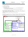
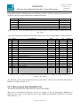
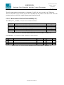
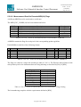
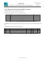
1
AMORGOS
Software User Manual & Interface Control Document
PO-ID-ACR-GS-0003
Issue 3 rev. 0A
15/02/2007
The AMORGOS MERIS CFI
(Accurate MERIS Ortho-Rectified Geo-location
Operational Software)
Software User Manual & Interface Control Document
PO-ID-ACR-GS-0003
Issue: 3
revision: 0A
15 February 2007
Prepared:
Function
Name
Company
Engineer
L. Bourg
ACRI-ST
F. Etanchaud
ACRI-ST
Approved:
s/w Coordinator
F. Etanchaud
ACRI-ST
Released:
Project Manager
L. Bourg
ACRI-ST
Copyright © 2007 ACRI-ST
Signature
Date
15/02/2007
AMORGOS
Software User Manual & Interface Control Document
Copyright © 2007 ACRI-ST
PO-ID-ACR-GS-0003
Issue 3 rev. 0A
15/02/2007
AMORGOS
Software User Manual & Interface Control Document
PO-ID-ACR-GS-0003
Issue 3 rev. 0A
15/02/2007
Distribution
Name
Quantity
P. GORYL (ESA/ESRIN)
1
L. BOURG (ACRI-ST)
1
F. ETANCHAUD (ACRI-ST)
1
Change Record
Issue
Draft
1
1
2
Revision Date
0
1
0
24.05.2005
20.07.2005
10.11.2005
22.12.2005
Description
Approval
First issue
Updated for Amorgos 1.0
Updated for Amorgos 1.1
Updated for Amorgos 2.0
Granted
Granted
Granted
Granted
Introduction of the MER_FSG product
3
0
30.05.2006
Updated for Amorgos 3.0
Granted
Windows version, FR scenes processing
3
0A
15.02.2007
Access to GETASSE DEM files
updated from ESA information
Copyright © 2007 ACRI-ST
Granted
AMORGOS
Software User Manual & Interface Control Document
Copyright © 2007 ACRI-ST
PO-ID-ACR-GS-0003
Issue 3 rev. 0A
15/02/2007
AMORGOS
Software User Manual & Interface Control Document
PO-ID-ACR-GS-0003
Issue 3 rev. 0A
15/02/2007
Page i
Table of Contents:
1. PURPOSE ............................................................................................................................. 1
2. REFERENCES ..................................................................................................................... 1
3. OVERVIEW ......................................................................................................................... 2
4. OPERATING AMORGOS.................................................................................................. 3
4.1 WINDOWS ......................................................................................................................... 3
4.1.1 Installation ................................................................................................................ 3
4.1.2 Running Amorgos...................................................................................................... 6
4.1.2.1 Quick tour........................................................................................................... 7
4.1.2.2 Run parameter set............................................................................................... 8
4.1.2.3 Preferences ......................................................................................................... 9
4.2 LINUX.............................................................................................................................. 11
4.2.1 Perform the installation .......................................................................................... 11
4.2.2 System Requirements............................................................................................... 12
4.2.3 Command syntax ..................................................................................................... 13
4.2.4 Configuration file format and content..................................................................... 13
4.2.5 Run Configuration................................................................................................... 15
4.3 DETAILED INTERFACE ..................................................................................................... 16
4.3.1 Overview.................................................................................................................. 16
4.3.1.1 Where to get the ESA provided files................................................................ 16
4.3.2 Input files................................................................................................................. 17
4.3.3 Auxiliary files .......................................................................................................... 17
4.3.4 GetAsse30 DEM files .............................................................................................. 18
4.3.5 Output files .............................................................................................................. 18
4.3.6 Returned value......................................................................................................... 19
5. FILES FORMAT AND CONTENT ................................................................................. 20
5.1 MERIS PIXELS POINTING VECTOR FILES........................................................................ 20
5.2 MER_FSO_1P................................................................................................................ 21
5.2.1 - Summary ............................................................................................................... 21
5.2.2 - Organization ......................................................................................................... 22
5.2.3 - Main Product Header ........................................................................................... 22
5.2.4 - Specific Product Header ....................................................................................... 22
5.2.5 - Annotation Data Set - Summary Quality .............................................................. 28
5.2.6 - Global Annotation Data Set - Scaling Factors ..................................................... 28
5.2.7 - Annotation Data Set - Tie Points Location & corresp. Aux. Data ....................... 28
5.2.8 - Measurement Data Sets MDS(1-16) ..................................................................... 29
5.2.8.1 - Measurement Data Set Records MDS(1-15) ................................................. 30
5.2.8.2 - Measurement Data Set Records MDS(16) Flags ........................................... 31
5.2.8.3 - Measurement Data Set Records MDS(17) Longitude ................................... 32
5.2.8.4 - Measurement Data Set Records MDS(18) Latitude ...................................... 33
5.2.8.5 - Measurement Data Set Records MDS(18) Altitude....................................... 34
5.3 MER_FSG_1P................................................................................................................ 35
5.3.1 - Summary ............................................................................................................... 35
5.3.2 - Organization ......................................................................................................... 36
Copyright © 2007 ACRI-ST
AMORGOS
Software User Manual & Interface Control Document
PO-ID-ACR-GS-0003
Issue 3 rev. 0A
15/02/2007
Page ii
5.3.3 - Main Product Header ........................................................................................... 36
5.3.4 - Specific Product Header ....................................................................................... 36
5.3.5 - Annotation Data Set - Summary Quality .............................................................. 42
5.3.6 - Global Annotation Data Set - Scaling Factors ..................................................... 42
5.3.7 - Annotation Data Set - Tie Points Location & corresp. Aux. Data ....................... 42
5.3.8 - Measurement Data Sets MDS(1-16) ..................................................................... 43
5.3.8.1 - Measurement Data Set Records MDS(1-15) ................................................. 44
5.3.8.2 - Measurement Data Set Records MDS(16) Flags ........................................... 45
5.3.8.3 - Measurement Data Set Records MDS(17) Longitude ................................... 46
5.3.8.4 - Measurement Data Set Records MDS(18) Latitude ...................................... 47
5.3.8.5 - Measurement Data Set Records MDS(18) Altitude....................................... 48
5.4 MER_FRG_1P ............................................................................................................... 49
5.4.1 - Summary ............................................................................................................... 49
5.4.2 - Organization ......................................................................................................... 50
5.4.3 - Main Product Header ........................................................................................... 50
5.4.4 - Specific Product Header ....................................................................................... 50
5.4.5 - Annotation Data Set - Summary Quality .............................................................. 56
5.4.6 - Global Annotation Data Set - Scaling Factors ..................................................... 56
5.4.7 - Annotation Data Set - Tie Points Location & corresp. Aux. Data ....................... 56
5.4.8 - Measurement Data Sets MDS(1-16) ..................................................................... 57
5.4.8.1 - Measurement Data Set Records MDS(1-15) ................................................. 58
5.4.8.2 - Measurement Data Set Records MDS(16) Flags ........................................... 59
5.4.8.3 - Measurement Data Set Records MDS(17) Longitude ................................... 60
5.4.8.4 - Measurement Data Set Records MDS(18) Latitude ...................................... 61
5.4.8.5 - Measurement Data Set Records MDS(18) Altitude....................................... 62
5.5 STATUS AND ERROR LOG FILES ...................................................................................... 63
5.5.1 Informational messages........................................................................................... 63
5.5.2 Error messages........................................................................................................ 64
5.5.2.1 WARN messages.............................................................................................. 64
5.5.2.2 ERROR messages ............................................................................................ 65
5.6 OPTIONAL TIFF OUTPUT FILES ........................................................................................ 67
6. PERFORMANCES ............................................................................................................ 68
Copyright © 2007 ACRI-ST
AMORGOS
Software User Manual & Interface Control Document
PO-ID-ACR-GS-0003
Issue 3 rev. 0A
15/02/2007
Page 1 on 74
1. Purpose
The purpose of the AMORGOS tool is to generate accurate geo-location information – longitude,
latitude, altitude – for each MERIS pixel,. starting from a MERIS Full Resolution product: either a
Full Swath or a standard half-swath Scene product. The quarter-swath product is not managed.
If the input product is a Full Swath one, the current version accepts two modes. The first one
preserves the organisation of the input product, namely the Level 1b product grid, it is referred to as
the FSG (full swath geo-corrected) mode and generates a MER_FSG_1P product. The second one
generate results re-organised in the instrument geometry, it is referred to as the FSO (full swath
ortho-geolocated) mode and generates a MER_FSO_1P product.
The FSO mode first restores radiance samples and accompanying flags into Instrument Geometry,
un-doing the spatial re-sampling of the Level1 processing, and computes accurate ortho-rectified
geo-location using MERIS detectors individual pointing vectors, a High Resolution DEM and
accurate spacecraft Orbit and Attitude files.
The FSG mode essentially skips the Instrument Geometry restoration step and computes the same
geo-location information for each MERIS detector and each acquisition time but it affects these
values to the corresponding MERIS L1B product pixels. It must be noted here that since the MERIS
product grid is filled by a nearest neighbour method from the Instrument Acquisition grid with a
slight spatial over-sampling, the same instrument sample can be found several times in the same
Level 1b product (it is then identified as a DUPLICATE pixel within the Level 1b product flags).
Since the additional geo-location information of the MER_FSG_1P product is linked to the source
Instrument sample, it will be duplicated the same way than the radiance information.
Ortho-rectified geo-location must be understood as the computation of the intersection of a given
sample line of sight with the Earth surface (as represented by the Digital Elevation Model) rather
than with the reference ellipsoid as in Level 1b. However, it must be noted that image geometry is
either the Instrument one (FSO mode) or the Level 1b one (FSG mode) and thus the output product
is not ortho-rectified stricto sensu.
2. References
RD1
RD2
RD3
RD4
PO-TN-MEL-GS-003
TBD
PO-RS-MDA-GS-2009
PO-IS-GMV-GS-0561
RD5
PO-IS-DMS-GS-0557
RD6
PO-IS-DMSGS-0559
MERIS Input/Output Data Definition Format
AMORGOS – Algorithm document
ENVISAT Product Specification
Envisat-1 Mission CFI Software -. Mission Conventions
Document
Envisat-1 Mission CFI Software - PPF_LIB Software User
Manual. PO-IS-DMS-GS-0557
Envisat-1 Mission CFI Software - PPF_POINTING Software
User Manual
Copyright © 2007 ACRI-ST
AMORGOS
Software User Manual & Interface Control Document
PO-ID-ACR-GS-0003
Issue 3 rev. 0A
15/02/2007
Page 2 on 74
3. Overview
AMORGOS is run once for every MER_FRS_1P or MER_FR__1P file and generates the
corresponding MER_FSO_1P, MER_FSG_1P or MER_FRG_1P file. Identification of the source
Instrument sample (defined by a detector index and an acquisition time), and if required the reconstruction of the instrument projection, is done using MER_FRS_1P internal data, the so-called
MERIS detector index data set, and some additional MERIS Level 1B auxiliary data, the FR frame
offsets, extracted from the appropriate MER_INS_AX file. For each MERIS sample, an orthogeolocation algorithm computes the first intersection between the pixel’s line of sight and the Earth
surface, represented by interpolation of the GetAsse30 high resolution Digital Elevation Model
(DEM) cells elevations on top of the reference ellipsoid. Line of sight is determined using its
pointing vector expressed relative to the satellite, the satellite location and attitude, that are in turn
determined from appropriate Orbit and Attitude files using the appropriate CFI routines. Location of
the intersection is expressed as longitude, geodetic latitude and geodetic altitude.
The principle of the computation described above is illustrated on the following figure (please note
that the figure does not show realistic observation conditions):
satellite
Surface
(GetAsse30 DEM)
Ellipsoid
(WGS 84)
Pixel line-of-sight
P1 (AMORGOS
geolocation)
h
d
Copyright © 2007 ACRI-ST
P0 (MERIS standard
products geoloc ation)
AMORGOS
Software User Manual & Interface Control Document
PO-ID-ACR-GS-0003
Issue 3 rev. 0A
15/02/2007
Page 3 on 74
4. Operating AMORGOS
The interface between AMORGOS and its hosting and operating facility is based on input, auxiliary
and output data files. Auxiliary files are further split amongst instrument related on one hand and
Digital Elevation Model files on the other hand.
The way to specify the various file paths to the software depends on the hosting platform: the
Windows version includes a Graphical User Interface while the Linux version, more oriented
toward mass processing in batch mode, uses a configuration file.
4.1 Windows
4.1.1 Installation
The installation kit for Windows (Microsoft Windows 2000 or higher) is on the form of an
automatic installer. After download, you just have to double-click on Amorgos30_Installer.exe and
follow the instructions.
You do not need to install any other software.
Note: it is highly recommended to install Amorgos as administrator! On most system configuration,
if you do not have administrator privileges when installing Amorgos, the installer will fail to create
the desktop shortcut (Amorgos) and the entry in the program launcher (program group
amorgos_interface, application Amorgos). However, if you , if you install amorgos as
unprivileged user but have write permissions on the installation directory, all software components
will be installed correctly. To create a desktop shortcut, go to the installation directory, right-click
on amorgos_interface.exe and select send to and desktop. To create an entry point in
the program launch menu, go to the Start Menu directory corresponding to your own account,
create there a new directory named e.g. amorgos_interface, and copy there a shortcut to
amorgos_interface.exe that you can rename e.g. Amorgos
Amorgos installation complies with standard Windows software installation, mainly :
Copyright © 2007 ACRI-ST
AMORGOS
Software User Manual & Interface Control Document
- where to install :
- which components to install :
complete installation (recommended):
Copyright © 2007 ACRI-ST
PO-ID-ACR-GS-0003
Issue 3 rev. 0A
15/02/2007
Page 4 on 74
AMORGOS
Software User Manual & Interface Control Document
PO-ID-ACR-GS-0003
Issue 3 rev. 0A
15/02/2007
Page 5 on 74
or customized one:
Note: command line processor and mandatory auxiliary data compose the minimal component set.
Copyright © 2007 ACRI-ST
AMORGOS
Software User Manual & Interface Control Document
PO-ID-ACR-GS-0003
Issue 3 rev. 0A
15/02/2007
Page 6 on 74
4.1.2 Running Amorgos
To launch Amorgos, you can:
• Either double-click on amorgos_interface.exe file in the installation directory
• Or use the shortcut icon on the desktop
• Or use the amorgos_interface\Amorgos entry point in the Launch Program menu
The set of parameters required by an Amorgos run is defined through a Graphical Interface. It is
described step by step in the following sections.
Amorgos is delivered with a complete Test Data Set, in order to allow to check installation. It
includes the DEM tiles necessary to run the test bun only those ones.
See section
The general data and control flow of an Amorgos run on Windows is depicted in the next figure.
The figure also highlights what shall be set through the preference menu or through the Run
Parameters menu.
Graphical Interface :
control flow
run parameters and
file paths settings
run command
data flow
MERIS CFI
AMORGOS
Auxiliary Data
directory
Pointing vectors files
product description files
MER_INS_AX
AUX_ATT_AX
DEM directory
GetasseDEM tiles
Preferences Settings
MER_FRx_1P
AUX_FRA_AX
DOR_VOR_AX and/or
DOR_POR_AX and/or
AUX_FRO_AX
Output directory
MER_FSO_1P or
MER_FSG_1P or
MER_FRG_1P
tiff files (optional)
log file
Run Parameters Settings
Note: ENVISAT files names used in the above figure are generic names, it does not imply that this
reflect the actual file names of a given run.
Copyright © 2007 ACRI-ST
AMORGOS
Software User Manual & Interface Control Document
PO-ID-ACR-GS-0003
Issue 3 rev. 0A
15/02/2007
Page 7 on 74
Amorgos will ask at first run for the location of the Getasse30 digital elevation model. Without this
mandatory information, Amorgos will not process any data. In order to limit disk usage, the tiles set
can be incomplete. If Amorgos cannot find a tile while processing, then it stops in error giving the
name of the missing tile in the status file. So the user can add the needed tile, process again, and
step by step complete the job.
4.1.2.1 Quick tour
This section explains how to launch the test data set in three mouse clicks.
- in the File menu, the <InstallationDirectory>\test\test.ini run file can be selected. Run parameter
fields are updated, and start button becomes enabled and green.
Copyright © 2007 ACRI-ST
AMORGOS
Software User Manual & Interface Control Document
PO-ID-ACR-GS-0003
Issue 3 rev. 0A
15/02/2007
Page 8 on 74
- The Start button can be pushed. it then becomes red. Progress bar and estimated remaining time
appear in the message bar. After a few seconds, process completes, and status file can be visualized.
4.1.2.2 Run parameter set
An Amorgos run needs the following parameter set :
1. the input product: Meris full swath (MER_FRS_1P) or full resolution scene
(MER_FR__1P) level 1 product to process
2. the processing window: frame interval to process [first frame, last frame] (see Important
Note below)
3. the satellite navigation file: providing accurate ENVISAT navigation along the orbit
corresponding to the input level 1 product
4. the satellite attitude file: providing accurate information on ENVISAT attitude (i.e.
orientation in space) along the orbit corresponding to the input level 1 product. This is the
only optional parameter. If not specified, processor will use the nominal attitude model.
WARNING: this may result in degraded geo-location accuracy.
5. the output directory: where the output files will be generated
6. TIFF format output files selection switch: the 15 radiances and the 3 geo-location data
sets (longitude, latitude and altitude) can also be generated in tiff image file format, allowing
easy visualization or loading in off-the-shelf software. Note: the geo-location data are stored
on 32 bits integers, which are not accepted by all visualisation softwares.
Copyright © 2007 ACRI-ST
AMORGOS
Software User Manual & Interface Control Document
PO-ID-ACR-GS-0003
Issue 3 rev. 0A
15/02/2007
Page 9 on 74
7. spatial re-sampling reversal switch: if the input product is a Full Swath one, spatial resampling can be reversed to restore data in instrument geometry (generation of a
MER_FSO_1P instead of MER_FSG_1P)
Please refer to section 4.3 for the detailed description of the input files (items 1, 3 & 4 in the above
list).
Important Note: the following rules apply to the output products time limits:
1.
The output product size is limited due to Operating System constraints, as a consequence,
the total number of frames processed will NEVER exceed 10305 for the FSG product and
12865 for the FSO product (the latter being the specified maximum size of the input FRS
product). As a consequence, a run in FSG mode may result in a partial processing of
the input file, even if complete processing was required. Output time limits (expressed in
frame units) are always reported in the status log file to allow systematic checks (see section
5.4 for message format).
2.
The output product shall follow the granule rule, i.e. the total number of frames shall cover
the extent of the total number of Tie Frames (Annotation records, see RD 1 for details) to
ensure that any measurement frame time is within the interval defined by two consecutive
annotation record times. If the [first frame, last frame] parameters provided do
not respect these rules, first frame will be forced to the closest earlier Annotation
frame (if required) and the actual number of processed frames will be forced to a value that
completes the granule of the requested last frame (to the limit expressed by rule 1, see
above).
3.
Whenever the software has to modify the product time limits for any of the above reasons,
an informational message will be provided in the status log file (see section 5.4 for message
format).
The whole parameter set can be saved and later restored via the File/Save, Save as and Open menu
items. The three last edited parameter sets can be loaded directly from the list in File menu. Edition
of some parameters is always possible after a Parameter Set file has been restored.
Once all parameters have been specified and are valid, the start button is enabled, its colour then
turns to light green, and data can be processed.
4.1.2.3 Preferences
Amorgos has a few configuration parameters :
1. Digital Elevation Model location: the path to directory that contains the Getasse30 tiles.
2. auxiliary data location: the path to the directory that contains auxiliary data, part of the
Amorgos software package,
3. path to command line processor binary file.
These parameters can be edited in the File/Preference menu item. If configuration is valid, Ok
button is enabled. Once pressed, parameters becomes the current configuration.
Default - installation - configuration can be later restored via "Default values" button.
Copyright © 2007 ACRI-ST
AMORGOS
Software User Manual & Interface Control Document
PO-ID-ACR-GS-0003
Issue 3 rev. 0A
15/02/2007
Page 10 on 74
The last parameter is an interface parameter : interface language, either English or French.
Copyright © 2007 ACRI-ST
AMORGOS
Software User Manual & Interface Control Document
PO-ID-ACR-GS-0003
Issue 3 rev. 0A
15/02/2007
Page 11 on 74
4.2 Linux
In the Linux version, Amorgos is run via a shell script, part of the delivery.
The unique entry point to the shell script is the path to a configuration file. This configuration file is
used to specify actual paths to the input, output, auxiliary and DEM directories where AMORGOS
will, respectively, expect the input files, generate the output files (including the log files) and read
auxiliary files.
control flow
Run parameters:
path to configuration file
data flow
MERIS CFI
AMORGOS
Run Directory
InputDir
MER_FRX_1P
AUX_FRA_AX
DOR_VOR_AX and/or
DOR_POR_AX and/or
AUX_FRO_AX
AuxDir
DEMDir
Pointing vectors files GetasseDEM tiles
product description files
MER_INS_AX*.N1
AUX_ATT_AX
OutputDir
MER_FSO_1P or
MER_FSG_1P
tiff files (optional)
log file
AMORGOS data and control flow
4.2.1 Perform the installation
CONVENTION:
In the following text, a symbol like $AMORGOS_INSTALL is used to describe your AMORGOS
installation directory from the standpoint of this document. In the following instructions, you should
replace it by its appropriate value. This convention is used with several different directories.
1. Go into the wanted directory for restoring installation files.
Type the following command :
cd $AMORGOS_INSTALL
Note that distribution files need about 300 MB, so make sure to have such free disk space
before starting the restoration.
2. Restore the distribution files.
Copyright © 2007 ACRI-ST
PO-ID-ACR-GS-0003
Issue 3 rev. 0A
15/02/2007
Page 12 on 74
AMORGOS
Software User Manual & Interface Control Document
Type the following command :
tar -xvf [<path name>/]AMORGOS.tar
where <path name> (optional) is the path to the Amorgos distribution tar file.
example :
> tar -xvf /dvdrom/dvdrom0/AMORGOS.tar
This operation restores all the distribution files as outlined on the figure below:
AMORGOS EXECUTABLE DISTRIBUTION TREE STRUCTURE
legend :
existing directory
AMORGOS Executable
Distribution tar file
created directory
$AMORGOS_INSTALL
created files
AMORGOS.x.x
bin
executable,
script and test
configuration
file
AuxDir
auxiliary files
test
DEMDir
test input files
sample DEM
tiles
3. Perform the test run.
The installation kit includes a full set of files to allow you to perform a test run.
For this, the simplest way is to go into the bin directory and type the following command:
./amorgos.sh ./test.ini
The result files will be created in the test directory.
You can monitor the run progress (from another command window) by the command:
tail -f ../test/status.txt (assuming you still are in the bin directory)
4.2.2 System Requirements
AMORGOS is composed of a C executable program operated through a UNIX shell script. It is
intended to be run on a LINUX station with kernel 2.4.
The AMORGOS C executable needs access to the following system libraries:
Copyright © 2007 ACRI-ST
AMORGOS
Software User Manual & Interface Control Document
PO-ID-ACR-GS-0003
Issue 3 rev. 0A
15/02/2007
Page 13 on 74
libm.so.6 =>
/lib/i686/libm.so.6
libc.so.6 =>
/lib/i686/libc.so.6
/lib/ld-linux.so.2 => /lib/ld-linux.so.2
4.2.3 Command syntax
AMORGOS shall always be operated through its associated UNIX shell script amorgos.sh.
Both the shell script and the C executable AMORGOS shall be located in the same directory.
Syntax:
exec_path/amorgos.sh configuration_file_name
where:
•
exec_path is a valid UNIX path, either absolute or relative, to the directory where
./amorgos.sh,
all
the
executable
files
can
be
found,
e.g.
/file_system/dir/amorgos.sh, …,
•
configuration_file_name is a valid UNIX path name to the AMORGOS
configuration file, either absolute or relative to the current directory (i.e. where the
command is issued). The user issuing the command shall have read permissions for
the configuration file.
4.2.4 Configuration file format and content
The configuration file is under responsibility of the user. It allows the user to specify the location of
the input, auxiliary, DEM and output directories. It is an ASCII text file, formatted as a list of
keywords followed by character strings enclosed in double quotes and a new line character.
Keywords must start on the first column of a line and must be followed by a "=" sign. Character
strings or numerical shall follow immediately the "=" sign. There are no blank spaces. Keywords
and associated values must be written on one single line. Character strings cannot exceed 128
characters. Any line starting with the '#' symbol is considered as a comment line and ignored;
empty lines are used as separators and are ignored as well.
The directory paths fields are mandatory, as bearing essential information for the main program run.
The configuration fields, CONFIG_FILE and DATE, as well as the option switches, FSO_MODE,
FIRST_FRAME, FRAME_NUMBER and TIFF_SWITCH, are not mandatory: the first two have
been included to ease user’s configuration management but are not used internally, and the last ones
are set to the default values specified below if not provided.
The requested fields are:
Copyright © 2007 ACRI-ST
AMORGOS
Software User Manual & Interface Control Document
Field Format
Description
CONFIG_FILE=<filepath>
DATE=<UTC date>
<empty>
NAME_INPUT_DIR=<directory>
NAME_AUX_DIR=<directory>
NAME_DEM_DIR=<directory>
NAME_OUTPUT_DIR=<directory>
<empty>
FSO_MODE=<0 or 1>
Name of the configuration file
File creation date
Separator
Identification of the input directory
Identification of the auxiliary directory
Identification of the auxiliary directory
Identification of the output directory
Separator
Processing mode switch: 0 = FSG mode (default),
1= FSO mode
Index of the frame (input image line) at which
processing shall start (numbering starts at 1).
Defaults to 1 if not provided.
Total number of frames to process. Defaults to
number of frames in the input product if not
provided.
Switch enabling generation of optional output
TIFF files
FIRST_FRAME=<n>
FRAME_NUMBER=<m>
TIFF_SWITCH=<0 or 1>
PO-ID-ACR-GS-0003
Issue 3 rev. 0A
15/02/2007
Page 14 on 74
Comment
mandatory field
mandatory field
mandatory field
mandatory field
See note below.
See note below.
1=generation enabled
Where:
<filepath>:
<directory>:
<UTC date>:
n or m
valid Unix filename including its absolute or relative path. Up to 128
characters can be specified. If relative, path must be expressed with respect to
where the amorgos.sh command is issued.
valid Unix directory name. Up to 64 characters can be specified.
UTC date in ENVISAT-1 external format as described in RD3.
Integer numbers greater or equal to 1, maximum values following the rules
detailed below
Important Note: the following rules apply to the output products time limits:
1.
The output product size is limited due to Operating System constraints, as a consequence,
the total number of frames processed will NEVER exceed 10305 for the FSG product and
12865 for the FSO product (the latter being the specified maximum size of the input FRS
product). As a consequence, a run in FSG mode may result in a partial processing of
the input file, even if complete processing was required. Output time limits (expressed in
frame units) are always reported in the status log file to allow systematic checks (see section
5.4 for message format).
2.
The output product shall follow the granule rule, i.e. the total number of frames shall cover
the extent of the total number of Tie Frames (Annotation records, see RD 1 for details) to
ensure that any measurement frame time is within the interval defined by two consecutive
annotation record times. If the FIRST_FRAME and / or the FRAME_NUMBER options are
provided and do not respect these rules, FIRST_FRAME will be forced to the closest earlier
Annotation frame (if required) and the actual number of processed frames will be forced to a
value that completes the that completes the granule of the requested last frame (to the limit
expressed by rule 1, see above).
3.
Whenever the software has to modify the product time limits for any of the above reasons,
an informational message will be provided in the status log file (see section 5.4 for message
format).
Copyright © 2007 ACRI-ST
AMORGOS
Software User Manual & Interface Control Document
PO-ID-ACR-GS-0003
Issue 3 rev. 0A
15/02/2007
Page 15 on 74
Examples:
CONFIG_FILE="/ocean/data/AMORGOS/test_Averaging/AMORGOS.config"
DATE="12-DEC-2005 18:16:00.000000"
NAME_INPUT_DIR="/Disk1/data/AMORGOS/test_Adriatic/input"
NAME_AUX_DIR="/Disk1/data/AMORGOS/Auxiliary”
NAME_DEM_DIR="/Disk2/Ancillary/GETASSE"
NAME_OUTPUT_DIR="/Disk1/data/AMORGOS/test_Adriatic/output”
TIFF_SWITH=0
CONFIG_FILE="/Disk1/data/AMORGOS/test_Adriatic/AMORGOS.config"
DATE="12-DEC-2005 18:16:00.000000"
NAME_INPUT_DIR="/Disk1/data/AMORGOS/test_Adriatic/input"
NAME_AUX_DIR="/Disk1/data/AMORGOS/Auxiliary”
NAME_DEM_DIR="/Disk2/Ancillary/GETASSE"
NAME_OUTPUT_DIR="/Disk1/data/AMORGOS/test_Adriatic/output”
FSO_MODE=0
FIRST_FRAME=10305
FRAME_NUMBER=2561
TIFF_SWITCH=1
4.2.5 Run Configuration
Once the configuration is properly set to define all the run parameters, the following set of files
must be available to the software:
In the Input Directory:
All the files mentioned in section 0, respecting naming conventions specified for Linux by either
physical copy or link.
In the Auxiliary Directory:
All the files mentioned in section 4.3.3, respecting naming conventions specified for Linux by
either physical copy or link.
In the DEM Directory:
All the Getasse30 tiles necessary to cover the area delineated by the MERIS Level 1b product to be
processed. File names must be the original Getasse30 distribution ones.
Copyright © 2007 ACRI-ST
AMORGOS
Software User Manual & Interface Control Document
PO-ID-ACR-GS-0003
Issue 3 rev. 0A
15/02/2007
Page 16 on 74
4.3 Detailed Interface
4.3.1 Overview
Distinction is made between input files, specific to a given AMORGOS run, and auxiliary ones,
common to all runs, or at least unfrequently modified. In addition, the DEM files are expected in a
different directory, because they are assumed user provided and their total size makes them
somewhat difficult to handle.
AMORGOS expects the user to define the path to each of the input files - listed in section 4.3.2
below. Under Linux, they are all gathered in the input directory, the path of which is specified in
the configuration file ; under Windows, they are individually selected interactively.
AMORGOS will create all the output files - listed in section 4.3.3 below - in the output directory,
the path of which is specified in the configuration file (Linux) or interactively (Windows).
AMORGOS also needs to access auxiliary files, delivered with the software, in the auxiliary
directory, the path of which is specified in the configuration file (Linux) or interactively
(Windows), and, finally, access to the GETASSE Digital Elevation Model tiles, assumed to be
located in a single directory, the DEM directory, the path of which is also specified in the
configuration file (Linux) or interactively (Windows).
AMORGOS shall have write and read rights for the output directory and its content. Read right is
sufficient for all other directories and files.
It should be noted that the input, output, auxiliary and DEM directories can be identical providing
that the above rules are satisfied.
4.3.1.1 Where to get the ESA provided files
The Amorgos distribution provides only the Amorgos auxiliary files and a test data set. To proceed
to other runs you may need:
Another MERIS full resolution product. If you are interested by Amorgos, we assume that you
know how to order MERIS data products, however more details can be found at:
http://earth.esa.int/pcs/envisat/meris/documentation/Access_to_MERIS_data.pdf
Corresponding Orbit and Attitude files. They can be obtained from ESA upon request to
[email protected].
Complementary GETASSE30 files. The whole distribution can downloaded from:
http://earth.esa.int/services/amorgos/download/getasse/ (288 files of 12 :Mb each, or 3.48 Gb as a
whole). Optionally, the full distribution can be obtained on DVD upon request to [email protected].
Copyright © 2007 ACRI-ST
PO-ID-ACR-GS-0003
Issue 3 rev. 0A
15/02/2007
Page 17 on 74
AMORGOS
Software User Manual & Interface Control Document
4.3.2 Input files
File Name
File description
Descr. §
Origin
unconstrained
Configuration file (Linux only)
4.2.3
User defined
MER_FRX_1P (Linux),
MERIS full resolution full swath or full See RD1
ESA
unconstrained (Windows) resolution scene Level 1B product
provided
See RD3
ESA
DOR_VOR_AX
and/or, ENVISAT Orbit files.
provided
DOR_POR_AX
and/or, Note: the software selects the ‘best
quality’ file among the actually available
AUX_FRO_AX (Linux)
unconstrained (Windows) files. Only one of them is mandatory.
AUX_FRA_AX(Linux),
Restituted Attitude file
See RD3
ESA
unconstrained (Windows)
provided
Note: (Linux) generic name of the input Level 1b product has been set to MER_FRX_1P to
accommodate for the ability of Amorgos to process MER_FR__1P and MER_FRS_1P products.
WARNING: Input files are user provided and under user’s responsibility. In particular, the
user must ensure, to properly process a given MER_FRS_1P or MER_FR__1P:
1. Amorgos do not process all kinds of MER_FR__1P products. They exist in two sizes: the
scene product, also referred to as half-swath, and the imagette, or quarter-swath, product.
The former has a spatial extent of 2241 by 2241 pixels and the latter 1121 by 1121.
AMORGOS can only process half-swath scenes MER_FR__1P.
2. to provide the appropriate AUX_FRA_AX file, that is a file who’s content must cover the
time span of the MERIS FR product to be processed plus TBD seconds before and TBD
seconds after.
3. to provide at least one appropriate orbit file, among DOR_VOR_AX DOR_POR_AX and
AUX_FRO_AX, with a content that must cover the time span of the MER_FRS_1P product
to be processed plus 4 minutes before and 4 minutes after.
4. that all files submitted to processing are properly named according to the File Name column
of the above Table (Linux).
4.3.3 Auxiliary files
File Name
File description
Descr. §
Origin
Set of MERIS Instrument Data Products See RD1 ACRI-ST
provided
(Amorgos will automatically select the one
mentioned in the MER_FRX_1P metadata)
ACRI-ST
Pointing_at_Pixels_FR_SaCS.m? Pointing vector files. The ? sign stands for 5.1
provided
any number within 1, 5 and identifies the
corresponding MERIS camera module.
See RD3 ACRI-ST
AUX_ATT_AX
Envisat Predicted Attitude file
provided
Note: if the appropriate AUX_FRA_AX is
provided, this file will not be used.
index_?.txa,
MERIS products description files. The ? N/A
ACRI-ST
database.db
sign stands for a one-digit alpha-numeric
provided
MER_INS_AX*.N1
Copyright © 2007 ACRI-ST
AMORGOS
Software User Manual & Interface Control Document
PO-ID-ACR-GS-0003
Issue 3 rev. 0A
15/02/2007
Page 18 on 74
character identifying a given product file.
All the files described above are provided with the Amorgos software.
It is kindly suggested to the user to leave them unchanged.
4.3.4 GetAsse30 DEM files
File Name
xxVyyyH.GETASSE30
File description
Descr. §
Set of Digital Elevation Model tiles, each N/A
one covering an area of 15 degrees of
longitude by 15 degrees of latitude
(Amorgos will automatically determine
which ones are necessary for a given
processing and access only those).
xxVyyyH corresponds to the latitude and
longitude of the South-West corner of the
covered area: xx (resp. yyy) is the latitude
(resp. longitude) value, by steps of 15
degrees, V (resp. H) identifies the North or
South (resp. West or East) hemisphere.
xx ranges 0 to 65 if V=N, 15 to 90 if V=S
yyy 15 to 180 if H=W, 0 to 165 if H=E
Origin
ESA
provided
4.3.5 Output files
File Name
MER_FSO_1P, MER_FSG_1P
MER_FRG_1P
status.txt, error.txt
radiance.?.tiff
File description
Descr. §
or Output file in PDS format
5.2 to
5.4
Status and error log files
5.5
Optional TIFF format output radiance files. ? 5.6
stands for the spectral band index, in [1,15]
flags.tiff
Optional TIFF format flags file
5.6
logitude.tiff, latitude.tiff, altitude.tiff Optional TIFF format geolocation data files 5.6
Important Note: AMORGOS will always generate the MER_FSO_1P (resp. MER_FSG_1P,
MER_FRG_1P) output file under its generic name “MER_FSO_1P” (resp. MER_FSG_1P,
MER_FRG_1P) , however, the PRODUCT field of its MPH is appropriately filled. It is the
responsibility of the user to rename the file accordingly. This renaming can be done easily by a
simple Unix command, e.g. in MER_FSG_1P case:
mv MER_FSG_1P `head -1 MER_FSG_1P | cut -d'=' -f2 | sed s/\"//g`
Execution of AMORGOS generates a status log file, and in some cases, an error log file, in the
output directory, named status.txt and errors.txt respectively. The status log file is
intended to be the recipient of all the messages generated during an AMORGOS run, either
Copyright © 2007 ACRI-ST
AMORGOS
Software User Manual & Interface Control Document
PO-ID-ACR-GS-0003
Issue 3 rev. 0A
15/02/2007
Page 19 on 74
informational or reporting an error or exceptional event. The error log file is intended to be the
recipient of all the messages reporting an exception or an unexpected event during an AMORGOS
run. It allows an immediate verification of the run status.
There are two levels of errors occurring in AMORGOS: warnings and fatal errors. Execution
continues normally after a warning is sent but a fatal error causes AMORGOS to stop immediately
after it is raised.
4.3.6 Returned value
The AMORGOS associated shell script amorgos.sh returns 0 if successful, and a value different
from 0 if an error occurred.
Copyright © 2007 ACRI-ST
AMORGOS
Software User Manual & Interface Control Document
PO-ID-ACR-GS-0003
Issue 3 rev. 0A
15/02/2007
Page 20 on 74
5. Files Format and Content
5.1 MERIS Pixels Pointing Vector Files
name :
Pointing_at_Pixels_FR_SaCS.m%
content :
Pointing vectors projection on X and Y axis of SaCS for each FR column
data origin : MERIS Calibration CFI
type :
all ASCII file
format :
header :
Line description
C format
arguments
keyword :
#FD="%s" "Interpolated pointing directional cosines Ux and
Uy in SaCS, FR pixels"
file creation date
#CD="%s" date of file creation/update in UTC
identifiers :
#ID=%d, 1, module index
m=%d
number of dimensions : #ND=%d 1
number of data per line #NC=%d 3
dimension1 :
#D1=%d
number of spatial positions in data (740)
band set description
#BS=%d, number of bands and for each, first CCD row index
%d-%d, ..., and width in CCD rows ( ... stands for all the missing format
descriptors ", %d-%d" needed to match the actual number of bands)
%d-%d
format mnemonic :
#FM="%s" "k, Ux, Uy"
read format
#RF="%s" "%d %le %le"
data : each line is composed of a set of three values
symbol : k
Ux
Uy
meaning : CCD column index X projection Y projection
format
%d
%.15e
%.15e
unit
dl
dl
dl
Copyright © 2007 ACRI-ST
AMORGOS
Software User Manual & Interface Control Document
PO-ID-ACR-GS-0003
Issue 3 rev. 0A
15/02/2007
Page 21 on 74
5.2 MER_FSO_1P
5.2.1 - Summary
The Level 1b Full Swath Full Resolution Ortho-geolocated Product, hereafter referred to as Level
1b FSO, is summarised below:
Name
Identifier
Product Level
Description
Coverage
Packaging
Unit
Range
Sampling
Resolution
Accuracy
Geo-location
requirements
Format
Annotated data
Frequency
Size
Level 1b full resolution
MER_FSO_1P
1b
Radiance measurements at top of atmosphere for the 15
MERIS bands, in instrument projection, calibrated,
radiometrically
corrected,
geo-located
with
orthorectification at pixel level, annotated with PCD,
calibration data, classification flags, environment
parameters
Regional
Segment (see definition in [RD1] §2.4, here limited to a
maximum duration of 9mn 26s or 12865 lines)
10-3 W.m-2.sr-1.nm-1
0..26 to 0..270 (band dependent)
spatial : 260 m across track at nadir and 290 m along
track.
spectral : MERIS bands (see [RD1] Table 3.2.1)
radiometric : NEDL (see [R-5] of [RD1])
spatial : MTF > 0.3 at Nyquist freq. ([R-5] of [RD1])
spectral : ≤ 2.5 nm ([R-5] of [RD1])
radiometric : ≤ 2% in 400-900 nm range ([R-5] of [RD1])
absolute geometric : 2000m (spec. in [R-5] of [RD1])
relative geometric : 1000m (spec. in [R-5] of [RD1])
Each
instrument
pixel
is
geo-located
with
orthorectification (i.e. accounting for the Earth surface
elevation as provided by a Digital Elevation Model).
• 16 bits/sample
• 3700 samples/record
• 19 records/line
• up to 12865 lines/MDS
• 1 GADS, 2 ADS & 19 MDS (15 for TOA LU, 1 for
flags, 3 for longitudes, latitudes and altitudes)
see below
Variable (upon Level 0 data availability and processing requests)
1818 Mbytes per product (max)
Table 4.3.2.1 - Level 1b Full Swath Ortho-geolocated Product - Summary
Copyright © 2007 ACRI-ST
AMORGOS
Software User Manual & Interface Control Document
PO-ID-ACR-GS-0003
Issue 3 rev. 0A
15/02/2007
Page 22 on 74
5.2.2 - Organization
The high-level breakdown of the Level 1-FSO product is described below:
Description
Level 1b FSO - MPH
Level 1b FSO - SPH
Level 1b FSO - Summary Quality ADS
Level 1b FSO - GADS Scaling Factors
Level 1b FSO - ADS Tie Points Location & Aux. Data
Level 1b FSO - MDS(1) TOA Radiance
Level 1b FSO - MDS(2) TOA Radiance
Level 1b FSO - MDS(3) TOA Radiance
Level 1b FSO - MDS(4) TOA Radiance
Level 1b FSO - MDS(5) TOA Radiance
Level 1b FSO - MDS(6) TOA Radiance
Level 1b FSO - MDS(7) TOA Radiance
Level 1b FSO - MDS(8) TOA Radiance
Level 1b FSO - MDS(9) TOA Radiance
Level 1b FSO - MDS(10) TOA Radiance
Level 1b FSO - MDS(11) TOA Radiance
Level 1b FSO - MDS(12) TOA Radiance
Level 1b FSO - MDS(13) TOA Radiance
Level 1b FSO - MDS(14) TOA Radiance
Level 1b FSO - MDS(15) TOA Radiance
Level 1b FSO - MDS(16) Flags
Level 1b FSO - MDS(17) Longitude
Level 1b FSO - MDS(16) Latitude
Level 1b FSO - MDS(16) Altitude
Product Size
Size
1247
10782
858
292
719726
95368245
95368245
95368245
95368245
95368245
95368245
95368245
95368245
95368245
95368245
95368245
95368245
95368245
95368245
95368245
47767745
190569245
190569245
95368245
!Erreur de
syntaxe, )
Table 4.3.2.2 - Level 1b Full Swath Ortho-geolocated Product - High-level breakdown
5.2.3 - Main Product Header
The format and the content of the Main Product Header shall be as specified in [RD3].
5.2.4 - Specific Product Header
The Specific Product Header format shall be as specified in [RD3].
The Data Set Descriptor format shall be as specified in [RD3].
The Level 1b Full Swath Ortho-geolocated Product Specific Product Header will be in ASCII
format and its content shall be as follows:
Copyright © 2007 ACRI-ST
AMORGOS
Software User Manual & Interface Control Document
N
1
Byte #
0
2
46
3
82
4
102
5
6
7
118
164
209
Description
Unit
keyword
SPH_DESCRIPTOR=
quotation mark (“)
SPH Descriptor
ASCII string describing the product.
quotation mark (“)
newline character
terminator
keyword
STRIPLINE_CONTINUITY_INDICATOR=
Value: 0= No stripline continuity, the product is a
complete segment
Other: Stripline Counter
newline character
terminator
keyword
SLICE_POSITION=
Value: +001 to NUM_SLICES
Default value if no stripline continuity = +001
newline character
terminator
keyword
NUM_SLICES=
Number of slices in this stripline Default value if no
continuity = +001
newline character
terminator
Product Time Information
keyword
FIRST_LINE_TIME=
quotation mark (“)
Azimuth time first line of product.
UTC
UTC Time of first range line in the MDS of this
product. UTC time format contained within
quotation marks.
quotation mark (“)
newline character
terminator
keyword
LAST_LINE_TIME=
quotation mark (“)
Azimuth time last line of product Time of last range
UTC
line in the MDS of this product. UTC time format
contained within quotation marks.
quotation mark (“)
newline character
terminator
Product Positioning Information
keyword
FIRST_FIRST_LAT=
Geodetic Latitude of the first sample of the first line 10 -6 degrees
A negative value denotes south latitude, a positive
value denotes North latitude
<10-6degN>
units
newline character
terminator
Copyright © 2007 ACRI-ST
PO-ID-ACR-GS-0003
Issue 3 rev. 0A
15/02/2007
Page 23 on 74
T
uc
uc
uc
D
15
1
28
# Bytes
15
1
28
uc
uc
uc
Ac
1
1
31
1
1
1
31
4
uc
uc
Ac
1
15
1
1
15
4
uc
uc
Ac
1
11
1
1
11
4
uc
1
1
uc
uc
uc
16
1
27
16
1
27
uc
uc
uc
uc
uc
1
1
15
1
27
1
1
15
1
27
uc
uc
1
1
1
1
uc
Al
16
1
16
11
uc
uc
10
1
10
1
AMORGOS
Software User Manual & Interface Control Document
8
9
10
11
247
286
322
359
12 396
13 434
14 471
15 509
FIRST_FIRST_LONG=
East geodetic longitude of the first sample of the first
line.Positive values East of Greenwich, negative
values west of Greenwich.
<10-6degE>
newline character
FIRST_MID_LAT=
Geodetic Latitude of the middle sample of the first
line A negative value denotes south latitude, a
positive value denotes North latitude
<10-6degN>
newline character
FIRST_MID_LONG=
East geodetic longitude of the middle sample of the
first line.Positive values East of Greenwich, negative
values west of Greenwich.
<10-6degE>
newline character
FIRST_LAST_LAT=
Geodetic Latitude of the last sample of the first line
A negative value denotes south latitude, a positive
value denotes North latitude
<10-6degN>
newline character
FIRST_LAST_LONG=
East geodetic longitude of the last sample of the first
line.Positive values East of Greenwich, negative
values west of Greenwich.
<10-6degE>
newline character
LAST_FIRST_LAT=
Geodetic Latitude of the first sample of the last line
A negative value denotes south latitude, a positive
value denotes North latitude
<10-6degN>
newline character
LAST_FIRST_LONG=
East geodetic longitude of the first sample of the last
line.Positive values East of Greenwich, negative
values west of Greenwich.
<10-6degE>
newline character
LAST_MID_LAT=
Geodetic Latitude of the middle sample of the last
line A negative value denotes south latitude, a
positive value denotes North latitude
<10-6degN>
newline character
Copyright © 2007 ACRI-ST
PO-ID-ACR-GS-0003
Issue 3 rev. 0A
15/02/2007
Page 24 on 74
keyword uc
10-6 degrees Al
17
1
17
11
units
terminator
keyword
10-6 degrees
uc
uc
uc
Al
10
1
14
1
10
1
14
11
units
terminator
keyword
10-6 degrees
uc
uc
uc
Al
10
1
15
1
10
1
15
11
units
terminator
keyword
10-6 degrees
uc
uc
uc
Al
10
1
15
1
10
1
15
11
units
terminator
keyword
10-6 degrees
uc
uc
uc
Al
10
1
16
1
10
1
16
11
units
terminator
keyword
10-6 degrees
uc
uc
uc
Al
10
1
15
1
10
1
15
11
units
terminator
keyword
10-6 degrees
uc
uc
uc
Al
10
1
16
1
10
1
16
11
units
terminator
keyword
10-6 degrees
uc
uc
uc
Al
10
1
13
1
10
1
13
11
units
uc
terminator uc
10
1
10
1
AMORGOS
Software User Manual & Interface Control Document
16 544
17 580
18 616
19 653
20 701
21 718
22 736
23 752
24 770
25 783
26 809
27 836
keyword uc
LAST_MID_LONG=
East geodetic longitude of the middle sample of the 10-6 degrees Al
last line.Positive values East of Greenwich, negative
values west of Greenwich.
<10-6degE>
units
uc
newline character
terminator uc
keyword uc
LAST_LAST_LAT=
Geodetic Latitude of the last sample of the last line A 10-6 degrees Al
negative value denotes south latitude, a positive
value denotes North latitude
<10-6degN>
units
uc
newline character
terminator uc
keyword uc
LAST_LAST_LONG=
East geodetic longitude of the last sample of the last 10-6 degrees Al
line.Positive values East of Greenwich, negative
values west of Greenwich.
<10-6degE>
units
uc
newline character
terminator uc
uc
Spare (blank characters)
newline character
terminator uc
Product Quality Information
keyword uc
TRANS_ERR_FLAG=
Set to 1 if number of transmission errors exceeds
uc
threshold. Set to 0 otherwise.
newline character
terminator uc
keyword uc
FORMAT_ERR_FLAG=
Set to 1 if number of format errors exceeds
uc
threshold. Set to 0 otherwise.
newline character
terminator uc
keyword uc
DATABASE_FLAG=
Flag set to 1 if the processing parameters data base
uc
contents does not match the packet header contents.
newline character
terminator uc
keyword uc
COARSE_ERR_FLAG=
Flag indicating coarse offsets are above threshold
uc
newline character
terminator uc
keyword uc
ECMWF_TYPE=
0 = forecast ECMWF data was used 1 = analysis
uc
ECMWF data was used
newline character
terminator uc
keyword uc
NUM_TRANS_ERR=
Number of transmission errors in the product
A1
newline character
terminator uc
keyword uc
NUM_FORMAT_ERR=
Number of format errors in the product
A1
newline character
terminator uc
keyword uc
TRANS_ERR_THRESH=
Threshold for setting TRANS_ERR_FLAG
%
Afl
<%>
units
uc
newline character
terminator uc
Copyright © 2007 ACRI-ST
PO-ID-ACR-GS-0003
Issue 3 rev. 0A
15/02/2007
Page 25 on 74
14
1
14
11
10
1
14
1
10
1
14
11
10
1
15
1
10
1
15
11
10
1
47
1
10
1
47
1
15
1
15
1
1
16
1
1
16
1
1
14
1
1
14
1
1
16
1
1
11
1
1
16
1
1
11
1
1
14
1
1
15
1
1
17
1
3
1
1
14
11
1
15
11
1
17
15
3
1
AMORGOS
Software User Manual & Interface Control Document
28 872
29 909
30 987
31 1002
32 1189
33 1198
34
1328
35
1340
36
1354
37
1392
38
1420
FORMAT_ERR_THRESH=
Threshold for setting FORMAT_ERR_FLAG
<%>
newline character
Spare (blank characters)
newline character
Additional Product Information
NUM_BANDS=
Number of bands in the product
newline character
BAND_WAVELEN=
List of up to 15 band central wavelengths of the
bands contained in this product. Unused values are
set to zero.
<10-5nm>
newline character
BANDWIDTH=
List of up to 15 bandwidths for the bands in the
product. The order of the list must match the
order of the central wavelengths entries in the
previous field. Unused values are set to zero. Each
entry is of the form Al. e.g., if only 13 bands were
included
in
the
product:
+10000+10000+10000+10000+10000+10000+1000
0+07500+02500+05000+12500+10000+12500+000
00+00000
<10-3nm>
newline character
INST_FOV=
Instantaneous Field of View
<10-6deg>
newline character
PROC_MODE=
Processor mode of operation 1 = Raw 0 = Full
Processing
newline character
OFFSET_COMP=
Offset Compensation 1=ON 0=OFF
newline character
LINE_TIME_INTERVAL=
Line spacing in time
<10-6s>
newline character
LINE_LENGTH=
Number of samples per output line
<samples>
newline character
LINES_PER_TIE_PT=
Number of lines between along track tie points
newline character
Copyright © 2007 ACRI-ST
PO-ID-ACR-GS-0003
Issue 3 rev. 0A
15/02/2007
Page 26 on 74
keyword
%
units
terminator
terminator
uc
Afl
uc
uc
uc
uc
18
1
3
1
77
1
18
15
3
1
77
1
keyword
terminator
keyword
10-3 nm
uc
Ac
uc
uc
Al
10
1
1
13
15
10
4
1
13
165
units
terminator
keyword
10-3 nm
uc
uc
uc
As
8
1
10
15
8
1
10
90
units
terminator
keyword
10-6 deg
units
terminator
keyword
flag
uc
uc
uc
Al
uc
uc
uc
uc
8
1
9
1
9
1
10
1
8
1
9
11
9
1
10
1
terminator
keyword
flag
terminator
keyword
(10-6) sec
units
terminator
keyword
samples
units
terminator
keyword
lines
terminator
uc
uc
uc
uc
uc
Al
uc
uc
uc
As
uc
uc
uc
Ac
uc
1
12
1
1
19
1
7
1
12
1
9
1
17
1
1
1
12
1
1
19
11
7
1
12
6
9
1
17
4
1
AMORGOS
Software User Manual & Interface Control Document
39
1442
40
1466
41
1500
42
1542
43
1822
44
2102
45
46
46
46
46
2382
6582
6582
6582
6582
47
48
49
50
51
52
53
54
55
56
57
6862
7142
7422
7702
7982
8262
8542
8822
9102
9382
9662
SAMPLES_PER_TIE_PT=
Number of samples between across track tie points
newline character
COLUMN_SPACING=
On ground spacing between columns
<m>
newline character
Spare (blank characters)
newline character
DSDs for included Data Sets
DSD-A of Level 1b Summary Quality ADS
(SQADS)
DSD-G of Level 1b Scaling Factors and General
info GADS
DSD-A of Level 1b Tie Points Loc. & Aux. Data
ADS
DSD-M(1-15) of Level 1b TOA Radiances MDSs
DSD-M(16) of Level 1b Flags & Detector Index
DSD-M(17) of Level 1b Corrected Longitude
DSD-M(18) of Level 1b Corrected Latitude
DSD-M(19) of Level 1b Altitude
DSDs for referenced Data Sets
DSD-R Level 0 data file
DSD-R Instrument auxiliary data file
DSD-R Proc. L1b control parameters data file
DSD-R Radiometric calibration data file
DSD-R Digital Elevation Model data file
DSD-R Digital Roughness Model data file
DSD-R Coast-line/Land/Ocean file
DSD -R for ECMWF files used
DSD- R for Orbit State Vectors Used
DSD-R Platform Attitude data file (CFI software)
DSD-R High Resolution Digital Elevation Model
size (in bytes)
PO-ID-ACR-GS-0003
Issue 3 rev. 0A
15/02/2007
Page 27 on 74
keyword
samples
terminator
keyword
m
units
terminator
terminator
uc
Ac
uc
uc
Afl
uc
uc
uc
uc
19
1
1
15
1
3
1
41
1
19
4
1
15
15
3
1
41
1
-
dsd
1
280
-
dsd
1
280
-
dsd
1
280
-
dsd
dsd
dsd
dsd
dsd
15
1
1
1
1
4200
280
280
280
280
-
dsd
dsd
dsd
dsd
dsd
dsd
dsd
dsd
dsd
dsd
dsd
1
1
1
1
1
1
1
1
1
1
1
280
280
280
280
280
280
280
280
280
280
280
10782
Table 5.3.1.4 - Level 1b Full Swath Ortho-geolocated Product - SPH
All Data Set Descriptors (DSD) shall follow the format and have the content described in [RD3].
Note: to keep the maximum commonality between the various Level 1b products, three fields have
been kept in the SPH of the FSO products but are NOT applicable to it because the FSO product do
not comply with the MERIS Product Grid defined in section 4.2 of [RD1]. Those fields are fields
38, 39 and 40 of the above table, related to the Product Grid definition, and shall be ignored.
According to [RD3], since not relevant, their values are set to 0.
Copyright © 2007 ACRI-ST
AMORGOS
Software User Manual & Interface Control Document
PO-ID-ACR-GS-0003
Issue 3 rev. 0A
15/02/2007
Page 28 on 74
5.2.5 - Annotation Data Set - Summary Quality
The Annotation Data Set format shall be as specified in [RD3].
This ADS contains only data useful for the evaluation of the quality of the product. It shall have one
ADS Record for every new group of 8 tie frames (a new record has to be generated when starting
the 9th tie frame, the last Summary Quality record of the product may be relevant for less than 8 tie
frames), therefore it will hold (up to) 26 Records in the Full swath Ortho-geolocated product.
In the MER_FSO_1P generation process, these data are not re-evaluated but copied from the input
product. In the case of a partial processing, even if the first MDS record does belongs to the first
ADS Summary Quality record, it may not correspond to its start limit. In other words
synchronisation between ADS Summary Quality and MDS may be lost and corresponding
information is only partially relevant.
The size of the ADS has been summarised below:
ADSR no
Description
0
ADSR associated with line #
1 - 512 FR pixels
1
ADSR associated with line # 513 - 1024 FR pixels
...
...
25
ADSR associated with line # 12801 - 12865 FR pixels
Total (in bytes)
Size (bytes)
33
33
...
33
858
Table 4.3.2.5 - Level 1b Full Swath Ortho-geolocated Product - Summary Quality ADS
The format and content of the Summary Quality ADSR is identical to the Level 1b Reduced
Resolution Product Summary Quality ADSR described in § 5.3.1.5 of [RD1].
5.2.6 - Global Annotation Data Set - Scaling Factors
The Global Annotation Data Set format shall be as specified in [RD3].
The content of the GADS- Scaling Factors of the Level 1b Full Swath Ortho-geolocated Product is
identical to the Level 1b Reduced Resolution Product GADS- Scaling Factors described in § 5.3.1.6
of [RD1] .
5.2.7 - Annotation Data Set - Tie Points Location & corresp. Aux. Data
The Annotation Data Set format shall be as specified in [RD3].
The tie point separation of the Full Swath Ortho-geolocated product will be identical to that of the
reduced resolution spacing on ground (kilometres). The Full Swath Ortho-geolocated being in
instrument projection, i.e. not resampled to the MERIS Product Grid defined in section 4.2 of
[RD1], there is no direct correspondence between pixel grid and Tie Points grid. However, the tie
points along-track sampling, or time sampling, still correspond to 64 instrument time sampling
steps. The number of tie points at a give time (across-track sampling) is kept to 71 so that they
cover the full MERIS swath width.
Copyright © 2007 ACRI-ST
AMORGOS
Software User Manual & Interface Control Document
PO-ID-ACR-GS-0003
Issue 3 rev. 0A
15/02/2007
Page 29 on 74
The FSO product grid consisting of up to 12865 (AL) records, there are up to 202 tie Annotation
Data Sets Records for the MER_FSO_1P Product.
Each ADS is made of ADS Records (one ADSR for each line of the tie points grid, see RD1 section
4.2), the size of the ADS has been summarised below:
ADSR no
0
ADSR # 1
1
ADSR # 2
...
201
ADSR # 202
Description
Size
3563
3563
...
3563
719726
...
Total (in bytes)
Table 4.3.2.7.a - Level 1b Full Swath Ortho-geolocated Product - ADS Tie Points Location &
corresp. Aux. Data
A tie point annotation contains location and auxiliary data of the corresponding tie point as follows:
N
1
2
3
4
5
6
7
8
9
10
11
12
13
14
15
16
17
Byte #
0
12
13
157
301
445
589
733
877
1021
1165
1309
1453
1525
1597
1669
1741
Description
Start time of the measurement
Attachment flag
latitude
longitude
DEM altitude
DEM roughness
DEM latitude correction
DEM longitude correction
sun zenith angle
sun azimuth angle
viewing zenith angle
viewing azimuth angle
zonal wind
meridional wind
atmospheric pressure
ozone
relative humidity
size (in bytes)
Unit
(10-6)deg
(10-6)deg
m
m
(10-6)deg
(10-6)deg
(10-6)deg
(10-6)deg
(10-6)deg
(10-6)deg
m*s-1
m*s-1
hPa
DU
%
-
T
sl
uc
sl
sl
sl
ul
sl
sl
ul
sl
ul
sl
ss
ss
us
us
us
-
D
3
1
71
71
71
71
71
71
71
71
71
71
71
71
71
71
71
-
# bytes
12
1
284
284
284
284
284
284
284
284
284
284
142
142
142
142
142
!Erreur
de
syntaxe,
)
Table 4.3.2.7.b - Level 1b Full Swath Ortho-geolocated Product - ADSR Tie Points Location &
corresp. Aux. Data
The elements of a tie point annotation has been specified as for the Level 1b Reduced Resolution
Product, see [RD1] section 5.3.1.7.
5.2.8 - Measurement Data Sets MDS(1-16)
The Measurement Data Set format shall be as specified in [RD3].
Copyright © 2007 ACRI-ST
AMORGOS
Software User Manual & Interface Control Document
PO-ID-ACR-GS-0003
Issue 3 rev. 0A
15/02/2007
Page 30 on 74
There are 19 measurement data sets, the first 15 consist of Top Of Atmosphere Radiances in
mW/(m2.sr.nm). There is one MDS for each of the MERIS spectral bands specified in the product
SPH (fields 31, 32).
The full swath product corresponds to a footprint of 12865 (AL, max.) x 3700 (AC) FR pixels.
There are therefore (up to) 12865 records for each MDS for the product. The data of the 3700 FR
product pixels are stored in a single Measurement Data Set Record.
5.2.8.1 - Measurement Data Set Records MDS(1-15)
The MER_FSO_1P MDS(1-15) has been summarised below:
MDSR no
Description (for band b)
0
MDSR associated with line # 1
1
MDSR associated with line # 2
...
...
12864 MDSR associated with line # 12865
Total (in bytes)
Size (bytes)
7413
7413
...
7413
95368245
Table 4.3.2.8.1.a - Level 1b Full Swath Ortho-geolocated Product - MDS(1-15)
Each MDSR(1-15) consists of 3700 elements as shown below:
N
1
2
3
Byte #
0
12
13
Description
Start time of the data Set Record
Quality indicator
TOA radiances band b
MDSR size (in bytes)
Unit
mjd
LU
-
T
sl
sc
us
-
D
3
1
3700
-
Table 4.3.2.8.1.b - Level 1b Full Resolution Product - MDSR(1-15)
Copyright © 2007 ACRI-ST
# bytes
12
1
7400
7413
AMORGOS
Software User Manual & Interface Control Document
PO-ID-ACR-GS-0003
Issue 3 rev. 0A
15/02/2007
Page 31 on 74
5.2.8.2 - Measurement Data Set Records MDS(16) Flags
A different MDS Record is associated to each frame.
The MER_FSO_1P MDS(16) has been summarised below:
MDSR no
Description
0
MDSR associated with line # 1
1
MDSR associated with line # 2
...
...
12864 MDSR associated with line # 12865
Total (in bytes)
Size (bytes)
3713
3713
...
3713
47767745
Table 4.3.2.8.2.a - Level 1b Full Swath Ortho-geolocated Product - MDS(16)
A MDSR contains the flags for each pixel of the corresponding product grid line.
Each MDSR(16) shall be of the following format:
N
1
2
3
Byte #
0
12
13
Description
Start time of the Data Set Record
Quality Indicator
Flags
Data Base size (in bytes)
Unit
mjd
nd
-
T
sl
sc
uc
-
D
3
1
3700
-
# bytes
12
1
3700
3713
Table 4.3.2.8.2.b - Level 1b Full Swath Ortho-geolocated Product - MDSR(16)
The flags are coded on a single bit according to table 4.3.2.8.2.c.
Flag type
cosmetic
duplicated
glint risk
suspect
land /ocean
bright
coastline
invalid
bit number
0
1
2
3
4
5
6
7
Table 4.3.2.8.2.c - Level 1b Full Swath Ortho-geolocated Product - Flags Coding
The bit numbering complies with the requirements defined in [RD1].
Copyright © 2007 ACRI-ST
AMORGOS
Software User Manual & Interface Control Document
PO-ID-ACR-GS-0003
Issue 3 rev. 0A
15/02/2007
Page 32 on 74
5.2.8.3 - Measurement Data Set Records MDS(17) Longitude
A different MDS Record is associated to each frame.
The MER_FSO_1P MDS(17) has been summarised below:
MDSR no
Description
0
MDSR associated with line # 1
1
MDSR associated with line # 2
...
...
12864 MDSR associated with line # 12865
Total (in bytes)
Size (bytes)
14813
14813
...
14813
190569245
Table 4.3.2.8.3.a - Level 1b Full Swath Ortho-geolocated Product - MDS(16)
A MDSR contains the ortho-geolocated longitude for each pixel of the corresponding product grid
line.
Each MDSR(17) shall be of the following format:
N
1
2
3
Byte #
0
12
13
Description
Start time of the Data Set Record
Quality Indicator
Corrected Longitude
Data Base size (in bytes)
Unit
mjd
(10-6)deg
-
T
sl
sc
sl
-
D
3
1
3700
-
# bytes
12
1
14800
14813
Table 4.3.2.8.3.b - Level 1b Full Swath Ortho-geolocated Product - MDSR(17)
Copyright © 2007 ACRI-ST
AMORGOS
Software User Manual & Interface Control Document
PO-ID-ACR-GS-0003
Issue 3 rev. 0A
15/02/2007
Page 33 on 74
5.2.8.4 - Measurement Data Set Records MDS(18) Latitude
A different MDS Record is associated to each frame.
The MER_FSO_1P MDS(18) has been summarised below:
MDSR no
Description
0
MDSR associated with line # 1
1
MDSR associated with line # 2
...
...
12864 MDSR associated with line # 12865
Total (in bytes)
Size (bytes)
14813
14813
...
14813
173111440
Table 4.3.2.8.3.a - Level 1b Full Swath Ortho-geolocated Product - MDS(18)
A MDSR contains the ortho-geolocated geodetic latitude for each pixel of the corresponding
product grid line.
Each MDSR(17) shall be of the following format:
N
1
2
3
Byte #
0
12
13
Description
Start time of the Data Set Record
Quality Indicator
Corrected Latitude
Data Base size (in bytes)
Unit
mjd
(10-6)deg
-
T
sl
sc
sl
-
D
3
1
3700
-
# bytes
12
1
14800
14813
Table 4.3.2.8.3.b - Level 1b Full Swath Ortho-geolocated Product - MDSR(17)
Copyright © 2007 ACRI-ST
AMORGOS
Software User Manual & Interface Control Document
PO-ID-ACR-GS-0003
Issue 3 rev. 0A
15/02/2007
Page 34 on 74
5.2.8.5 - Measurement Data Set Records MDS(18) Altitude
A different MDS Record is associated to each frame.
The MER_FSO_1P MDS(18) has been summarised below:
MDSR no
Description
0
MDSR associated with line # 1
1
MDSR associated with line # 2
...
...
12864 MDSR associated with line # 12865
Total (in bytes)
Size (bytes)
7413
7413
...
7413
95368245
Table 4.3.2.8.3.a - Level 1b Full Swath Ortho-geolocated Product - MDS(18)
A MDSR contains the ortho-geolocated geodetic latitude for each pixel of the corresponding
product grid line.
Each MDSR(17) shall be of the following format:
N
1
2
3
Byte #
0
12
13
Description
Start time of the Data Set Record
Quality Indicator
Altitude
Data Base size (in bytes)
Unit
mjd
m
-
T
sl
sc
ss
-
D
3
1
3700
-
# bytes
12
1
7400
7413
Table 4.3.2.8.3.b - Level 1b Full Swath Ortho-geolocated Product - MDSR(17)
Copyright © 2007 ACRI-ST
AMORGOS
Software User Manual & Interface Control Document
PO-ID-ACR-GS-0003
Issue 3 rev. 0A
15/02/2007
Page 35 on 74
5.3 MER_FSG_1P
5.3.1 - Summary
The Level 1b Full Swath Full Resolution GeoCorrected Product, hereafter referred to as Level 1b
FSG, is summarised below:
Name
Identifier
Product Level
Description
Coverage
Packaging
Unit
Range
Sampling
Resolution
Accuracy
Geo-location
requirements
Format
Annotated data
Frequency
Size
Level 1b full resolution GeoCorrected
MER_FSG_1P
1b
Radiance measurements at top of atmosphere for the 15
MERIS bands, re-ordered, calibrated, radiometrically
corrected, geo-located with orthorectification at pixel
level, annotated with PCD, calibration data, classification
flags, environment parameters
Regional
Segment (see definition in RD1, §2.4, here limited to a
maximum duration of 7mn 33s or 10305 lines)
10-3 W.m-2.sr-1.nm-1
0..26 to 0..270 (band dependent)
spatial : 260 m across track at nadir and 290 m along
track.
spectral : MERIS bands (see [RD1] Table 3.2.1)
radiometric : NEDL (see [R-5] of [RD1]))
spatial : MTF > 0.3 at Nyquist freq. ([R-5] of [RD1]))
spectral : ≤ 2.5 nm ([R-5] of [RD1]))
radiometric : ≤ 2% in 400-900 nm range ([R-5] of [RD1]))
absolute geometric : 2000m (spec. in [R-5] of [RD1]))
relative geometric : 1000m (spec. in [R-5] of [RD1]))
Each pixel is geo-located with orthorectification (i.e.
accounting for the Earth surface elevation as provided by
a Digital Elevation Model).
• 16 bits/sample
• 3700 samples/record
• 19 records/line
• up to 12865 lines/MDS
• 1 GADS, 2 ADS & 19 MDS (15 for TOA LU, 1 for
flags, 3 for longitudes, latitudes and altitudes)
see below
Variable (upon Level 0 data availability and processing requests)
1900 Mbytes per product (max)
Table 4.3.2.1 - Level 1b Full Swath GeoCorrected Product - Summary
Copyright © 2007 ACRI-ST
AMORGOS
Software User Manual & Interface Control Document
PO-ID-ACR-GS-0003
Issue 3 rev. 0A
15/02/2007
Page 36 on 74
5.3.2 - Organization
The high-level breakdown of the Level 1-FSG product is described below:
Description
Level 1b FSG - MPH
Level 1b FSG - SPH
Level 1b FSG Summary Quality ADS
Level 1b FSG GADS Scaling Factors
Level 1b FSG ADS Tie Points Location & Aux. Data
Level 1b FSG MDS(1) TOA Radiances
Level 1b FSG MDS(2) TOA Radiances
Level 1b FSG MDS(3) TOA Radiances
Level 1b FSG MDS(4) TOA Radiances
Level 1b FSG MDS(5) TOA Radiances
Level 1b FSG MDS(6) TOA Radiances
Level 1b FSG MDS(7) TOA Radiances
Level 1b FSG MDS(8) TOA Radiances
Level 1b FSG MDS(9) TOA Radiances
Level 1b FSG MDS(10) TOA Radiances
Level 1b FSG MDS(11) TOA Radiances
Level 1b FSG MDS(12) TOA Radiances
Level 1b FSG MDS(13) TOA Radiances
Level 1b FSG MDS(14) TOA Radiances
Level 1b FSG MDS(15) TOA Radiances
Level 1b FSG MDS(16) Flags & Detector Index
Level 1b FSG MDS(17) Corrected Longitude
Level 1b FSG MDS(18) Corrected Latitude
Level 1b FSG MDS(19) Altitude
Product Size
Size
1247
10782
693
292
577206
92487375
92487375
92487375
92487375
92487375
92487375
92487375
92487375
92487375
92487375
92487375
92487375
92487375
92487375
92487375
138664080
184840785
184840785
92487375
1988733870
Table 4.3.2.2 - Level 1b Full Swath GeoCorrected Product - High-level breakdown
5.3.3 - Main Product Header
The format and the content of the Main Product Header shall be as specified in [RD3].
5.3.4 - Specific Product Header
The Specific Product Header format shall be as specified in [RD3].
The Data Set Descriptor format shall be as specified in [RD3].
The Level 1b Full Resolution Full Swath GeoCorrected Product Specific Product Header will be in
ASCII format and its content shall be as follows:
Copyright © 2007 ACRI-ST
AMORGOS
Software User Manual & Interface Control Document
N
1
Byte #
0
2
46
3
82
4
102
5
6
7
118
164
209
Description
Unit
keyword
SPH_DESCRIPTOR=
quotation mark (“)
SPH Descriptor
ASCII string describing the product.
quotation mark (“)
newline character
terminator
keyword
STRIPLINE_CONTINUITY_INDICATOR=
Value: 0= No stripline continuity, the product is a
complete segment
Other: Stripline Counter
newline character
terminator
keyword
SLICE_POSITION=
Value: +001 to NUM_SLICES
Default value if no stripline continuity = +001
newline character
terminator
keyword
NUM_SLICES=
Number of slices in this stripline Default value if no
continuity = +001
newline character
terminator
Product Time Information
keyword
FIRST_LINE_TIME=
quotation mark (“)
Azimuth time first line of product.
UTC
UTC Time of first range line in the MDS of this
product. UTC time format contained within
quotation marks.
quotation mark (“)
newline character
terminator
keyword
LAST_LINE_TIME=
quotation mark (“)
Azimuth time last line of product Time of last range
UTC
line in the MDS of this product. UTC time format
contained within quotation marks.
quotation mark (“)
newline character
terminator
Product Positioning Information
keyword
FIRST_FIRST_LAT=
Geodetic Latitude of the first sample of the first line 10 -6 degrees
A negative value denotes south latitude, a positive
value denotes North latitude
<10-6degN>
units
newline character
terminator
Copyright © 2007 ACRI-ST
PO-ID-ACR-GS-0003
Issue 3 rev. 0A
15/02/2007
Page 37 on 74
T
uc
uc
uc
D
15
1
28
# Bytes
15
1
28
uc
uc
uc
Ac
1
1
31
1
1
1
31
4
uc
uc
Ac
1
15
1
1
15
4
uc
uc
Ac
1
11
1
1
11
4
uc
1
1
uc
uc
uc
16
1
27
16
1
27
uc
uc
uc
uc
uc
1
1
15
1
27
1
1
15
1
27
uc
uc
1
1
1
1
uc
Al
16
1
16
11
uc
uc
10
1
10
1
AMORGOS
Software User Manual & Interface Control Document
8
9
10
11
247
286
322
359
12 396
13 434
14 471
15 509
FIRST_FIRST_LONG=
East geodetic longitude of the first sample of the first
line.Positive values East of Greenwich, negative
values west of Greenwich.
<10-6degE>
newline character
FIRST_MID_LAT=
Geodetic Latitude of the middle sample of the first
line A negative value denotes south latitude, a
positive value denotes North latitude
<10-6degN>
newline character
FIRST_MID_LONG=
East geodetic longitude of the middle sample of the
first line.Positive values East of Greenwich, negative
values west of Greenwich.
<10-6degE>
newline character
FIRST_LAST_LAT=
Geodetic Latitude of the last sample of the first line
A negative value denotes south latitude, a positive
value denotes North latitude
<10-6degN>
newline character
FIRST_LAST_LONG=
East geodetic longitude of the last sample of the first
line.Positive values East of Greenwich, negative
values west of Greenwich.
<10-6degE>
newline character
LAST_FIRST_LAT=
Geodetic Latitude of the first sample of the last line
A negative value denotes south latitude, a positive
value denotes North latitude
<10-6degN>
newline character
LAST_FIRST_LONG=
East geodetic longitude of the first sample of the last
line.Positive values East of Greenwich, negative
values west of Greenwich.
<10-6degE>
newline character
LAST_MID_LAT=
Geodetic Latitude of the middle sample of the last
line A negative value denotes south latitude, a
positive value denotes North latitude
<10-6degN>
newline character
Copyright © 2007 ACRI-ST
PO-ID-ACR-GS-0003
Issue 3 rev. 0A
15/02/2007
Page 38 on 74
keyword uc
10-6 degrees Al
17
1
17
11
units
terminator
keyword
10-6 degrees
uc
uc
uc
Al
10
1
14
1
10
1
14
11
units
terminator
keyword
10-6 degrees
uc
uc
uc
Al
10
1
15
1
10
1
15
11
units
terminator
keyword
10-6 degrees
uc
uc
uc
Al
10
1
15
1
10
1
15
11
units
terminator
keyword
10-6 degrees
uc
uc
uc
Al
10
1
16
1
10
1
16
11
units
terminator
keyword
10-6 degrees
uc
uc
uc
Al
10
1
15
1
10
1
15
11
units
terminator
keyword
10-6 degrees
uc
uc
uc
Al
10
1
16
1
10
1
16
11
units
terminator
keyword
10-6 degrees
uc
uc
uc
Al
10
1
13
1
10
1
13
11
units
uc
terminator uc
10
1
10
1
AMORGOS
Software User Manual & Interface Control Document
16 544
17 580
18 616
19 653
20 701
21 718
22 736
23 752
24 770
25 783
26 809
27 836
keyword uc
LAST_MID_LONG=
East geodetic longitude of the middle sample of the 10-6 degrees Al
last line.Positive values East of Greenwich, negative
values west of Greenwich.
<10-6degE>
units
uc
newline character
terminator uc
keyword uc
LAST_LAST_LAT=
Geodetic Latitude of the last sample of the last line A 10-6 degrees Al
negative value denotes south latitude, a positive
value denotes North latitude
<10-6degN>
units
uc
newline character
terminator uc
keyword uc
LAST_LAST_LONG=
East geodetic longitude of the last sample of the last 10-6 degrees Al
line.Positive values East of Greenwich, negative
values west of Greenwich.
<10-6degE>
units
uc
newline character
terminator uc
uc
Spare (blank characters)
newline character
terminator uc
Product Quality Information
keyword uc
TRANS_ERR_FLAG=
Set to 1 if number of transmission errors exceeds
uc
threshold. Set to 0 otherwise.
newline character
terminator uc
keyword uc
FORMAT_ERR_FLAG=
Set to 1 if number of format errors exceeds
uc
threshold. Set to 0 otherwise.
newline character
terminator uc
keyword uc
DATABASE_FLAG=
Flag set to 1 if the processing parameters data base
uc
contents does not match the packet header contents.
newline character
terminator uc
keyword uc
COARSE_ERR_FLAG=
Flag indicating coarse offsets are above threshold
uc
newline character
terminator uc
keyword uc
ECMWF_TYPE=
0 = forecast ECMWF data was used 1 = analysis
uc
ECMWF data was used
newline character
terminator uc
keyword uc
NUM_TRANS_ERR=
Number of transmission errors in the product
A1
newline character
terminator uc
keyword uc
NUM_FORMAT_ERR=
Number of format errors in the product
A1
newline character
terminator uc
keyword uc
TRANS_ERR_THRESH=
Threshold for setting TRANS_ERR_FLAG
%
Afl
<%>
units
uc
newline character
terminator uc
Copyright © 2007 ACRI-ST
PO-ID-ACR-GS-0003
Issue 3 rev. 0A
15/02/2007
Page 39 on 74
14
1
14
11
10
1
14
1
10
1
14
11
10
1
15
1
10
1
15
11
10
1
47
1
10
1
47
1
15
1
15
1
1
16
1
1
16
1
1
14
1
1
14
1
1
16
1
1
11
1
1
16
1
1
11
1
1
14
1
1
15
1
1
17
1
3
1
1
14
11
1
15
11
1
17
15
3
1
AMORGOS
Software User Manual & Interface Control Document
28 872
29 909
30 987
31 1002
32 1189
33 1198
34
1328
35
1340
36
1354
37
1392
38
1420
FORMAT_ERR_THRESH=
Threshold for setting FORMAT_ERR_FLAG
<%>
newline character
Spare (blank characters)
newline character
Additional Product Information
NUM_BANDS=
Number of bands in the product
newline character
BAND_WAVELEN=
List of up to 15 band central wavelengths of the
bands contained in this product. Unused values are
set to zero.
<10-5nm>
newline character
BANDWIDTH=
List of up to 15 bandwidths for the bands in the
product. The order of the list must match the
order of the central wavelengths entries in the
previous field. Unused values are set to zero. Each
entry is of the form Al. e.g., if only 13 bands were
included
in
the
product:
+10000+10000+10000+10000+10000+10000+1000
0+07500+02500+05000+12500+10000+12500+000
00+00000
<10-3nm>
newline character
INST_FOV=
Instantaneous Field of View
<10-6deg>
newline character
PROC_MODE=
Processor mode of operation 1 = Raw 0 = Full
Processing
newline character
OFFSET_COMP=
Offset Compensation 1=ON 0=OFF
newline character
LINE_TIME_INTERVAL=
Line spacing in time
<10-6s>
newline character
LINE_LENGTH=
Number of samples per output line
<samples>
newline character
LINES_PER_TIE_PT=
Number of lines between along track tie points
newline character
Copyright © 2007 ACRI-ST
PO-ID-ACR-GS-0003
Issue 3 rev. 0A
15/02/2007
Page 40 on 74
keyword
%
units
terminator
terminator
uc
Afl
uc
uc
uc
uc
18
1
3
1
77
1
18
15
3
1
77
1
keyword
terminator
keyword
10-3 nm
uc
Ac
uc
uc
Al
10
1
1
13
15
10
4
1
13
165
units
terminator
keyword
10-3 nm
uc
uc
uc
As
8
1
10
15
8
1
10
90
units
terminator
keyword
10-6 deg
units
terminator
keyword
flag
uc
uc
uc
Al
uc
uc
uc
uc
8
1
9
1
9
1
10
1
8
1
9
11
9
1
10
1
terminator
keyword
flag
terminator
keyword
(10-6) sec
units
terminator
keyword
samples
units
terminator
keyword
lines
terminator
uc
uc
uc
uc
uc
Al
uc
uc
uc
As
uc
uc
uc
Ac
uc
1
12
1
1
19
1
7
1
12
1
9
1
17
1
1
1
12
1
1
19
11
7
1
12
6
9
1
17
4
1
AMORGOS
Software User Manual & Interface Control Document
39
1442
40
1466
41
1500
42
1542
43
1822
44
2102
45
46
46
46
46
2382
6582
6582
6582
6582
47
48
49
50
51
52
53
54
55
56
57
6862
7142
7422
7702
7982
8262
8542
8822
9102
9382
9662
SAMPLES_PER_TIE_PT=
Number of samples between across track tie points
newline character
COLUMN_SPACING=
On ground spacing between columns
<m>
newline character
Spare (blank characters)
newline character
DSDs for included Data Sets
DSD-A of Level 1b Summary Quality ADS
(SQADS)
DSD-G of Level 1b Scaling Factors and General
info GADS
DSD-A of Level 1b Tie Points Loc. & Aux. Data
ADS
DSD-M(1-15) of Level 1b TOA Radiances MDSs
DSD-M(16) of Level 1b Flags & Detector Index
DSD-M(17) of Level 1b Corrected Longitude
DSD-M(18) of Level 1b Corrected Latitude
DSD-M(19) of Level 1b Altitude
DSDs for referenced Data Sets
DSD-R Level 0 data file
DSD-R Instrument auxiliary data file
DSD-R Proc. L1b control parameters data file
DSD-R Radiometric calibration data file
DSD-R Digital Elevation Model data file
DSD-R Digital Roughness Model data file
DSD-R Coast-line/Land/Ocean file
DSD -R for ECMWF files used
DSD- R for Orbit State Vectors Used
DSD-R Platform Attitude data file (CFI software)
DSD-R High Resolution Digital Elevation Model
size (in bytes)
PO-ID-ACR-GS-0003
Issue 3 rev. 0A
15/02/2007
Page 41 on 74
keyword
samples
terminator
keyword
m
units
terminator
terminator
uc
Ac
uc
uc
Afl
uc
uc
uc
uc
19
1
1
15
1
3
1
41
1
19
4
1
15
15
3
1
41
1
-
dsd
1
280
-
dsd
1
280
-
dsd
1
280
-
dsd
dsd
dsd
dsd
dsd
15
1
1
1
1
4200
280
280
280
280
-
dsd
dsd
dsd
dsd
dsd
dsd
dsd
dsd
dsd
dsd
dsd
1
1
1
1
1
1
1
1
1
1
1
280
280
280
280
280
280
280
280
280
280
280
10782
Table 5.3.1.4 - Level 1b Full Swath GeoCorrected Product - SPH
All Data Set Descriptors (DSD) shall follow the format and have the content described in [RD3].
Copyright © 2007 ACRI-ST
AMORGOS
Software User Manual & Interface Control Document
PO-ID-ACR-GS-0003
Issue 3 rev. 0A
15/02/2007
Page 42 on 74
5.3.5 - Annotation Data Set - Summary Quality
The Annotation Data Set format shall be as specified in [RD3].
This ADS contains only data useful for the evaluation of the quality of the product. It shall have one
ADS Record for every new group of 8 tie frames (a new record has to be generated when starting
the 9th tie frame, the last Summary Quality record of the product may be relevant for less than 8 tie
frames), therefore it will hold (up to) 21 Records in the Full swath GeoCorrected product.
In the MER_FSG_1P generation process, these data are not re-evaluated but copied from the input
product. In the case of a partial processing, even if the first MDS record does belongs to the first
ADS Summary Quality record, it may not correspond to its start limit. In other words
synchronisation between ADS Summary Quality and MDS may be lost and corresponding
information is only partially relevant.
The size of the ADS has been summarised below:
ADSR no
Description
0
ADSR associated with line #
1 - 512 FR pixels
1
ADSR associated with line # 513 - 1024 FR pixels
...
...
20
ADSR associated with line # 9794 - 10305 FR pixels
Total (in bytes)
Size (bytes)
33
33
...
33
693
Table 4.3.2.5 - Level 1b Full Swath GeoCorrected Product - Summary Quality ADS
The format and content of the Summary Quality ADSR is identical to the Level 1b Reduced
Resolution Product Summary Quality ADSR described in § 5.3.1.5 of [RD1].
5.3.6 - Global Annotation Data Set - Scaling Factors
The Global Annotation Data Set format shall be as specified in [RD3].
The content of the GADS- Scaling Factors of the Level 1b Full Swath GeoCorrected Product is
identical to the Level 1b Reduced Resolution Product GADS- Scaling Factors described in § 5.3.1.6
of [RD1] .
5.3.7 - Annotation Data Set - Tie Points Location & corresp. Aux. Data
The Annotation Data Set format shall be as specified in [RD3].
The tie point separation of the Full Swath GeoCorrected product will be identical to that of the
reduced resolution spacing on ground (kilometres). This is equivalent to a tie point every 64 FRpixels in the across track direction and 64 lines in the along track direction.
With the tie point grid being a 64 x 64 sub grid of the FSG product grid consisting of 10305 (AL) x
4481 (AC) pixels, there are 162*71 (AL*AC) tie points. There are therefore (up to) 162 tie points
Annotation Data Sets Records for the MER_FSG_1P Product.
Copyright © 2007 ACRI-ST
AMORGOS
Software User Manual & Interface Control Document
PO-ID-ACR-GS-0003
Issue 3 rev. 0A
15/02/2007
Page 43 on 74
Each ADS is made of ADS Records (one ADSR for each line of the tie points grid, see section 4.2
of [RD1]), the size of the ADS has been summarised below:
ADSR no
0
ADSR # 1
1
ADSR # 2
...
161
ADSR # 162
Description
Size
3563
3563
...
3563
577206
...
Total (in bytes)
Table 4.3.2.7.a - Level 1b Full Swath GeoCorrected Product - ADS Tie Points Location & corresp.
Aux. Data
A tie point annotation contains location and auxiliary data of the corresponding tie point as follows:
N
1
2
3
4
5
6
7
8
9
10
11
12
13
14
15
16
17
Byte #
0
12
13
157
301
445
589
733
877
1021
1165
1309
1453
1525
1597
1669
1741
Description
Start time of the measurement
Attachment flag
latitude
longitude
DEM altitude
DEM roughness
DEM latitude correction
DEM longitude correction
sun zenith angle
sun azimuth angle
viewing zenith angle
viewing azimuth angle
zonal wind
meridional wind
atmospheric pressure
ozone
relative humidity
size (in bytes)
Unit
(10-6)deg
(10-6)deg
m
m
(10-6)deg
(10-6)deg
(10-6)deg
(10-6)deg
(10-6)deg
(10-6)deg
m*s-1
m*s-1
hPa
DU
%
-
T
sl
uc
sl
sl
sl
ul
sl
sl
ul
sl
ul
sl
ss
ss
us
us
us
-
D
3
1
71
71
71
71
71
71
71
71
71
71
71
71
71
71
71
-
# bytes
12
1
284
284
284
284
284
284
284
284
284
284
142
142
142
142
142
!Erreur
de
syntaxe,
)
Table 4.3.2.7.b - Level 1b Full Swath GeoCorrected Product - ADSR Tie Points Location &
corresp. Aux. Data
The elements of a tie point annotation has been specified as for the Level 1b Reduced Resolution
Product, see [RD1] section 5.3.1.7.
5.3.8 - Measurement Data Sets MDS(1-16)
The Measurement Data Set format shall be as specified in [RD3].
There are 19 measurement data sets, the first 15 consist of Top Of Atmosphere Radiances in
mW/(m2.sr.nm). There is one MDS for each of the MERIS spectral bands specified in the product
SPH (fields 31, 32).
Copyright © 2007 ACRI-ST
AMORGOS
Software User Manual & Interface Control Document
PO-ID-ACR-GS-0003
Issue 3 rev. 0A
15/02/2007
Page 44 on 74
The full swath product corresponds to a footprint of 10305 (AL, max.) x 4481 (AC) FR pixels.
There are therefore (up to) 10305 records for each MDS for the product. The data of the 4481 FR
product pixels are stored in a single Measurement Data Set Record.
5.3.8.1 - Measurement Data Set Records MDS(1-15)
The MER_FSO_1P MDS(1-15) has been summarised below:
MDSR no
Description (for band b)
0
MDSR associated with line # 1
1
MDSR associated with line # 2
...
...
10304 MDSR associated with line # 10305
Total (in bytes)
Size (bytes)
8975
8975
...
8975
92487375
Table 4.3.2.8.1.a - Level 1b Full Swath GeoCorrected Product - MDS(1-15)
Each MDSR(1-15) consists of 4481 elements as shown below:
N
1
2
3
Byte #
0
12
13
Description
Start time of the data Set Record
Quality indicator
TOA radiances band b
MDSR size (in bytes)
Unit
mjd
LU
-
T
sl
sc
us
-
D
3
1
4481
-
Table 4.3.2.8.1.b - Level 1b Full Swath GeoCorrected Product - MDSR(1-15)
Copyright © 2007 ACRI-ST
# bytes
12
1
8962
8975
AMORGOS
Software User Manual & Interface Control Document
PO-ID-ACR-GS-0003
Issue 3 rev. 0A
15/02/2007
Page 45 on 74
5.3.8.2 - Measurement Data Set Records MDS(16) Flags
A different MDS Record is associated to each frame.
The MER_FSG_1P MDS(16) has been summarised below:
MDSR no
Description
0
MDSR associated with line # 1
1
MDSR associated with line # 2
...
...
10304 MDSR associated with line # 10305
Total (in bytes)
Size (bytes)
6736
6736
...
6736
138664080
Table 4.3.2.8.2.a - Level 1b Full Swath GeoCorrected Product - MDS(16)
A MDSR contains the flags for each pixel of the corresponding product grid line.
Each MDSR(16) shall be of the following format:
N
1
2
3
4
Byte #
0
12
13
4494
Description
Start time of the Data Set Record
Quality Indicator
Flags
Detector Index
Data Base size (in bytes)
Unit
mjd
nd
nd
-
T
sl
sc
uc
ss
-
D
3
1
4481
4481
-
# bytes
12
1
4481
8962
13456
Table 4.3.2.8.2.b - Level 1b Full Swath GeoCorrected Product - MDSR(16)
The flags are coded on a single bit according to table 4.3.2.8.2.c. The Detector index allows to link
each product pixel to the instrument detector using indexing as described in [R-6] of [RD1].
Flag type
cosmetic
duplicated
glint risk
suspect
land /ocean
bright
coastline
invalid
bit number
0
1
2
3
4
5
6
7
Table 4.3.2.8.2.c - Level 1b Full Swath GeoCorrected Product - Flags Coding
The bit numbering complies with the requirements defined in [RD1].
Copyright © 2007 ACRI-ST
AMORGOS
Software User Manual & Interface Control Document
PO-ID-ACR-GS-0003
Issue 3 rev. 0A
15/02/2007
Page 46 on 74
5.3.8.3 - Measurement Data Set Records MDS(17) Longitude
A different MDS Record is associated to each frame.
The MER_FSG_1P MDS(17) has been summarised below:
MDSR no
Description
0
MDSR associated with line # 1
1
MDSR associated with line # 2
...
...
10304 MDSR associated with line # 10305
Total (in bytes)
Size (bytes)
17937
17937
...
17937
184840785
Table 4.3.2.8.3.a - Level 1b Full Swath GeoCorrected Product - MDS(16)
A MDSR contains the ortho-geolocated longitude for each pixel of the corresponding product grid
line.
Each MDSR(17) shall be of the following format:
N
1
2
3
Byte #
0
12
13
Description
Start time of the Data Set Record
Quality Indicator
Corrected Longitude
Data Base size (in bytes)
Unit
mjd
(10-6)deg
-
T
sl
sc
sl
-
D
3
1
4481
-
# bytes
12
1
17924
17937
Table 4.3.2.8.3.b - Level 1b Full Swath GeoCorrected Product - MDSR(17)
Copyright © 2007 ACRI-ST
AMORGOS
Software User Manual & Interface Control Document
PO-ID-ACR-GS-0003
Issue 3 rev. 0A
15/02/2007
Page 47 on 74
5.3.8.4 - Measurement Data Set Records MDS(18) Latitude
A different MDS Record is associated to each frame.
The MER_FSG_1P MDS(18) has been summarised below:
MDSR no
Description
0
MDSR associated with line # 1
1
MDSR associated with line # 2
...
...
10304 MDSR associated with line # 10305
Total (in bytes)
Size (bytes)
17937
17937
...
17937
184840785
Table 4.3.2.8.3.a - Level 1b Full Swath GeoCorrected Product - MDS(18)
A MDSR contains the ortho-geolocated geodetic latitude for each pixel of the corresponding
product grid line.
Each MDSR(17) shall be of the following format:
N
1
2
3
Byte #
0
12
13
Description
Start time of the Data Set Record
Quality Indicator
Corrected Latitude
Data Base size (in bytes)
Unit
mjd
(10-6)deg
-
T
sl
sc
sl
-
D
3
1
4481
-
# bytes
12
1
17924
17937
Table 4.3.2.8.3.b - Level 1b Full Swath GeoCorrected Product - MDSR(17)
Copyright © 2007 ACRI-ST
AMORGOS
Software User Manual & Interface Control Document
PO-ID-ACR-GS-0003
Issue 3 rev. 0A
15/02/2007
Page 48 on 74
5.3.8.5 - Measurement Data Set Records MDS(18) Altitude
A different MDS Record is associated to each frame.
The MER_FSG_1P MDS(18) has been summarised below:
MDSR no
Description
0
MDSR associated with line # 1
1
MDSR associated with line # 2
...
...
10304 MDSR associated with line # 10305
Total (in bytes)
Size (bytes)
8975
8975
...
8975
92487375
Table 4.3.2.8.3.a - Level 1b Full Swath GeoCorrected Product - MDS(18)
A MDSR contains the ortho-geolocated geodetic latitude for each pixel of the corresponding
product grid line.
Each MDSR(17) shall be of the following format:
N
1
2
3
Byte #
0
12
13
Description
Start time of the Data Set Record
Quality Indicator
Altitude
Data Base size (in bytes)
Unit
mjd
m
-
T
sl
sc
ss
-
D
3
1
4481
-
# bytes
12
1
8962
8975
Table 4.3.2.8.3.b - Level 1b Full Swath GeoCorrected Product - MDSR(17)
Copyright © 2007 ACRI-ST
AMORGOS
Software User Manual & Interface Control Document
PO-ID-ACR-GS-0003
Issue 3 rev. 0A
15/02/2007
Page 49 on 74
5.4 MER_FRG_1P
5.4.1 - Summary
The Level 1b Full Resolution GeoCorrected Product, hereafter referred to as Level 1b FRG, is
summarised below:
Name
Identifier
Product Level
Description
Coverage
Packaging
Unit
Range
Sampling
Resolution
Accuracy
Geo-location
requirements
Format
Annotated data
Frequency
Size
Level 1b full resolution GeoCorrected
MER_FRG_1P
1b
Radiance measurements at top of atmosphere for the 15
MERIS bands, re-ordered, calibrated, radiometrically
corrected, geo-located with orthorectification at pixel
level, annotated with PCD, calibration data, classification
flags, environment parameters
Regional
Scene of 2241 lines
10-3 W.m-2.sr-1.nm-1
0..26 to 0..270 (band dependent)
spatial : 260 m across track at nadir and 290 m along
track.
spectral : MERIS bands (see [RD1] Table 3.2.1)
radiometric : NEDL (see [R-5] of [RD1]))
spatial : MTF > 0.3 at Nyquist freq. ([R-5] of [RD1]))
spectral : ≤ 2.5 nm ([R-5] of [RD1]))
radiometric : ≤ 2% in 400-900 nm range ([R-5] of [RD1]))
absolute geometric : 2000m (spec. in [R-5] of [RD1]))
relative geometric : 1000m (spec. in [R-5] of [RD1]))
Each pixel is geo-located with orthorectification (i.e.
accounting for the Earth surface elevation as provided by
a Digital Elevation Model).
• 16 bits/sample
• 2241 samples/record
• 19 records/line
• 2241 lines/MDS
• 1 GADS, 2 ADS & 19 MDS (15 for TOA LU, 1 for
flags, 3 for longitudes, latitudes and altitudes)
see below
Variable (upon Level 0 data availability and processing requests)
206 Mbytes
Table 4.3.2.1 - Level 1b Full Resolution GeoCorrected Product - Summary
Copyright © 2007 ACRI-ST
AMORGOS
Software User Manual & Interface Control Document
PO-ID-ACR-GS-0003
Issue 3 rev. 0A
15/02/2007
Page 50 on 74
5.4.2 - Organization
The high-level breakdown of the Level 1-FRG product is described below:
Description
Level 1b FSG - MPH
Level 1b FSG - SPH
Level 1b FSG Summary Quality ADS
Level 1b FSG GADS Scaling Factors
Level 1b FSG ADS Tie Points Location & Aux. Data
Level 1b FSG MDS(1) TOA Radiances
Level 1b FSG MDS(2) TOA Radiances
Level 1b FSG MDS(3) TOA Radiances
Level 1b FSG MDS(4) TOA Radiances
Level 1b FSG MDS(5) TOA Radiances
Level 1b FSG MDS(6) TOA Radiances
Level 1b FSG MDS(7) TOA Radiances
Level 1b FSG MDS(8) TOA Radiances
Level 1b FSG MDS(9) TOA Radiances
Level 1b FSG MDS(10) TOA Radiances
Level 1b FSG MDS(11) TOA Radiances
Level 1b FSG MDS(12) TOA Radiances
Level 1b FSG MDS(13) TOA Radiances
Level 1b FSG MDS(14) TOA Radiances
Level 1b FSG MDS(15) TOA Radiances
Level 1b FSG MDS(16) Flags & Detector Index
Level 1b FSG MDS(17) Corrected Longitude
Level 1b FSG MDS(18) Corrected Latitude
Level 1b FSG MDS(19) Altitude
Product Size
Size
1247
10782
165
292
65268
10073295
10073295
10073295
10073295
10073295
10073295
10073295
10073295
10073295
10073295
10073295
10073295
10073295
10073295
10073295
15095376
20117457
20117457
10073295
216580764
Table 4.3.2.2 - Level 1b Full Resolution GeoCorrected Product - High-level breakdown
5.4.3 - Main Product Header
The format and the content of the Main Product Header shall be as specified in [RD3].
5.4.4 - Specific Product Header
The Specific Product Header format shall be as specified in [RD3].
The Data Set Descriptor format shall be as specified in [RD3].
The Level 1b Full Resolution GeoCorrected Product Specific Product Header will be in ASCII
format and its content shall be as follows:
Copyright © 2007 ACRI-ST
AMORGOS
Software User Manual & Interface Control Document
N
1
Byte #
0
2
46
3
82
4
102
5
6
7
118
164
209
Description
Unit
keyword
SPH_DESCRIPTOR=
quotation mark (“)
SPH Descriptor
ASCII string describing the product.
quotation mark (“)
newline character
terminator
keyword
STRIPLINE_CONTINUITY_INDICATOR=
Value: 0= No stripline continuity, the product is a
complete segment
Other: Stripline Counter
newline character
terminator
keyword
SLICE_POSITION=
Value: +001 to NUM_SLICES
Default value if no stripline continuity = +001
newline character
terminator
keyword
NUM_SLICES=
Number of slices in this stripline Default value if no
continuity = +001
newline character
terminator
Product Time Information
keyword
FIRST_LINE_TIME=
quotation mark (“)
Azimuth time first line of product.
UTC
UTC Time of first range line in the MDS of this
product. UTC time format contained within
quotation marks.
quotation mark (“)
newline character
terminator
keyword
LAST_LINE_TIME=
quotation mark (“)
Azimuth time last line of product Time of last range
UTC
line in the MDS of this product. UTC time format
contained within quotation marks.
quotation mark (“)
newline character
terminator
Product Positioning Information
keyword
FIRST_FIRST_LAT=
Geodetic Latitude of the first sample of the first line 10 -6 degrees
A negative value denotes south latitude, a positive
value denotes North latitude
<10-6degN>
units
newline character
terminator
Copyright © 2007 ACRI-ST
PO-ID-ACR-GS-0003
Issue 3 rev. 0A
15/02/2007
Page 51 on 74
T
uc
uc
uc
D
15
1
28
# Bytes
15
1
28
uc
uc
uc
Ac
1
1
31
1
1
1
31
4
uc
uc
Ac
1
15
1
1
15
4
uc
uc
Ac
1
11
1
1
11
4
uc
1
1
uc
uc
uc
16
1
27
16
1
27
uc
uc
uc
uc
uc
1
1
15
1
27
1
1
15
1
27
uc
uc
1
1
1
1
uc
Al
16
1
16
11
uc
uc
10
1
10
1
AMORGOS
Software User Manual & Interface Control Document
8
9
10
11
247
286
322
359
12 396
13 434
14 471
15 509
FIRST_FIRST_LONG=
East geodetic longitude of the first sample of the first
line.Positive values East of Greenwich, negative
values west of Greenwich.
<10-6degE>
newline character
FIRST_MID_LAT=
Geodetic Latitude of the middle sample of the first
line A negative value denotes south latitude, a
positive value denotes North latitude
<10-6degN>
newline character
FIRST_MID_LONG=
East geodetic longitude of the middle sample of the
first line.Positive values East of Greenwich, negative
values west of Greenwich.
<10-6degE>
newline character
FIRST_LAST_LAT=
Geodetic Latitude of the last sample of the first line
A negative value denotes south latitude, a positive
value denotes North latitude
<10-6degN>
newline character
FIRST_LAST_LONG=
East geodetic longitude of the last sample of the first
line.Positive values East of Greenwich, negative
values west of Greenwich.
<10-6degE>
newline character
LAST_FIRST_LAT=
Geodetic Latitude of the first sample of the last line
A negative value denotes south latitude, a positive
value denotes North latitude
<10-6degN>
newline character
LAST_FIRST_LONG=
East geodetic longitude of the first sample of the last
line.Positive values East of Greenwich, negative
values west of Greenwich.
<10-6degE>
newline character
LAST_MID_LAT=
Geodetic Latitude of the middle sample of the last
line A negative value denotes south latitude, a
positive value denotes North latitude
<10-6degN>
newline character
Copyright © 2007 ACRI-ST
PO-ID-ACR-GS-0003
Issue 3 rev. 0A
15/02/2007
Page 52 on 74
keyword uc
10-6 degrees Al
17
1
17
11
units
terminator
keyword
10-6 degrees
uc
uc
uc
Al
10
1
14
1
10
1
14
11
units
terminator
keyword
10-6 degrees
uc
uc
uc
Al
10
1
15
1
10
1
15
11
units
terminator
keyword
10-6 degrees
uc
uc
uc
Al
10
1
15
1
10
1
15
11
units
terminator
keyword
10-6 degrees
uc
uc
uc
Al
10
1
16
1
10
1
16
11
units
terminator
keyword
10-6 degrees
uc
uc
uc
Al
10
1
15
1
10
1
15
11
units
terminator
keyword
10-6 degrees
uc
uc
uc
Al
10
1
16
1
10
1
16
11
units
terminator
keyword
10-6 degrees
uc
uc
uc
Al
10
1
13
1
10
1
13
11
units
uc
terminator uc
10
1
10
1
AMORGOS
Software User Manual & Interface Control Document
16 544
17 580
18 616
19 653
20 701
21 718
22 736
23 752
24 770
25 783
26 809
27 836
keyword uc
LAST_MID_LONG=
East geodetic longitude of the middle sample of the 10-6 degrees Al
last line.Positive values East of Greenwich, negative
values west of Greenwich.
<10-6degE>
units
uc
newline character
terminator uc
keyword uc
LAST_LAST_LAT=
Geodetic Latitude of the last sample of the last line A 10-6 degrees Al
negative value denotes south latitude, a positive
value denotes North latitude
<10-6degN>
units
uc
newline character
terminator uc
keyword uc
LAST_LAST_LONG=
East geodetic longitude of the last sample of the last 10-6 degrees Al
line.Positive values East of Greenwich, negative
values west of Greenwich.
<10-6degE>
units
uc
newline character
terminator uc
uc
Spare (blank characters)
newline character
terminator uc
Product Quality Information
keyword uc
TRANS_ERR_FLAG=
Set to 1 if number of transmission errors exceeds
uc
threshold. Set to 0 otherwise.
newline character
terminator uc
keyword uc
FORMAT_ERR_FLAG=
Set to 1 if number of format errors exceeds
uc
threshold. Set to 0 otherwise.
newline character
terminator uc
keyword uc
DATABASE_FLAG=
Flag set to 1 if the processing parameters data base
uc
contents does not match the packet header contents.
newline character
terminator uc
keyword uc
COARSE_ERR_FLAG=
Flag indicating coarse offsets are above threshold
uc
newline character
terminator uc
keyword uc
ECMWF_TYPE=
0 = forecast ECMWF data was used 1 = analysis
uc
ECMWF data was used
newline character
terminator uc
keyword uc
NUM_TRANS_ERR=
Number of transmission errors in the product
A1
newline character
terminator uc
keyword uc
NUM_FORMAT_ERR=
Number of format errors in the product
A1
newline character
terminator uc
keyword uc
TRANS_ERR_THRESH=
Threshold for setting TRANS_ERR_FLAG
%
Afl
<%>
units
uc
newline character
terminator uc
Copyright © 2007 ACRI-ST
PO-ID-ACR-GS-0003
Issue 3 rev. 0A
15/02/2007
Page 53 on 74
14
1
14
11
10
1
14
1
10
1
14
11
10
1
15
1
10
1
15
11
10
1
47
1
10
1
47
1
15
1
15
1
1
16
1
1
16
1
1
14
1
1
14
1
1
16
1
1
11
1
1
16
1
1
11
1
1
14
1
1
15
1
1
17
1
3
1
1
14
11
1
15
11
1
17
15
3
1
AMORGOS
Software User Manual & Interface Control Document
28 872
29 909
30 987
31 1002
32 1189
33 1198
34
1328
35
1340
36
1354
37
1392
38
1420
FORMAT_ERR_THRESH=
Threshold for setting FORMAT_ERR_FLAG
<%>
newline character
Spare (blank characters)
newline character
Additional Product Information
NUM_BANDS=
Number of bands in the product
newline character
BAND_WAVELEN=
List of up to 15 band central wavelengths of the
bands contained in this product. Unused values are
set to zero.
<10-5nm>
newline character
BANDWIDTH=
List of up to 15 bandwidths for the bands in the
product. The order of the list must match the
order of the central wavelengths entries in the
previous field. Unused values are set to zero. Each
entry is of the form Al. e.g., if only 13 bands were
included
in
the
product:
+10000+10000+10000+10000+10000+10000+1000
0+07500+02500+05000+12500+10000+12500+000
00+00000
<10-3nm>
newline character
INST_FOV=
Instantaneous Field of View
<10-6deg>
newline character
PROC_MODE=
Processor mode of operation 1 = Raw 0 = Full
Processing
newline character
OFFSET_COMP=
Offset Compensation 1=ON 0=OFF
newline character
LINE_TIME_INTERVAL=
Line spacing in time
<10-6s>
newline character
LINE_LENGTH=
Number of samples per output line
<samples>
newline character
LINES_PER_TIE_PT=
Number of lines between along track tie points
newline character
Copyright © 2007 ACRI-ST
PO-ID-ACR-GS-0003
Issue 3 rev. 0A
15/02/2007
Page 54 on 74
keyword
%
units
terminator
terminator
uc
Afl
uc
uc
uc
uc
18
1
3
1
77
1
18
15
3
1
77
1
keyword
terminator
keyword
10-3 nm
uc
Ac
uc
uc
Al
10
1
1
13
15
10
4
1
13
165
units
terminator
keyword
10-3 nm
uc
uc
uc
As
8
1
10
15
8
1
10
90
units
terminator
keyword
10-6 deg
units
terminator
keyword
flag
uc
uc
uc
Al
uc
uc
uc
uc
8
1
9
1
9
1
10
1
8
1
9
11
9
1
10
1
terminator
keyword
flag
terminator
keyword
(10-6) sec
units
terminator
keyword
samples
units
terminator
keyword
lines
terminator
uc
uc
uc
uc
uc
Al
uc
uc
uc
As
uc
uc
uc
Ac
uc
1
12
1
1
19
1
7
1
12
1
9
1
17
1
1
1
12
1
1
19
11
7
1
12
6
9
1
17
4
1
AMORGOS
Software User Manual & Interface Control Document
39
1442
40
1466
41
1500
42
1542
43
1822
44
2102
45
46
46
46
46
2382
6582
6582
6582
6582
47
48
49
50
51
52
53
54
55
56
57
6862
7142
7422
7702
7982
8262
8542
8822
9102
9382
9662
SAMPLES_PER_TIE_PT=
Number of samples between across track tie points
newline character
COLUMN_SPACING=
On ground spacing between columns
<m>
newline character
Spare (blank characters)
newline character
DSDs for included Data Sets
DSD-A of Level 1b Summary Quality ADS
(SQADS)
DSD-G of Level 1b Scaling Factors and General
info GADS
DSD-A of Level 1b Tie Points Loc. & Aux. Data
ADS
DSD-M(1-15) of Level 1b TOA Radiances MDSs
DSD-M(16) of Level 1b Flags & Detector Index
DSD-M(17) of Level 1b Corrected Longitude
DSD-M(18) of Level 1b Corrected Latitude
DSD-M(19) of Level 1b Altitude
DSDs for referenced Data Sets
DSD-R Level 0 data file
DSD-R Instrument auxiliary data file
DSD-R Proc. L1b control parameters data file
DSD-R Radiometric calibration data file
DSD-R Digital Elevation Model data file
DSD-R Digital Roughness Model data file
DSD-R Coast-line/Land/Ocean file
DSD -R for ECMWF files used
DSD- R for Orbit State Vectors Used
DSD-R Platform Attitude data file (CFI software)
DSD-R High Resolution Digital Elevation Model
size (in bytes)
PO-ID-ACR-GS-0003
Issue 3 rev. 0A
15/02/2007
Page 55 on 74
keyword
samples
terminator
keyword
m
units
terminator
terminator
uc
Ac
uc
uc
Afl
uc
uc
uc
uc
19
1
1
15
1
3
1
41
1
19
4
1
15
15
3
1
41
1
-
dsd
1
280
-
dsd
1
280
-
dsd
1
280
-
dsd
dsd
dsd
dsd
dsd
15
1
1
1
1
4200
280
280
280
280
-
dsd
dsd
dsd
dsd
dsd
dsd
dsd
dsd
dsd
dsd
dsd
1
1
1
1
1
1
1
1
1
1
1
280
280
280
280
280
280
280
280
280
280
280
10782
Table 5.3.1.4 - Level 1b Full Resolution GeoCorrected Product - SPH
All Data Set Descriptors (DSD) shall follow the format and have the content described in [RD3].
Copyright © 2007 ACRI-ST
AMORGOS
Software User Manual & Interface Control Document
PO-ID-ACR-GS-0003
Issue 3 rev. 0A
15/02/2007
Page 56 on 74
5.4.5 - Annotation Data Set - Summary Quality
The Annotation Data Set format shall be as specified in [RD3].
This ADS contains only data useful for the evaluation of the quality of the product. It shall have one
ADS Record for every new group of 8 tie frames (a new record has to be generated when starting
the 9th tie frame, the last Summary Quality record of the product may be relevant for less than 8 tie
frames), therefore it will hold 5 Records in the Full resolution GeoCorrected product.
The size of the ADS has been summarised below:
ADSR no
Description
0
ADSR associated with line #
1 - 512 FR pixels
1
ADSR associated with line # 513 - 1024 FR pixels
...
...
4
ADSR associated with line # 2049 - 2241 FR pixels
Total (in bytes)
Size (bytes)
33
33
...
33
165
Table 4.3.2.5 - Level 1b Full Resolution GeoCorrected Product - Summary Quality ADS
The format and content of the Summary Quality ADSR is identical to the Level 1b Reduced
Resolution Product Summary Quality ADSR described in § 5.3.1.5 of [RD1].
5.4.6 - Global Annotation Data Set - Scaling Factors
The Global Annotation Data Set format shall be as specified in [RD3].
The content of the GADS- Scaling Factors of the Level 1b Full Resolution GeoCorrected Product is
identical to the Level 1b Reduced Resolution Product GADS- Scaling Factors described in § 5.3.1.6
of [RD1] .
5.4.7 - Annotation Data Set - Tie Points Location & corresp. Aux. Data
The Annotation Data Set format shall be as specified in [RD3].
The tie point separation of the Full Resolution GeoCorrected product will be identical to that of the
reduced resolution spacing on ground (kilometres). This is equivalent to a tie point every 64 FRpixels in the across track direction and 64 lines in the along track direction.
With the tie point grid being a 64 x 64 sub grid of the FRG product grid consisting of 2241 (AL) x
2241 (AC) pixels, there are 36*36 (AL*AC) tie points. There are therefore 36 tie points Annotation
Data Sets Records for the MER_FRG_1P Product.
Each ADS is made of ADS Records (one ADSR for each line of the tie points grid, see section 4.2
of [RD1]), the size of the ADS has been summarised below:
Copyright © 2007 ACRI-ST
AMORGOS
Software User Manual & Interface Control Document
ADSR no
0
ADSR # 1
1
ADSR # 2
...
35
ADSR # 36
Description
PO-ID-ACR-GS-0003
Issue 3 rev. 0A
15/02/2007
Page 57 on 74
Size
1813
1813
...
1813
65268
...
Total (in bytes)
Table 4.3.2.7.a - Level 1b Full Resolution GeoCorrected Product - ADS Tie Points Location &
corresp. Aux. Data
A tie point annotation contains location and auxiliary data of the corresponding tie point as follows:
N
1
2
3
4
5
6
7
8
9
10
11
12
13
14
15
16
17
Byte #
0
12
13
157
301
445
589
733
877
1021
1165
1309
1453
1525
1597
1669
1741
Description
Start time of the measurement
Attachment flag
latitude
longitude
DEM altitude
DEM roughness
DEM latitude correction
DEM longitude correction
sun zenith angle
sun azimuth angle
viewing zenith angle
viewing azimuth angle
zonal wind
meridional wind
atmospheric pressure
ozone
relative humidity
size (in bytes)
Unit
(10-6)deg
(10-6)deg
m
m
(10-6)deg
(10-6)deg
(10-6)deg
(10-6)deg
(10-6)deg
(10-6)deg
m*s-1
m*s-1
hPa
DU
%
-
T
sl
uc
sl
sl
sl
ul
sl
sl
ul
sl
ul
sl
ss
ss
us
us
us
-
D
3
1
36
36
36
36
36
36
36
36
36
36
36
36
36
36
36
-
# bytes
12
1
144
144
144
144
144
144
144
144
144
144
72
72
72
72
72
1813
Table 4.3.2.7.b - Level 1b Full Resolution GeoCorrected Product - ADSR Tie Points Location &
corresp. Aux. Data
The elements of a tie point annotation has been specified as for the Level 1b Reduced Resolution
Product, see [RD1] section 5.3.1.7.
5.4.8 - Measurement Data Sets MDS(1-16)
The Measurement Data Set format shall be as specified in [RD3].
There are 19 measurement data sets, the first 15 consist of Top Of Atmosphere Radiances in
mW/(m2.sr.nm). There is one MDS for each of the MERIS spectral bands specified in the product
SPH (fields 31, 32).
The full swath product corresponds to a footprint of 2241 (AL) x 2241 (AC) FR pixels.
There are therefore 2241 records for each MDS for the product. The data of the 2241 FR product
pixels are stored in a single Measurement Data Set Record.
Copyright © 2007 ACRI-ST
AMORGOS
Software User Manual & Interface Control Document
PO-ID-ACR-GS-0003
Issue 3 rev. 0A
15/02/2007
Page 58 on 74
5.4.8.1 - Measurement Data Set Records MDS(1-15)
The MER_FRG_1P MDS(1-15) has been summarised below:
MDSR no
Description (for band b)
0
MDSR associated with line # 1
1
MDSR associated with line # 2
...
...
2240 MDSR associated with line # 2041
Total (in bytes)
Size (bytes)
4495
4495
...
4495
10073295
Table 4.3.2.8.1.a - Level 1b Full Resolution GeoCorrected Product - MDS(1-15)
Each MDSR(1-15) consists of 2241 elements as shown below:
N
1
2
3
Byte #
0
12
13
Description
Start time of the data Set Record
Quality indicator
TOA radiances band b
MDSR size (in bytes)
Unit
mjd
LU
-
T
sl
sc
us
-
D
3
1
2241
-
# bytes
12
1
4482
4495
Table 4.3.2.8.1.b - Level 1b Full Resolution GeoCorrected Product - MDSR(1-15)
Copyright © 2007 ACRI-ST
AMORGOS
Software User Manual & Interface Control Document
PO-ID-ACR-GS-0003
Issue 3 rev. 0A
15/02/2007
Page 59 on 74
5.4.8.2 - Measurement Data Set Records MDS(16) Flags
A different MDS Record is associated to each frame.
The MER_FRG_1P MDS(16) has been summarised below:
MDSR no
Description
0
MDSR associated with line # 1
1
MDSR associated with line # 2
...
...
2240 MDSR associated with line # 2241
Total (in bytes)
Size (bytes)
6736
6736
...
6736
15095376
Table 4.3.2.8.2.a - Level 1b Full Resolution GeoCorrected Product - MDS(16)
A MDSR contains the flags for each pixel of the corresponding product grid line.
Each MDSR(16) shall be of the following format:
N
1
2
3
4
Byte #
0
12
13
4494
Description
Start time of the Data Set Record
Quality Indicator
Flags
Detector Index
Data Base size (in bytes)
Unit
mjd
nd
nd
-
T
sl
sc
uc
ss
-
D
3
1
2241
2241
-
# bytes
12
1
2241
4482
6736
Table 4.3.2.8.2.b - Level 1b Full Resolution GeoCorrected Product - MDSR(16)
The flags are coded on a single bit according to table 4.3.2.8.2.c. The Detector index allows to link
each product pixel to the instrument detector using indexing as described in [R-6] of [RD1].
Flag type
cosmetic
duplicated
glint risk
suspect
land /ocean
bright
coastline
invalid
bit number
0
1
2
3
4
5
6
7
Table 4.3.2.8.2.c - Level 1b Full Resolution GeoCorrected Product - Flags Coding
The bit numbering complies with the requirements defined in [RD1].
Copyright © 2007 ACRI-ST
AMORGOS
Software User Manual & Interface Control Document
PO-ID-ACR-GS-0003
Issue 3 rev. 0A
15/02/2007
Page 60 on 74
5.4.8.3 - Measurement Data Set Records MDS(17) Longitude
A different MDS Record is associated to each frame.
The MER_FRG_1P MDS(17) has been summarised below:
MDSR no
Description
0
MDSR associated with line # 1
1
MDSR associated with line # 2
...
...
2240 MDSR associated with line # 2041
Total (in bytes)
Size (bytes)
8977
8977
...
8977
20117457
Table 4.3.2.8.3.a - Level 1b Full Resolution GeoCorrected Product - MDS(16)
A MDSR contains the ortho-geolocated longitude for each pixel of the corresponding product grid
line.
Each MDSR(17) shall be of the following format:
N
1
2
3
Byte #
0
12
13
Description
Start time of the Data Set Record
Quality Indicator
Corrected Longitude
Data Base size (in bytes)
Unit
mjd
(10-6)deg
-
T
sl
sc
sl
-
D
3
1
2241
-
# bytes
12
1
8964
8977
Table 4.3.2.8.3.b - Level 1b Full Resolution GeoCorrected Product - MDSR(17)
Copyright © 2007 ACRI-ST
AMORGOS
Software User Manual & Interface Control Document
PO-ID-ACR-GS-0003
Issue 3 rev. 0A
15/02/2007
Page 61 on 74
5.4.8.4 - Measurement Data Set Records MDS(18) Latitude
A different MDS Record is associated to each frame.
The MER_FRG_1P MDS(18) has been summarised below:
MDSR no
Description
0
MDSR associated with line # 1
1
MDSR associated with line # 2
...
...
2240 MDSR associated with line # 2241
Total (in bytes)
Size (bytes)
8977
8977
...
8977
20117457
Table 4.3.2.8.3.a - Level 1b Full Resolution GeoCorrected Product - MDS(18)
A MDSR contains the ortho-geolocated geodetic latitude for each pixel of the corresponding
product grid line.
Each MDSR(17) shall be of the following format:
N
1
2
3
Byte #
0
12
13
Description
Start time of the Data Set Record
Quality Indicator
Corrected Latitude
Data Base size (in bytes)
Unit
mjd
(10-6)deg
-
T
sl
sc
sl
-
D
3
1
2241
-
# bytes
12
1
8964
8977
Table 4.3.2.8.3.b - Level 1b Full Resolution GeoCorrected Product - MDSR(17)
Copyright © 2007 ACRI-ST
AMORGOS
Software User Manual & Interface Control Document
PO-ID-ACR-GS-0003
Issue 3 rev. 0A
15/02/2007
Page 62 on 74
5.4.8.5 - Measurement Data Set Records MDS(18) Altitude
A different MDS Record is associated to each frame.
The MER_FRG_1P MDS(18) has been summarised below:
MDSR no
Description
0
MDSR associated with line # 1
1
MDSR associated with line # 2
...
...
2240 MDSR associated with line # 2241
Total (in bytes)
Size (bytes)
4495
4495
...
4495
10073295
Table 4.3.2.8.3.a - Level 1b Full Resolution GeoCorrected Product - MDS(18)
A MDSR contains the ortho-geolocated geodetic latitude for each pixel of the corresponding
product grid line.
Each MDSR(17) shall be of the following format:
N
1
2
3
Byte #
0
12
13
Description
Start time of the Data Set Record
Quality Indicator
Altitude
Data Base size (in bytes)
Unit
mjd
m
-
T
sl
sc
ss
-
D
3
1
2241
-
# bytes
12
1
4482
4495
Table 4.3.2.8.3.b - Level 1b Full Resolution GeoCorrected Product - MDSR(17)
Copyright © 2007 ACRI-ST
AMORGOS
Software User Manual & Interface Control Document
PO-ID-ACR-GS-0003
Issue 3 rev. 0A
15/02/2007
Page 63 on 74
5.5 Status and Error Log Files
Status and Error messages can be issued by either the Amorgos shell script or the executable
program itself. All messages follow a common format:
<date> <level> <source> <message>
where :
Date in these messages is formatted as <yyyymmdd hh:mm:ss.sss>, e.g. 20050722
18:30:37.000
level indicates the nature of the message: INFO, WARN or ERROR
source identifies the module/routine that issued the message: either amorgos.sh (possibly
preceded by a UNIX path) when it is the message originator, or the source file name
followed by the routine name and the source file line number where the message was issued
when it comes from the executable program
Examples of shell script messages:
20050721 13:58:02.000 .ERROR /amorgos.sh: Cannot read configuration
"test_amorgos.config"
20050721 14:10:27.000 INFO ./amorgos.sh: test_amorgos.config
20050721 14:10:27.000 INFO ./amorgos.sh: -NAME_OUTPUT_DIR="../OutputDir"
file
Examples of executable program messages:
20050721 10:10:09.000 INFO ../source/AmorgosApplication.c
AmorgosApplication_init_streams 148::frame count parameter missing : forced to
maximum (value) [2]
20050721 10:11:53.000 INFO ../source/AmorgosApplication.c
AmorgosApplication_reverse_sampling 349::sampling inversion progress bar
(percentage, processed frame count, total frame count) [10.0; 480;4801]
All these messages are normally logged into the Status log file and in addition into the Error log file if it is an
error message (WARN and ERROR levels). However, in a few cases, it is impossible to create such log files
and the messages are issued to the standard output. Such messages are clearly identified in the following
subsections where all possible message texts are listed and described.
5.5.1 Informational messages
These messages are logged only in the Status Log File status.txt.
There level is:
INFO
Possible messages are:
5.5.1.1.1
Shell script messages
Copyright © 2007 ACRI-ST
AMORGOS
Software User Manual & Interface Control Document
Message text
Configuration File=”file_path”
-NAME_OUTPUT_DIR=”path”
-NAME_INPUT_DIR=”path”
-NAME_DEM_DIR=”path”
-NAME_AUX_DIR=”path”
path/amorgos –ipath –apath –dpath –opath [t]
path/amorgos finished correctly
path/amorgos returned error_number
5.5.1.1.2
PO-ID-ACR-GS-0003
Issue 3 rev. 0A
15/02/2007
Page 64 on 74
Description
reports the path to the configuration file
reports the path to the Output Directory
reports the path to the Input Directory
reports the path to the DEM Directory
reports the path to the Auxiliary Directory
reports the full amorgos launch command (where path stands for the
various directory paths requested)
The amorgos executable returned no error
The amorgos executable returned a non-zero error code specified as
error_number
Executable program messages
Message text
tiff output selected
sampling inversion progress bar (percent,
current frame, last frame) [x, ncurrent, nlast]
Description
indicates that the generation of the optional TIFF files has been enabled
monitors the processing progress status. x is the percentage of already
processed frames, ncurrent is the index of the currently processed frame,
nlast is the index of last frame to be processed. This message is issued
every 10% of processing.
Output product processing limits (input Reports on the output product limits (with respect to the input product)
product number of frames, first frame and provides input product size for reference.
processed, last frame processed) [Nfin, f1,
f2]
5.5.2 Error messages
These messages are logged in both the Status and Error Log files, status.txt and errors.txt.
Their level can be: WARN or ERROR
Possible messages are:
5.5.2.1 WARN messages
Message text
Description
no restituted attitude data available : use indicates that amorgos could not find restituted attitude data valid for the
predicted
processing time window: either the AUX_FRA_AX file is missing (or not
readable for any reason) or its content does not match the MER_FRS_1P
time window. In this case, processing continues using predicted attitude
model (as defined in the AUX_ATT_AX file provide in the AuxDir
directory)
modified start frame (modified Indicates that amorgos had to modify the user specified value of the first
frame to process to comply withthe Granule Rule (see section 4.2.1) and
value) [f1]
provides the actual value f1.
modified frame count (modified Indicates that amorgos had to modify the value of the number of frames to
process to comply with the Granule Rule or with the maximum file size
value) [nf]
allowed (see section 4.2.1) and provides the actual value nf. Number of
frames to process was either user specified through the configuration file
or set to the input product value. It may require modifications in both
cases.
Copyright © 2007 ACRI-ST
AMORGOS
Software User Manual & Interface Control Document
PO-ID-ACR-GS-0003
Issue 3 rev. 0A
15/02/2007
Page 65 on 74
5.5.2.2 ERROR messages
5.5.2.2.1
Shell script messages
Messages that are sent to standard output:
Message text
Cannot
read
[file_path]
Description
configuration
file The configuration file cannot be read. Consequently the Output directory
Output directory [path] doesn't exist
Cannot write to output directory [path]
is not defined and log files cannot be created. . Its path is specified within
square brackets.
The output directory specified in the configuration file does not exist.
Consequently the log files cannot be created. Its path is specified within
square brackets.
The output directory specified in the configuration file does not have the
appropriate write permissions. Consequently the log files cannot be
created. Its path is specified within square brackets.
Messages that are sent to the Log files
Message text
Description
The input directory specified in the configuration file does not exist. Its
path is specified within square brackets.
The input directory specified in the configuration file does not have the
Input directory [path] cannot be read
appropriate read permissions.
The DEM directory specified in the configuration file does not exist. Its
DEM directory [path] doesn't exist
path is specified within square brackets.
Cannot read from DEM directory [path] The DEM directory specified in the configuration file does not have the
appropriate read permissions Its path is specified within square brackets.
The Auxiliary directory specified in the configuration file does not exist.
Auxiliary directory [path] doesn't exist
Its path is specified within square brackets. Its path is specified within
square brackets.
Cannot read from Auxiliary directory The Auxiliary directory specified in the configuration file does not have
the appropriate read permissions. Its path is specified within square
[path]
brackets.
Cannot execute amorgos (not in [path]) The amorgos executable software could not be found in the same
directory than the amorgos shell script. Its path is specified within square
brackets.
One of the input or auxiliary files is missing. Its path is specified within
[path] missing
square brackets.
None of the orbit file is available in the Input Directory (the path of which
no orbit file available among
is repeated before the orbit file names)
path/DOR_VOR_AX
Input directory [path] doesn't exist
path/DOR_POR_AX
path/AUX_FRO_AX
At least one of the
path/Pointing_at_Pixels_FR_SaCS.m?
(? in [1,5]) is missing
At least one of the Product Description
files is missing
At least one of the DEM files
path/*.getasse30 is missing
One of the Pointing Vectors auxiliary files is missing in the Auxiliary
Directory (the path of which is recalled before the file name).
One of the product description files is missing in the Auxiliary Directory .
One of the GETASSE30 DEM files is missing in the DEM Directory
Auxiliary Directory (the path of which is recalled before the file name).
The total number of such files shall be 288.
Copyright © 2007 ACRI-ST
AMORGOS
Software User Manual & Interface Control Document
5.5.2.2.2
PO-ID-ACR-GS-0003
Issue 3 rev. 0A
15/02/2007
Page 66 on 74
Executable program messages
Message text
Description
file not found or not readable (path) One of the input or auxiliary files cannot be found or read. Its path is
[file_path]
specified within square brackets.
no orbit file found
None of the three possible Orbit files is available or none matches the
MER_FRS_1P time window.
no attitude file found
None of the AUX_FRA_AX or AUX_ATT_AX file is available.
invalid
DEM
directory
(path) The path to the directory containing DEM files is invalid. The path is
[DEMDir_path]
specified within square brackets.
invalid file format (path) [file_path]
The format of one of the input or auxiliary files is invalid. Its path is
specified within square brackets.
could not create file (path) [file_path]
Amorgos was unable to create the MER_FSO output file. Its path is
specified within square brackets.
could not create tiff outputs
Amorgos was unable to create the (one of) TIFF output files.
could not load pixels characteristics
An error occurred during the loading of the MERIS pixels pointing data
(either from the MER_INS_AX file or from the pixel pointing vector
files)
invalid time format (value) [UTC date time] One of the start or stop times found in the MER_FRS_1P has a wrong
format. The corresponding string is specified within square brackets. This
is a strong indication that the MER_FRS_1P is corrupted.
read error during sampling reversion (line The inversion of the Level 1b spatial re-sampling failed because of an
index)
out-of-range frame index in the input grid (Level 1b one). This is a strong
indication of a wrong configuration.
write error during sampling reversion (line The inversion of the Level 1b spatial re-sampling failed because of an
index)
out-of-range frame index in the output grid (Level 0 one). This is a strong
indication of a wrong configuration.
position computation error (message) An error occurred during the Satellite Position computation. The message
[error_message]
from the corresponding ESA provided software is reported within square
brackets.
attitude computation error (message) An error occurred during the Satellite Attitude computation. The message
[error_message]
from the corresponding ESA provided software is reported within square
brackets.
tiff output error
The TIFF library reported a write error
cannot process imagette [path]
User tried to process an imagette MER_FR__1P product.
error during annotation copy
An error occurred during the copy of the Annotation Data Sets from
MER_FRS_1P to MER_FRO_1P
Copyright © 2007 ACRI-ST
AMORGOS
Software User Manual & Interface Control Document
PO-ID-ACR-GS-0003
Issue 3 rev. 0A
15/02/2007
Page 67 on 74
5.6 Optional TIFF output files
The MER_FSO_1P and MER_FSG_1P MDS data can optionally be output under the form of TIFF
files (Tagged Image File Format), for graphic display or other purposes. The image geometry is the
same than in the corresponding PDS product: either in Instrument projection for the FSO mode or
in Level 1b grid for the FSG mode.
In this case, there is one TIFF file for each MDS with content and format as follows:
MDS
content
data type
unit
MDS 1-15 radiance of bands 1-15 us
nc (same coding than MDS)
MDS 16
MDS 17
MDS 18
MDS 19
flags
longitude
geodetic latitude
geodetic altitude
uc
sl
sl
fl
dl (same coding than MDS)
(10-6)deg (same coding than MDS)
(10-6)deg (same coding than MDS)
m (same coding than MDS)
Files are fully compliant to the TIFF format standard.
Copyright © 2007 ACRI-ST
file name
radiance.n.tiff,
n in [1,15]
flags.tiff
longitude.tiff
latitude.tiff
altitude.tiff
AMORGOS
Software User Manual & Interface Control Document
PO-ID-ACR-GS-0003
Issue 3 rev. 0A
15/02/2007
Page 68 on 74
6. Performances
Running the AMORGOS on a Linux (XEON 2.4 Ghz, RAM 1 Gb, SWAP 1Gb) we got the
following performances:
Nb of L1b frames
1025
2049
4033
4801
Execution time (mn):
2
7
10
11
Run time performance for FSG and FSO modes are equivalent.
Note: execution time above were derived from system time at start and stop of execution and hence
are only indicative as highly dependent on machine load. According to architecture, the number of
frames in the input MER_FRS_1P product should be the main factor driving execution time.
Copyright © 2007 ACRI-ST