1
Dr. Frank Lee
David Lally
Evan Boucher
VIEW
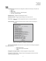
Coordinate Units- Allows the user to change the coordinate units of the map. The options are:
• Kilometers
• Miles
• Nautical Miles
• Degrees, Minutes, Seconds - Latitude/Longitude
• Fract. Deg - Latitude/Longitude
Hide/Show Grids – Toggles the coordinate grid on and off
Hide/Show All Paths – Toggles the paths displayed on the map on and off
Filter Tracks – Allows a user to filter displayed tracks based on a time period within the
simulation
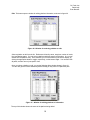
View Last Results – Displays the “Results Summary” window from the most recently run
simulation
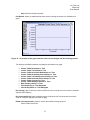
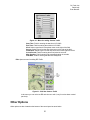
Figure 8 - An example of a summary of plotted results
Set Propagation Algorithm –Allows the user to set the method for calculating the propagation.
The available options are:
•
•
•
Distance Only (1/R^3)
Longley-Rice Irregular Terrain Model
TIREM
Propagation Coverage Animation – Activates propagation coverage animation.
Propagation Animation Style – Change the style of the propagation animation to be either
smooth or by the grid of the map.
7