1
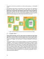
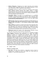
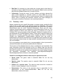
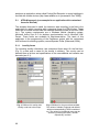
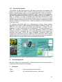
On the second form, (Fig. 4) information to the geo-referencing of the locality can
be filled in. Latitude, longitude, accuracy and the minimum altitude are filled in
automatically. The minimum and maximum altitude may be set with the two
buttons “set Min” and “set Max” in the case the research area is not on one
altitude level. But it is also possible to write values into these fields if other tools
for measuring the altitude are used. Everybody has to bear in mind that the
accuracy of the altitude measurement with GPS tools is very low. It is about 10
times lower than the accuracy for longitude or latitude.
The used coordinate system can be selected with a list box.
5.1.2.
Event forms
For each locality more than one event can be created (see 2.2). Therefore a form
exists to list all existing events for one locality (Fig. 5). The events are listed
chronological with the start date of the events. Each event can be edited or
deleted (deleting will delete also the attached species list).
Fig. 5. List of all events belonging to one
Locality ordered in chronological sequence.
Fig. 6. Editform for one event. The value
of the start time will be set automatically.
The values for the start time and end
time can be set also by pressing the
button “set Start” respectively “set End”.
61