1
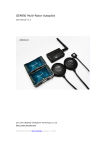
YS-X6 Multi-Rotor Autopilot
User Manual
V1.2
www.zerouav.com
1
Warning and Declaimer
1. The manual contains information about installation, debugging,and how to
use the product. Please read it thoroughly before using the product.
2. Zero UAV (Beijing) Intelligence Technology Co. Ltd. assumes no liability for
damage(s) or injuries incurred directly or indirectly from the use of this
product.
3. Please keep far away from the crowd, children and property when using the
product.
4.Install propeller after completing all the debugging and checking, to avoid
damage(s) or injuries.
5. When any of the following events or incidents has taken placed, we will not
offer any warranty and service:
(1) The product has been repaired, modified, or any parts of the product
have been substituted or replaced by anyone not expressly authorized
by Zero UAV.
(2) The warranty card, the serial number of the hardware and the flight data
or any of these items is lost.
(3) Damaged caused by use's faults such as attempting wiring not in
accordance with the manual, which may cause short circuit.
6. The user manual would be modified when the firmware and specifications
are
changed.
Please
visit
the
official
website
of
Zero
UAV
http://www.zerouav.com for the updates, or contact directly the factory,
and authorized distributors.
2
Contents
Safety Instructions…………………………………………………………………………………
YS-X6 Features……………………………………………………………………………………
In Box………………………………………………………………………………………………
Quick Start Guide…………………………………………………………………………………
Assembly…………………………………………………………………………………………
GC Software……………………………………………………………………………………
GC software Installation…………………………………………………………………
Firmware Upgrade………………………………………………………………………………
Flight Data…………………………………………………………………………………
GC Software Interface …………………………………………………………………
Remote Control…………………………………………………………………………
Data……………………………………………………………………………………
Map……………………………………………………………………………………
Setup…………………………………………………………………………………………
Parameter…………………………………………………………………………………
Test Fly…………………………………………………………………………………………
Fly………………………………………………………………………………………………
Magnetic compass Calibration
…………………………………………………
Waypoints Flight……………………………………………………………………………
Brief Troubleshooting …………………………………………………………………
Appendix
Port Definition……………………………………………………………
supported Multi-Rotor……………………………………………………
LED Description………………………………………………………………………….
3
Safety Instructions
For safety reason, please adhere to the below procedures:
1.
Please install propeller only after everything has been properly, and ensure
that the setup and installation has been completed.
2.
The side marked "IMU" of the IMU faces up. The arrow points to the front of
the aircraft.
3.
Make sure power on the RC transmitter first then power on YS-X6 autopilot
before takeoff; Power off
YS-X6 autopilot first, then power off
RC
transmitter after landing. Pay serious attention when using the S-BUS or
self-adaptive feature of the autopilot.
4.
Throttle calibration, manual servo position, realtime servo position, channel
settings must be accurate.
5.
GPS+COMPASS is sensitive to magnetic interference, should be far away
from any electronic devices. The arrowhead points to head of aircraft while
installing..
6.
Please set F/S function of RC transmitter before the flight.
7.
Do not fly in GPS mode when the signal is not good (red light blinks) or the
static GPS speed is more than 15cm/s
8.
The Gimbal Servo can be supplied power from output of any ESC, but when
ESC has no BEC output, please add extra power not use the power supplied
from Autopilot.
9.
When returning home in Auto-returning home Mode, the two ways can shut
down motors: When THR of RC Transmitter is maintained at the range of
0-10%; When staying at the bottom of cross operation interface(click
“ Control” in GCS). These two above ways can not work to shut down motors
when in other Flight Mode.
10. The low voltage protection function is NOT for experimenting, please care
about your flight time and try best to avoid using low voltage protection.
11. Please don’t launch your craft if the GCS displays very high “vibrate state”.
12. Must check whether the “course angle” and” magnetic declin” data are
4
correct after compass magnetic calibration.
13. Must check whether “Attitude angle” and“Static angle” are maintaining
consistency before takeoff.
14. When connecting the wires of GPS+COMPASS、IMU and MC, please pay
attention to keep the color of the connectors and the labeling on the Unit
body consistent. Wrong connection may result in device short-circuit.
15. Prevent Anti-plug Design The mechanisms to protect from short circuitry is
NOT for fun, please don’t try.
16. Please don’t fly in GPS mode when course angle and real rotational angle
loss consistency in some strong magnetic field, and recalibrate the compass
magnetic.
17. The system is in default when RC Receiver is on and it is in auto-flight mode
when RC Receiver is off. Please note the state of RC Transmitter when
powering on the RC Receiver.
5
YS-X6 Features Introduction
YS-Series
YS-X6 is an excellent Multi-Rotor Heli autopilot, it supports common third-party
commercial ESC and quad-rotor / Hex-rotor/ octo-rotor with common custom
mixed control. YS-X6 offers GPS Stabilization and Auto-hover functions from
quad-rotor to octo-rotor.
In Box
■Hardware □Software(Need Download)
■Main Controller(MC) X1
The MC combines with other modules, communicates with
external
electronic
devices
to
carry
out
autopilot
functionality.
Update firmware combining with PC R232 COM port.
YS-GCS software record real time flight state via WIFI
■IMU X1
(Inertial measurement unit)
Contains sensors to measure the attitude of the craft.
■GPS+COMPASS X1
The GPS/Compass module is for sensing the position and
direction.
■LED Indicator X1
The LED indicates current flight states of the craft via light.
■WIFI X1 (The Data radio can be added to spread range based on this)
1. Connect it via Mobile/Tablet hotspot function.
2. Connect AP to Ground Station via WIFI.
6
■GPS Bracket X1
GPS+COMPASS is sensitive to magnetic interference, please use this
bracket to mount GPS module when necessary and keep it far
away from EMI sources.
■3-PIN Servo Cable X8
Used to connect MC to RC Receiver.
■R232 COM port to 3-PIN Servo Cable X1
Used to connect PC to MC, Program Upgrade only.
■3M Gummed Paper (Double-side adhesive tape)
Used to fix components on multi-rotor frame
■Warranty Information Card X1
It provides Product Serial No., Purchase Date. Please fill out related
information and return back to Zero UAV for registering your product
warranty.
□GS Software for Android System □GS Software for Apple System
□Firmware Upgrade Software on PC.
7
Quick Installing Guide
Step 1:
Configure Hardware reference to “Assembly”, Please check Page XX
Step 2:
Install Software reference to “GS Software Installation”, Please check Page XX.
Step 3:
Setup RC Transmitter, please check Page XX.
c FUTABA RC Transmitter needs to make a fresh new model memory. Reverse
channels for other RC Transmitters when necessary. Example: JR. WFLY need to
reverse all channels and calibrate frequency.
d Set CH5 & CH6 to two 3-position switch on RC Transmitter.
Step 4:
Power YS-X6, connecting autopilot to GCS through WIFI, then
check whether GCS Interface displays fresh data which are keeping walking.
Step 5:
Calibrate Channels reference to “Channels Calibration”, please check Page XX.
Step 6:
Fill in parameters, please check PageXX
Step 7:
Set ESC Stroke (endpoint).
Ways: Get into the “Settings” on GCS without any power connected, push THR
stick to the maximum position and then power the craft, after twice sound “di”
push THR stick to the bottom position, meanwhile ESC will report the cell
number of battery (one “di” sound means one battery). Exit from the “Settings”
8
after completing setup.
Step 8:
Check the mixing mode, with propeller taken out for safety reason.
Ways:
Stand at the tail of the craft and watch the front. Move the Aileron stick to the
left and the left motor should stop running, do the same to the right motor. Push
the ELE stick to the top and the front motor stop running, pull back ELE stick to
the bottom and the rear motor stop running.
Step 9:
Calibrate the compass (request to perform this in flying field), Please check Page
XX
Step10:
Test fly, please check Page XX
9
10
Notice:
★ Except particular notice on wires connection, the black one of all wires should
be connected to the bottom of the pin.
★While connecting, all wirings with color should match the same color like
showing as below diagram.
★Connection labels are facing you.
★The numbers of the connectors match those marked in the diagram.
1. GPS module plug (Black)
2. GPS module plug (Red)
3. Camera
4. Gimbal Tilt (Pitch)
5. Gimbal PAN (Roll)
6. Motor8
7. Motor7
8. Motor6
9. Motor5
10. Motor4
11. Motor3
12. Motor2
13. Motor1
14. IMU module plug (Black)
15. IMU module plug (Red)
16. CH1
17. CH2
18. CH3
19. CH4
20. CH5
21. CH6
22. CH7 (shared with S.BUS)
23. CH8
24. Link to PC (Firmware Upgrade)
25. NOT USED
26. WIFI Module output
27. Power voltage (above 4S)
28. Current sensor
29. LED indicator
30. Battery (Power)
11
RC Transmitter Settings
Please read this introduction thoroughly. Because all flying mode is based on
using Channel 5 and Channel 6 of the RC Transmitter. Both channels must be set
to 3-position switches which is for switching Manual/Auto/Altitude hold 3 modes.
Users can check the working state of the switches in the “Flight Mode” on GCS
Interface. Please familiarize with the following switch position:
CH5
CH6
Position 1
Manual
Red light
blinks for 3
times
Position 2
Stabilization
Mode and
Altitude Hold
Blue light
blinks twice
×
Green light
blinks twice
1.Auto-hovering
2.Auto
Navigation/waypoint
3. Auto-returning home
Position 3
GPS Mode
×
1.
2.
Remark1
After switching to GPS Mode, CH6 is available.
Disengage any flight mode in GPS mode, need to disengage
the GPS mode.
Example: If you want to fly in Auto navigation/waypoint mode, set
CH5 to GPS mode first, then set CH6 to Auto navigation mode. If
need to disengage the Auto navigation/waypoint mode, please set
CH5 to Manual mode or Stabilization/Altitude Hold mode.
Remark2
1. “Auto-returning home” for standard version: altitude can be
controlled after reaching returning home position. After landing
the craft manually, the motors can be shut down only upon
switching to stabilization mode.
2. “Auto-returning home” for Enterprise version: aircraft can land
automatically when reaching returning position meanwhile
11 %-90% THR can not work, 0-10% THR makes the motors
power off immediately.
12
CH5 position
Position 1. Manual Mode: all flight characteristics can be controlled manually.
Position 2. Stabilization Mode (Manual) and realize altitude hold through
barometer sensor. User can control the aircraft manually but altitude is
controlled by the autopilot. We recommend to set CH5 to position 2 before
takeoff
(the motors may roll slightly) and then push ELE stick to launch the
craft; In position 2, the middle THR position is for altitude hold, push THR stick
up to make the craft climb up, push THR stick down to make the craft go down.
Position 3. GPS Mode (Auto Mode), please check the instruction of CH6
position showing as blow to activate the sub modes in GPS Mode. Also can
operate this way: after capturing the middle position of the craft before takeoff,
set CH5 to position 3 and CH6 to position 1, then push THR stick and the craft
can take off
automatically immediately.
CH6 Position( Notice: it can work only with setting CH5 to position 3 first)
Position 1. Auto-hovering in GPS Mode, the craft will hold its position with
releasing the sticks. Pushing/Pulling Elevator stick or moving the Aileron stick
left/right to make the craft move. After releasing the sticks, the craft will recover
to auto-hovering state.
Position 2. Auto-navigation/waypoint. The craft will fly away without uploading
the waypoints before switching to this position, So please make sure the
waypoints have been uploaded successfully before switching to this
position.(Please check Page XX for waypoint design and upload)
Position 3.
Auto-returning home. For setting returning home position, please
check Page XX (Returning home position).
When any accident unexpected happen, please switch back to manual mode, in
case the craft flies away.
13
Attention: Set F/S of RC Transmitter as Auto-returning home, throttle should be
kept at the range of 10% above even more, to avoid motor power off when
throttle range is reaching 10% or less. Recommend users to set 30% as the
throttle range when returning home and landing.
14
Ground Control Software (GCS)
Installation
Step1: Download YS-GCS, installing it according to operation system tips.
YS-GCS can be installed easily for Android. Installation can be completed only
need to download the GCS to mobile and run it once in file manager.
Apple installation please check Page XX
Step 2: Connection between Autopilot and GCS
Way1: Connect Autopilot to GCS through WIFI Router (Recommendation)
Way2: Build Hotspot through Mobile/Tablet.
As WIFI Module was set to default search and connect wireless network named
“YS-X6 Serial no.” example:YS-X6-10200 and password is 82890430. MUST
use WPA2-PSK AES encryption method. After the above wireless network was
built successfully, open WLAN and connect it to the router by mobile/tablet, the
communication can be established with Autopilot & Router powered on,
meanwhile realtime data can be displayed in Mobile GCS. (Namely data in GCS
keep walking means WIFI was connected successfully.)
When using Hotspot by Mobile, it can be connected only with IP Address
192.168.1.X. , otherwise please add a router to connect.
For example: If Mobile IP is:192.168.0.1,the Hotpoint function can not work.
Default User Name:YS-X6-Serial No., password: 82890430
15
Firmware Upgrade
Step1: Autopilot can not be powered. Connect 3 pin connector to the COM1 port
of the autopilot and 9 pin connector (DB9) to PC COM port.
Step2: Run firmware upgrade program (download from Zero UAV official
website), then select “configure COM port” on PC.
In the device manager of operation system, you can see which COM port is being
used, then set its property to be:
Baud rate: 115200
Data bite: 8
Parity: None
Stop bit: 1
Step3: Select a “.arm” file offered by Zero UAV to upgrade.
Step4: Power the autopilot, Upgrade can be completed automatically. When it
says in red words “Upgraded, please close the window.” , can shut up the
autopilot.
16
Flight data
All the realtime flight data will be saved automatically to a “hj” folder under the
local file named “T+runtime” in mobile when flying. The flight tracking file for
Apple is saved to the folder:/private/var/mobile/documents/yswifi
When users meet a flight problem, can send it back to the factory if need. This
file is also one of the necessary documents for warranty, please preserve
carefully.
17
GCS Interface
Software Functions:
No.
Content
Functions
1
Control
Default interface. Flight interface by Mobile
2
Data
Realtime flight data of the craft
3
Map
Saved map or realtime map
4
Settings
Set craft states
5
Parameters
Adjust parameters of the craft
6
Control
Interface
Mix Control by Mobile
7
Center Button
Control the aircraft by mobile
8
Control Cross
Control the craft to Climb/ Go down/rotate by mobile
9
RC on/off
Control the craft by mobile after opening it.
10
Magnetic field
data
Show the Magnetic field calibration results
11
IP Searching
Reserved
12
Quit
Quit from the software
18
Control
After switching the RC Transmitter to Auto-hovering mode in GPS mode, click
mobile menu, if mobile has got into the Control then you can use the Mobile to
control the craft.
Operation Listed as below:
1.The craft will Auto-hover with altitude hold and position hold when no touching
the GCS control cross.
2.Press down the middle circle and keep it, moving your finger to
left/right/front/back or to any direction, the craft will move same like when
using the aileron and elevator sticks of RC Transmitter. (In order to classify the
difference from adjusting flight direction/ altitude , mobile will vibrate once
when start to operate.)
3. When moving your figure on the green cross (no pressing the middle circle),
up/down is for adjusting altitude, the more higher position means the faster
climbing speed, the more lower position means the lower declining speed. The
craft will hold its position and altitude when releasing your finger. Left/right is for
for changing the flight direction, the same operation as up/down.
4.When the craft flies out of WIFI communication range and the autopilot can
not
receive mobile signal, it will be automatically switched to accept signal
from RC Transmitter. When the craft flies back to the WIFI range, mobile can be
automatically recovered to control the craft again.
The Remote control functions shown as below:
"Control"
open
Operation method on "Control" interface
Aircraft states
Circle area
Red: unlocated; Green: located.
Keep still
Hover
Operation
Do NOT touch any area
Altitude hold and Position
hold.
1.
Level flying
Operation
2.
3.
Press hold the center circle and move
up/down
Press hold the center circle and move
left/right
Press hold the center circle and move left
top, left bottom, right top, right bottom.
19
1. move to front or back
2. Move to left or right
3. Move to left top/left
bottom/right top/right
bottom.
Climb/ Go
down/Rotate
Operation
1.Skip touching any position to right top from
the circle(Within the green cross area)
2.Skip touching any position to right bottom
from the circle(Within the green cross area)
3. Skip touching any position to left from the
circle(Within the green cross area)
4.Skip touching any position to right from the
circle(Within the green cross area)
Attention:
(1)
The distance to the red dot is the flight
speed. The further the faster.
(2)
Press holding time is flight time.
(3)
The craft will auto-hover when
releasing your finger.
(4)
The Maximum speed is 2.5 m/s
1.
2.
3.
4.
Climb
Go down
Rotate to the left
Rotate to the right
The bottom
of the green
cross
Activate "Disable motors” only when in
auto-returning home, please use carefully.
Shut down the rotors
immediately
WIFI data
lost when
flying
The craft will auto-hover with exceeding WIFI
range and switch to be controlled by RC
Transmitter.
Auto-hover
Reget WIFI
signal
Automatically Start " Enable control"
Depend on current mobile
states
20
Data
Get into the data interface by touching the button "Data", shown as below:
GPS Satellites:
Locate GPS Satellites Quantity.
GPS Velx(cm)
GPS Vely(cm):
GPS speed. Position hold is better when the value is below 10.
Xekf Velx
Xekf Vely
Xekf Veld:
The speed after Kalman filting. When the flight speed exceed normal range, the
LED of autopilot will indicate solid white, means obstacle happened and need to
land urgently. Value below 20 is normal when the craft is static on ground.
Attitude Angle:
Real time attitude when flying.
Static Angle:
21
Real Attitude data when the craft is static. Static Angle can work only with no
any vibration. When existing different value with checking on ground, need to
operate " Zero Gyro" in GCS.
Target Point:
Waypoints number, upload the waypoints number to the craft which will fly, it
can not exceed the total waypoints or keep as 0.
Flight Mode:
Craft states: Zero Gyro, Manual, Auto-waypoints, Auto-navigation, Return
home and land, settings.
Flight Altitude:
Barometer altitude of the craft, unit is meter.
Course Angle:
Course Angle means the directions which the craft head points to. Due North=0
degree, clockwise direction is positive, counterclockwise direction is negative.
For example: Due East=+90 degree, Due West=-90 degree, Due South=+180
degree or -180 degree.
Note: The Course Angle can mean real flight direction only with GPS was located
and switched to Auto Mode.
It has no physical meaning in other
circumstances.
AP Volt:
Autopilot voltage ( has loaded)
GPS Lat
GPS Lng
GPS longitude and latitude.
22
Manual Servo Position
Rudder
Elevator
Aileron
Throttle
For example: When RC Transmitter is in the center position and throttle is the
minimum, it displays rudder:“ Middle", throttle:7,
if deviation value is more
than 2, need to capture center position.
Vibrate State:
It displays the influence of vibration from different directions on IMU. Shock
absorption effect is not good when vibration value is more than 10.
For example: up/down 15 means the vibration influence on IMU from up/down
direction is relatively great.
23
Map
+:Zoom in
-:Zoom out
Map: map mode.
Satellite:
satellite mode (select according to the real situations)
Tips:
1. The map will stay back to the last one by default when get
into it next time.
2. When network is not connected, click to open WIFI, it will display cache data.
24
Locate Map
Locate Plane : (Craft position)
Click this button to find the craft position after GPS located.
My Location:
(My position)
Search Location: (Search Position)
Save Location (Save Position)
Load Location (Load position)
Fly ToPP
It only can be used in Auto-hovering state. Click any position on the map and a
yellow smile will show up there, then click the button ‘Fly ToPP“ the yellow
smile shall change to purple smile,after that the craft will fly to the position and
hover there.
25
PTZ Lock:
It only can be used in Auto-hovering state. Click any position you want on the
map and a yellow smile will show up there, click the button "PTZ Lock" and
yellow smile will chang to purple smile, after that the craft head will point to this
position, at this time user can operate on "Control" interface: when move
aileron to left the craft will hover clockwise around the locked point, when move
aileron to right the craft will hover counterclockwise around the locked point.
Tool
To design waypoints.
Please check Page XX “ Fly Waypoints" about the operation steps.
26
Settings
Note:
All operations in settings are vitally important, please operate seriously.
Zero Gyro
1. Check the data state, when the craft is static on the ground and the val
Zero Gyro
1.Check the data state, when the craft is static on the ground and the value
between Attitude Angle and Static Angle is difference, please go this
Operation.
2. After confirming this operation, the flight state will change to " Please waiting
for Zero Gyro", wait patiently till the flight state changes back to "Manual".
3. After Zero Gyro, if the Attitude Angle and Static Angle is same means operate
Successfully.
27
Key tips: Absolutely prohibit to Zero Gyro when flying, it can be operated only
with no any vibration.
Magnetic Compass
Click into magnetic compass calibration mode, the below area in grey is
displaying calibration state, Please check Page XX about the calibration steps.
Neutral Position
After channel calibration release operation sticks, if Rudder in GCS displays not
"Middle" , or when tuning RC Transmitter slightly, that needs to capture the
Neutral Position.
Home Location
It records a returning position when takeoff. If switch to Auto-returning &
landing by RC Transmitter, the craft will fly to the recorded returning position
automatically and then land slowly. But if need to change the returning position,
Please record the plane coordinates of aircraft at any time any position you want
by using this function, then switch to auto-returning & landing mode, it can get
back to the new returning position.
Back Landing
This function can be activated only by switching CH5 to position 3 or by
powering off the receiver.
After sending out this command, the craft will return
back to home location automatically and then land slowly. If the above
conditions cannot be met, the craft will not response to the command, at this
time you can only operate by switching the sticks on RC Transmitter to let it
28
return and land. The craft can land only after it reaches home location, during
the landing, can also control the location by moving Aileron and Elevator sticks
of RC Transmitter, it's same as Auto-hovering operation.But if the Elevator and
Throttle stick have been pulled to the bottom, the craft will stop immediately. If
Throttle stick is at other position except at the bottom, it won't influence to land.
Auto Take Off
Power off the receiver first and then click "Enable Control" in GCS, at last click
this button "Auto Take Off", the craft can take off automatically.
Attention:
It will result in crashes if operate to take off first and not switch to "Control"
interface timely.
Enable RC
Disable RC
It's used to control the receiver on/off. When the receiver is on, the craft can be
controlled by
RC Transmitter. When the receiver is off, the craft is in
independent flying,(Switch from RC Transmitter to independent flying: switch to
GPS Mode by RC Transmitter fist, then get into "Control" interface in GCS, click
the button "Disable RC"). After disabling the receiver, craft will not be controlled
by RC Transmitter. Whenever want to enable the receiver, please
check the current state of RC Transmitter first.
29
noted to
Enable Follow
This function can be used only with the below conditions at the same time:
1. There is GPS hardware in ground station.
2. GPS satellites are more than 4.
3. RC Transmitter has been switched to Auto-hovering and altitude hold/position
hold.
4. The receiver is off.
After enabling Follow Me, the craft will fly automatically following mobile GPS
position, fly Follow Me.
Change Target
In waypoints mode, if want to fly a new waypoint can change it
here to fly new current waypoints which has been uploaded.
Attention:
Fill in a number which can not exceed uploaded waypoints number.
Change Altitude
In waypoints mode, it's used to set flight altitude, put in altitude needed here.
Example: filling in 10 means setting flight altitude as 10 meters.
Channel Align
Please confirm to align the channel without any electric power connected.
Example: When moving Throttle stick as Minimum-Maximum-Minimum, if GCS
data displays as below:
Manual Throttle is 7 when Throttle stick is at the
Minimum position and 9 when at the Maximum position, that means Channel
Align is completed successfully.
Special Attention;
Please don't configure propeller when power first time, only power the autopilot
and need to calibrate Channel Align first.
30
Operation as blow:
Select "Channel Align" in Settings, push/pull Elevator sticks of RC Transmitter to
the Maximum/Minimum, move Aileron sticks of RC Transmitter to the
leftmost/rightmost within 5 seconds. After 5 seconds, autopilot will complete
collecting data automatically. User can observe whether the data shown in GCS
can match with real manual operation when was moving the sticks.
Example:
1. When pulling Throttle stick to the Minimum, the " Throttle" showing in GCS
displays 7; Pushing to the Maximum, it displays 90.
2. When moving Aileron stick to the leftmost, the "Aileron" showing in GCS
displays 40; to the rightmost, it displays 40.
3. When moving Rudder stick to the leftmost, the "Rudder" showing in GCS
displays
40, to the rightmost, it displays 40.
4. When pushing Elevator stick to the Maximum, the "Elevator" showing in GCS
displays 40, pulling to the Minimum, it displays 40.
They displays "Neutral Position" without any movement.
Please make sure the Throttle stick is at the Minimum position before take off,
and flight mode/CH5 must be in Manual. Otherwise it's extremely possible to
result in Injures or Damages caused by rotors rotates suddenly after connecting
power. (It takes FUTABA as standard example with no any reversed-directions
set. If use WFLY RC Transmitter, it requests to reverse directions, please make
sure the value displays in "Data" of
Rudder/Aileron/Elevator/Throttle in GCS
can match with real operation when moving each stick from the Minimum to
Maximum, otherwise need to reverse directions of RC Transmitter channel.)
Init Setup
It's used to align channels or complete parameters of craft. After clicking this
button, flight state will display "Settings". After getting into settings, the control
channels for each motor on craft is directly connecting to throttle channel of RC
Transmitter and no any mix control output, it is equal to like a Y-line of
"one to
many" , it's convenient for users to set strikes for all rotors at the same time.
31
Quit Setup
After completing Throttle channel calibration and all parameters filled, click this
button to exit from settings.
Enable Skyway
The craft can be switched to Auto-navigation mode only after set CH6 to
Auto-navigation and then click this button "Enable Skyway" to open the
waypoints first.
32
Parameters
Please do NOT change the parameters of Roll/Pitch/THR/Rotate PID.
Cell Num
The autopilot can calculate the low voltage alert according to the Cell Number
filled in by users. When the mobile vibrates once each 2 seconds, it means the
power is getting low and remind user to note. When the mobile vibrates once
each 1 second, it means the power is getting very low and request the craft to
land at once.
Ctrl Type
Complete default number 2.
1. Attitude mode, fit to adjust parameters/dynamic flight.
2. Acceleration mode, fit to static flight.
Magnetic Declin
Fill in local magnetic declination, deflection to West is Positive/to East is
negative ( most regions in China are deflecting to West).
33
Example: Magnetic declination is 6 degree 30’ West, namely 6.5 degree, then fill
in 6.5.
Please refer to the below website about magnetic declination
http://www.ngdc.noaa.gov/geomagmodels/struts/calcDeclinat
Aircraft Type
Fill in mix control type, please refer to Appendix 2.
PTZ Roll Sensitivity
PTZ Pitch Sensitivity
It’s used to adjust the compensation angle of PTZ. If user feel the compensation
angle is small, can fill in bigger number, on the contrary fill in smaller number
(Note: can fill in negative value)
Max Speed
Set flight speed.
The four parameters shown as below need to be filled in when use first time.
Please get into the "settings" to put in the four parameters and upload it to the
Autopilot first,
it can be allowed to fly only after getting the parameters by
clicking the button "Get".
Remote Control Mode
Can select the options according to the RC Transmitter which is been using.
Adaptive: the autopilot can select the remote control mode automatically
according to the RC Transmitter which is been using.
Normal: Normal FUTABA Receiver, autopilot CH1 connects to receiver CH1,
34
autopilot CH2 connects to receiver CH2.
S-BUS: Only connect autopilot CH7 to the receiver S-BUS port
JR Satellites;the current firmware does not support JR Satellites temporarily,
but later firmware will support.
Volt Alert Threshold
Fill in the alert voltage of each battery which is been using, need user to fill in
after measuring by self. Usually fill in 3.65
ESC Type
Fill in the ESC type which is been using.
Note: Fault filling of Normal ESC and XA ESC will result that the propellers go out
of control after power connected.
Steering gear Frequency
Input the correct value according to your servo type: 50HZ for Analog Servo,
250HZ and 330HZ for Digital Servo.
35
Trial Fly
Check before Takeoff:
Please make sure your Multi-rotor has been assembled correctly.
Please make sure you have set all parameters correctly.
Any one of the situations as below may result in serious accidents.
The motors rotate reversely.
The propellers are assembled in wrong way.
The IMU is assembled in wrong way.
The components are assembled in wrong way.
Special attention:
Switch on the RC Transmitter first and then the receiver. Power on AP first then
connect motive power for Multi-rotor.
Please adjust the attitude sensibility and trial fly in Auto-hovering mode in
empty & weak-wind space
Please check whether the hj file has been saved to the mobile successfully (Only
if power the autopilot, hi file can be formed after the data connected.)
36
Fly Test
Step1: Make sure adequate power to the RC Transmitter/Autopilot and all
components.
Step2: Check all the connections to make sure everything is in good condition.
Step3: Turn on RC Transmitter first, then start the Multi-Rotor craft.
Step4: Make sure that the flight mode can be changed normally through flipping
the transmitter switches and checking it.
Step5: Get into Auto-hovering mode. Move the sticks to check the movements
of Elevator/Roll/Course Angle whether are all correct. If not, please get back to
parameter settings to revise it.
Step6: Move the Throttle stick slowly to make all motors start work, then make
your Multi-rotor aircraft take off slowly.
37
Fly
Magnetic Compass Calibration
Onboard magnet or neighboring magnetic filed will affect the performance of
the Magnetic Compass and reducing the precision of the sensor, it could even
cause serious problems. You can reduce this risk by performing compass
calibration to make sure the autopilot can work properly.
When to perform Magnetic Compass Calibration:
1. When use for first time.
2. When machinery assembly of Multi-Rotor craft is changed.
3. When the mounting position of GPS module is changed.
4. When the mounting position of electronic devices are changed, such as
adding/removing/moving the Main Controller, Servo, Battery etc.
5. When the machinery structure of Multi-Rotor is changed.
6. When there is some drift. For example;the craft can not move forward in a
straight flight path.
38
Calibration Steps
Step1:
Select "Horizontal Alignment" after clicking Magnetic Compass.
After confirmation, it will display whether autopilot received the command of
Horizontal Alignment from GCS, if it says "Success", then start to horizontally
rotate the craft 2-3 laps slowly, ask a helper to monitor the attitude angle
changing in “Data” and try best to keep Pitch and Roll value smaller than 3 when
rotating ( Example: L2/D2 is OK, but L3/ D2 is not good; It does not matter to
exceed 3 occasionally, autopilot will stop collecting data while exceeding 3 and
go on collecting when recover to be within 3),
you can also check the blinking
light which is connecting with autopilot, blinking light means attitude is good, if
attitude is too big the light will turn off.
Step2:
After completing
2-3 laps horizontal rotation, please let the craft head face to
39
the ground vertically, then select “Vertical Alignment” from "Magnetic
Compass" in GCS and click "OK" to send the command to autopilot. After it
says "Success", go to check the "Attitude Angle" in "Data", L/D will be changed
close to 0 slowly (namely changed the coordinate reference , it's horizontal
when craft head faces to the ground.) Then take the craft head as Axis and keep
attitude angle less than 3 degree, rotate 2-3laps horizontally. You can also
check the blinking light which is connecting with autopilot, blinking light means
attitude is good, if attitude is too big the light will turn off.
Step 3:
Magnetic Compass calibration is completed with performing the above
operations, and the GCS will switch to "Control Cross’interface automatically,
after a few seconds, it will display the magnetic sensor data of autopilot,
only
look the red and blue circle in the middle of cross coordinates, if they are close
to standard round, that means calibrate successfully and data is in good
condition.
40
41
Waypoints Fly
Step1:
Click “tools”->
" Design waypoints'. One click on the map can get one waypoint,
get all waypoints one by one. Click “Default Tool” to complete the waypoints
design.
Step2:
After the waypoints drawing is completed, click "Upload Waypoints" to the
Autopilot. To confirm a successful upload by checking whether each waypoint
has been changed to blue or get into " Target Point" and check whether the
number displays there is same with uploaded waypoints, if not you need to
upload again.If any waypoint is not changed to blue, please also upload again.
Step3:
Click “Remove Waypoints” to recover the blue waypoints to red, then select
“Verify waypoint” from “Tool”, download uploaded waypoints to ground station
for comparing, if all waypoints are blue, that means the uploaded waypoints is
42
same with that in GCS and waypoints checking succeed. Otherwise need to
upload waypoints again.
Step4:
After switching CH5 to position 3 and CH6 to Auto-navigation, autopilot will get
into Auto-waypoints Mode and go to waypoint 1 & hold position. Fill in "Change
Target" with number 2 and upload it, the autopilot will fly to waypoint 2、3、
4...and fly back to waypoint 1 and hover there after finished all waypoints.
43
Troubleshooting
1
Check
Craft is rotating
whether
the
Magnetic
Compass
Calibration is correct.
Vibration exceed limit, please try to reduce
2
Altitude is changed
the vibration from rotors and balance the
propellers.
1.Check whether ESC wire connection and
3
Craft rolls when taking off
MC wire connection are correct.
in stabilization mode
2.Check whether IMU is mounted at right
position and direction is correct or not.
1.Check any wires get loosen.
2.Exceed WIFI communication range.
3. Tablet/Mobile is in low power.
4. Enable Control and try to analog control
the craft, check whether LED light blinks
4
No WIFI signal on the
Tablet/Mobile
regularly,
if
not
please
check
autopilot-mobile-WIFI data connection.
5. Whether set the SSID as YS-X6-X( Serial
number).
6. Whether router IP is :192.168.1.1
Altitude changes too much
5
Vibration exceed limit.
when the movement is
bigger
6
Craft is not stable after
Shake exceed limit.
position hold.
Not located, still not start to calculate the
7
Drifting
much
in
the
formal attitude data
position hol
8
Can not control the craft in
Did
not
44
locate
position
and
calculate
stabilization mode
attitude
Appendix
Appendix1: Each port definition.
MC
CH1
Aileron
CH2
Elevator
CH3
Throttle
CH4
Rudder
CH5
Manual/Auto Mode
CH6
Auto-mode
CH7
S-BUS supported
CH8
COM port, connect to PC to upgrade
COM1
firmware
COM2
COM3
Connect WIFI module
AI0
AI1
Connect Power Calculate Module
LED
Connect LED Indicator
IMU1
IMU module power interface
IMU2
IMU module data interface
M1
Motor 1
M2
Motor 2
M3
Motor 3
M4
Motor 4
M5
Motor 5
M6
Motor 6
M7
Motor 7
45
M8
Motor 8
EXT1
Gimbal Tilt
EXT2
Gimbal Pan
EXT3
GPS1
GPS module power interface
GPS2
GPS module data interface
46
Appendix 2:
Supported Multi-Rotor
On the Multi-Rotor with coaxial double propellers , blue stands for the propellers
configured on the top side, purple stands for propellers configured at the bottom
side. In the other situations, all the propellers are on the top.
The arrow in the figures means the head of aircraft. “Aircraft Type” in the
parameter settings can be filled with the number at the right bottom of the
aircraft illustration below.
47
0
1
2
3
5
4
6
7
48
8
Appendix 3 : LED description
GPS unlocated, red LED blinks for 3 times one loop.
GPS located (5 satellites), red light blinks for 2 times one loop.
GPS located (6 satellites), red LED flashes for one time one loop.
When located GPS satellites is more than 7, the Red light be solid all the time.
When the Speed data got from the Kalman filtering data fusion using the GPS
data is too large: the LED will be solid white, need to land the aircraft urgently.
Altitude hold in the Stabilization mode: Blue light flashes in loops, one time one
loop means the users is controlling manually, two times one loop means Altitude
hold.
In the GPS mode, green LED flashes in loops. One time one loop means the user
is controlling manually, two times one loop means GPS position hold with
altitude hold and auto-hover
49
Zero UAV (Beijing) Intelligence Technology Co., Ltd.
Add.: Rm.106,Building 64 Block2B,Xi’erqi Lingxiu New Silicon Valley,
Haidian District, Beijing, China 100085
Tel.: +86(10)-8289-0430
Fax:
+86(10)82890430-808
Web.:www.zerouav.com
50