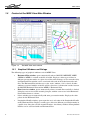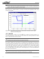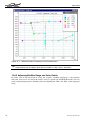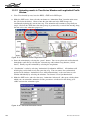
1
MIKE VIEW
a Results Presentation Tool for
MOUSE, MIKE SWMM,
MIKE NET and MIKE 11
User Guide and Tutorial
MIKE VIEW
DHI Water & Environment
Agern Allé 11
DK-2970 Hørsholm
Denmark
Tel:
+45 4516 9200
Fax:
+45 4516 9292
E-mail: [email protected]
Web:
DHI Water & Environment
www.dhi.dk and www.dhisoftware.com
CONTENTS
CONTENTS
1
2
3
GETTING STARTED ..................................................................................1
1.1
How to read this user guide ............................................................................ 1
1.2
Introduction ..................................................................................................... 1
1.3
Installation of MIKE View ................................................................................ 2
1.4
Starting the MIKE View GUI ........................................................................... 2
1.5
Content of the MIKE View Main Window........................................................ 4
1.5.1
Graphical Windows and Dialogs........................................................ 4
1.5.2
Menus ................................................................................................ 5
1.5.3
Toolbars ............................................................................................. 5
1.5.4
The Status Bar ................................................................................... 6
WORKING WITH RESULT FILES..............................................................7
2.1
Selecting a File for the Presentation............................................................... 7
2.2
Selecting Data for the Presentation ................................................................ 7
2.3
Adding a File................................................................................................... 8
2.4
Closing a File .................................................................................................. 8
VIEWING DATA IN A HORIZONTAL PLAN ...............................................9
3.1
The local menu for the Horizontal Plan........................................................... 9
3.2
Selecting the Horizontal Plan Type............................................................... 10
3.3
Controlling Symbols and Fonts..................................................................... 11
3.4
Importing a Background Map ....................................................................... 13
3.5
Controlling the Axes...................................................................................... 14
3.6
Using Graduated Symbols............................................................................ 15
3.7
Zooming........................................................................................................ 16
3.8
Controlling the Palette .................................................................................. 17
DHI Water & Environment
i
MIKE VIEW
4
5
6
7
VIEWING LONGITUDINAL PROFILES ....................................................21
4.1
Selecting a Profile ......................................................................................... 21
4.2
Working with the Local Menu........................................................................ 22
4.3
The Options for the local menu..................................................................... 23
VIEWING TIME SERIES...........................................................................25
5.1
Selecting a Time Series ................................................................................ 25
5.2
Working with the Local Menu in the Graphical View..................................... 27
5.3
Working with the local menu......................................................................... 28
5.4
Adding Time Series to a Graph..................................................................... 29
5.5
Getting Detailed Information ......................................................................... 30
5.6
Duration Curves ............................................................................................ 30
5.7
Error Estimation ............................................................................................ 31
5.8
Accumulated Values ..................................................................................... 33
VIEWING Q-H RELATIONS .....................................................................35
6.1
Selecting the Location................................................................................... 35
6.2
Working with the Local Menu........................................................................ 35
OPERATING WITH SUBJECTS ...............................................................37
7.1
8
9
ii
Creating subjects .......................................................................................... 37
ANIMATION OF RESULTS ......................................................................41
8.1
Animating a Presentation.............................................................................. 41
8.2
Controlling the Animation.............................................................................. 41
8.3
Synchronizing the Animation......................................................................... 42
EXCHANGING DATA ...............................................................................43
9.1
Exporting Graph Data ................................................................................... 43
9.2
Exporting Windows ....................................................................................... 43
DHI Water & Environment
CONTENTS
9.3
Including External Time Series ..................................................................... 43
9.4
Printing.......................................................................................................... 45
10 TOOLS AND ACCESSORIES .................................................................. 47
10.1 Computing Derived Items ............................................................................. 47
10.2 Saving Window Layout ................................................................................. 49
10.3 Saving Complete Layout............................................................................... 49
10.4 Changing Units ............................................................................................. 50
10.5 The MIKEVIEW.INI File ................................................................................ 51
10.6 The Load Geometry feature ......................................................................... 52
10.7 The Info Mode............................................................................................... 52
10.8 The Trace Functionality ................................................................................ 53
10.9 Discharge Capacity Module.......................................................................... 53
11 RESULT VERIFICATION TOOL...............................................................56
11.1 Description of the tool ................................................................................... 56
11.2 Description of the functionality...................................................................... 61
11.2.1 Main dialog....................................................................................... 62
11.2.2 Presentation set dialog .................................................................... 64
11.2.3 Presentation of the results ............................................................... 65
12 MOUSE/MIKE SWMM: MIKE VIEW TUTORIAL ......................................69
12.1 What Will I Learn? ........................................................................................ 69
12.2 Before You Begin.......................................................................................... 69
12.3 About MOUSE Result Files .......................................................................... 69
12.4 What Are We Going to View......................................................................... 70
12.5 Loading Results ............................................................................................ 70
12.6 Exploring the MIKE View Screen.................................................................. 72
12.7 Viewing System Data.................................................................................... 72
DHI Water & Environment
iii
MIKE VIEW
12.7.1 Zooming ........................................................................................... 74
12.8 Viewing Results............................................................................................. 75
12.8.1 Selecting Result Variable and Plot Type .......................................... 75
12.8.2 Animation of the Horizontal Plan...................................................... 75
12.8.3 Graduated Symbols ......................................................................... 76
12.8.4 Flooding ........................................................................................... 76
12.8.5 Adjusting Min/Max Range and Color Palette ................................... 78
12.8.6 Exporting the Horizontal Plan........................................................... 80
12.9 Viewing Results in a Longitudinal Profile ...................................................... 80
12.9.1 Selecting a Longitudinal Profile ........................................................ 80
12.9.2 Animating a Longitudinal Profile....................................................... 81
12.9.3 Synchronizing Animations ................................................................ 81
12.10 Viewing Time Series ..................................................................................... 82
12.10.1 Adding a Result File ......................................................................... 82
12.10.2 Selecting a Time Series ................................................................... 82
12.10.3 Adding Items to a Time Series Graph.............................................. 83
13 MIKE11: MIKE VIEW TUTORIAL .............................................................85
13.1 What Will I Learn? ........................................................................................ 85
13.2 Before You Begin .......................................................................................... 85
13.3 About MIKE 11 Result Files .......................................................................... 85
13.4 Starting MIKE View ....................................................................................... 86
13.5 Selecting Data for the Presentation .............................................................. 86
13.6 Horizontal Plan Options ................................................................................ 87
13.6.1 Horizontal Plan Window Options...................................................... 88
13.6.2 Background Images ......................................................................... 91
13.7 Viewing Time Series in Grid Points............................................................... 93
13.7.1 Selecting and displaying a time series from a grid point in the
Horizontal Plan Window ................................................................... 93
13.7.2 Selecting and Displaying a Water Level Time Series from a List .... 95
13.7.3 Adding time series to the TSW ........................................................ 95
iv
DHI Water & Environment
CONTENTS
13.7.4 Deleting time series in the TSW ...................................................... 96
13.7.5 Time Series Info............................................................................... 96
13.7.6 Copy Graphics ................................................................................. 97
13.8 Viewing Water Levels In Cross Sections...................................................... 97
13.8.1 Selecting and Displaying a Time Series from a Link ....................... 97
13.9 Viewing Q-H (Discharge-Stage) Curve......................................................... 98
13.9.1 Selecting and Displaying a Q-H (Discharge-Stage) Curve .............. 98
13.10 Viewing Longitudinal Profiles ...................................................................... 100
13.10.1 Selecting and Displaying the Longitudinal Profile .......................... 100
13.10.2 Longitudinal Profile Options ........................................................... 101
13.11 Zooming In The Graphical Windows .......................................................... 105
13.11.1 Zooming in the Horizontal Profile Window..................................... 105
13.11.2 Zooming in the Time Series Window and the Longitudinal Profile
Window .......................................................................................... 107
13.12 Animating Results in the Longitudinal Profile Window ............................... 107
13.12.1 Animating results in Time Series Window and Longitudinal Profile
Window .......................................................................................... 108
13.13 Animating Results In The HPW .................................................................. 109
13.13.1 Animating results in Horizontal Profile Window, Time Series Window
and Longitudinal Profile Window ................................................... 109
13.14 Viewing Derived Results ............................................................................. 110
13.14.1 Computing and viewing derived results in TSW and LPW ............ 111
13.14.2 Viewing derived results in HPW..................................................... 111
13.15 Save/Load Window Layout ......................................................................... 111
13.15.1 Save Time Series Window Layout................................................. 112
13.15.2 Load Time Series Window Layout ................................................. 112
13.16 Save / Load Complete Layout .................................................................... 112
13.16.1 Save Complete layout.................................................................... 112
13.16.2 Load Complete layout .................................................................... 113
13.17 Opening Additional Result Files.................................................................. 113
13.17.1 Opening a Second MIKE11 Result Files........................................ 113
DHI Water & Environment
v
MIKE VIEW
13.18 External time series .................................................................................... 114
13.18.1 Copying Discharges to ETS ........................................................... 115
13.18.2 Working with ETS .......................................................................... 116
14 MIKE NET: MIKE VIEW TUTORIAL .......................................................117
14.1 Loading Result Files ................................................................................... 117
14.2 Adding a Georeference File for Mike Net ................................................... 118
14.3 Viewing System Data .................................................................................. 119
14.3.1 The Plan Type................................................................................ 120
14.3.2 The Symbols and Fonts ................................................................. 120
14.3.3 The Axes ........................................................................................ 122
14.4 Controlling the Palette................................................................................. 124
14.5 The Longitudinal Profiles ............................................................................ 126
14.6 Time Series................................................................................................. 126
14.7 Forward and Backward Tracking ................................................................ 130
vi
DHI Water & Environment
MIKE VIEW
1
GETTING STARTED
1.1
How to read this user guide
MIKE View is a map-based GUI for the presentation of results from the MOUSE, MIKE
SWMM, MIKE NET and MIKE 11 one dimensional, looped network, software packages. MIKE
View is a true 32-bit Windows application, running under Windows and Windows NT operating
systems.
MIKE View is designed to service several different DHI Software packages. As the content of
result files for these different software packages varies, the features of MIKE View will also vary
with the type of model result file being viewed.
In this user guide both the generic MIKE View features used to display results from the many
different model result files and the product specific MIKE View features are described. The user
guide follows the format of providing general information on features applicable to all model
result files followed by product specific features described in relevant subsections.
1.2
Introduction
MIKE View is a standard part of the Windows versions of MOUSE, MIKE SWMM, MIKE NET
and MIKE 11 packages but is also available as a stand-alone result presentation tool.
MIKE View can display results from
•
•
MOUSE Runoff, HD, LTS, AD, WQ and ST simulations
MIKE SWMM (Results from Runoff, EXTRAN and TRANSPORT are converted to
MOUSE result files and then loaded into MIKE View)
•
MIKENET HD and WQ
•
MIKE 11 NAM, HD, AD, WQ and ST simulations.
All these results can be displayed in combination with the time series taken from other sources
external to the result file such as ASCII files, MOUSE and MIKE 11 time series databases, etc.
Please note that since the MIKE SWMM results need to be converted to MOUSE result files
before they are loaded into MIKE View all features valid for MOUSE are also valid for MIKE
SWMM.
The results can be presented as:
•
•
•
•
Color animations or static plots on a Horizontal Plan
Animated longitudinal profiles
Time series and duration curve graphs
Q-H relations
! MIKE
View is undergoing continuing development. We would welcome your comments and
suggestions for future versions. Please feel free to pass on your comments to DHI directly
or via your local DHI agent.
DHI Water & Environment
1
MIKE VIEW
1.3
Installation of MIKE View
See the ‘Installation Guide for MIKE View’ for installation instructions. If MIKE View was
purchased as a part of a MOUSE, MIKE SWMM, MIKE NET or MIKE 11software package,
then MIKE View will be installed automatically with the installation of these software packages.
1.4
Starting the MIKE View GUI
The MIKE View GUI can be activated from various locations. The program is activated from
Windows by double clicking on the ‘MIKE View’ icon in the MOUSE, MIKE NET, MIKE
SWMM or MIKE 11 program group.
Figure 1-1
Example of how to start MIKE View from the program group
For convenience, MIKE View may also be started from within MOUSE by activating the
“Project | Start MIKE View” menu option or by clicking on the MIKE View button in the
toolbar.
2
DHI Water & Environment
GETTING STARTED
Figure 1-2
Starting MIKE View from within MOUSE
Once activated, the program prompts the user to open a result file and select the data you want to
load. Choose the file you want to view and click the ‘OK’ button.
Figure 1-3
DHI Water & Environment
Choosing between the different result files
3
MIKE VIEW
1.5
Content of the MIKE View Main Window
Figure 1-4
The MIKE View main window.
1.5.1 Graphical Windows and Dialogs
The following types of graphical windows exist in MIKE View:
•
•
•
•
4
Horizontal Plan window, opens automatically when a MOUSE, MIKENET, MIKE
SWMM or MIKE 11 network result file is loaded. Displays various types of data in
different presentation modes in a plan view of the urban drainage or river network. Only
one Horizontal Plan window can be associated with each of the loaded network result
files. The Horizontal Plan window acts as the ‘main’ window - if it is closed, all other
windows associated with the result file will be closed too. A distinction is made between
the MOUSE Horizontal Plan and the MIKE 11 Horizontal Plan.
Plan Overview window, opens automatically when a network flow result file is loaded.
It displays an overview of the network plan plot, with the current area in the Horizontal
Plan window shown as a frame.
Palette window opens automatically with some presentation modes. Displays the color
palette for the Horizontal Plan.
Longitudinal Profile window, opens upon the user's selection of the Longitudinal Profile
on the Horizontal Plan. Displays various types of data in different presentation modes in
a profile view along the selected network branches. An arbitrary number of Longitudinal
Profiles can be associated with one Horizontal Plan.
DHI Water & Environment
GETTING STARTED
•
Time Series window, opens upon the user's selection of a specific item on the Horizontal
Plan. Displays various types of data as time series graphs. Each time series window
contains one graph, however multiple time series can be presented in the same window.
An arbitrary number of time series can be associated with one Horizontal Plan.
•
Duration Curve window, opens upon the user's selection of the “Duration Curve”
option for the currently active time series plot. Displays the time series and the duration
curves for the time series. In the right-hand side of the window, tables with numerical
values are presented.
•
Q-H Relation window, opens upon the user's selection of a specific location on the
Horizontal Plan. Displays Q-H relations for a network branch at the selected location.
An arbitrary number of time series can be associated with one Horizontal Plan.
Apart from graphical windows, MIKE View contains a number of dialogs for display
configuration and for tabular data display.
1.5.2 Menus
The MIKE View main menu contains the following items:
•
File: files can be opened, added, closed, presentation layout loaded, the program
terminated, graphics from the active window printed
•
View: elements of the MIKE View outlook can be switched ‘ON’ or ‘OFF’, and the
appearance of the Horizontal Plan can be controlled
•
Plot: selection of various items to be viewed
•
Animation: control of the animated presentation
•
Tools: activation of various accessories
•
Window: control of the windows arrangement
•
Help: access to MIKE View online help facility
Additionally, local menus can be activated for any active window by clicking with the right
mouse button inside a window. This is available for each of the graphical windows (Horizontal
Plan, Longitudinal Profile, Time Series and Q-H). The number of menu items varies for each
window type.
The MIKE View online help can also be activated directly by pressing the ‘F1’ button on the
keyboard, this will open the relevant help page (where available) to the active window.
1.5.3 Toolbars
The MIKE View toolbars are located under the main menu. Each toolbar contains several tool
icons, all of which serve as shortcuts for important program functions. The same functionality for
each tool in the toolbars can also be found in the main menu.
The active tools on the displayed toolbars adapt as the user navigates between different windows.
As a result, each MIKE View window has its own special toolbar, optimized for the specific
functions associated with the window.
! Individual toolbars can be switched ‘ON’ and ‘OFF’ using the “View | Toolbars” option.
DHI Water & Environment
5
MIKE VIEW
1.5.4 The Status Bar
The MIKE View status bar is located in the bottom of the MIKE View window.
The left side of the status bar provides information related to the program mode, the expected
user actions with tips for shortcut keys, etc.
In the right section of the status bar, the co-ordinates of the cursor are traced and displayed.
Depending on the type of the active window, the co-ordinate system may be X-Y, X-Time, TimeValue or Q-H.
! The status bar can be switched ‘ON’ and ‘OFF’ under the “View” menu.
6
DHI Water & Environment
WORKING WITH RESULT FILES
2
WORKING WITH RESULT FILES
2.1
Selecting a File for the Presentation
When the program is started an ‘Open File’ dialog appears. It is important to remember that only
those result files, which contain the geographical information of the modeled network, can be
opened directly by MIKE View (other file types have to be added).
Several file types can be opened from this view:
•
•
•
•
•
.PRF
MOUSE HD result file (binary)
.CRF MOUSE runoff file (binary)
.RRF
MIKE 11 HD result file (binary)
.RES11
MIKE 11 DSF result file (binary)
.RES
MIKE NET result file (binary)
! Asopened
many different result files as the available computer hardware capacity allows may be
by selecting “File |Open”.
2.2
Selecting Data for the Presentation
By default, all available information saved in the result file is selected for loading.
You can reduce the amount of data to be loaded by excluding some of the available data types,
by truncating the time period to be presented (choosing the appropriate FIRST and LAST time
step), or by increasing the ‘Step for loading’ factor to an integer value larger than one.
The Data Load Selection view opens up automatically after you select a file to be loaded.
DHI Water & Environment
7
MIKE VIEW
Figure 2-1
2.3
Example of the Data Load Selection view for a MOUSE result file
Adding a File
Some types of result files from MOUSE, MIKE NET and MIKE11 contain result data time
series, but do not contain the necessary geographical information needed for plotting the model
network. Such files can be ‘added’ to, and viewed from, an already opened MIKE View
presentation.
Adding a file to an existing MIKE View presentation does not open a new Horizontal Plan
window. The already opened Horizontal Plan window is reused for viewing of the added data.
The program provides a list of file types eligible for “Add”-function automatically.
As many files as required may be loaded to the originally loaded file, as long as they have been
generated by the same network file.
! For
example, you can also add files (like PRF files), which you would normally view using
‘Open’ .
2.4
Closing a File
You can close the loaded file by closing the active Horizontal Plan window. When you close a
file, all associated windows derived from this file are automatically closed as well.
8
DHI Water & Environment
VIEWING DATA IN A HORIZONTAL PLAN
3
VIEWING DATA IN A HORIZONTAL PLAN
3.1
The local menu for the Horizontal Plan
Clicking on the right mouse button when the Horizontal Plan is the active window activates the
local menu.
Figure 3-1
The Local Menu for the Horizontal Plan
The local menu for the Horizontal Plan includes the following sections:
•
•
•
•
•
•
•
Zooming facilities (Zoom In, Zoom Out, Previous Zoom, Zoom to Full Extent)
Metafile (Horizontal plan copied to clipboard or saved as an Enhanced Meta File
(*.emf))
MIKE Print access (Copy horizontal plan or opened, selected windows to MIKE Print)
Options (Selecting the items to be displayed in the Horizontal Plan)
Synchronization (Allows synchronization with other open windows when animated)
Layout facilities (Window Layout (saving and loading) and the Complete Layout
(saving))
Load profile (Loading a longitudinal profile ( *.lpf), which enables fast drawing of a
saved longitudinal profile). Note: This option is not available for MIKE 11.
DHI Water & Environment
9
MIKE VIEW
3.2
Selecting the Horizontal Plan Type
MIKE View can display various static or dynamic items from the loaded (or added) result files in
the Horizontal Plan. However, only one item can be shown at a time. The selection of the
required item and the control of the Horizontal Plan type take place in the Horizontal Plan local
menu under “Options | Plan Type”
! The
Options View is opened by clicking on the ‘Options’ button in the tool bar
or
alternatively by opening the local menu (click on the right mouse button) and choosing
‘Options’.
Figure 3-2
Options View for MOUSE/MIKE SWMM Horizontal Plan
The static (structural) items can only be presented as static horizontal plots, displayed color
coded according to the associated palette.
Dynamic items can be shown as the envelope of minimum or maximum values, or as an animated
presentation.
Presentation of negative flows as absolute values (e.g. to avoid confusion due to inconsistent
specification of the upstream and downstream nodes for some links), can be toggled by ticking
the ‘Absolute values for Q’ field.
10
DHI Water & Environment
VIEWING DATA IN A HORIZONTAL PLAN
! Simultaneous
animations in multiple windows can be fully synchronized by choosing
“Animation |Synchronize All Plots”.
3.3
Controlling Symbols and Fonts
Control of symbols and fonts shown in the Horizontal Plan is accessed in “Options | Symbols and
Fonts” menu.
Figure 3-3
The Options View showing Symbols and Fonts settings.
In this menu you can control the dimensions of the network graphical symbols, select fonts for
the plan axes and labels, select the label properties and switch each of the available symbol types
ON/OFF.
! When
the nodes are switched ‘OFF’, it is not possible to select Longitudinal Profiles or time
series in nodes graphically. Switch the nodes ‘ON’ temporarily if you want to make a
selection this way.
DHI Water & Environment
11
MIKE VIEW
When pressing the ‘Show Properties’ button in the ‘Labels’ section it is possible to add
predefined labels to the horizontal plan (e.g. in MOUSE result files, the diameter for links and
the invert level for nodes)
Figure 3-4
12
Adding (predefined) labels to the horizontal plan
DHI Water & Environment
VIEWING DATA IN A HORIZONTAL PLAN
3.4
Importing a Background Map
Figure 3-5
The Options View showing Background Files settings.
Working with the Horizontal Plan can be easier if you import a background map image. MIKE
View supports 3 standard graphical file formats (DXF, TIFF and BMP) for this feature. The
background map selection is found under “Options | Background Files”.
Loading DXF files is straightforward, assuming full consistency between the co-ordinate systems
used in the model and in the DXF file.
If a DXF file is based on a co-ordinate system different from the MOUSE or MIKE NET
network model and/or if it is based on other units than SI, the MIKEVIEW.INI file (located in
the Windows directory) must be manually edited, to compensate for the co-ordinate offset, and/or
for the scaling in relation to SI.
The section of the MIKEVIEW.INI file controlling the DXF image offset and scaling is shown
below:
[DXF_transform]
Xoff=0.00
Yoff=0.00
Xmulti=1.0000
Ymulti=1.0000
DHI Water & Environment
13
MIKE VIEW
It is possible to add several BMP and TIFF files to the background of a single Horizontal Plan
window. The visibility of these can be set individually to ‘Full’ (the entire image is drawn),
‘Name+Border’ (only the name of file and the border of the image will be shown), ‘Border’
(solely the border of image is shown) and ‘None’. The images will be drawn in the sequence
shown in the list of images.
A bitmap (BMP) or a TIFF file requires additional information, which links the background map
image with the model co-ordinate system. The required information is usually provided by the
supplier of the digitized image. In case that you do the map scanning on your own, a trial and
error method is the only way to make the image fit with your model.
You should provide this information in a special ASCII file (filename the same as the
.BMP/TIFF file, default extension .BMW/.TFW).
A .BMW/.TFW file consists of 6 lines, containing the following information:
•
•
•
•
number of meters per pixel in X direction of the bitmap image
0 (should not be modified!)
0 (should not be modified!)
Number of meters per pixel along Y direction of the bitmap image. The negative sign
reflects the default choice of the image origin point at the left upper corner, i.e. the
image is drawn along the negative direction of the Y axis
•
X co-ordinate of the left upper corner of the bitmap image (should be consistent with
your model co-ordinates)
•
Y co-ordinate of the left upper corner of the bitmap image (should be consistent with
your model co-ordinates).
An example of a .BMW file is given in
Figure 3-6.
4.100000
0
0
-4.100000
5234000
3245000
Figure 3-6
3.5
Example BMW file
Controlling the Axes
The orientation of the co-ordinate axes, the appearance of the Horizontal Plan grid and the axes
descriptors can be controlled through the axis view box. The axis view options menu can be
activated under the Horizontal Plan local menu selection “Options | Axis”.
14
DHI Water & Environment
VIEWING DATA IN A HORIZONTAL PLAN
Figure 3-7
The Options View showing Axes settings.
The ‘Options’ selection is accessed through a click on the options icon on the Horizontal Plan
tool bar, or the right Mouse button.
! Ifchange.
the orientation of the axes changes, the background images will automatically follow the
3.6
Using Graduated Symbols
Graduated Symbols are a graphical facility for dynamic presentations of the node- and linkrelated results in the Horizontal Plan window. This is an excellent way to show the spatial
distribution and dynamics of combined sewer overflows, flooding, critical pressures in water net
etc.
DHI Water & Environment
15
MIKE VIEW
Figure 3-8
The Options View showing Graduated Symbols settings.
Under the Horizontal Plan local menu selection “Options | Graduated Symbols”, the graduated
symbols can be switched ‘ON’ and ‘OFF’, toggled through three available shapes (circle, square
and bar), the symbols’ minimum and maximum size controlled, the type of fill selected, as well as
the grid allowed to be plotted on the top of the graduated symbols. Note the Graduated Symbols
option is not available with MIKE 11 result files.
! Graduated
symbols can display the value of a selected item by simultaneously sizing the
symbols and by applying the palette colors. This display can be simplified, if desired, by
removing one of the presentation variables: e.g. either set the symbols min. and max. size
to be equal, or adjust the palette so that only one color is displayed for the entire range of
the selected item.
3.7
Zooming
A global view of a large network may not display the required level of detail of the model. MIKE
View allows you to focus on smaller parts of your network, through the Zoom function. The
available ‘Zoom’ functions are:
16
DHI Water & Environment
VIEWING DATA IN A HORIZONTAL PLAN
•
Zoom in;
•
Zoom out;
•
Zoom to model extent;
•
Return to previous zoom frame.
The MIKE View zoom facility is activated by the toolbar zoom icons, or as a selection on the
local menu (the right mouse button).
The activation of the ‘Zoom In’ function, changes the standard cursor shape into a magnifying
glass symbol. Zooming can be enabled in two modes. By repeatedly clicking on the left mouse
button, the display is enlarged in steps. The location pointed to by the cursor is becomes the
center of the next enlarged plot. The ‘zoom’ mode is terminated by pressing the <Esc> key.
Alternatively, the desired zoom area can be framed by a rectangle with an origin corner located
by the position of the center of the cursor. The size and the coverage of the zoom area is
determined by dragging over the screen (with left mouse button down!) to the diametrically
opposite corner of the desired zoom rectangle. The desired zoom area is ‘caught’ and displayed
by releasing the left mouse button at the required location.
The ‘deepest’ possible zoom enlarges of the model view down to a 1 meter resolution.
The ‘Zoom Out’ option works in the opposite manner to the ‘Zoom In’ facility.
! The
Overview plan window can be of great assistance when zooming in. It displays the
extent of the zoomed frame on the overview plan and, also allows moving the zoomed
frame within the overall model area. To move the zoom area within the overview window,
click on the zoomed frame inside the Overview plan and drag it to the desired location.
3.8
Controlling the Palette
The color palette for the Horizontal Plan presentation is displayed in the Palette Window (see
Figure 3-9).
Figure 3-9
DHI Water & Environment
The palette window displaying one of the five available palette types.
17
MIKE VIEW
Figure 3-10
The local menu of the palette
The local palette menu allows numerous possibilities to adjust the palette precisely to fit the
current needs and preferences. The following palette appearance features can be controlled:
•
•
•
•
•
The graphical palette shape can be selected from five different shape options and the
favorite shape set as default
Palette fonts
The number of palette intervals. The maximum number is ten, which results in a 12color palette
The ranges for individual intervals. Equidistant or customized interval ranges may be
selected
The high and low boundaries of the palette range
! The
upper and lower limits of the palette range may be also modified under the Horizontal
Plan local menu ‘Change palette Intervals.
18
DHI Water & Environment
VIEWING DATA IN A HORIZONTAL PLAN
Figure 3-11
The five possible shape options of the color palette
The default palette colors can be customized. When you want to change a color, just point at the
color to be changed in the palette and double-click the Mouse: This will open a color editor,
where the color can be adjusted as required.
Similarly, the upper and lower limits of the palette can be adjusted. A double click on the interval
to be modified (i.e. on the highlighted number in the palette window) opens the Edit Intervals
panel (see Figure 3-12).
Figure 3-12
Editing the palette intervals
MIKE View does not check the consistency of the custom intervals during the editing process.
The consistency of the palette can be confirmed using the ‘Check Intervals’ facility under the
palette’s local menu.
! Afilescustom
palette can be saved into a .PAL file. Gradually, a small library of favorite palette
can be built, which can be reused in any other presentation, simply by loading an
appropriate one.
DHI Water & Environment
19
MIKE VIEW
The palette can be removed if required by switching the palette tool bar button to the OFF
position. The palette can be restored by switching the palette tool bar button back to the ON
position.
20
DHI Water & Environment
VIEWING LONGITUDINAL PROFILES
4
VIEWING LONGITUDINAL PROFILES
4.1
Selecting a Profile
Longitudinal profiles of the model network can be selected graphically by pointing and clicking
on a Horizontal Plan view. Click on the longitudinal profile icon on the tool bar, or select the
“Plot | Profile” on the main menu while in an active Horizontal Plan window to activate the
profile selection mode.
The profile icon on the tool bar.
The change of the program mode is indicated by a change of the cursor shape. Selection of a
profile is now possible when you approach a valid node to be included in the profile with the
cursor. If the model node is valid for inclusion in a profile, the cursor shape will change into an
arrow icon.
! Status
bar in the bottom of the screen informs about the current program mode and
suggests the action
When a valid node for the profile is selected it changes to a bold green circle or in the case of
MIKE 11 the model reach turns green. Each subsequent click on the mouse button selects the
next valid node along the network branch. Selections are painted green. In case of two or more
possible node options at a model junction, you should help MIKE View by pointing and clicking
on the node in the desired direction of the profile.
! Itonistheusually
sufficient to click on the first node of the profile, and point and click repeatedly
last node required in the profile - MIKE View will find the right path to the cursor on
its own!
If the last selected node is not required, <Backspace> or <Shift> + mouse click will cancel the
last selection(s), allowing for the redirection of the profile to the desired network branch.
The direction that the profile proceeds from a node can be changed by using the cursor arrow
keys. Pressing <Esc> will cancel the entire selection.
A mouse click in a combination with <Ctrl> finishes the profile selection. The program then
prompts you to select the type of item to be shown on the profile.
If the profile selection arrives at a dead end in the model network, MIKE View automatically
closes the selection and the Longitudinal Profile window appears and becomes active.
! A profile can only be selected with displayed nodes!
DHI Water & Environment
21
MIKE VIEW
4.2
Working with the Local Menu
Figure 4-1
The local menu of the longitudinal profile (MOUSE)
The Longitudinal Profile local menu is accessed by a click on the right mouse button, while in an
active Longitudinal Profile window. This menu contains the following:
•
•
•
•
•
•
•
•
•
•
the zooming facilities, including ‘Advanced zoom’ with exact specification of axes
ranges,
buttons for exporting the Longitudinal Profile to MIKE Print, the Clipboard and to the
Metafile (*.EMF),
the ‘Options’ that control the layout of the longitudinal profile
the ‘Clear History’ facility (only available for MIKE 11) which clears the plot of the
profile history if this option has been selected.
the ‘Multi-link’ facility that makes it possible to choose the how to display links if
multiple links exist between two nodes (used in MOUSE and MIKE SWMM)
the ‘Swap Profile’ that swaps the direction the profile is plotted (left/right)
the animation synchronization control,
the ‘Save Window Layout’ feature.
the ‘Save Profile’ (*.LPF) feature (not available in MIKE 11)
the Discharge Capacity facility (only available for MIKE 11) which calculates channel
capacity at user defined levels of the channel.
! The zoom is also accessible via the toolbar!
The effects of various presentation options are best understood by trying on a small example (use
the tutorial).
22
DHI Water & Environment
VIEWING LONGITUDINAL PROFILES
4.3
The Options for the local menu
Figure 4-2
The options controlling the layout of the longitudinal profile
Three tabular pages exist in MOUSE/MIKE SWMM:
•
Axis
The grid, values, axis labels and units are controlled from this page. The labels can be
displayed, placed horizontally or vertically.
•
Symbols and Fonts
The display of node labels, node labels orientation, fonts and certain computed values
(for MOUSE e.g. the pressure line) are controlled
•
Legend
Controlling which legends are displayed on the screen and/or on prints
Additional tabular pages as available for MIKE 11 are:
•
Graphical Items
The Graphical Items tab allows you to add additional information to the existing profile.
The additional information consists of either static or dynamic items and can be from
added result files.
•
Tabular Items
DHI Water & Environment
23
MIKE VIEW
The Tabular Items tab allows you to add additional tabular information to the bottom of
the existing profile. The additional information consists of either static or dynamic
items expressed as a numerical value and can be sourced from added result files.
•
User defined Indicators
The User Defined indicators tab allows you to display markers on the longitudinal
profile at user defined levels. The markers can be used to indicate critical levels (such
as culvert details or road levels) at locations along the profile.
The effects of various presentation options are best understood by trying a small example (use the
tutorial).
24
DHI Water & Environment
VIEWING TIME SERIES
5
VIEWING TIME SERIES
5.1
Selecting a Time Series
Time series information can be associated with nodes or with links. Some result files also contain
time series related to the whole system (‘system items’).
You can select a time series graphically, pointing and clicking on a Horizontal Plan, or by
making a selection from a list. The selection mode is activated while in an active Horizontal Plan
window by clicking on the node or link icon on the toolbar, or selecting the “Plot | TS in Nodes”,
or “Plot | TS in Links” in MOUSE/MIKE SWMM or “Plot | TS in Grid Points in MIKE 11 on
the main menu. This will open the time series selection dialog.
Figure 5-1
Time Series Selection Dialog.
The time series selection dialog allows for the specification of the result file name (if several
result files have been added) and the time series type. Available types depend on the result file.
The ‘OK’ button closes the dialog and activates the graphical selection mode. The change of the
program mode is indicated by a change of the cursor shape. The selection is possible only when
you approach a valid node or link and the cursor shape turns into an arrow.
Clicking the mouse on the required node opens a time series graphical window and makes it
active.
! You can zoom-in and zoom-out even while in a selection mode!
In MOUSE/MIKE SWMM, when you select a link, you should further specify the location of
your choice along the selected link (computational point).
DHI Water & Environment
25
MIKE VIEW
Figure 5-2
Selecting a location along a link in MOUSE/MIKE SWMM.
The selection of the ‘system items’ can only be activated from the main menu “Plot | TS of
System data”.
The ‘List’ button in the “Data Type Selection Window” opens the time series list window. The
time series list contains the time series identifiers, as well as maximum and minimum values of
the item along with the associated times that the maximum and minimum occurred in the time
series. This window is equipped with fast search facilities and the group selection/de-selection
tools. An individual time series is selected by selecting the check box in front of the time series
ID. Multiple time series can be selected for viewing.
The selected time series can be presented as a data list (‘Show values’) or as a graph (‘Draw
graph’).
Figure 5-3
26
Example of the time series list window (from MOUSE, water level in nodes)
DHI Water & Environment
VIEWING TIME SERIES
! You
can export your time series data to Clipboard by activating a ‘Copy Values’ option on
the local menu in a time series graphical window.
5.2
Working with the Local Menu in the Graphical View
The time series local menu is accessed by a click on the right Mouse button, while in an active
time series window.
Figure 5-4
Time series local menu
This local menu contains the following facilities:
•
•
•
the zooming facility, the ‘Synchronize TS zoom’ will make other open TS windows
apply the same zoom as in the active window
buttons for exporting the time series graphics to MIKE Print, to the Clipboard and to the
metafile (*.EMF). It is possible to copy the values of the TS to the clipboard and then
paste tem into e.g. Excel
the options for the graphical TS presentation
DHI Water & Environment
27
MIKE VIEW
•
•
•
•
•
•
•
•
Item info tool, displays information describing the node where the TS is displayed, e.g.
min and max values are given for the TS.
External TS, opens the External Time Series dialog allowing to import and export time
series data
Add/Delete tools, i.e. adding TS by pointing on the horizontal plan, displaying next and
previous TS (defined as the order the results are stored in the binary result file),
‘Redirect TS’ will apply the options set for the active TS window to the next TS chosen
to display.
the animation synchronization control,
Save window layout.
Duration Curve tool,
Error Estimation tool,
Accumulated values
! The Zoom and Add/Delete tools are also accessible via the toolbar!
5.3
Working with the local menu
The ‘Options’ facility allows you to control various items:
•
•
•
•
•
•
Grids (toggles on/off the display of grid)
Units (toggles on/off the display of units )
Legend (toggles on/off the display of legends)
Decimals (controls the number of decimals ( max. 10) to be copied when copying the
values of the TS to the clipboard)
Font (controls the fonts used)
TS Settings (controls various TS settings, see below figure)
Figure 5-5
The TS options
On the ‘TS Settings’ dialog it is possible to change the e.g. the line width, markers to be
displayed etc. If more than one TS is displayed it is possible to add a TS to the previous TS on
the graph. This is done by using the ‘Add to the previous TS’ tick box when the TS to be added
is highlighted.
There are numerous ways to change the display of the graph to suit.
28
DHI Water & Environment
VIEWING TIME SERIES
Figure 5-6
5.4
TS Settings
Adding Time Series to a Graph
Each time series graph can contain several time series. However, only two different time series
types can be presented simultaneously.
The ‘Add Item’ function of the time series local menu re-activates the time series selection mode.
The new item is added to the time series graph upon the selection. If the added item is of a
different type, the right (secondary) y-axis will be activated, with the units corresponding to the
added item.
If you add too many items to the time series graph you can restore the desired content of the
graph using the ‘Delete item’ function of the local menu.
‘Add Item’ and ‘Delete Item’ functions are also available on the tool bar as ‘+’ and ‘-’ icons.
! ‘Next
Item’ and ‘Previous Item’ are shortcuts for adding neighboring time series of the same
item type to a time series graph. The tape recorder symbols ‘forward’ and ‘backward’ on the
toolbar activate the same function.
DHI Water & Environment
29
MIKE VIEW
5.5
Getting Detailed Information
Detailed information relating to the selected item is at hand with the ‘Info...’ function of the local
time series menu.
! Click the ‘Copy All’ button, and the time series is put on the clipboard!
5.6
Duration Curves
The Duration Curve function is accessed through the time series local menu. The function allows
for the display of several types of duration curves:
•
•
•
Cumulative time;
Maximum continuous period;
Maximum continuous period with specified recovery period.
Before the duration curve is plotted, a dialog for the specification of the relevant parameters for
the duration curves is displayed. The parameters are self-explanatory.
Figure 5-7
30
Specification of the duration curve parameters
DHI Water & Environment
VIEWING TIME SERIES
Figure 5-8
5.7
Example of the Duration Curve window, with the graphical (left) and numerical
section (right).
Error Estimation
The error estimation function allows for the comparison of simulated and measured data for the
statistical evaluation of simulation error.
In order to be able to utilize the function, a Time series plot containing some of the computed
variables and a corresponding time series of measured data must be opened. The “Error
estimation” function may then be activated from the time series local menu.
DHI Water & Environment
31
MIKE VIEW
32
Figure 5-9
Example of a TS plot containing simulated TS and a corresponding time series of
measured data
Figure 5-10
An example a corresponding “Error estimation dialog”.
DHI Water & Environment
VIEWING TIME SERIES
Data selection group box: Selection of simulated and measured data takes place using a combo
box in which the time series currently shown in the time series view is listed.
Interpolation group box: Some of the error estimations require that the two data sets be defined
at the same dates/times. If this is not the case interpolation (linear) in one of the data sets will be
activated. The user selects which data set to interpolate.
Calculation period: The user can specify the calculation period in three ways (all data, to the
zoom extent, or user defined)
Result of error estimation: Once the Calculate button is pressed, the error estimates are
calculated and displayed. For information on how the computation is calculated please refer to
the online help for MIKE View
! The “Error estimation” is best used with discharge (flow).
5.8
Accumulated Values
The accumulated values facility can be used for integrating discharge TS either for the entire time
period, for zoomed in time period or for a user defined time period.
Figure 5-11
DHI Water & Environment
Accumulated values (can only be used with discharge TS)
33
MIKE VIEW
34
DHI Water & Environment
VIEWING Q-H RELATIONS
6
VIEWING Q-H RELATIONS
6.1
Selecting the Location
A Q-H graph provides useful information about the flow characteristics of a conduit or river
branch at a selected location.
MIKE View creates a Q-H graph by plotting the whole set of computed discharges at the selected
location and the water levels at the neighboring H-point (optionally downstream or upstream),
within a co-ordinate system defined by the Q and H items on the ‘x’ and ‘y’ axes, respectively.
The selection of the Q-H location is similar to the selection of a time series related to a link, i.e.
by pointing and clicking on a Horizontal Plan. While in an active Horizontal Plan window, click
on the Q-H graph icon on the tool bar, or select the “Plot | Q-H Curve” on the main menu. This
will activate the Q-H selection mode. The change of the program mode is indicated by a change
of the cursor shape. The selection is possible only when you approach a valid link indicated by
the cursor shape changing into an arrow.
Clicking the mouse opens a view, which prompts you to select the Q-point along the link
(MOUSE/MIKESWMM), and to switch between the ‘upstream’ or ‘downstream’ options for the
H-point selection. Upon the confirmation of your choices, a Q-H graph window opens and the
active window for further configuration and for viewing.
6.2
Working with the Local Menu
Figure 6-1
The Q-H local menu
The Q-H local menu offers numerous options for fine-tuning your Q-H plot. This menu contains
the following:
DHI Water & Environment
35
MIKE VIEW
•
•
•
•
•
•
•
•
the zooming facility,
buttons for exporting the Q-H graph to MIKE Print and to the clipboard metafile,
various presentation options,
Open Time Series tool,
Next/Previous Item tool,
the animation synchronization control,
tools for exporting time series
Save Window Layout
Most of these features work similarly to the Longitudinal Profile or the time series graph. The
‘Next Item’ and ‘Previous Item’ replace the selected Q-H relation with the neighboring node
locations. ‘Open TS’ automatically opens a time series window with the Q and H time series of
the selected Q-H location.
Control of the visual appearance of the Q-H graph is available under “Options” (see Figure 6-2).
Figure 6-2
Options view for the Q-H graph
! The
‘snake’ will help to follow the dynamics of a presented Q-H relation in case of a
scattered Q-H plot (backwater).
36
DHI Water & Environment
OPERATING WITH SUBJECTS
7
OPERATING WITH SUBJECTS
7.1
Creating subjects
When working with MIKE View it may become necessary to have several windows opened
simultaneously e.g. several longitudinal profiles and several TS windows. As more and more
windows are opened it becomes difficult to keep an overview of the available information. The
“Subjects” facility aims to overcome this problem by creating several subjects, i.e. several virtual
screens. Switching between the different subjects (virtual screens) is accomplished by clicking
on different tabular pages in MIKE View. The subjects dialog is activated on the ‘View’ menu
under ‘Subjects’ (see Figure 7-1)
Figure 7-1
The subjects dialog is activated on the Tools menu
In the subjects dialog (see Figure 7-2) it is possible to:
•
Create, rename and delete subjects
•
Select/Deselect windows and subjects that the windows should be assigned to
On opening the subjects dialog for the first time, all the open windows at that time will be
displayed. If all windows are not subsequently selected to be in a subject group then the all the
initially open windows remain on the list of windows in the Subjects dialog. New windows will
automatically be made a part of the subject they are opened in. Only one result file may be
opened at the time when applying the Subjects facility.
DHI Water & Environment
37
MIKE VIEW
Figure 7-2
Selecting a window and subject to place the window in
In the Subjects dialog pressing the ‘==>>’ button moves the selected window to the selected
subject group. Vice versa pressing the ‘<<==’ button will deselect a window from the selected
subject. The windows are displayed on the windows list with their title (e.g. if a user defined title
has been made this will be displayed). A window can be in several subjects. A star (*) in front of
the title indicates when a window is included in one or several subjects. In Figure 7-2 the window
with the title ‘Node B4.1502, Water Level’ is put in the subject ‘Water level, nodes’.
38
DHI Water & Environment
OPERATING WITH SUBJECTS
Figure 7-3
DHI Water & Environment
Changing between the subjects is done by pressing the different tabular pages
(highlighted by the circle on the above figure)
39
MIKE VIEW
40
DHI Water & Environment
ANIMATION OF RESULTS
8
ANIMATION OF RESULTS
8.1
Animating a Presentation
Time series items can be viewed as animated presentations in Horizontal Plots and in
Longitudinal Profiles. Illustration of the system dynamics is created by sequentially displaying
time series values within the time interval covered by the loaded data. In a horizontal plot, the
items’ dynamics is represented by the palette colors or by graduated symbols.
In order to start a horizontal plot animation, the plot type has to be set to ‘Animate’, and the
required item selected. Animation of the Longitudinal Profile is always available i.e. the
animation does not need to be pre-set.
Animations are started and controlled by the tape recorder buttons on the toolbar or by the main
menu option ‘Animation’. Options for starting, stopping with rewind, pausing and stepping
forward or backward are accessible in both forward and reverse directions.
! Design
your custom palette and set Max and Min. values for the range to be displayed in
the horizontal plot, for the best fit to your needs.
8.2
Controlling the Animation
The speed of the animation, starting and ending time step, as well as the stepping rate are
controlled from the animation ‘Advanced Control’ dialog box. This dialog can be accessed via
the main menu selection “Animation | Advanced”.
Figure 8-1
Animation Advanced Control dialog.
! The
maximum animation speed and the ‘smoothness’ of the animation may depend on the
power of your computer. A fast machine allows more freedom to adjust the preferred
animation speed.
DHI Water & Environment
41
MIKE VIEW
A check in the ‘Continuous Animation’ box keeps the animation running continuously.
8.3
Synchronizing the Animation
Animations most often run in the currently active Horizontal Plan or Longitudinal Profile
window. Optionally, animated presentations in multiple windows can be run simultaneously and
fully synchronized.
The main switch for synchronized animation is accessed under the main menu ‘Animation’
facility. Selecting the ‘Synchronize All Plots’ or ‘Clear All Synchronization’ respectively
switches ‘ON’ or ‘OFF’ the synchronization switches in all opened windows. Additionally, any
window can be included or excluded from a synchronized presentation simply by checking the
‘Synchronize’ box under the ‘Options’ of a local menu of an active window. In this case the
synchronization has to be turned ‘ON’ in the window from which the animation is started.
! The
animated presentations of multiple networks (e.g. sewer system and recipient) can be
combined in order to visualize the impact. Similarly, the same network can be animated in
two windows, displaying the system operation under different conditions.
Note that the time series and Q-H windows can also be included in a synchronized animation. In
the time series window, a vertical line moving along the time axis represents the passage of time
as the animation progresses. A ‘snake’ takes the same role on a synchronized Q-H plot.
! Byanimation
dragging the vertical line on a time series plot or the “snake’s” head on a Q-H plot, the
can be rapidly set to a desired time. If the exact required time has not been hit at
first attempt, fine-tuning of the time may be accomplished using the ‘step forward’ and ‘step
backward’ buttons on the tool bar.
42
DHI Water & Environment
EXCHANGING DATA
9
EXCHANGING DATA
9.1
Exporting Graph Data
MIKE View makes use of the Windows Clipboard for exporting time series data to other
applications. The option ‘Copy Values’ under the local menu is available both in the time series
and in the Q-H windows.
All underlying data are copied onto the Clipboard, with the date and time column in the current
Windows setting time/date format (Control Panel, Regional Settings), with the short date format
applied. The time and date column format can be customized by selecting one of the available
Windows options, or by typing your own format.
! Ifsettings
you paste the time series data into a spreadsheet, make sure that the local format
of the current workbook are consistent with the general Windows setting!
9.2
Exporting Windows
The exporting of the MIKE View windows to other applications utilizes the Windows Enhanced
Metafile Clipboard. This means that the graphs are copied onto the clipboard as fully vectored
graphical files. From the Clipboard, a graph can be pasted into a text processor, or into a
compatible drawing program. This opens great possibilities for efficient illustrations of model
outputs in a report text. Alternatively, a graph can be saved in a file (*.EMF), for later use.
The ‘Metafile’ functions are located under the local menu in each MIKE View presentation
window.
Links with other applications are further enhanced by the possibilities to export Horizontal plans
to *.DXF and MID/MIF file formats. The former format allows a direct import of MOUSE
horizontal plan into CAD programs, while the latter opens the possibility of importing the
Horizontal plan into GIS applications.
9.3
Including External Time Series
MIKE View can import and display time series from various external sources. The sources of
external time series include:
•
ASCII files in specific formats (.TXT),
•
MOUSE and MIKE11 time series files,
•
the Clipboard,
•
special MIKE View ASCII files (.ETS).
All loaded external time series, independent of the source are placed in the external time series
(ETS) RAM buffer, which is then used as a source for the selection of those time series to be
presented in the individual MIKE View windows.
DHI Water & Environment
43
MIKE VIEW
The content of the ETS RAM buffer can be saved to a special ASCII file (default extension
.ETS) for later reuse. The ETS save option is accessed via the main menu option “Plot | External
TS | Save”, where a new .ETS file name should be specified before the data are saved.
An already existing .ETS file can be loaded to the ETS RAM buffer. The .ETS file load can
either rewrite the existing buffer, or append the data to the current content of the ETS RAM
buffer. You pick up the desired option under the main menu selection “Plot | External TS | Load”.
The successively appended loads accumulate the time series in the ETS buffer.
The ‘Edit’ option under the main menu selection “Plot | External TS” opens possibilities for
loading time series from other listed sources, renaming time series and for getting essential
information related to the specific time series (see Figure 9-1).
Figure 9-1
External Time Series Buffer ‘Edit’ menu option.
! External
Time Series ‘Edit’ is accessible under the time series window local menu option
‘External TS’.
Any MOUSE and MIKE11 time series can be loaded into the ETS RAM buffer. The loading
function for MOUSE time series is found under the external time series ‘Load Database.’ option
and is composed of two steps. First, the database containing the time series for loading is located
in the directory structure, and second, the time series to be loaded are marked.
44
DHI Water & Environment
EXCHANGING DATA
Figure 9-2
Locating and selecting the MOUSE database time series for loading into the ETS
buffer.
! MIKE View can load any type of time series from a MOUSE database.
MIKE View can load time series from ASCII files in a specific format, with a ‘.TXT’ extension.
A ‘.TXT’ file can contain only one time series. The ‘.TXT’ format supported for loading into
MIKE View is:
YYYY-MM-DD HH:MM:SS <value>
The ‘.TXT’ loading function is found under the external time series ‘Load TXT’ option.
The ‘Paste’ function imports the time series data from the Clipboard. Usually, you would copy
the measurement data from e.g. spreadsheet program.
MIKE View expects a date and time column format consistent with the current Windows setting,
with the date and time written in one column.
! Ascaling,
time series loaded from a ‘.TXT’ file or from the Clipboard will be displayed without any
independently of the system of units you use.
9.4
Printing
When you are satisfied with the appearance of a presentation window, and if it is to be included
into a hard-copy production report, the whole window can be transferred to MIKE Print and
included into one of the production report pages.
The ‘Copy to MIKE Print’ function is located under the local menu in each window, i.e. it is
instantly accessible by clicking on the right mouse button.
MIKE Print is opened by choosing “Tools | MIKE Print”.
DHI Water & Environment
45
MIKE VIEW
46
DHI Water & Environment
TOOLS AND ACCESSORIES
10
TOOLS AND ACCESSORIES
10.1 Computing Derived Items
MIKE View can enhance your presentation by providing you with the additional types of derived
output including:
•
•
•
•
•
•
Depth - computed as a difference of the computed water levels and the bottom levels.
Flood - computed as a difference of the computed water levels and the ground levels.
(MOUSE/MIKE SWMM)
Pressure - computed as a difference of the computed water levels and the conduit ceiling
(available for closed conduits only) (MOUSE/MIKE SWMM).
Pipe Filling – computed as the ratio between the water depth and the conduit height.
(MOUSE/MIKE SWMM)
Q-manning - computing the Q as given by the Manning formula for the link
(MOUSE/MIKE SWMM)
Instability –opens up a dialog where the settings for computing the instability is defined
The computed items can be presented in a horizontal plot, on a Longitudinal Profile and as time
series graphs. The computed item is automatically added to the list of item types available for the
presentation.
Compute your flood, depth, pressure, pipe filling, Q-manning or items by activating the main
menu option by choosing the “Tools|Compute|...” facility.
Figure 10-1
The Tools menu allows to computed derived items
The instability tool identifies time series that fail one of two criteria: either the change in value
from one time step to the next exceeds an allowed maximum, or the number of local minimum
and maximum within a time window of specified duration exceeds a threshold value. The
allowable maximum change in value can be a fraction of the first value (coeff.), an absolute value
(maxdiff.), or both. The results from the instability computation may also be written to a text file
DHI Water & Environment
47
MIKE VIEW
Figure 10-2
48
The Instability dialog
DHI Water & Environment
TOOLS AND ACCESSORIES
Figure 10-3
The computed derived items can be presented in e.g. a horizontal plot
10.2 Saving Window Layout
The local menu for each graphical window contains the ‘Save Window Layout” option. This
facility saves the relevant information about the current active window layout including: data
source (result file name, external time series, etc.), the item identifier, the window size and
position and graphical layout features in an ASCII file with a default extension (*.WLA).
At any later occasion after the specified result file has been loaded into MIKE View, the window
layout can be restored by loading the corresponding *.WLA file. Re-loading of *.WLA files is
activated using the Tools main menu option.
10.3 Saving Complete Layout
The local menu for the Horizontal Plot window contains the ‘Save Complete Layout” option.
This facility allows the relevant information about the current presentation layout such as: data
source (result file names, external time series, etc.), the presented item identifiers, window sizes
and positions and graphical layout features to be saved in an ASCII file with a default extension
(*.CLA).
At any later occasion, the presentation can be automatically restored by loading the
corresponding *.CLA file. The *.CLA files can be re-loaded using the Tools main menu option.
DHI Water & Environment
49
MIKE VIEW
A presentation layout can be restored with any result file, which is consistent with the result file
network used when the presentation was originally created. This opens the possibility for
efficient presentations of successive result files, e.g. during the calibration process.
10.4 Changing Units
MOUSE and MIKE 11 computations are based on the Systeme International (SI) units. This
means that all input files, including the time series from the boundary database actually store the
data in SI units. Similarly, the result files store the results in SI units.
However, both the model input and the result presentation user interfaces may be adapted for to
accommodate many alternative systems of units.
The information used by MIKE View and for a unit description, and for the scaling of the result
data is stored in the ASCII files US-UNITS.US and US-UNITS.SI in the bin directory of the
MIKE View installation. To have MIKE View display e.g. US units, the file US-UNITS.US
should simply be copied to a file named US-UNITS.TXT (also located in the bin directory of
MIKE View). Alternatively, if SI units are to be displayed in stead, the US-UNITS.SI should be
copied to the US-UNITS.TXT. The units to be displayed in MIKE View are set as MIKE View is
initiated, i.e. the US-UNITS.US/SI should be copied to the US-UNITS.TXT file before starting
MIKE View.
! MIKE
View is delivered with two standard sets of units: the SI (SI-UNITS.UNI) and the
American system (US-UNITS.UNI). You can easily adapt MIKE View to show the results in
your own system, fully consistent with the usual practice in the country or the region of the
application
The unit configuration files contain the unit information relevant for the system geometry and for
each of the result item types as identified by the ‘M11 record type’ integer codes. The unit
information is actually specified for a range of item types all sharing the same unit of measure.
The unit information for the geometry includes the X, Y and Z conversion factors relative to the
standard SI unit, offset adjustment, the unit identifier, and the number of decimals to be shown.
The information related to the result items includes the specification of the M11 record type
range (low and high boundary), the conversion factor relative to the standard SI unit, unit offset,
the unit identifier and the number of decimals.
50
DHI Water & Environment
TOOLS AND ACCESSORIES
An example of one units parameter file (US-units) is presented in
[UNIT_DEFINITION]
[TRANSFORMATION]
// one set of transformation parameters
MODULE = 'MIKEVIEW'
// name of module
UNITS_NAME = 'US - Units'
[GEOMETRY]
XY = 0.3048,0,'feet',1 // factor,offset,unit name,decimals
Z = 0.3048,0,'feet',1
EndSect //GEOMETRY
[M11_ITEMS]
//RecTypeLow, RecTypeHigh,factor,offset,unit name, decimals
INTERVAL = 100, 199, 0.3048,0, 'feet', 1
INTERVAL = 101, 102, 304.8,0, 'feet', 1
INTERVAL = 106, 106, 304.8,0, 'feet', 1
INTERVAL = 200, 249, 0.02832,0, 'cfs', 3
INTERVAL = 250, 252, 0.02832,0, 'ft3', 3
INTERVAL = 300, 301, 0.30480,0, 'ft/s',3
INTERVAL = 302, 302, 7.05555,0, 'in/h',3
INTERVAL = 303, 304, 25.4000,0, 'in/day',3
INTERVAL = 305, 305, 25.4000,0, 'in/h',3
INTERVAL = 306, 307, 7.05555,0, 'in/h',3
INTERVAL = 308, 310, 25.4000,0, 'in/h',3
INTERVAL = 311, 312, 304.800,0, 'ft',3
INTERVAL = 313, 313, 0.02832,0, 'cfs',3
INTERVAL = 450, 453, 0.55590,32.00,'deg. Farenheit',3
INTERVAL = 600, 600,4882.43,0,'lb/ft2',3
INTERVAL = 800, 800,0.09290,0,'ft2',3
INTERVAL = 802, 802,0.09290,0,'ft2',3
INTERVAL = 1000,1000,1.4882,0,'lb/ft',3
INTERVAL = 1401,1401,0.09290,0,'ft2',3
INTERVAL = 1402,1403,0.30480,0,'ft',3
INTERVAL = 1408,1408,0.09290,0,'ft2',3
EndSect // M11_ITEMS
EndSect //TRANSFORMATION
EndSect //UNIT_DEFINITION
Figure 10-4 US-UNITS.PAR file: An example of units configuration
10.5 The MIKEVIEW.INI File
At program start-up, MIKE View initializes information related to various program settings. This
information is stored in the ASCII file MIKEVIEW.INI (located in the Windows directory). The
file will be created the first time you start MIKE View.
The MIKEVIEW.INI file is updated automatically with the latest program settings each time
MIKE View is exited in a regular way. This means that MIKE View ‘remembers’ the last active
settings and that your next MIKE View session will be started with the program settings active at
the end of your previous session.
The parameters recorded in the MIKEVIEW.INI file include various setting for each of the
MIKE View window types, window positions, palette settings, last loaded files, etc.
DHI Water & Environment
51
MIKE VIEW
Some information in the MIKEVIEW.INI file has a static character, i.e. is not subject to the
automatic dynamic update. If necessary, such information can be modified to your specific needs
by any ASCII editor.
If you change the screen resolution in consecutive MIKE View sessions, you may experience
some problems viewing some of your windows from a previous session e.g. some windows may
have ‘disappeared’ from the screen. This typically happens when you switch between the built-in
low-resolution screen of your portable PC and a high-resolution external display. If you
experience problems of this type, an instant solution would be to simply to delete the
MIKEVIEW.INI file to reset the MIKE View settings.
10.6 The Load Geometry feature
The Load Geometry feature (MOUSE only) found on the main menu under ‘File | Load
Geometry’ can be used for loading in the geometry of a result file e.g. enables a MOUSE Runoff
result file to be displayed with the network geographical information. The geometry needs to be
saved from within MOUSE before the geometry can be loaded into MIKE View. The geometry is
stored in 3 separate files: The node geometry file (*.n_f), the pipe geometry file (*.p_f) and
finally the coordinates file (*.xy*). These 3 files must be loaded in separately in MIKE View
before the geometry becomes available.
10.7 The Info Mode
The info mode is activated by either clicking the info mode icon on the tool bar or selecting
‘View | Info’ on the main menu.
The info mode provides instant detailed information of calculated values related to the selected
node or link in the Horizontal Plan. You can also move through a time series by clicking on the
preview or next time arrow button. The minimum and maximum values for a given item can also
be displayed.
52
DHI Water & Environment
TOOLS AND ACCESSORIES
Figure 10-5
Example of information given in info mode on a node (MOUSE)
10.8 The Trace Functionality
When viewing MIKE NET results it is possible to perform forward and backward flow tracking
(‘Plot|Trace’) to highlight where water flows through the model network. MIKE View will
display the path(s) from a selected node which identify the nodes water is supplied to and also the
flow path(s) that the water supply takes to get to the selected node from the source node(s).
Further details describing this facility are provided in the MIKE NET tutorial.
10.9 Discharge Capacity Module
The longitudinal profile for MIKE 11 has on the local pup-up menu an item for the Discharge
Capacity Module. Selecting this item will open the Discharge Capacity Calculation dialog. See
Figure 10-6.
The feature has been developed in cooperation with CTI Engineering, CO., Ltd., Japan.
DHI Water & Environment
53
MIKE VIEW
Figure 10-6
Dialog for Discharge Capacity Calculation.
The purpose of using this feature is to have a relationship between water level and discharge
calculated in all h-points belonging to the branches in the longitudinal profile. To calculate a Q/h
relationship in all h-points discharge needs to be known. This is done by interpolation of the
discharge in the upstream and downstream Q-point. For the first and the last h-point in each
branch no interpolation is done as the discharge in the first and last Q-point respectively is used.
Step by step
The tool is applied by going through the following steps:
1.
Selection of the computation method. The Q/h relationship can be calculated using one of three
methods:
·
Interpolation. The data pairs with simulated values of h and Q are sorted with respect to h, and the
discharge at any water level can be calculated by interpolation.
·
Q=a(h+b)^2. The parameters a and b are found using the method of least squares. I.e. by seeking the
∑ [Q
n
minimum of the term
i
i =1
− a (hi + b )
] . This is done by solving the two linear equations
2 2
achieved by setting the derivative with respect to a and b of this term to zero.
54
DHI Water & Environment
TOOLS AND ACCESSORIES
·
Q=a(h+b)^n. The parameters a, b and n are found by an iterative trial and error solution of the
equation for method of least squares.
2.
Selection of levels at which the discharge are to be calculated. Once the Q/h relationship is known the
discharge can be calculated at selected water levels. The number of water levels to calculate the
discharge at is specified in the field "Number of cases to calculate". The list of predefined levels will
adjust automatically to the number of cases selected. For each case the water level can be selected as
one of the following:
·
Left levee bank (level of marker 1 in the cross section)
·
Right levee bank (level of marker 3 in the cross section)
·
Min of left and right levee (the lower of the level at marker 2 and 3)
·
Left low flow bank (level of marker 4 in the cross section)
·
Right low flow bank (level of marker 5 in the cross section)
·
Min of left and right low flow (the lower of the level at marker 4 and 5)
·
Max. water level (the maximum water level that occurred in the simulation)
·
Any of the user-defined marks specified in the HD parameter file prior to the simulation.
3.
Once the calculation method is selected and the levels are defined the "Calculate" button is pressed
and the result will be shown in the lower part of the dialog.
Tabular presentation of results
For each h-point the results of the discharge calculation are shown in the following columns:
·
River name and chainage for the h-point.
·
The parameters a, b and n (this column is not shown for the interpolation method)
·
The correlation coefficient r between the actual data and the equation given by the coefficients a, b
and n (this column is not shown for the interpolation method).
·
For each water level case two more columns are shown with the water level and the
interpolated/calculated discharge. The user may have to move the scroll bar to the right in order to see
these columns.
Graphical presentation of results
Once the dialog is closed the discharge cases calculated are saved as static item information. The
names of these items are automatically generated as "Q Capacity 1", "Q Capacity 2" etc. Such
items can be visualized on the longitudinal profile through the local pop-up menu -> Option ->
Graphical Items.
Figure 10-7
DHI Water & Environment
55
MIKE VIEW
11
RESULT VERIFICATION TOOL
11.1 Description of the tool
The result verification toolbox is designed as a calibration aid and to provide a range of numerical values
to quantify the differences between modeled and measured time series. It can also be used to compare
options (i.e. between various analyses). Comparisons can be made for the entire set of the time series
(TS), a zoomed in portion of the TS or a user-specified time period of the TS. All parameters (locations
of the TS, names of the external TS to compare, and the setup of the graphical presentations (colors, types
of symbols, fonts etc.)) can be saved in a PFS (Parameter File Standard – DHI standard format for the
TXT files) and reused. The tool can be used for any type of the TS included in the result file.
The tool creates up to 6 plots which graphically present different types of analyses:
Time Series Plot
Time series plots are useful guides as to the overall ‘shape’ of the model vs the data. Time series plots are
at best a qualitative measure of the goodness of fit, but they are probably the best indication of how the
model trends in comparison with the data trends. Time series plots are therefore good for understanding of
the process description in the model and how it can represent our concept of the processes in the
prototype, as represented by the data. No other plot can demonstrate the time-varying behaviour of the
model and data, and how the catchments respond.
56
DHI Water & Environment
RESULT VERIFICATION TOOL
Figure 11-1
The time series plot
Scatter Plot
The scatter graph is a traditional hydrologic analysis plot, where the Vertical Axis is the magnitude of the
modeled flow and the horizontal axis is the magnitude of the gauged flow. At the time of each gauged data
point, the model result is interpolated and plotted as an X,Y point on the graph. If the model and data are
in perfect match, then the point is plotted on a 45 degree line. If the model is low by comparison with the
gauge, then the point will be plotted below the 45 degree line.
The red line in the scatter plot, see Figure 11-2, is the line of best fit, and the coefficient of correlation (r2)
is calculated. The r2 value is a measure of the degree of intensity of association between the data and the
model. A high value (1) indicates that there is a very intense association, while a low value (0) indicates
that there is a very low association.
The scatter plot visually shows if there is high or low behaviour in specific flow ranges, and also the width
of the scatter gives a qualitative estimate of the amount of variability at a given flow rate or level. The
analysis therefore lends much more than just a quantitative r2, it also allows the modeler to observe where
the bias occurs in general areas of the modeled behaviour.
DHI Water & Environment
57
MIKE VIEW
Figure 11-2
The scatter plot
Temporal Bias
Residual is defined as the difference between the model and the data at the same point in time, or
expressed as (model-data). A plot of the residual against time is shown in Figure 11-3 and is called a
temporal bias plot. The vertical axis is the difference between the gauge and the model, and the horizontal
axis is time. Bias in the predictions of the model vs the data would be expressed as a trend or shift of the
residual which is systematic across the time period of the analysis, hence the plot is called a Temporal
Bias Plot. This plot indicates temporal biases for model fitted and/or gauge values of level and flow rate
measurements, and it indicates where this temporal bias occurs, if it is a regular or random occurrence.
This plot tends to show if there are certain time periods where errors occur. If there are multiple instances
of the same behaviour, then it is not due to an isolated event and is something which repeats.
A line of best fit is calculated, and if the slope on the line is zero (i.e. the line of best fit is parallel to the
horizontal axis), then there is no trend of bias in the comparison. In the case where the slope is zero but
the Y-intercept is non-zero, then there is probably a baseflow missing or else there is too much baseflow.
58
DHI Water & Environment
RESULT VERIFICATION TOOL
Figure 11-3
The temporal residual
Magnitude Bias
The magnitude residual plot is like the scatter graph but normalised to a horizontal axis. By plotting the
difference between the model and gauge on the vertical axis and the average of the model and the gauge
on the horizontal axis, the line of best fit becomes a horizontal line with Y-Intercept zero. Hence this plot
shows more clearly the width of the scatter at certain flow rates or levels, and will signal wide errors at
certain hydraulic conditions or when certain thresholds are exceeded.
DHI Water & Environment
59
MIKE VIEW
Figure 11-4
The magnitude residual plot
% Error Distribution
The %Error Distribution is used to determine if the difference between the model and the data fall outside
a set accuracy of the measurement. This plot does not perform any analysis, but it does give an indication
of where the model and data diverge on a percentage basis.
R2 vs Lag Time
This plot is specifically designed to analyse for lags in the data or model which would otherwise provide
for a good fit. The analysis is also very useful for determining the travel time of dry weather flows.
Quantitative Analyses
A number of parameters are calculated for each plot which provide further quantitative analysis to support
the assessment of overall reliability of the model. These are:
•
•
•
•
•
•
•
•
60
Coefficient of Determination (R2) which is a measure of the goodness of fit
Maximum Observed Flow over the calculation period
Maximum Modelled Flow over the calculation period
Difference in Peak which is the difference of the above 2 numbers
Max Positive Difference - the Maximum Positive difference of flows over the period
Max Negative Difference - Maximum Negative Difference in flows over the period
Volume Observed which is the Accumulated volume under observed curve
Volume Modelled which is the Accumulated volume under modeled curve
DHI Water & Environment
RESULT VERIFICATION TOOL
•
Volume Error which is the difference between the above two numbers as a percentage
11.2 Description of the functionality
In order to be able to utilize the function, a TS plot containing the computed variables and a
corresponding time series of measured data must be loaded. If several time series are to be analysed then
the plot should be set up so that all the simulated time series are displayed on the same plot. It is not
necessary to plot both the measured and modeled time series, but it is necessary to have loaded the
measured time series into the ‘external’ time series, either by loading an *.ETS file or by loading External
Time Series. The tool is activated from the Time Series Window using the local menu command
Statistical Analysis. Once the tool has been activated, the main dialog appears:
Figure 11-5
DHI Water & Environment
The result verification tool is activated by choosing 'Statistical Analysis' on the local
menu for time series windows
61
MIKE VIEW
11.2.1 Main dialog
The following dialog is used for entering the parameters:
Continued
Figure 11-6
Main dialog for the result verification tool
There are a number of inputs required for the main dialog:
Error Estimation Calculation Period: The user can specify the calculation period in three ways (all
data, to the zoom extent, or user defined).
Select Output Graphs: The user can specify the type and number of graphs for the presentation. The
number of the output graphs on a page can also be controlled. If the user selects less graphs per page than
number of the presented graph, the plots can be scrolled through by pressing the page down and page up
Keys once the output graphs and error estimations are calculated and presented.
Gap: The user can specify if data gaps are removed from the output graphs and the statistical analysis.
The user also specifies the length of time between measured data points that is to be considered a data
gap. Example: Measured data is 15-minute discharge data. User specifies any data gap over 1 hour is to
62
DHI Water & Environment
RESULT VERIFICATION TOOL
be removed from the statistical analysis, so if there is a period of missing data for more than 1 hour then
the comparison of volume calculations will ignore the 1 hour period where a gap is identified.
Time Interval for Temporal Bias Plot: The temporal bias plot is divided into a number of time periods,
and the values in the time window are used as a population to calculate mean and 5% and 95% confidence
intervals. The confidence intervals are based on the assumption that the error is normally distributed.
R2 vs Lag Time Plot: The user specifies a time period in the menu and the number of lags to be
analysed. The tool then shifts the modeled time series both forward and backwards in time compared to
the original position, and calculates the R2 for each position. The plot produced is there a plot of number
of lags on the horizontal axis (both negative and positive) and the R2 on the vertical axis. The plot can be
used to determine if there are fundamental data shifts in the information, or for example it can be useful in
dry weather calibration to show the lag in the pipe system.
Plot and Analysis Characteristics
The user can also specify the number of intervals for the Magnitude Bias and % Error Distribution Plots
and whether the gauge uncertainty will be used in the error estimations.
The lower part of the window shows the contents of the analysis. One line is needed for each individual
analysis. The following values can be selected:
Actual Name: Name of the analysis used for navigation and as the Title in presentation.
TS: The TS name is loaded automatically and cannot be changed. All computed TS that are shown in the
Time Series Window are automatically included.
External TS: User can select any external TS that are currently loaded in MIKEView.
Presentation: Presentation set containing user specified graphical parameters.
Use Threshold: User can select if a threshold value is used.
Threshold Value: User defined threshold value. All values below threshold value in measured TS and in
computed TS are eliminated from error estimation.
Presentation: Presentation set containing user specified graphical parameters.
Secondary TS Axis: User can specify a secondary TS to be plotted on the time series graph using the
primary axis, secondary axis or opposite secondary axis.
Secondary TS: User can specify a secondary TS located in result file.
Secondary External TS: User can specify an external secondary TS.
Uncertainty Type: %Relative is used for discharge, i.e. the gauge is 80% reliable, and Absolute is used
for levels, i.e. the measurement is +/- 0.25 meters.
Uncertainty Value: User can specify the uncertainty value of the gauge.
Buttons in the main dialog have following functionality:
DHI Water & Environment
63
MIKE VIEW
Load PFS: Loads a saved list of the error estimation and presentation formats from a *.PFS (text) file.
Save PFS: Saves all error estimation and presentation formats to the *.PFS file.
Add: Adds all computed TS plotted in the Time Series Window to the list of analysis. The first external
TS and default presentation are selected.
Presentations: Opens editor for creating/editing of the output graph presentations.
Calculate: Calculates the data for the output graphs and error estimation values for all selected TS.
Close: Closes the dialog.
11.2.2 Presentation set dialog
The presentation dialog is opened by the button “Presentations” from the main dialog.
Figure 11-7
The presentation dialog
User can add, remove presentations using the standard MIKEView icons. The parameters for the
individual presentation areas can be edited after pressing the button “Setup”.
64
DHI Water & Environment
RESULT VERIFICATION TOOL
Figure 11-8
The parameters for the individual presentation areas can be edited from the setup
dialog
In this dialog user can select the size, type and the color of the markers for the data points and color and
thickness of the best fit line.
11.2.3 Presentation of the results
DHI Water & Environment
65
MIKE VIEW
2
3
1
The presentation window contains three parts:
1.
2.
3.
Graphical presentations
Error estimations
Navigation window
The graphical presentation contains each of the output graphs selected by the user. The second window
contains the error estimations calculated when comparing the computed TS to an external TS. Individual
analysis can be selected by selecting the name of the analysis in navigation window.
Graphical Presentation Window
The six graphical presentations are described below:
Model and Data TS vs Time: Computed TS and external TS are plotted on the y-axis and time is plotted
on the x-axis. A secondary TS can be plotted on the primary y-axis, a secondary y-axis or on an opposite
secondary y-axis.
66
DHI Water & Environment
RESULT VERIFICATION TOOL
Temporal Bias: The difference between the external TS and the computed TS are plotted on the y-axis
and time is plotted on the x-axis. The best-fit line with 5% and 95 % confidence levels are also plotted.
The temporal bias plot can be used to determine visually when in time the model and gauge are matching
or not matching.
Scatter Plot: Computed TS is plotted on the y-axis and the external TS is plotted on the x-axis. The bestfit line for the plotted TS and the “perfect calibration” best-fit line are also plotted in the scatter graph.
Magnitude Bias Plot: The difference between the external TS and the computed TS are plotted on the yaxis and the average of the external TS and the computed TS are plotted on the x-axis. The best-fit line
with 5% and 95 % confidence levels are also plotted. The magnitude bias plot can be used to determine at
what magnitude the model and gauge are matching or not matching.
% Error Distribution: The %Error Distribution is plotted on the y-axis and the external TS is plotted on
the x-axis. The best-fit line with 5% and 95% confidence levels are also plotted. The %Error distribution
shows the external TS data points that lay outside and inside the user specified uncertainty range.
R2 vs Lag Time: The lag is plotted on the X axis (not time, the X axis is integer numbers of lags) and the
R2 for each lag is plotted on the Y axis. If a threshold is selected for the plot, the lag is undertaken for all
points, points above the threshold and points below the threshold. This means that lag analysis can be
done for both wet and dry weather points in the same plot.
Error Estimation Window
This window include following error estimation parameters:
Correlation coefficient: A measure of the interdependence between the measured data and the model
(Reported as R2).
Max. Positive Difference: Maximum positive difference between computed TS and the external TS.
Max. Negative Difference: Maximum negative difference between computed TS and external TS.
Volume Observed: Volume of external TS.
Volume Modeled: Volume of computed TS.
Volume Error: Percent error between volume observed and volume modeled.
Peak Observed Value: Maximum value in external TS.
Peak Modeled Value: Maximum value in computed TS.
Peak error: Percent error between peak observed value and peak modeled value.
Contents of the error estimation window can be saved to a comma separated value (*.csv) file and viewed
in Microsoft Excel.
DHI Water & Environment
67
MIKE VIEW
Navigation Window
This window is used for the selection of the analysis for the presentation.
Handling of missing or bad data
Often data series have dropouts or bad or missing data. These data are normally flagged by a special
value, or are simply missing in the time series. A technique for undertaking the analysis to accommodate
bad or missing data is to implement a threshold value, and for values below this, the analysis will not be
undertaken.
For the time series residual, scatter plot and magnitude residual plots, model/data pairs where the data is
below the threshold are not included in the analysis.
For the volume checks in the tabular data, model node/data pairs where the data value is below the
threshold are ignored. If for example the data value is above the threshold and the model data is below the
threshold, then the volume error is included in the calculation.
However, if the data value is below the threshold then the pair of values is ignored in the assessment,
regardless of whether the model is above or below the threshold.
An advantage of the plotting is that errors in the data can be easily identified visually, as data errors often
show as a set of strange-looking points in the magnitude residual or in the temporal bias plots. Other
issues such as spatial variability of rainfall are also easier to justify when looking at the model and data
comparison in a variety of ways.
68
DHI Water & Environment
MOUSE/MIKE SWMM: MIKE VIEW TUTORIAL
12
MOUSE/MIKE SWMM: MIKE VIEW TUTORIAL
12.1 What Will I Learn?
This tutorial will guide you step by step through the basic features of MIKE View. The result file
included in this tutorial is a MOUSE result file (originates from the ‘MOUSE Short Introduction
and Tutorial’).
When working through the tutorial will help you learn to apply most of the important features of
MIKE View. Your understanding of MIKE View can also be enhanced with the help of the
MIKE View Manual and the MIKE View online Help.
Since MIKE SWMM result files need to be converted into MOUSE result files before being
loaded into MIKE View the entire tutorial also applies to features that can be used with MIKE
SWMM data.
12.2 Before You Begin
You can work through this Tutorial without any prior experience with MIKE View. However,
before you begin the tutorial you should ensure that MIKE View is properly installed and that
you can start the program.
! Even
though MIKE View is a user-friendly presentation tool for urban drainage systems,
rivers and canal networks, the successful use of the program requires some basic
understanding of the respective hydraulic engineering areas.
A copy of the result file used by this tutorial is automatically installed on your computer with the
MOUSE installation. It is located in the MOUSE Examples directory under TUTOR1.
12.3 About MOUSE Result Files
MOUSE produces several types of result files, which have one thing in common - they all contain
time series data for various variables in the modeled system.
The different result files types are distinguished by their file name extension. Each result file type
contains specific types of time series relevant to the processes simulated by the model (e.g.
runoff, sewer network flow, river flow, pollution transport, etc).
In MIKE View, the result files are hierarchically divided in two groups:
•
•
Files including the network information, i.e. the MOUSE HD result file, *.PRF
Files without the network geographical files, e.g. the MOUSE Runoff result, *.CRF, and
the Advection-Dispersion, *.TRF
As MIKE View is a map-based presentation tool, files from the first group establish a platform
for result viewing in MIKE View. These files can be loaded into MIKE View through the
<Open> function. The files from the second group can be loaded into MIKE View with the
DHI Water & Environment
69
MIKE VIEW
<Add> function as they need to be associated with the relevant (already loaded) file from the first
group. The ‘added’ file must be fully consistent with its associated MOUSE file.
Alternatively, it is also possible to save the geometry of a model from within the MOUSE
software package and then re-use this information in MIKE View with e.g. the Runoff result file
(*.CRF). The model geometry is stored in 3 separate files:
•
the node geometry file (*.n_f),
•
the pipe geometry file (*.p_f) and
•
the coordinates file (*.xy*).
An example of when this approach is relevant is, for example, when you want to open a MOUSE
Runoff result file. The geometry of the model network is not automatically attached to this type
of file and will be missing. The geometry therefore needs to be loaded in separately via ‘File |
Load Geometry’ on the main menu.
12.4 What Are We Going to View
The urban drainage network related to the result file in this tutorial consists of the following
elements:
•
The urban catchment area: The area is divided into 8 urban sub-catchments. The storm
surface runoff from these areas is loaded into the sewer system during rain events
•
14 network nodes: The network consists of 3 different node types: manhole, basin and
outlet
•
A pump station: The pump station in this example consist of two separate Q-H snail
pumps with a total capacity of up to 400 l/s
•
13 network links (conduits, pipes): The network includes three pipe types: circular pipe,
egg-shaped pipe and non-standard pipe
•
A weir: In this case, the weir diverts some of the flow away from the treatment plant
during heavy rainfall events. The excessive water is discharged untreated to the
receiving body due to the limited capacity of the treatment plant
We are going to examine the details of the network layout throughout the tutorial exercise.
12.5 Loading Results
Start MIKE View by choosing ‘MIKE View ’ in the ‘MOUSE’ program group.
! If you intend to use MIKE View frequently, make a shortcut and place it on the desktop!
At start-up, MIKE View opens the File Open view. This facility makes it possible to navigate
through the accessible drives, making it easy to find the data directory with your result file.
! Examine
the possible choices of result file types by clicking on the ‘Files of Type’ field.
Select the ‘PRF’ option, i.e. MOUSE HD result file.
All PRF files available in the TUTOR1 directory are listed. Select the TUTOR1.PRF file.
70
DHI Water & Environment
MOUSE/MIKE SWMM: MIKE VIEW TUTORIAL
Figure 12-1
Opening the MOUSE result file
Some result files can be rather large, making them difficult to work with even with a fast PC. It is
often wise to load the data from a result file selectively, so that your hardware is used in a more
efficient way. MIKE View gives you the opportunity to load up only the data types and
simulation periods immediately relevant to you, or to reduce the level of time resolution of the
displayed data to a more manageable level. You simply switch ON or OFF certain data types,
redefine the time interval for loading, and select the appropriate step loading factor to your
requirements.
Figure 12-2
DHI Water & Environment
The Data Load Selection View. As default, MIKE View proposes the complete
result file to be loaded.
71
MIKE VIEW
! The
tutorial result file is small, and you should simply confirm the default selection by
clicking on the <OK> button. After a short while, the file is loaded and MIKE View opens two
new windows.
12.6 Exploring the MIKE View Screen
MIKE View has now opened two windows:
•
•
Horizontal Plan window
Plan Overview window
! Ifwindow
your MIKE View ‘remembers’ some other settings from the previous session, the Palette
may also be on the screen, and the Horizontal Plan will be colored.
The Horizontal Plan window is the central feature of MIKE View. It displays the layout of the
sewer network. If you select the Horizontal Plan window it becomes the active window, and the
Horizontal Plan toolbar appears under the main menu.
When you move the cursor within the Horizontal Plan window, the coordinates of the current
position are displayed in the status bar, located in the bottom left corner. The status bar also
provides useful information on the program mode, help text, etc.
The Overview Plan window contains an outline of the network Horizontal Plan. It makes it easier
to see which part of the network you are viewing when zooming. Try to arrange the size and
position of the MIKE View windows until you get them in a desired layout.
12.7 Viewing System Data
The best way to get a better appreciation of the Horizontal Plan functions is through exploring
the various available options.
The Horizontal Plan Options View is activated by clicking on the Options tool in the toolbar, or
by activating the Horizontal Plan local menu (press the right mouse button, while in the
Horizontal Plan window).
72
DHI Water & Environment
MOUSE/MIKE SWMM: MIKE VIEW TUTORIAL
Figure 12-3
Horizontal Plan Options View
The various options available in MIKE View have been designed to help you understand the flow
behavior of the modeled network.
Try the different options from the Plan Type group. Select one of the drawing modes featuring
the system information, e.g. select ‘Slope’. The display now gives you a first impression of the
topographical layout of the network: a palette of colors will describe the slopes of the links.
Furthermore, you may select ‘Slope’ under the ‘Fonts and Symbols’ group, which will add
arrows to the links, indicating the direction of the slopes (works only if ‘Slope’ has been selected
under ‘Plan Type’). Similarly, if you select ‘Diameter’, the color palette will illustrate the pipe
dimensions.
By switching various symbols under the ‘Symbols and Fonts’ group ‘on’ and ‘off’, you may
improve your knowledge of the network layout. If you switch ‘Nodes’, ‘Links’, ‘Labels’ and
‘Pumps’ ‘ON’, you can see that there is a pump located in node B4.1510, pumping water to node
B4.1500.
The triangular symbol at node A0.0327 indicates that this is an outlet. The rectangular symbols in
nodes B4.1510 and B4.1480 represent the basins, while the circles in all other nodes symbolize
ordinary circular manholes. By switching ‘Weirs’ ‘ON’, you can identify the existence of one
overflow weir in basin B4.1480.
DHI Water & Environment
73
MIKE VIEW
! You
can adjust the size of symbols and the thickness of links and select your preferred font
type and size under the ‘Symbols and Fonts’ group.
The system can be explored further by selecting and viewing the longitudinal profiles along
various selected paths.
Figure 12-4
The network plan plot with the system elements displayed and with slopes
selected as the drawing mode.
12.7.1 Zooming
The zoom function is available in all of the MIKE View graphical presentation windows. It is
activated by choosing the various zoom tools in the toolbar, or by selecting <Zoom In>, <Zoom
Out> or <Zoom Previous> in the local menu.
! Activate the local menu by clicking on the right mouse button.
If you choose ‘Zoom In’ the cursor changes to a magnifying glass symbol. Move it to the location
on the plan plot that you would like to be one of the corners of the zoomed-in frame. Then press
the left mouse button and drag the cursor across the Horizontal Plan. The cursor has again
changed shape. The zoom frame rectangle appears and indicates the area, which will be included
in the zoomed Horizontal Plan window. Continue dragging the cursor until you are satisfied with
the area included. Release the mouse button, and the displayed part of the network Horizontal
Plan reduces to the framed area.
! Note that the zoomed frame is indicated in the Overview as a rectangle.
74
DHI Water & Environment
MOUSE/MIKE SWMM: MIKE VIEW TUTORIAL
The scroll bars of the Horizontal Plan window make it possible to ‘pan’ the zoomed frame over
the network area. Also, you can drag the zoom frame rectangle in the Overview window over the
network area to the desired position.
If you would like to see the whole network again, use <Zoom Out> or <Zoom Previous>
12.8 Viewing Results
12.8.1 Selecting Result Variable and Plot Type
Under the Horizontal Plan <Options><Plan Type> select one of the result variables. You will
notice that the result variables are divided into two groups: variables attached to network nodes,
and variables attached to links.
If you have more than one result file loaded into MIKE View, you should first select the desired
result file. Then select a desired variable from the list of the available variables.
Finally, select a mode for the presentation. The results may be viewed as an animation, as
minimum results or as maximum results. Selection of ‘Min’ or ‘Max’ results in the lower or
upper envelope for the selected variable being displayed as a static Horizontal Plan plot. If you
select Animation, then the selected variable will be displayed dynamically as a replay of the
model simulation through time. We will choose the animation.
The only file available (i.e. loaded in MIKE View in this exercise) is the TUTOR1.PRF. Choose
the group of variables related to links, and select ‘Discharge Branches’ (i.e. Links). Check to be
sure ‘Animation’ is selected as the plot type.
When you are happy with your selections, click <OK>. MIKE View now displays the discharges
in the Horizontal Plan, corresponding to the start time of the simulation.
! Note
the date and time indicator in the upper part of the Horizontal Plan (the ‘Clock’). The
‘tape recorder’ buttons in the toolbar have been activated, too.
12.8.2 Animation of the Horizontal Plan
If you click on the ‘run’ button, the animation will start. You will notice that the time elapses in
the ‘Clock’, and that the colors on the plan plot are changing, following the modeled discharge
dynamics.
Try the other animation functions: Pause, Stop, Step Forward and Step Backward. The
functionality is the same as controlling a tape recorder.
! Under
the Main menu <Animation><Advanced>, you can adjust the speed of the animation
and some other parameters. Try changing these parameters and note the difference to the
display.
DHI Water & Environment
75
MIKE VIEW
12.8.3 Graduated Symbols
The result variables associated with the network nodes can be animated using graduated symbols.
Under <Options><Graduated Symbols> you can activate and control this type of presentation in
the Horizontal Plan.
Change the selection from ‘results in links’ to ‘results in nodes’ and choose ‘Discharge Weirs’
among the available choices. Activate the <Graduated Symbols> group, and select ‘Circle’ as the
graduated symbol shape. Set the ‘Min. Size’ to 5 and ‘Max. Size’ to 50. The ‘Fill Type’ should
be set to ‘Solid’. Confirm your settings and start the animation.
Figure 12-5
The graduated symbols dialog
A graduated symbol appears only at the weir location. Changes to the overflow discharge through
time are represented by the size and the color of the circle.
! Try ‘Graduated Symbols’ to show the pump station activity. Use ‘Bar’ as the symbol shape.
12.8.4 Flooding
MOUSE computes absolute water levels. However, it may be of a particular interest to locate
areas where flooding (water level above ground level) occurs in the system. MIKE View can
compute flooding as a new variable, which you can view as any other result variable.
76
DHI Water & Environment
MOUSE/MIKE SWMM: MIKE VIEW TUTORIAL
In the Main menu choose <Tools><Compute><Flood>. Flooding is now computed for the whole
system and added on the list of the available variables (in the Options View).
Go back to the Horizontal Plan window and select ‘Flood’ in links under <Options> of the local
menu. Change the plan type to ‘Max’ and click <OK>.
Figure 12-6
Setting the horizontal plan to display the extent of the maximum flood
Your Horizontal Plan now displays the upper envelope of flooding that occurred during the
simulated event. You can also view the dynamics of the flooding by simply switching to the plot
type ‘Animation’ and pressing the ‘run’ tool.
DHI Water & Environment
77
MIKE VIEW
Figure 12-7
Maximum extent of flooding for the simulated event.
! Compute pressure and depth. Show these variables as ‘Max’ and as ‘Animation’.
12.8.5 Adjusting Min/Max Range and Color Palette
In reality, you are not interested in seeing the ‘negative’ flooding displayed, i.e. the situation
where the water levels are below the surface levels as specified in the MOUSE model. You can
easily avoid plotting negative flooding values by adjusting the ‘Min’ and ‘Max’ of the displayed
range.
78
DHI Water & Environment
MOUSE/MIKE SWMM: MIKE VIEW TUTORIAL
Figure 12-8
Accessing the min/max range of the color palette
Activate the <Change Palette Intervals> function in the Horizontal Plan local menu, and change
the ‘Min’ to zero (if it is not already zero as on Figure 12-4). You may also change the ‘Max’
value to be a round number. Confirm your settings and have a look at the plan plot. Initially, the
whole network is gray, indicating that there is no flooding. When you start the simulation only
those parts of the system where the flooding actually occurs will change color, according to the
palette.
Figure 12-9
Changing the min/max range of the color palette
The palette may be controlled in many ways. Click the right mouse button while in the palette
window, and examine the possibilities.
If you do not like the colors on the palette, you may change them with the palette editor. Just
double-click on the color you want to change, and the palette editor opens. Similarly, if the range
intervals are not suitable for your presentation, double click on the value that you want to edit.
! Spend
some time exploring the palette options. If you create a custom palette of general
applicability, or if you want to be able to recall the same customized palette the next time
you work with MIKE View you can save the palette settings into a PAL file. Next time you
are using MIKE View you will be able to reload the same PAL file for use with your new
result files.
DHI Water & Environment
79
MIKE VIEW
12.8.6 Exporting the Horizontal Plan
You will often be in a situation where you want to include some of the MIKE View graphics into
your text report. This is a simple task.
Your word processor should be a true Windows application with Copy and Paste facilities, e.g.
Word. Start the word processor, and open your report document (or create a new one for the
exercise).
Return to MIKE View, adjust the Horizontal Plan to fit your needs in the report, and activate the
local menu. Then simply click on the <Make Metafile> option. The content of your Horizontal
Plan will be copied to the Windows Clipboard.
Switch again to the text editor, position the cursor at the desired location, and activate the
standard <Edit><Paste> function. The MIKE View plot is pasted directly into your document as
a fully vectored graphic image that may be edited or resized.
! This facility works for any graphical window in MIKE View.
12.9 Viewing Results in a Longitudinal Profile
The Horizontal Plan window is the working area from which items may be selected for all the
other presentation modes e.g. longitudinal profiles, time series and Q-H relations.
12.9.1 Selecting a Longitudinal Profile
Let’s assume that we want to have a look at the longitudinal profile starting from node B4.1520,
through the pumping station, and then down to outlet A0.0327.
Click on the Longitudinal Profile tool in the toolbar and point with the cursor in the vicinity of
node B4.1520. When the cursor changes to an arrow, it means that you are near a valid node and
can start the selection of the longitudinal profile.
Click on the mouse, and node B4.1520 changes into a large green circle. Continue the selection
by clicking at each node (or in the direction) along the desired path. MIKE View paints your
selections bold green. When you arrive to the outlet, MIKE View recognizes the end of the path
and proposes that the selection be closed. Confirm the profile selection and choose the type of
variable that you would like to show in the longitudinal profile. The default selection is ‘Water
Levels’.
80
DHI Water & Environment
MOUSE/MIKE SWMM: MIKE VIEW TUTORIAL
Figure 12-10 the longitudinal profile from B4.1520 to A0.0327
! IfShiftyoukeyhaveandselected
an incorrect node, ‘deselect’ the last selected node by pressing the
clicking on the mouse button at the same time (or simply press Backspace).
12.9.2 Animating a Longitudinal Profile
First resize and reposition the Longitudinal Profile window, until you are satisfied with its
appearance. You can also, zoom-in, zoom-out and control various display options by opening the
Options View from the local menu similar to the Horizontal Plan window.
The animation is started in exactly the same way as in the Horizontal Plan - : just click on the
‘Run’ tool in the toolbar.
12.9.3 Synchronizing Animations
Should you desire, the animation in two or more windows can be fully synchronized. This means
that the animation in each of the open Horizontal Plan and Longitudinal Profile windows will
elapse synchronously and that you can follow the system dynamics from several ‘angles’
simultaneously.
! You
can only have one Horizontal Plan window opened with each of the network files
loaded. But, if you load more network files (e.g. one from MOUSE and the other from MIKE
11), a synchronized animation can also be made for two Horizontal Plan windows.
DHI Water & Environment
81
MIKE VIEW
To make sure that all your windows are ‘synchronized’ select <Animation><Synchronize All
Plots>. Next time you start the animation, all windows will be in motion.
Each of the windows can individually be excluded from the synchronized animation. This switch
is found under the local menu of the window.
12.10 Viewing Time Series
Time series graphs are usually the most relevant graphs for the system analyses. MIKE View
allows you to plot any of the existing time series from the loaded result files, view them in
combination with the measured data, and create time series graphs with all time series
combinations.
12.10.1 Adding a Result File
Earlier it was mentioned that some result file types can be added to an existing presentation. In
our case, it is relevant to combine the view of some flow variables in the network with the runoff
hydrographs from the hydrological model.
Select <File><Add> in the main menu, and choose CRF as the file type to be loaded. Then locate
the file TUTOR1.CRF in the directory of the TUTOR1 example, and load it into MIKE View.
Figure 12-11 Adding the runoff results
View the hydrographs first in the Horizontal Plan. Select the TUTOR1.CRF file for the
presentation (Horizontal Plan, local menu: <Options><Plan Type>), and set the runoff as the
variable to be presented. Switch on the graduated symbols (circle). Start the animation, and watch
the spatial and temporal distribution of the storm runoff load.
12.10.2 Selecting a Time Series
Let’s assume that the overflow hydrograph is of our primary interest. Click the ‘TS in Nodes’
tool in the toolbar and select ‘Discharge Weir’ as the variable.
82
DHI Water & Environment
MOUSE/MIKE SWMM: MIKE VIEW TUTORIAL
Figure 12-12 Choosing the discharge of the weir as the variable
Select the PRF file and point the cursor to node B4.1480, where the overflow weir is located. At
this location the cursor changes to an arrow, indicating that the weir data are available. After
clicking with the mouse, MIKE View opens a window with a graph showing the weir flow.
You can control the appearance of this window in many ways with the local menu, in a similar
manner as you would with the longitudinal profile window.
! Try and select a runoff time series at node B4.1520.
12.10.3 Adding Items to a Time Series Graph
You can complement any time series graph with as many other time series as you wish. These
may come from the same result file, from a second loaded result file, from a MOUSE/MIKE11
time series database, from the Clipboard or from a text file.
For purposes of this exercise, let’s view the weir flow in combination with a rainfall time series.
Activate the time series window and open the local menu. Then choose <External TS> in order to
open the External Time Series View.
DHI Water & Environment
83
MIKE VIEW
Figure 12-13 The External Time Series View
Click on the <Load Database> button and find the TUTOR1 database (it is actually a
subdirectory under the working directory). MIKE View will now display a list of the time series
contained in the database. Click on the rain time series and confirm your choice. By this process
you have actually loaded the rain time series into MIKE View.
Select the time series to be displayed on the time series graph by clicking with the mouse on the
time series identifier. Before confirming your selection with <OK>, select ‘Use second y-axis’
from the list. This will cause the weir discharge and the rainfall to be presented at different scales
on separate y-axes.
84
DHI Water & Environment
MIKE11: MIKE VIEW TUTORIAL
13
MIKE11: MIKE VIEW TUTORIAL
13.1 What Will I Learn?
This tutorial will guide you step by step through the basic features of MIKE View with a focus on
viewing MIKE11 simulation output.
When working through the tutorial, you will get an overview of the operation and application of
most of the important features of MIKE View. With the help of the MIKE View Manual and the
MIKE View Online Help you will learn how to obtain optimal results from your work with
MIKE View.
13.2 Before You Begin
You can work through this Tutorial without any prior experience with MIKE View. Before you
begin you should ensure that the MIKE View software is properly installed and you can start the
program, otherwise refer to the MIKE View User Manual for installation guidelines.
This session follows naturally after having developed and simulated a MIKE11 model. You've
simulated a MIKE11 model - now you want to have a look at the model results.
! Even
though MIKE View is a user-friendly presentation tool for urban drainage systems,
rivers and canal networks, the successful usage of the program requires some basic
understanding of the respective hydraulic engineering areas.
A copy of the result file used by this tutorial is automatically installed on your computer. It is
located in the \MikeZero\Examples\MIKE_11\Vida directory.
13.3 About MIKE 11 Result Files
MIKE11 produce several different types of result files which all have one thing in common - they
contain time series results for various variables in the modeled system. The files all have the
extension *.RES11. Result files containing additional output parameters as selected in the
MIKE11 HD11 parameter file are found in a result file with the naming convention
<prefix>ADD.RES11. These files can all be loaded into MIKE View through the <Open>
function. When loaded, the files establish a map-based platform for the result viewing in MIKE
View.
From the MIKE View point of view, the result files are hierarchically divided in two groups:
•
•
Files including the MIKE11 network geographical information and,
Files with information that can be associated to the geo-graphically referenced cross
sections.
In this tutorial we will deal specifically with a MIKE11 result file for a hydrodynamic (HD)
model simulation.
DHI Water & Environment
85
MIKE VIEW
13.4 Starting MIKE View
Start MIKE View by choosing ‘MIKE View’ in the ‘MIKE 11’ program group or if you have a
shortcut on your desktop by double clicking on the icon.
! If you intend to use MIKE View frequently, make a shortcut and place it on the desktop!
13.5 Selecting Data for the Presentation
When the MIKE VIEW program is started, an ‘Open File’ view opens up. MIKE 11 generates
result file types that can be opened from the ‘Open File’ view with file extension ‘’RES11’’
By default, the complete information from a result file is selected for loading. This is usually
OK, but some large result files may require a selective approach. You can reduce the amount of
data to be loaded by excluding some of the available data types, or by truncating the time period
to be presented (choosing the appropriate FIRST and LAST time step), or by specifying a load
step factor larger than one.
The Data Load Selection view opens up automatically after you choose the right file for loading.
Figure 13-1
Open File Menu
1. At start-up, MIKE View opens the File Open view. This facility makes it possible to navigate
through the accessible drives, and you can easily find the data directory with your result file.
86
DHI Water & Environment
MIKE11: MIKE VIEW TUTORIAL
2. Examine the possible choices of result file types by clicking on the ‘Files of Type’ field.
Select the ‘MIKE11 files (*.RES11)’ option, i.e. MIKE 11 DFS result file.
3. All RES11 files available in the Tutorial directory (\MikeZero\Examples\MIKE_11\Vida) are
listed. Select a file and select<Open>.
4. This opens the “Data Load Selection” dialog. In this dialog you can de-select unnecessary
data types or unwanted simulation periods, or change the time resolution of the displayed
data. You simply switch ON or OFF certain data types, redefine the time interval for loading,
and select the appropriate step for loading factor.
Figure 13-2
Data Selection View
5. The result file is then loaded by selecting the <OK> button. After a short while, the file is
loaded and MIKE View opens two new windows of the Horizontal Plan View showing the
loaded network.
13.6 Horizontal Plan Options
You will now have two windows opened in MIKE VIEW:
•
•
Horizontal Plan window (HPW)
Plan Overview window (POW)
DHI Water & Environment
87
MIKE VIEW
Figure 13-3
Typical Horizontal Plan Window and Plan Overview Window
If your MIKE View ‘remembers’ some settings from the previous session, the Palette window
may also be on the screen, and the Horizontal Plan will be colored.
The HPW is the main window in MIKE View. It displays the layout of the channel network. If
you select the HPW it becomes the active window, and the Horizontal Plan toolbar appears under
the main menu.
When you move the cursor within the HPW, the co-ordinates of the current position are
displayed in the status bar, located in the bottom left corner of MIKE View. The status bar also
provides useful information on the program mode, help text, etc.
13.6.1 Horizontal Plan Window Options
Plan Type
MIKE View can display various static or dynamic items from the loaded (or added) result files in
the HPW. However, only one item can be shown at a time on the HPW. The selection of the
presented item and the control of the HPW type options take place in the HPW local menu.
1. Select the HPW local menu Options tool by selecting the icon on the tool-bar, or by pressing
the right mouse button, while in the HPW. This opens the HPW Options dialog.
88
DHI Water & Environment
MIKE11: MIKE VIEW TUTORIAL
Figure 13-4
Horizontal Plan Window Options – Plan Type Selection
2. Initially the “Plan Type” tab group is active. Check the “Draw Branches As” modes one by
one (press OK in between) and observe how this is displayed in the HPW. Use this feature to
give you a first impression of the topographical layout of the network: the slopes of the links
will be displayed as a palette of colors (we’ll work with the palette in later exercise).
3. Open the drop down list in "Gird Points" selection to choose between available data types
that can be displayed. These are dynamic data types (time series) and can be animated.
Symbols and Fonts
1. Open the HPW options dialog and select the “Symbols and Fonts” tab group.
DHI Water & Environment
89
MIKE VIEW
Figure 13-5
Horizontal Plan Window Options – Symbols and Fonts
2. Check display of ‘Branches’, ‘Grid Points’, ‘Labels’ and ‘Slope’ ON, and press OK. The
HPW now displays network and grid points with labels.
3. Select the “Plan Type” tab group and select Draw Links As Slope, Press OK. The HPW now
indicates the branch slope defined by color coding of the palette.
Axes
1. Open the HPW options dialog and select the “Axes” tab group. Here you can control display
of Grid Lines, Axis Units and Axis values.
90
DHI Water & Environment
MIKE11: MIKE VIEW TUTORIAL
Figure 13-6
Horizontal Plan Window Options – Axes Selection
2. Check the Axis direction box so that you display the X-Axis as negative. Press OK to view
this in the HPW. Go back and check positive X-direction.
3. The remaining Tab group “Background Files” will be addressed in the following exercises.
13.6.2 Background Images
Working with the Horizontal Plan can be easier if you import a background geographical map.
MIKE View supports two standard graphical file formats (DXF and BMP) for this feature.
Loading DXF files is straightforward, assuming full consistency between the co-ordinate systems
used in the model and in the DXF file.
If your DXF file is based on a co-ordinate system different from your network model and/or if it
is based on other units than SI, you should manually edit the MIKEVIEW.INI file (located in the
Windows directory), in order to compensate for the co-ordinate offset, and/or for the scaling in
relation to SI.
Background Image
1. In the HPW click the right mouse button to open the local menu, select “options”
DHI Water & Environment
91
MIKE VIEW
Figure 13-7
Horizontal Plan View Options – Background Images
2. On the “Options” dialog select the “Background Files” Tab
3. Select the button “Select Bitmap” this opens a Bitmap Selection Window. Select the ‘’Add’’
button to create an entry in the Bitmap list.
4. Select the browse
button to select the required bitmap. The “.bmw” file
contains the geo-references for the bitmap image file. Click the <Open> button.
5. Select the Full Visibility option and click <OK> to display the image in the HPW. Try
viewing the image with the various visibility Options
92
DHI Water & Environment
MIKE11: MIKE VIEW TUTORIAL
Figure 13-8
Bitmap Selection Window
13.7 Viewing Time Series in Grid Points
MIKE11 result files include variable series such as water levels, flows, concentrations etc as a
function of time. The time series graphs are displayed in graphical Time Series Windows
(TSW).
You can select a time series either graphically by pointing and clicking in the HPW, or by
making a selection from a list.
13.7.1
Selecting and displaying a time series from a grid point in the
Horizontal Plan Window
1. To select a time series for a specific grid point use either the “grid point selection” button on
the tool bar or select the menu entry ”Plot | TS in Grid Points…” from the menu bar.
Figure 13-9
Plot Times Series in Grid Points Function
2. A “Data Type Selection” dialog box will open from which you select the specific result file
you want to view and data type that you require. From the data type list select, ‘’WATER
LEVEL or DISCHARGE”
DHI Water & Environment
93
MIKE VIEW
Figure 13-10 Data Type Selection for Time Series Plot
3. Select <OK> to return to the HPW, notice that the cursor will change shape. As you move
the cursor over a grid point in the HPW it will change shape to indicate it has found a valid
grid point with the data type that corresponds to your selection. You may select this
particular grid point to display the TSW for the selected data type.
Figure 13-11 Typical Time Series Plot Showing Local Menu Options
4. On the TSW right mouse click and explore the various options available on the pop up dialog.
The legend displayed to the right can be modified using the options menu. You can modify
the window layout/display from options menu.
94
DHI Water & Environment
MIKE11: MIKE VIEW TUTORIAL
13.7.2 Selecting and Displaying a Water Level Time Series from a List
1. Repeat the grid point selection process (Steps 1 and 2 in Section 11.7.1) until you have again
activated the ‘’Data Type Selection’’ window.
2. From the “Data Type Selection” dialog select the Data Type (water level or discharge), then
select the <List> button. A complete list of all available grid points containing the selected
data type will be displayed.
Figure 13-12 Typical List of Available Grid Points
3. The first column contains an index or the model grid points with a check box to the left-hand
side where you can select the required grid points for display in a TSW. The remaining
columns contain summary information on the minimum and maximum water levels or
discharge and the time step at which these values occurred.
4. Check box’s for the various grid points you want to view and select the <Draw Graph> button
to open a new TSW with the checked grid point information.
13.7.3 Adding time series to the TSW
1. If you wish to Add additional time series to an existing TSW you cam make your selection
using the local TS entry “Add TS…” from the pop up dialog in the TSW (right mouse click).
A data type selection window will pop up allowing you to display any of the available data
types. Once you have made your data selection you should select the required gridpoint from
the HPW.
2. You can also add a time series from a neighboring grid point by using the TS button selection
tools on the tool bar.
DHI Water & Environment
95
MIKE VIEW
3. There is no limit to the number of time series that you can display in the same TSW. If you
display more than one data type (e.g. water level and discharge) in the TSW a secondary Yaxis will become active on the right hand side of the TSW. Try displaying two data types in
the one TSW.
13.7.4 Deleting time series in the TSW
Delete time series to from existing TSW by selecting the local TS entry “Delete TS” or by
selecting the “-” button located on the tool bar. This opens the Delete TS dialog prompting you
to select a TS to remove from the TSW. Explore the Delete time series options using the tool
bars.
Figure 13-13 Delete Time Series Option
13.7.5 Time Series Info
1. Make the TSW active and click the right mouse key. Select the entry “TS Info” to open the
local Info Node dialog. This dialog displays detailed information about the current grid point.
Figure 13-14 Time Series Info Selection from the Local Menu
96
DHI Water & Environment
MIKE11: MIKE VIEW TUTORIAL
2. Select the <Show Values> button to open the dialog showing the actual time series values.
Figure 13-15 Typical Grid Point Info
3. Select the <Copy All> button to copy the entire time series to the clipboard. You can now
paste the time series into any other windows application e.g. EXCEL or Windows Notepad.
Go to the Windows Start button, select programs | Accessories | Notepad. Once in Notepad
select “Edit | Paste” to paste the time series values.
4. The local entry “Copy Values” has the same functionality
13.7.6 Copy Graphics
1. Make the TSW active and click the right mouse key. Select the entry “Copy Graphics”. This
action copies the TSW as vector graphics to the clipboard. You can now paste the TSW
graphics into another windows word processing application e.g. WORD or a similar. The
graphic is a true vector based picture that you can edit and e.g. add your own annotation.
2. You can copy all graphical windows in MIKE View to the clipboard.
13.8 Viewing Water Levels In Cross Sections
You can display the water levels as an animation on a schematic plot of the corresponding cross
sections in the model. The cross section windows are linked to the TSW and will show the
corresponding water levels for the time shown in the TSW.
13.8.1 Selecting and Displaying a Time Series from a Link
1. Make the HPW active and select the cross section tool from the tool bar and then move the
cursor over the HPW
DHI Water & Environment
97
MIKE VIEW
Figure 13-16 Selection of the Cross Section Presentation Tool
2. Notice that the cursor will change shape as you move the cursor over a valid cross section
grid point. Select a grid point to display the Cross Section Animation window.
Figure 13-17 Typical Cross Section Plot
3. Using the methods described in the previous exercises select a TSW for the same grid point
and display the corresponding water level time series.
4. Use the left mouse button to select any point in time in the TSW and note how the water level
in the cross section animation window updates to reflect the water level at the selected time
period. Note; how the red and green envelope lines reflect the maximum and minimum water
levels that occurred at the selected cross section.
13.9 Viewing Q-H (Discharge-Stage) Curve
A Q-H Curve facility provides useful information about the flow characteristic of a river branch
at a selected location.
MIKE View creates a Q-H Curve by graphing the whole set of computed discharges at the
selected location and the water levels at the neighboring downstream H-point, within a coordinate system defined by the Q and H items on the x and y axes, respectively.
13.9.1 Selecting and Displaying a Q-H (Discharge-Stage) Curve
1. To select a grid point for which to display a Q/H Curve select either the “Q/H” button on the
toolbar or select the menu entry ”Plot | Q-H Curve…”.
98
DHI Water & Environment
MIKE11: MIKE VIEW TUTORIAL
Figure 13-18 Selection of the Q-H Curve Plot Tool
2. Return to the HPW, notice that the cursor has changed shape. Move the cursor in the HPW
and notice how the shape changes when you move close to a valid grid point. This indicates
that you may select this particular grid point to display a Q/H Curve.
3. Select a grid point to open the Q/H Curve window.
4. Move the cursor to the TSW and click the right mouse key, this opens the local menu. Select
the entry “Open TS”, this opens a new TSW displaying the Q and H time series the current
Q/H Curve has been computed from.
5. Move the cursor to the Q/H TSW and click the right mouse key, this opens the local menu.
Select the entry “Options”, to open a dialog with options for customizing the Q/H Curve
display.
Figure 13-19 Q-H Plot Options
DHI Water & Environment
99
MIKE VIEW
6. Select the local menu entry “Copy Values” to copy the Q and H values from the two time
series to the clipboard. Open Notepad and paste the time series.
13.10 Viewing Longitudinal Profiles
A longitudinal profile displays the spatial and temporal variation of the Simulated Hydraulic
Grade Line (HGL) or Discharge along user selected segments. The user selects the profile path
interactively directly from the HPW.
Figure 13-20 Typical Longitudinal Profile Plot
13.10.1 Selecting and Displaying the Longitudinal Profile
1. Select the Longitudinal Profile option from the Plot Menu or the Profile tool from the toolbar.
Figure 13-21 Activating the Longitudinal Profile Plot Tool
2. Select the first node you want to include in the profile (make sure that you have set display of
node labels to 'ON'. Do this in HPW | local menu | Options | Symbols and Fonts | check the
Labels box) continue the selection by moving the cursor in the desired direction and clicking
the left mouse key for each additional segment you want included in the profile. The
selection will close automatically if an end node (i.e. a node with only one connected link) is
selected. The selection can be "toggled" between multiple flow branches at a node by using
the arrow cursor keys.
100
DHI Water & Environment
MIKE11: MIKE VIEW TUTORIAL
! Itnode
is usually sufficient to click on the first node of the profile, and point and click on the last
you want included in the profile - MIKE View will find the right path to the cursor on its
own!
3. End the selection, by pressing the {Ctrl} key and clicking the left mouse button at the same
time. It is possible to ‘step back’ or undo a selection by pressing the {Shift} key and clicking
the left mouse button at the same time.
Closing the profile selection will activate the data type selection dialog box. Select the “Water
Level” option and select <OK>. This opens the Longitudinal Profile Window (LPW) in a
separate graphical Window.
Figure 13-22 Data Type Selection for the Longitudinal Profile View
13.10.2 Longitudinal Profile Options
1. Make sure that the LPW is active then click the right mouse button to open the local menu.
Select the entry “options’’. The options dialog has four tabs the first “Axes” controls the grid
layout while the second “Symbols and Fonts” controls the display layout. Try changing the
labels for the longitudinal profile.
DHI Water & Environment
101
MIKE VIEW
Figure 13-23 Longitudinal Profile Options Menu - Axes
2. In addition to changing the Symbols and Fonts you can alter the display of the profile and
gridlines, labels and maximum and minimum indicators. Try changing the display of the
profile using the options available on the Symbols and Fonts tab
Figure 13-24 Longitudinal Profile Options Menu –Symbols and Fonts
102
DHI Water & Environment
MIKE11: MIKE VIEW TUTORIAL
3. The Graphical Items tab allows you to add additional information to the existing profile. The
additional information consists of either static or dynamic items. Select the ‘’Insert’’ tool
(circled below) and explore the dynamic and static options available to you. Try displaying
various items and observing how the LPW is updated.
Figure 13-25 Longitudinal Profile Options Menu –Graphical Items
4. The Graphical Items tab allows you to add tabular information to the longitudinal profile.
The additional information consists of either static or dynamic items.
DHI Water & Environment
103
MIKE VIEW
Figure 13-26 Longitudinal Profile Options Menu –Tabular Items
5. Select the ‘’Insert’’ tool (circled above) and explore the dynamic and static options available
to you. Try displaying various items and observing how the LPW is updated.
Figure 13-27 Item Selection Menu
6. The User Defined indicators tab allows you to display markers on the longitudinal profile at
user defined levels. The markers can be used to indicate critical levels (such as culvert details
or road levels) at locations along the profile. Select the ‘’Insert’’ tool and explore the
dynamic and static options available to you. Try displaying various items and observing how
the LPW is updated. Note that you must check the ‘’Show indicators check box at the bottom
of the window to display the markers in the LPW.
104
DHI Water & Environment
MIKE11: MIKE VIEW TUTORIAL
Figure 13-28 Longitudinal Profile Options Menu –User Defined Indicators
13.11 Zooming In The Graphical Windows
It is often difficult to select precise grid points from a large network in the HPW. In MIKE View
you can focus on smaller parts of your network, using the Zoom functions. You can:
•
Zoom in
•
Zoom out
•
Return to previous zoom frame
•
Zoom to Full Extent.
The Zoom function is also accessible from the TSW and LPW to display details from the results.
13.11.1 Zooming in the Horizontal Profile Window
1. Make the Horizontal Profile Window active
2. The MIKE View zoom facility is activated by the tool bar zoom icons, or as a selection on the
local menu (the right mouse button!).
DHI Water & Environment
105
MIKE VIEW
Figure 13-29 Activation of Zoom Tools
3. Select “Zoom In” observe how the cursor changes shape into a magnifying glass symbol.
4. Position the cursor at a one of the corners of your zoomed-in frame, click the left mouse key
(The desired zoom area is framed by a rectangle with an origin corner located by the position
of the center of the cursor). Keep the left mouse button pushed down and drag to the diagonal
corner of a rectangle over the area of the screen you want to zoom to. The size and the
coverage of the zoom area, is determined by when you release the button and - you are
“zoomed in”
5. You can zoom in as many times as you want.
6. The overview plan window can be of great assistance when zooming in. It displays the
extension of the zoomed frame on the overview plan as a rectangle and, moreover, allows you
to move the zoomed frame inside the whole model area. Make the overview window active
select the zoomed frame and drag it to the desired location, observe how the HPW pans.
7. Use the scroll bars in the HPW to ‘pan’ the zoomed frame over the network area.
8. Select the option “Zoom Out” to return to full view.
9. The option “Zoom Previous” returns the zoom frame to the previous zoom extent.
106
DHI Water & Environment
MIKE11: MIKE VIEW TUTORIAL
13.11.2 Zooming in the Time Series Window and the Longitudinal Profile
Window
1. Make a TSW active, click the right mouse button and select “Zoom In”. Drag and drop the
zoom frame.
2. Click the right mouse button and select the entry “Advanced Zoom”, here you can control
minimum and maximum for the Primary and Secondary axes.
Figure 13-30 Advanced Zoom Options
3. You can return to the full view at any time by selecting “Zoom Out”
13.12 Animating Results in the Longitudinal Profile Window
The basic result file time series items (Water Level and Discharge) can be viewed as animated
presentations in the longitudinal profile (LPW). The dynamics of the model network are
illustrated by displaying sequentially swapped time series values within the time interval covered
by the loaded data.
DHI Water & Environment
107
MIKE VIEW
13.12.1 Animating results in Time Series Window and Longitudinal Profile
Window
1. Your View should, by now, have the HPW, a TSW and a LPW open.
2. Make the LPW active, then select the run button or “Animation | Run” from the main menu
bar (Circled to the below). Observe how the time indicator in the LPW changes by
continuously updating the current time step. The animation will continue to loop until you
stop it. Observe the TSW where the time passage is presented by a vertical line moving along
the time axis as the animation progresses.
Figure 13-31 Animation of the Longitudinal Profile
3. Pause the animation by selecting the “pause|” button. You can step forwards and backwards
through the result file by selecting the “forward step and backward step buttons (circled
above). Finally stop the animation by selecting the stop button.
4. “Synchronize” results by selecting “Animation | Synchronize All Plots”. All windows will
now display results from exactly the same time step. You can remove the synchronized
option for all windows “Animation | Clear All Synchronization” at the same time or each
window individually by selecting the windows “local menu | Clear Synchronization”
5. Make the LPW active and select the entry “Animation | Advanced”, this opens a dialog from
which you can control the animation. Set the parameters as indicated in the dialog, press
<OK> and start the animation again.
Figure 13-32 Advanced Animation Control
108
DHI Water & Environment
MIKE11: MIKE VIEW TUTORIAL
6. Select a Q/H Curve and in the Q/H curve window select the “local menu | Options” and check
all options. Press <OK>.
7. Click anywhere on the Q/H Curve or in the TSW and observe how all windows display results
from exactly the same time step. You can also click when the animation is running thereby
replaying a certain section over and over again.
13.13 Animating Results In The HPW
In addition to animating result file time series items in the longitudinal profile (LPW) the same
items can be animated in the HPW. The item dynamics are represented by the palette colors
and/or by graduated symbols.
13.13.1 Animating results in Horizontal Profile Window, Time Series
Window and Longitudinal Profile Window
1. Your View should by now have the HPW, a TSW, a QHW and LPW open.
2. Make the HPW active and select the “local menu | Options”, check the box “Draw Branches
As | Water Level”. Select <OK>. The links now appear colored and a Palette Window (PW)
is opened. The number of classes, range and color ramp is determined by MIKE VIEW but
can be modified by the user.
Figure 13-33 Palette Options
3. Make the PW active and click the right mouse button to access the local menu. Select the
entry “Equidistant Intervals..” to open the dialog, use setting as indicated. Next, double-click
on each interval group to define appropriate range intervals, following this double-click on
the color square to define appropriate color ramp for display.
DHI Water & Environment
109
MIKE VIEW
Figure 13-34 Adjustment of Palette Intervals
4. You can control the palette in many ways and also save specific palette setting. It will pay-off
when you can efficiently apply your new experience in future work. Moreover, if you create a
custom palette of a more general applicability, or if you want to have it at hand next time you
work with MIKE View, just save the palette settings into a “.PAL” file. Next time, load it and
your own palette will be there again for your animation.
5. Start the animation by making the HPW active, then select the run button “>” or “Animation |
Run” from the main menu bar. Observe how the colors of the Links change with time
continuously reflecting the simulated water level at the current time step. The animation will
continue to loop until you stop it. Observe the TSW where the time passage is presented by a
vertical line moving along the time axis as the animation progresses.
6. Pause the animation by selecting the “||” button. You can step forwards and backwards
through the result file by selecting the “|<<” and “>>|” buttons. Finally stop the animation by
selecting the stop button.
7. While replaying the animation you can switch to make any of the other windows active. In
these windows you can zoom in, move the time cursor in the TSW, etc. You should note that
the animation only can be paused and stopped from the window it was started from.
8. Stop the animation and display an animation showing Discharges in Branches.
13.14 Viewing Derived Results
MIKE View computes depths and flood levels by combining the model results with the
geometrical cross section information contained in the result files. The following derived results
can be computed in MIKE VIEW:
110
Depth
:
(water level elevation) – (invert level (bed) elevation)
Flood
:
(water level elevation) – (ground level elevation)
DHI Water & Environment
MIKE11: MIKE VIEW TUTORIAL
13.14.1 Computing and viewing derived results in TSW and LPW
1. Select the main menu entry “Tools | Compute | Depth”. When the computation is completed a
message info dialog appears, press <OK>.
Figure 13-35 Computation of Derived Results
2. Choose the “Select Grid Point” button to select a location for viewing results. This opens the
Data Type Selection dialog, in the drop down list select the item “Depth”, select <OK>
13.14.2 Viewing derived results in HPW
1. Make the HPW active. Select the “options” entry from the local menu.
2. In the local menu dialog select “Depth” from the “Draw Branches as” drop down list. Select
<OK> to close the dialog and animate Depth as the variable in the HPW. Observe that the
Palette automatically changes range and number of classes. Customize the palette to by
preparing a suitable color ramp.
3. Select the “>” replay animation button to start the animation.
13.15 Save/Load Window Layout
The local menu for each graphical window (TSW, LPW, QHW) contains the ‘Save Window
Layout” option. This allows the relevant information about the current active window layout to
be saved. Information such as the data source (result file name, external time series, etc.), the
item identifier, the window size and position and graphical layout features are saved in an ASCII
file with a default extension (*.WLA).
At any later occasion when the specified data source is already loaded into MIKE View, the
window can be restored by loading the corresponding *.WLA file.
DHI Water & Environment
111
MIKE VIEW
13.15.1 Save Time Series Window Layout
1. Make the TSW active
2. Select the local menu option “Save Window Layout”
3. In the file dialog specify the file name “exampleTSW” using the extension “.wla”, select
<OK>
4. Close the TSW
13.15.2 Load Time Series Window Layout
1. Make the HPW active
2. Select the local menu option “Load Window Layout”
3. In the file dialog select the file “exampleTSW.wla”, select <OK>, this automatically opens a
TSW.
13.16 Save / Load Complete Layout
The local menu for the Horizontal Plot window contains the ‘Save Complete Layout” option.
This allows the relevant information about the current presentation layout to be saved.
Information such as the data source (result file names, external time series, etc.), the presented
item identifiers, window sizes and positions and graphical layout features are saved in an ASCII
file with a default extension (*.CLA).
At any later occasion, the entire layout (HPW, TSW, QHW and LPW) can be restored by loading
the corresponding *.CLA file into MIKE View.
13.16.1 Save Complete layout
1. Make the HPW active.
2. Select the local menu option “Save Complete Layout”.
3. In the file dialog specify the file name “example” using the extension “.cla”, select <OK>.
4. Close the HPW, this closes all other windows.
112
DHI Water & Environment
MIKE11: MIKE VIEW TUTORIAL
13.16.2 Load Complete layout
1. Select the main menu entry “Tools | Load Complete Layout”, in the file dialog select the file
“example.cla”.
2. Select <Yes> to use the result file as primary result file
3. In the “data load selection” dialog select <OK>, this opens the HPW and the relevant TSW.
13.17 Opening Additional Result Files
Several result files (MIKE11 <.RES11>) may be opened simultaneously in the same MIKE
VIEW session.
Opening multiple result files in a single session allows the user to compare model results from
different simulations.
To open two result files in a single session it is imperative that the two result files contain the
same branch layout with the same grid point names.
It is not possible to load two different model networks at the same time.
13.17.1 Opening a Second MIKE11 Result Files
1. You must first have two model simulations from the same network in your working directory.
If you do not have two model simulation result files then try running a separate MIKE11
simulation using a higher roughness.
2. Select the main menu entry “File | Open…” in the file selection dialog select the MIKE11
result file for the first model simulation. Load all time steps. This opens a new HPW, with a
network
3. Select the main menu entry “File | Add…” in the file selection dialog select the second
MIKE11 result file. Load all time steps. The second network results are loaded however the
HPW window does not change.
DHI Water & Environment
113
MIKE VIEW
Figure 13-36 Adding Multiple Result Files to MIKE View
4. Make the HPW active and then select the “Select grid Point” button and in the Data Selection
Dialog select “Water level’’. This will display the TSW for a grid point. From the local
menu in the TSW select the ‘’Add TS…’’ option to display the Data Type Selection Window.
From the Result File drop down dialog, select the second result file name and pre < OK >.
This will return you to the HPW where you should again select the grid point that you are
displaying. A second TS from the second result file will be added to your TSW.
Figure 13-37 Selecting the Result File to be Viewed
13.18 External time series
In MIKE View you can also import and display time series from various external sources. The
relevant sources of for external time series (ETS) are:
•
•
•
•
114
ASCII files in specific formats (.TXT)
the Clipboard
special MIKE View ASCII files (.ETS)
MOUSE/MIKE11 time series database files (DFS0)
DHI Water & Environment
MIKE11: MIKE VIEW TUTORIAL
All loaded external time series, independently of the origin are placed in the external time series
(ETS) RAM buffer, which is then used as a source for the selection of those time series to be
presented in the individual MIKE View TSW.
The content of the ETS RAM buffer can be saved to a special ASCII file (default extension
.ETS) for later reuse.
13.18.1 Copying Discharges to ETS
1. Make the TSW active. Select the local menu option ‘’Copy Values’’. The time series values
are now copied to the Clipboard.
2. Open Wordpad or Notepad and paste the clipboard contents to view the copied data.
3. Make the TSW with active. Select the local menu option “External TS… ”. In the ETS dialog
select the <Paste> button. This opens the dialog for specifying a file name for the time series
that we want to paste from the Clipboard. Specify a file name and select <OK> (see figure
below)
4. Select the new item in the ETS list (its highlighted) and select <OK>
5. The TSW now displays the results from the MIKE11 result file along with results from
another external data source.
6. Select main menu entry “Plot | External TS | Save”, to save the entire ETS database to an
ASCII file in the current work directory. In the file dialog specify the new .ETS file name.
Figure 13-38 Adding an External Time Series via the Local Menu
DHI Water & Environment
115
MIKE VIEW
13.18.2 Working with ETS
MIKE View can load time series from ASCII files a specific format, with a .TXT extension. A
.TXT file can contain only one time series. The .TXT format supported for loading into MIKE
View:
YYYY-MM-DD HH:MM:SS <value>
1. The “Load Text File” and “Paste” are used to import gauge data from e.g. ASCII
spreadsheets or text files. Graphical comparison between simulation and gauge data is easy.
2. Remember to save the ETS when you have imported several gauge time series.
3. You can also save a window layout with ETS displayed and bring it up again using the “Load
Window Layout”.
4. Use the main menu entry “Plot | External TS | Load” to load an already existing .ETS file to
the ETS RAM buffer. The .ETS file load can either rewrite the existing buffer, or append the
data to the current content of the ETS RAM buffer.
116
DHI Water & Environment
MIKE NET: MIKE VIEW TUTORIAL
14
MIKE NET: MIKE VIEW TUTORIAL
This tutorial MIKE NET – MIKE VIEW will guide you step by step through the basic features of
MIKE View with respect to viewing the MIKE NET result files. The result file we will use for
the tutorial is a MIKE NET result file originating from the MIKE NET Tutorial LESSON 8A.
14.1 Loading Result Files
MIKE NET produces result files, which have the .RES extension. To open this data in MIKE
View select Open from the File menu, choose the appropriate result file and then press the Open
button. All data from the result file will be loaded into MIKE View.
Figure 14-1
The Open dialog box
Some result files can be rather large, making them difficult to work with even with a fast PC. It is
often wise to load the data from a result file selectively, so that your hardware is used in a more
efficient way. MIKE View gives you the opportunity to load up only the data types and
simulation periods immediately relevant to you, or to reduce the level of time resolution of the
displayed data to a more manageable level. You simply switch ON or OFF certain data types,
redefine the time interval for loading, and select the appropriate step loading factor to your
requirements.
DHI Water & Environment
117
MIKE VIEW
Figure 14-2
The Data Load Selection View. By default, MIKE View proposes the complete
result file to be loaded
The tutorial result file is small, and you should simply confirm the default selection by clicking
on the <OK> button. After a short while, the file is loaded and MIKE View opens two new
windows.
−
−
-
Horizontal Plan window
Plan Overview window
14.2 Adding a Georeference File for Mike Net
The result files from MIKE NET do not contain the geographical information (X,Y co-ordinates)
needed for plotting the network in the Horizontal Plan. If we need to view the water distribution
net in the Horizontal Plan we have to add the X, Y co-ordinates to a running presentation from
the .INP EPANET file, which can be exported from Mike Net as EPANET 2.0 file format. To
add this .INP file go to <File ><Load Complete Layout> in the main menu and select the .INP
file which matches the result file and press the OK button. With geographical information from
the .INP file loaded you will be able to view the network in the Horizontal Plan.
118
DHI Water & Environment
MIKE NET: MIKE VIEW TUTORIAL
Figure 14-3
The Load NET Geometry. In order to view geometry of water distribution systems
in the MIKE View Horizontal Plan add the EPANET .INP file with X,Y coordinates
Figure 14-4
Typical Result File in the Horizontal Plan
14.3 Viewing System Data
The best way to change the result attributes of the Horizontal Plan is by modifying the various
available options. The Options menu can be activated by either selecting the Options Tool in the
toolbar or by activating the Horizontal Plan local menu (press the right mouse button, while in
the Horizontal Plan window).
DHI Water & Environment
119
MIKE VIEW
14.3.1 The Plan Type
The attributes of Links or Nodes in the Horizontal Plan can be adjusted in the Plan Type menu.
Go to the Options tool on the toolbar and select the Plan Type sheet.
Figure 14-5
The Option dialog box – the Plan Type
14.3.2 The Symbols and Fonts
Go to the Options tool on the toolbar and select the Symbol and Fonts sheet. Under the ‘Symbols
and Fonts’ group, you can adjust the size of symbols and the thickness of links and select your
preferred font type and size.
120
DHI Water & Environment
MIKE NET: MIKE VIEW TUTORIAL
Figure 14-6
The Option dialog box – the Symbol and Fonts
Working with the Horizontal Plan can be easier if you import a background geographical map.
MIKE View supports 3 standard graphical file formats (DXF, TIFF and BMP) for this feature.
The background map selection is found under “Options | Background Files”.
Loading DXF files is straightforward, assuming full consistency between the co-ordinate systems
used in the model and in the DXF file. If a DXF file is based on a co-ordinate system different
from the MIKE NET network model and/or if it is based on other units than SI, the
MIKEVIEW.INI file (located in the Windows directory) must be manually edited, in order to
compensate for the co-ordinate offset, and/or for the scaling in relation to SI.
The section of the MIKEVIEW.INI file controlling the DXF image offset and scaling is
illustrated below.
[DXF_transform]
Xoff=0.00
Yoff=0.00
Xmulti=1.0000
Ymulti=1.0000
DHI Water & Environment
121
MIKE VIEW
Figure 14-7
The Option dialog box – the Background Files
14.3.3 The Axes
The orientation of the co-ordinate axes and the appearance of the Horizontal Plan grid and the
axes descriptors can be controlled through the axes view box. The Axes dialog can be activated
under the Horizontal Plan local menu selection “Options | Axes”.
122
DHI Water & Environment
MIKE NET: MIKE VIEW TUTORIAL
Figure 14-8
The Option dialog box – the Axes
Graduated symbols are a graphical facility for the dynamic presentation of the node and link
related results in the Horizontal Plan window. This is an excellent way to show the spatial
distribution and dynamics of critical pressures, extremely high velocities in water net etc.
In the Horizontal Plan local menu selection “Options | Graduated Symbols”, the graduated
symbols can be switched ‘ON’ and ‘OFF’, toggled through three available shapes (circle, square
and bar), the symbols’ minimum and maximum size controlled, the type of fill selected, as well as
enabling a coordinate grid to be plotted on the top of the graduated symbols.
DHI Water & Environment
123
MIKE VIEW
Figure 14-9
The Option dialog box – the Graduated Symbols
14.4 Controlling the Palette
The Color Palette Window is opened from the Control Palette tool on the toolbar. The Color
Palette defines a color scale to be used in displaying a selected variable in the Horizontal Plan,
based upon the variable’s value. The following palette features can be controlled:
•
The graphical palette appearance - it can be selected among five different shapes and the
favorite set as a default shape.
•
Palette fonts.
•
The number of palette intervals. The maximum number is ten, which results in a 12color palette.
•
The ranges for individual intervals. Equidistant or customized interval ranges may be
selected.
•
The high and low boundaries of the palette range.
The local palette menu opens numerous possibilities to adjust the palette. The upper and lower
boundaries of the palette range may be also modified under the Horizontal Plan local menu
‘Change palette Intervals. In order to open the Change Palette Intervals make the Horizontal Plan
window active and click on the right mouse button.
124
DHI Water & Environment
MIKE NET: MIKE VIEW TUTORIAL
Figure 14-10 The Change Palette Intervals
Figure 14-11 The Change Palette Intervals
The default palette colors can be customized as required. When you want to change a color just
point to it with the cursor and double-click the left mouse button. This will open a color editor
where the desired color can be selected.
Similarly, the upper and lower boundaries for the palette intervals can be adjusted. A double
click on the interval to be modified (i.e. on the highlighted number in the palette window) opens
the Edit Intervals panel.
Figure 14-12 Editing the palette intervals
DHI Water & Environment
125
MIKE VIEW
MIKE View does not check the consistency of the custom intervals during the editing process. It
is advisable to perform this check under the palette local menu.
A custom palette can be saved into a .PAL file. Gradually, a small library of favorite palette files
can be built, which can be reused in any other presentation.
If necessary, the palette can be taken out of the way by switching it OFF using the tool bar palette
button. It remains at hand - just click on the same button again, and the palette will be restored.
14.5 The Longitudinal Profiles
A longitudinal profile can be selected graphically by pointing and clicking on a Horizontal Plan.
Activate the longitudinal profiles to by clicking on the profile icon on the tool bar, or by selecting
“Plot | Profile” on the main menu. This will activate the profile selection mode. The change of
program mode is indicated by a change of the cursor shape. Profile selection is only possible
when you approach a valid node. When you approach a valid node the cursor will change shape.
Click on the node with the left mouse button. Once selected, a node changes to a bold, green
circle. Each subsequent click on the Mouse button selects the next node along the network
branch. The selections are painted green. Where there are two or more possible options at a
network junction, you should help the MIKE View by pointing and clicking on the node in the
desired direction.
After selecting the profile path, double click on the right mouse button on the end node of the
selected profile to closed the defined profile. Next select the Data Type, which you want to view
and hit the OK button. The selected longitudinal profile plot will now appear.
Figure 14-13 The Data Type Selection
14.6 Time Series
A time series can be associated with a node or with a link. You can select a time series
graphically by pointing and clicking on a Horizontal Plan, or by making a selection from a list.
The selection mode is activated from an active Horizontal Plan window by clicking on the node
or link icon on the toolbar, or selecting the “Plot | TS in Nodes”, or “Plot | TS in Links” on the
main menu.
126
DHI Water & Environment
MIKE NET: MIKE VIEW TUTORIAL
Figure 14-14 The TS in Nodes and TS in Links from the Plot menu
This will open the time series selection dialog. The time series selection dialog allows for the
specification of the result file name (if several result files have been added to MIKE View) and
the time series type. Available data types depend on the result file.
Figure 14-15 Time Series Selection Dialog.
The ‘List’ button opens the time series list window. The time series list contains the time series
identifiers, as well as maximum and minimum values of the items with associated times when the
highest and lowest values occurred. This window is equipped with fast search facilities and the
group selection/de-selection tools. An individual time series is selected by activating the check
box in front of the time series ID.
The selected time series can be presented as a data list (‘Show values’) or as a graph (‘Draw
graph’).
You can export your time series data to the Clipboard by activating the ‘Copy Values’ option on
the local menu in any time series graphical window.
DHI Water & Environment
127
MIKE VIEW
Figure 14-16
Time Series Selection List
The ‘OK’ button closes the dialog and activates the graphical selection mode. The change in
program mode is indicated by a change of the cursor shape. Graphical selection of a time series is
only possible for valid nodes or links. When you approach a valid node or link the cursor shape
will turn into an arrow.
Clicking the left mouse button at the desired node opens a time series graphical window and
makes it active.
Figure 14-17 Time Series Graphical Window
128
DHI Water & Environment
MIKE NET: MIKE VIEW TUTORIAL
When you select a time series for a link, you will also need to specify the location of your
selection along the selected link (computational point).
Figure 14-18 Selecting a location along a link
Instant detailed information of calculated value associated with the selected node or link can be
accessed by selecting the Info option from the View menu. It is possible to move along the time
series of results for an extended simulation period by clicking on the previous or next time arrow
button.
Figure 14-19 Example of detailed item information – Link
DHI Water & Environment
129
MIKE VIEW
Figure 14-20 Example of detailed item information – Node
14.7 Forward and Backward Tracking
After loading the results, the user can perform interactive forward and backward tracking of the
flow to show where water goes (>0.5) and where water originates (<-0.5) from at a particular
node.
To perform forward and backward flow tracking, select TRACE from the Plot menu. Then, from
the Horizontal plan, click on the node where you are interested to analyze forward and backward
tracking of flow. MIKE VIEW will display the path(s) from the selected node with which the
nodes supply water to and the path(s) taken by flow to get to the selected node from the source
node(s). Analysis of forward and backward tracking will result in optional colors being assigned
to the network.
130
DHI Water & Environment
MIKE NET: MIKE VIEW TUTORIAL
Figure 14-21
DHI Water & Environment
Example of forward and backward tracking
131