1
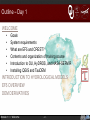
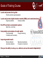
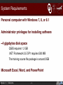
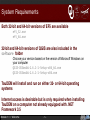
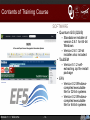
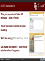
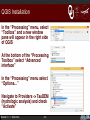
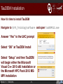
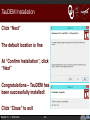
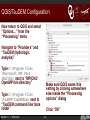
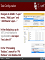
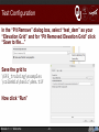
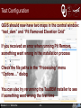
Welcome to EF5 Training University of Oklahoma/HyDROS Module 1.1 Outline – Day 1 WELCOME • • • • • • Goals System requirements What are EF5 and CREST? Contents and organization of training course Introduction to OU, HyDROS, and NASA-SERVIR Installing QGIS and TauDEM INTRODUCTION TO HYDROLOGICAL MODELS EF5 OVERVIEW DEM DERIVATIVES Module 1.1 / Welcome -2- Goals of Training Course Locate and process forcing data Rainfall, potential evapotranspiration Locate and process digital elevation models (DEMs) and create derivatives Diagnose problems Develop workflow Run EF5 and learn customization options Batch files, control files Interpretation and analysis of model results Flood forecasting Confidence and uncertainty Drought monitoring Improving model results Manual calibration Automatic calibration Meaning of parameters Evaluation of model skill Give you the ability to set-up, run, calibrate, and use the model independently! Module 1.1 / Welcome -3- System Requirements Personal computer with Windows 7, 8, or 8.1 Administrator privileges for installing software ~4 gigabytes disk space QGIS requires 1.2 GB .NET Framework 3.5 SP1 requires 500 MB The training course file package is around 2GB Microsoft Excel, Word, and PowerPoint Module 1.1 / Welcome -4- System Requirements Both 32-bit and 64-bit versions of EF5 are available ef5_32.exe ef5_64.exe 32-bit and 64-bit versions of QGIS are also included in the software folder Choose your version based on the version of Microsoft Windows on your computer QGIS-‐OSGeo4W-‐2.6.1-‐1-‐Setup-‐x86_64.exe QGIS-‐OSGeo4W-‐2.6.1-‐1-‐Setup-‐x86.exe TauDEM will install and run on either 32- or 64-bit operating systems Internet access is desirable but is only required when installing TauDEM on a computer not already equipped with .NET Framework 3.5 Module 1.1 / Welcome -5- What are EF5 and CREST? EF5 stands for Ensemble Framework for Flash Flood Forecasting It is scalable to different resolutions EF5 can forecast the entire continuum of floods EF5 is not a single hydrologic model – it is a framework for hydrologic modeling Multiple model cores and physics schemes are possible CREST stands for Coupled Routing and Excess Storage CREST is a hydrologic model developed by NASA (National Aeronautics and Space Administration) and OU (the University of Oklahoma) CREST-like model physics are part of EF5 Module 1.1 / Welcome -6- What are EF5 and CREST? Multi-model ensemble Expandable with new models and physics Multiple solutions à an idea of uncertainty in a forecast User-friendly Cross-platform Windows, Linux, Mac OS X Flexible precipitation inputs TRMM, MRMS, Stage IV Module 1.1 / Welcome -7- Contents of Training Course EXAMPLES DOCUMENTS • • • • Papers about hydrologic modeling EF5 user manual Checklists and instructions for various course components PRESENTATIONS • • • Precipitation/PET forcing HydroSHEDS DEM Module 1.1 / Welcome 16 training modules SOFTWARE DATA • • 7 pre-packaged EF5 examples • • • -8- QGIS 2.6.1 for 64-bit Windows QGIS 2.6.1 for 32-bit Windows TauDEM 5.2 EF5 for 32-bit Windows EF5 for 64-bit Windows Contents of Training Course DATA • PET – Monthly potential evapotranspiration from FewsNET • Precipitation – 3-hrly global precipitation estimates from NASA Tropical Rainfall Measurement Mission • HydroSHEDS – Hydrological data and maps based on shuttle elevation derivatives at multiple scales • Observations – Observed stream flow for training examples Module 1.1 / Welcome -9- Contents of Training Course DOCUMENTS • Workshop Outline • EF5 ReadMe • 6 Quick Guides/Checklists – Installing QGIS and TauDEM – Hydrological Model Evaluation – Processing DEMs and Derivatives – EF5 Control File – EF5 Parameters – Properties of Example Basins • 6 Scientific Papers – CREST physics, DREAM calibration, TRMM precipitation, and examples of CREST in use Module 1.1 / Welcome - 10 - Contents of Training Course EXAMPLES Connecticut Indus Cobb Creek Nzoia Bogota Okavango Module 1.1 / Welcome - 11 - Wang Chu Contents of Training Course PRESENTATIONS PRESENTATIONS • Day 1 • Day 3 – Welcome – Introduction to Hydrological Models – EF5 Overview – DEM Derivatives – DEM Practice – Calibration Practice – Drought – Cobb Creek Example • Day 4 • Day 2 – Connecticut River Example – Bogota River Example – Create Your Own Example (or Indus River Example) – Conclusions and Wrap-Up – Rainfall and PET – Manual Calibration – Automatic Calibration – Interpreting and Using Model Output Module 1.1 / Welcome - 12 - Contents of Training Course SOFTWARE • Quantum GIS (QGIS) – Standalone installer of version 2.6.1 for 64-bit Windows – Version 2.6.1 32-bit installer also included • TauDEM – Version 5.1.2 selfextracting zip file install package • EF5 – Version 0.2 Windowscompiled executable file for 32-bit systems – Version 0.2 Windowscompiled executable file for 64-bit systems Module 1.1 / Welcome - 13 - Introduction to OU Norman, Oklahoma Nearly 30,000 students Home to the National Weather Center (600 meteorologists and hydrologists): National Severe Storms Laboratory School of Meteorology Advanced Radar Research Center Hydrometeorology and Remote Sensing Laboratory (HyDROS) Module 1.1 / Welcome - 14 - HyDROS Laboratory QPE – QUANTITATIVE PRECIPITATION ESTIMATES • Merging satellite, rain gauges, and weather radars • Expertise with PERSIANN, CMORPH, TRMM, MRMS • Improvements to ground radar and satellite estimates 5 scientists and faculty 9 post-docs and visitors 15 graduate students Several dozen alumni From all over the world! Module 1.1 / Welcome HYDROLOGIC MODELING • EF5 • CREST • HyPRO • Data assimilation • Coupling with snow models and landslide models • Global, regional, and local modeling FLASH (FLOODED LOCATIONS AND SIMULATED HYDROGRAPHS) PROJECT • Suite of flash flood forecasting tools in United States • Includes hydrologic models and other rainfall-driven tools - 15 - NASA-SERVIR SERVIR is a joint venture between NASA and USAID (United States Agency for International Development) Satellite-based observation data Science applications Improve environmental decision making in developing nations Centers throughout the world Marshall Space Flight Center in Huntsville, Alabama CATHALAC in Panama RCMRD in Kenya ICIMOD in Nepal Floods, fires, droughts, frost Module 1.1 / Welcome Installing equipment at RCMRD (photo: RCMRD) Satellite image of Lake Victoria basin from EO-1, 2008 (photo: NASA/EO-1) - 16 - QGIS Installation Start by moving your EF5_training folder to your Desktop Navigate to the EF5_training\software folder Select QGIS-‐OSGeo4W-‐2.6.1-‐1-‐Setup-‐x86_64.exe (for computers with 64-bit Windows) Select QGIS-‐OSGeo4W-‐2.6.1-‐1-‐Setup-‐x86.exe (for computers with 32-bit Windows) Answer “Yes” at the prompt à Module 1.1 / Welcome - 17 - QGIS Installation “Welcome to the QGIS Brighton (2.6.1) Setup Wizard” Click “Next” Agree to the license terms – “I Agree” “Choose Install Location” – C: \Program Files\QGIS Brighton is fine – click “Next” “Choose Components” – only install “QGIS” – click “Install” Module 1.1 / Welcome - 18 - QGIS Installation This process should take 2-3 minutes – click “Finish” You’ll now see six icons on your Desktop We’ll be using QGIS Desktop 2.6.1 Go ahead and open it – exit the tip window when it appears 1.1 / Welcome - 19 Module QGIS Installation In the “Processing” menu, select “Toolbox” and a new window pane will appear in the right side of QGIS At the bottom of the “Processing Toolbox” select “Advanced interface” In the “Processing” menu select “Options…” Navigate to Providers -> TauDEM (hydrologic analysis) and check “Activate” Module 1.1 / Welcome - 20 - TauDEM Installation Now it’s time to install TauDEM Navigate to \EF5_Training\software and open TauDEM512.exe Answer “Yes” to the UAC prompt Select “OK” at TauDEM Install Select “Setup” and then TauDEM will begin either the Microsoft Visual C++ 2010 x86 installation or the Microsoft HPC Pack 2012 MSMPI installation 1.1 / Welcome - 21 Module TauDEM Installation If Microsoft Visual Studio has to be installed (if not, skip below to the HPC Pack 2012 installation): Click “Setup” and then accept the license terms Click “Install” and then “Finish” The Microsoft HPC Pack 2012 installer will automatically pop up: Click “Next” and the accept the license terms The default location is fine Click “Install” Module 1.1 / Welcome - 22 - TauDEM Installation Now you may need to install the .NET Framework version 3.5 If you get this dialog box, click “Yes” Otherwise, skip ahead to Slide 28 Select .NET Framework 3.5 SP1 on the website that pops up Module 1.1 / Welcome - 23 - .NET Framework 3.5 Installation Click the red “Download” button Then click “No thanks and continue” Module 1.1 / Welcome - 24 - .NET Framework 3.5 Installation Click the boxed link (at right) à Then click “Run” at the bottom of the browser window Module 1.1 / Welcome - 25 - .NET Framework 3.5 Installation At the “Windows Features” pop-up, click “Download and install this feature” Module 1.1 / Welcome - 26 - .NET Framework 3.5 Installation Windows will download the required files (this process may take a significant amount of time, depending on your internet connection) Then click “Close” à Reopen TauDEM512.exe Module 1.1 / Welcome - 27 - TauDEM Installation Click “Next” The default location is fine At “Confirm Installation”, click “Next” Congratulations – TauDEM has been successfully installed! Click “Close” to exit Module 1.1 / Welcome - 28 - QGIS/TauDEM Configuration Now return to QGIS and select “Options…” from the “Processing” menu Navigate to “Providers” and “TauDEM (hydrologic analysis)” Type C:\Program Files \Microsoft HPC Pack 2012\Bin next to “MPICH2/ OpenMPI bin directory” Type C:\Program Files \TauDEM\TauDEM5Exe next to “TauDEM command line tools folder” Module 1.1 / Welcome Make sure QGIS saves this setting by clicking somewhere else inside the “Processing options” dialog Click “OK” - 29 - Test Configuration Navigate to QGIS’s “Layer” menu, “Add Layer” and “Add Raster Layer…” In the dialog box, go to \EF5_training\data \HydroSHEDS and open “test_dem.tif” In the “Processing Toolbox”, search for “Pit Remove” and double-click Module 1.1 / Welcome - 30 - Test Configuration In the “Pit Remove” dialog box, select “test_dem” as your “Elevation Grid” and for “Pit Removed Elevation Grid” click “Save to file…” Save the grid to \EF5_training\examples \colombia\basic\dem.tif Now click “Run” Module 1.1 / Welcome - 31 - Test Configuration QGIS should now have two maps in the central window: “test_dem” and “Pit Removed Elevation Grid” If you received an error when running Pit Remove, something went wrong in the installation process Check the file paths in the “Processing” menu “Options…” dialog You can also try rerunning the TauDEM installer to see if something went wrong the first time Module 1.1 / Welcome - 32 - Why QGIS and TauDEM? QGIS is flexible • • • Literally thousands of available plug-ins exist QGIS runs on Windows, Mac, Linux, and other systems ArcGIS runs only on Windows QGIS is free and open-source • • • It costs you nothing and has a community of thousands of users and supporters Commercial solutions like Esri’s ArcGIS cost thousands of dollars per workstation Commercial support for QGIS is available from third parties QGIS is licensed under the Creative Commons Attribution-ShareAlike 3.0 license. www.qgis.org TauDEM was developed by David Tarboton of Utah State University with support from the US Army Corps of Engineers System Wide Water Resources Program. TauDEM is available under the terms of GNU General Public License v2. hydrology.usu.edu/taudem/taudem5/index.html Module 1.1 / Welcome - 33 - Coming Up…. The next module is INTRODUCTION TO HYDROLOGICAL MODELS You can find it in your \EF5_training\presentations directory Module 1.1 References EF5 Training Doc 1 – Installation of QGIS and TauDEM, (March 2015). Module 1.1 / Welcome - 34 -