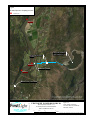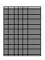
1
Relicensing Study 3.2.1 WATER QUALITY MONITORING STUDY Initial Study Report Summary Northfield Mountain Pumped Storage Project (No. 2485) and Turners Falls Hydroelectric Project (No. 1889) Prepared for: Prepared by: SEPTEMBER 2014 Northfield Mountain Pumped Storage Project (No. 2485) and Turners Falls Hydroelectric Project (No. 1889) INITIAL STUDY REPORT SUMMARY – RELICENSING STUDY 3.2.1 1.1 Study Summary The purpose of this study is to characterize baseline water quality [water temperature, dissolved oxygen (DO)] conditions in the Turners Falls Impoundment (Impoundment), bypass reach, power canal and in the Connecticut River below Cabot Station. The field work for this study will occur in 2015. Task 1 of the study is to develop a Field Sampling Plan. This plan was developed in consultation with stakeholders and includes the additional monitoring for water temperature below the Turners Falls Project. 1.2 Study Progress Summary Task 1: Develop Sampling Plan In the Federal Energy Regulatory Commission’s (FERC) February 21, 2014 Study Plan Determination Letter (SPDL), it states “We recommend FirstLight develop a temperature monitoring study plan for the reach between Cabot Station and the Holyoke dam to describe temperature and temperature rate of change associated with peaking operations. The plan should be developed in consultation with interested stakeholders and file for Commission approval with the Initial Study Report in September 2014”. FirstLight emailed the Water Quality Monitoring Study Field Sampling Plan on June 30, 2014 to the United States Fish and Wildlife Service (USFWS), National Marine Fisheries Service (NMFS), Massachusetts Department of Environmental Protection (MADEP), New Hampshire Department of Environmental Services (NHDES), Vermont Agency of Natural Resources (VANR), Massachusetts Division of Fish and Wildlife (MDFW), Connecticut River Watershed Council (CRWC), Trout Unlimited (TU), The Nature Conservancy (TNC), Landowners and Concerned Citizens for License Compliance (LCCLC), Franklin Regional Council of Governments (FRCOG) and Karl Meyer and requested written comments be provided by July 28, 2014. Through September 5, 2014, comments were received from the following entities: MADEP Division of Watershed Management CRWC MDFW (Natural Heritage and Endangered Species Program, NHESP) The Field Sampling Plan has been revised to address the comments and is attached as Appendix A; the comment letters and a responsiveness summary is also appended to the revised Field Sampling Plan. Task 2: Dissolved Oxygen and Temperature Monitoring Field work to occur in 2015. Task 3: DO and Temperature Profiles Field work to occur in 2015. Task 4: Data Analysis & Report A final report will be completed in March 2016 per FERC’s SPDL. 1.3 Variances from Study Plan and Schedule To date, there are no variances from the study plan. 1 Northfield Mountain Pumped Storage Project (No. 2485) and Turners Falls Hydroelectric Project (No. 1889) INITIAL STUDY REPORT SUMMARY – RELICENSING STUDY 3.2.1 1.4 Remaining Activities Tasks 2-4 are slated to occur in 2015. 2 Northfield Mountain Pumped Storage Project (No. 2485) and Turners Falls Hydroelectric Project (No. 1889) INITIAL STUDY REPORT SUMMARY – RELICENSING STUDY 3.2.1 Appendix A Water Quality Field Sampling Plan 3 Northfield Mountain Pumped Storage Project (No. 2485) and Turners Falls Hydroelectric Project (No. 1889) RELICENSING STUDY 3.2.1 WATER QUALITY MONITORING STUDY FIELD SAMPLING PLAN Filed with Initial Study Report - September 2014 Copyright © 2014 FirstLight Power Resources. All Rights Reserved. Northfield Mountain Pumped Storage Project (No. 2485) and Turners Falls Hydroelectric Project (No. 1889) WATER QUALITY MONITORING STUDY FIELD SAMPLING PLAN Table of Contents 1.0 Introduction ....................................................................................................................................... 1 2.0 Study Goals and Objectives .............................................................................................................. 1 3.0 Study Locations ................................................................................................................................ 1 4.0 Methodology for Continuous Dissolved Oxygen and Temperature Data Collection ....................... 3 5.0 Methodology for Dissolved Oxygen and Temperature Profile Data Collection ............................... 4 6.0 Methodology for Continuous Temperature Data Collection............................................................. 5 7.0 Data Management and Reporting ..................................................................................................... 6 7.1 Data Management ......................................................................................................................... 6 7.2 Data Review .................................................................................................................................. 6 7.3 Reporting....................................................................................................................................... 6 8.0 Schedule and Consultation ................................................................................................................ 6 9.0 Literature Cited ................................................................................................................................. 8 List of Tables Table 3.1: Water Quality Monitoring Sampling Locations. ........................................................................ 9 Table 4.1: Water Quality Monitoring Instrument Specifications. .............................................................. 10 List of Figures Figure 3.l: Overview of DO and Water Temperature Sampling Locations. .............................................. 11 Figure 3.2: Water Quality Sampling Locations Near Turners Falls Dam. ................................................. 12 Figure 3.3: Water Quality Sampling Locations Near the Northfield Mountain Tailrace........................... 13 Figure 3.4: Turners Falls Impoundment Vertical Profile Locations. ......................................................... 14 Figure 3.5: Continuous Water Temperature Monitoring Locations from Cabot Station to the Holyoke Dam. ............................................................................................................................................................ 15 Appendices Appendix A: MA DEP Water Quality Sampling Standard Operating Procedures ..................................... 16 Appendix B: Example Temperature and DO Profile Field Data Sheet....................................................... 18 Appendix C: Responsiveness Summary and Stakeholder Comment Letters .............................................. 20 ___________________________________________________________________________________ i Northfield Mountain Pumped Storage Project (No. 2485) and Turners Falls Hydroelectric Project (No. 1889) WATER QUALITY MONITORING STUDY FIELD SAMPLING PLAN 1.0 Introduction FirstLight Hydro Generating Company (FirstLight) initiated the relicensing of its 1,119.2 MW Northfield Mountain Pumped Storage Project (FERC No. 2485) and 67.09 MW Turners Falls Hydroelectric Project (FERC No. 1889) with the Federal Energy Regulatory Commission (FERC or Commission). The Projects are located on the Connecticut River in the towns of Northfield, MA (River Mile (RM) 127.2) and Turners Falls, MA (RM 122), respectively. In accordance with the relicensing process, multiple stakeholders requested FirstLight to conduct a water quality monitoring study to determine the effect of Project operations on water quality of the Connecticut River within the Turners Falls Impoundment (Impoundment), bypass reach, power canal, and the Cabot Station tailrace reach. FirstLight filed a Revised Study Plan (RSP) on August 14, 2013 with FERC. Study 3.2.1 contained the plan for conducting the Water Quality Monitoring Study. FERC issued its Study Plan Determination Letter (SPDL) for the aquatic studies on February 21, 2014, approving the Water Quality Monitoring Study Plan with certain modifications. The primary modification required that FirstLight develop a study plan component for temperature monitoring of the Connecticut River between Cabot Station and the Holyoke Dam to describe temperature and temperature rate of change associated with peaking operations. Task 1 of the RSP requires that FirstLight develop a sampling plan in consultation with interested stakeholders prior to sampling. The methods described in this plan were developed based on the FERCapproved RSP, as modified, and standard operating procedures provided by the Massachusetts Department of Environmental Protection (MADEP) which are included in Appendix A to this plan. 2.0 Study Goals and Objectives The purpose of this field sampling plan is to provide a detailed description of the water quality and temperature monitoring protocols, procedures, data quality control, and reporting that will be conducted. The results of this study will provide information sufficient to enable agencies and stakeholders to understand water quality conditions and dynamics within the Project area and downstream to the Holyoke Dam. The specific objectives of the study are to: Characterize water temperature and dissolved oxygen (DO) conditions within the Turners Falls Impoundment, bypass channel, power canal, and below Cabot Station; Determine potential impacts of the Turners Falls Project and Northfield Mountain Project on water temperature and DO; Compare collected data with applicable State water quality standards; Describe water temperature and temperature rate of change between Cabot Station and the Holyoke Dam. 3.0 Study Locations The RSP contained 11 sampling stations from below Vernon Dam to downstream of Cabot Station. Seven additional temperature monitoring locations from below Cabot Station downstream to the Holyoke ___________________________________________________________________________________ 1 Northfield Mountain Pumped Storage Project (No. 2485) and Turners Falls Hydroelectric Project (No. 1889) WATER QUALITY MONITORING STUDY FIELD SAMPLING PLAN Dam have been added to this plan for a total of 18 sampling locations (Table 3.1). Continuous temperature and DO will be measured and recorded at nine locations within the project area, listed below and shown in Figure 3.1, Figure 3.2 and Figure 3.3. Below the Vernon Dam and Ashuelot River confluence Above the Northfield Mountain tailrace Northfield Mountain tailrace Below the Northfield Mountain tailrace Upstream of the Turners Falls Dam at boat barrier Bypass reach upstream of Station No. 1 Bypass reach upstream of Rock Dam Turners Falls Power Canal Below Cabot Station tailrace DO and temperature profiles will be collected at three relatively deep locations within the Impoundment (Figure 3.4), listed below. Upstream of the Turners Falls Dam at boat barrier (same location at continuous monitoring site) Approximately 3.0 mi upstream of the Turners Falls Dam, at the deepest known area within the impoundment. Approximately 4 miles upstream of the MA Route 10 Bridge. In addition, continuous temperature data will be collected at seven locations downstream of Cabot Station to the Holyoke Dam (Figure 3.5). The locations were selected with input from the Connecticut River Watershed Council (CRWC) and MA Natural Heritage and Endangered Species Program (NHESP). The proposed locations of the temperature monitoring stations are listed below. Downstream of the Deerfield River confluence Second Island, Sunderland, MA Third Island, Sunderland, MA Sandbar above Mill River, Hadley, MA Sandbar below Mill River, Hadley, MA Side channel at Elwell Island, Hadley, MA ___________________________________________________________________________________ 2 Northfield Mountain Pumped Storage Project (No. 2485) and Turners Falls Hydroelectric Project (No. 1889) WATER QUALITY MONITORING STUDY FIELD SAMPLING PLAN Near Mitch’s Island, Hadley, MA 4.0 Methodology for Continuous Dissolved Oxygen and Temperature Data Collection Equipment Continuous temperature and DO monitoring will be conducted using HOBO DO Loggers (Model U26001), which also records temperature. The HOBO DO Loggers are ideal for long-term deployment (>10 days) because it is equipped with an optical sensor to measure DO, which is more resistant to biofouling than membrane sensors, and can last up to six-months after initialization. The logger has an operating temperature and DO range of -5 to 40°C and 0 to 30 mg/L, respectively. Specifications for the sampling equipment proposed for this study are provided in Table 4.1. In order to collect DO as percent saturation (in addition to mg/L) the HOBO loggers require barometric pressure (BP) data. BP data will be continuously collected over the course of the study using a HOBO Water Level Logger (Model U20-001-04) as recommended by the manufacturer. Onset documentation specifies that the loggers operate between a pressure range of 0 to 145 kPa (0 to 21 psia) with a raw pressure accuracy of 0.3%. The BP sensor will be installed in the air in a secure location in the vicinity of the sampling sites for the study duration. Calibration The HOBO DO Loggers will be calibrated prior to deployment using the Lab Calibration tool found in the manufacturer’s software. The loggers will need to be calibrated before deployment or after replacing an expired sensor cap. Sensor caps expire approximately 7 months after initialization. The Lab Calibration tool sets the gain and offset adjustment for the logger by: 1) restoring logger calibration values to factory defaults; 2) using your own gain and offset adjustment values; or 3) calculating the values with a three-step calibration procedure. If the three-step calibration procedure is chosen, the logger is first calibrated to 100% saturation by placing it in water-saturated air. Following this, the logger is then calibrated to 0% saturation by placing it in sodium sulfite or another 0% oxygen environment. The manufacturer recommends 0% saturation calibration only if the logger will be deployed in waters with possible DO levels ≤ 4 mg/L. These loggers will be tested in a common bath before deployment to ensure they are collecting data and similar measurements (MADEP, 2009). All pre-deployment calibrations will be performed in the laboratory (MADEP, 2007). In addition, a hand-held thermometer traceable to a NIST-certified thermometer will be used to check sensor accuracy; checks will be made prior to deployment, monthly, and at retrieval. It may be necessary, and recommended by the manufacturer (Onset® Computer Corporation), to take DO field calibration readings if biofouling is present or likely to occur. Field calibration readings will be conducted following the manufacturers recommendations, which include: using another calibrated DO meter to obtain replicate DO measurements, downloading data from the logger, cleaning the sensor, and taking another field calibration reading. The DO readings will then be corrected using the field calibration readings and the manufacturer’s software, HOBO DO Assistant, which compensates for any measurement drift due to biofouling (i.e., correction of the DO measurements occurs post hoc). Field Sampling Specifications Temperature (°C) and DO (mg/L) will be recorded in situ every 15 minutes at the nine locations identified above. Water temperature at the nine locations will be recorded from April 1 through November 15, while DO will be recorded during the summer low-flow, high temperature period from June 1 through September 30. Deployment of the continuous temperature and DO data loggers will generally follow ___________________________________________________________________________________ 3 Northfield Mountain Pumped Storage Project (No. 2485) and Turners Falls Hydroelectric Project (No. 1889) WATER QUALITY MONITORING STUDY FIELD SAMPLING PLAN procedures employed by the MADEP, Division of Watershed Management Standard Operating Procedure of Multiprobe Deployment (MADEP, 2007). Five of the nine locations will be in the Impoundment (Figure 3.1). Each of these data loggers will be deployed in a representative location at a minimum of 4 ft from the surface, but not deeper than 25% depth. To confirm representativeness, periodic measurements of surface, logger depth and near bottom will occur. The remaining continuous temperature and DO data loggers will be deployed in the bypass reach, power canal, and below Cabot Station (Figure 3.2). Loggers at these locations will be placed in a representative location in mid-channel or thalweg at mid-depth, or just off the bottom depending on site-specific characteristics. Installation locations will be selected that are low risk for vandalism and will be as unobtrusive as possible to minimize conflicts with recreational use of the river. Areas of low water velocities (~< 1 fps) and significant turbulence will be avoided to the extent possible (MADEP, 2007). All loggers will be encased in perforated pipe, and attached to an immovable object or anchor using polypropylene rope or cable (MADEP, 2009). Bi-weekly site visits (i.e., once every two weeks) will occur to periodically inspect the loggers for biofouling, download data, and obtain replicate temperature and DO measurements for quality assurance/quality control (QA/QC) purposes. Data will be downloaded from the loggers on a bi-weekly basis to assure the logger is functioning correctly over the long deployment duration. GPS coordinates and photo documentation will be obtained of each location; and weather, river flow, and condition of the logger and battery life will be recorded in a field notebook during deployment, bi-weekly sampling, and retrieval. 5.0 Methodology for Dissolved Oxygen and Temperature Profile Data Collection Equipment The temperature and DO profiles will be collected using a portable handheld YSI ProODO meter equipped with a 50 m cable. The meter provides temperature (°C), DO (mg/L; % saturation), and BP (mmHg) readings. The YSI ProODO meter has an operating range of -5 to 70°C and 0 to 50 mg/L. Additional specifications for the YSI ProODO meter are provided in Table 4.1. Calibration A one-point calibration (water saturated air) will be conducted at the beginning (prior to sampling) and end (following all sampling) of each sample day. Calibration will follow the instructions described in the YSI ProODO manual. Calibration results will be saved on the logger and recorded on the applicable field data sheet (Appendix B). In addition, a hand-held thermometer traceable to a NIST-certified thermometer will be used to check sensor accuracy; checks will be made prior to deployment, monthly, and at retrieval. Field Sampling Specifications Temperature (°C) and DO (mg/L; % saturation) profiles will be collected on a bi-weekly basis at the locations described above to characterize the temperature and DO profile and timing of stratification within the Impoundment. The bi-weekly sampling will be conducted concurrently with the other water quality monitoring beginning April 1 through November 15, 2015. Profile sampling will generally follow procedures employed by the MADEP, Division of Watershed Management Standard Operating Procedure for Lake Sampling (MADEP, 2010) and Water Quality Multiprobe Data Collection (MADEP, 2005). ___________________________________________________________________________________ 4 Northfield Mountain Pumped Storage Project (No. 2485) and Turners Falls Hydroelectric Project (No. 1889) WATER QUALITY MONITORING STUDY FIELD SAMPLING PLAN Vertical profile sampling will occur at a consistent time across sampling events and as early in the morning as possible. GPS coordinates and photo documentation will be obtained of each location. Prior to taking the temperature and DO profile, the boat will be anchored with the bow facing upwind or upstream. When the boat becomes stabilized a portable depth sounder will be used to obtain a depth measurement. Starting at the surface, measurements of temperature and DO will be collected at 1.0 m depth increments1; the last measurement will be 0.5 m above bottom, but only if the primary user is certain the probe did not make contact with the bottom (MADEP, 2005). Measurements will only be recorded after waiting at least 30 seconds at each depth interval to allow the instrument to stabilize. Only after the instrument is stabilized will a reading be recorded and the probe lowered to the next interval. At least one replicate measurement at a random depth interval will also be measured. All data along with the approximate locations of the strata (epi-, meta-, and hypolimnia) and depth of the thermocline will be recorded on the field data sheets (MADEP, 2005). An example field data sheet is provided in Appendix B. Replicate measurements will also be collected at least once per vertical profile, or after every twentieth measurement at a random depth interval. If the profile appears to be stratified, replicate measurements within the metalimnion (thermocline) will be avoided because temperature and DO gradients can express subtle changes in relation to depth in this layer of the impoundment. All replicate measurements will be recorded manually. 6.0 Methodology for Continuous Temperature Data Collection Equipment Continuous temperature data collected from Cabot Station to the Holyoke Dam will be collected using HOBO Water Temperature Pro v2 Data Loggers (Model U22-001). This logger has an operating range of -40 to 70°C. Specifications for the HOBO Water Temperature Pro v 2 Data Loggers are provided in Table 4.1. Calibration The HOBO Water Temperature Pro v2 Data Loggers (Model U22-001) are factory calibrated; therefore, no calibration is necessary. However, the loggers will be tested in a common bath prior to deployment to ensure they are functioning properly and that their measurements are similar (within± 0.5°C) (MADEP, 2009). In addition, a hand-held thermometer traceable to a NIST-certified thermometer will be used to check sensor accuracy; checks will be made prior to deployment, monthly, and at retrieval. Field Sampling Specifications Water temperature (°C) of the Connecticut River will be continuously monitored in situ every 15-minutes at five locations from Cabot Station to the Holyoke Dam from April 1 through November 15. Deployment of the continuous temperature loggers will generally follow procedures employed by the MADEP, Division of Watershed Management Standard Operating Procedure of Continuous Temperature Monitoring using Temperature-only Loggers (MADEP, 2009). Each logger will be deployed at a representative location, and at a sufficient distance downstream of the mixing zone of any significant tributaries of the Connecticut River, such as the Deerfield and Fort Rivers. 1 Because Station No. 6 is extremely deep, the vertical profile measurement intervals will be collected every 1.0 meter starting at the surface, until a homothermous condition is encountered in the hypolimnion. ___________________________________________________________________________________ 5 Northfield Mountain Pumped Storage Project (No. 2485) and Turners Falls Hydroelectric Project (No. 1889) WATER QUALITY MONITORING STUDY FIELD SAMPLING PLAN The loggers will be encased in perforated protective housing, and secured off the bottom of the river with rocks or concrete blocks. The logger assembly will be tethered to an immovable object on shore with polypropylene rope or cable. Periodic site visits will occur to inspect the meters, download data, and obtain replicate temperature measurements for QA/QC purposes. Replicate measurements will be collected adjacent to each continuous data logger during each site visit using a separate meter. Data will be downloaded from the loggers to assure the logger is functioning correctly over the long deployment duration. GPS coordinates and photo documentation will be obtained of each location; and the condition of the logger will be recorded in a field notebook during each site visit. 7.0 Data Management and Reporting 7.1 Data Management All temperature and DO measurements collected at the three, vertical profiles will be recorded in a field notebook or on field data sheets on the day of sampling. Data will include DO and water temperature measurements, general weather and flow conditions, and QA/QC data records. Continuous temperature and DO data collected using the HOBO data loggers will be stored on the logger’s memory and downloaded during each bi-weekly sampling event, and again at the end of the study period. Hourly operations data regarding the Impoundment elevation, periods of pumping, generating, or idle, discharge over Turners Falls Dam, and natural routed flow will be provided by FirstLight. 7.2 Data Review All field-collected data will undergo a thorough QA/QC review process to ensure accuracy and completeness of the dataset. Adherence to standard methods and QA/QC procedures for all water quality monitoring helps ensure that the resulting data will be accurate, precise, comparable, and representative. Data will be reviewed at the end of each day (vertical profiles) or periodically throughout (continuous data) the course of the study. All continuous water quality data will be analyzed for outliers or other aberrant data points. DO data collected from the continuous loggers will be corrected, as necessary, using the field calibration/replicate DO readings. The HOBOware DO Assistant corrects the DO values as a result from measurement drift due to biofouling. This correction process will only be performed if biofouling on the logger is believed to compromise the measurements or the readings from the loggers are not within the measurement error of the replicate data. 7.3 Reporting At the conclusion of the study and following QA/QC of the data, results and findings will be summarized in a final report. The final report will be submitted to FERC as part of the Integrated Licensing Process (ILP) schedule. All water quality data collected as part of this study will be submitted to the regulatory agencies in an electronic format that can be automatically uploaded to their respective databases. 8.0 Schedule and Consultation Per FERC’s SPDL for the aquatic studies, this plan is to be developed in consultation with interested stakeholders and specific approval is required from MADEP, USFWS and NHDES. A draft of this plan was submitted to interested stakeholders on June 27, 2014. Comments were received from MADEP, CRWC, and the MA NHESP. ___________________________________________________________________________________ 6 Northfield Mountain Pumped Storage Project (No. 2485) and Turners Falls Hydroelectric Project (No. 1889) WATER QUALITY MONITORING STUDY FIELD SAMPLING PLAN This sampling plan has been revised to address the comments received. Table 1 in Appendix C provides a summary of how the comments were addressed. Copies of the comment letters received are included in Appendix C. Once the plan is approved by FERC, the field study will be implemented between April and November 2015. Continuous DO data will be collected during the summer low-flow, high temperature period starting on June 1 (continuous temperature data collection will commence on April 1). As requested by MADEP, data through June 30 will be provided to MADEP along with the corresponding vertical profile data. FirstLight will then consult with MADEP to determine if early morning vertical profile collection is justified. If so, FirstLight will adjust the time of data collection, as directed by MADEP and as impoundment travel time constraints and safety considerations allow for. ___________________________________________________________________________________ 7 Northfield Mountain Pumped Storage Project (No. 2485) and Turners Falls Hydroelectric Project (No. 1889) WATER QUALITY MONITORING STUDY FIELD SAMPLING PLAN 9.0 Literature Cited Massachusetts Department of Environmental Protection (MADEP). 2013. 314 CMR 4.0: Massachusetts Surface Water Quality Standards. Massachusetts Department of Environmental Protect, Division of Water Pollution Control. December 2013. < http://www.mass.gov/eea/docs/dep/service/ regulations/314cmr04.pdf>. Accessed March 12, 2014. Massachusetts Department of Environmental Protection (MADEP). 2010. Standard Operation Procedure: Lake Sampling. Massachusetts Department of Environmental Protection, Division of Watershed Management. January 2010. CN 151.0. 21 pp. Massachusetts Department of Environmental Protection (MADEP). 2009. Standard Operation Procedure: Continuous Temperature Monitoring using Temperature-only Loggers. Massachusetts Department of Environmental Protection, Division of Watershed Management. May 2009. CN 103.1. 19 pp. Massachusetts Department of Environmental Protection (MADEP). 2007. Standard Operation Procedure: Multi-Probe Sonde Deployments for Continuous Unattended Water Quality Data Collection. Massachusetts Department of Environmental Protection, Division of Watershed Management. June 2007. CN 4.41. 17 pp. Massachusetts Department of Environmental Protection (MADEP). 2005. Standard Operation Procedure: Water Quality Multiprobe Data Collection. Massachusetts Department of Environmental Protection, Division of Watershed Management. September 2005. CN 4.21. 46 pp. United States Geological Survey (USGS). 2006. Guidelines and Standard Procedures for Continuous Water-quality Monitors: Station Operation, Record Computation, and Data Reporting. Techniques and Methods Report: 1-D3. 96 pp. ___________________________________________________________________________________ 8 Northfield Mountain Pumped Storage Project (No. 2485) and Turners Falls Hydroelectric Project (No. 1889) WATER QUALITY MONITORING STUDY FIELD SAMPLING PLAN Table 3.1: Water Quality Monitoring Sampling Locations. Station No. Type Location Comments Connecticut River- Turners Falls Impoundment (Temperature and DO) 1 Continuous Below the Vernon Dam and Ashuelot River Confluence Near thalweg at 25% depth 2 Profile Deep area upstream of Northfield Mountain Collect profile at one meter depth increments 3 Continuous Above the Northfield Mountain Discharge; Downstream of Kidds Island Near thalweg at 25% depth 4 Continuous Northfield Mountain Tailrace Within the Northfield Mountain Tailrace at 25% depth 5 Continuous Below the Northfield Mountain Tailrace; Upstream of Millers River Confluence Near thalweg at 25% depth 6 Profile Deepest area of Turners Falls Impoundment 7 Profile and Continuous Upstream of the Turners Falls Dam at Boat Barrier Collect profile at one meter depth increments until homothermous hypolimnion is encountered Collect profile at one meter depth increments and install continuous meter at 25% depth Connecticut River- Bypass Reach (Temperature and DO) 8 Continuous Upstream of Station No. 1 Mid-channel, mid-depth 9 Continuous Upstream of Rock Dam; west channel at Rawson Island. Mid-channel, mid-depth Turners Falls Power Canal (Temperature and DO) 10 Continuous At the 11th Street Bridge Mid-channel, mid-depth Connecticut River- Below Cabot Station (Temperature and DO) 11 Continuous Below the Cabot Station tailrace, upstream of Deerfield River confluence Thalweg, mid-depth. Connecticut River- Cabot Station to Holyoke Dam (Temperature) 12 Continuous Downstream of the Deerfield River confluence 13 Continuous Third Island 14 Continuous Second Island, near shore of island. 15 Continuous Submerged shallow sandbar 16 Continuous Submerged shallow sandbar 17 Continuous River right channel at Elwell Island 18 Continuous Upstream of Mt. Tom Station, near Mitch’s Island Anchored near bottom, near shore Anchored near bottom, near shore of island Anchored near bottom, near shore of island Anchored near bottom, at sandbar Anchored near bottom, at sandbar Anchored near bottom, near shore Anchored near bottom, near shore ___________________________________________________________________________________ 9 Northfield Mountain Pumped Storage Project (No. 2485) and Turners Falls Hydroelectric Project (No. 1889) WATER QUALITY MONITORING STUDY FIELD SAMPLING PLAN Table 4.1: Water Quality Monitoring Instrument Specifications. Parameter Specification Description ® HOBO Dissolved Oxygen Logger (U26-001) Dissolved Oxygen (mg/L) Temperature (°C) Sensor type Optical (dynamic luminescence quenching) Operating Range 0 to 30 mg/L Calibrated Range 0 to 20 mg/L (0 to 35°C) Accuracy 0.2 mg/L up to 8 mg/L; 0.5 mg/L from 8 to 20 mg/L Resolution 0.02 mg/L Sensor Life 6 months Operating Range -5 to 40°C Accuracy 0.2°C Resolution 0.02°C Depth Rating ― 100 m Battery Life ― 3 years at 5-minute logging intervals YSI ProODO Dissolved Oxygen (mg/L) Dissolved Oxygen (% saturation) Temperature (°C) Barometer (mmHg) Sensor type Optical (dynamic luminescence quenching) Range Resolution 0 to 50 mg/L ± 0.1 mg/L (0 to 20 mg/L) or 1% of reading; ± 10% of reading (20 to 50 mg/L) 0.01 or 0.1 mg/L (autoscaling) Sensor type Optical (dynamic luminescence quenching) Range Resolution 0 to 500% air saturation ±1% 1% of reading (0 to 200% air saturation) or ± 10% (200 to 500% air saturation) 0.1% air saturation Range -5 to 70°C Accuracy ±0.2°C Resolution 0.1°C Range 375 to 825 mmHg Accuracy ±1.5 mmHg (0 to 50°C) Resolution 0.1 mmHg Accuracy Accuracy ― Cable Length 50 m ® HOBO Water Temp Pro v2 (U22-001) Temperature (°C) Range -40 to 70°C in air; 50°C maximum in water Accuracy ±0.21°C (o to 50°C) Resolution 0.02°C at 25°C Battery Life ― 6 years at 1-minute logging intervals Depth Rating ― 120 m ___________________________________________________________________________________ 10 Legend Project Boundary State Boundary Ashuelot River DO and Temperature Sampling Locations ! ( # * ! U Continuous Profile ! ( Profile and Continuous Station 1 Vernon Dam # * VERMONT Station 2 NEW HAMPSHIRE MASSACHUSETTS MASSACHUSETTS Route 10 Bridge ! ( Northfield Mountain Upper Reservoir Station 3 Fall River Turners Falls Dam ! U ! Station 7 ! ( ! Station 10 ( Station 8 ( # * ! ( Station 4 ! ( Station 5 Station 6 Station 9 Cabot Station ! ( Station 11 Millers River Deerfield River Service Layer Credits: Source: Esri, DigitalGlobe, GeoEye, i-cubed, Earthstar Geographics, CNES/Airbus DS, USDA, USGS, AEX, Getmapping, Aerogrid, ³ FIRSTLIGHT POWER RESOURCES RELICENSING STUDY 3.2.1 WATER QUALITY MONITORING FIELD SAMPLING PLAN 0 0.75 1.5 Figure 3.1: Overview of DO and Water Temperature Sampling Locations 3 Miles Copyright © 2014 FirstLight Power Resources All rights reserved. Path: W:\gis\studies\3_2_1\maps\Figure 3.1.mxd Legend DO and Temperature Sampling Locations ! ( ! U Continuous Fall River Confluence Profile and Continuous Turners Falls Dam ! ( Station 8 ! U Bypass Reach Station 7 Station No. 1 ! ( Station 10 ! ( Station 9 Power Canal Cabot Station ! ( Station 11 Deerfield River Confluence Service Layer Credits: Source: Esri, DigitalGlobe, GeoEye, i-cubed, Earthstar Geographics, CNES/Airbus DS, USDA, USGS, AEX, Getmapping, Aerogrid, ³ FIRSTLIGHT POWER RESOURCES RELICENSING STUDY 3.2.1 WATER QUALITY MONITORING FIELD SAMPLING PLAN 0 0.25 0.5 Figure 3.2: Water Quality Sampling Locations Near Turners Falls Dam 1 Miles Copyright © 2014 FirstLight Power Resources All rights reserved. Path: W:\gis\studies\3_2_1\maps\Figure 3.2.mxd Legend DO and Temperature Sampling Locations ! ( Continuous ! ( Station 3 Northfield Mountain Upper Reservoir Northfield Mountain Tunnel ! ( Station 4 Northfield Tailrace ! ( Station 5 Millers River Confluence Service Layer Credits: Source: Esri, DigitalGlobe, GeoEye, i-cubed, Earthstar Geographics, CNES/Airbus DS, USDA, USGS, AEX, Getmapping, Aerogrid, ³ FIRSTLIGHT POWER RESOURCES RELICENSING STUDY 3.2.1 WATER QUALITY MONITORING FIELD SAMPLING PLAN 0 0.25 0.5 Figure 3.3: Water Quality Sampling Locations Near the Northfield Mountain Tailrace 1 Miles Copyright © 2014 FirstLight Power Resources All rights reserved. Path: W:\gis\studies\3_2_1\maps\Figure 3.3.mxd # * Station 2 # * Station 2 Extent 1 Turners Falls Dam ! U Station 7 Route 10 Bridge (Bennett's Meadow Bridge) # * Station 6 Extent 2 Extent 1 0 0.5 1 Miles Turners Falls Dam ! U Location of Station 6 Vertical Temperature and DO Profile Station 7 Barton Cove # * Station 6 Legend DO and Temperature Sampling Locations # * ! U Profile Profile and Continuous Legend Service Layer Credits: Source: Esri, DigitalGlobe, GeoEye, i-cubed, Earthstar Geographics, CNES/Airbus DS, USDA, USGS, AEX, Getmapping, Aerogrid, IGN, IGP, swisstopo, and the Extent 2 0 ³ FIRSTLIGHT POWER RESOURCES RELICENSING STUDY 3.2.1 WATER QUALITY MONITORING FIELD SAMPLING PLAN 1,000 2,000 Feet Figure 3.4: Turners Falls Impoundment Vertical Profile Locations Copyright © 2013 FirstLight Power Resources All rights reserved. Path: W:\gis\studies\3_2_1\maps\Figure 3.4.mxd Legend Temperature Sampling Locations W X Revised Locations Cabot Station ! Initially Proposed ! ! ( Station 12, Downstream of Deerfield River W X Deerfield River Confluence ! ! ( Station 13, Third Island Downstream of Deerfield River X W W X Station 14, Second Island Route 116 Bridge Sunderland, MA ! ! ( Station 15 , Submerged Sandbar X W W X Station 16, Submerged Sandbar Station 17, Elwell Island Rt. 9 Bridge Hadley, MA W X The Oxbow Northampton, MA Fort River Confluence ! ! ! ( ! ( Mitch's Marina Hadley, MA ! W X ! Station 18, Upstream of Mt. Tom near Mitch's Island ! Manhan River Confluence ! ! ( Brunelle's Marina South Hadley, MA ! Holyoke Dam Service Layer Credits: Source: Esri, DigitalGlobe, GeoEye, i-cubed, Earthstar Geographics, CNES/Airbus DS, USDA, USGS, AEX, Getmapping, Aerogrid, ³ FIRSTLIGHT POWER RESOURCES RELICENSING STUDY 3.2.1 WATER QUALITY MONITORING FIELD SAMPLING PLAN 0 1.25 2.5 Figure 3.5 Continuous Water Temperature Monitoring Locations Cabot Station to Holyoke Dam (revised based on stakeholder input) 5 Miles Copyright © 2014 FirstLight Power Resources All rights reserved. Path: W:\gis\studies\3_2_1\maps\Figure 3.5.mxd Northfield Mountain Pumped Storage Project (No. 2485) and Turners Falls Hydroelectric Project (No. 1889) WATER QUALITY MONITORING STUDY FIELD SAMPLING PLAN Appendix A: MA DEP Water Quality Sampling Standard Operating Procedures ___________________________________________________________________________________ 16 Massachusetts Department of Environmental Protection Division of Watershed Management STANDARD OPERATING PROCEDURE Water Quality Multiprobe Data Collection CN 4.21 September, 2005 Prepared by: Date: 9/1/05 Date: 9/1/05 Date: 9/2/05 Date: 9/3/05 Jeff Smith, Environmental Analyst Richard Chase, Quality Assurance Analyst Laura Chan, Bob Haynes Approved by: Tom Dallaire, Database Manager Approved by: Arthur Johnson, Monitoring Coordinator Approved by: Dennis Dunn, Program Supervisor * This SOP also contains information pertaining to single-probe instruments used by DWM. SCOPE AND APPLICATION Use of water quality probes is an integral component of the MADEP-Division of Watershed Management’s ambient monitoring program. Use of probes is primarily designated for short term, hands-on monitoring and spot-checking of streams, rivers, ponds and lakes. Typically, setup consists of a display logger cabled to a submersible transmitter (multiple probe sonde or single probe). Single probe units are used “hands-on” in the field, while stand-alone multi-probe loggers can be used using either attended or unattended (see also CN 4.4) methods. DWM’s multiprobe workgroup responsible for purchases, setup, calibrations, maintenance, lab management, data retrievals, data validation and data management are as follows: Staff Jeff Smith Bob Nuzzo Tom Dallaire Primary Responsibilities Overall management of calibration lab, calibrations and maintenance, preparation of standards, data validation and training, product testing and purchasing Quality assurance for all activities involving probes (including field/lab safety, data accuracy and validation, SOP revisions, training), instrument calibrations/checks Instrument calibrations and checks Data retrieval and management, database applications Misc. staff Data retrievel, processing; cleaning deployed sondes after use… Richard Chase Secondary Roles Data retrieval (backup), Data retrieval (backup), product testing and purchasing Data retrieval (backup) Product testing, calibrations and checks (backup) --- COMPONENTS As of 9/2005, DWM’s fleet of single probes, multi-probe sonde transmitters (no internal data storage capability), display data loggers and multi-probe sonde loggers (with internal data storage capability) includes the following: Make Hydrolab Hydrolab Hydrolab Hydrolab Hydrolab Hydrolab Hydrolab Hydrolab Hydrolab Hydrolab Hydrolab Hydrolab Hydrolab Hydrolab Hydrolab Model Serial # 24571 24572 24573 31160 24569 Alpha Code A B C D E Software Version 2.02 2.02 2.02 2.02 1.35 SRV3 SRV3 SRV3 SRV3 Series 3 sonde logger SRV4 SRV4 MS4a-SE sonde logger MS4a-SE sonde logger MS4a MS4a MS4a DS4 sonde transmitter DS4 sonde transmitter Series 3 sonde transmitter Variables Measured S1454 S1455 41215 F G H 2.00 2.00 3.31 NA (1572864 MB memory) NA (1572864 MB memory) Standard Sensors1 41217 I 3.31 Standard Sensors1 41705 41706 41707 36275 J K L M 3.31 3.31 3.31 2.01 DO & Temp DO & Temp DO & Temp Standard Sensors + Turbidity 36276 N 2.01 15559 --- 1.03 Standard Sensors (+ PAR3 & Chl a 4: removed) Standard Sensors1 NA (7070 scans) NA (7070 scans) NA (7070 scans) NA (3559 scans) Standard Sensors1 Make Hydrolab Hydrolab YSI YSI YSI YSI YSI YSI YSI YSI Hydrolab Hydrolab Hydrolab Hydrolab Hydrolab Hydrolab Hydrolab Hydrolab Hydrolab Other probes YSI YSI YSI Orion Markson Eutechnics Digi-Sense Onset Onset Onset Onset Onset Onset Onset Onset Onset Onset Onset Onset Onset Onset Onset Onset Onset Onset Onset Model Serial # 15486 Alpha Code --- Software Version 1.03 Series 3 sonde transmitter Series 3 sonde transmitter 6920 sonde 6920 sonde 650 MDS 650 MDS 600XLM sonde logger 600XLM sonde logger 650 MDS 650 MDS MS4a MS4a MS4a MS4a MS4a MS4a MS5 MS5 MS5 24570 --- 2.20 Standard Sensors + Turbidity Standard Sensors + ORP2 767AA P 2.20 Standard Sensors1 and BGA, Chl a Standard Sensors1 and BGA, Chl a NA NA Standard Sensors1 767AB Q 2.20 Standard Sensors1 1139 AI 1139AJ 42235 42236 42237 42238 42239 42240 42967 42968 42969 R S T U V W X Y ZA ZB ZC 1.09 1.09 NA NA DO & Temp DO & Temp DO & Temp DO & Temp DO & Temp DO & Temp DO & Temp DO & Temp DO & Temp ----- ----- ----- ----- Conductivity, salinity and temp. D.O. D.O. pH pH Temperature Temperature --------------------------------------- --------------------------------------- Continuous temperature Continuous temperature Continuous temperature Continuous temperature Continuous temperature Continuous temperature Continuous temperature Continuous temperature Continuous temperature Continuous temperature Continuous temperature Continuous temperature Continuous temperature Continuous temperature Continuous temperature Continuous temperature Continuous temperature Continuous temperature Continuous temperature 33 S-C-T 57 54 Thermologger RTD Stowaway® Stowaway® Stowaway® Stowaway® Stowaway® Stowaway® Stowaway® Stowaway® Stowaway® Stowaway® Stowaway® Stowaway® Stowaway® Stowaway® Stowaway® Stowaway® Pro v2 Pro v2 Pro v2 Variables Measured 515486 552434 515472 706751 735455 730537 9140 729121 515474 738001 552435 552426 552431 515471 729118 737992 1134422 1134432 1134433 Make Onset Onset Onset Onset Onset Onset Onset Onset Onset Onset Onset Onset Onset Onset Onset Onset Onset Onset Onset Onset Onset Onset Onset Onset Onset Onset Onset Onset Onset Onset Onset Onset Onset Onset Onset Onset Onset Onset Onset Onset Onset Onset Onset Onset Onset Onset Onset Onset ESD Oakton Model Serial # Pro v2 Pro v2 Pro v2 Pro v2 Pro v2 Pro v2 Pro v2 Pro v2 Pro v2 Pro v2 Pro v2 Pro v2 Pro v2 Pro v2 Pro v2 Pro v2 Pro v2 Pro v2 Pro v2 Pro v2 Pro v2 Pro v2 Pro v2 Pro v2 Pro v2 Pro v2 Pro v2 Pro v2 Pro v2 Pro v2 Pro v2 Pro v2 Pro v2 Pro v2 Pro v2 Pro v2 Pro v2 Pro v2 Pro v2 Pro v2 Pro v2 Pro v2 Pro v2 Pro v2 Pro v2 Pro v2 Pro v2 Pro v2 1134434 1134435 1134436 1134437 1134438 1134439 1134440 1134441 1134442 1134443 1134444 1134445 1134446 1134447 1134448 1134449 1134450 1134451 1134452 1134453 1134454 1134455 1134456 1134457 1134458 1134459 1134460 1292378 1292379 1292380 1292381 1292382 1292383 1292384 1292385 1292386 1292387 2381495 2381496 2381497 2381498 2381499 2381500 2381501 2381502 2381503 2381504 Alpha Code ------------------------------------------------------------------------------------------------- Software Version ------------------------------------------------------------------------------------------------- Variables Measured Continuous temperature Continuous temperature Continuous temperature Continuous temperature Continuous temperature Continuous temperature Continuous temperature Continuous temperature Continuous temperature Continuous temperature Continuous temperature Continuous temperature Continuous temperature Continuous temperature Continuous temperature Continuous temperature Continuous temperature Continuous temperature Continuous temperature Continuous temperature Continuous temperature Continuous temperature Continuous temperature Continuous temperature Continuous temperature Continuous temperature Continuous temperature Continuous temperature Continuous temperature Continuous temperature Continuous temperature Continuous temperature Continuous temperature Continuous temperature Continuous temperature Continuous temperature Continuous temperature Continuous temperature Continuous temperature Continuous temperature Continuous temperature Continuous temperature Continuous temperature Continuous temperature Continuous temperature Continuous temperature Continuous temperature Continuous temperature Turbidity pH, temperature, conductivity 1 Standard Sensors include water depth, temperature, dissolved oxygen, conductivity (or total dissolved solids; or salinity), TDS and pH. Oxidation-reduction potential. 3 Photosynthetically-active radiation (ambient light) 4 Via in-situ fluorometry 2 In addition, DWM owns accessory equipment to operate and maintain these units, such as auxiliary batteries, cables, solutions, misc. spare parts and hardware, etc. Series 3 and 4 Hydrolab system components include three 12-volt rechargeable battery packs and cables of various lengths. The battery packs are used during pre- and post-calibration as well as back-up voltage should one of the Surveyor 3 and 4 display logger internal batteries discharge completely during in situ monitoring. All of DWM’s Hydrolab cables are enclosed in urethane jackets and equipped with high pressure marine connectors. Available cable lengths include 15 meters (4 each), 25 meters (1 each), and 50 meters (1 each). YSI units take either a rechargeable battery pack or 8 “C” cell batteries. SPECIFICATIONS Sensor resolution, accuracy and precision, as provided by the manufacturers, are provided below for each water quality parameter measured. These specifications represent a baseline of expected performance and for comparison to results. DWM’s well-maintained, accurately-calibrated units typically display results well within these specifications. Hydrolab Series 3 Resolution Range Accuracy (+/-) Temperature (deg. C) Depth (m) pH Dissolved Oxygen (mg/l) Specific Conductance (uS/cm) % Oxygen Saturation Turbidity (NTU) 0.01 0.1 0.01 0.01 4 digits NA 0.1,1 (100, 1000 ranges) -5 to 50 0-100 0-14 0-20 0-100000 0-100 0-100 0.15 0.45 0.2 0.2 1% of range NA 5% of range 0.01 0.1 0.01 0.01 4 digits NA 0.1 0.1, 1 0.01 -5 to 50 0-100 0-14 0-50 0-100000 0-100 500-850 0-1000 0.03-75 0.1 0.3 0.2 0.2 1% of range NA 1-2 (at 25C) 5% of range 3.5 0.01 0.001 0.01 0.01 0.1 NA -5 to 45 0-61 0-14 0-50 0-100000 0-100 0.15 0.4 0.2 0.2 0.05% of reading NA Hydrolab Series 4/5 Temperature Depth pH Dissolved Oxygen Specific Conductance % Oxygen Saturation Barometer, internal (mm Hg) Turbidity Chlorophyll a (in-situ) (ug/l) YSI 600XLM Temperature (deg. C) Depth (m) pH Dissolved Oxygen (mg/l) Specific Conductance (uS/cm) % Oxygen Saturation STORAGE AND TRANSPORT OF PROBES When not in use, all probes are stored per manufacturer recommendations or as otherwise specified herein, in order to maximize probe life and maintain probe accuracy. When not in use, the cased instruments shall be stored on separate shelves of locked metal cabinets in the calibration laboratory. When used, each probe unit must be transported in a dedicated carrying case along with various accessories. Standard accessories can include a weighted stirrer, sonde weight, back-pack and over-the-shoulder straps for the carrying case, lowionic standard check solution, temporary storage bottle for sonde tip, temporary storage cup for sonde tip (Series 3), clamps, extra field data sheets and COC forms, laminated field quickguides, and cleaning towels. When packed, the instruments and accessories shall be positioned properly in the cushioned sections of the carrying case. In particular, all transmitters and the Recorder shall be positioned so that the pH reference probe is in the 2:00 o’clock position when viewed from above. Carrying cases shall be zipped/closed to the closed position at all times during transport. Transporting encased units in the beds of pickup trucks or in boats under tow is not allowed. Suitable locations for transport include the trunk or rear seat area of small sedans, the rear seat of pickup trucks, or the floor of a van. Each unit is calibrated and provided to the survey coordinator with all cables attached. Cables should remain attached for the duration of the survey. This saves time and minimizes wear of the cable connections. For the Hydrolab Series 3 (only), a threaded storage cup must be threaded securely into each Series 3 Hydrolab transmitter bulkhead to protect the multiprobe sensors at all times, except during in situ monitoring and calibration. Each storage cup shall be filled to approximately two-thirds of its volume with 1º (primary) Nanopure water to bathe the sensors, especially after each use in the “field.” A cap for the storage cup is provided in the carrying case to prevent spillage when the instrument is being used. If spillage does occur, the Hydrolab operator shall replace the lost volume with low-ionic standard check solution that is stored in each carrying case. For all other units (Series 4 and YSI), a temporary storage bottle containing a moist sponge is used to cover the end of the sonde. All cables shall be protected from abrasion, unnecessary tension, bending over sharp radii such as boat gunnels or bridges, repetitive twisting, and excessive weight. Cable connectors shall be kept clean and free of dust, sand, grit, and water. Protective “dummy” plugs shall be installed at the ends of each cable except when the cable is being used. And, when in use, opposing cable plugs shall be coupled and stored in the carrying case. Cables shall be coiled neatly after each use and stored within the carrying case. Upon return to the calibration laboratory, all cables shall be inspected by the calibrator or laboratory supervisor and then stored on shelves beneath the bench top. PRE-SURVEY CALIBRATION & POST-SURVEY CHECKS Accurate and reliable calibration of probes in both concentrated and dilute standards is essential for recording valid in situ water quality data. These activities shall be performed by competent DWM staff trained and supervised by the calibration laboratory supervisor or, if necessary, by the supervisor. Pre-survey calibration and post-survey checks shall be performed on all probes used for routine monitoring as well as special projects. All calibration and QC check data shall be stored in lab notebooks and electronically in calibration files. NOTE: In the rare instance of an emergency fish kill, the specific conductance and dissolved oxygen sensors shall be precalibrated at a minimum prior to releasing the unit for immediate field use. However, data recorded simultaneously for all noncalibrated variables (excluding depth and temperature) shall be censored. Equipment and Supplies The equipment and supplies listed below are essential for routine calibration of DWM’s multiprobes. Nanopure® water deionization system with 0.2µm porosity final filters. Use pretreated feed cartridge kit (Catalog No. D5026). Note: the Barnstead/Thermolyne Corporations’s “Nanopure® Analytical Deionization System Operation Manual and Parts List,” Series 851, is thorough and descriptive in all aspects of operation, maintenance, and diagnoses of problems. This Manual shall serve as the Standard Operating Procedure for the Nanopure Deionization system. 2000 ml ± 0.5 ml volumetric flask with plastic cap. Volumetric TD (“to deliver”) pipets: 10 ml ± 0.04 ml @ 20ºC; 2ml ± 0.012 ml @ 20ºC. Advanced Polymer Systems, Inc., primary calibration standards for turbidity: Item nos. CRS-40 (40 NTUs); CRS-20(20 NTUs); CRS-10 (10 NTUs). NOTE: use of this solution has been discontinued (from 2002 on) 1.0 M KCl stock solution prepared by the Laboratory Manager for Inorganic Chemistry, Wall Experiment Station. Store in an amber-colored, 1 liter bottle and seal tightened cap with Parafilm®. Low-ionic phosphate standard stock solution developed by Metcalf and Peck (1993) as a quality control standard for pH, conductivity and acid-neutralizing capacity of dilute surface waters, such as those typical of central and southeastern Massachusetts. This standard has a theoretical pH of 6.98, a calculated conductivity of 75.3 µS/cm, and an acid neutralizing capacity of 12.5 mg/L (Metcalf and Peck 1993). A copy of the recipe for this standard is included as Attachment B. The stock solution is prepared by the Laboratory Manager for Inorganic Chemistry, Wall Experiment Station. It is stored in an amber-colored, 1 liter bottle and its tightened cap is sealed with Parafilm®. Fisher Scientific Gram-Pacs® of certified buffer salts (dry): Catalog Nos. B77 (10.4 ± 0.1 @ 25ºC); B78 (6.86 ± 0.02 @ 25ºC); and, B79 (4.01 ± 0.02 @ 25ºC). Nalgene® 250 ml LDPE dispensing bottle (Fisher 98/99 catalog no. 03-409-13B) with molded-in side arm spigot. Fisher brand silicone bulb-type safety pipet filler (Fisher 98/99 catalog no. 13-681-102B). PC Duster®2 (or comparable product); a non-flammable, ozone-safe, compressed gas canister with reusable nozzle. Misc. lab supplies, such as clean single-edge razor blades, Kim-Wipes, pH and DO probe electrolyte solutions, etc. Material Safety and Waste Management Stock and primary calibration standards (liquid) listed above are non-toxic, stable and safe to dispose of down the drain. The Fisher Scientific dry buffer salts may cause irritation of the eyes, skin, respiratory tract, and digestive tract if handled improperly or in the case of an accident. Each box of 12 Gram-Pacs® includes a warning about the aforementioned irritations as well as precautions and first aid measures. A primary first aid measure is to “flush eyes with plenty of water for at least 15 minutes…,” and there is an emergency shower and eyewash directly forward of the door to the calibration laboratory (Room 226). Material Safety Data Sheets (MSDS) for Fisher Scientific dry buffer salts are kept in Room 226 and 228. There are no medical conditions generally aggravated by exposure to these solutions of 1% copolymer beads. MSDS sheets for Advanced Polymer Systems, Inc. primary turbidity standards are also kept in Room 226 and 228. NOTE: use of this solution has been discontinued (from 2002 on) Preparation of Calibration Standards Accurate, quantitative preparation of calibration standards is accomplished with skill, patience, and clean bench-top chemistry. Completion of this task on a routine basis shall be the responsibility of the calibration laboratory supervisor or by a skilled assistant trained by that supervisor. Specific conductance standards Quantitative preparations from a 1.0 M KCl stock solution to yield 2 liter or 1 liter volumes of the standards typically used to calibrate the conductivity sensor are presented in the tabulation below. Note that the milliliters of KCl stock are based on a 1 liter standard volume, whereas 2 liter volumes are typically prepared. Specific Conductance @ 25ºC (µS/cm) 1413 718 147 KCl Molar Concentration 0.01 0.005 0.001 Milliliters KCl Stock/L 10.0 5.0 1.0 Consistency is achieved by adhering to the steps that follow for the preparation of 2 liter volumes of specific conductance calibration standards. Prepare specific conductance standards from the most dilute to the most concentrated; for example, 147µS/cm, 718µS/cm, and 1413µS/cm. Add 1º Nanopure water to a clean 2 liter volumetric flask. Fill to approximately ϑ volume of flask. Note: 1º Nanopure water is contained in a separate carboy that is filled directly from the Nanopure® deionization and filtration system remote dispenser. It is used only for the preparation of calibration standards, calibration of Hydrolab sensors, and for final rinses of volumetric flasks, pipets, and multiprobe sensors. A second carboy of “flushing” Nanopure water is used to flush volumetric flasks and flush Hydrolab multiprobe sensors during calibration. The “flushing” carboy is partially filled directly from the Nanopure® system remote dispenser, but Nanopure “flush” water is added as well. The so-called “flush” water is the volume (typically 500 ml) withdrawn from either the remote dispenser or the auxiliary valve prior to filling the primary carboy or field blanks. Carefully add required dose of stock solution to the 2 liter volumetric flask with appropriate volumetric pipet (refer to tabulation above) and swirl to mix. Note: the dose of stock solution needs to be doubled for preparation of 2 liter volumes. Add another ϑ volume of 1º Nanopure water to the volumetric flask with periodic interruptions to swirl its contents. Fill with 1º Nanopure water to a point just below etched line on neck of flask. Carefully add 1º Nanopure water, drop-by-drop, from the side arm spigot of a 250 ml dispensing bottle (or “squeeze” bottle) until the bottom of the liquid meniscus is at the same plane as the etched line. Snap plastic cap securely to top of volumetric flask and invert ten (10) times slowly. Be sure to shake contents of flask when it is in the inverted position. Let flask stand at least 0.5 minutes to allow all of its fluid content to drain down its neck. Dispense contents of volumetric flask into the appropriate calibration standard carboy. Double-check this step carefully, else the consequences will be problematical. Update information on the manila tag attached to the carboy handle. Rinse volumetric flask five (5) times with flushing Nanopure water followed by one (1) rinse with 1º Nanopure water. Invert flask to drain and place on calibration rack. Collect drain water in glass or plastic vessel and discard in sink. Air dry flask in storage cabinet. Low-ionic calibration check standard The procedures described below are followed for preparation of the low-ionic standard. “Shelf life” or batch preparation cycle for the low-ionic standard is two weeks. See also Attachment B for preparation of stock solution. Add 1º Nanopure water to a clean 2 liter volumetric flask. Fill to approximately ϑ of its volume. Carefully add 20.0 ml of the low-ionic phosphate stock solution to the 2 liter volumetric flask with a volumetric pipet and swirl to mix. Add another ϑ volume of 1º Nanopure water to the volumetric flask with periodic interruptions to swirl its contents. Fill with 1º Nanopure water to a point just below etched line on neck of flask. Carefully add 1º Nanopure water, drop-by-drop, from the side arm spigot of a 250 ml dispensing bottle (or “squeeze” bottle) until the bottom of the liquid meniscus is at the same plane as the etched line. Snap plastic cap securely to top of volumetric flask and invert ten (10) times slowly. Be sure to shake contents of flask when it is in the inverted position. Let flask stand at least 0.5 minutes to allow all of its fluid content to drain down its neck. Dispense contents of volumetric flask into the appropriate calibration standard carboy. Double-check this step carefully, else the consequences will be problematical. Update information on the manila tag attached to the carboy handle. Prepare new batch every two weeks. Rinse volumetric flask five (5) times with flushing Nanopure water followed by one (1) rinse with 1º Nanopure water. Invert flask to drain and place on calibration rack. Collect drain water in glass or plastic vessel and discard in sink. Air dry flask in storage cabinet. pH standards Buffer salt pH standards are prepared similar to that described for specific conductance and low-ionic standards, except that there is no stock solution. Instead, pre-weighed dry buffer salts are sealed in Fisher Gram-Pac® packets. Empty the contents of two (2) packets of the same pH standard into the 2 liter volumetric flask following the basic steps listed below. Add ϑ volume 1º Nanopure water to the 2 liter volumetric flask as described previously for specific conductance and low-ionic calibration standards. Tap pH buffer packet on laboratory bench top to concentrate dry salt at bottom. Place packet horizontally on a cardboard backing and slice off top just below seal with a single-edge razor blade. Squeeze sides of packet (avoid touching top) to create a puckered, mouth-like opening. Carefully place lower part of packet opening into neck opening of 2 liter volumetric flask, and tap packet gently with index finger to slowly dislodge buffer salt, which should slide into flask without any spillage. Note: if spillage does occur, the preparer must begin anew by disposing of the remaining buffer salt, emptying the contents of the volumetric flask, rinsing the flask as described previously, et cetera. Rinse remaining buffer salt and fines from Gram-Pac® with a 250 ml dispensing (squeeze) bottle containing 1º Nanopure water, and pour the contents into the volumetric flask. Repeat several times to assure that no buffer salt remains within the Gram-Pac®. Open Gram-Pac® carefully to verify that all buffer salt has been dissolved and rinsed into the volumetric flask. Do not dispose of rinsed Gram-Pac® at this time. Repeat the aforementioned procedure for the second of two (2) Gram-Pac® packets that must be added to prepare 2 liters of pH standard (either 10.4, 6.86, or 4.01). Verify that both Gram-Pac® buffers are the same pH standard, then dispose of the empty packets. Rinse neck of volumetric flask with 250 ml dispensing bottle containing 1º Nanopure water, then fill and swirl the contents of the volumetric flask as described previously for specific conductance and low-ionic standards. Dispense the contents of the volumetric flask into the appropriate pH standard carboy (either 10.4, 6.86, or 4.01) as described previously. Note: double check this step before proceeding. Update information on the manila tag attached to the pH standard carboy handle. Turbidity standards Primary standards for calibrating the turbidity sensor are purchased directly from Advanced Polymer Systems, Inc., of Redwood City, California, or equivalent provider. Typically, 40, 20, and 10 NTU polymer standards are stocked in the calibration lab, and the one-year expiration date on each 1 liter bottle shall be highlighted. 0 mg/l D.O. Standard For use in pre- and post-survey checks on dissolved oxygen for surveys in which low D.O.s are critical (e.g., lake hypolimnions, highly polluted/enriched waterbodies), a “zero” (0.0 mg/l) D.O. standard is used (starting in 2006). Following Standard Methods and USGS TWRI Book 9, the zero standard is prepared daily as follows: Add sodium sulfite to excess in a 500-1000 ml container. This is achieved by dissolving approx. > 1 gram sodium sulfite per liter DIW. Add a trace (a few crystals) of cobalt chloride and mix (optional catalyst). Prepare weekly prior to use and/or as needed. Following calibrations, perform final check using the zero DO standard by immersing DO probe into solution to confirm <0.5 mg/l result. If test fails, perform maintenance or use another probe. When done, rinse probe and store in storage cup. Procedures for Calibration and Checks for Multiprobe Sensors Laboratory calibration of sensors includes the following provisions: Detailed record keeping Annotation of text into logger memory (Hydrolab only) Instrument setup and configuration (including editing of Site List for YSI units) Sequential calibration of multiprobe sensors immediately preceding the survey QC checks within 24 hours following survey. With a partial exception for turbidity (described below), calibration of multiprobe sensors is an intense and tedious process in which the same steps are performed for each standard. And, with the exception of multiple flushings of the multiprobe sensors, these steps are clearly and systematically presented on the two-page, back-to-back, “Hydrolab Multiprobe Calibration Record.” A sample copy of the Calibration Record is included (Attachment A). For YSI calibration procedures, see Attachment G. In general, calibrations of pH, sp. Conductance and D.O. follow the instrument manual directions, with slight modifications (e.g., more washes, post-cal checks using zero DO and low ionic solutions). Not evident on the Calibration Record is the fact that DWM’s standard operating procedures include at least two (2) pre-survey calibration rinses with previously-used standard, one (1) rinse with the primary standard, and three (3) or more post-survey calibration rinses, as needed, with flushing and then 1º Nanopure water until specific conductance is reduced to the instrument’s minimum recorded (“normal”) value (typically within the range of 1.0 ±0.3 µS/cm). The “thorough rinse protocol” is a key element to the consistent and reliable sensor calibration that is routinely performed at DWM, primarily because it assures that every calibration begins with essentially residue-free sensors. Also, the “thorough rinse protocol” often reveals the first indication of change to a particular sensor’s normal response pattern, which may signal that additional maintenance is necessary or that it may be a prelude to eventual replacement of that sensor. The front page of the Calibration Record includes initial record-keeping steps, checks on instrument configuration, annotations, and systematic calibration of the multiprobe sensors. Post-survey quality control (QC) checks of the multiprobe sensors in the zero DO standard (starting in 2006), low-ionic standard and in 1º Nanopure deionized, filtered (0.2µm porosity) water are on the backside of the one-page Calibration Record. Since the zero DO and low-ionic standards “decay” over time, fresh “batches” of these solutions are prepared daily and every two weeks, respectively. The date of preparation is recorded manually and annotated electronically prior to each pre- and post-survey quality control check of the sensors in this standard. Specific conductance, pH and percent saturation of dissolved oxygen are the key variables that are monitored when the multiprobe sensors are checked in the low-ionic standard. The key variable in the second of two quality control checks is specific conductance (~1.0 ±0.3 µS/cm) of the deionized, filtered water. This is a measure of the lowest possible recording of that sensor when it has been thoroughly flushed and tested in this medium. If it is not within the range of 1.0 ± 0.3µS/cm, it will have affected adversely linearity checks of specific conductance performed previously in the 147µS/cm check standard and the low-ionic QC standard. This is an unlikely outcome, however, since the multiprobe sensors are checked in the same deionized, filtered water prior to the onset of the calibration process. Otherwise, it is an indication that the conductivity sensor needs to be cleaned and that its pins need to be polished. Calibration of the turbidity sensor entails the “thorough rinse protocol” as well. But, a further requirement is that all multiprobe sensors be “blown dry” with compressed gas prior to each calibration or check on linearity with NTU (Nephelometric Turbidity) standards. The purpose of this step is to eliminate excess water and, therefore, excess use of NTU standard solutions, which are comparatively expensive. Based on DWM lab experience, calibration of the turbidity sensor is not done during every pre-survey calibration, but must be performed at least once for every 5 field trips. Note: Hydrolab turbidity probes are currently (as of 3/2003) not being used due to as-yet unresolved QC problems, and replacement by lab turbidity measurement. TDS Calculation Internal calculation of Total Dissolved Solids (TDS) by the Hydrolab is as follows: TDS (mg/l) = measured conductivity (uS/cm) x C, where C=0.6. (For YSI, the multiplication factor is 0.65) Temperature Calibration See Appendix K for an example of multi-probe thermistor calibration and check. Depth Calibration in the field (at each site): Set all multi-probes to 0.0 in air at each site, prior to deployment. USE OF PROBES IN THE FIELD The specific procedures for scheduling, using and returning multiprobe units back to the DWM lab are as follows: Requests for Calibrated Probes A seasonal river basin sampling schedule shall be issued each spring by DWM’s Monitoring Coordinator. Subsequently, the survey coordinator or lead person for surveys in each basin shall complete a MultiprobeRequest Form (Attachment C). The completed forms (electronic copy at a minimum) shall be sent to the calibration laboratory supervisor and QA Analyst at least one (1) week prior to each scheduled survey. A one-time seasonal form may be submitted for repetitious monitoring. In this instance, the number of multiprobes, pick-up times, dates of monitoring, etc., are more-or-less set for the sampling “season.” Coordinators for special purpose monitoring surveys shall follow these same procedures. Multiprobe Use “Rules” Use of multiprobes shall be restricted to DEP employees (primarily DWM staff) that have been trained by the calibration laboratory supervisor/QA Analyst and who are sufficiently experienced to set up these instruments properly so that valid in situ data are generated consistently. These individuals shall be designated as “primary users.” Other trained DEP employees may assist in the monitoring effort, but the primary users shall assume complete responsibility for multiprobes assigned to them and for adhering to the standard operating procedures stated herein. The prohibitions listed below shall apply to all users of DWM multiprobe instruments. Use of multiprobes in canoes or other small, unstable boats is prohibited. Use of multiprobes from dangerous or precarious locations (cliffs, steep embankments, waterfalls, et cetera) is prohibited. Use of multiprobes at municipal or other waste treatment plants, or discharges therefrom, or any other discharge site or outfall other than stormwater, shall be prohibited. Such discharges, including chlorinated effluents, may “foul” and/or interfere with multiprobe sensors. Immediate and subsequent survey data would likely be invalid, as revealed in the post-calibration process and/or data quality control checks. Use of multiprobes from bridges or other such overpasses is allowed provided that it is safe to do so and provided that it is not otherwise prohibited or restricted in these standard operating procedures. Use of multiprobes in turbulent conditions or in areas containing sub-surface eddies is prohibited. Use of multiprobes in buckets containing waters of interest is not preferred and introduces a likely, unacceptable amount of measurement error. Use of multiprobes shall be performed such that the unit is rotated to a position where the “turbidity sensor well” is facing downward. In situ Measurements of Multiprobe Parameters The way multiprobes are used in the field will depend, in part, on project-specific objectives, as may be found in the monitoring QAPP. A detailed QAPP, coupled with proper training and adherence to this guidance, should produce quality multiprobe data. The guidance contained in the laminated “QuickGuides” located in the inside zipper pocket of each carrying case should be followed. The most recent version for the Hydrolab units is included as Attachment D. The QuickGuides include instructions for assembling multiprobe components, deploying the multiprobe in surface waters, annotating essential information, and recording measured variables. Therefore, the most recently issued Guide is an integral component of these standard operating procedures. (Out-of-date Guides are kept on file in the calibration laboratory). In general, readings are recorded every 30 seconds for five (5) minutes, and only after all enabled variables are stable. Recordings during colder months may require additional recording time, since certain multiprobe variables are slower to reach equilibrium at cooler water temperatures (~ 5-10°C). When any surface water is less than 5°C, readings should be recorded for at least seven (7) minutes at 30 second intervals. There are no standard operating procedures for monitoring water quality variables under ice cover since DWM generally does not engage in surveys under these conditions. A duplicate set of multiprobe readings can be taken at a rate of once per trip by removing the multiprobe from the water (after all readings have been taken and the last recorded), immediately redeploying in the same location and storing an additional reading. The duplicate readings can provide information on overall precision or repeatability of the in-situ measurements. (Most of any variation observed will be assumed to typically be due to natural variation, but this assumption may not hold in all cases, which may lead to inferences regarding quality control). For Hydrolab data, users shall ONLY annotate (enter) a single OWMID prior to recording (storing) data, consistent with the Guide. Additional standard operating procedures not included in the Guides shall be required for different surface water sampling sites, as described below. Depth Calibration in the field (at each site): Due to elevation differences between sampling locations, it is necessary to calibrate the “depth” readings when using Hydrolab (and other) multi-probes. This is performed by the user at each station by entering a “0.00” meter offset in the depth calibration mode, with the sonde IN AIR. Specifically for the DS3, “calibrate-depth” and enter “0.00”. For the DS4, go to “Set Up”, “Cal”, “Calibrate”, “Sonde”, “Depth”, “0.00”, “Select”, and “Done”. For depth calibration of YSI multi-probes, see CN 4.31. Rivers and stream monitoring from bridges and/or other suspended platforms The following example procedures (using a Hydrolab unit) are relevant for any in situ monitoring from bridges and/or other suspended platforms, where it has been determined by the primary user that velocity and flow conditions are sufficient enough to necessitate the use of a multiprobe anchoring setup. In general, if the unit cannot be placed on the river/stream bed (ie.must be held in the water column), or if the unit does not stay sitting where placed (due to movement or potential for movement by high flow/velocity), then the anchoring setup as described below must be employed. Suspend an anchor over the bridge wall or railing, above a non-turbulent location, and release the line slowly until the anchor is at the surface of the river or stream. Mark the anchor line; then, lower it slowly to the riverbed. Estimate the depth of this sampling site from the distance “traveled” by the “mark.” Secure the anchor line to the bridge railing. Wait several minutes to assure that the position of the anchor remains unchanged and that any plume of resuspended sediments has been carried downstream. If it is moved by water currents, use a heavier anchor or move it laterally to a more quiescent location. Monitoring Hydrolab variables shall be postponed unless a secure and suitable anchoring site can be located. See note below and proceed to the next step. Note: Measuring Hydrolab variables from a bucket of water drawn from the river or stream below a bridge is a less desirable alternative, it does not constitute in situ monitoring, and is generally not allowed. (The exchange rates of atmospheric and water soluble gases such as carbon dioxide and oxygen will likely be enhanced in such a large, open, sample container. Displayed values for dissolved oxygen and pH may differ from in situ values, which is especially likely in the low-ionic, poorly buffered waters of central and eastern Massachusetts). As a last resort to Hydrolab use in ambient water, the primary user of the Hydrolab multiprobe shall clearly note on the field data sheet that Hydrolab variables were measured and recorded from a bucket of river water. A brief annotation preceded by the OWMID number shall be entered into the Surveyor 3 or 4 manual file (5) as well. Assemble the Hydrolab stirrer to the transmitter, connect all cables, and secure the main cable eyebolt to the transmitter bail with one of the small clamps fastened to the carrying case zippers. Retrieve caribiner clamp from carrying case and press to the open position. Pass open end through one of the stainless steel eyebolts that secures the triangular bail to the transmitter bulkhead. Rotate caribiner so that its narrow end wraps around the eyebolt. Next, clamp broad end of caribiner around anchor line and release to lock. Check that all cable and clamp connections are secure and free of entanglements. Also, assure that there are no rightangle or other sharp bends in Hydrolab cables and that there will be no abrasion on coarse surfaces of the bridge. Press Surveyor 3 or 4 display logger “On/Off” keypad and assure that the stirrer is rotating. Slowly lower Hydrolab multiprobe transmitter to the desired water depth. Follow the standard operating procedures stated in the Guide for annotating information and recording equilibrated variables. Note: prior to storing lines of data at one-minute intervals, annotate the OWMID number for the particular sampling site and press the “Enter” keypad (Series 3) or “Done” keypad (Series 4a). Press “On/Off” keypad of Surveyor 3 or 4 Display Logger when in situ monitoring is completed. Carefully retrieve the Hydrolab and its component parts. Wipe off excess water with clean cloth stored in zipped pocket, and disassemble for storage in the carrying case. Retrieve anchor. Multiprobe use in shallow water At times, very shallow water may pose a problem for in situ monitoring of rivers and streams. The options may be few in such instances. If an alternative sampling location is not practicable, then the primary user shall attempt to excavate a depression that is longer, wider, and deeper than the transmitter and stirrer. The user must wait until resuspended sediments, etc., are flushed downstream before placing the transmitter in the excavated depression. Also, make sure that the probes are submerged, not floating or above the water line. Unattended Multi-probe Deployments for Interval Data Collection Standard operating procedures for deployment of multiprobe sondes to log continuous data at set recording intervals are contained in CN 4.4. Water column profiles of lakes and ponds (general) The same standard operating procedures described heretofore shall apply to in situ monitoring of ponds and lakes (referred to subsequently as “lakes”). However, additional procedures are necessary for developing water column profiles of lakes from measured multiprobe variables. It is acknowledged that these procedures may not be applicable at all times and to every single lake in Massachusetts since there is considerable variability in type (i.e., kettlehole, natural drainage, reservoir, and run-of-the-river), flushing rate, mean depth, surface area, morphometry, orientation of basin to prevailing winds, altitude, micro-climate, concentration of dissolved organic compounds, et cetera. Among these, depth is the primary criterion for developing vertical profiles of multiprobe variables. In Massachusetts, maximum depths of lakes range from about one meter (~3 feet) to thirty-five meters (~115 feet). Given this disparity, the protocols that follow have been established to set standard operating procedures for lakes that typically exhibit distinct stratification into epilimnia, metalimnia, and hypolimnia from those lakes with less distinct or ephemeral stratification patterns, or that are more-or-less isothermal during the interval from mid-May to mid-September. Since mean depth is unknown for the vast majority of Massachusetts’ nearly 3,000 lakes, the distinction between the two sets of procedures shall be set at a maximum depth of eight meters (26 feet). NOTE: an “Abbreviated Standard Operating Procedures for Vertical Profiles of Lakes and Ponds” is located within the inside zipper pocket of each carrying case, and is included as Attachment E to these SOPs. Sonar devices shall be used to locate the site of maximum depth for each lake. If inoperative, a graduated depth line shall be substituted. However, if the weighted depth line is used, the site of the water column profile shall be offset horizontally by a minimum distance of five (5) meters to avoid monitoring multiprobe variables within a possible plume of resuspended sediments. Two Anchor Method: Anchors shall not be lowered to the lake bottom at or near the location where water column profiling will be done. Instead, a bow anchor shall be lowered upwind (if applicable) of the maximum depth site, and the anchor line shall be payed out until the boat is positioned downwind of this site. Then, a stern anchor shall be lowered. The lengths of each anchor line are adjusted and secured to position the boat in a fixed location above the lake’s maximum depth. This procedure shall be followed even under no wind conditions. Further, any attempt to profile multiprobe variables through the water column shall be aborted if the suspended transmitter-stirrer assembly cannot be maintained in a vertical position that is perpendicular to the lake’s surface. While readings may fluctuate at any given depth more than for river surveys, it is paramount that readings be as stable as possible prior to storing data. Water column profiles of lakes and ponds (Lakes with maximum depths ≤ 8 meters) multiprobe measurements shall be recorded at 0.5 meters and at each subsequent one (1) meter interval (e.g., 1.5m, 2.5m) until the multiprobe transmitter and its attached stirrer are positioned 0.5 meters above the sediment - water interface. The last set of measurements shall be recorded at this depth, but only if the primary user is certain that the transmitter-stirrer assembly has not made contact with lake sediments. Three (3) recordings at one-minute intervals shall be stored at each depth during the months of June, July, and August, but only after all enabled variables are at equilibrium values. Recordings at the fourth (4th) minute interval shall be added during the months of May and September since certain variables are slower to reach equilibrium at cooler water temperatures. At other ice-free times of the year when water temperature is greater than 5°C, five (5) recordings at one minute intervals shall be made at 0.5 meters below the lake’s surface, at mid-depth, and at 0.5 meters above the sedimentwater interface. Seven (7) or more recordings at one minute intervals shall be required when any surface water is less than 5°C. Water column profiles of lakes and ponds (Lakes with maximum depths > 8 meters) Perform a preliminary scan of most of the water column by slowly lowering the transmitter-stirrer and observing the displayed variation in temperature and dissolved oxygen. The lowermost depths of the hypolimnion need not be scanned; in fact, the primary user shall assure that the transmitter-stirrer does not contact lake sediments. Approximate boundaries of the three lake strata (epi-, meta-, and hypolimnia) shall be recorded on a DWM field data sheet. Next, the primary user shall document the water column profile by following the procedures stated below. Data recordings shall be completed at the 0.5 meter depth, mid-epilimnion, and lower depth of this stratum. It is preferable that whole-meter or half-meter increments be used to monitor this stratum (e.g., 0.5m, 2.5m, 4.5m). Similarly, data recordings shall be completed at the upper, mid-, and lower depths of the metalimnetic and hypolimnetic strata. If practicable, record variables at half-meter or whole meter increments (e.g., 6.5m, 9.0m, 11.5m; and 14.5m, 18.0m, and 21.5m, respectively). Any subsurface peak(s) in dissolved oxygen shall be recorded (along with other enabled variables) even if additional depths need to be added to the water column profile to document this phenomenon. The minimum number of one-minute interval recordings shall be three (3) for both the epilimnion and hypolimnion, and four (4) for the metalimnion during the interval mid-May through mid-September. In summary, a minimum of thirty (30) recordings shall be stored at nine (9) discrete depths in stratified lakes with maximum depths exceeding eight (8) meters. Additional recordings shall be required to profile subsurface peaks in dissolved oxygen, if any. These procedures shall apply during the interval from mid-May to mid-September, or unless the preliminary water profile scan of temperature reveals that the lake is not in a state of thermal stratification. In that instance, the procedures described in the following paragraph shall apply. When in situ monitoring of “deep” lakes coincides with a transition state or probable holomixis (so-called lake “turnover”), then data shall be recorded at four (4) depths as follows: 0.5 meters; at depths representing one-third and twothirds of the maximum depth (e.g., 7.5m and 14.5m); and at 0.5m above the sediment-water interface. At a minimum, five (5) recordings at one-minute intervals shall be stored at all four depths. Again, no data shall be stored until all enabled variables are at equilibrium values. QUALITY ASSURANCE, QUALITY CONTROL, AND TRAINING Quality assurance operating principles and quality control measures to produce credible multiprobe data are integral components of these standard operating procedures. DWM’s multiprobes have consistently been proven to be accurate and reliable instruments for measuring basic physico-chemical water quality variables because they are maintained, stored, calibrated and used properly by trained and experienced personnel (DWM’s “primary users”). However, some primary users occasionally generate data for one or more variables that are subsequently censored or qualified by DWM’s data quality control group. Common problems resulting in censored or qualified multiprobe data are: Variables in question had not come to equilibrium prior to initiating the standard logging procedure Improper placement of the multiprobe transmitter Inattention of the primary user to on-screen fluctuations of variables A duplicate set of readings can be taken at a rate of once per trip by removing the multiprobe from the water (after all readings have been taken and the last recorded), immediately redeploying in the same location and storing an additional reading. The duplicate readings can provide information on overall precision or repeatability of the in-situ measurements. (Most of any variation observed will be assumed to typically be due to natural variation, but this assumption may not hold in all cases, which may lead to inferences regarding quality control). Other points to consider are as follows: 1) The conductivity and turbidity sensors will not display equilibrium values when the multiprobe is placed in turbulent water, or even in a location of more subtle, subsurface eddies. NOTE: Placement at stream locations exhibiting laminar-type flows should lead to equilibrium values. 2) Another recurrent problem is also traceable to in situ placement of a multiprobe. In this instance, some experienced users are inattentive to the appearance of a question mark immediately to the right of the turbidity data display. This symbol signifies that ambient radiation is interfering with the turbidity photodiode sensors. All logged data displaying the question mark shall be censored. NOTE: Primary users shall adopt one or more of the following options to resolve this problem: a) rotate the transmitter to position the “turbidity sensor well” in a downward “facing” position; b) cast a body shadow over the multiprobe sensor; and/or c), move the transmitter to a shaded, non-turbulent location. 3) A third monitoring problem occurs infrequently when primary users fail to recognize that some of the multiprobe sensors take longer to reach equilibrium in the cold waters of late fall through spring. For this reason the number of required one-minute recordings increases to five (5) during ice-free months when water temperatures are greater than 5°C. Seven or more recordings at one minute intervals shall be required when any surface water temperature is less than 5ºC, and primary users shall not commence logging of data until all variables appear to be at equilibrium values. NOTE: The number of required readings at one minute intervals is temperature-dependent,as follows WATER TEMPERATURE >10 deg. C Between 5 and 10 deg. C <5 deg. C # of REQUIRED ONE-MINUTE INTERVAL READINGS 3 5 7 The aforementioned “problems” are neither pervasive nor complex, but measures to ameliorate them and other similar issues shall be an ongoing component of these standard operating procedures. This shall include in situ training. In-lab training and field guides have proven to be successful for the vast majority of primary users of multiprobes, and that practice shall be continued. DATA RETRIEVAL (DOWNLOADS) DWM’s database manager shall be responsible for periodic downloading and archiving of all logged data and relevant information stored in sonde and logger files. The following procedures shall be performed by members of the multiprobe group only. When it has been established that all logged data have been downloaded and archived successfully, then all logged data shall be erased from memory. Standard operating procedures for these tasks are described in detail in Attachment F. NOTE: Any disconnect of a lithium battery will erase all stored data. If a lithium battery needs to be disconnected or replaced, then the database manager shall download, archive, and erase all stored data before the display logger case is opened. DATA VALIDATION and MANAGEMENT Multiprobe data will be reviewed, validated and assessed for usability by the multiprobe coordinator, QA analyst and Database Manager, consistent with this SOP and DWM’s SOP for data validation, CN 056.2. Once downloaded and archived, multiprobe data will be managed by DWM’s Database Manager, who will be responsible to ensure that the long-term integrity of data is maintained. MAINTENANCE AND REPAIR Frequent inspection and regular maintenance of DWM’s multiprobe instruments and accessories shall be performed by the calibration laboratory supervisor (or his agents) to assure continuous and reliable operation. Maintenance activities shall be based on training, knowledge of instruments, experience, and reference to technical manuals. Consultation with technical personnel at Hach/Hydrolab and YSI may be required when there is uncertainty about a particular maintenance or repair problem. Otherwise, instruments and/or their component parts shall be shipped to the company for special maintenance problems or for repairs that cannot be performed in DWM’s calibration laboratory. The key to continuous and reliable performance of multiprobes, display loggers, and accessories is adherence to the principle of responsible care, frequent inspection and proper use by all users. The following standard operating procedures shall be followed to prevent and/or resolve the more common maintenance problems. Multiprobe sensors shall be protected with a calibration cup or storage cup except during in situ monitoring or maintenance and repair. Storage cups shall be filled to about two-thirds of their volume (Hydrolab Series 3 and 4 large cups) or about ¾” (Series 4 mini-sonde and YSI) with 1º Nanopure water or low-ionic standard solution to protect the sensors from drying out and/or damage. The calibration laboratory supervisor shall inspect each multiprobe sensor prior to its pre-calibration, and routinely during storage. Calibrators shall inspect the sensors prior to post-calibration. A multiprobe shall not be pre-calibrated and used for in situ monitoring if the dissolved oxygen membrane is damaged or wrinkled, or if air bubbles are detected beneath the membrane. And, if a dissolved oxygen membrane is replaced by the laboratory supervisor, the multiprobe must be stored overnight (12-24 hours) prior to its calibration and use. Post-survey checks shall include inspection of the dissolved oxygen sensors. When membranes are abraded, torn, or wrinkled, or if air bubbles are detected, calibrators shall record their observations on the Calibration Record, prior to initiating post-calibration procedures. The pH reference probe shall be inspected prior to pre-calibration and routinely during storage. A multiprobe shall not be calibrated or used for in situ monitoring if a sizeable (>2mm) air bubble is detected at the base of the reference probe when the transmitter is inverted. However, this problem can be resolved quickly by the laboratory supervisor, and the multiprobe can be calibrated immediately thereafter. Post-calibrators shall inspect the pH reference probe. They shall record the observation of an air bubble as described previously for the dissolved oxygen sensor. If pH begins to “drift” from its normal response to calibration standards, the calibration laboratory supervisor shall “rebuild” the reference probe, including replacement of the Teflon® cap and both O-rings (for “rebuildable pH probes). Occasionally a slight “drift” in the normal display of specific conductance (e.g., 1.0µS/cm to 1.3µS/cm) is observed when that sensor is tested in 1º Nanopure water. Most often this occurs following calibration of pH at 4.01 units. When this happens, the calibrator shall flush the sensors in pH 10.4 buffer followed by several flushes with Nanopure water. If the normal value displayed for specific conductance is not restored in 1º Nanopure water, the cell block for that sensor shall be loosened to expose the bases of the six pin-shaped nickel electrodes and their O-rings. Flush the electrodes and O-rings with 1º Nanopure water, tighten the cell block, and retest the sensor in 1º Nanopure water. These simple procedures are usually sufficient. If not, the process of calibration shall be continued to its conclusion. For Hydrolab units, the calibration laboratory supervisor can “polish” the six nickel electrodes per Part 3.4 of Hydrolab Corporation’s H20® Multiprobe Operating Manual or Section 10.2 of the Customer Service Technical Manual (refer to “References” on page 13). The calibration laboratory supervisor shall inspect cables and dummy plugs following their use. The supervisor shall clean dummy plug inserts and reapply silicone grease as needed. The rubber post and electrode pins on the bulkheads of multiprobe transmitters and the Recorder shall be inspected periodically as well. For Hydrolab stirrers, calibrators shall remove the magnetic impeller from the stirrer post after each use, and then dislodge water droplets from the post and impeller with short blasts directed from a PC Duster® 2 nozzle. The calibration laboratory supervisor shall apply a thin coating of silicone grease to the post, but only periodically or as needed. And, immediately thereafter, the supervisor shall test that the impeller spins freely when cabled to a Surveyor 3 display-logger. REFERENCES Hydrolab Corporation. 1999. Datasonde 4 and Mini-Sonde User’s Manual, Revision G. Hydrolab Corporation. 1997. Surveyor 4 User’s Manual, Revision B. Hydrolab Corporation. 1995. Surveyor 3 Display Logger Operating Manual, Revision G. Hydrolab Corporation, Austin, Texas. 63 pages plus Addendum and Appendix 1. Hydrolab Corporation. 1995. H20 Water Quality Multiprobe Operating Manual, Revision B. Hydrolab Corporation, Austin, Texas. 65 pages plus Addendum and Appendices. Hydrolab Corporation. 1995. Recorder Water Quality Multiprobe Logger, Revision B. Hydrolab Corporation, Austin, Texas. 75 pages plus Addendum and Appendices. Hydrolab Corporation. 1993. Customer Service Technical Manual, Revision A. Hydrolab Corporation, Austin, Texas. 93 pages. Hydrolab Corporation. 1991. H20 Multiparameter Water Quality Data Transmitter. Hydrolab Corporation, Austin, Texas. 53 pages plus Appendices. Metcalf, R.C., and D.V. Peck. 1993. A dilute standard for pH, conductivity, and acid-neutralizing capacity measurement. Journal of Freshwater Ecology 8: 67-72. YSI Environmental Operation Manual. 2003. 6-Series (600XLM Sonde), Yellow Springs Inc. Attachments A. Pre-Survey Calibration and Post-Survey Check Record B. Low Ionic Stock Solution C. Multi-probe Request Forms D. Hydrolab Series 3 Quick Guide E. Guide for Vertical Profiles in Lakes F. Guide for Downloading and Storing Probe Data G. YSI 600XLM Quick Guide H. Hydrolab DS4/4a QuickGuide I. YSI Model 33 S-C-T Meter QuickGuide J. Single pH probe meter QuickGuide K. Thermistor Check (example) L. Eureka QuickGuide ATTACHMENT A: HYDROLAB MULTIPROBE PRE-SURVEY CALIBRATION RECORD (example) Cable(s): 10 M Date: / /99 15M 25 M 50 M. Guide clamp for anchor line: Y/N Calibrated by: Watershed Team/Other use: H20/Recorder Serial No. 15559 SRV3/Scout II Serial No. 24573 Conductivity cell block: Freshwater? Saltwater? (Circle one) Dissolved oxygen membrane: Standard? Low flow? (Circle one) SRV3 NiCad Battery Check: . volts ( Local Barometric Pressure: % charge remaining) . mmHg (Circle either AirGuide or Swift Barom.) Check instrument configuration: Press Variable Macro-keypad and Report. [ ] Check date and time (especially), and calibrate if necessary. [ ] Annotate purpose of using instrument and name of calibrator. [ ] Annotate calibration ranges. Example: cal ranges. 718 SpCond. 40 NTU. [ ] --------------------------------0. Calibrate Turbidity sensor to 0.0 NTUs with filtered, deionized water. Initial reading = NTUs. Calibrate to 0.0 NTUs . [ ] Calibrate Turbidity slope to 20 or 40 NTUs with Advanced Polymer Standard. Initial reading = NTUs. Calibrate to 20 or 40 NTUs . [ ] CHECK linearity of sensor at 10 or 20 NTUs with Advanced Polymer Standard. Record displayed reading: NTUs. DO NOT CALIBRATE. [ ] --------------------------------*************** Typical Starting Point of Calibration ************** 1. Cal. SpCond to 718, 1413 or 2760 uS/cm. Initial reading ____. Set to _____ uS/cm TDS = . g/L pH = . units Calibrate D.O. percent saturation. Set B.P. to O2 = . mg/L (@ . ºC) . mmHg. O2 % = . Table value = . mg/L 2. CHECK SpCond linear.@ 147, 718, or 1413 uS/cm. Displayed reading=_____ uS/cm [ ] TDS = . g/L pH = . units 3. Calibrate pH at 6.8 (@ . ºC). Initial reading = . Set to pH = 6.8 [ ] Sp. Cond. = uS/cm TDS = . g/L 4. Calibrate pH at 4.0 (@ . ºC). Initial reading = . Set to pH = 4.0 [ ] Sp. Cond. = uS/cm TDS = . g/L Or Calibrate pH at 10.40 ±0.02@25ºC. Initial reading = . Set to pH = 10.40 [ ] Sp. Cond. = uS/cm TDS = . g/L PRE-SURVEY QUALITY CONTROL CHECKS ANNOTATE: PRE-survey QC check of low-ionic standard. Batch / /99 . [ ] 5. QC check of low-ionic standard solution. Sp. Cond. = . uS/cm pH = . TDS = . D.O.= . mg/L @ . ºC [Table value = . mg/L] g/L O2 Sat. = . % ANNOTATE: PRE-survey QC check of Nanopure deionized, filtered water. [ ] 6. QC check of Nanopure deionized and filtered (0.2u) water. Sp. Cond. = . uS/cm pH = . D.O.= . mg/L @ . ºC [Table value = . mg/L] TDS = . g/L O2 Sat. = . % Record displayed Turbidity if applicable: . NTUs POST-SURVEY QUALITY CONTROL CHECKS 1. SRV3 NiCad Battery Check: . volts ( Calibrator: Date: / /99. % charge remaining) ANNOTATE general purpose of using instrument + name of calibrator. ANNOTATE: POST-survey QC check of low-ionic standard. Batch [ ] / /99. [ ] 2. QC check of low-ionic standard solution. Sp. Cond. = . uS/cm pH = . TDS = . D.O.= . mg/L @ . ºC [Table value = . mg/L] g/L O2 Sat. = . % ANNOTATE: POST-survey QC check of deionized, filtered water. [ ] 3. QC check of Nanopure deionized and filtered (0.2u) water. Sp. Cond. = . uS/cm pH = . D.O.= . mg/L @ . ºC [Table value = . mg/L] Record displayed Turbidity if applicable: . NTUs TDS = . g/L O2 Sat. = . % [ ] 1 Local barometric pressure will likely vary between pre-calibration and post-survey QC checks. However, dissolved oxygen readings in mg/L will be accurate during use of the instrument even though sampling site barometric pressure may vary from that used to calibrate the instrument. Performance of the oxygen sensor should be verified if deviations in percent saturation exceed 100% ±0.5% during the post-survey check in the low-ionic standard. Simply re-calibrate percent saturation to the existing barometric presure and record the results as the last task. Also, the same information should be stored in the “manual”file following an annotated comment. NOTES: a) b) c) "store" the initial displayed reading for each calibration solution (sp. cond.718 and 147; D.O.; pH 6.86+; and pH 4.0+ or 10.4); store the displayed reading for each QC check solution (low-ionic standard solution and Nanopure deionized,filtered water); and, copy the stored data onto this printed calibration record. ATTACHMENT B Low-Ionic Phosphate Standard Stock Solution (Metcalf and Peck, 1993) The stock concentrate solution is the U.S. National Institute of Standards and Technology 0.025 mol kg-1 (of solvent) KH2PO4 and Na2HPO4 primary pH standard solution having a pH of 6.865 at 25ºC (Bates and Acree 1945; Bates 1973). The essential reason for this stock composition is that we felt that if our inferences about unpredictable pH changes (caused by varying CO2 gas concentrations) in previous dilute, neutral pH standards were correct, that a successful new standard would have more H+ complexed by non-carbonate species than the previous carbonate-based standards (Peck and Metcalf 1991). Even when diluted 200 times, the stock solution’s chemical characteristics are controlled by phosphate equilibria, rather than carbonate equilibria (Peck and Metcalf 1991). Additionally, the necessary high purity reagents are readily available and inexpensive. The equilibrium constants for the controlling equilibria have been measured very accurately (Bates and Acree 1945), which allows accurate computer modeling of the pH of diluted stock solution (Peck and Metcalf 1991). In undiluted form, the stock concentrate solution has been found to change less than 0.007 pH units during 28 months of storage (Bates 1973). A “Small Stock” concentrate solution is prepared to yield about 1 L of solution. The following analytical reagent grade chemicals, dried at 120ºC for three hours and stored desiccated, are dissolved in 1000.0 g (1.0018 L at 20C; 1.0029 L at 25ºC) of deionized, or distilled water (with a conductivity less than 2.0 μS CM-1 at 25ºC): 3.4022 g of KH2PO4 and 3.5490 g of Na2HPO4. Alternately, a “Large Stock” concentrate solution is prepared by dissolving 68.0447 g of dry KH2PO4 and 70.9795 g of dry Na2HPO4 in 20,000.0 g (20.0355 L at 20ºC; 20.0588 L at 25ºC) of deionized, or distilled water (with a conductivity less than 2.0 μS cm-1 at 25ºC). This is readily done in a large polyethylene carbuoy container, which can be rotated around its vertical axis on the floor to ensure mixing. The 100:1 dilute phosphate standard is prepared by adding 200.0 grams of stock concentrate solution (either Small Stock or Large Stock) to 20000.0 g of deionized water. Rotating the carbuoy on its edge for one minute is sufficient to adequately mix the solution. (If a balance weighing to within 0.1 mg is not available, the Large Stock can still be accurately made by weighing to the nearest 0.01 g). ATTACHMENT C Multiprobe Request Forms (examples) Primary User’s Name:_______________________ Single Work Day Reservation Assistant(s):_______________________________ Date of Use: Purpose of Using Hydrolab (3and/or describe) DWM Schedule__ River Basin____________________ “Smart” Survey__ River Basin____________________ Special Purpose (describe):_____________________ ___________________________________________ /99 Rain Date: / / /99 Day (Circle One) M Tu W Th F Day (Circle one) M Tu W Th F Number of Hydrolab(s) needed for Monitoring: 1 2 3 (Circle One) Hydrolab(s) needed by : a.m. or p.m. (Circle One) Hydrolab(s) returned by (approximately) : a.m. or p.m. Notes:_______________________________________________ ___________________________________________ ____________________________________________________ ___________________________________________ ____________________________________________________ Multiple Work Day Reservations Surface Water type (3 if applicable) ________ Wadable River(s) or Stream(s) ________ Non-Wadable River(s) Day One Date: Pickup Time ________ Use Hydrolab from Bridge ________ “Shallow” Pond(s) or lake(s) (< 8M or 26feet) ________ “Deep” pond(s) or lake(s) (> 8M or 26 feet) ________ Tidal Zone or Estuary a.m. or p.m. Return Day Two Date: / Pickup Time a.m. or p.m. Return : Day Three Date: Pickup Time ________ Other:_______________________________ : /99 Day: M Tu W Th F / : / : a.m. or p.m. /99 Day: M Tu W Th F : /99 Day: M Tu W Th F a.m. or p.m. Return : NOTE: Circle a.m. or p.m. as appropriate Preferred Multiprobe Sensors ( 3first choice) ______ Standard (includes depth, temp, DO, % Sat, pH, and spec. cond. with total dissolved solids) ______ Standard plus turbidity ______ Standard plus oxidation-reduction potential (currently not available for use) a.m. or p.m. a.m. or p.m. Date Needed Time Needed Project Crew # Crew Lead Fresh/Salt pH range Bridge Drops? # of Probes Multi-probe OWMID#s for Redployment Needed OWMID#s (YSI Site Redeployed Probes (as Date #s) needed) Pickup Date ATTACHMENT D QUICK GUIDE HYDROLAB MULTIPROBE INSTRUMENTS NOTE: AS OF APRIL 2008, THIS QUICKGUIDE AND THE SERIES 3 HYDROLABS ARE NO LONGER IN USE 1. Lay out cable, with eyebolt and transmitter connectors on top. 2. Attach "bottom" end of cable to "Multiprobe/Charger" connector on display/logger (blue box). Match grooves and ridges, insert, and twist knurled knob clockwise to lock in place. 3. Carefully attach 6 pin cable connector at "top" of cable to H20 transmitter. Align raised rubber knob (above large pinhole) with large pin, and carefully force the two together. If you do not hear a popping sound, squeeze rubber end of connector to expel trapped air. It may be necessary to bend the connector slightly to the left and right during the "squeeze." Refer to no. 10, Note #1 below re “Error” message. 4. Place all protective rubber "boots" and cable dummy plugs in carrying case, and join matching dummy plugs to prevent dust and dirt from clinging to silicone lubricant. 5. Connect triangular, stainless steel bale mounted on the H20 transmitter bulkhead to the cable eyebolt with snap-lock device attached to one or both zippers on the carrying case. Will the $3000 transmitter still be attached when you go to retrieve it? 6. Grasp H20 transmitter firmly and unscrew storage cup that protects the probes. Cap storage cup to prevent spillage. 7. Carefully insert multiprobes into the stirrer housing, then thread stirrer into H20 bulkhead. 8. Carefully plug the 2 pin cable connector to the stirrer cable by aligning raised rubber knobs. Connection is complete when expelled air "pops." Press Surveyor 3 "ON/Off" pad to be sure stirrer is rotating. Press "On/Off" again. 9. Immerse H20 transmitter in stream, etc., soon after connecting the stirrer. Immerse probe-end first, at a 450 angle, with the white conductivity block facing upwards. Note: the stirrer weight keeps the multiprobe sensors submerged and, when used in streams and wadable rivers, the opposite end of the transmitter will tend to rise above the streambed. 10. Press Surveyor 3 "On/Off" pad, and scan variables on both screens (Screen 1 = core variables; Screen 2 = auxiliary variables, digital clock, and battery voltage). Note #1: an "ERROR" message indicates that one or both of the cable connections performed in nos. 2 and 3 above is/are not secure. Note #2: if the specific conductance reading is fluctuating up and down, there is too much turbulence within the white conductivity block. The same is true for the turbidity sensor. Reposition the H20 transmitter to a deeper and/or a less turbulent stream location. If monitoring from a bridge or on a lake, simply jerk the cable quickly to release trapped bubbles. Otherwise, proceed to No. 11 while the variables stabilize at equilibrium values. 11. Follow the standard operating procedures stated in the Guide for annotating information and recording equilibrated variables. Note: prior to storing lines of data at 30 second intervals for five (5) minutes, annotate the OWMID number for the particular sampling site and press the “Enter” keypad (Series 3) or “Done” keypad (Series 4a). Also, note that a single OWMID number is all that is needed to perform vertical profiles of lakes and ponds. Refer to no. 15 below regarding the assignment of OWMID numbers. 12. Check data screens 1 and 2 again. If data are stable, press the "Store" keypad (note: the hundredth digit of certain variables may fluctuate slightly). Record at 30 second intervals for five (5) minutes (use clock on screen 2). Record the last data stored on field data sheets (see no.13 below). WARNING: multiprobe sensors require more time to stabilize when placed in cold water; record at least seven (7) minute-interval lines of data when water temperature is ≤ 50C. 13. To review the data and text that you have just logged, press the gray-colored "Logging" macro-keypad and then "Review." The cursor should be on "5" (Manual File); if not, scroll to "5" with right arrow. Press "Enter." Scroll right one space on the next screen from (B)eginning of file to (E)nd, and press "Enter" to review the last line of information logged. Press Screen to view screen 2, and vice versa. Use “up” arrow to scroll from the 5th line of data (5th minute) to the 4th, 3rd, 2nd, 1st, and Annotation, respectively. Press Escape to return to real time data (Screen 1 or 2). 14. Press "On/Off" keypad to turn the Surveyor 3 off. Disassemble instrument and cable, and wipe off excess moisture (except near multiprobes) with cloth provided in inside zipper pocket. Repackage instrument and cable in carrying case. Note: do not transport a Hydrolab instrument unless it is properly packaged in a fully zipped carrying case. 15. Each river basin has been assigned a unique set of numbers that identify sampling events for database management. Use one string of numbers (e.g., 84-0001) to "tag" the Hydrolab measurements and samples of water, but only if both tasks were completed more-or-less simultaneously at each station. Otherwise, use a separate, sequential string of numbers (e.g., 84-0002) to "tag" the second of these two tasks. Note: QC samples must be tagged with separate OWMID numbers, even if collected or filled at the same time as other samples. Confer with Tom Dallaire for specifics and for the next available OWMID number in each basin. The full range of DWM database numbers for river basins that may be sampled during 1999, and decades thereafter, are listed below. ?Boston Harbor: Mystic River Neponset River Weymouth & Weir Rivers ?Cape Cod ?French River ?Merrimack River ?Mount Hope Bay ?Narragansett Bay ?Parker River ?Quinebaug River 16. 71-0000 through 71-9999 73-0000 through 73-9999 74-0000 through 74-9999 96-0000 through 96-9999 42-0000 through 42-9999 84-0000 through 84-9999 61-0000 through 61-9999 53-0000 through 53-9999 91-0000 through 91-9999 41-0000 through 41-9999 Finally, you can check the calibration of pH and specific conductance with a dilute standard (pH 6.9 and Sp. Cond. 73 ìS/cm) included in the carrying case, but usually this is not necessary. The step-by-step procedures are printed directly on the standard container, and they are repeated in the statements that follow as well. Thus, empty water from the multiprobe storage cup, add a small volume of standard, attach cup to the H20 transmitter, and rinse probes with a gentle shaking. Repeat two (2) more times. Add remaining volume of standard slowly, attach storage cup to H20 transmitter again, and then slowly invert it so the probes are facing upward. Assure that the standard covers both pH probes (small glass and large reference) and that there are no bubbles trapped in the white conductivity block. Allow probes to stabilize in dilute standard for about 2 minutes, then check pH and specific conductance on Screen 1. Notes: a) both conductivity and pH will decline in the standard if it is not replaced frequently (every other week); b) do not pour standard back into its original container - leave it in the storage cup to bathe probes during transport; and c), do not attach calibration standard cup directly to H2O transmitter. ATTACHMENT E ABBREVIATED STANDARD OPERATING PROCEDURES FOR VERTICAL PROFILES OF LAKES & PONDS MAXIMUM DEPTHS GREATER THAN 8 METERS (26 FEET) # Time of Year 1 5/15-9/15 2 3 4 Data Logging Procedure Perform preliminary scan of water column to see if stratified and to what extent; Record approx. depths to metalimnion and hypolimnion. If stratified, go to # 2. If not stratified, proceed to #3 or #4 In epilimnion, record 3 readings at 1 minute intervals at 3 depths---0.5 meter, mid-epilimnion and lower-epilimnion, for a minimum of 9 readings. In metalimnion,, record 3 readings at 1 minute intervals at 4 depths (equally spaced depths), for a minimum of 12 readings. Note any points of metalimnetic D.O. maxima. In hypolimnion, record 3 readings at 1 minute intervals at 3 depths (equally spaced depths), staying at least 0.5 meters off the bottom, for a minimum of 9 readings. At temps>5 deg. Record 5 readings at 1 minute intervals at each of 4 depths---0.5 meter, 1/3 max. C, and lake is not depth, 2/3 max. depth and 0.5 meters off bottom (total of 20 readings). stratified At temps<5 deg. Record 7 readings at 1 minute intervals at each of 4 depths---0.5 meter, 1/3 max. C, depth, 2/3 max. depth and 0.5 meters off bottom (total of 28 readings). MAXIMUM DEPTHS LESS THAN 8 METERS (26 FEET) # Time of Year 1 6/1-9/1 2 3 4 Data Logging Procedure Record 3 readings at 1 minute intervals at 0.5 meters and then every meter down until 0.5 meters from the bottom. May, September Record 4 readings at 1 minute intervals at 0.5 meters and then every meter down until 0.5 meters from the bottom. At temps>5 deg. Record 5 readings at 1 minute intervals at 0.5 meters, mid-depth and 0.5 meters C. from the bottom. At temps<5 deg. Record 7 readings at 1 minute intervals at 0.5 meters, mid-depth and 0.5 meters C. from the bottom. ATTACHMENT F Multiprobe Data Setup, Download, Archive and Erase Procedures OBJECTIVES: • • • Download logged data from the sonde loggers and display units on a periodic basis and as needed. Archive downloaded data files Erase memory from all units after confirming proper download. MATERIALS LIST: • • • • • Hydrolab® or YSI sonde loggers and display loggers containing files to be downloaded. Cables Network PC or Grid 1680 Laptop (486, DOS, 4 MB ram) or Equivalent Qmodem 4.52 terminal emulation software or Equivalent Calibration and Testing, Inspection and Maintenance Logbook REQUIRED STAFF: • • One member of the multiprobe workgroup (for downloading and archiving). First in line to perform downloads/archiving are Laura Chan and Tom Dallaire. Backup shall be provided by Jeff Smith, Richard Chase and Bob Nuzzo. See Table below for multiprobe work group staff and responsibilities. Two members of the multiprobe work group (for erasing). Multiprobe Work Group: Staff Primary Responsibilities Tom Dallaire Data retrieval and management, database applications Jeff Smith Richard Chase Bob Nuzzo Misc. staff Overall management of calibration lab, calibrations and maintenance, preparation of standards, data validation and training, product testing and purchasing Quality assurance for all activities involving probes (including field/lab safety, data accuracy and validation, SOP revisions, training), instrument calibrations/checks Instrument calibrations and checks Data downloads Secondary Roles Product testing, calibrations and checks (backup), Data retrieval (backup), Data retrieval (backup), product testing and purchasing Data retrieval (backup) --- SETUP PROCEDURES: DOWNLOAD PROCEDURES: 1. 2. Document download activity in the appropriate Testing, Inspection and Maintenance Logbook. At a minimum, provide the name(s) of staff conducting download, the date and time of download, and the serial number(s) of the unit(s) to be downloaded. Download all of the raw data files on the unit(s) according to the specific instructions provided for the unit to be downloaded. Surveyor 3 (SRV3) a. Connect SRV3 to computer using SRV3-IC Cable b. Run communications software in terminal mode c. Press the space bar to get the Hydrolab® SRV3 menu d. For each file to be downloaded, repeat Steps (e) through (dd) e. Select “L” from the menu (Logging) f. Select “D” from the menu (Dump) g. Select “N” in response to “Power down probes during dump?” prompt h. Select log file to be downloaded (i.e. “5”) i. Select “P” for “Printer ready” j. Select “F” for “Follow variable and calibration changes” k. Select “N” for “No Statistics” l. At the “Activate Printer and/or open capture file, then press any key to continue…” prompt, activate terminal emulation screen capture file feature m. Type a unique file name as per naming convention (i.e. yymmddun.txt, where u is the letter corresponding to the Hydrolab unit, and n is the file number) and save the file into a designated directory on the computer’s local hard drive n. Make entry into the Hydrolab®Testing, Inspection and Maintenance Logbook: Enter filename into logbook o. Press any key – Data should scroll down the screen p. At the “Deactivate printer and/or close capture file…” prompt, close the screen capture file q. Make entry into the Hydrolab®Testing, Inspection and Maintenance Logbook: Indicate that the .txt file has been downloaded r. Press any key to continue s. Select “L” from the menu (Logging) t. Select “D” from the menu (Dump) u. Select “N” in response to “Power down probes during dump?” prompt v. Select log file to be downloaded (i.e. “5”) w. Select “S” for “Spreadsheet importable” x. Select “F” for “Follow variable and calibration changes” y. At the “Starting XMODEM Transfer” prompt, activate terminal emulation software file download protocol (“Receive File”) z. Select XMODEM as Download Protocol aa. Type a unique name as per naming convention (i.e. yymmddun.xmd) and save the file into a designated directory on the computer’s local hard drive bb. Make entry into the Hydrolab®Testing, Inspection and Maintenance Logbook: Enter filename into logbook cc. Start file download and wait for completion of download dd. Make entry into the Hydrolab®Testing, Inspection and Maintenance Logbook: Indicate that the .xmd file has been downloaded. ee. At completion of download, exit terminal emulation software and confirm that: a) the appropriate number of files were downloaded and, b) downloaded files contain data from SRV3 unit being handled ff. Repeat the above steps for each individual SRV3 unit, then proceed below to “Archive Data Steps” Surveyor 4a (SRV4a) a. Connect SRV4a to computer using SRV4a-IC Cable b. Run communications software in terminal mode c. On the SRV4a, select “Files” from the menu, and then select “Review” to determine how many files are on the unit. d. Select files one at a time and repeat Steps (e) through (x) for each file. e. Select “Files” from the menu f. g. h. i. Select “Transmit” from the menu Select Printer-Ready Select “N” for No Statistics At the “Activate Printer and/or open capture file, then press any key to continue…” prompt, activate terminal emulation screen capture file feature j. Type a unique file name as per naming convention (i.e. yymmddun.txt, where u is the letter corresponding to the Hydrolab unit, and n is the file number) and save the file into a designated directory on the computer’s local hard drive k. Make entry into the Hydrolab®Testing, Inspection and Maintenance Logbook: Enter filename into logbook l. Press any key on SRV4a – Data should scroll down the screen m. At the “Deactivate printer and/or close capture file…” prompt, close the screen capture file n. Make entry into the Hydrolab®Testing, Inspection and Maintenance Logbook: Indicate that the .txt file has been downloaded o. Select “Files” from the menu p. Select “Transmit” from the menu q. Select upload Spreadsheet (SS) Importable r. Select “N” for No Statistics s. At the “Starting XMODEM Transfer” prompt, activate terminal emulation software file download protocol (“Receive File”) t. Select XMODEM as Download Protocol u. Type a unique name as per naming convention (i.e. yymmddun.xmd) and save the file into a designated directory on the computer’s local hard drive v. Make entry into the Hydrolab®Testing, Inspection and Maintenance Logbook: Enter filename into logbook w. Start file download and wait for completion of download x. Make entry into the Hydrolab®Testing, Inspection and Maintenance Logbook: Indicate that the .xmd file has been downloaded y. At completion of download, exit terminal emulation software and confirm that: a) the appropriate number of files were downloaded and, b) downloaded files contain data from SRV4a unit being handled z. Repeat the above steps for each individual SRV4a unit, then proceed below to “Archive Data Steps” MiniSonde (MS4a or MS4a-SE) a. Connect the MiniSonde to the computer b. Run communications software in terminal mode. Use the following settings in HyperTerminal: Bits per second: 19200 Data bits: 8 Parity: None Stop bits: 1 Flow Control: X on/X off c. Press the space bar to get the MS4a menu d. Select “Files” from the menu, and then “Status” to check number of files e. For each file, repeat Steps (f) through (dd) f. Select “File” from the menu g. Select “Transfer” from the menu h. Select Sensors – Off i. Select Printer-Ready j. Select Statistics – None k. Select log file to be downloaded (i.e. “5”) l. At the “Activate Printer and/or open capture file, then press any key to continue…” prompt, activate terminal emulation screen capture file feature m. Type a unique file name as per naming convention (i.e. yymmddun.txt, where u is the letter corresponding to the Hydrolab unit, and n is the file number) and save the file into a designated directory on the computer’s local hard drive n. Make entry into the Hydrolab®Testing, Inspection and Maintenance Logbook: Enter filename into logbook o. Press any key – Data should scroll down the screen p. At the “Deactivate printer and/or close capture file…” prompt, close the screen capture file q. Make entry into the Hydrolab®Testing, Inspection and Maintenance Logbook: Indicate that the .txt file has been downloaded r. Press any key to continue s. Select “File” from the menu t. Select “Transfer” from the menu u. Select Sensors – Off v. w. x. y. z. aa. bb. cc. dd. ee. ff. Select Spreadsheet Importable (XMODEM) Select Statistics – None Select log file to be downloaded (i.e. “5”) At the “Starting XMODEM Transfer” prompt, activate terminal emulation software file download protocol (“Receive File”) Select XMODEM as Download Protocol Type a unique name as per naming convention (i.e. yymmddun.xmd) and save the file into a designated directory on the computer’s local hard drive Make entry into the Hydrolab®Testing, Inspection and Maintenance Logbook: Enter filename into logbook Start file download and wait for completion of download Make entry into the Hydrolab®Testing, Inspection and Maintenance Logbook: Indicate that the .xmd file has been downloaded. At completion of download, exit terminal emulation software and confirm that: a) the appropriate number of files were downloaded and, b) downloaded files contain data from MS4a unit being handled Repeat the above steps for each individual MS4a unit, then proceed below to “Archive Procedure” Series 3 Sonde (“Big Bertha”) a. Connect the Sonde to the computer b. Run communications software in terminal mode. Use the following settings in HyperTerminal: Bits per second: 9600 Data bits: 8 Parity: None Stop bits: 1 Flow Control: X on/X off c. Press the space bar to get the Series 3 Sonde menu d. For each file to be downloaded, repeat Steps (e) through (ee) e. Select “L” from the menu (Logging) f. Select “D” from the menu (Dump) g. Select “N” in response to “Power down probes during dump?” prompt h. Select log file to be downloaded (i.e. “5”) i. Select “P” for “Printer ready” j. Select “F” for “Follow variable and calibration changes” k. Select “N” for “No Statistics” l. At the “Activate Printer and/or open capture file, then press any key to continue…” prompt, activate terminal emulation screen capture file feature m. Type a unique file name as per naming convention (i.e. yymmddun.txt, where u is the letter corresponding to the Hydrolab unit, and n is the file number) and save the file into a designated directory on the computer’s local hard drive n. Make entry into the Hydrolab®Testing, Inspection and Maintenance Logbook: Enter filename into logbook o. Press any key – Data should scroll down the screen p. At the “Deactivate printer and/or close capture file…” prompt, close the screen capture file q. Make entry into the Hydrolab®Testing, Inspection and Maintenance Logbook: Indicate that the .txt file has been downloaded r. Press any key to continue s. Select “L” from the menu (Logging) t. Select “D” from the menu (Dump) u. Select “N” in response to “Power down probes during dump?” prompt v. Select log file to be downloaded (i.e. “5”) w. Select “S” for “Spreadsheet importable” x. Select “F” for “Follow variable and calibration changes” y. Select “N” for “No Statistics” z. At the “Starting XMODEM Transfer” prompt, activate terminal emulation software file download protocol (“Receive File”) aa. Select XMODEM as Download Protocol bb. Type a unique name as per naming convention (i.e. yymmddun.xmd) and save the file into a designated directory on the computer’s local hard drive cc. Make entry into the Hydrolab®Testing, Inspection and Maintenance Logbook: Enter filename into logbook dd. Start file download and wait for completion of download ee. Make entry into the Hydrolab®Testing, Inspection and Maintenance Logbook: Indicate that the .xmd file has been downloaded. ff. At completion of download, exit terminal emulation software and confirm that: a) the appropriate number of files were downloaded and, b) downloaded files contain data from Series 3 unit being handled gg. Proceed below to “Archive Procedure” DS4 a. Connect the DS4 to the computer b. Run communications software in terminal mode. Use the following settings in HyperTerminal: Bits per second: 19200 Data bits: 8 Parity: None Stop bits: 1 Flow Control: X on/X off c. Press the space bar to get the DS4 menu d. Select “Files” from the menu, and then “Status” to check number of files e. For each file, repeat Steps (f) through (dd) f. Select “File” from the menu g. Select “Transfer” from the menu h. Select Sensors – Off i. Select Printer-Ready j. Select Statistics – None k. Select log file to be downloaded (i.e. “5”) l. At the “Activate Printer and/or open capture file, then press any key to continue…” prompt, activate terminal emulation screen capture file feature m. Type a unique file name as per naming convention (i.e. yymmddun.txt, where u is the letter corresponding to the Hydrolab unit, and n is the file number) and save the file into a designated directory on the computer’s local hard drive n. Make entry into the Hydrolab®Testing, Inspection and Maintenance Logbook: Enter filename into logbook o. Press any key – Data should scroll down the screen p. At the “Deactivate printer and/or close capture file…” prompt, close the screen capture file q. Make entry into the Hydrolab®Testing, Inspection and Maintenance Logbook: Indicate that the .txt file has been downloaded r. Press any key to continue s. Select “File” from the menu t. Select “Transfer” from the menu u. Select Sensors – Off v. Select Spreadsheet Importable (XMODEM) w. Select Statistics – None x. Select log file to be downloaded (i.e. “5”) y. At the “Starting XMODEM Transfer” prompt, activate terminal emulation software file download protocol (“Receive File”) z. Select XMODEM as Download Protocol aa. Type a unique name as per naming convention (i.e. yymmddun.xmd) and save the file into a designated directory on the computer’s local hard drive bb. Make entry into the Hydrolab®Testing, Inspection and Maintenance Logbook: Enter filename into logbook cc. Start file download and wait for completion of download dd. Make entry into the Hydrolab®Testing, Inspection and Maintenance Logbook: Indicate that the .xmd file has been downloaded. ee. At completion of download, exit terminal emulation software and confirm that: a) the appropriate number of files were downloaded and, b) downloaded files contain data from DS4 unit being handled ff. Repeat the above steps for each individual MS4a unit, then proceed below to “Archive Procedure” YSI 650 a) SETUP: Take out all 650 units and set up next to Room 226 computer. Connect 650 to PC via dedicated 9-prong cable (COMM2). b) SONDE FILES: (OPTIONAL) Upload all sonde files to the 650 logger by connecting to sonde via 650 and selecting “File” then “Upload”. [Now all files of potential interest, including internal calibration .glp file(s) are on the logger. Upload the .glp file as a .glp (binary) file as well as a .txt (comma-delimited) file. Upload .dat files as file type “PC6000.”] c) UPLOAD: Login to PC and launch “EcoWatch” software. Go to COMM menu and set COMM2 (or other) under Settings, Sonde and Terminal. (x-modem or kermit; 8 bits, parity none and 9600 BAUD). Hit “Enter” to get # prompt on the PC. d) On 650 logger, select File/Upload to PC to upload all 650 .DAT files to PC. Individually select all files and upload from the 650 to PC memory, including CAL, GLP, TXT files. The files will automatically be saved in c:\winnt\ecowin\data folder. [If EcoWatch does not ask you to overwrite an existing file, click Esc on the 650 logger and cancel the upload. Then try to upload the file again. When prompted to overwrite, click “No” and type in a filename based on this naming convention: yymmddun.dat, where u is the letter corresponding to the YSI unit, and n is the file number (1-9). The .dat extension is important. ] e) After uploading all files off the 650 logger, open each .dat file in Ecowatch, and “export” as comma-delimited file (.cdf) by selecting “export” and keeping the same filename based on the naming convention: yymmddun.dat, where u is the letter corresponding to the YSI unit, and n is the file number (1-9), but with .cdf extension. EXAMPLE: 040815j1.cdf for data downloaded from the “J” logger on August 15, 2004. f) SPREADSHHEET OPTION: Open .cdf file using EXCEL. Convert “text to columns” (move units row to be the top row, then select column 1 (all) and convert as comma, delimited). Save columner spreadsheet as .xls file. g) DATA MANAGEMENT: Copy all .dat, .cdf and .xls files from c:\winnt\ecowin\data to protected W/dwm folder (W:\dwm\SOP\DatLog\YSI-Raw and/ or other). h) PRINT OPTION (on screen QC checks are preferred over printing): In Word, open each .cdf file (delimited/ comma/ general) for printing. Print out columnar data for each file using the following tools: Select all/convert to table/autofit to contents/ 8 font/page setup/0.5 margins/print layout/repeat column headings for first two rows/insert header&footer text (filename\path\page x of y\date\time). Save Word .doc files to W:\dwm\SOP\DatLog\YSI-Raw\. i) SECURITY: Copy the files from W:\dwm\SOP\DatLog\YSI-Raw\ to W:\dwm\owmdata\DatLog\2004\YSI\ for more secure, permanent storage. (Database Manager) In WinExplorer, change the properties of all W:\dwm\owmdata\DatLog\2004\YSI\ files to READ-ONLY. j) Proceed to archive and erase procedures (below). YSI 600XLM a. See above (i.e., transfer all files to 650, then download 650 files). ARCHIVE PROCEDURES: Files downloaded in the previous step will be archived in 5 locations: • • • • • On the hard disk of the computer assigned to downloading files (e.g., Grid 1680) On a network drive (in directory w:\dwm\owmdata\hyd-raw) On a floppy disk for transport off-site (to be kept at the home of the Database Manager) 1 Hard copy submitted to the Hydrolab® Coordinator 1 Hard copy maintained in Hydrolab® Data Management paper file Confirm that “All” SRV3 units have had data downloaded for each log file before proceeding to the steps listed below: 1. Copy downloaded files to a 1.44 mb floppy disk 2. Label floppy disk with date and file names 3. Copy downloaded files on floppy disk to the following network drive - w:\dwm\owmdata\hyd-raw 4. Import individual *.hlp files into MSWord (DO NOT OVERWRITE FILE WITH SAME FILENAME!) 5. Change properties to “Read Only” 6. Add the download filename, date and time to an inserted header (as variables), select “Line printer” or other appropriate font and print hard copy of each file 7. Repeat steps 4 and 5 until all *.hlp files have been printed 8. Make 1 copy of each print out and submit to Hydrolab® Coordinator ERASE MEMORY PROCEDURE: First, compare each downloaded and archived hardcopy file to unit’s files to ensure that all data has been downloaded completely and accurately. When it has been established independently by 2 members of the multiprobe group that all data has been successfully downloaded and archived, each unit’s memory will be erased using the following procedures. Hydrolab Units: 1. 2. 3. 4. 5. 6. 7. 8. 9. 10. 11. 12. 13. 14. 15. 16. 17. 18. Make entry into the Hydrolab®Testing, Inspection and Maintenance Logbook. At a minimum, the Name(s) of staff erasing the unit, the date and time of the erasure of memory, and the serial number(s) of the unit(s) to be erased Connect Hydrolab® unit to computer Run communications software in terminal mode Press the space bar to get Hydrolab® menu For Series 3 units, follow steps a-d below. a. Select “L” from the menu (Logging) or go to “Files” b. Select “R” from the menu (Review) c. Select log file to be reviewed (i.e. “5”) d. Select “B” (Beginning of file) at the “Starting location for review ?” prompt For Series 4 units, there is no menu available to view beginning and end of file; therefore, you should execute the steps to transfer the data as Printer-Ready in HyperTerminal (allow text to scroll on-screen, but do not capture text). Scroll up to view the beginning of the file. Compare the first several lines of data on-screen to the hard copy print out, confirm that these lines are the same if not identical (Navigation instructions are on-screen) If both the Hydrolab® Coordinator and the Database Manager agree that the beginning of the file is the same, proceed to the next step For Series 3 units, press Ctrl-H to reselect location and then select “E” (End of file) For Series 4 units, scroll down in the HyperTerminal window to view the end of the file. Compare the last couple of lines of data on-screen to the hard copy print out, confirm that these lines are the same If both the Hydrolab® Coordinator and the Database Manager agree that the end of the file is the same, proceed to the next step. If there is any doubt about the sameness of data expressed by either the Hydrolab® Coordinator or the Database Manager, the Erase Procedure is aborted and steps taken to identify the source of difference Press the “Esc” key (Escape) Press the space bar to get Hydrolab® menu For Series 3 units, select “L” from the menu (Logging), then select “E” from the menu (Erase) For Series 4 units, go to “File”, then “Delete” Select log file that is to be erased At the “Are you sure you want to erase?” prompt, both the Hydrolab® Coordinator and the Database Manager must confer and agree or disagree. If both agree enter “Yes”, if not enter “No” YSI Units: After all data files have been uploaded to PC and archived, go to 650 Main Menu and select File, and then enter Delete All Files, then Delete. NOTE: All data stored in 650 memory will be irretrievably lost!!! This will not, however, affect the site designations in the Site List. ATTACHMENT G QuickGuide for YSI 600XLM and 6920V2 Multi-Probes ____________________________________________________________________________________________________________ Application: The YSI 600XLM and 6920V2 multi-probe sonde units are used with the YSI 650 MDS data logger to measure and store temperature, pH, dissolved oxygen and specific conductance (and other parameters for the 6920) data collected in the field at rivers, lakes, estuaries, etc.. This QuickGuide covers pre-survey calibration, field use and post-survey QC checks. These QuickGuide steps are consistent with the MADEP-DWM SOP for Multi-probe use (CN 4.21), and should be followed for all field surveys. For info on data retrieval, see CN 4.21. Field Use (station to station): 1. Schedule to pick up a pre-calibrated YSI kit(s) VIA E-MAIL to Jeff Smith, Richard Chase and Art Johnson ONE WEEK PRIOR to the survey date(s) by filling out a Multi-probe Request Form, providing the following information (see example below): a. Project Name, # of crews and survey lead names, dates/times needed b. pH ranges expected for each crew (e.g. 5-7, 6-8, etc) c. fresh and/or salt water use for each crew d. List of MULTI-PROBE OWMIDs to be used by each crew, sequentially from first to last station visited . 2. Upon receipt of the YSI Kit, inspect contents and review Multi-probe User Report form accompanying the kit. The top part of this form has been filled out by the Multi-probe calibrator and lists kit contents. The bottom part of the Multi-probe User Report needs to be filled out by the survey crew leader upon completion of the survey and return of the unit back to DWMWorcester. 3. IMPORTANT: Do not remove the attached YSI field cable from the sonde. Keeping the cable connected for the duration of the survey will prevent potential contamination of the o-ring inside the sonde connector plug. 4. At first station, unscrew the storage cup surrounding the probe assembly and install the probe guard. Discard the water in the storage cup and store the cup in the case. REMEMBER: Use the field storage cup (containing wet sponge) after each use and during transport. 5. Connect the 650 to the open end of the sonde cable. Also, connect the strain relief connector to the bail. (if these are not already connected). 650 Keypad: a. ESC key= back to previous screen (REMEMBER: use ESC to backout of toggle options and Enter to change) b. Arrow key= “ENTER” ; Right/Left/Up/Down arrow keys (4)= scroll menus and rows of data c. Number and Letters are input by successive key presses as follows: (1=1); 2 = ABC2abc2; 3 = 6. Turn ON the YSI 650 recorder (if the unit does not respond, try battery removal and re-insertion/replacement) and go to Sonde Menu/Calibrate/Pressure. WITH THE SONDE IN AIR, ENTER 0.00 METER TO CALIBRATE THE UNIT FOR WATER DEPTH. THEN PRESS “ENTER” AGAIN. PERFORM DEPTH CALIBRATION AT EACH STATION IMMEDIATELY PRIOR TO USE. PRESS ESC 3 TIMES TO RETURN TO MENU. 7. Multi-Site List Method: (PREFERRED METHOD; for typical “wade-in” station where sonde and logger are held while standing in the water). a. Select a suitable location and wade into the stream (with the YSI 650 in one hand secured by the hand-strap and with thumbkeyboard control; and the wound cable and sonde in the other hand) for the taking of a representative sample (e.g. center stream, completely-mixed, flowing, non-turbulent, etc.). b. NOTE: The multi-probe calibration staff person has already created a project-specific multi-site list in coordination with the project coordinator PRIOR TO THE SURVEY (using the OWMID list provided per #1 above). The operator will use this list in the field to record data to the correct file and site #. DO NOT EDIT PRE-SET SITE LIST ENTRIES. Additional Site Names and Site #s, however, can be added in the field, if needed, using the “Edit Site List” menu. c. At each station, go to Logging Setup to make sure “Use Site List” mode is ON. If not, scroll down and toggle to check “Use Site List” box. d. Facing upstream, hold the sonde in the water in front and away from your body with the probes approx. 6-12 inches (typical) below the surface. If the sonde is placed on the stream bottom for shallow sites, make sure there are no undesirable effects due to sediment disturbance or sonde movement. DO NOT Start Logging UNTIL PROBES ARE IN THE WATER AND READINGS ARE STABLE. e. Go to and select Sonde Run (Main Menu) f. Scroll to and select (Enter) Start Logging (to 650, not sonde!), after verifying stability of readings. The automatic logging interval has been pre-set to take readings every 30 seconds. g. The multi-site list will appear. Scroll to select the correct FileName, then scroll to and select the pre-assigned Site Num (the multi-probe OWMID# for the station). This is the same File Name and Site Number that are on the pre-loaded Fieldsheet for the station. h. The unit is now recording data at the pre-set interval (30 seconds). Record the time logging was initiated (in order to stop logging at the approp. time). Note the stability of real-time readings throughout the logging period. Examples of “unstable” readings include unidirectional pH changes every few seconds, moderately fluctuating DO, and large jumps in conductivity. The 650 display is ordered as follows: 650 Log One Sample Start Logging Date Time Temp Sp. Cond. D.O. %SAT Sonde Log One Sample Start Logging D.O. D.O. Charge pH pH (mV) Battery (V) i. AFTER 5 MINUTES of stable recorded readings (10 rows of data), select Stop Logging, and then ESC. NOTE: Do not “stop logging” until 3 minutes of stable readings have been taken. Note: The unit shuts off automatically after 15 minutes of no keypad use. Turn unit back ON and continue where you left off (e.g. review file to see if you logged 4-5 minutes of good quality data). j. On the Main Menu, select File, and then View File. Scroll to select the correct File Name and Site Num (e.g., “810105”. Note: no dash in OWMID) for that station. k. Scroll down using the down arrow key to view the last row of data and record this data on the fieldsheet manually (scroll sideways to view all data), including the site #. l. IMPORTANT: ESC to Main Menu and turn 650 OFF prior to proceeding to the next site. 8. Use the extra ID (-0000) provided in the Site List (e.g. 810000 for Nashua) for any unplanned station visits or in situations where the correct ID #s are not in the site list (due to miscommunication). Upon return to DWM, coordinate with the QC Analyst and Database Manager to ensure that new, proper multi-probe ID#s are provided to replace the –0000(s). 9. After data collection at each station, replace the field storage cup containing wet sponge, and clean the sonde, cable and 650 with the clean rags in the case. Pack securely in case using rags for extra cushion and placing end of sonde in bubble wrap sleeve. Zip up case. After the last station, securely pack the cleaned kit as above for transport back to DWM, leaving the cable connected as always and with the storage cup back on. 10. Complete the Multi-Probe User Report, noting any problems encountered during field use of the YSI 600XLM. Deliver this report and the YSI 600XLM kit to the DWM water lab. Field Use (@ bridge drop locations): Same as above, except for the following: 1. Due to the very light weight of the YSI 600XLM sonde and the potential for the sonde to drift into non-vertical position, attach screw-in anchor weights to bottom of sonde prior to deployment. If weights (one each per kit) are not available for some reason, attach the carbiner on the cable to an anchor rope (to stabilize the sonde in a vertical position and not drifting downstream with the current and/or bobbing on the surface). If this method is used, the preferred option (as with the Hydrolab units) is to deploy and tie off the anchor rope, attached the YSI sonde carbiner to the anchor rope and lower the YSI into position. Alternatively (if the preferred method is not possible) tie a loop in the anchor rope at the desired depth for sonde deployment, making sure that the sonde will not bang into the metal anchor when deployed. Then, attach the sonde carbiner to the loop and slowly lower the anchor/sonde assembly down into the water. When the anchor is stable and the sonde is at the desired depth, tie the anchor rope to the bridge. Additional Considerations for Use of the YSI 6920: Clean optics: The 6920V2 has an additional option to clean the optic sensor(s). Using this feature cleans optics on one or both optic probes (e.g., ODO, Chlorophyll, phycocyanin). Field Use (fixed deployment): See CN 4.41 Field Use (Lake-specific procedures): See CN 4.21 Project Key for YSI 650 File & Site # List: Actual OWMIDs must be supplied by survey coordinators prior to survey. Project 2-Number Prefix Lakes Baseline (LB) Lakes Nutrient Criteria (LC) CERO/SMART (SM) TBD TBD Training 24 25 26 27 28 29 Hoosic Kinderhook Bash Bish Housatonic Farmington Westfield Deerfield Connecticut Millers Chicopee Quinebaug French Blackstone Ten Mile Narragansett Bay Mt. Hope Bay Taunton Boston Harbor Mystic Charles Neponset Weymouth & Weir Nashua Concord Shawsheen Merrimack Parker Ipswich No. Coastal S. Coastal Buzzards Bay Cape Cod Islands 11 12 13 21 31 32 33 34 35 36 41 42 51 52 53 61 62 70 71 72 73 74 81 82 83 84 91 92 93 94 95 96 97 * REMEMBER: Provide the approp. extra ID# in the Site List during calibration using the “0000” format (e.g. 810000) Pre-Survey Calibration and Post-Survey Checks of the YSI 600XLM and 6920: (for station-to-station use) Pre-Survey Calibration: Use Multi-probe Calibration Record form for pre-calibration and post-check data. IMPORTANT: Use pre-set 650 “CALcircuitboardserial#” File (e.g., “CAL7A7B”) for logging and storage of ALL calibration and check data to the 650 memory, using the Site # 999999. 1. Power supply for pre-calibrations and post-checks is C cell alkaline or Ni-Cd rechargeable. 2. Connect sonde to 650 logger using 25’/50’field cable. OPTION: If two units needed, consider pre-/post- calibrating two at the same time. 3. Fill out individual calibration sheet with preliminary information for pre- and post-calibration of each sonde, recording the final readings for each calibration to the calibration sheets. Use DWM standard rinse procedures: 2 pre-rinses and 2 rinses prior to standard. Fill cal cup each time 2/3rd full and shake. Be careful removing cup each time. 4. Remove storage/calibration cup from sonde and inspect DO membrane and other sensors for any potential problems. DO membrane should be changed as needed and once a month during heavy use. 5. Install probe guard to verify secure fit and to perform depth calibration. 6. Turn ON 650 logger, go to Sonde Menu to Calibrate “Pressure” (depth). To approximate the depth from the water surface to the probe array, enter 0.15 meter (not 0.0) with the sonde in air. Press enter again to calibrate. LOG 1 sample to the 650 “CAL” file by ESCing to the 650 Main Menu (“disconnecting” from sonde) and selecting Sonde Run/ log one sample and selecting the “CAL” file from the Site List. 7. Add 718 uS/cm conductivity std. to just below the DO membrane and just above the temp sensor for an inverted sonde (using DWM rinse protocols). 8. Remove probe guard, screw cal cup (containing 718 cond. solution) onto sonde, hand-tighten, invert and place securely in bench-top double-clamp ringstand. Loosen the bottom part of the cal cup to vent (only 1-2 threads). Ensure that sonde unit is securely situated in ringstand clamps at all times (and not over the edge of the counter---just in case…). 9. Examine liquid level in cal cup of inverted sonde to ensure that the level is just below the DO probe o-ring with temp sensor and pH probe completely submerged. Make sure that DO membrane is free of droplets. Wait 15 minutes before calibrating conductivity and D.O. 10. While waiting, review Multi-Probe Request Form from monitoring coordinator and perform #11-19. 11. Check and record the following parameters on the 650 Main Menu (for a specific survey): □ 650 Battery status □ Barometer & units □ Date & Time □ Lat/Long (if GPS) 12. Scroll to 650 System Setup to verify/edit proper system parameters (for a specific survey): □ Shut off time 15 minutes □ Date/Time □ Deactivated ‘Power Sonde’ □ Baud rate 9600 Deactivated ‘Comma radix’ □ Barometer calibration (if necessary; use calibrated Swift barometer) □ 13. Esc to 650 Logging Setup to check/edit proper logging parameters (for a specific survey): □ Logging interval 15 seconds □ Use of Multiple Site List ON (unless single site method to be used) □ Store Barometer readings ON □ Store Site # ON □ Store Lat/Long (if GPS) □ Select Edit Site List to create the appropriate survey File Name and Site #s (Site Names are optional) by annotation for a specific crew’s survey, based on information provided on the Multi-Probe Request Form. Provide one extra Site Num for every survey using the standard format for extra IDs as follows: e.g., 810000 (for Nashua), in case one or more unplanned stations are visited. Also, DELETE ALL PREVIOUSLY-USED SITE #S FROM THE SITE LIST. Examples: File Names (up to 8 char.): use sonde unit ID Site Names: leave blank (or station-specific unique ID or station locator) Site #s (sequential in order of use for each file): 810105, 810108, 810113, etc. (Nashua file); 250001, 250002, etc. (Lakes LC file); 260001, 260002, etc. (SMART file), 999999 for CAL file. 14. Select Sonde Menu to connect to the Sonde Main Menu and scroll to Advanced/Sensor to verify setup parameters: □ Moving probe ON □ Altitude 0 feet 15. Esc to Advanced/Setup and Filter to verify setup parameters: □ VT100 emulation ON □ All other parameters OFF □ Data Filter enabled 16. Esc to Sonde Main Menu to check Sensor(s) enabled: □ Time □ Temperature □ Cond. □ D.O. □ Pressure □ ISE pH □ Battery 17. Esc to Sonde Main Menu to check Report parameters enabled: □ Date □ Time □ Temperature □ DO (mg/l) □ DO charge □ Spec. Cond. (uS/cm) □ TDS □ Salinity (ppt, if SW) □ Depth (feet) □ pH □ Battery volts □ DO (%sat) 18. Esc to Sonde Main Menu and edit System as needed: □ Sonde date/time □ Sonde ID □ Comm (Auto ON; 9600 ON) 19. Esc to Sonde Main Menu and verify Status: □ Battery volts (max = 6) □ Logging “inactive” 20. Now, go to Sonde Run and log one 718 COND sample (before calibration COND value). Then, ESC to Sonde Main Menu to Calibrate sensors, and select “Conductivity” and “SpCond”. Enter concentration in mS/cm (0.718). When readings are stable, press enter again to calibrate (inverted sonde). LOG 3 after-calibration samples to 650 “CAL” file by ESCing to the 650 Main Menu (“disconnecting” from sonde) and selecting Sonde Run/ log one sample and selecting the “CAL” file from the Site List (at 30 second intervals). ESC/disconnect to view file and record readings on lab data sheet. 21. Esc to Sonde Main Menu to Calibrate “Dissolved Oxygen” to 100% saturated air using 718 Cond solution (with “AutoSleep OFF!). Enter barometric pressure. When readings are stable, press enter again to calibrate. LOG 3 after-calibration samples to 650 “CAL” file by ESCing to the 650 Main Menu (“disconnecting” from sonde) and selecting Sonde Run/ log one sample and selecting the “CAL” file from the Site List (again, at 30 second intervals). NOTE: the calibrated %sat value will usually not be exactly 100% (unlike for the Hydrolab) due to correction for the barometric pressure entered (e.g. 94.7% sat value for 720BP; (720/760)*100). Compare table values for saturated DO to 650 readings to confirm calibration. 22. Screw cal cup cap back on tight before removing sonde from ringstand holder. Perform linearity check using the 147 uS/cm conductivity std. by discarding the 718 std and replacing with 147. Record readings. NOTE: Do not calibrate to 147, just take the reading. (inverted sonde). LOG 3 check samples to 650 “CAL” file 23. Screw cal cup cap back on fully and remove sonde from ringstand, discard conductivity solution in the cup, perform rinses, and add pH 6.86 standard to the cup to the black fill line and replace in clamp holder in a straight-up position. LOG one beforecalibration pH sample to “CAL” file before entering the “calibrate” mode. 24. Esc to Sonde Main Menu to Calibrate “pH” using the 2-point method. Enter 6.86 for standard #1. When readings are stable, press enter again to calibrate. Manually record 3 pH readings. (Alternatively, LOG 3 after-calibration pH 6.86 samples to 650 “CAL” file by backing out and logging to “CAL” file. Then, re-do 2-point pH calibration starting with 6.86, followed by 4.01 (or 10.04, 9.18)). Put 2nd pH solution into cup before pressing Enter to calibrate. 25. Discard, rinse and add 4.01 (pH 9.18 or 10 as appropriate) to the cal cup and replace in clamp holder. Enter standard pH value #2 (4.01). When readings are stable, press enter again to calibrate. (straight-up position) LOG 3 samples to the 650 “CAL” file as previously described. 26. Discard pH solution, rinse and perform Low Ionic Std. check (LI solution up to black fill line). LOG 3 samples to 650 “CAL” file at approx. 30 sec. intervals . (inverted sonde) 27. Perform DI water check (DIW up to black fill line). LOG 3 samples to 650 “CAL” file at approx 1 minute intervals. (inverted sonde) 28. Complete Multi-Probe User Report checklist for calibrated sonde unit, including multiple site list information (created Files and Site #s) NOTE: the data output file will contain the date, time and Site # only (not File or Site Name). 29. Pack YSI kit for field use, placing ½ inch DI water in the cal cup. Additional Considerations for Calibration of the YSI 6920: pending Post-Survey Checks: 1. Review Multi-probe User Report, and use it to make additional notes as necessary in addition to the Calibration Sheet. 2. Inspect YSI 600XLM kit for cleanliness, function and quality, including each probe. Clean and maintain as necessary. 3. Turn 650 logger ON and review file/directory to verify field data has been logged to 650 as required (and not to sonde), and general setup parameters to verify that nothing was inadvertently/intentionally changed in the field that should’nt have been. LOG 3 samples to 650 “CAL” file. (inverted sonde). Record data. LOG 3 samples to 650 “CAL” file. (inverted sonde). Record data. 4. Perform Low Ionic Std. check (see #26 above). 5. Perform DI water check. (see #27 above) 6. Replace storage cup onto sonde with 1/8 inch DI water. 7. Go to Sonde Menu and transfer any files resident on the sonde memory to the 650 memory as ASCII files (e.g. .glp file). 8. Disconnect sonde, add ½ inch DI water to the cal cup and pack entire kit for short-term storage (until the next survey), and file completed Multi-probe User Report. 9. Dry out sponges in sonde storage bottles. ATTACHMENT H QuickGuide for Field Use of HYDROLAB MS4/5 and SVR4a/5 - Take cup off sonde unit and put on weighted strainer. Connect Cable to sonde. Push On/Off key and check to see if the stirrer is on. (If for some reason the stirrer isn’t on push the Setup/Cal key then the setup key then the sonde key. After a short wait you’ll get a screen with options. Scroll down 1 to ‘Circulator’ with arrow keys then press ‘Select’. You’ll get another screen with “Circltr: off on”. 0: off 1: on Old: ? New: ? 0123456789. Using the arrow keys move cursor to 1 then press select. Press done to enter your selection. Press ‘Go Back’ until you reach the main menu. TO CALIBRATE DEPTH - Make sure the sonde is in air near the surface of the water. Press Setup/cal. then press calibrate then sonde. After a short wait you’ll get a screen with options, scroll to Dep 100: Meters using arrow keys. Press select you’ll get another screen: Dep 100: meters. Old: ? New: ? -0123456789. Use arrow keys and select for each character. Enter 0.00. Press ‘done’. Go back to the main menu using ‘Go Back’. TO ANNOTATE - Annotate OWMID# ONLY for the station (e.g., SM-0389). To annotate press ’Files’, then ‘Svr4a’, then choose file (usually 2: Surveyor 4a) and press ‘Select’. The cursor should now be on Annotate, if not, move it there with arrow key’s, press select. Using the arrow keys and ‘Select’ for each character, type the OWM-ID (remember 2 characters a dash and 4 numbers). Use the ‘Backspace Key’ to correct errors. When typed correctly press ‘Done’ to store the annotation to the file. Go back to the main menu using the ‘Go Back’ key. TO SAMPLE - Place sonde in the water. Wait for probes to equilibrate and stabilize. When readings are stable press ‘Store’. Select again to use the “manual” file. It will store one set of readings automatically to the logger. Continue to store readings manually @ 30 second intervals for a minimum of 5 minutes. TO REVIEW DATA - To review files, press ‘Files’, then ‘Svr4a’ next screen arrow down to review, press ‘Select’. Arrow to correct file if necessary. Press ‘Select’. It will ask Beginning or Date/ Time. Move to ‘Beginning’ press ‘Select’. Press the up arrow from the next screen to get the last readings. Record on fieldsheet. Go back to the main menu using ‘Go Back’. Press on/off key. ATTACHMENT I YSI S-C-T METER (MODEL 33) QUICK GUIDE Operation 1. Adjust meter to zero (if necessary) by turning the Bakelite screw on the meter face so that the meter needle coincides with the zero on the conductivity scale. When reading the meter make sure the needle and the reflection in the mirror on the scale line up. This will give you an accurate reading. Calibrate the meter by turning the MODE control to REDLINE and adjusting the REDLINE control so the meter needle lines up with the red line on the meter face. If this cannot be accomplished, replace the batteries. Plug the probe into the probe jack on the side of the instrument. Put the probe in the solution to be measured (see back).* 2. 3. 4. Temperature Set the MODE control to TEMPERATURE. Allow time for the probe temperature to come to equilibrium with that of the water before reading. Read the temperature on the bottom scale of the meter in degrees Celsius. Record to nearest 1/10 degree. Conductivity 1. Switch to X100. If the reading is below 50 on the 0-500 range (5.5 on the 0-50 mS/m range), switch to X10. If the reading is still below 50 (5.0 mS/m), switch to the X1 scale. Read the meter scale and multiply the reading appropriately (x1, x10, x100). The answer is expressed in micromhos/cm (mS/m) (e.g. if the meter reading=247 and the scale= X10, then conductivity= 2470umhos/cm (247.0 mS/m)). Record data and scale used. Measurements are not temperature compensated. When measuring on the X100 and X10 scales (does not function on the X1 scale), depress the CELL TEST button. The meter reading should fall less than 2%; if greater, the probe is fouled and the measurement is in error. The probe needs to be cleaned (This should only be done in the lab). 2. Salinity 1. 2. 3. 4. Determine the sample temperature and adjust the temperature dial to that value. Switch to X100. If the reading is above 500 umho/cm (50 ms/m), the salinity value is beyond the measurement range. If the reading is in range, switch to SALINITY and read salinity on the red 0-40 ppt meter scale. Record the data (it is temperature compensated). Depress the CELL TEST button. The fall in meter reading should be less than 2%; if it is greater, the probe is fouled and the measurement is in error. The probe needs to be cleaned (This should only be done in the lab). Pack-up • • Put unit back in storage case. Keep probe moist/wet in DI solution. ATTACHMENT J pH METER QUICK GUIDE Calibration and Set-Up • • Use 2-point calibration in the lab (pH 7 and 4). Use CAL dial to adjust to pH 7. Mark CAL dial pointer with pencil mark on unit face. Use inset screw to adjust to pH 4. Ensure battery condition Operation • • • • • Make sure CAL knob is set at pencil mark. Take ambient temperature and set TEMP knob. Plug the probe into the unit. Put the probe in the solution to be measured. Only immerse probe ½ way in to solution to avoid the potential for contaminating the electrolyte solution. Press ON and hold until stable readings (to .05). Record. Pack-up • • Put probe back in case with end of probe facing down when the closed case is held by the handle. Disconnect probe and turn off unit. Appendix K HYDROLAB THERMISTOR CHECK (example) A check of the thermistors on the Hydrolab DS3 units was performed on July 2, 2001. A cooler chest was filled with water was set up in the Instrumentation Lab a circulation pump was used to make sure the water was well mixed assuring consistent temperatures throughout the cooler. The Hydrolab sonde units were the placed in the cooler and a certified thermometer was placed on a rack under water toward the front of the cooler where it would be easy to read. The thermometer used is an ERTCO NIST Model 1003-FC Certified Thermometer Ser# 1537 (Total Immersion). The range is –1 to 51° C with scale divisions of 0.1°C and a resolution under magnification of 0.01. The last date of certification was 12-13-01. The Hydrolab thermistors have a range of –5 to 50°C and an accuracy of 0.15°C (The standard thermistor provides +/- 0.20°C accuracy worst case and 0.13°C using the 95% Certainty method for calculating accuracies). As the test chamber we used wasn’t capable of fine temperature control or of working to the ends of the thermometer range we attempted to test at the lower end of our observed sample temperatures, at the high end, and two points in between. Again these numbers aren’t at specific temperatures but we used the Certified Thermometer to compare the Hydrolab readings. The following is a table of the readings obtained by both the Certified Thermometer and each Hydrolab unit. Certified Thermometer@ 6.71°C 10.18°C 15.17°C 23.40°C Sonde* 6.74°C 10.09°C 15.08°C 23.36°C 15486 Sonde* 15559 6.72°C 10.19°C 15.18°C 23.40°C *All Sonde units are +/- 0.15C. @”Uncertainty” for the Certified Thermometer is as follows: Test Temperature C° 0.00 10.00 20.00 30.00 37.00 40.00 50.00 Standard Uncertainty 0.01 0.04 0.04 0.04 0.04 0.04 0.04 Sonde* 24569 6.54°C 10.08°C 15.08°C 23.31°C Sonde* 24570 6.56°C 10.08°C 15.08°C 23.31°C Appendix L QuickGuide for EUREKA MANTA AND AMPHIBIAN SETUP - Take cup off sonde unit and put on weighted strainer. Press Bottom Right key on ipaq (Eureka program should come up. If not go to START and click on the Eureka icon). Check to see if the stirrer is on. If for some reason the stirrer isn’t on, tap on the Circulator Icon on the bottom right of the screen to start it. TO CALIBRATE DEPTH - Make sure the sonde is in air near the surface of the water. Tap on ‘Probe’ (bottom middle of screen) then tap Calibration then under Probe Info (top of screen) tap down arrow then ‘Depth’ (it should be set for 0.0 m. if not highlight present setting bring up the keyboard at the bottom of the screen and type 0.00, then tap ‘Calibrate’ and then ‘Okay’. Go back to the main screen using ‘OK’ in the top right part of the screen and tapping Yes to save the calibration.. TO ANNOTATE and SAMPLE - Place sonde in the water. When readings are stable tap green ‘LOG’ icon then ‘Append’, Program will ask for new annotation. Type it in. The unit will automatically start logging. When finished logging tap the Red ‘Stop’ Icon on the bottom of the screen. TO REVIEW DATA - To review files, tap ‘File’, then Highlight file used (there should only be one) tap ‘Select’ and scroll to the bottom of the data to get the last reading. Record on fieldsheet. Go back to the main screen by tapping ok in the upper right corner of the screen. Press power key on the upper right corner of the ipaq AT THE FINAL STATION To Shut Off Tap ‘File’, Then ‘Exit’, Then Press power key on the upper right corner of the ipaq Massachusetts Department of Environmental Protection Division of Watershed Management STANDARD OPERATING PROCEDURE Multi-Probe Sonde Deployments for Continuous Unattended Water Quality Data Collection CN 4.41 June, 2007 Prepared by: Date: 6/1/07 Date: 6/2/07 Date: 6/3/07 Richard Chase, Quality Assurance Analyst Jeff Smith, Environmental Analyst Mark Mattson, Environmental Analyst Approved by: Arthur Johnson, Monitoring Coordinator Approved by: Dennis Dunn, Program Supervisor Massachusetts Department of Environmental Protection Division of Watershed Management SOP #: Date: Page: SOP- Multiprobe Deployment CN 4.41 June, 2007 2 of 17 List of Revisions Revision Date Revision 2004 Original 2007 General updates Pages #s throughout Massachusetts Department of Environmental Protection Division of Watershed Management SOP- Multiprobe Deployment 1.0 SOP #: Date: Page: CN 4.41 June, 2007 3 of 17 SCOPE AND APPLICATION This SOP describes the procedures necessary for the proper field deployment of multiprobe sondes, in order to collect unattended, continuous monitoring data for D.O. and temperature (and pH and specific conductance if available). It is intended to provide specific guidance on how to deploy multi-probes in rivers, streams, lakes and impoundments under typical conditions and for short-term (~2-10 days). Project-specific circumstances may require that these guidelines be modified during planning or in the field, based on consensus amongst DWM project staff. For information (not contained in this SOP) related to laboratory instrument setup, calibrations, QC checks, etc., see CN 4.21 (SOP for Multiprobe Use). For information on continuous temperature monitoring using small temperature loggers (e.g., Stowaways), see CN 103.1. This SOP does not address permanent or semi-permanent (>~10 days) installations. 2.0 SUMMARY As of 5/2007, DWM has approx. 20 multiprobe (Hydrolab®) sondes that are available for deployment. This SOP has been developed to ensure protective, effective and efficient use of the instruments to meet project objectives. Example project objectives include: • Diurnal dissolved oxygen (D.O.) fluctuations. • Spikes in conductivity, pH or temperature indicating possible episodic events, such as illegal discharges or stormwater runoff • Evaluate stream temperature dynamics for cold water vs. warm water fisheries • Provide greater quantity of data at selected locations over time. 3.0 SAFETY CONSIDERATIONS (including equipment protection) The following personal safety and equipment protection points should be considered when deploying multiprobes for continuous monitoring: • Follow field safety guidelines in CN 1.21 • Follow lab safety guidelines in CN 0.3 and CN 4.21 • Choose deployment locations that are low risk for vandalism, gunplay, troll fishing, etc. • Make installation as unobtrusive as possible (i.e., invisible) Massachusetts Department of Environmental Protection Division of Watershed Management SOP- Multiprobe Deployment SOP #: Date: Page: CN 4.41 June, 2007 4 of 17 • Wherever possible and necessary, use protective sleeves for sondes, and always in river installations to protect sondes from damage • Anchor unit to an immovable object or otherwise so it does not move 4.0 SAMPLE COLLECTION, PRESERVATION AND HANDLING Typically, water quality samples are not taken because sonde data quality is verified through precalibration and post-survey checks. If water samples are taken and analyzed to generate data to compare to the sonde data, follow CN 1.21 for sample collection, and project QAPP and lab QAP for analytical quality control. 5.0 APPARATUS, EQUIPMENT AND MATERIALS The following equipment is needed for the proper setup and field installation of deployment sondes. Extra materials as may be needed in the field should also be taken when deploying. Calibrated multiprobe sonde with internal logging capability and setup for interval recording Anchoring assembly (cable and lock) Protective sleeve or tube for sonde (preferably black color) GPS device, buoys, digital camera and/or other locating tools as necessary (to reference deployment location) Carbiners, hooks, cable/crimps, polypro rope, buoyancy devices (lakes), ABS plastic pipe, etc. (installation hardware), as necessary deploment fieldsheets (pre-loaded top section ONLY) 6.0 REAGENTS N.A. 7.0 CALIBRATIONS and CHECKS Perform all instrument calibrations in the lab (per CN 4.21) prior to deployment using logger display units. Do not perform calibrations in the field. Following sonde calibration in the lab, enable circulator/stirrer (for Hydrolab units). Calibration includes use of a “zero” DO standard in pre- and postsurvey checks on dissolved oxygen for surveys in which low D.O.s are critical (e.g., lake hypolimnions, highly polluted/ enriched waterbodies). Confirm <0.5 mg/l result for D.O., per CN 4.21 SOP. Upon retrieval, perform post-survey checks. Perform side-by-side QC using an additional pre-calibrated sonde at deployment, when moving a sonde from one location directly to another location and at pickup/retrieval. Massachusetts Department of Environmental Protection Division of Watershed Management SOP- Multiprobe Deployment 8.0 SOP #: Date: Page: CN 4.41 June, 2007 5 of 17 PROCEDURES The general procedures for unattended multiprobe monitoring (instrument setup, deployment apparatuses and field placement and retrieval) in streams/rivers and lakes/impoundments are as follows: Multi-Probe Setup: 1. Coordinate with survey crew leader to get required information re: # of probes requested, parameters, file setup, etc. Survey Coordinator should fill out a multiprobe request form. 2. Replace D.O. probe membranes prior to deployment, and a minimum of 12 hours prior to precalibration. Perform calibration of DO (prior to each use) and conductivity (prior to each use or periodically if only to ensure DO accuracy) probes using the display units. Record calibration data to file. For D.O./T –only sondes, use DIW cal solution. Also, check battery life and memory to ensure that the sonde has sufficient charge to record all desired data. 3. Unattended Setup (Hydrolab): For Hydrolab units, use PC or laptop computer (QMODEM or Hyperterminal program) with 9-pin cable and auxillary battery to setup sonde to log data in unattended mode. Settings= 19200 baud rate, 8-0-1, create file, enter start date/time and end date/time. For file name, use OWMID # or record to the manual file for file name. As the final step, go to Setup/System/Circulator “ON”. 4. Unattended Setup (YSI): Use the 650 display unit. Go to Sonde menu, Run, Unattended sample”. Set desired parameters: Enter file name, site name, interval, start date, start time, stop date, stop time, sensor warmup (2 min.), circulator warmup (2 min.), and enable audio and all applicable water quality parameters. For file name, use OWMID # or record to the manual file for file name. 5. Enable “AUTOLOG” feature as a backup in case setup is flawed (optional). 6. A log file will contain parameters that are enabled at the time of creation and “enabling” parameters after a log file is created will not be successful. Therefore, select “ALL” parameters to be enabled prior to file creation. 7. Verify setup parameters (esp. logging “armed”). If pre-set start time not used, start logging. 8. Disconnect cable and return sonde to deployment setup. 9. Pack sonde deployment apparatus with probe storage cup on and necessary accessories for transport to site. Stream/River Deployments: 1. Review sampling plan for any last-minute changes re: locations, intervals, analytes, etc. 2. Complete multi-probe request form and coordinate with multiprobe coordinator to schedule/reserve required instruments, and to discuss type of installation(s) needed. Select sonde type (D.O.&T, or D.O./T/pH/Cond) needed based project-specific objectives. 3. Attend pre-deployment meeting with all involved staff to review setup and deployment procedures. Massachusetts Department of Environmental Protection Division of Watershed Management SOP- Multiprobe Deployment SOP #: Date: Page: CN 4.41 June, 2007 6 of 17 4. In general, the accuracy of D.O. readings may diminish over time, dependent on ambient water quality, type of DO probe used and flow conditions. If possible, avoid low velocities (~<1 fps), turbulent conditions and elevated suspended solids near the sensor/membrane. In some cases, D.O. data may only be valid for only 1-2 days, due to membrane fouling. Make sure stirrers are engaged during deployments. 5. Only deploy stand-alone units with internal logging capability (i.e., no cable connections to separate logger boxes) 6. In general, do not download data in the field; retrieve instruments for data download at an office PC. 7. The default sampling interval is every 30 minutes. 8. Place sonde in representative location (with the bottom of the unit (and probes) off the bottom!) and one that is well hidden. 9. For deployment AND retrieval, record location, time, condition, etc. on ONE standard DWM fieldsheet (or an ‘Unattended Logging Fieldsheet’ for this “event”, if available). That is, use the same fieldsheet for deployment and retrieval. 10. Protect sonde units in rivers using protective tubes, cages or other (see Appendix A). Securely anchor the assembly to an immovable object at the site using metal cable and crimps. 11. Photo-document installation and retrieval (recommended, but optional). 12. Use standard start/stop times for all deployed data files. Lake/Impoundment Deployments: 1. Follow steps above (as approp.), and 2. Assemble lake deployment sonde apparatus IN THE LAB. Refer to Appendix B for lake/impoundment deployment apparatuses (or similar). This method places the sonde unit a minimum depth of approx. 4 feet down from the water surface (protecting it from boat motors) and allows it to be relocated for pickup. Perform demonstration of exactly what will be done once on the lake to deploy the unit. 3. Prepare survey equipment, including GPS device. 4. Heavy duty float jug should be filled with 1/3 foam insulation/2/3 air (or ½ water ½ air). 5. Motor to desired location (typ. deep hole). Drop boat anchor. Record location, time, etc. on standard DWM fieldsheet for Lakes or on an ‘Unattended Logging Fieldsheet’ for this “event”. 6. Drop sonde anchor attached to polypropylene rope. Marking rope at the surface, pull anchor in and tie loop ~7.5-8 feet below the mark. Clip sonde deployment assembly to loop and lower anchor in place. The large loop should be floating about 4 feet below the surface allowing it to be hooked with a boat hook. Attach thin 6 foot long string with bobber as an additional aid in finding unit. Massachusetts Department of Environmental Protection Division of Watershed Management SOP- Multiprobe Deployment 7. SOP #: Date: Page: CN 4.41 June, 2007 7 of 17 For additional specifics on lake deployments, see Appendix B. Post-Event QC Checks and Data Retrieval: 1. Retrieve units from the field and deliver back to DWM lab for data download and processing. Before pulling units, run QC checks using separate probes or water samples right beside the unit to check field accuracy. Use a separate fieldsheet for these data. 2. Perform post-survey checks per CN 4.21, and as follows: Low ionic (if needed) and DI checks both before and after membrane cleaning. 3. After every deployment, use logger/display unit to transfer and store sonde data file(s) to appropriate display unit files (create files in all loggers for downloaded “unattended” data). Verify transfer. After transfer, delete sonde data files. 4. After each deployment, contact the Database Manager to transfer logger data files to PC (per CN 4.21) for long-term storage. Raw data files will be stored as read-only files on the network server. The Database Manager and QC Officer (or another appointed staff member) will verify that the downloaded raw data files and the files on the units contain the same information (by comparing the header and first and last lines of data). Once verification is complete, the Database Manager and QC Officer will erase the memory of the units and record all actions affecting data (download, erase) in the Data Maintenance Logbook. 5. For more specific details on post-deployment data management, see current deployment data team staff at DWM. See also procedures as described in CN 4.21. 9.0 QUALITY CONTROL The following actions to control data quality are required: Planning to collect continuous multi-probe data should be performed by developing sampling plans (locations, frequencies, schedules etc.) and QAPP information to ensure the quality of the data. Employ comparison sampling where possible in order to evaluate instrument accuracy throughout the deployment using periodic and/or end-of-survey water samples for lab analysis, co-located duplicate sonde/single probe measurements and/or field check samples (e.g., 0.0 mg/l D.O. standard) . This will allow decisions re: whether any data “shifts” should be performed during data validation. If used, prepare “zero” D.O. standard by adding sodium sulfite to one full liter of water until no more dissolves, then add a trace of cobalt chloride (optional catalyst), top off and cap (no head space). Always maintain this standard with no headspace. Adherence to quality control procedures for probe calibration and checks, maintenance and use contained in CN 4.21. Note: any deployment data not supported by pre-survey calibration and post-survey check data shall be censored. 10.0 DATA DOCUMENTATION, REVIEW AND VALIDATION Massachusetts Department of Environmental Protection Division of Watershed Management SOP #: Date: Page: SOP- Multiprobe Deployment CN 4.41 June, 2007 8 of 17 Field documentation shall follow standard DWM protocols, including the use of fieldsheets (standard or other) and photo-documentation. Likewise, data validation shall generally follow DWM’s data validation SOP, as well as USGS guidance on data acceptability (USGS, 2000). In the review and validation of the data, the performance criteria for DO and temperature data shall be as shown in Appendix C, based on both post-survey checks and in-situ comparisons to duplicate multi-probe measurements. 11.0 CORRECTIVE ACTIONS Corrective actions shall be taken as needed, and may include the following: TBD 12.0 WASTE AND POLLUTION PREVENTION 13.0 REFERENCES N.A. USGS. 2000. Guidelines and Standard Procedures for Continuous Water-Quality Monitors: Site Selection, Field Operation, Calibration, Record Computation and Reporting, WRIR 00-4252 EPA. 2003. SOP for Calibration and Field Measurement Procedures for the YSI Model 6 Series Sondes. USEPA-New England, OEME Battelle. 2002. Generic Verification Protocol for Long-Term Deployment of Multi-Parameter Water Quality Probes/Sondes 14.0 APPENDICES Appendix A: Appendix B: Appendix C: Appendix D: Appendix E: Appendix F: Appendix G: Standard Apparatus for Rivers Standard Apparatus for Lakes Decision Criteria for Deployment Data Multiprobe Deployments: Survey Reminders OTT Hydras3 LT Manual (by reference) Hydrolab Series 4/5 User’s Manual (by reference) YSI Environmental Operations Manual (by reference) Massachusetts Department of Environmental Protection Division of Watershed Management SOP- Multiprobe Deployment SOP #: Date: Page: CN 4.41 June, 2007 9 of 17 Appendix A: Standard Apparatuses for Rivers (circa 2004-06) Massachusetts Department of Environmental Protection Division of Watershed Management SOP- Multiprobe Deployment SOP #: Date: Page: CN 4.41 June, 2007 10 of 17 Massachusetts Department of Environmental Protection Division of Watershed Management SOP- Multiprobe Deployment SOP #: Date: Page: Appendix B: Standard Apparatuses for Lakes (circa 2004) CN 4.41 June, 2007 11 of 17 Massachusetts Department of Environmental Protection Division of Watershed Management SOP- Multiprobe Deployment SOP #: Date: Page: CN 4.41 June, 2007 12 of 17 Lakes Deployment: Pick up GPS unit, hydrolab probes, floats, rope and cinderblocks and large chain linknut, bobber and string, field sheet owmid, Prepare lakes field sheet and write down probe serial numbers for each lake on field sheet. Carry probe etc to center of lake (or near deep hole but at least 20feet off to the side of any existing floats). Anchor and immediately record GPS lat long. Refer to the labeled photograph below. Lower cinderblock on 3/8 inch rope to bottom and clip or otherwise mark surface on rope. Tie tag end of rope to boat tempoprarily. Pull up cinderblock and rope. Measure surface clip minus about 5 ½ feet (below the surface) and tie a figure 8 loop knot (see attachment) using about 9 inches of loop to tie the knot and ending with a 2 inch loop. Using the large chain linknut secure 3 loops inside the linknut, one loop being the cinderblockline figure 8 loop, the second loop being the middle loop on the probe cable, and the third loop being the center loop on the jug. Tighten chain linknut finger tight. Use a tiewrap to loosely secure sonde near probe end to both the jug rope near the jug and the tag end of the cinderblock rope. If you put the tiewrap inside probe guard be sure it is on the slot away from mixer! Jug should be half filled with air with cap on so it is buoyant enough to easily float probe but not so buoyant as to lift the cinderblock. Check to make sure all three loops are in the chainlink (probe, cinderblock line and float line). Lower the cinderblock and with it the probe/jug using the excess tag end of the cinderblock rope. Check to see that the probe is floating about 4 feet below the water with the top of the jug at least 3 feet below the water (to avoid direct hits by boat propellers). Attach a thin 6 foot string with a bobber as an additional aid to finding the float. If necessary to adjust up or down a foot, simply pull everything up and unscrew the chain linknut and reattach the cinderblock loop to the higher or lower loops on the probe and/or on the jug and retighten. The jug should always be next to and slightly above the probes. You should be able to see jug clearly when boat is overhead, otherwise raise jug and/or also attach a string and surface bobber to the float if algal bloom prevents seeing jug. When jug is suspended 3-5 feet below surface, the bobber on the Massachusetts Department of Environmental Protection Division of Watershed Management SOP- Multiprobe Deployment SOP #: Date: Page: CN 4.41 June, 2007 13 of 17 surface and all looks well you can untie and drop cinderblock rope into water. Before you move you must record position again using GPS lat long etc. Record visual position: Record general position on field notes (e.g. probe SN 040600074123 deployed at 10:12am approx, 25 feet sw of deep hole float in center of lake with float 4 feet below surface. In line with dock and south corner of white house on west shore and inline with lone white pine and pumphouse on north shore. Record GPS position as follows. Open lowrance, velcro round white antenna to lid, power on. Hit PAGES < or > to navigate screen enter and when position is acquired Lat and Long should be stable (not flashing). Record lat and long on field sheet. Next, set a waypoint position on the GPS as follows: To get to map screen hit PAGE < or > to MAP enter. Hit WPT button and toggle > to save, new. Toggle down v to new and choose create waypoint at current position. You can give it a new name or use default numbername. Record name of waypoint and check lat long agrees with previous position. Pull up anchor and carry on with sampling. If you wish to test the sonar you can move 50 feet away and scan the sonar horizontally under the surface. The sonar typically has a blank screen with a flashing constant depth to warn you it can not see the bottom or the float. Rotate the sonar probe 360 degrees slowly. At some point in the scan you should pick up a solid signal from the jug that looks like a hard bottom and the sonar will give a depth in feet which is steady (not flashing). _______________ To recover probes the following day. Take copy of yesterdays field sheet, lowrance GPS unit or hummingbird sonar, and a long handle rake or boat hook to lake. You may need an extra sonar and the Secchi view tube (and skin diving mask) as well. Turn on lowrance, wait for position. Hit PAGE < or > to navigate enter. Hit WPT, select mywaypoints enter, select nearest, enter. Navigate to nearest waypoint which should be the one you set yesterday, if it is a previous waypoint then select yours from the list. Use PAGES <> navigate enter to show the navigation screen showing magnetic bearing and distance to waypoint. Go there. Look for bobber and look down. Find subsurface float. If you don't see it turn on sonar screen split with map and then take sonar pole and hold it level at arms length under water and sweep it in a circle while observing sonar screen to see if the sonar screen shows a solid signal like the bottom; (that is the float) go and get it. If you can't find it check deployment notes and either go swimming or come back and tell Mattson that he needs a swim. When you find it, hook the float loop rope with the rake and pull it up, checking SN and note condition of probes. Record recovery time on field sheet. Bring everything back to DWM and give probe to Jeff for downloading. Massachusetts Department of Environmental Protection Division of Watershed Management SOP #: Date: Page: SOP- Multiprobe Deployment CN 4.41 June, 2007 14 of 17 Appendix C Decision Criteria for Unattended Multi-Probe D.O./Temp Data (for Lakes and Rivers, unless otherwise specified) Assumptions: - decisions are based on trimmed datasets (i.e., data when unit out of water, away from site, otherwise affected, etc. deleted.) - parameter-specific decisions apply to all data within “blob” unless further review dictates otherwise - lab pre-cals and post-checks performed on all units - DO membranes changed and acclimated prior to each deployment - all deployments “representative” of site conditions (at least at dropoff) - typical deployment duration 2-7 days - for lakes, deployment depth = QC probe depth (if not specified; should be available on fieldsheets) 1. If side-by-side QC data (attended) is available at deployment and pickup, and post-check acceptable, then: TABLE 1 Avg QC diff < 0.5 mg/l Avg QC diff 0.5<x<1.0 mg/l Avg QC diff > 1.0 mg/l D.O. accept Qualify with “i” Censor with “i” D.O. (post-check not acceptable) Qualify with “i” Censor with “i” Censor with “i” Avg QC diff < 0.3 C Avg QC diff 0.3<x<0.6 C Avg QC diff > 0.6 C accept Qualify with “i” Censor with “i” Temperature * avg difference calculated by taking the mean of dropoff DO diff and pickup DO diff (between QC probe and nearest-in-time deploy QC) 2. If no QC side-by-side field data available, but only lab pre- and post-check of deployed unit available, then: TABLE 2 D.O. Temp. Post-check acceptable mg/l) Qualify with “i” (< +/- 0.2 Post-check not acceptable (> +/-0.2 mg/l) Censor with “i” same as above (Table 1) 3. If only side-by-side QC for one end of the deployment (dropoff or pickup) is available: use Table 1 above using the one value as “avg QC DO diff”. 4. Review data recorded following deployed unit “power loss” normally as above (no special criteria), subject to data availability and integrity (if downloadable, readable, etc.). 5. Use BPJ as needed for deployment-specific situations affecting data quality (e.g. censored or qualified QC data, availability of duplicate tube data, etc.). 6. For tidally-influenced deployments, % SAT data using DO/T-only sondes (ie, no conductivity/salinity data) will not be accurate when conditions other than freshwater are encountered. If % SAT readouts Massachusetts Department of Environmental Protection Division of Watershed Management SOP- Multiprobe Deployment SOP #: Date: Page: CN 4.41 June, 2007 15 of 17 are not internally-compensated for salinity (and no related data is available (e.g., chloride) to estimate equilibrium oxygen concentrations), then censor all % SAT data. Massachusetts Department of Environmental Protection Division of Watershed Management SOP #: Date: Page: SOP- Multiprobe Deployment CN 4.41 June, 2007 16 of 17 Appendix D Multiprobe Deployment Survey Tips To expand the quantity and quality of dissolved oxygen and temperature data collected by DWM, in-situ, continuously-monitoring multiprobe (DO and temperature) and temperature data loggers will collect data at selected stations. Multiprobes are deployed on multiple (3-4 times during the summer low flow period) 48-96 hour-long occasions throughout the assessment monitoring period. Temperature loggers are deployed once at selected locations for 2-3 months. This approach captures “worst-case” dissolved oxygen and temperature data (without the risks and logistical problems associated with “pre-dawn” surveys). Although deployed units are secured and locked, leaving probes unattended does carry some risk of loss and/or damage to one or more of the multi-probe units due to improper installation, theft or vandalism. MULTIPROBES (DO/TEMP): In 2009, a multiprobe “pool” of approx. 10-12 stand-alone DO/T loggers are available. These units can be deployed at pre-selected stations in the year-2 watersheds on a weekly basis, as illustrated below. Three distinct groups of DWM staff facilitate data collection and management: 1) Calibration Team (Jeff Smith with Richard Chase, Matt Reardon and Bob Nuzzo available as backup) 2) Deployment Team (Richard Chase, Brian Friedmann, Jamie Carr, Matt Reardon, James Meek, Peter Mitchell, Chris Duerring, Bob Maietta and 2-3 dedicated seasonal staff) 3) Data Group (Tom Dallaire, Steve Daukas, Jane Ryder, Jeff Smith, and R. Chase) Probes are calibrated and programmed on Fridays by one or more DWM calibration staff using either saturated air or saturated water techniques. Calibrated probes are then placed in protective deployment cases, such as perforated, black PVC pipes with cable attachment. These are cabled securely to fixed objects at each site and deployed in the water column at locations where they can collect representative data and be hidden from view/vandalism. On ensuing Mondays or Wednesdays (after 3-5 nights of data collection at 30 minute intervals) deployment staff visit each site to retrieve the probes (and redeploy them if necessary on Mondays). The units are transported back to DWM for post-survey checks for precision and accuracy. General inspection, cleaning and QC checks are performed in the field upon deployment and retrieval. Instrument maintenance, data uploads to PC and project coordination are performed on Thursdays. Project OWMIDs are used for probe and QC data. The above process is repeated each week for each successive watershed project. Logged multiprobe data are uploaded to a PC once a week by the multiprobe data group. Data are stored and managed in the WQD database. Multiprobe use for other projects (e.g., CERO-SMART, lake surveys, other) is provided via DWM’s existing non-internal-logging units. Data to date indicate that DO and temp data are not affected by placement of the multiprobe sensors inside the deployment tube (insignificant or no “container effects”). Recent data also indicate that redeployment in the field (moving probes from their original location to another without re-calibration) does not compromise the accuracy and/or reproducibility of DO data. If further testing indicates otherwise, then the field crew shall perform field calibration for DO. Efforts to promote and maintain quality assurance, data quality, safety and efficiencies for all probes in use include the following: Massachusetts Department of Environmental Protection Division of Watershed Management SOP- Multiprobe Deployment SOP #: Date: Page: CN 4.41 June, 2007 17 of 17 Side-by-side, simultaneous probe readings at deployment and pickup using just-calibrated sonde unit Unique fieldsheet for deployments Project planning/coordination meetings as needed during the project Adequate field training for seasonal staff re: transport, pickup and deployment Daily oversight by project manager Detailed and complete photodocumentation Safe and representative station locations Secure placement and anchoring of sonde assembly Prompt, expedient data upload to PC at the office Accurate and precise data processing and management Pre-evaluation of possible “enclosure effects” (i.e., tube vs. no tube side-by-side) Potential pitfalls to guard against include: Lab: Late start for time-consuming pre-calibrations affecting deployment schedule. One or more units found to be not working or to have unacceptable calibration data, resulting in the need for backup units Field: Poor locating of units resulting in vandalism Poor placement of units resulting in poor quality data, movement and/or loss Lost/misplaced equipment (locks, keys, tube caps, L-brackets, etc.) Forgot QC muli-probe (esp. needed for retrieval) or other equipment (anchors, cable, probe guards) Poor scheduling/timing resulting in time loss DWM SOP REFERENCES: (DWM network access) W:\DWM\SOP\CN 004.41 - SOP_Multiprobe Deployment.doc W:\DWM\SOP\CN 103.1 - SOP_Continuous Temperature Monitoring.doc Massachusetts Department of Environmental Protection Division of Watershed Management STANDARD OPERATING PROCEDURE Continuous Temperature Monitoring using Temperature-only Loggers CN 103.1 May, 2009 Prepared by: Date: 5/12/09 Date: 5/13/09 Date: 5/15/09 Richard Chase, Quality Assurance Analyst Approved by: Arthur Johnson, Monitoring Coordinator Approved by: Dennis Dunn, Program Supervisor Massachusetts Department of Environmental Protection Division of Watershed Management SOP #: Date: Page: SOP-Continuous Temperature Monitoring CN 103.1 May, 2009 2 of 19 List of Revisions Revision Date Revision Pages #s May, 2007 --- --- June, 2008 Added additional units to inventory 11 May, 2009 Added additional units to inventory 11 May, 2010 Added additional units to inventory 11 Massachusetts Department of Environmental Protection Division of Watershed Management SOP-Continuous Temperature Monitoring 1.0 SOP #: Date: Page: CN 103.1 May, 2009 3 of 19 SCOPE AND APPLICATION Automated, cost-efficient, high-frequency-interval (continuous) water temperature data can be useful to environmental managers trying to understand surface water temperature dynamics in single waterbodies or at many locations within watersheds. Specifically, validated data can be used to determine statistics such as maximum, minimum, and mean daily temperatures, to examine the timing of diurnal temperature fluctuations, to assess the potential for exceedances of State Surface Water Quality Standards (SWQS), to determine appropriate thermal NPDES permit limits and discharger impacts, and assist in waterbody classifications based on temperature (e.g. cold vs. warm water fishery). This SOP is mainly intended for continuous temperature sensor deployment in streams and rivers for durations up to several months. 2.0 SUMMARY Standard procedures for collecting and analyzing continuous temperature monitoring data using inexpensive, stand-alone sensors are provided. 3.0 SAFETY CONSIDERATIONS Standard safety considerations for DWM field surveys, as contained in Sampling Techniques for DWM Surface Water Quality Monitoring (CN 1.21), apply. There are no SOP-specific, additional safety “rules”, other than to review standard protocols and to consider any project- and/or location-specific safety issues that may exist. 4.0 SAMPLE COLLECTION, PRESERVATION AND HANDLING No water samples are collected during this type of monitoring. If water quality or other type samples are taken in the vicinity of the placed sensors, monitors must be aware of potential effects on the continuously-logged temperature data. This also applies to nearby construction and other activities in the water. See Section 8.0 for discussion regarding the use of the field thermometer(s) for QC accuracy checks. 5.0 APPARATUS, EQUIPMENT AND MATERIALS The following materials and procedures can be used to collect continuous temperature data (see Appendix A for additional information regarding Optic Stowaway® sensor specifications): Sensing and Data Retrieval Equipment: Optic Stowaway and ProV2 temperature sensors, optic shuttles, optic base stations and BoxCar® Pro and Hoboware Pro software (Onset Computer Corp.). The 6” long, sealed polycarbonate optic sensors are initially launched (data logging initiated) using the appropriate software (BoxCar® program for older Stowaway units and Hoboware for the newer ProV2 units). These programs are loaded on specific DWM PCs. The units are tested for logging capability and accuracy over several days. All sensors must be deemed fit to use and re-launched prior to placement in rigid plastic tubes for field use. At the same time, the optic shuttle (used for field downloading without a laptop) and the optic base station (for data transmittal from a sensor or the shuttle to the PC) are also tested to make sure they are working satisfactorily. After placement in the plastic tubes, the sensors are anchored at representative stream/river locations at each location. Massachusetts Department of Environmental Protection Division of Watershed Management SOP-Continuous Temperature Monitoring SOP #: Date: Page: CN 103.1 May, 2009 4 of 19 Sensor Housing and Anchoring Assembly: To protect each sensor, each unit is placed in a 9-12” long, 2” O.D. ABS plastic pipe with caps on both ends. Several ¾” holes are drilled into each pipe section to reduce buoyancy. Also, the enclosures are numbered to keep track of which sensors are at which locations. Flexible plastic coated cables with looped ends and locks are used to secure the units at each location. Field Deployment and Retrieval: Units are typically deployed from June through September for a 3-4 month period. All locations and placements are selected to be representative of typical stream/river conditions. At each station, the enclosure containing the temp logger is secured off the bottom with rocks and/or concrete block. The cable must be hidden as much as possible. The pipe number, station name and number, exact time and other relevant field data are documented on dedicated deployment fieldsheets. NIST-traceable accuracy checks: A hand-held digital thermometer (e.g., Eutechnics 4400 Series or similar) traceable to a NIST-certified thermometer must be used in the lab prior to deployment and in the field to check sensor accuracy. At a minimum in the field, checks should be made at deployment, monthly, and at retrieval). Data Upload: After retrieval, units are transported back to the office for upload to PC. Units are cleaned and dried. The optic base stations are used to connect the loggers to the PC (Room 226). Using READOUT, each logger’s datafile is uploaded into BoxCar® Pro 4 and Hoboware Pro, where they are then exported to read-only EXCEL files on C:/ and W:/. While data can be viewed, graphed and analyzed using the BoxCar® Pro 4 and Hoboware Pro software programs, data processing is done using EXCEL or other at the discretion of DWM database managers. Data Validation, Management and Analysis: Data are exported to MS EXCEL or other database tool(s) for trimming, validation, analysis and graphics. Data may be ultimately managed as large “blobs” in DWM’s database. 6.0 REAGENTS NA 7.0 CALIBRATION Continuous temperature sensors are factory-calibrated. No DWM lab or field “calibration” is necessary. Quality control checks or audits, however, are required prior to, during and after use to verify accuracy. A NIST-certified or traceable thermometer is required to perform the QC checks. The precision thermometer used to check (audit) the field sensors is factory calibrated, but should be recalibrated about once a year. To re-calibrate the Eutechnics unit, forward it (postage paid) to: Eutechnics @ Alpha Sensor Inc. 1560 Orangethorpe Way, Anaheim, Ca. 92801 (ph. 714-578-9205; fax 714-773-9327). Massachusetts Department of Environmental Protection Division of Watershed Management SOP-Continuous Temperature Monitoring 8.0 SOP #: Date: Page: CN 103.1 May, 2009 5 of 19 PROCEDURE Perform the following procedures (approximately sequential) to plan, design and implement a continuous temperature monitoring project: Quality Assurance Project Plan and/or Sampling & Analysis Plan Development: 1. Provide sufficient time for project documentation (e.g., to prepare the project QAPP/SAP, fill out continuous temperature monitoring fieldsheets, report data in a detailed, organized manner, etc.) and for proper implementation of SOP(s). Note: Use of continuous temperature sensors should follow adopted SOPs, but may not require a dedicated QAPP (although it should be discussed in a watershed-based monitoring QAPP, if applicable). 2. Target sampling period consistent with project objectives. For example, if interested in maximum mean monthly temperature(s), deploy sensors long enough to estimate the statistic, and during “worst-case” months (June through August-September) when daytime air temperatures are highest and flows lowest. 3. When evaluating thermal impacts from a discharge, deploy a sufficient number of properlyplaced sensors to be able to draw conclusions. Ensure that upstream and downstream sensors are spaced as close as possible (outside mixing zones) to minimize effects of natural heat gain, which complicate the analysis. SOP Review: 1. Review this SOP when planning a monitoring project and prior to deploying sensors. 2. Discuss any deviations from this SOP with DWM’s QA Analyst, as appropriate. Equipment Inventory: 1. Take inventory of available equipment to perform work well in advance. When not deployed, continuous temperature monitoring equipment is stored on the second floor at DWM’s offices at 627 Main St., Worcester, Ma. 2. As of 2009, DWM has approx. 60 Onset temperature loggers (each with protective cases, cables and locks) and Boxcar Pro/Hoboware Pro software. Documentation: 1. Use probe deployment fieldsheets for all fieldwork, including deployment, QC audits and sensor retrieval. Important “metadata” to document at each site include on exact sensor location, flow, water velocity, average water depth, channel width, habitat type, riparian cover, weather (cloud cover, air temperature, precipitation, etc.). 2. Report data in a detailed organized manner, preferably in a technical memorandum using validated data, and undergoing internal review. Launching and Pre-Testing of Sensors/Software: 1. Follow manufacturer’s steps to initiate data logging for each sensor using office PC and Hobo software. Set measurement interval (30 minutes typical), units (degrees Celsius) and delayed start date/time on the ½ hour. 2. Make sure that the PC clock is accurate, as this time is used by the sensors. Launch at the same time (preferred) so that data files have same time stamp for each logged datum (at least at the start). 3. Once “launched”, perform pre-deploy QC testing by placing all sensors in a completely mixed room temperature bath. Allow the sensors to record temperature data for sufficient time to be able to evaluate unit accuracy and precision. Also record water temperatures using a calibrated NIST-traceable thermometer, and compare results to acceptance limits/data quality objectives (typically +/- 0.5 °C). After equilibration, sensor temperature data taken in the ice bath should Massachusetts Department of Environmental Protection Division of Watershed Management SOP-Continuous Temperature Monitoring SOP #: Date: Page: CN 103.1 May, 2009 6 of 19 be about 0.0-0.2 °C (blow up the data graph to show results more clearly). Document the pre-test results accordingly. 4. Upload the QC files to PC for analysis. Notify staff NOT TO USE any loggers that do not meet acceptance criteria. 5. When ready, launch “approved” units for deployment. Sensor Placement and Retrieval: 1. Place all water temperature sensors in locations shaded from direct sunlight during most/all daylight hours. This will prevent direct solar heat gain by the sensors. 2. Make sure encased sensors are properly secured and anchored in the water column (not in air or sediment). Ensure that sensors are adequately protected from the elements (debris, erosion) and potential vandalism. Camouflage sensor assembly sufficiently and as needed. Make sure deployment does not create a hazard (e.g., tripping). 3. Place in locations that are well mixed horizontally and vertically, and outside any mixing zones from thermal discharges. 4. For placements downstream of a discharge, keep the sensor as close to the discharge as possible without mixing zone effects (site-specific). This will minimize the issue of natural solar heat gain over river length. 5. For air temperature sensor placement (associated with a specific water sensor location), place in air in a shaded area, cable to a fixed object at approximate chest/head height and make sure deployment does not create a hazard (e.g., tripping). Field Quality Control Sampling: 1. Perform adequate quality control audits (accuracy checks using high-quality, NISTcertified/traceable thermometer(s)) to increase confidence in the data. 2. Consider duplicate (side-by-side) sensors @ 10% of sites to better estimate instantaneous mean temperatures for each location (and to estimate sampling precision). 3. Beware that one or more sensors may fail before or during the monitoring period. Have additional, back-up sensors on hand to replace failed sensors. Weekly, bi-weekly or monthly data downloads using a “shuttle” device or laptop can be employed to verify sensors are in working order. 4. When available, duplicate loggers can be deployed side-by-side in the water (precision) or in air at the site to measure air temperature. 5. See also Section 9.0. Data Upload and Post-Deploy QC: 1. After all units have been retrieved and cleaned, use Hobo software with base station to upload data from loggers to PC (READOUT). Set units to degrees Celsius for uploaded files. 2. Retain original raw uploaded files in Hobo software (unaltered) and also export files to EXCEL (.csv) as read-only. 3. All temperature data files are stored electronically at DWM offices in Worcester, MA. to C:/ (working PC); W:/sop/temp (network temporary); W:/dwm/sop/datlog (permanent read-only); and in secure database areas. Immediately after upload, contact DB Manager and QA Officer for import to protected network locations. 4. Use uploaded files for processing, validation and analysis. 5. Additional steps related to DWM database management of large temp files : TBD 6. Perform post-deploy QC (as done for pre-deploy QC---see above) Data Validation: 1. Although data can be “shifted” to account for sensor drift over time (USGS, 2000), this is not recommended for short-duration projects. For projects lasting more than a month, shifts to the data record can be employed provided drift is within acceptable limits. Massachusetts Department of Environmental Protection Division of Watershed Management SOP-Continuous Temperature Monitoring SOP #: Date: Page: CN 103.1 May, 2009 7 of 19 2. Data generated through the use of continuous temperature sensors must be validated prior to use. This can be performed by DWM’s QA Analyst (preferred) and/or by project staff with concurrence from DWM’s QA Analyst and Database Manager. Validation steps include: a. Raw data are reviewed for obvious errors. b. The beginning and ends of the data records for each deployment are trimmed (i.e. censored) as appropriate to discard inappropriate and problematic data (i.e. those data not logged as intended). c. Excel data files, spreadsheets and charts are reviewed for errors. d. Quality control data (as recorded, un-rounded) are used to provide qualification or censoring of data where necessary, using data qualifiers as contained in DWM’s SOP for data validation (CN 56.2). e. All data are rounded for reporting purposes to the tenths digit, reflecting the lack of confidence in the hundredths place. Data Management: in general; TBD 1. Perform standard data management procedures for continuous temperature data 2. Given the large amount of data, organization and storage of data files are very important considerations to avoid misuse of data and/or use of erroneous (“censored”) data. 3. Consider the use of automated spreadsheet/database “macros” to facilitate standardized data storage, manipulation and analysis, similar to that developed by the State of Idaho (Idaho DEQ, 1999). Data Analysis and Reporting: in general; project-specific 1. When analyzing the data, use appropriate tools and data sets based on project objectives and the results of QC sampling. Statistical estimates, such as means, medians and maximums, may vary greatly depending on what data is used. Perform adequate data validation prior to analysis to ensure data is usable. 2. Include monitoring period rainfall, air temperature and streamflow data (if available) in the evaluation of ambient water temperatures. For nearby gages, perform reasonable extrapolation if appropriate. 3. Data can be analyzed both for the “total” deployment period (minus any censored and clipped data), as well as for a selected “low-flow” period. For each time period, standard statistics are calculated for each sensor data set using the same time interval (“apples-apples”). Where appropriate, data are related to temperature thresholds, such as those contained in State Water Quality Standards (SWQS) (e.g. 20° C and 28.3° C) and permit limits (e.g. 33.3° C). Interstation data comparison can be performed both without respect to water time-of-travel (no time shift) and accounting for travel time from upstream to downstream using estimated average water velocities (time shift). 4. Perform standard analysis procedures for continuous temperature data, in order to streamline and focus the reporting of results. Although some projects may require specific data analyses, calculate the following baseline statistics for each location. When comparing upstreamdownstream locations, use time-shifts as appropriate to account for time-of-travel between locations (measured or estimated): a. Monthly (and overall) mean temperature b. Daily mean temperature c. Maximum and minimum overall temperature d. Average daily duration > 20° C. e. Average daily duration > 28.3° C. (and other “thresholds” as applicable) f. T-test for statistically-significant differences in means (as applicable; e.g. mean daily temperatures upstream/downstream of a discharge). g. Instantaneous “delta T”s (temperature changes) from one location to another, as applicable. Massachusetts Department of Environmental Protection Division of Watershed Management SOP-Continuous Temperature Monitoring SOP #: Date: Page: CN 103.1 May, 2009 8 of 19 Massachusetts Department of Environmental Protection Division of Watershed Management SOP #: Date: Page: SOP-Continuous Temperature Monitoring 9.0 CN 103.1 May, 2009 9 of 19 QUALITY CONTROL Typical data quality objectives (DQOs) for use of continuous temperature sensors are as follows: Table 1: Typical DQOs for Continuous Temperature Sensors Expected Analyte Units Accuracy (+/-) Range Temperature °C 0-35° 0.5° (vs. NISTtraceable thermometer) Time (sensor internal clock) minutes, seconds --- < 5 minutes over an approximate 2 month deployment Resolution Overall Precision (RPD) 0.15° < 0.5 difference when compared to side-by-side field measurements 1 sec. --- Based on manufacturer specifications, the Eutechnics QC lab thermometer is accurate within 0-50° C to +/- 0.015° C (plus probe tolerance). The resolution is listed as 0.01° C, with a one year probe drift of +/0.010° C. See also Section 8. 10.0 INTERFERENCES See Section 8.0 for discussion of potential complications and problems related to sensor setup, location and poor quality control. 11.0 PREVENTIVE MAINTENANCE Upon retrieval and transport back to the office, thoroughly wash and clean sensor units, cases, cables and anchors with soap and warm water. Store in labeled box/bin accordingly for the next user. 12.0 CORRECTIVE ACTIONS Take the following corrective actions (as needed) during and following data collection: 1. Inspect sensor placement immediately following deployment and during data collection for problems related to sensor placement. If encased sensor is not in the water column, retrieve and replace correctly. Document on fieldsheet that sensor was re-positioned (even if for a moment). 2. Take necessary measures during data validation to edit the data record, based on the need to qualify, shift (see Section 8, data validation, for discussion of “shifts”) and/or censor data. Document all data decisions in a report. 13.0 WASTE AND POLLUTION PREVENTION Consider the following in order to minimize waste during continuous temperature sensing projects: 1. Reuse sensor PVC/ABS cases as much as possible by cleaning and storing after use. 2. When planning QC field checks/audits of the sensors, combine the effort with water quality and/or other field surveys to save staff resources, gas, etc. Massachusetts Department of Environmental Protection Division of Watershed Management SOP-Continuous Temperature Monitoring SOP #: Date: Page: CN 103.1 May, 2009 10 of 19 3. When analyzing data, focus on meeting objectives as outlined in the QAPP. Perform appropriate statistical and graphical analyses, in order to avoid inefficient use of staff time. 14.0 REFERENCES USGS. 2000. Guidelines and Standard Procedures for Continuous Water-Quality Monitors: Site Selection, Field Operation, Calibration, Record Computation and Reporting, WRIR 00-4252 Idaho Division of Environmental Quality. 1999. Protocol for Placement and Retrieval of Temperature Data Loggers in Idaho Streams. Report#10 Oregon Dept. of Environmental Quality. 2002. Consolidated Assessment and Listing Methodology for Oregon’s Draft 2002 303(d) List and 305(b) Report, Draft MADEP. 2003 Continuous Temperature Data at Four Locations in the Hoosic River Watershed (September-October, 2002). CN 132.0. Massachusetts Department of Environmental Protection, Division of Watershed Management. Worcester, MA. USGS. 1998. National Field Manual for the Collection of Water Quality Data, TWRI-Book 9 15.0 DEFINITIONS/ACRONYMS NA 16.0 APPENDICES 16.1 16.2 16.3 Appendix A: Temperature Logging Equipment and Accuracy Check Form Appendix B: Example Statistical Analysis Appendix C: Example Graphical Analysis Massachusetts Department of Environmental Protection Division of Watershed Management SOP #: Date: Page: SOP-Continuous Temperature Monitoring CN 103.1 May, 2009 11 of 19 Appendix A: Typical Temperature Logging Equipment (circa 2003) Stowaway sensor, plastic tube and cable (anchor screw optional; unit assemblies typically cabled to fixed object, e.g., large tree) Available Temp Loggers 1 2 3 4 5 6 7 8 9 10 11 12 13 SN # Manufacturer Description Status (5/2010) 515486 552434 515472 706751 735455 730537 9140 729121 515474 738001 552435 552426 552431 Onset Onset Onset Onset Onset Onset Onset Onset Onset Onset Onset Onset Onset Stowaway Stowaway Stowaway Stowaway Stowaway Stowaway Stowaway Stowaway Stowaway Stowaway Stowaway Stowaway Stowaway OK OK OK OK OK OK missing OK OK OK OK OK OK Massachusetts Department of Environmental Protection Division of Watershed Management Date: Page: SOP-Continuous Temperature Monitoring 14 15 16 17 18 19 20 21 22 23 24 25 26 27 28 29 30 31 32 33 34 35 36 37 38 39 40 41 42 43 44 45 46 47 48 49 50 51 52 53 54 55 56 57 58 SN # 515471 729118 737992 1134422 1134432 1134433 1134434 1134435 1134436 1134437 1134438 1134439 1134440 1134441 1134442 1134443 1134444 1134445 1134446 1134447 1134448 1134449 1134450 1134451 1134452 1134453 1134454 1134455 1134456 1134457 1134458 1134459 1134460 1292378 1292379 1292380 1292381 1292382 1292383 1292384 1292385 1292386 1292387 2381495 2381496 Manufacturer Onset Onset Onset Onset Onset Onset Onset Onset Onset Onset Onset Onset Onset Onset Onset Onset Onset Onset Onset Onset Onset Onset Onset Onset Onset Onset Onset Onset Onset Onset Onset Onset Onset Onset Onset Onset Onset Onset Onset Onset Onset Onset Onset Onset Onset SOP #: Description Stowaway Stowaway Stowaway Pro v2 Pro v2 Pro v2 Pro v2 Pro v2 Pro v2 Pro v2 Pro v2 Pro v2 Pro v2 Pro v2 Pro v2 Pro v2 Pro v2 Pro v2 Pro v2 Pro v2 Pro v2 Pro v2 Pro v2 Pro v2 Pro v2 Pro v2 Pro v2 Pro v2 Pro v2 Pro v2 Pro v2 Pro v2 Pro v2 Pro v2 Pro v2 Pro v2 Pro v2 Pro v2 Pro v2 Pro v2 Pro v2 Pro v2 Pro v2 Pro v2 Pro v2 CN 103.1 May, 2009 12 of 19 Status (5/2010) OK OK OK OK OK OK OK OK OK OK OK OK OK OK OK Lost in 2007 OK OK OK OK Lost in 2009 OK OK OK OK OK OK OK OK OK OK OK OK OK OK OK OK OK OK OK OK OK OK OK OK Massachusetts Department of Environmental Protection Division of Watershed Management Date: Page: SOP-Continuous Temperature Monitoring 59 60 61 62 63 64 65 66 67 68 69 70 71 72 73 74 75 76 SN # 2381497 2381498 2381499 2381500 2381501 2381502 2381503 2381504 9734121 9734122 9734123 9734124 9734125 9734126 9734127 9734128 9734129 9734130 Manufacturer Onset Onset Onset Onset Onset Onset Onset Onset Onset Onset Onset Onset Onset Onset Onset Onset Onset Onset SOP #: Description Pro v2 Pro v2 Pro v2 Pro v2 Pro v2 Pro v2 Pro v2 Pro v2 Pro v2 Pro v2 Pro v2 Pro v2 Pro v2 Pro v2 Pro v2 Pro v2 Pro v2 Pro v2 CN 103.1 May, 2009 13 of 19 Status (5/2010) OK OK OK OK OK OK OK OK OK OK OK OK OK OK OK OK OK OK Massachusetts Department of Environmental Protection Division of Watershed Management SOP #: Date: Page: SOP-Continuous Temperature Monitoring CN 103.1 May, 2009 14 of 19 Appendix B: Logger Specs Optic Hobo Pro v2 and Stowaway® Specifications: (as provided by Onset Computer Corp.) PARAMETER Range Accuracy Resolution Response time (90%) Stability (drift) Real-time clock Battery Battery life (typical) Sleep mode LED indications Logging modes Memory Case Cleaning Buoyancy Water resistance Exposure risks Logging interval Launch modes Battery indication NIST certificate EU compliance HOBO PRO v2 (U-22) -20 to 70 C in air (max. 50 C in water) 0.2 C (from 0-50 C) 0.02 C at 25 C 5 minutes in water (12 minutes in air @2m/sec) 0.1 C per year +/- 1 minute per month @ 0-50 C factory-replaceable (3.6 V lithium) only 6 years yes; low power mode after 30 minutes of no communication LED blinks every 1-4 seconds AND when logging a sample LED blinks every 8 seconds when awaiting start (delayed start mode) samples and events 64K bytes ; non-volatile (approx. 42,000 measurements) polypropylene, EPDM o-rings, SS retaining ring warm water; mild detergent if necessary slightly + waterproof to 120 m chlorinated water; other non-aqueous liquids; harsh chemicals, abrasives, solvents 1 second to 18 hours; user-defined immediate start and delayed start low battery indication in datafile; if repeatedly < 3.3 V, return for battery replacement available at extra cost yes STOWAWAY 0.2 C (from 10-30 C) 0.02 C up to 1 hour per year > 100 feet Massachusetts Department of Environmental Protection Division of Watershed Management SOP #: Date: Page: SOP-Continuous Temperature Monitoring CN 103.1 May, 2009 15 of 19 Appendix C: QC Check Forms Continuous Temperature Logger Accuracy Check Form Date: _______________________ QC Check Staff: __________________________________________________________ Logger Serial #: __________________________________________________________ NIST-Traceable Thermometer Used: _________________________________________ Reference SOP: SOP for Continuous Temperature Monitoring (CN 103.1) Time Bath Temp, °C (using Bath Temp, °C NIST thermometer) (using logger) Difference (°C) Comments Massachusetts Department of Environmental Protection Division of Watershed Management SOP-Continuous Temperature Monitoring SOP #: Date: Page: CN 103.1 May, 2009 16 of 19 Appendix D: DWM QuickGuide for Logger Launch and Readout Procedures (general for both Stowaway and Pro V2 units; assumes pre-QC checks prior to launch) To LAUNCH logger… 1) Connect logger to PC (room 226 or cube 232 @DWM-Worcester) using base station and serial (Stowaway)/USB (ProV2) ports. For ProV2, align arrows for proper fit. 2) Open Boxcar (Stowaway) or Hoboware (ProV2) program 3) “Launch” using predetermined setup parameters, as follows: a) file= serial # (default) or OWMID# (logger location must be tracked via fieldsheet info) b) delayed start= deployment day (am) to verify operation of unit before deployment AND to synchronize same times for each temp data file. Do not launch using “now” option. c) interval= 30 minutes (standard) or other (e.g., 15 minutes) d) units= deg. C e) for ProV2 units, check for “good” battery indication (NA for Stowaway units) 4) Prior to field placement the day of deployment, verify operation by green blinking light (Stowaway) and red blinking light (ProV2). If problems, re-launch/replace as necessary. 5) Proceed to field deployment using black tubes, cable, lock, block, bungee cords, field QC thermometer, “deployment” fieldsheets, etc. To READOUT data file… 1) After retrieving units from the field and returning to the lab, clean tube assemblies, cables, etc. thoroughly. Remove logger and rinse well with warm tap water. Use mild soap if necessary. Avoid shock and scratches to units. 2) When loggers are dry, connect to PC using base station and open program as appropriate. 3) “Readout” to stop logging and upload file to read-only (protected) folders as follows: a) Raw (native) file format= .dtf (Stowaway) and .hobo (ProV2) b) Units= deg. C c) Locations: C(working PC); W:/sop/temp (network temporary); W:/dwm/sop/datlog (permanent read-only). And immediately after upload, contact DB Manager and QA Officer for import to protected network drive (w/dwm_________________) 4) “Export” points as single file (not details) to upload file to EXCEL as follows: a) .csv Excel file format b) Units= deg. C c) Locations= same as above 5) To protect data on logger (in case needed) and preserve internal battery, do not re-launch until necessary for next deployment. 6) Verify that all files have been downloaded, are in correct format and are read-only (protected) Massachusetts Department of Environmental Protection Division of Watershed Management SOP #: Date: Page: SOP-Continuous Temperature Monitoring CN 103.1 May, 2009 17 of 19 Appendix E: Example Statistical Analysis Standard and Paired T-Tests Using Daily Mean Temperatures at Hoosic 1 and Hoosic 4 (MADEP, 2003): t-Test: Paired Two Sample for Means (EXCEL) Mean Variance Observations Pearson Correlation Hypothesized Mean Difference df t Stat P(T<=t) one-tail t Critical one-tail P(T<=t) two-tail t Critical two-tail Variable 1 Variable 2 16.72581 17.92258 2.841978 3.423806 31 31 0.985053 0 30 -19.20965 1.04E-18 1.69726 2.08E-18 2.04227 Hoosic River (upstream) Hoosic River (downstream) Date #1 #4 diff 9/6/2002 16.8 17.7 0.9 9/7/2002 17.2 18.3 1.1 9/8/2002 17.9 19.4 1.5 9/9/2002 18.9 20.4 1.5 9/10/2002 19.8 21.3 1.5 9/11/2002 17.9 19.5 1.6 9/12/2002 15.4 16.6 1.2 9/13/2002 15.9 17.2 1.3 9/14/2002 17.4 18.9 1.5 9/15/2002 18.2 20.5 2.3 9/16/2002 18.1 19 0.9 9/17/2002 17.7 18.7 1 9/18/2002 17.3 18.1 0.8 9/19/2002 17.5 18.5 1 9/20/2002 18.2 19.4 1.2 9/21/2002 19.1 20.5 1.4 9/22/2002 19.2 20.8 1.6 9/23/2002 18.1 19.2 1.1 9/24/2002 16.2 17.4 1.2 9/25/2002 15.3 16.3 1 9/26/2002 14.7 16.4 1.7 9/27/2002 14.1 15.4 1.3 9/28/2002 15 15.6 0.6 9/29/2002 13.8 14.7 0.9 9/30/2002 14.2 15 0.8 10/1/2002 15.8 16.7 0.9 10/2/2002 17.1 18 0.9 10/3/2002 16.8 18 1.2 10/4/2002 14.4 15.7 1.3 10/5/2002 16.1 17 0.9 10/6/2002 14.4 15.4 1 MANUAL mean sd n F Fcrit (est.) 16.72580645 17.92258 1.196774 1.685816863 1.850353 0.346875 31 1.204726376 1.5 F<Fcrit, so variances not signif different---run t-test Standard t-test pooled var 3.132892473 Sm 1.053412274 t* 1.136092889 df 60 tcrit, 1side 1.68 est tcrit, 2side 2 est t*<tcrit, so no signif diff between monitoring stations alpha 0.05 t* using diff (paired) df alpha tcrit, 1side tcrit, 2side 19.20965184 30 0.05 1.68 est 2 est t*>>tcrit, so there is a signif diff between monitoring stations Massachusetts Department of Environmental Protection Division of Watershed Management SOP #: Date: Page: SOP-Continuous Temperature Monitoring CN 103.1 May, 2009 18 of 19 Appendix C: Example Graphical Analysis (MADEP, 2003) 35 34 33 32 31 30 29 28 27 26 25 24 23 22 21 20 19 18 17 16 15 14 13 12 11 10 SMI Current Limit= 92 degrees F (33.3 degrees C) SMI Proposed Permit Limit = 88 degrees F (31.1 degrees C ) Class B Warm Water Fishery Standard: T< 28.3 degrees C Date Hoosic upstream of canal SMI Canal Outlet of SMI Canal Hoosic downstream of SMI Canal 10/06/02 10/05/02 10/04/02 10/03/02 10/02/02 10/01/02 09/29/02 09/28/02 09/27/02 09/26/02 09/25/02 09/24/02 09/23/02 09/22/02 09/21/02 09/20/02 09/19/02 09/18/02 09/17/02 09/16/02 09/15/02 09/14/02 09/13/02 09/12/02 09/11/02 09/10/02 09/09/02 09/08/02 09/07/02 Class B Cold Water Fishery Standard :T< 20 degrees C 09/06/02 Temperature (*C) Figure 11: Continuous Temperature Monitoring at Four Locations Associated with the Specialty Minerals Inc. Discharge Canal, Hoosic River Watershed, MA. Figure 16: Instantaneous "delta T"s between upstream and downstream assuming a time of travel of 1 hour 4.5 4.0 3.5 SWQS Class B WWF threshold for temperature rise due to a discharge, based on minimum monthly flows: 2.8 deg. C. 2.5 2.0 1.5 1.0 0.5 0.0 -0.5 -1.0 -1.5 -2.0 date 10/06/02 10/05/02 10/04/02 10/03/02 10/02/02 09/30/02 09/29/02 09/28/02 09/27/02 09/26/02 09/25/02 09/24/02 09/23/02 09/22/02 09/21/02 09/20/02 09/19/02 09/18/02 09/17/02 09/16/02 09/15/02 09/14/02 09/13/02 09/12/02 09/11/02 09/10/02 09/09/02 09/08/02 09/07/02 -2.5 Date change in temperature (deg C) 3.0 ___________________________________________________________________ Massachusetts Department of Environmental Protection Division of Watershed Management STANDARD OPERATING PROCEDURE Lake Sampling CN 151.0 January, 2010 Prepared by: Date: 1/21/10 Date: 1/29/10 Date: 2/1/10 Richard Chase, QA Analyst and Mark Mattson, Environmental Analyst Approved by: Arthur Johnson, Monitoring Coordinator Approved by: Dennis Dunn, Program Supervisor Massachusetts Department of Environmental Protection Division of Watershed Management SOP#: CN 151.0 Date: January, 2010 Page: 2 of 31 SOP- Lake Sampling List of Revisions Revision Date January, 2010 Revision --- Pages #s --- Massachusetts Department of Environmental Protection Division of Watershed Management SOP#: CN 151.0 Date: January, 2010 Page: 3 of 31 SOP- Lake Sampling Table of Contents 1.0 SCOPE AND APPLICATION .............................................................................................................................. 4 2.0 SUMMARY........................................................................................................................................................... 4 3.0 HEALTH & SAFETY CONSIDERATIONS.......................................................................................................... 4 4.0 LAKE SURVEY TRAINING ................................................................................................................................. 5 5.0 LAKE SURVEY EQUIPMENT ............................................................................................................................. 5 6.0 SURVEY PREPARATION ................................................................................................................................... 8 7.0 LAKE SAMPLING PROCEDURES .................................................................................................................... 8 8.0 POST-SURVEY PROCEDURES....................................................................................................................... 12 9.0 MACROPHYTE SURVEYS ............................................................................................................................... 12 10.0 BATHYMETRIC SURVEYS.............................................................................................................................. 12 11.0 MULTI-PROBE DEPLOYMENT (LAKES) ....................................................................................................... 13 12.0 QUALITY ASSURANCE & CONTROL............................................................................................................ 13 13.0 REFERENCES.................................................................................................................................................. 14 14.0 APPENDICES..……………………………………………………………………..……………………………………15 Massachusetts Department of Environmental Protection Division of Watershed Management SOP- Lake Sampling SOP#: CN 151.0 Date: January, 2010 Page: 4 of 31 NOTE: References to trade names, commercial products and manufacturers in this SOP does not constitute endorsement. 1.0 SCOPE AND APPLICATION The purpose of this Standard Operating Procedure (SOP) document is to describe Massachusetts Department Environmental Protection (MassDEP) Division of Watershed Management’s (DWM) standard monitoring procedures for lakes (including ponds and impoundments). Adherence to these procedures is “required” for DWM lake monitoring, unless otherwise specified in an approved, project-specific Sampling & Analysis Plan (SAP). This SOP covers lake survey preparation, health and safety issues, sample collection, field documentation, in-situ measurements, quality control, equipment decontamination and sample delivery to laboratories. Where necessary, reference has been made to other existing DWM SOPs that provide a greater level of detail (e.g., operation of multiprobe instruments). For general sampling information, refer to DWM’s main sample collection SOP (CN 1.21). For overall monitoring objectives and quality assurance and control for the DWM monitoring program, refer to DWM’s current Quality Assurance Program Plan (QAPP), CN 365.0. This SOP does not address lake sampling design considerations nor is it intended to cover sampling of reservoirs for compliance with drinking water quality requirements. Project-specific, special-purpose and tributary monitoring are not covered in this SOP (these topics can be found in project-specific SAPs). 2.0 SUMMARY Proper field collection of representative lake samples helps to generate useable data of known and documented quality for use in decision-making. MassDEP-DWM typically samples selected lakes, ponds and reservoirs throughout the State to assess waterbody health and to develop and implement Total Maximum Daily Loads (TMDLs). Common parameters include nutrients (phosphorus, nitrogen), chlorophyll a, Secchi disk transparency, vertical dissolved oxygen (DO)/temperature profiles, water color, aquatic plant cover, algal composition and cell counts for cyanobacteria blooms. 3.0 HEALTH & SAFETY CONSIDERATIONS DWM lake survey staff shall practice the “safety first” principle at all times during sampling trips. Specific safety guidelines, include the following. For additional field safety guidance, see DWM SOP CN 0.2. • Always sample in teams of two or more, unless otherwise approved by the monitoring coordinator or the sampler’s direct supervisor. • Use good judgment in clothing and personal protection items. Dress based on anticipated conditions, but be prepared for “worst case”. Items to consider include protective clothing, sunshade, sunscreen, hats, insect repellent and adequate footwear (e.g., no flip-flops). • Equipment used to sample must be checked for defects prior to use to prevent accidents. Do not assume sampling gear is free from defects or normal wear and tear. • A standard DWM field kit and first aid kit must be taken on all sampling trips. It is the responsibility of the sampling crew to inspect and re-stock the kits as needed before leaving DWM offices. • Boating emergency gear, such as “Res-Q” whistles, glow lanterns, Type IV throwable device flotation (even if <16 foot-long vessel), etc. should be on-board. • Personal flotation devices (PFDs) are required for each occupant in the boat, must be US Coast Guard approved, and must be readily available (not stowed). It is highly recommended that these be worn at all times. • Massachusetts boating laws shall be adhered to at all times. Participation in a boating safety course is recommended. http://www.boat-ed.com/ma/ma_specific_images/pdfs/MA_handbook_entire.pdf • Pay close attention to weather forecasts leading up to and during the lake survey. Discontinue sampling and seek cover if heavy rain, wind or lightning is forecast or appears to be approaching (if any of these conditions become imminent, you have waited too long!). Use best professional judgment in deciding if/when to resume sampling. Massachusetts Department of Environmental Protection Division of Watershed Management SOP- Lake Sampling 4.0 SOP#: CN 151.0 Date: January, 2010 Page: 5 of 31 • Sulfuric acid preservative (~9N H2SO4) is a strong acid. If splashed on skin or eyes, rinse with lots of water and seek immediate medical attention. Never wear contact lenses when working with acids, bases or solvents. Make sure the preservatives are tightly capped and replaced in the acid kit container after use. (Mouth pipetting is an unacceptable procedure and should never be performed in the field or at the laboratory.) Review Material Safety Data Sheets (MSDS) as needed (at DWM offices). • Avoid contact with potentially harmful algae blooms (HABs), potentially hazardous sediments and suspected bacteria-laden waters. Elbow-length rubber gloves and disposable gloves are available as needed. • Do not combine eating/drinking with sampling activities. Always wash hands thoroughly before and after handling samples. Do not use sample coolers to store food or drinks. • It is recommended that at least one person on any given lakes sampling crew be trained by the American Red Cross (or similar) in Adult CPR/first aid. • Work at a reasonable pace to ensure personal safety (and data quality). Rapid, frantic or rushed sampling will usually lead to poor results and increase the potential for accidents. • Inspect boat trailers, boat motors, batteries, gas tanks/cans, tow truck lighting, etc. for working condition and defects prior to leaving DWM offices. Beware of engine problems due to old gas and lack of maintenance. Also, take precautions against lead-acid battery leaks and explosions (this can happen if hydrogen/oxygens gases accumulate and are ignited by a spark) by storing and charging in well-ventilated areas; avoiding spark and arc potential, overcharging and over-filling; and following maintenance instructions for the battery. See also Section 7-12 regarding boating equipment inspection for invasive organisms. • During transport, ensure that cargo is fastened and secured. • Use outdoor safety building to store gasoline cans and tanks. DO NOT ENTER THE OFFICE BUILDING OR BASEMENT PARKING LOT WITH ANY FLAMMABLE MATERIALS. • Use common sense and always err on the side of safety. SAFETY FIRST! LAKE SURVEY TRAINING All staff engaged in the planning and implementation of DWM lake surveys shall have a working knowledge of DWM’s lake sampling procedures and/or be trained in these procedures by experienced DWM staff. New staff and temporary staff shall receive office training and hand-on field training. Existing staff participating in lake surveys shall receive annual review training. DWM lake sampling training videos are located here (internal link): w\dwm\sop\Manuals & Training\FIELD\training videos\Field Sampling SOPs\lake sampling2 5.0 LAKE SAMPLING EQUIPMENT The following MassDEP equipment (and potential personal items) is available for use on DWM lake surveys (as of 1/2010). MassDEP-DWM sampling gear and materials State vehicle (truck w/ hitch) Vehicle book w/ directions to lake(s), emergency hospitals, car washes (and registrations) Boat trailer (w/ trailer lights) (size of ball hitch must match trailer hitch), adequate safety chains must be used) Boat, oars, oarlocks, bilge and boat plugs (boat must be tied in truck or trailer with 2 sets of ropes/straps) Outboard motor (Nissan 5HP, Tohatsu 5HP, electric, etc) Charged battery (and spare if available) Gas tank, gas can, oil (determine if oil mix for engine and gas line coupling is appropriate) Engine tool kit with spare parts, shear pins?, knife, pliers etc. 2 anchors, rope (sufficient length) PFDs (one for each crew member and throwable) Deionized water (DI) rinse jug one gallon for rinsing Van Dorn Massachusetts Department of Environmental Protection Division of Watershed Management SOP#: CN 151.0 Date: January, 2010 Page: 6 of 31 SOP- Lake Sampling MassDEP-DWM sampling gear and materials Secchi disk with line calibrated to 0.1 m intervals (2) Weighted hoses (Tygon tube 1 cm ID) for integrated Chlorophyll a (chl a) samples, and/or rigid white PVC integrated depth sampler (3’/6’) Funnel for tube chl a blank Multi-probe kit (precalibrated with appropriate length cable), extra battery, DO membranes, calibration solutions, etc. View scope Van Dorn bottle(s), line and messenger Depth sounder Cooler and ice H2SO4 (9.4N) preservative and disposable pipettes Lugol’s preservative (if needed) Sample bottles (and extra bag of bottles) & labels 1 liter DI bottle for TP, color and chl a field blanks DWM Global Positioning System (GPS) unit 7.5 minute USGS map of area Geographic Information System (GIS) ArcMap printed bathymetric maps of lake Field data sheets, Chain of Custody (COC) forms, fieldsheet labels (extra), list of OWMID #s Waterproof field pens and Sharpies SOP Quickguides Probe clamp for boat Extra clamp DWM Field kit (includes insect repellent, sunscreen, hand sanitizer, poison ivy wash, etc.) DWM first aid kit DWM cell phone (w/ contacts) Gloves (heavy duty and disposable types) Clipboard Duct tape Basic tool kit Emergency whistle (or horn if required) DWM digital camera Compass Fire extinguisher (if required) Aquatic plant identification guide Field filtration apparatus (syringes, filters), if needed Aquatic plant rake (if needed) Plankton tow (if needed; note mesh size used on fieldsheet) Decontamination equipment (e.g. sprayer) and cleaning solutions (as needed) Sediment dredge (e.g., Ekman, Ponar) (as needed) Personal Gear Proper footwear and protective clothing Rain gear (if needed) Extra clothing (dry) Sunglasses Business cards Miscellaneous items (bathing suit, fishing pole, beach towel) Insect repellant, sun screen Food and water Cell phone (personal) Field notebook (optional) Swiss army knife Money (Quarters for pressure washing boat, trailer, etc after use) * For items that are available both through MassDEP-DWM and as personal gear, equipment choice is left to individual discretion, as long as the personal equipment item is equal or better functionally Massachusetts Department of Environmental Protection Division of Watershed Management SOP#: CN 151.0 Date: January, 2010 Page: 7 of 31 SOP- Lake Sampling At-depth sample collection for DWM lake sampling is typically done using Van Dorn or other “thief”-type samplers, as shown below. When needed for dissolved constituents, field-filtering is done using high-volume syringe and filter kits. Other direct sampling and measurement equipment includes Secchi disk (and viewscope), electronic depthfinder, multi-probe sonde instrument, GPS and plankton tow. Van Dorn Bottle Secchi Disk Depth-Integrated Chlorophyll a Samplers Field Filtration Kits Sample requirements (bottle types, test methods, hold times, preservatives) for lake sampling surveys are as follows (more common analytes in bold). Group Designation N R A B C Z Bottle Group Nutrient Color (true) Algae Bacteria Chemistry Zooplankton Ammonia-N (SM4500 -NH3-H; EPA350.1) Chlorophyll-a (EPA 445modified; SM10200H) E. Coli (modified M-TEC EPA 1603; SM 9223B) Alkalinity (SM2320B; EPA310.1) Nitrate/Nitrite-N (SM4500-NO3-H; EPA353.1) Phytoplankton Identification Enterococci (EPA 1600; Enterolert) Chloride -E (SM4500CL E) ANALYTE Bottle Type Preservative Holding Time Total Nitrogen (USGS-I-4650-03) Color SM2120B (EPA110.2) Phytoplankton Counts (SM10200F) Hardness (SM2340B/C) Total Phosphorus (USGS-I-4650-03; SM4500P-E) Turbidity (SM2130B; EPA180.1) Dissolved-P (USGS-I-4650-03; SM4500P-E) Specific Conductance (SM2510B; EPA120.1) 500-1000 ml NM/WM HDPE foam- lined caps; pre-cleaned 250mls NM/WM HDPE Teflon™ lined caps precleaned H2SO4 to pH<2 & 4 °C (except diss. P no acid). Field filter is preferred for diss.P 4 °C 28 days 48 hr. (diss.P) 48 hrs 250-1000 ml WM HDPE foam lined caps pre-cleaned Zooplankton (SM 10200) 120 ml secure capped HDPE sterile; 1000ml if for HM sampling 500-1000 ml NM/WM HDPE foam- lined caps; pre-cleaned 125-250 ml WM HDPE foam lined caps pre-cleaned (Na-thiosulfate) 4 °C 4 °C CO2 (narcotizer) 4 °C & dark Lugol’s/M3 for phyto ID samples 24 hrs (filter chl a) 21 days if chl a frozen 70% ethanol 6 hrs 14 days ALK 28days Chloride/ Spec. Cond. 48hrs Turbid --- Massachusetts Department of Environmental Protection Division of Watershed Management SOP- Lake Sampling 6.0 SOP#: CN 151.0 Date: January, 2010 Page: 8 of 31 LAKE SURVEY PREPARATION (AT THE OFFICE) Lakes planned for sampling are listed and described in project-specific Sampling & Analysis Plans (SAPs). The SAPs are produced in addition to DWM’s 5-year programmatic QAPP and provide specific sampling objectives, locations, frequencies, parameters and logistics for the lake monitoring. In general, lake survey preparation involves the following tasks: 1) Review SAP and weather forecasts, especially regarding boat launch location(s), directions to the lake and expected conditions. Print out locus and bathymetric maps for each lake. (example weather web site: http://www.erh.noaa.gov/box/dailystns.shtml) 2) Work with DWM’s Monitoring Coordinator to schedule specific lake sampling days 3) Reserve vehicle(s). Make sure a current copy of the boat and trailer registration is in the vehicle book. 4) Submit electronic multiprobe request to Multi-probe Coordinator (1 week in advance of day(s) needed; include required cable length, desired make (e.g., YSI, Hydrolab), dates/times needed, planned OWMID#s to be used for the multiprobe readings, etc.) 5) Pre-login samples to be delivered to the Wall Experiment Station (WES) State laboratory per SOP CN 1.9 using designated PC (with Sample Master Pro software), including COC and sample bottle label printouts. Determine sample allotment (including QC samples) prior to pre-logging samples. For non-WES samples, coordinate with other labs as needed. 6) Label sample bottles with Laboratory Information System (LIMS)-generated labels on side and cap of bottles. If no cap label available, copy OWMID codes onto lid of bottle with a Sharpie pen. Make sure to take extra, new sample bottles of different sizes for use if needed (if not used, keep clean and return bottles to supply room) 7) Fill out fieldsheets with survey information and affix OWMID# fieldsheet labels (get project fieldsheet labels from DWM Database Manager). For lake surveys, one ID label is physically affixed on the fieldsheet (one fieldsheet per lake station) in the top corner of pg.2 and controls up to 10 samples IDs, where the last digit is filled in by the survey lead (e.g., LC - 435_ ) for each separate sample (with "0" always being the multiprobe ID). Any sample taken at a different depth should have a separate row and separate OWMID. Duplicates and blanks should each have separate OWMIDs. For duplicate samples use the line immediately under the original sample and check the “duplicate” box on both rows and skip a row for the next sample. (Note that any inlet samples are considered “streams” and the stream field sheet should be used, not the lake field sheet). For all pre-filled-in information on the fieldsheets, make sure to correct any entries that have changed (and date/initial the changes). 8) Inspect and prepare all sampling gear. Inspect sampling equipment for proper operation. Make sure all calibrated lines (Secchi, depth-integrated samplers, plankton tow, etc.) are accurately marked. If necessary, DI rinse Van Dorns, plankton tows, depth-integrated samplers and label as “clean” for specific survey date. Use only unused acid preservation kits. 9) Load cart with survey trip gear, including sign-out items such as cell phone, GPS and DWM digital camera. 10) Inspect and prepare boat, motor, battery, trailer, truck hitch, anchors and emergency supplies. Choose a boat appropriate for the size of the lake, condition of boat access (ramp or carry in), motor restrictions and number of people and weight of equipment. Do not overload or overpower boats beyond rated capacity. A lightweight canoe/boat with electric motor is also available for carry-in sites and restricted motor size lakes. Make sure boat plug(s) stowed securely so they are not lost in transport. Prior to departure, discuss status and maintenance issues for boats, motors, etc. with DWM’s Maintenance Coordinator for boat and motor use. 11) Perform pre-survey maintenance or repairs as needed. If not used recently, hook up the motor and perform start/run test in the office parking lot (do not run motor out of water for longer than 1 minute). 12) Calibrate and perform pre-survey checks on multi probe sondes (within 24 hours of field use; performed by lab calibration staff only per SOP CN 4.21; no field calibrations are done without prior approval) 13) Use the Pre-departure Checklist (Appendix A) Massachusetts Department of Environmental Protection Division of Watershed Management SOP- Lake Sampling 7.0 SOP#: CN 151.0 Date: January, 2010 Page: 9 of 31 SAMPLING PROCEDURES (AT THE LAKE) Typical survey sampling can be conducted at anytime during daylight hours when conditions are appropriate, provided Secchi disk readings are taken between 10:00AM and 16:00PM. Flexibility in both the day and time is allowable, especially in consideration of weather conditions. Common sense and good judgment will dictate when it is appropriate to sample. Under no circumstances should you be on the water during electrical storms, high winds or other unsafe conditions. If such conditions exist, the trip should be postponed until the unsafe conditions subside. The general procedures upon arrival and while at the lake are as follows: 1) Prepare boat for launch (via boat ramp or manually along shoreline for smaller boats). Load boat and inspect all gear for the presence of invasive species. Ensure that samples are chilled immediately after collection by taking a sample cooler on-board (use small ice cooler with ice if no room for large cooler). 2) Launch boat. At ramps, release tie downs, insert drain plug, tilt motor up, pack/secure equipment on board, carefully back boat down into water, unlock winch, push boat off and pull to shore with rope. Tips on operating outboard: Determine how to shut off engine and gas supply and general operating controls. Determine if it is 2 or 4 stroke. 2 cycle engines do not have an oil reservoir in the engine and use mixed gas typically at 50:1 ratio. 4 strokes have an oil reservoir which you should check to see if it has adequate oil. Connect gas line if needed, squeeze primer bulb until firm, adjust gear lever to neutral, adjust throttle to mid-range, and if engine is cold (has not been started that day) pull out choke. Pull starter rope (hard and long pull) until it fires or even sputters once, then push in choke halfway. If it runs adjust throttle and in next minute push choke in all the way. If it does not run try pulling with 1/2 choke (squirt starter fluid in carburetor if needed) and pull starter repeated until it fires and runs. Immediately check for cooling water to squirt out back, if you do not see it immediately stop engine and fix problem. After 1 minute of running push choke in all the way adjust speed to slow and proceed to engage shift lever to forward. Restarting engine later in same day should not require the choke or else the motor may flood. If the motor does not run and smells of gas, it is probably flooded. Remove sparkplug and pull starter 20x and leave it to air out 10 minutes, reassemble, do not use choke, increase throttle to ¾ and try starting. 3) Record whole-lake information. Take a few moments to navigate around the lake and record “whole-lake” information, such as aquatic plant cover, shoreline erosion, presence of scums, objectionable deposits, potential pollution sources, recreational uses observed and wildlife sightings, on the fieldsheet. A lake-specific rough base map can be used to geographically locate observances as you navigate (then recorded to the fieldsheet later). 4) Motor to first station/drop anchor. Confirm maximum depths with depth finder and by lowering Secchi disk part way down to check depth finder accuracy. Use GPS waypoint navigation and shoreline features to find station (usually “deep hole”). At station, drop two anchors (bow and stern), unless very calm and shallow. Once at station, re-confirm maximum depth using depth sounder or metered line. 5) Begin sampling. In general, do not collect samples just after anchoring, especially in shallow lakes (as needed, wait for any disturbance from anchoring to dissipate). One person will perform the DO/temperature profile using the multi-probe, while the other takes water quality samples and fills out the fieldsheet. Take digital photos as needed. 6) Take multi-probe depth profile. Attach probe guard, turn unit on, annotate OWMID# (if necessary), place unit into the water (0.5m depth) at the surface and begin to perform DO, temperature, specific conductance and pH measurements with depth, as described in DWM SOP CN 4.21 and using depth criteria below. Ensure that readings are stable before starting to record. As a general rule, if temperature changes by 1C/m or more, then the lake is stratified. To determine trout space it is most important to identify the depth where temperature drops below 20C as well as the depth where DO drops below 6 mg/l, so you may need to take some close interval sampling in the metalimnion. If you accidentally hit the bottom with the multi-probe (or Secchi disk), simply retrieve the multi-probe and move the boat about 15 feet by adjusting the anchor lines. Then recheck the depth reading and continue with the measurements. When finished with storing data at a depth, log review data, hit manual, end of file and then copy (or read off to partner) last set of data from the screen onto the field sheet. Repeat for each depth. If needed, repeat procedure using a separate OWMID#. Massachusetts Department of Environmental Protection Division of Watershed Management SOP- Lake Sampling SOP#: CN 151.0 Date: January, 2010 Page: 10 of 31 MAXIMUM DEPTH > 8 METERS (26 FEET): REVISED Conditions Data Logging Procedure Check for stratification Perform preliminary scan of water column to see if stratified and to what extent. Record approx. depths to metalimnion and hypolimnion. If stratified, proceed as follows for each layer. If not stratified, proceed as below. Stratified In epilimnion, record every 30 seconds for 3 minutes at 3 depths---0.5 meter, mid-epilimnion and lowerepilimnion Stratified In metalimnion, record every 30 seconds for 3 minutes at 3 depths (equally spaced depths). Note any points of metalimnetic D.O. maxima. Stratified In hypolimnion, record every 30 seconds for 3 minutes at 3 depths --- equally spaced depths, but staying at least 0.5 meters off the bottom Not Stratified (spring to fall; (temps>5 deg. C) Record every 30 seconds for 5 minutes at each of 4 depths---0.5 meter, 1/3 max. depth, 2/3 max. depth and 0.5 meters off bottom Not Stratified (fall-spring) (temps<5 deg. C) Record every 30 seconds for 7 minutes at each of 4 depths---0.5 meter, 1/3 max. depth, 2/3 max. depth and 0.5 meters off bottom. MAXIMUM DEPTH < 8 METERS (26 FEET) REVISED Conditions Data Logging Procedure Stratified Record every 30 seconds for 3 minutes at 0.5 meters and then every meter down until 0.5 meters from the bottom. Not Stratified (temps>5 deg. C) Record every 30 seconds for 5 minutes at each of 3 depths (at a minimum) ---- 0.5 meters, mid-depth and 0.5 meters from the bottom. Not Stratified (temps<5 deg. C) Record every 30 seconds for 7 minutes at each of 3 depths (at a minimum) ---- 0.5 meters, mid-depth and 0.5 meters from the bottom. 7) Fill out lakes fieldsheet. Dates should be recorded as month day year (e.g. 7/30/01). Time should be recorded in 24 hour military local time (e.g. 14:25). Convert lake depth from feet to meters, if necessary (0.305 m/ft). Water color refers to the apparent color against the white Secchi disk as it is lowered into the water (ex. clear, light brown, green etc.). Record ID#s of samplers to be used. Use aquatic plant ID guide(s) as needed to note dominant plant types for stations and whole lake. See Appendix C for example fieldsheet. 8) Measure Secchi depth. One person measures Secchi depth per SOP CN 55.0. Use viewscope (w/o sunglasses) on sunny side outside boat’s shadow. If no viewscope, take Secchi readings on shady side of boat. Repeat procedure with a 2nd person to confirm final reading. Timing of the Secchi disk reading is flexible but should conform to the 10:00AM to 16:00PM time window. Record on fieldsheet. 9) Collect samples (and process). In general, collect samples on the windward side (upwind from the boat). Do not touch the inside of the caps or bottles at any time. Pre-rinse all bottles, except bacteria, with sample water prior to actual sample collection. Ideally, samples should be processed and preserved immediately after collection to minimize biological activity and chemical changes (compared to the in-situ condition). Where this is not feasible or desired, processing should take place as soon as possible or within processing times allowed in the QAPP, SAP or this SOP. Record time-collected, relative depth, etc. for each sample. - Surface samples (manual): Pre-rinse bottle and cap before collecting sample (dumping rinse water on opposite side of boat from collection). Remove container lid and hold it on its side. Invert bottle above the water surface, lower bottle 6-12 inches below the surface while slowly turning bottle upright under the water. Raise full container vertically out of the water, immediately pour off the top ½-1 inch (for headspace) and replace cap securely. Preserve (1 ml 9N H2SO4 per 250 mls. sample for nutrient or NUTS samples) and chill immediately. Massachusetts Department of Environmental Protection Division of Watershed Management SOP- Lake Sampling SOP#: CN 151.0 Date: January, 2010 Page: 11 of 31 - Surface samples (pole sampler): If/when sampling needs to be performed from dock or pier (and assuming samples are representative of lake water quality), a sampling pole can be used to extend sampling reach up to ~12 feet beyond the edge of the structure. Secure bottle in sampler and follow steps for manual sampling above. - Fixed-depth samples (e.g., Van Dorn sampler): Pre-rinse Van Dorn by collecting a sample at the collection depth prior to actual sample collection (dump rinse water on other side of boat). If a visible residue remains attached to sampler after rinsing, wipe the inside clean with towels and rinse again three times. Open both ends of sampler (holding messenger), lower unit to desired depth using metered line, wait about 10 seconds at desired depth prior to sending messenger down. Pull unit up slowly. Make sure that there is a good seal at both ends before pulling the unit into boat. Visually inspect sample, especially for near-bottom samples that may contain sediment or flocculent material indicating the sample was collected too close to or has hit the bottom (collect hypolimnetic, nearbottom samples where the bottom of the sampler (vertical or horizontal) is 0.5-1.0 meter off the sediment). Open valve to dispense sample into bottle. Leaving ½-1 inch (for headspace) and replace cap securely. Preserve (1 ml 9N H2SO4 per 250 mls. Sample for NUTS samples) and chill immediately. - Depth-integrated samples: mainly for chlorophyll a samples i. Variable-depth tube sampler: Multiply Secchi disk reading by 3 to determine depth of integrated sample. If the lake depth is less than 3x the Secchi disk depth adjust the depth of the integrated sample to 0.5 m from the sediment surface. Pre-rinse sampler by collecting a depth-integrated sample prior to actual sample collection (dump rinse water on other side). Lower the thin-walled polyethylene tube sampler (3/8 inch internal diameter with a weighted end) down to the desired depth (3 times the Secchi depth reading), then crimp the tube above the water surface and pull the tube up and out of the water. The tube end is held near the mouth of the sample container, but held so that the tubing does not contact the inside of the container. De-crimping allows the water to drain out; the sampling procedure is repeated until the desired volume is collected. Preserve as needed and chill immediately. ii. Fixed-depth pipe sampler (3 feet/6 feet): Pre-rinse sampler by collecting a depth-integrated sample prior to actual sample collection (dump rinse on other side). Open both ends of pipe sampler, lower vertically to submerge entire unit, close top ball valve (below the surface), vertically raise unit until bottom end is just below the surface, then close bottom ball valve (below the surface). To fill sample bottles, hold vertically and partially open top end, hold bottom end over open sample container and then open bottom ball valve slowly. Fill container(s) leaving ½-1 inch (for headspace) and replacing cap(s) securely. Preserve as needed and chill immediately. - Dissolved P: Samples for total dissolved P (TDP) and/or dissolved reactive P (DRP) should be fieldfiltered using a high-volume syringe/filter kit (0.45µM or 0.2µM pore size, depending on method). Collect a sample using the above techniques into a pre-cleaned, field-rinsed, WM HDPE 1000 ml container (primary), then use the syringe/filter kit to repetitively draw and filter the required volume into a second container. Do not acidify dissolved P samples. - Chlorophyll a: Use depth-integrated sampler. Immediately put in cooler out of sunlight. Do not fieldfilter. Iced samples in the dark can be filtered back at the lab within 24 hours of collection (without significant loss of pigment) - Algae bloom grab: If a surface bloom of algae is observed (or if a metalimnetic bloom is suspected from the %oxygen saturation data) a grab sample can be collected. Algae sampling can be used to determine if blooms are toxic, i.e. Harmful Algal Blooms (HAB). - Aquatic plant specimens: As needed for later ID confirmation, collect examples of aquatic macrophytes present at the lake. This is especially important for dominant types and suspected invasives. Place stem/leaf section (and flowering and/or fruiting parts if present) in clear, labelled plastic Zip-lock® baggies. Massachusetts Department of Environmental Protection Division of Watershed Management SOP- Lake Sampling SOP#: CN 151.0 Date: January, 2010 Page: 12 of 31 - Plankton: Use plankton net sampler (e.g., Wisconsin net, fine mesh (80µM)). Make sure the collection basket is secured to the net and do a final check on the apparatus for holes, loose fittings, etc.. Slowly lower net vertically to desired depth (down to 0.5 – 1.0m off the bottom, or to the top edge of a low DO (<1ppm) hypolimnion). Slowly pull the net up vertically at a steady rate of approximately one foot per second until the mouth of the net is above the surface. Rinse net contents into the basket using an up/down, swirling motion without submersing the net mouth. Use DI squirt bottle for final rinsing into the basket, then carefully remove basket. For zooplankton, narcotize with CO2 for 30-60 seconds (e.g., club soda) by placing basket in CO2 solution up to the rim, then add basket contents to sample container, using DI rinses as needed to thoroughly rinse basket, the preserve in 70-95% ethanol. For phytoplankton, preserve with Lugol’s solution (1 ml/100 ml). Record tow depth on fieldsheet. - Lake sediment: See SOP CN 71.0 for sediment sampling procedures and analytical considerations. - Other sample types: As needed (see project-specific SAP) - Field QC samples: In general, take field duplicates and field blanks at approximately 10% of crew trip samples and for each bottle group. Preserve and store QC samples as if they were regular samples. Depending on sample type, proceed as follows. o Surface grabs: Collect co-located/simultaneous or sequential (one right after the other) field duplicates and simple-pour ambient field blanks. o Fixed-depth (thief type) samplers: Take equipment blank first by adding DI water to labcleaned sampler, mixing and then dispensing into sample bottle. For duplicates, deploy the sampler a 2nd time to collect another (sequential) sample. NOTE: usually either a surface or an at-depth duplicate is collected, not both. o Depth-integrated samplers: (same as for fixed-depth samplers) -- It is recommended to rinse the equipment with DI water each day before taking the blank sample. Take equipment blank first by adding DI water to lab-cleaned sampler (for convenience, this can be done at the shore prior to the survey), mixing and then dispensing into sample bottle. For duplicates, deploy the sampler a 2nd time to collect another (sequential) sample. o Secchi disk depth: Two persons measure Secchi disk depths sequentially (same side of boat). o Filtered samples (e.g., dissolved P): Do field (filter) blank first. Use syringe/filter kit to filter DI water from a wide mouth container (primary) into the sample bottle. For field duplicate, repeat entire sampling procedure, including the re-filling of the primary sample bottle. o Plankton tows: Repeat entire procedure for 2nd sample. o Multi-probe samples: For a duplicate depth profile (optional/as needed), repeat entire procedure starting at the top of the water column. 10) Visit other sampling stations OR return to boat launch. Prior to pulling the anchor(s), review all sampling activities that have just been performed to ensure that all intended sampling has been completed successfully. Make sure that the fieldsheet is complete, desired photos have been taken, samples and equipment are stowed properly, etc. Go to other sampling stations on the lake, as necessary. At boat ramps, back the trailer down and guide the boat onto the trailer manually using tow ropes (preferred, instead of motoring the boat). Attach, lock and crank the winch to pull the boat completely in. Make sure the winch control level locks the handle and the winch rope is tight. Fasten boat straps. Pull trailer out of water and park. 11) Unload boat. Drain water from the boat and motor. Secure all equipment again for transport. Check trailer lights for operation prior to departure. 12) Decontamination. Following each survey, all equipment shall be visually inspected for the presence of biological materials, such as aquatic plant fragments, epiphyton, veligers, etc. (since some of these organisms may be invasive). Remove macroscopic materials by hand and rinse off smaller materials per SOP CN 59.5. For best results, plan to stop at a self-service, coin-operated pressure-wash facility to thoroughly clean trailer and boat. In addition, DI rinse fixed-depth and depth-integrated samplers. Massachusetts Department of Environmental Protection Division of Watershed Management SOP- Lake Sampling SOP#: CN 151.0 Date: January, 2010 Page: 13 of 31 Example of regional wash facility availability in MA.: http://maps.google.com/maps?hl=en&source=hp&um=1&ie=UTF8&q=car+washes+in+Berkshire+County+Massachusetts&fb=1&gl=us&hq=car+washes&hnear=Berkshire+County+Massachusetts&ei= O10pS_zDJ9ve8Aa12_iwDQ&sa=X&oi=local_group&ct=image&resnum=1&ved=0CB8QtgMwAA 8.0 POST-SURVEY PROCEDURES (BACK AT THE OFFICE & AT THE WES LAB) Upon return to the office, use COC form to sign samples into the main sample storage fridge (<6 degrees C). Then insert COC forms into the large COC envelope on the fridge. Acidified samples may be stored at <6C for up to 3 days at DWM, then must be transferred to WES by 1400PM Monday-Friday with all COC forms. Alternatively, samples may be delivered directly to WES following the lake survey. When delivering samples to the lab, review COC form for consistency with the fieldsheets and that all required analyses are checked off, add special instructions as needed, and ensure that all samples are signed for by applicable WES staff during the COC sample transfer process. Complete Multi-probe User Report to document returned items and report any problems. Clean multi-probe case and contents to the same level as they were received. Place user report with the cleaned case outside the DWM Instrumentation Lab. Rinse all gear with tap water to clean, except for Van Dorn bottles (rinse these at least three times with deionized water, place in clean plastic bags and mark as rinsed and date on label on bag). Coolers are rinsed with tap water and allowed to dry (open). Store all gear in designated locations for the next user. Clean, hang to dry and store all boating equipment for the next user. DO NOT LEAVE CLEANING AND DECONTAMINATION PROCEDURES FOR OTHERS. If there were any problems on the survey with equipment or procedures, make sure to inform other staff for their information and to initiate corrective action. Review survey paperwork (fieldsheets, plant maps, etc.) for completeness and file in QA Analyst’s in-box. Upload and store photo-documentation per current DWM procedures (date, location, photographer at a minimum). 9.0 AQUATIC MACROPHYTE SURVEYS Aquatic macrophyte surveys are conducted according to procedures contained in SOP CN 67.2. These surveys result in semi-quantitative maps of overall percent cover, percent biovolume and species distribution for aquatic plants throughout the lake. See Appendix E for example “plant maps”. These surveys can also be used to determine the presence of existing and new invasive species. Macrophyte surveys require significantly more time to conduct than water quality surveys. Most plant surveys require one full day per lake to complete accurate plant maps. 10.0 BATHYMETRIC SURVEYS Bathymetric surveys are conducted according to procedures contained in SOP CN 82.1. If no bathymetric map of the lake is available then use the depth finder (sonar, survey rod, etc.) to determine depths. Test the accuracy of the depth finder in deep water with the use of the Secchi disk lowered to the bottom. In weedy areas use a survey rod or calibrated oar or Secchi disk to check bottom depths. Adjust sensor position as required. If you use the GPS Lowrance® 240 you can simply log the sonar data to a file (see SOP), otherwise record water depths and units at 1020 locations on an 81/2x11 inch print of a USGS image map of the lake (from ArcMap). Record points along the long transect and several cross transects by motoring slowly along the transect and recording depths and positions where the depth finder indicates a five foot interval depth contour (e.g. 5, 10, 15…). Use using a GPS unit or use triangulation of landmarks and the range finder as needed to document locations. If using GPS confirm location of at least one fixed location before and after use of the GPS unit and check against same location on GIS upon return to shore. Find the deepest site and triangulate the location on the map from several points around the shore and note depth directly on map. For large lakes, either use GPS or write a description of the location. Date and write observers names on map. Confirm lake is nominally full by observation of shoreline vegetation or waterlines, and/or water level at dam or other fixed reference point and make notes on how to correct depths if lake is above or below normal level. Correct map for filled in bays or new islands, etc. Upon returning to the office, draw a bathymetric map of depth contours by interpolation between points. Include a scale on the map with lake name and the Pond and Lake Information System (PALIS) code number. Massachusetts Department of Environmental Protection Division of Watershed Management SOP- Lake Sampling 11.0 SOP#: CN 151.0 Date: January, 2010 Page: 14 of 31 LAKE MULTI-PROBE DEPLOYMENT SURVEYS Multi-probe deployments in lakes, ponds and impoundments to collect continuous probe data (DO, pH, temperature, conductivity) shall follow setup and installation procedures contained in SOP CN 4.4. 12.0 QUALITY ASSURANCE & CONTROL Attention to detail and adherence to standard procedures for all lake monitoring tasks help ensure that the resulting data will be accurate and precise, representative, comparable and complete (PARCC QA concepts). In addition to this document, Standard Operating Procedures (SOPs) related to lake sampling and included here by reference (and internal link) are as follows: o CN 1.21, Sampling (general) ( ..\..\CN 001.21 - SOP_Field Sampling.doc) o CN 1.25, GPS (W:\DWM\SOP\CN 001.25 - SOP_GPS Data Collection and Use (DRAFT).doc) o CN 2.3, Water color analysis (DWM\SOP\CN 002.3 - SOP_Analysis for True Color.doc) o CN 3.4, Chlorophyll a analysis (DWM\SOP\CN 003.4 - SOP_Analysis for Chlorophyll a.doc) o CN 4.21, Multi-probe use (W:\DWM\SOP\CN 004.21 - SOP_Water Quality Multiprobes.doc) o CN 4.41, Multi-probe deployment (W:\DWM\SOP\CN 004.41 - SOP_Multiprobe Deployment.doc) o CN 55.0, Secchi depth (W:\DWM\SOP\CN 055.0 - SOP_Secchi disk transparency.doc) o CN 59.5, Decontamination (..\..\CN 059.5 - SOP_Field Equipment Decontamination (invasives) 3-12-08.doc) o CN 67.2, Macrophyte surveys (W:\DWM\SOP\CN 067.2 - SOP_Macrophyte Survey Mapping.pdf) o CN 67.5, Underwater camera (..\..\CN 067.5 - SOP_Aqua-Vu Camera Use.doc) o CN 71.0, Sediment sampling (..\..\CN 071.0 - SOP_Sediment Sampling & Analysis.doc) o CN 82.1, Bathymetry (W:\DWM\SOP\CN 082.1 - SOP_Bathymetric Mapping.doc) o CN 150.0, Algal ID & enumeration (inc. cyanobacteria) (..\..\CN 150.0 - SOP_Cyanobacteria Counts.doc) o CN 230, Algal toxins (..\..\CN 230.0 - SOP_Algal Toxins (pending).doc) In general, field quality control samples (field duplicates and field/equipment blanks) are collected on each crew trip at a rate of approximately 10% of trip samples and for each bottle group. See Section 7 for QC sample collection procedure. Laboratory quality assurance is provided via lab QA Plans and SOPs (which include provisions for lab QC sampling). All lake sampling personnel receive training in survey preparation, sampling techniques, documentation and safety prior to and during (as needed) surveys. Corrective actions (e.g., re-training) are taken as needed to ensure staff health & safety and data quality. Documentation (paper and/or electronic) related to individual lake surveys includes the following. Completed records are placed in one of the following project paper files: • COC forms • Fieldsheets (one per lake) • Photos • Lake maps • Aquatic plant survey maps (if done) • Field notebook pages (optional) Resulting lake survey data are validated and managed per DWM’s data validation and management SOPs. Massachusetts Department of Environmental Protection Division of Watershed Management SOP- Lake Sampling 13.0 SOP#: CN 151.0 Date: January, 2010 Page: 15 of 31 REFERENCES Baker, J.R., Peck, D.V. and Sutton, D.W. 1997. Environmental Monitoring and Assessment Program Surface Waters: Field Operations Manual for Lakes. EPA/620/R-97/001, USEPA, Washington, D.C. Ohio EPA. 2006. Lake Sampling Procedures. 1/31/06 Maine Volunteer Lake Monitoring Program. Secchi Simulator. http://www.mainevolunteerlakemonitors.org/waterquality/AboutVirtualSecchiRecertification.php Minnesota Pollution Control Agency. 2009. Standard Operating Procedures, Lake Water Quality Sampling, Rev. 2.0 Standard Methods for the Examination of Water and Wastewater, 21st Edition, 2005. APHA, AWWA, WEF University of New Hampshire. 2007. Center for Freshwater Biology Field Team Sampling SOPs (for lakes) USEPA Office of Water. Volunteer Lake Monitoring. EPA 440-4-91-002. http://www.epa.gov/volunteer/lake/lakevolman.pdf Massachusetts Department of Environmental Protection Division of Watershed Management SOP- Lake Sampling SOP#: CN 151.0 Date: January, 2010 Page: 16 of 31 APPENDIX A PRE-DEPARTURE CHECKLIST (LAKES) MassDEP-DWM sampling gear and materials State vehicle (truck w/ hitch) Vehicle book w/ directions to lake(s), emergency hospitals, car washes (and registrations) Boat trailer (w/ trailer lights) Boat, oars, oarlocks, plugs Motor (Nissan 5HP, Tohatsu 5HP, electric) Charged battery (and spare if available) Gas tank, gas can, oil Engine tool kit with spare parts, shear pins, knife, pliers etc. 2 anchors, rope (sufficient length) PFDs (one for each crew member and throwable) DI rinse jug one gallon for rinsing Van Dorn Secchi disk with line calibrated to 0.1 m intervals (2) Weighted hoses (Tygon tube 1 cm ID) for integrated Chl a samples, and/or rigid white PVC integrated depth sampler (3’/6’) Funnel for tube chl a blank Multi-probe kit (precalibrated with appropriate length cable), extra battery, DO membranes, calibration solutions., etc. View scope Van Dorn bottle(s), line and messenger Depth sounder Cooler and ice H2SO4 (9.4N) preservative and disposable pipettes Lugol’s preservative (if needed) Sample bottles (and extra bag of bottles) & labels 1 liter DI bottle for TP, color and chl a field blanks DWM GPS unit 7.5 minute USGS map of area GIS ArcMap printed bathymetric maps of lake Field data sheets, COC forms, fieldsheet labels (extra), list of OWMID #s Waterproof field pens and Sharpies SOP Quickguides Probe clamp for boat Extra clamp for depth sounder DWM Field kit (includes insect repellent, sunscreen, hand sanitizer, poison ivy wash, etc.) DWM first aid kit DWM cell phone (w/ contacts) Gloves (heavy duty and disposable types) Clipboard Duct tape Basic tool kit DWM Rain gear Emergency whistle (or horn if required) Massachusetts Department of Environmental Protection Division of Watershed Management SOP#: CN 151.0 Date: January, 2010 Page: 17 of 31 SOP- Lake Sampling MassDEP-DWM sampling gear and materials DWM digital camera Compass Fire extinguisher (if required) Aquatic plant identification guide(s) Field filtration apparatus (syringes, filters), if needed Plant rake (if needed) Plankton tow (if needed; note mesh size used on fieldsheet) Decontamination equipment (e.g. sprayer) and cleaning solutions (as needed) Sediment dredge (e.g., Ekman, Ponar) (as needed) Personal Gear Proper footwear and protective clothing Insect repellant, sun screen Rain gear (if needed) Food and water Extra clothing (dry) Cell phone (personal) Sunglasses Field notebook (optional) Business cards Miscellaneous items (bathing suit, fishing pole, beach towel) Swiss army knife Money (Quarters for pressure washing boat, trailer, etc after use) Massachusetts Department of Environmental Protection Division of Watershed Management SOP#: CN 151.0 Date: January, 2010 Page: 18 of 31 SOP- Lake Sampling APPENDIX B LAKE SURVEY QUICKGUIDE 1) Safety 1st : Take care and protect crew safety at all times. Do not take unnecessary risks, such as skin contact with potentially toxic algae blooms. Work at a reasonable pace to avoid rushing and making mistakes. One PFD per person and additional throwable PFD. Adhere to all applicable Mass. Boating laws. 2) Prior to departure from the office, double-check survey gear to make sure nothing is forgotten and gear is functional and calibrated (e.g., metered lines). Use pre-departure checklist (e.g., 2 anchors, not just one; extra bottles, safety gear, etc.). Take copies of relevant SOPs, extra maps if needed. Review lake access and any boat motor restrictions. Make sure multi-probe cable is of sufficient length. 3) Boat motor operation: 2 cycle engines use mixed gas typically at 50:1 ratio. 4 strokes have an oil reservoir which you should check to see if it has adequate oil. Connect gas line if needed, squeeze primer bulb until firm, adjust gear lever to neutral, adjust throttle to mid-range, and if engine is cold (has not been started that day) pull out choke. Pull starter rope (hard and long pull) until it fires or even sputters once, then push in choke halfway. If it runs adjust throttle and in next minute push choke in all the way. If it does not run try pulling with 1/2 choke (squirt starter fluid in carb if needed) and pull starter repeated until it fires and runs. Immediately check for cooling water to squirt out back, if you do not see it immediately stop engine and fix problem. After 1 minute of running push choke in all the way adjust speed to slow and proceed to engage shift lever to forward. Restarting engine later in same day should not require the choke or else the motor may flood. If the motor does not run and smells of gas, it is probably flooded. Remove sparkplug and pull starter 20x and leave it to air out 10 minutes, reassemble, do not use choke, increase throttle to ¾ and try starting. 4) Record whole-lake information on fieldsheet: Take a few moments to navigate around the lake and record “whole-lake” information, such as aquatic plant cover, shoreline erosion, presence of scums, objectionable deposits, potential pollution sources, recreational uses observed and wildlife sightings, on the fieldsheet. 5) Fill out station information on the fieldsheet: Discuss fieldsheet elements with other crew member as needed. Make sure all applicable sections of the fieldsheet are completed. Record GPS latitude-longitude data using NAD83 datum, in DECIMAL DEGREE units and record stated accuracy. Take photo-documentation. 6) Secchi disk depth (CN 55.0): Measure twice (once each per crew member); use viewscope (w/o sunglasses) on sunny side outside boat’s shadow. If no viewscope, take Secchi readings on shady side of boat. Timing: 10:00AM to 16:00PM 7) Pre-rinsing sample bottles and samplers: Pre-rinse all bottles prior to sample collection, except for sterile bacteria bottles. Pre-rinse all samplers with sample water prior to collection. Post-rinse with DI water. 8) Nutrient sample preservation: 1 ml 9N H2SO4 per 250 mls. Sample (acidify and chill right after collection (preferred) 9) Multi-probe depth profile (CN 4.21): Ensure that readings are stable before starting to record. As a general rule, if temperature changes by 1C/m or more, then the lake is stratified. When finished with storing data at each depth, log review data and record on fieldsheet. Record readings using the following guidelines. MAXIMUM DEPTH < 8 METERS (26 FEET): Stratified Record every 30 seconds for 3 minutes at 0.5 meters and then every meter down until 0.5 meters from the bottom. Not Stratified (temps>5 deg. C) Record every 30 seconds for 5 minutes at each of 3 depths (at a minimum) ---- 0.5 meters, mid-depth and 0.5 meters from the bottom. Not Stratified (temps<5 deg. C) Record every 30 seconds for 7 minutes at each of 3 depths (at a minimum) ---- 0.5 meters, mid-depth and 0.5 meters from the bottom. Massachusetts Department of Environmental Protection Division of Watershed Management SOP- Lake Sampling SOP#: CN 151.0 Date: January, 2010 Page: 19 of 31 MAXIMUM DEPTH > 8 METERS (26 FEET): Check for stratification Perform preliminary scan of water column to see if stratified and to what extent. Record approx. depths to metalimnion and hypolimnion. If stratified, proceed as follows for each layer. If not stratified, proceed as below. Stratified In epilimnion, record every 30 seconds for 3 minutes at 3 depths---0.5 meter, mid-epilimnion and lower-epilimnion Stratified In metalimnion, record every 30 seconds for 3 minutes at 3 depths (equally spaced depths). Note any points of metalimnetic D.O. maxima. Stratified In hypolimnion, record every 30 seconds for 3 minutes at 3 depths --- equally spaced depths, but staying at least 0.5 meters off the bottom Not Stratified (spring to fall; (temps>5 deg. C) Record every 30 seconds for 5 minutes at each of 4 depths---0.5 meter, 1/3 max. depth, 2/3 max. depth and 0.5 meters off bottom Not Stratified (fall-spring) (temps<5 deg. C) Record every 30 seconds for 7 minutes at each of 4 depths---0.5 meter, 1/3 max. depth, 2/3 max. depth and 0.5 meters off bottom. 10) Depth-integrated sample depth: 3X Secchi depth (variable-depth sampler). If a fixed integrated depth (3’ or 6’ long) sampler used, make sure the sample depth equals or approximates 3X Secchi depth, or is otherwise acceptable. To meet the 3X Secchi criteria, the 3’ sampler can be used in situations where the Secchi depth is very low (about 0.3m) or when the pond is very shallow (maximum depth of 1.5-2.0m at the sampling station). Similarly, the 6’ sampler can be used when the Secchi disk depth is about 0.6m or when the pond maximum depth is about 2.5-3.0m at the sampling station. 11) Plankton tow depth: to 0.5-1.0m off bottom or to top edge of low DO (<1ppm) hypolimnion. 12) Field QC samples: As pre-designated on the fieldsheets (approx. 10% field blanks and duplicates of crew trip samples). - Ambient field blanks (surface samples): Pour DI water into labeled sample bottle - Equipment blanks: Do first. Pour DI water into lab-cleaned sampler, close sampler and mix as needed, then pour into labeled sample bottle. Same for filter-blanks: Push DI water through filter into labeled sample bottle. - Field duplicates: Co-located/simultaneous or sequential. When using samplers, repeat entire collection procedure to take sequential duplicate samples. 13) Dissolved analytes: Use syringe/filter kit (one high-volume filter per station). Take filter blank first. Take one liter sample into a pre-cleaned bottle, then use syringe to pull water from this bottle, through filter and into the labeled sample bottle. (e.g., soluble P; Note: chl a samples do not need to be field-filtered; filter back at lab within 24 hours). 14) Plant specimens: As needed for later ID confirmation, collect examples of aquatic macrophytes present at the lake. Place stem/leaf section (and flowering parts if present) in clear, labelled plastic zip-lock baggies. 15) Decontamination (CN 59.5): Do not launch the boat without assurance that proper decontamination for invasives species has taken place. Use coins at manual pressure wash facility to clean boat, trailer, etc. and get reimbursed for money used. 16) COC Procedures: Examine completed COC form for consistency with lakes fieldsheets prior to submittal to WES and other labs. Make sure special instructions are included on the form for special circumstances. E-copies of completed COC forms are sent to DWM by WES (paper copies from the lab no longer needed). 17) Survey data package: Review survey paperwork (plant maps, fieldsheets, etc.) for completeness and accuracy, and then submit them to the QA Analyst. 18) Bathymetric mapping: See CN 82.1. 19) Aquatic macrophyte surveys: See CN 67.2. Massachusetts Department of Environmental Protection Division of Watershed Management SOP#: CN 151.0 Date: January, 2010 Page: 20 of 31 SOP- Lake Sampling APPENDIX C LAKE & PROBE DEPLOYMENT FIELDSHEETS (EXAMPLES) Massachusetts Department of Environmental Protection Division of Watershed Management SOP- Lake Sampling Example of completed Lakes Field Sheet (side one). SOP#: CN 151.0 Date: January, 2010 Page: 21 of 31 Massachusetts Department of Environmental Protection Division of Watershed Management SOP- Lake Sampling Example of completed Lakes Field Sheet (side two). SOP#: CN 151.0 Date: January, 2010 Page: 22 of 31 Massachusetts Department of Environmental Protection Division of Watershed Management SOP- Lake Sampling Example of completed Probe Deployment Field Sheet (side one). SOP#: CN 151.0 Date: January, 2010 Page: 23 of 31 Massachusetts Department of Environmental Protection Division of Watershed Management SOP- Lake Sampling Example of completed Probe Deployment Field Sheet (side two). SOP#: CN 151.0 Date: January, 2010 Page: 24 of 31 Massachusetts Department of Environmental Protection Division of Watershed Management SOP#: CN 151.0 Date: January, 2010 Page: 25 of 31 SOP- Lake Sampling APPENDIX D LAKE CHAIN OF CUSTODY (COC) FORM (EXAMPLE) Massachusetts Department of Environmental Protection Division of Watershed Management SOP- Lake Sampling SOP#: CN 151.0 Date: January, 2010 Page: 26 of 31 Massachusetts Department of Environmental Protection Division of Watershed Management SOP#: CN 151.0 Date: January, 2010 Page: 27 of 31 SOP- Lake Sampling APPENDIX E AQUATIC PLANT SURVEY MAPS (EXAMPLES OF RAW DATA) Massachusetts Department of Environmental Protection Division of Watershed Management SOP- Lake Sampling SOP#: CN 151.0 Date: January, 2010 Page: 28 of 31 Massachusetts Department of Environmental Protection Division of Watershed Management SOP- Lake Sampling SOP#: CN 151.0 Date: January, 2010 Page: 29 of 31 Massachusetts Department of Environmental Protection Division of Watershed Management SOP- Lake Sampling SOP#: CN 151.0 Date: January, 2010 Page: 30 of 31 Massachusetts Department of Environmental Protection Division of Watershed Management SOP- Lake Sampling SOP#: CN 151.0 Date: January, 2010 Page: 31 of 31 Northfield Mountain Pumped Storage Project (No. 2485) and Turners Falls Hydroelectric Project (No. 1889) WATER QUALITY MONITORING STUDY FIELD SAMPLING PLAN Appendix B: Example Temperature and DO Profile Field Data Sheet ___________________________________________________________________________________ 18 Northfield Mountain Pumped Storage Project (No. 2485) and Turners Falls Hydroelectric Project (No. 1889) WATER QUALITY MONITORING STUDY FIELD SAMPLING PLAN ___________________________________________________________________________________ 19 Northfield Mountain Pumped Storage Project (No. 2485) and Turners Falls Hydroelectric Project (No. 1889) WATER QUALITY MONITORING STUDY FIELD SAMPLING PLAN Appendix C: Responsiveness Summary and Stakeholder Comment Letters ___________________________________________________________________________________ 20 Northfield Mountain Pumped Storage Project (No. 2485) and Turners Falls Hydroelectric Project (No. 1889) WATER QUALITY MONITORING STUDY FIELD SAMPLING PLAN Table 1: Responsiveness Summary to Stakeholder Comments on Draft Field Sampling Plan. Stakeholder Comment Summary Robert Kubit, P.E., MADEP Division of Watershed Management: July 28, 2014 The profile sampling for temperature and dissolved oxygen conducted manually do not specify a time of collection. It is unclear to us if this presents a problem in trying to document a worst case scenario in regards low dissolved oxygen. We believe using the data from the continuous data loggers will show the significance of a diurnal cycle and whether the need for early morning sampling of the profile sites is needed. Data from April, May and June from the continuous data loggers should be provided to the MassDEP along with the time and dissolved oxygen values from the profile data collection. If we believe justified, an early morning (within 2 hours of dawn) time of sampling may be required for the profile collection efforts for the rest of the year. Andrea Donlon, Connecticut River Watershed Council: July 28, 2014 Temperature logger depths FirstLight Response Continuous DO data will be collected during the summer low-flow, high temperature period starting on June 1 (continuous temperature data collection will commence on April 1). Data through June 30 will be provided to MassDEP along with the corresponding vertical profile data. FirstLight will then consult with MassDEP to determine if early morning vertical profile collection is justified. If so, FirstLight will adjust the time of data collection, as directed by MADEP and as impoundment travel time constraints and safety considerations allow for. There are three vertical profiles stations (two in Massachusetts) separated by approximately 18 river miles. In July and August, sunrise is approximately 5:00-5:30 am FirstLight proposed deployment configurations consistent with MA DEP Standard Operating Procedures, as follows. At the continuous temperature monitoring locations: Per CN 103.1 - SOP_Continuous Temperature Monitoring, “All locations and placements are selected to be representative of typical stream/river conditions. At each station, the enclosure containing the temp logger is secured off the bottom with rocks and/or concrete block.” Concerned that the varying depths and locations off shore proposed for the loggers are inconsistent and will likely yield a set of results that can’t be compared with the other river sections. Therefore, we recommend FirstLight determine the best approach for locating the loggers at a consistent depth and location off shore that will give “representative” results for the study objectives. At the continuous temperature and DO monitoring locations, for stream/river deployments: Per CN 4.41 - Multi-Probe Sonde Deployments for Continuous Unattended Water Quality Data Collection, “Place sonde in representative location (with the bottom of the unit (and probes) off the bottom!) and one that is well hidden.” For deployments in deeper impounded areas, we proposed to deploy the logger a minimum of 4 ft from the surface, but not deeper than 25% depth. To confirm representativeness, periodic measurements of surface, logger depth and near bottom will occur. The temperature loggers proposed for this study come factory calibrated and include a calibration certificate from the manufacturer. Calibration of temperature loggers The sampling plan has been revised to include calibration of temperature loggers according to MADEP protocols. A hand-held thermometer traceable to a NIST-certified thermometer will be used to check sensor accuracy; checks should be made prior to deployment, monthly, and at retrieval. The sampling plan has been revised to specify that profile sampling will occur at consistent time and as early in the morning as possible. Vertical profiling at a consistent time Rationale and depths at Station 2 and 7 Rationale for Station 2 is that the stakeholders requested profile information from this area. Station 2 is the deepest area upstream of the Northfield Mountain project intake/discharge. The rationale for Station 7 is that data from this site will determine if the Impoundment stratifies in this location and how the operations of the Turners Falls Project (surface spill, generation, etc.) may affect downstream water temperature and dissolved oxygen conditions. Approximate depth at Station 2 = 70 feet, and approximate depth at Station 7 = 45 feet. Additional water temperature sampling locations have been added to the revised sampling plan. Temperature Data Collection between Cabot Station and the Holyoke Dam Suggest alternate locations for temperature data collection. If MassDEP standard operating procedures referenced in the plan are not available online, it would be helpful to attach them in an appendix. Jesse Leddick, MA NHESP: July 31, 2014 Temperature & Dissolved Oxygen Depths Calibration of Temperature Loggers - We concur with comments provided by CRWC The MADEP SOPs have been added as appendices to the revised field sampling plan. See response above. See response above. __________________________________________________________________________________________________________________________________________________________________________________________________ 21 Northfield Mountain Pumped Storage Project (No. 2485) and Turners Falls Hydroelectric Project (No. 1889) WATER QUALITY MONITORING STUDY FIELD SAMPLING PLAN Stakeholder Comment Summary Dissolved Oxygen and Temperature Profiling in the Impoundment - We concur with comments provided by CRWC Site Selection of Dataloggers in the Bypass Reach - recommend moving the location of Sample Station 9 Site Selection of Dataloggers Below Cabot Station - We agree with CRWC Move Site 9 to west channel around Rawson Island Move Site 13 and add logger for nearshore/thalweg comparison FirstLight Response See response above. This site was moved as recommended, however the site should be located upstream the effects of Cabot backwater. Additional water temperature sampling locations have been added or moved in the revised sampling plan. See response above. Site 13 was moved as recommended. However, we disagree that an additional logger is needed for nearshore/thalweg comparisons. The sampling site is in a riverine, flowing environment, and it is reasonable to assume the variations in temperature across the channel will be insignificant. Furthermore, these comparisons are not part of the MA DEPs SOP. FirstLight is not proposing to add an additional logger to this site for thalweg/nearshore comparisons. A new site was added as recommended. A new site was added as recommended. However, we disagree that an additional logger is needed for nearshore/thalweg comparisons. The sampling site is in a riverine, flowing environment, and it is reasonable to assume the variations in temperature across the channel will be insignificant. These comparisons are not part of the MA DEPs SOP. FirstLight is not proposing to add an additional logger to this site for thalweg/nearshore comparisons. This site was moved as recommended. New Site upstream of Hatfield boat launch New Site downstream of Mill River and add logger for nearshore/thalweg comparison Move Site 14 to side channel at Elwell Island __________________________________________________________________________________________________________________________________________________________________________________________________ 22 From: To: Cc: Subject: Date: Howard, John Jason George Mark Wamser - Gomez and Sullivan Engineers, P.C. ([email protected]) Comments from MADEP to Field Sampling Plan 3.2.1 Monday, July 28, 2014 3:38:46 PM From: Kubit, Robert (DEP) [mailto:[email protected]] Sent: Monday, July 28, 2014 3:27 PM To: Howard, John Cc: McCollum, Robert J (DEP); Harrington, Brian D (DEP); 'Andrea Donlon'; Melissa Grader Subject: Comments to Field Sampling Plan 3.2.1 Good afternoon John, The draft Water Quality Monitoring Study Field Sampling Plan has been reviewed by the MassDEP and we offer the following comment: The profile sampling for temperature and dissolved oxygen conducted manually do not specify a time of collection. It is unclear to us if this presents a problem in trying to document a worst case scenario in regards low dissolved oxygen. We believe using the data from the continuous data loggers will show the significance of a diurnal cycle and whether the need for early morning sampling of the profile sites is needed. Data from April, May and June from the continuous data loggers should be provided to the MassDEP along with the time and dissolved oxygen values from the profile data collection. If we believe justified, an early morning (within 2 hours of dawn) time of sampling may be required for the profile collection efforts for the rest of the year. If you have any questions, please let me know. Bob Robert Kubit, P.E. MassDEP Division of Watershed Management 627 Main Street Worcester MA 01608 Telephone: (508) 767-2854 Email: [email protected] Fax: (508) 791-4131 From: To: Cc: Subject: Date: Howard, John Jason George Lana Khitrik FW: FirstLight Field Sampling Plan for Study 3.2.1 Water Quality Monitoring Study Thursday, July 31, 2014 8:48:08 AM From: Leddick, Jesse (FWE) [mailto:[email protected]] Sent: Thursday, July 31, 2014 8:44 AM To: [email protected]; [email protected]; [email protected]; Slater, Caleb (MISC); [email protected]; [email protected]; [email protected]; Hazelton, Peter (FWE); Marold, Misty-Anne (FWE); Andrea Donlon; 'Don Pugh' Cc: [email protected]; Howard, John; [email protected]; [email protected]; Stira, Robert; [email protected] Subject: RE: FirstLight Field Sampling Plan for Study 3.2.1 Water Quality Monitoring Study John, In response to the letter submitted by FirstLight dated June 27, 2014 re: Field Sampling Plan for Study No. 3.2.1 Water Quality Monitoring Study, the Natural Heritage and Endangered Species Program of the MA Division of Fisheries and Wildlife would like to offer the following comments: 1. Temperature & Dissolved Oxygen Depths - We agree with the comments provided by the Connecticut River Watershed Council (CRWC) in their letter dated July 28, 2014. Although site specific characteristics may require the selection of either nearshore, thalweg, or midchannel location of dataloggers, it is crucial to understand the effect that these locations have on data interpretability. If FirstLight is unable to determine the best approach because of time constraints, we recommend deployment of more than one datalogger per site that will stratify the location specific changes in temperature and dissolved oxygen. For example, at a subset of sites along each reach a datalogger should be placed at depth in the thalweg and a second datalogger placed nearshore at a shallower depth. Differences in near surface and thalweg temperature and DO may then be used to infer temperature at different strata across other sites. 2. Calibration of Temperature Loggers - We concur with comments provided by CRWC. 4. Dissolved Oxygen and Temperature Profiling in the Impoundment - We concur with comments provided by CRWC. 5. Site Selection of Dataloggers in the Bypass Reach - In the Study Plan Determination for Aquatic Studies, FERC recommended two data logger locations within the bypass reach to capture changes in water quality. We agree with FirstLight's stratification of dataloggers above and below the influence of Station 1; however we recommend moving the location of Sample Station 9 to the side channel west of Rawson's Island. During low flows this side channel is relatively dewatered and reductions in flow may result in higher instream temperatures. Peaking operations will result in greater rates of temperature change at this site than in the proposed location upstream. Though the pool location is adequate to capture the effects of peaking on temperature in the majority of the bypass above Rawson's Island, the goal of the study is to determine the effects of peaking on water quality parameters throughout the bypass, and representation in this side channel is important to assess changes in water quality as a it relates to occupancy and movement of rare aquatic species. 6. Site Selection of Dataloggers Below Cabot Station - We agree with CRWC that much of the water quality monitoring locations have been selected in areas far downstream from Cabot Station, and that data collected at these locations may bias effects of peaking operations as temperatures are likely to attenuate downstream as the river receives additional inputs from tributaries and is effected by the Holyoke Dam Impoundment. Additional Recommendations: Recommended Station Reach Action Number Move Site 9 Type Location Bypass Continuous Move station Reach 9 to Approximate location: 42°35'48.79"N 72°34'51.30"W Western channel from Thalweg/nearshore Purpose Mid channel, mid depth Side channel is likely to see greater changes in temperature from peaking operations. Water quality in this reach is critical as passage is not possible for many species to the Rawson's island east of the Island because of Rock Dam. Move Site & Add logger 13 CT Continuous Approximate River location: to HD 42°29'12.10"N 72°34'10.07"W Second Island Anchored nearshore at Second Island Shorelines of midchannel islands may provide important habitat for freshwater mussels based on historic records. Recommend temperature loggers here to assess nearshore/island and thalweg water quality. See Above 13 CT Continuous Approximate River location: 42°29'12.10"N to HD 72°34'10.07"W Second Island Thalweg As above. Should be used as comparison of changes in thalweg vs. shoreline locations of temperature loggers. New Site * CT Continuous Approximate River location: to HD 42°24'34.68"N 72°34'30.77"W Anchored nearshore /sandbar The river becomes quite shallow and changes in water level may drive alterations in temperature. Recommend either nearshore along western shore or on submerged shallow sandbar. New Site * CT Continuous Approximate Anchored River location: nearshore/sandbar to HD 42°22'42.73"N 72°35'25.39"W See Above * CT Continuous Approximate River location: to HD 42°22'42.73"N 72°35'25.39"W Move Site 14 Thalweg CT Continuous Approximate Southwestern River location: channel - anchored to HD 42°20'10.27"N nearshore 72°37'28.15"W The river becomes quite shallow and changes in water level may drive alterations in temperature. Recommend either nearshore along western shore or on submerged shallow sandbar. Similar to above, a comparison between shallow water and thalweg temperatures is needed to compare validity of using both. Similar to the concerns with Station #9: temperatures in side channels are likely to experience the greatest rates of change from peaking operations. We recommend moving this logger to the side channel of Elwell Island to assess changes in water quality in this refuge habitat for rare aquatic species. Thank you for the opportunity to comment. Please contact me or Dr. Peter Hazelton, the Division’s Aquatic Biologist, if you have any questions or if we can provide additional information. Jesse Leddick Endangered Species Review Biologist Natural Heritage & Endangered Species Program Massachusetts Division of Fisheries & Wildlife 100 Hartwell Street, Suite 230, West Boylston, MA, 01583 Phone: 508-389-6386 | Fax: 508-389-7890 CONNECTICUT RIVER WATERSHED COUNCIL The River Connects Us 15 Bank Row, Greenfield, MA 01301 [email protected] www.ctriver.org July 28, 2014 John S. Howard Director, FERC Hydro Compliance FirstLight Power Resources/GDF Suez Northfield Mountain Station 99 Millers Falls Road Northfield, MA 01360 Re: Field Sampling Plan for Study No. 3.2.1, Water Quality Monitoring Study Dear John, I have reviewed the “Relicensing Study 3.2.1. Water Quality Monitoring Study Field Sampling Plan” dated June 2014, and below are comments submitted on behalf of the Connecticut River Watershed Council (CRWC). Temperature logger depths According to page 4 of the draft sampling plan, the five loggers in the Turners Falls impoundment will be deployed in a “representative location at a minimum of 4 ft from the surface, but not deeper than 25% depth.” The loggers in the bypass reach, power canal, and below Cabot Station will be placed in a “representative location in mid-channel or thalweg at mid-depth, or just off the bottom depending on sitespecific characteristics.” Then, on page 5, it says that the five temperature loggers to be placed between Cabot Station and the Holyoke Dam will be secured “off the bottom of the river with rocks or concrete blocks,… tethered to an immovable object on shore with polypropylene rope or cable.” We don’t know how much variation there is in the Connecticut River at different widths and depths, and this sampling plan proposes a single logger at each proposed location. While CRWC thinks this approach may be appropriate within a given budget, we are also concerned that the varying depths and locations off shore proposed for the loggers are inconsistent and will likely yield a set of results that can’t be compared with the other river sections. Therefore, we recommend FirstLight determine the best approach for locating the loggers at a consistent depth and location off shore that will give “representative” results for the study objectives. That is, if the loggers are to be placed at mid depth in the thalweg, they be put there at ALL locations, not just some of the locations. Calibration of temperature loggers CRWC recommends that the loggers be placed in a room temperature bath and an ice water bath along with a NIST-certified thermometer prior to deployment. CRWC has a NIST-certified thermometer and a log sheet for doing this quality check procedure -- FirstLight’s consultants are welcome to perform this calibration in our laboratory, if that would be helpful. MASSACHUSETTS 413-772-2020 LOWER VALLEY 860-704-0057 UPPER VALLEY 802-869-2792 NORTH COUNTRY 802-457-6114 Connecticut River Watershed Council Page 2 Dissolved oxygen and temperature profile sampling at three locations in the impoundment The sampling plan does not specify time of day that the profile sampling will be performed. Dissolved oxygen levels vary in rivers during the day and are lowest just before dawn. CRWC recommends that the profile sampling be performed biweekly at a consistent time, preferably as early in the morning as feasible. CRWC concurs with MassDEP’s suggestion that you look at the DO diurnal patterns from the installed loggers to make your decision, but we add that you try to sample at the same time for each site during each monitoring event. The sampling plan does not provide the rationale for the profile sampling. The plan does not provide the river depth information for Station No. 2 or 7. Please provide a rationale for the location of Station No. 2. Temperature Data Collection between Cabot Station and the Holyoke Dam New to the study plan are five loggers proposed for placement in the Connecticut River between Cabot Station and the Holyoke Dam, roughly a 33-mile stretch. Page B-6 of FERC’s Study Plan Determination dated 2/21/2014, stated, “We recommend FirstLight develop a temperature monitoring study plan for the reach between Cabot Station and the Holyoke dam to describe temperature and temperature rate of change associated with peaking operations… We note that effects of peaking operations may attenuate downstream due to tributary inflow and the backwatering effect of the Holyoke dam. These effects should be accounted for in the study’s design.” Given the purpose of this part of the study being to look at temperature effects due to peaking, we are perplexed about the choice of logger locations. There are relatively few loggers proposed in the reach unaffected by the Holyoke impoundment (according to Holyoke Gas & Electric, the upstream extent of the Holyoke impoundment is just downstream of the Route 116 Bridge in Sunderland), and then there is a cluster of three closely-placed loggers in the Hadley area. In addition, based on our own experience with temperature loggers, we do not recommend locating the loggers at marinas or locations of high recreational use. They will be stolen or the lines will be cut, and you will not have any data. See also our comment above on depth and location off banks proposed. If the loggers are tethered off shore and weighed down with cement blocks, the outside curve of the stream is often a good place to sample since the main current tends to hug this bank. Connecticut River Watershed Council Page 3 Additional comments are in the table below. Station Proposed Logger Location No. 12 Approx. Comment/Recommendation River Mile 114 112 Location seems okay. 13 Deerfield confluence Downstream of Deerfield River confluence Route 116 Bridge, Sunderland 104 14 Route 9 Bridge, Hadley 92 15 Mitch’s Marina, Hadley 88.5 16 Brunelle’s Marina, South Hadley 85 Holyoke Dam 81 8‐mile gap between sites as proposed. Move to downstream of Third Island (RM 107) or further upstream to capture peaking effects. 12‐mile gap between sites as proposed. Move to RM 101 vicinity (Sunderland‐Hadley town line). Move to RM 94‐90 vicinity, away from heavy recreation use. Move away from heavy recreation use, perhaps at upstream end of Mt Tom generating station property. Additionally, if the MassDEP standard operating procedures referenced in the plan are not available online, it would be helpful to attach them in an appendix. Thank you for the opportunity to provide input on the draft water quality sampling plan. Sincerely, Andrea F. Donlon River Steward Cc: Bob Kubit, MassDEP Brian Harrington, MassDEP Caleb Slater, MA Dept. of Fish and Game Owen David, NHDES Melissa Grader, USFWS Ken Hogan, FERC