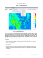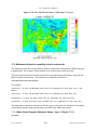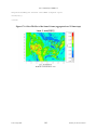
1
User’s Manual for VERDI 1.5
11.4.3.2 Vector Overlays............................................................................................. 79
11.5 GIS Layers ......................................................................................................................81
11.5.1 Add Map Layers .................................................................................................81
11.5.2 Configure GIS Layers .........................................................................................83
12 Supported Grid and Coordinate Systems (Map Projections) ...........................................85
12.1 I/O API-formatted Data ..................................................................................................85
12.2 CAMx Gridded Data .......................................................................................................89
13 I/O API Utilities, Data Conversion Programs, and Libraries ..........................................92
14 Contributing to VERDI Development .................................................................................93
15 Known Bugs............................................................................................................................94
16 Mathematical Functions ........................................................................................................95
16.1 Unary Functions ..............................................................................................................96
16.2 Binary Operators .............................................................................................................96
16.3 Boolean Operators ..........................................................................................................97
16.4 Time Step Index ..............................................................................................................97
17 VERDI Batch Script Editor ..................................................................................................98
17.1 Specify hour/time step formula in batch script mode ...................................................104
17.2 Mathematical function capability in batch script mode ................................................106
17.2.1 Batch Script Example: Maximum Ozone – layer 1 (Figure 17-11) ..................106
17.2.2 Batch Script Example : Minimum Ozone – layer 1 (Figure 17-12) .................107
17.2.3 Batch Script Example : Mean of Ozone – layer 1 (Figure 17-13) ....................108
17.2.4 Batch Script Example : Sum of Ozone – layer 1 (Figure 17-14) ......................109
18 Command Line Scripting ....................................................................................................111
18.1 Example Command Line Script for Linux Users .........................................................111
18.2 Example Command Line Script for Windows Users ....................................................112
19 Areal Interpolation Calculations ........................................................................................117
20 Licenses for JAVA Libraries used by VERDI ..................................................................118
Acknowledgments ......................................................................................................................119
Data Contributions .................................................................................................................119
Data Reader Contributions .....................................................................................................119
I/O Service Provider (IOSP) Interface for CAMx: .......................................................119
Incorporating the IOSP into netcdf-java Library: .........................................................119
UNC–Chapel Hill
v
Institute for the Environment