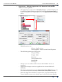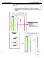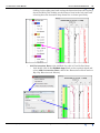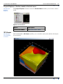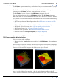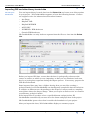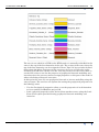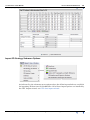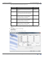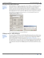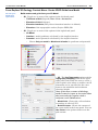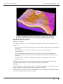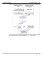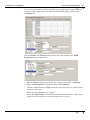
1
GeoModeller User Manual
Contents | Help | Top
3D GeoModeller Reference
1
| Back |
3D GeoModeller Reference
Parent topic:
User Manual
and Tutorials
Contents Help | Top
In this manual:
•
Introduction to 3D GeoModeller, the geological editor
•
Elements of a 3D GeoModeller project
•
User interface overview
•
3D GeoModeller workspace
•
Project Explorer
•
3D Viewer
•
2D Viewer
•
2D Viewer toolbar
•
2D Viewer shortcut menus
•
Points List
•
3D GeoModeller main menus
•
Project menu, Project toolbar and dialog boxes
•
Edit menu and dialog boxes
•
Section menu, toolbar and dialog boxes
•
Geology menu and dialog boxes
•
Model menu, toolbar and dialog boxes
•
Geophysics menu and dialog boxes
•
Mesh and Grid Field Interpolation
•
Import menu and dialog boxes
•
Export menu and dialog boxes
•
View menu and dialog boxes
•
Window menu and dialog boxes
•
Help menu and dialog boxes
•
3D GeoModeller concepts
•
How 3D GeoModeller imports the DTM
•
Model interpolation parameters
•
File formats
•
2D and 3D Meshes and Grids In 3D GeoModeller
•
Introduction to 2D and 3D meshes
•
Mesh Grid Concepts and Types
•
Mesh Grid Operations
•
Mesh and Grid Field Statistical Analysis
•
Mesh and Grid Field Surface Analysis
•
Mesh and Grid Visualisation
© 2013 BRGM & Desmond Fitzgerald & Associates Pty Ltd
| Back |
GeoModeller User Manual
Contents | Help | Top
•
3D GeoModeller Reference
2
| Back |
Mesh and Grid Field Interpolation
•
Inverse Distance Interpolation
•
Variogram Analysis
•
Kriging
•
Domain Kriging
•
Sequential Gaussian Simulation (SGS)
•
3D GeoModeller Operations (‘How to’ instructions)
•
Geoscientific Principles and Underpinnings
•
Copyright and acknowledgments
Toolbar guide
Contents Help | Top
•
Project toolbar: See Project menu, Project toolbar and dialog boxes
•
Section toolbar: See Section menu, toolbar and dialog boxes
•
Structural toolbar: See 2D Structural sub menu and Structural toolbar
•
Points List Editor toolbar: See Points List toolbar (docked)
•
Model toolbar: See Model menu, toolbar and dialog boxes
•
2D Viewer toolbar: See 2D Viewer toolbar
•
3D Viewer toolbar: See 3D Controls sub menu and 3D Viewer toolbar
© 2013 BRGM & Desmond Fitzgerald & Associates Pty Ltd
| Back |
GeoModeller User Manual
Contents | Help | Top
3D GeoModeller Reference
3
| Back |
Introduction to 3D GeoModeller, the geological editor
Parent topic: 3D
GeoModeller
Reference
Three dimensional modelling of the geology formations of the earth is an essential
step towards effective understanding of complex geological phenomena.
In order to be relevant, such 3D modelling must be based not only on the whole of
knowledge and the data available for the study area (maps, sections, terrain models,
drillholes, etc.) but also on geological interpretation.
3D GeoModeller was designed to assemble together into the same 3D space data
from various sources, in order to ensure geometrical coherence. To make this easier,
3D GeoModeller enables the geologist to work with familiar geological tools such as
maps, sections and drillholes. Moreover, it provides the geologist-interpreter with the
tools needed to impose their geological interpretation.
One of the innovations of 3D GeoModeller is the construction of geology
interpolation which take into account not only the geology 'boundary' data (geology
contacts, or interfaces or limits), but also incorporates the dip of the geology
formations.
After computing the model, 3D GeoModeller can present it on a (geology) map, in
cross-sections or as 3D shapes (volumes) defined by triangulated surfaces.
The development of a geometrical model is an essential first step for a wide range of
later calculations. For example, a constrained and coherent model is essential for
calculating volumes, conducting hydro-geologic simulations, calculating geophysical
(gravimetric and magnetic) signatures, and for many other applications.
With 3D GeoModeller you can build a coherent 3D model which respects your data.
Furthermore, its data-interchange abilities enable you to exchange data and results
with other applications.
For more information about the architecture of 3D GeoModeller projects, see the
Elements of a 3D GeoModeller project.
For more information about the 3D GeoModeller user interface, see User interface
overview. To assist you in your use of the software, note that most of 3D
GeoModeller's dialog boxes include a help button.
To get started with 3D GeoModeller, see 3D GeoModeller Tutorials and Help—
Introduction. The tutorials use simple but practical examples, which lead you
through the essential stages in the development of a 3D model.
Contents Help | Top
© 2013 BRGM & Desmond Fitzgerald & Associates Pty Ltd
| Back |
GeoModeller User Manual
Contents | Help | Top
3D GeoModeller Reference
4
| Back |
Elements of a 3D GeoModeller project
Parent topic: 3D
GeoModeller
Reference
In this section:
•
The project
•
The topographic surface
•
Geology objects—formations, faults, axial series and surfaces
•
The stratigraphic pile
•
Sections
•
Drillholes
•
Structural data
•
•
Geology data
•
Geology orientation data (dip and dip direction)
•
Axial surface orientation data
•
Axial surface data (axial traces)
•
Hinge lines
The 3D model
The project
Parent topic:
Elements of a
3D
GeoModeller
project
The project is a set of data representing 3D space. It contains a structure, which
gathers together the elements of your study.
Project properties
The project properties include descriptive data, location, limits and parameters. For
a detailed description see Project Properties dialog box.
Project data that you import or create:
•
Topographic surface
•
Sections
•
Formations, series and the stratigraphic pile
•
Axial series (families), surfaces
•
Geology contact and orientation data points
•
Drillholes
3D GeoModeller shows all project components in the tree-structured Project
Explorer list.
Project storage
3D GeoModeller stores projects in XML format.
3D GeoModeller stores all components in a folder. The main file of the project has
the same name as the folder and a .xml extension.
Project operations
All project operations appear in the File menu and the commonly used ones in the
Project toolbar. See:
Contents Help | Top
•
Project menu, Project toolbar and dialog boxes (user interface reference)
•
Project and file operations (‘How to ...’ instructions)
© 2013 BRGM & Desmond Fitzgerald & Associates Pty Ltd
| Back |
GeoModeller User Manual
Contents | Help | Top
3D GeoModeller Reference
5
| Back |
The topographic surface
Parent topic:
Elements of a
3D
GeoModeller
project
In 3D GeoModeller there are two ways to generate a 3D topographic surface for the
project:
•
From a digital terrain model (DTM) in a variety of available grid formats (See
Load Topography from a DTM dialog box)
•
By using a horizontal plane, located at a specified height in the project model
space (See Define Topography as an Horizontal Plane dialog box)
For the properties of the topographic surface, see Topography Properties dialog box.
To perform topographic surface operations use the Project Explorer or options in the
Section menu. See:
•
Section menu, toolbar and dialog boxes (user interface reference)
•
Project Explorer—Sections shortcut menus (user interface reference)
•
Topography and section operations (‘How to ...’ instructions)
Geology objects—formations, faults, axial series and surfaces
Parent topic:
Elements of a
3D
GeoModeller
project
3D GeoModeller models contain three types of geology object:
•
Geology formation (which belongs to a geology series, which in turn belongs to the
stratigraphic pile)
•
Fault
•
Axial surface (which belongs to an axial series (family)
When you create a geology object in 3D GeoModeller, you specify:
•
Properties that 3D GeoModeller uses, including name and colour
•
(Formations) The series to which it belongs (You can create series and associate
formations after you create them)
•
(Axial surfaces) The axial series to which it belongs (You need to create the axial
series before the axial surface)
•
Other information for your own use that 3D GeoModeller doesn’t use
Before 3D GeoModeller can work with a formation, fault or axial surface, you need
to associate geology data with it. For an axial surface you also need to create a
section from it.
To perform formation and fault operations use the Project Explorer or options in the
Geology menu. See:
•
Geology menu and dialog boxes (user interface reference)
•
Project Explorer—Formations shortcut menus (user interface reference)
•
Geology formations and series operations (‘How to ...’ instructions)
To perform axial series and surface operations use the Project Explorer or options in
the Geology menu. See:
Contents Help | Top
•
Geology menu and dialog boxes (user interface reference)
•
Project Explorer—Sections shortcut menus (user interface reference)
•
Structural data operations (‘How to ...’ instructions)
© 2013 BRGM & Desmond Fitzgerald & Associates Pty Ltd
| Back |
GeoModeller User Manual
Contents | Help | Top
3D GeoModeller Reference
6
| Back |
The stratigraphic pile
Parent topic:
Elements of a
3D
GeoModeller
project
The stratigraphic pile defines the sequential order of geology formations or events.
This ‘order of events’ makes it possible to manage the relations between the geology
formations in the computation (and interrogation) of 3D model. In a sedimentary
terrain, it defines the chronology of the stratigraphic sequence.
The stratigraphic pile is sub-divided into series. Each series comprises one or more
geology formations. 3D GeoModeller interpolates geology formations of any given
series so that they remain generally parallel.
You can define the relationship of each series with ‘older’ series as ‘on-lapping’ or
‘erosional’ (cross-cutting). This is an important ‘switch’, which controls the nature of
the contact between the formations when interrogating the model and generating
model outputs such as model geology on maps and in sections.
The Reference (Top or Bottom) of the pile tells 3D GeoModeller whether the
structural data contained in the map, sections and drillholes represent the top
contacts or the basal contacts of the formations with which they are associated.
To perform series and stratigraphic pile operations use the Project Explorer or
options in the Geology menu. See:
•
Geology menu and dialog boxes (user interface reference)
•
Project Explorer—Formations shortcut menus (user interface reference)
•
Geology formations and series operations (‘How to ...’ instructions)
Sections
Parent topic:
Elements of a
3D
GeoModeller
project
3D GeoModeller uses sections to define geology. It considers the topographic surface,
which contains the geological map, a special instance of a section.
When you are building a 3D model of geological formations, you typically create
sections and define or interpret the geology within those section views.
It is easy to create sections in 3D GeoModeller. You can:
•
Use points you have clicked and recorded in the Points List (Creating a section
from its trace)
•
Define horizontal sections at a specified depth.
To perform section operations use the Project Explorer or options in the Section
menu or toolbar. See:
Contents Help | Top
•
Section menu, toolbar and dialog boxes (user interface reference)
•
Project Explorer—Sections shortcut menus (user interface reference)
•
Topography and section operations (‘How to ...’ instructions)
© 2013 BRGM & Desmond Fitzgerald & Associates Pty Ltd
| Back |
GeoModeller User Manual
Contents | Help | Top
3D GeoModeller Reference
7
| Back |
Drillholes
Parent topic:
Elements of a
3D
GeoModeller
project
Drillhole functions in 3D GeoModeller are summarised below.
Drillhole operations are available in the Import menu, the Project Explorer tree
(Formations and Drillholes) and from the Model menu or toolbar (Project Data
onto Sections in the 2D Viewer). See:
•
Importing drillholes and drillhole geophysical logs and assays
•
Project Explorer and 2D Viewer—Drillholes shortcut menus (user interface
reference)
•
Model menu, toolbar and dialog boxes (user interface reference—visualising)
•
•
Model operations (‘How to ...’ instructions—visualising)
Project Explorer—Formations shortcut menus (user interface reference—
drillholes associated with formations)
Structural data
Parent topic:
Elements of a
3D
GeoModeller
project
3D GeoModeller uses five distinct types of geology (structural) data. You can view
these in the 2D Viewer.
Structural data type
Associated with
Geology data contact points
Formation or fault
Geology orientation data (dip and dip direction)
Formation or fault
Axial surface data (axial traces)
Axial surface (describing folds)
Axial surface orientation data
Axial series (describing folds)
Hinge line data
Formation (describing folds)
3D GeoModeller uses all of these elements when it computes the 3D model.
3D GeoModeller regards faults, formations, axial surfaces and series as objects in
the model which may have structural data attached to them. For more information
about these, see Geology objects—formations, faults, axial series and surfaces.
You can input these data interactively in the 2D Viewer or import them into your
project.
3D GeoModeller displays each data point in the colour of the geology formation,
fault or axial surface with which it is associated.
Contents Help | Top
© 2013 BRGM & Desmond Fitzgerald & Associates Pty Ltd
| Back |
GeoModeller User Manual
Contents | Help | Top
3D GeoModeller Reference
8
| Back |
To perform structural data operations use options in the Import menu (importing)
and Structural menu or toolbar (creating and editing). See:
•
Import menu and dialog boxes (user interface reference—importing)
•
Points List (user interface reference—creating in 2D Viewer)
•
Geology menu and dialog boxes (user interface reference—creating and editing)
•
Structural data operations (‘How to ...’ instructions—importing)
•
Structural data operations (‘How to ...’ instructions—creating and editing)
In this section—types of object
•
Geology data
•
Geology orientation data (dip and dip direction)
•
Axial surface data (axial traces)
•
Axial surface orientation data
•
Hinge lines
Geology data
A geology data point represents a point on a geology ‘surface’ such as an interface
(contact) or fault. It has the following parameters:
•
The (u, v) coordinates of the point (For an explanation of (u, v) see Status bar and
conventions for spatial coordinates)
•
The name of the geology formation on whose surface the points lies
The properties of the stratigraphic pile determine whether the points are on the
top of the formation or the bottom. See Create or Edit Geology Series and the
Stratigraphic Pile dialog box
•
(Optionally) associated geology orientation data
For more information about properties see Create (or Edit) Geology Data dialog box.
Geology orientation data (dip and dip direction)
A geology orientation data point represents the dip and dip direction of a geology
surface at that point. It has the following parameters:
•
The dip direction and the dip (using Hoek’s convention—the line of maximum
slope)
•
The (u, v) coordinates of the point (For an explanation of (u, v) see Status bar and
conventions for spatial coordinates)
•
The polarity (normal or reverse) (See Overturned geology)
•
The geology formation with which this data point is associated
For more information about properties see Create (or Edit) Geology Orientation Data
dialog box.
You need to input geology orientation data one point at a time.
For more information about properties see Create (or Edit) Geology Orientation Data
dialog box.
Contents Help | Top
© 2013 BRGM & Desmond Fitzgerald & Associates Pty Ltd
| Back |
GeoModeller User Manual
Contents | Help | Top
3D GeoModeller Reference
9
| Back |
Axial surface data (axial traces)
An axial surface data point (or point on an axial trace) defines the surface of
symmetry of a fold. It has the following parameters:
•
The (u, v) coordinates of the point (For an explanation of (u, v) see Status bar and
conventions for spatial coordinates)
•
The name of the axial surface
For more information about properties and conversion to a section, see:
•
Create (or Edit) Axial Surface Data (an Axial Trace on a Map) dialog box.
•
Create a Section from an Axial Surface dialog box
Axial surface orientation data
An axial surface orientation data point is the dip and dip direction of an axial surface
(locally, an axial plane), and is used to represent the direction (or elongation) of a fold
structure in a 3D GeoModeller project. It has the following parameters:
•
The dip and dip direction (using Hoek’s convention—the line of maximum slope)
•
The (u, v) coordinates of the point (For an explanation of (u, v) see Status bar and
conventions for spatial coordinates)
•
The polarity (See Overturned geology)
•
The plunge
•
The associated axial series
Note that axial surface orientation data is associated with an axial series, not a
single axial surface, since it indicates the orientation of the fold structure
You need to input axial surface orientation data one point at a time.
For more information about properties see Create (or Edit) Axial Surface Orientation
Data dialog box.
Hinge lines
A hinge line is a line intersecting an axial surface and a geology horizon (geology
contact or interface). It represents the trace of the points of maximum curvature of a
layer affected by a fold.
Create hinge lines within sections created from axial surface.
Hinge lines have the following parameters:
•
A set of points, each having (u, v) coordinates (For an explanation of (u, v) see
Status bar and conventions for spatial coordinates)
•
The geology formation intersecting the axial surface section
•
Parameters specifying the aperture and distance
•
Polarity (left or right)
For more information about properties see Create (or Edit) Hinge Line Data dialog
box.
Contents Help | Top
© 2013 BRGM & Desmond Fitzgerald & Associates Pty Ltd
| Back |
GeoModeller User Manual
Contents | Help | Top
3D GeoModeller Reference
10
| Back |
The 3D model
Parent topic:
Elements of a
3D
GeoModeller
project
3D GeoModeller uses the geology and structural data recorded on the map
(topography), in sections and in drillholes to compute a 3D model of the geology. It
also must use the information recorded in the stratigraphic pile for the project.
The model is a set of mathematical equations, but it is possible to present the model
in a variety of ways. For example, as 3D shapes or volumes, or plotted as model
geology in the 2D map view or section views of the project.
3D model operations
•
•
In a 2D Viewer
•
Plot the 2D model geology, being the intersection of the (3D mathematical)
model with the (2D) map or section, in outline form or filled
•
Plot the model along the section markers (of intersecting sections) in the 2D
viewer
•
Display or hide the plot of model geology
•
Delete the plot of model geology
In the 3D Viewer
•
From the 3D (mathematical) model, build 3D shapes for each geology
formation
•
Display or hide the 3D representation of the model geology for any formation
•
Present a formation of the model geology as either shaded or in wireframe
•
Change the appearance of the 3D representation of a formation of the model
geology
To perform 3D model operations use the Project Explorer or options in the Model
menu or toolbar. See:
Contents Help | Top
•
Model menu, toolbar and dialog boxes (user interface reference)
•
3D Viewer (user interface reference)
•
Project Explorer—Models shortcut menus (user interface reference)
•
Model operations (‘How to ...’ instructions)
© 2013 BRGM & Desmond Fitzgerald & Associates Pty Ltd
| Back |
GeoModeller User Manual
Contents | Help | Top
3D GeoModeller Reference
11
| Back |
User interface overview
Parent topic: 3D
GeoModeller
Reference
3D GeoModeller’s user interface has the following elements. There are normally
several ways of performing an operation. You may be able to perform the same
operation using the main menu or a shortcut menu or a toolbar.
•
3D GeoModeller workspace. A main window, which contains the main menu and
the toolbars.
•
3D GeoModeller main menus
•
Toolbars:
•
Project menu, Project toolbar and dialog boxes
•
Section menu, toolbar and dialog boxes
•
2D Structural sub menu and Structural toolbar
•
Points List toolbar (docked)
•
Model menu, toolbar and dialog boxes
•
2D Viewer toolbar
•
3D Controls sub menu and 3D Viewer toolbar
•
The Project Explorer which presents in a tree structure all of the data objects
managed within the project. Each node of the tree has a shortcut menu for
common operations on the object it represents.
•
The 2D Viewer for the display of the map and sections, and for presentation of 2D
model objects. The 2D Viewer has a shortcut menu for common operations. See
2D Viewer sub menu and main shortcut menu, Project Explorer Section menus.
•
The 3D Viewer for the display and presentation of 3D model objects. The 3D
Viewer has a shortcut menu for common operations. See 3D Viewer sub and
shortcut menu.
•
The Points List enables you to enter data or specify parameters by clicking points
in the 2D Viewer.
3D GeoModeller workspace
Parent topic:
User interface
overview
Contents Help | Top
In this section:
•
3D GeoModeller workspace—Introduction
•
Status bar and conventions for spatial coordinates
© 2013 BRGM & Desmond Fitzgerald & Associates Pty Ltd
| Back |
GeoModeller User Manual
Contents | Help | Top
3D GeoModeller Reference
12
| Back |
3D GeoModeller workspace—Introduction
Parent topic: 3D
GeoModeller
workspace
When you launch 3D GeoModeller, main window appears with the main menu and
toolbars.
When a project opens, the interface expands to present a workspace, the upper part of
which has the main menu and toolbars, and a lower part containing a number of
dockable windows.
Contents Help | Top
© 2013 BRGM & Desmond Fitzgerald & Associates Pty Ltd
| Back |
GeoModeller User Manual
Contents | Help | Top
3D GeoModeller Reference
13
| Back |
Status bar and conventions for spatial coordinates
Parent topic: 3D
GeoModeller
workspace
In the Status Bar, the Points List Editor and the Tape Measure, 3D GeoModeller
uses the following notation to describe spatial coordinates.
As you point to a position in the 2D Viewer, 3D GeoModeller displays the
coordinates of the point in the Status Bar.
See also:
•
Points List Editor (floated)
•
Tape Measure
Y indicates that the term is present in the 3D GeoModeller feature.
Notation
Purpose
n or #
Number of point in sequence
x, y, z
x, y, z coordinates of point
u, v
Local coordinates in the current plane
xyz, uv,
Length,
Distance
Distance to previous point
Status
bar
Points
list
Tape
measure
Y
Y
Y
Y
Y
Y
Y
Y
Y
Y
In Tape Measure, if you are measuring
the Topography section, you need to
take care when measuring steep
terrain:
•
xyz takes vertical distance into
account
•
uv takes only horizontal (xy)
distance into account
Bearing
(Tape measure) Angle with respect to
the v direction in degrees, clockwise
positive
Angle
(Points list editor) Angle with respect
to the v direction in degrees, clockwise
positive
Y
Y
Y
(Tape measure) Absolute angle with
respect to the previous line segment in
the list, where 180° is the direction of a
continuation of the line of the two
previous points and 0° is the direction
of the line from the previous point to
the one before, in degrees, in the range
0..180
Contents Help | Top
© 2013 BRGM & Desmond Fitzgerald & Associates Pty Ltd
| Back |
GeoModeller User Manual
Contents | Help | Top
3D GeoModeller Reference
14
| Back |
Project Explorer
Parent topic:
User interface
overview
In this section:
•
Project Explorer—Introduction
•
Common shortcut menu options
•
Project Explorer—Project Explorer window and Project shortcut menus
•
Project Explorer—Formations shortcut menus
•
Project Explorer and 2D Viewer—Faults shortcut menus
•
Project Explorer—Models shortcut menus
•
Project Explorer—Sections shortcut menus
•
Project Explorer and 2D Viewer—Drillholes shortcut menus
•
Project Explorer and 2D Viewer—Drillhole Visualisation
•
Project Explorer and 2D Viewer—Drillhole Edit
•
Project Explorer—Surface meshes shortcut menu
Project Explorer—Introduction
Parent topic:
Project
Explorer
The Project Explorer is a special master window, which presents all of the data
objects of a project in an tree structure. It provides you with an overview of the entire
project data.
It has a tree structure containing all of the data objects of the project. It provides a
global view of the entire project with all of its components. You can use it to perform
certain actions without needing to use the 2D Viewer to select an object.
Shortcut menus are available for every node of the Project Explorer tree, offering
appropriate options for the associated object, object type or object group. Shortcut
menus are generally the same for any context Project Explorer and in the 2D Viewer
and 3D Viewer.
Contents Help | Top
© 2013 BRGM & Desmond Fitzgerald & Associates Pty Ltd
| Back |
GeoModeller User Manual
Contents | Help | Top
3D GeoModeller Reference
15
| Back |
Common shortcut menu options
Parent topic:
Project
Explorer
In the Project Explorer you can select shortcut menu options for all objects or types of
objects in the project. Some menu options are common to several object types and
enable similar operations. The following table contains an overview of the common
shortcut menu options
Option
Description
Properties,
Attributes
Display the properties dialog box for the
object. Selecting Properties for
Drillholes opens the drillhole log visual.
Show, Hide
Display or hide the object or group of
objects in the viewers
Wireframe
Display:
Shading
Appearance
•
Wireframe for a 3D model volume or
a group of volumes
•
Outlines for other data
Icon
Display:
•
Formation shading in a 3D model
volume or group of volumes
•
Background colour for a section or
group of sections.
Display the Appearance of an object
dialog box for the object or the group of
objects.
Appearance for Drillholes allows the
drillhole display diameter to be changed
If you set appearance for a group of
objects, 3D GeoModeller applies the
settings to future new objects in the
group.
See Appearance of objects dialog box
family.
Delete
Contents Help | Top
Delete the object or group of objects
© 2013 BRGM & Desmond Fitzgerald & Associates Pty Ltd
| Back |
GeoModeller User Manual
Contents | Help | Top
3D GeoModeller Reference
16
| Back |
Project Explorer—Project Explorer window and Project shortcut menus
Parent topic:
Project
Explorer
Use Project Explorer window shortcut menu option Refresh to refresh the Project
Explorer
Use the Project object shortcut menu to save the project, show the project in its folder,
or display properties.
Options in these menus.
Option
Description
Save, Save As
See Save a project (and Save As ...).
Properties
See Project Properties dialog box.
Project Explorer—Formations shortcut menus
Parent topic:
Project
Explorer
The Project Explorer shortcut menus for Formations generally, individual series and
individual formations enable you to work on those objects at different levels of
grouping.
Options in these menus.
Contents Help | Top
Option
Description
Create a formation
See Create or Edit Geology Formations dialog box
Appearance
Edit the appearance of the object or group of objects. See
Appearance of objects dialog box family.
Attributes
See Edit Geological Formation Attributes dialog box
Delete
Delete the object or group of objects or data
© 2013 BRGM & Desmond Fitzgerald & Associates Pty Ltd
| Back |
GeoModeller User Manual
Contents | Help | Top
3D GeoModeller Reference
17
| Back |
Project Explorer and 2D Viewer—Faults shortcut menus
Parent topic:
Project
Explorer
The Project Explorer shortcut menus for Faults generally and for individual faults
enable you to work on those objects together or individually.
The Fault shortcut menu in the 2D Viewer enables you to work on individual faults.
These menus are similar, so we describe them in the same section.
Options in these menus.
Option
Description
Create a fault
See Create or Edit Faults dialog box.
Appearance
Edit the appearance of the object or type of object. See
Appearance of objects dialog box family
Attributes
See Fault Properties (attributes) dialog box.
Edit
See Create or Edit Faults dialog box
Delete
Delete the fault
Project Explorer—Models shortcut menus
Parent topic:
Project
Explorer
The Project Explorer shortcut menus for the current 3D Model and its components
enable you to work on those objects in groups or separately.
Options in these menus.
Contents Help | Top
Option
Description
Show, Hide, Shading, Wireframe,
Appearance
See Common shortcut menu options.
© 2013 BRGM & Desmond Fitzgerald & Associates Pty Ltd
| Back |
GeoModeller User Manual
Contents | Help | Top
3D GeoModeller Reference
18
| Back |
Project Explorer—Sections shortcut menus
Parent topic:
Project
Explorer
The Project Explorer shortcut menus for Sections generally, individual sections or
topography and images attached to a section enable you to work on those objects at
different levels of grouping or individually.
This section describes the Sections shortcut menu (for all sections together) and the
shortcut menu for images attached to sections. For information about the shortcut
menu of topography, individual sections and axial surfaces, see 2D Viewer sub menu
and main shortcut menu, Project Explorer Section menus
Sections shortcut menu
Section > image
shortcut menu
Section shortcut menu
(described elsewhere—see
2D Viewer sub menu and
main shortcut menu,
Project Explorer Section
menus)
Contents Help | Top
© 2013 BRGM & Desmond Fitzgerald & Associates Pty Ltd
| Back |
GeoModeller User Manual
Contents | Help | Top
3D GeoModeller Reference
19
| Back |
Options in these menus
Option
Description
Show, Hide,
Shading,
Wireframe,
Appearance
See Common shortcut menu options.
For images:
•
Rotate through the images attached to the section using
the PAGEUP and PAGEDOWN keys.
•
Hide the image using the END key.
Open, Close all
2D Viewers
(Open) Open a 2D Viewer window for all sections.
Vertical
Exaggeration
See Vertical exaggeration submenu and toolbar.
Reset all
viewers
Adjust pan and zoom of each 2D Viewer window so that the
display is all visible and fills the window.
Show (or hide)
all modelled
geology lines
(or polygons) in
3D Viewer
(Show) For each section where model data is visible (lines or
polygons or both), display the same data in the 3D Viewer.
Erase all model
geology
Erase model display from all sections in the 2D Viewer and 3D
Viewer
Regenerate all
section
intersections
Choose this option to force 3D GeoModeller to regenerate
section intersections. If you change the model precision or
topography, you need to update the relationships between
sections.
Edit
(Images only) See Edit and Align Image dialog box
Delete
(Sections) Delete all sections from the project
(Close) Close all 2D Viewers
(Hide) Hide all model data displayed on sections in the 3D
Viewer
(Images) Delete the image from the project
Contents Help | Top
© 2013 BRGM & Desmond Fitzgerald & Associates Pty Ltd
| Back |
GeoModeller User Manual
Contents | Help | Top
3D GeoModeller Reference
20
| Back |
Project Explorer and 2D Viewer—Drillholes shortcut menus
Parent topic:
Project
Explorer
The Project Explorer context menus for Drillholes enable you to work on those objects
together or individually.
The Drillhole context menu in the 2D Viewer enables you to work on individual
drillholes.
These menus are similar, so we describe them in the same section.
•
The following functions are available from the main Explore > Drillholes context
menu
Functions in the Drillholes context menu.
Function
Description
Show, Hide
See Common shortcut menu options.
Shading, Wireframe
See Common shortcut menu options
Appearance
Accessible in Shading Mode only; change the
Drillhole radius in the 3D Viewer.
See Appearance of Drillholes dialog box
Contents Help | Top
Import
See Importing drillholes and drillhole geophysical
logs and assays
Fields to Regular Intervals
Recalculate Fields to a regular From/To interval
Fields to Data Points Mesh
From Explore Context Menu: Drillhole fields to data
points mesh
Delete
Delete all drillholes from the project
© 2013 BRGM & Desmond Fitzgerald & Associates Pty Ltd
| Back |
GeoModeller User Manual
Contents | Help | Top
•
3D GeoModeller Reference
21
| Back |
The following functions are available from the main Explore > Drillholes >
DrillholeName context menu ie RightClick on an individual drillhole in the list
Options in the individual Drillhole context menu.
Option
Description
Show, Hide
See Common shortcut menu options.
Shading, Wireframe
See Common shortcut menu options
Appearance
Accessible in Shading Mode only; change the
Drillhole radius in the 3D Viewer.
See Appearance of Drillholes dialog box
Contents Help | Top
Edit
Edit an individual drillhole
Delete
Delete all drillholes from the project
Properties
Display the selected drillhole in the Drillhole Viewer
© 2013 BRGM & Desmond Fitzgerald & Associates Pty Ltd
| Back |
GeoModeller User Manual
Contents | Help | Top
•
3D GeoModeller Reference
22
| Back |
The following functions are available from the context menu of a selected Drillhole
in the 2D Viewer ie RightClick on a selected drillhole.
Options in these menus.
Option
Description
Show, Hide
Show/Hide the selected drillhole in the 3D Viewer
See Common shortcut menu options
Appearance
Inactive in the 2D Viewer
Edit
Edit an individual drillhole
Properties
Display the selected drillhole in the Drillhole Viewer
Delete
Delete the selected drillhole from the project
The Drillhole Fields to Regular Intervals, Drillhole Properties and Drillhole Editing
functions are discussed in detail below.
Project Explorer and 2D Viewer—Drillhole Visualisation
Parent topic:
Project
Explorer
Drillhole Properties
•
Display the selected drillhole in the Drillhole Viewer
Selecting Properties from any of the Explore Drillhole context menus opens the
drillhole log in a graphic viewer. The viewer displays the drillhole as a section down
the hole path with the following features:
Contents Help | Top
•
Depth labels at regular depth intervals down the hole path.
•
Logged Geology in the current Model Pile colours.
•
Computed Model Geology in the current Model Pile colours.
© 2013 BRGM & Desmond Fitzgerald & Associates Pty Ltd
| Back |
GeoModeller User Manual
Contents | Help | Top
3D GeoModeller Reference
23
| Back |
•
From/To profiles of numeric Fields (autoscaled) on the same depth axis as the
Geology
•
Log title with Holename, X,Y Collar coordinate and a Misfit estimate of the
Logged versus Modelled geology.
The Drillhole Properties Viewer has a set of dropdown menus which provide the
following functionality. The Help menu is inactive.
Contents Help | Top
© 2013 BRGM & Desmond Fitzgerald & Associates Pty Ltd
| Back |
GeoModeller User Manual
Contents | Help | Top
3D GeoModeller Reference
24
| Back |
Options in the Drillhole Properties menus.
Option
Description
Drillholes >
Load
Open a Drillhole log for the selected drillhole - Drillholes > Load
> Select a Drillhole
Drillholes >
Load closed...
Select Drillhole within specified distance of the current drillhole
- Drillholes > Load Closed... > Select a Drillhole within Range
Drillholes >
Save
Inactive in this Mode. See Drillhole Edit. Save an interactive
Edit operation.
Drillholes >
Save as
Save the current Drillhole log to a PNG file
Drillholes >
Print
Print the current drillhole log view to the selected Printer
Drillholes > Exit
Exit from the current drillhole properties viewer
Edit > Undo
Inactive in this Mode. See Drillhole Edit. Undo an interactive
Edit.
Edit > Delete
Delete the current drillhole from this Project
Format > Fields:
Single View
Display all numeric Field profiles overlayed in one panel
Format > Fields:
Multiple Views
Display all numeric Field profiles in individual panels (Default)
Format >
Generalize
Fields Colour
Not active in this release.
Help >
Help Menu inactive in this release.
•
Drillholes > Load > Select a Drillhole
•
Contents Help | Top
Select and Click OK to open another Drillhole log
© 2013 BRGM & Desmond Fitzgerald & Associates Pty Ltd
| Back |
GeoModeller User Manual
Contents | Help | Top
•
•
Contents Help | Top
3D GeoModeller Reference
25
| Back |
Drillholes > Load Closed... > Select a Drillhole within Range
•
Choose a maximum distance within which to find a neighbouring hole.
•
Select a drillhole from the list and click OK to view the Drillhole log
Drillholes > Save As
•
Save the current Drillhole log to a PNG file
•
The standard file Save dialog opens; select a path and enter a name for the
PNG file.
© 2013 BRGM & Desmond Fitzgerald & Associates Pty Ltd
| Back |
GeoModeller User Manual
Contents | Help | Top
3D GeoModeller Reference
26
| Back |
Project Explorer and 2D Viewer—Drillhole Edit
Parent topic:
Project
Explorer
•
•
•
Contents Help | Top
Edit an individual drillhole
Left mouse select an individual drillhole from the tree and choose Edit
The Drillhole Properties dialog opens with the Editing options activated and
with the additional interactive Explore/Edit Drillhole Log pane on the left
© 2013 BRGM & Desmond Fitzgerald & Associates Pty Ltd
| Back |
GeoModeller User Manual
Contents | Help | Top
•
3D GeoModeller Reference
27
| Back |
The Top level Menus Drillholes and Edit described as inactive under Drillhole
Properties now support the following extra options.
Drillholes >
Save
Save Editing operations completed on the current drillhole
Edit > Undo
Undo Editing operations completed on the current drillhole
•
Explore Edit Drillhole log (Left Side Panel tree) - Drillhole interactive editing
in the left side panel of the Drillhole Properties dialog supports the following
operations
•
Edit a Drillhole Collar location by clicking on Collar location and editing
the coords in the popup dialog or by clicking on X or Y or Z individually.
•
Edit a Lithology From/To.
•
Edit the Lithology of a From/To using the drop down Formation list.
•
Define a Lithology interval as Relaxed or Not Relaxed (Default).
•
Delete a Numeric field ie Fe assay etc.
•
Edit the Appearance of a Numeric field (Profile colour, Vertex Symbol).
•
Hide/Display a Numeric profile.
•
Calculate and Display the histogram of a Drillhole numeric field.
•
Save/Undo any Edits or Visual changes to a Drillhole.
•
The Fields (assays),... right click context menu has the following options
•
Multi Cross Plot Analysis (Also available under Meshes and Grids once
the drill numeric fields are converted to a Vertex Mesh)
•
Show All Numeric Fields
•
Generalise these Graphic Aspects
•
Delete All Numeric Fields
•
Create Fields on Constant Support (Also available from the context
menu accessible from the Drillholes item in the main Explore tree)
None of these options are saved until the user selects the Drillholes>Save option in
the Top level menu as described above. Any of these operations can be undone by
selecting Undo in the top level Edit menu.
Contents Help | Top
© 2013 BRGM & Desmond Fitzgerald & Associates Pty Ltd
| Back |
GeoModeller User Manual
Contents | Help | Top
3D GeoModeller Reference
28
| Back |
•
•
Edit a Lithology From/To
•
Edit the To: depth for ORE2 from 207.9 to 205.1 and press the ENTER
key to update the ORE2 To: depth to 205.1.
•
This change will force an update of the WAST From: depth to 205.1 to
match the updated To:. No gap will be created.
Editing the Lithology of an existing From/To Interval
• Left Click on the Interval Formation Icon and
select a Formation from the dropdown list
•
Contents Help | Top
Define a Lithology interval as Relaxed or Not Relaxed (Default)
•
Click on the Not relaxed item at the foot of a Lithology interval and it
will change to Relaxed as shown in the example for TOP below. This
option is not available for the last interval in a drillhole since the end
point is not a real contact ie the hole stops within this unit. This depth
point is always relaxed but is available for use with the Compute
Inequality option discussed in the Note below.
•
If a lithology interval is relaxed, the contact point at this interface will
not be used to compute the model.
•
When the Lithology interval is relaxed a new column appears beside
the modelled geology column in the right hand panel. This is the User
Defined Data column and the horizontal black bar indicates that the
contact between TOP and ORE2 is relaxed as shown in the example
figure below.
•
A Relaxed Interface is also added to the User Defined Data section of
the Explore/Edit Drillhole Log panel (see below).
© 2013 BRGM & Desmond Fitzgerald & Associates Pty Ltd
| Back |
GeoModeller User Manual
Contents | Help | Top
3D GeoModeller Reference
29
| Back |
Note: Drillhole lithology contact points are added to the geological model data as 3D
contact points if the drillhole is selected in the Model->Compute dialog. Any
orientation data added to the drillhole is also used in the Compute. The last lithology
interval To: point at the drillhole bottom is also added as a lithology constraint point
but is only active if the Inequality toggle is selected in the Model->Compute panel.
•
Delete a Numeric field ie Fe assay etc
•
Contents Help | Top
Right click on a numeric field in the list at the base of the Explore/
Edit Drillhole Log panel and select Delete this Field
© 2013 BRGM & Desmond Fitzgerald & Associates Pty Ltd
| Back |
GeoModeller User Manual
Contents | Help | Top
3D GeoModeller Reference
30
| Back |
•
Appearance - Edit the Appearance of a Numeric field (Profile
colour, Vertex Symbol)
•
The Appearance of the numeric Fields (assays,...) column display can
be edited by Right Clicking on the Field and selecting Appearance
then choosing from the display options in the Appearance of an Object
dialog
•
Editable options are:
Colour - Profile colour.
Vertex Symbol - Drawn at the From/To points.
•
The following options are NOT active:
Polygon Filling
Display Mode
Material
Vertex Symbol Size
Line Width
Line Type
Contents Help | Top
•
Changes are not visible until saved and the Drillhole Viewer is
reopened.
•
Appearance changes saved are applied to the chosen field in all
Drillholes.
•
The Vertex Symbol shown in the Appearance of an Object dialog does
not reflect the symbol currently in use for the Field profile column.
•
When the Appearance Editor is reopened for a chosen field then the
Vertex Symbol reverts to its default type in the Field column display.
© 2013 BRGM & Desmond Fitzgerald & Associates Pty Ltd
| Back |
GeoModeller User Manual
Contents | Help | Top
3D GeoModeller Reference
31
| Back |
•
Hide/Display a Numeric profile
•
•
Histogram - Calculate and Display the histogram of a Drillhole
numeric field
•
Contents Help | Top
Right Click on Assay field and select Hide/Display
Right Click on Field and select Histogram, The histogram and
summary statistics for the selected field in the current drillhole are
displayed.
© 2013 BRGM & Desmond Fitzgerald & Associates Pty Ltd
| Back |
GeoModeller User Manual
Contents | Help | Top
•
3D GeoModeller Reference
32
| Back |
Drillhole logs (Right Side Panel columns) - Drillhole interactive editing in the
right side panels of Drillhole Properties of the Drillhole Properties dialog by
left/right mouse clicks and context menu selection supports the following
operations
•
•
Right Click Menu options:
•
Properties: Edit the Properties of the Drillhole logs column display;
the most siginificant of these is to change the vertical drillhole column
layout to horizontal and to manipulate the axes scales and zoom.
•
Copy: Copy the Drillhole log view to the Clipboard
•
Save as..: Save the Drillhole log to a PNG
•
Print: Print the Drillhole log to a Windows printer
•
Zoom In
•
Zoom Out
•
Auto Range
Menu options available when double click in the Geology, Model, User
Defined or Assay Field columns.
•
Choose a Formation for the current interval from the drop down list
(top menu item).
•
Remove Interval: Remove a Lithology interval from the drillhole log
•
Split Interval: Split an existing Lithology interval; also used to Add
an interval.
•
Add Orientation Data to the drillhole log
•
Relax/Unrelax this Interface: Relax or unrelax the current interface
None of these options are saved until the user selects the Drillholes>Save option in
the Top level menu as described above. Any of these operations can be undone by
selecting Undo in the top level Edit menu.
•
Contents Help | Top
Properties - Right Click in Drillhole logs panel and select Properties
© 2013 BRGM & Desmond Fitzgerald & Associates Pty Ltd
| Back |
GeoModeller User Manual
Contents | Help | Top
3D GeoModeller Reference
33
| Back |
•
Contents Help | Top
The Tabs available in the Chart Properties dialog are listed below.
•
Title - Set Text, Font and Colour
•
Plot->Domain Axis (Depth Axis) - Set Label, Font and Axis Colour
•
Plot->Domain Axis>Ticks - Set Axis Labels and Tick Marks.
•
Plot->Domain Axis>Range - Set Min/Max Depth Range - Defaults to
the full drillhole length
© 2013 BRGM & Desmond Fitzgerald & Associates Pty Ltd
| Back |
GeoModeller User Manual
Contents | Help | Top
Contents Help | Top
3D GeoModeller Reference
34
| Back |
•
Plot->Appearance - Set Outline Stroke, Outline paint (Colour),
Background paint (Colour) and Orientation
•
Orientation is the most interesting changing the drillhole log layout
from Vertical to Horizontal
© 2013 BRGM & Desmond Fitzgerald & Associates Pty Ltd
| Back |
GeoModeller User Manual
Contents | Help | Top
3D GeoModeller Reference
35
| Back |
•
Contents Help | Top
Other - Set the Drillhole log Background paint (colour); see dark
grey background in the example above
© 2013 BRGM & Desmond Fitzgerald & Associates Pty Ltd
| Back |
GeoModeller User Manual
Contents | Help | Top
•
3D GeoModeller Reference
36
| Back |
Menu options available when double click in the Geology, Model, User
Defined or Assay Field columns are described in detail below.
•
Contents Help | Top
Edit the Formation for a From/To Interval
•
Double click in the Model, User Defined or Assay log columns to choose
an interval. A dialog will open as shown above and a Red line will
appear in the Geology column to highlight the depth/interval selected;
Right click on the top dialog menu and select the new Formation ie
ORE2->SUB;
•
The resulting Formation change is shown below in the first diagram
describing the Remove Interval operation.
© 2013 BRGM & Desmond Fitzgerald & Associates Pty Ltd
| Back |
GeoModeller User Manual
Contents | Help | Top
•
Contents Help | Top
3D GeoModeller Reference
37
| Back |
Remove Interval: Double click next to the Lithology interval and select
Remove Interval; the current Formation will be cleared from the drillhole
log in both right and left panels as shown in the second diagram below
© 2013 BRGM & Desmond Fitzgerald & Associates Pty Ltd
| Back |
GeoModeller User Manual
Contents | Help | Top
3D GeoModeller Reference
38
| Back |
•
Contents Help | Top
Split Interval: Split an existing Lithology interval; also used to Add an
interval.
•
Double click in the Model, User Defined or Assay log columns to choose
an interval. A red line will appear in the Geology column to highlight
the depth/interval selected; Double click again and select Split
Interval. The second diagram below shows the result in both right and
left panels
•
In the last diagram the new formation has been set by left double
© 2013 BRGM & Desmond Fitzgerald & Associates Pty Ltd
| Back |
GeoModeller User Manual
Contents | Help | Top
3D GeoModeller Reference
39
| Back |
clicking in the right panel and setting the formation from the top drop
down list OR by left clicking on the Interval icon in the left panel and
selecting from the formation drop down list as shown previously.
•
Add Orientation Data to the drillhole log; this is User Defined data.
•
Contents Help | Top
Left double click in the Drillhole logs panel at the required depth and
select Add Orientation Data; choose the Formation or Fault and set
Dip, Dip Direction and Polarity
© 2013 BRGM & Desmond Fitzgerald & Associates Pty Ltd
| Back |
GeoModeller User Manual
Contents | Help | Top
Contents Help | Top
3D GeoModeller Reference
40
| Back |
© 2013 BRGM & Desmond Fitzgerald & Associates Pty Ltd
| Back |
GeoModeller User Manual
Contents | Help | Top
3D GeoModeller Reference
41
| Back |
Project Explorer—Surface meshes shortcut menu
Parent topic:
Project
Explorer
The Project Explorer shortcut menu for Surface Mesh enables you to load a surface
mesh.
Options in this menu.
Option
Description
Load Surface Mesh
See Load Surface Mesh
3D Viewer
Parent topic:
User interface
overview
Contents Help | Top
3D GeoModeller’s 3D Viewer enables you to visualise and work with the 3D objects
in your model.
© 2013 BRGM & Desmond Fitzgerald & Associates Pty Ltd
| Back |
GeoModeller User Manual
Contents | Help | Top
3D GeoModeller Reference
42
| Back |
The 3D Viewer opens automatically at the time of project creation and when a project
is loaded.
The 3D Viewer window displays the model in 3D. You can show or hide project
elements in the 3D Viewer and pan, zoom and rotate the image.
The 3D Toolbar is active whenever the 3D Viewer window is selected.
You can minimise but not close the 3D Viewer window. The 3D Viewer window is
detachable from the main GeoModeller GUI and can be moved to a separate monitor.
The controls for manipulating the 3D view are discussed in detail under the following
headings.
•
3D Viewer toolbar and Mouse Operations. See 3D Controls sub menu and 3D
Viewer toolbar
•
Keyboard Shortcuts. See 3D Viewer Keyboard Shortcuts and Mouse Operations
•
3D Graphic Object Selection. See 3D Viewer graphic object selection
•
3D Clipping Planes. See 3D Viewer Clipping Plane Tool
•
Shortcut menu operations. See 3D Viewer sub and shortcut menu.
•
Shortcut menus in the Project Explorer (see Project Explorer)
Some more recent 3D Viewer functions are summarised below.
3D Viewer graphic object selection
Object selection works as follows:
•
Mouse selection: Double click on any object in the 3D Viewer to select and make
active.
When an object is selected all other 3D objects become semi-transparent to highlight
the active object. This is shown in the images below. The image on the left has the red
Granite unit selected. The image on the right has no object selected.
When an object is active, the context sensitive sub-menu will change according to the
type of activated object. For example, in the left and right images above the two
context sensitive sub-menus will correspond to the left and right menus shown below:
Contents Help | Top
© 2013 BRGM & Desmond Fitzgerald & Associates Pty Ltd
| Back |
GeoModeller User Manual
Contents | Help | Top
3D GeoModeller Reference
43
| Back |
If a drillhole was active, then the sub-menu would be that of the corresponding
drillhole from the Project Explorer tree. Similarly, if a section is selected and so forth.
3D Viewer Clipping Plane Tool
The 3D viewer also supports clipping planes. There are three clipping planes, one on
each axis. The control dialog for the clipping parameters can be opened via the 3D
viewer toolbar icon:
The clipping control parameter dialog, shown below, allows you to turn on/off the
clipping planes and move them through the project volume.
NOTE: The 3D volumes produced by GeoModeller are not solid volumes. They are in
fact surface shells of the geological unit and therefore contain no interior data. When
clipped a hollow structure will result as shown on the left below. A voxet MeshGrid,
shown on the right below, is regularly sampled and as such contains interior data. It
Contents Help | Top
© 2013 BRGM & Desmond Fitzgerald & Associates Pty Ltd
| Back |
GeoModeller User Manual
Contents | Help | Top
3D GeoModeller Reference
44
| Back |
will be solid when clipped.
Contents Help | Top
•
LEFT: The 3D mesh products produced via Delaunay or MarchingCubes. These
are a close approximation to the implicit model but contain no interior data. They
appear hollow when clipped.
•
RIGHT: This is a regular sampled voxet grid of the implicit model. Although less
accurate than the surface shells it does provide interior data and can be clipped as
a solid object.
© 2013 BRGM & Desmond Fitzgerald & Associates Pty Ltd
| Back |
GeoModeller User Manual
Contents | Help | Top
3D GeoModeller Reference
45
| Back |
2D Viewer
Parent topic:
User interface
overview
The 2D Viewer for the (topography) map view appears automatically when you define
the topography for a project, and when you load a project. Other 2D Viewers (for other
section views) appear on request.
The 2D Viewer enables you to display the elements of the map or a section, and to
work in its 2D space. A 2D Viewer opens automatically when a section is created.
The 2D Viewer defines the two dimensional space of the map view or a section view.
Note: The 2D Viewer space is not a ‘projection’ onto a plane. Rather it is the (u, v)
space which describes the map area or the section.
By default, all available sections are accessible via tabs along the bottom edge.
•
The (u, v) coordinates of the current mouse location are displayed. (And also x, y,
z)
•
The 2D Toolbar is active whenever a 2D Viewer window is selected. Some toolbar
buttons may be inactive, indicating that they are currently invalid, and so
unavailable.
In this section:
Contents Help | Top
•
2D Viewer toolbar
•
2D Viewer shortcut menus
© 2013 BRGM & Desmond Fitzgerald & Associates Pty Ltd
| Back |
GeoModeller User Manual
Contents | Help | Top
3D GeoModeller Reference
46
| Back |
2D Viewer toolbar
Parent topic: 2D
Viewer
Contents Help | Top
The 2D Viewer toolbar provides convenient access to many operations that you
carry out in the 2D Viewer
Element
Description
Select
Select objects.
Create
Add points to the Points list by clicking
their positions in the 2D Viewer. See
Points List
Pan and zoom
See Pan and zoom controls
Vertical
Exaggeration
See Vertical exaggeration submenu and
toolbar
Move objects
Select and move objects. See Objects in the
2D Viewer. After selecting the objects,
drag them to the required location
Move points
Move individual points. Select this tool and
drag the individual points one at a time to
the place you require.
Delete objects
Select and delete objects. See Objects in
the 2D Viewer. 3D GeoModeller lists the
objects to be deleted. Confirm the
operation.
Delete points
Delete individual points. Select this tool
and click the point you want to delete.
Confirm the operation.
Add points
Add points within (not at the ends of) an
object that has several points. Select the
tool and then click the position in or near
the object to add the point.
Split apart
Split an object into two. Select this tool
and then click the object between the
points where you want to split it.
Tape measure
See Tape Measure
© 2013 BRGM & Desmond Fitzgerald & Associates Pty Ltd
Icon
| Back |
GeoModeller User Manual
Contents | Help | Top
3D GeoModeller Reference
47
| Back |
Objects in the 2D Viewer
Parent topic: 2D
Viewer toolbar
You can perform a number of operations on selected objects in the 2D Viewer
An object can be
•
An orientation point
•
A set of geology contact points
•
A set of axial surface points
•
A set of hinge line points
•
A fault
>> To select an object
1
Point to it. 3D GeoModeller changes its colour to white
>> To select several objects for moving or deleting
1
From the 2D Viewer toolbar select the operation (Move object
or Delete object
) that you require.
2
Contents Help | Top
In the 2D Viewer drag a rectangle to completely enclose the objects you want to
select.
© 2013 BRGM & Desmond Fitzgerald & Associates Pty Ltd
| Back |
GeoModeller User Manual
Contents | Help | Top
3D GeoModeller Reference
48
| Back |
Tape Measure
Parent topic: 2D
Viewer toolbar
The Tape Measure enables you to measure distances and angles in the 2D Viewer.
Note the caution about xyz and uv measurements in steep terrain. See Status bar
and conventions for spatial coordinates.
Operations that use this window
•
Using the Tape Measure
Options in this window.
Option
Description
Distance, Bearing,
Angle
Location of the current mouse position relative to the last
point clicked
More, Less
To view all data from your measurements, choose More.
To view only the distance, bearing and angle, choose
Less.
Text area
The text area shows the coordinates of the points you
have clicked and the angles and distances between them.
3D GeoModeller sets the coordinates of the first point
you clicked as zero.
For details of the notation see Status bar and conventions
for spatial coordinates.
Clear
Contents Help | Top
Clear the current path and data from the Tape Measure
© 2013 BRGM & Desmond Fitzgerald & Associates Pty Ltd
| Back |
GeoModeller User Manual
Contents | Help | Top
3D GeoModeller Reference
49
| Back |
2D Viewer shortcut menus
Parent topic: 2D
Viewer
For the main 2D Viewer shortcut menu, see 2D Viewer sub menu and main shortcut
menu, Project Explorer Section menus.
You can view or change properties of the objects that you see in the 2D Viewer:
•
Geology data —2D Viewer—Geology data shortcut menu
•
Orientation data —2D Viewer—Geology orientation data shortcut menu
•
Faults —Project Explorer and 2D Viewer—Faults shortcut menus
(Not available from 2D Viewer: Create or Edit Faults dialog box)
•
Drillholes —Project Explorer and 2D Viewer—Drillholes shortcut menus.
•
Axial surfaces —2D Viewer—Axial surface shortcut menu
•
Axial surface orientation data —2D Viewer—Axial surface orientation data
shortcut menu
•
Hinge lines —2D Viewer—Hinge line shortcut menu
2D Viewer—Geology data shortcut menu
Parent topic: 2D
Viewer shortcut
menus
The geology data shortcut menu appears when you right click a set of geology data
that is visible in the 2D Viewer. It enables you to edit and configure the set of data.
Options in this menu.
Contents Help | Top
Option
Description
Edit
See Create (or Edit) Geology Data dialog box
Flip Associated Dip
Direction
(If the data has associated orientation data that is not
Orthogonal) Reverse the order of points. This reverses
the automatically calculated orientation data. See Create
(or Edit) Geology Data dialog box for further explanation.
Delete
Delete the object or data
Attributes
Edit the attributes of the associated formation. See
Create or Edit Geology Formations dialog box
Appearance
Edit the appearance of the associated formation. See
Appearance of objects dialog box family
© 2013 BRGM & Desmond Fitzgerald & Associates Pty Ltd
| Back |
GeoModeller User Manual
Contents | Help | Top
3D GeoModeller Reference
50
| Back |
2D Viewer—Geology orientation data shortcut menu
Parent topic: 2D
Viewer shortcut
menus
The geology orientation data shortcut menu appears when you right click a geology
orientation data point that is visible in the 2D Viewer. It enables you to edit and
configure data point.
Options in this menu.
Option
Description
Edit
See Create (or Edit) Geology Orientation Data dialog box
Delete
Delete the object or data
Attributes
Edit the attributes of the associated formation. See
Create or Edit Geology Formations dialog box
Appearance
Edit the appearance of the associated formation. See
Appearance of objects dialog box family
2D Viewer—Axial surface shortcut menu
Parent topic: 2D
Viewer shortcut
menus
The axial surface data shortcut menu appears when you right click a set of axial
surface data that is visible in the 2D Viewer. It enables you to edit and configure the
set of data.
Options in this menu.
Contents Help | Top
Option
Description
Edit
See Create (or Edit) Axial Surface Data (an Axial Trace
on a Map) dialog box
Delete
Delete the object or data
Attributes
See Axial Surface Attributes dialog box
Appearance
See Appearance of objects dialog box family
© 2013 BRGM & Desmond Fitzgerald & Associates Pty Ltd
| Back |
GeoModeller User Manual
Contents | Help | Top
3D GeoModeller Reference
51
| Back |
2D Viewer—Axial surface orientation data shortcut menu
Parent topic: 2D
Viewer shortcut
menus
The axial surface orientation data shortcut menu appears when you right click an
axial surface orientation data point that is visible in the 2D Viewer. It enables you to
edit and configure the point.
Options in this menu.
Option
Description
Edit
See Create (or Edit) Axial Surface Orientation Data
dialog box
Delete
Delete the object or data
Appearance
Edit the appearance of the associated axial series. See
Appearance of objects dialog box family
2D Viewer—Hinge line shortcut menu
Parent topic: 2D
Viewer shortcut
menus
The hinge line data shortcut menu appears when you right click a set of hinge line
data that is visible in the 2D Viewer. It enables you to edit and configure the set of
data.
Options in this menu.
Contents Help | Top
Option
Description
Edit
See Create (or Edit) Hinge Line Data dialog box
Delete
Delete the object or data
Attributes
Edit the attributes of the associated formation. See Edit
Geological Formation Attributes dialog box
Appearance
Edit the appearance of the associated formation. See
Appearance of objects dialog box family
© 2013 BRGM & Desmond Fitzgerald & Associates Pty Ltd
| Back |
GeoModeller User Manual
Contents | Help | Top
3D GeoModeller Reference
52
| Back |
Drillhole properties dialog box
Parent topic: 2D
Viewer shortcut
menus
The Drillhole Properties dialog box appears when you choose Properties from a
drillholes shortcut menu.
Controls in this dialog box
Control
Purpose
From, To
From is the distance down the drillhole from the collar
to the start of the interval.
To is the distance down the drillhole from the collar to
the end of the interval
Lithology
The formation name for the interval
From, To Type
Nature of the From or To data.
Top: Top contact of formation
Bottom: Bottom contact of formation
Constraint: Not a top or bottom contact of a formation
Contents Help | Top
© 2013 BRGM & Desmond Fitzgerald & Associates Pty Ltd
| Back |
GeoModeller User Manual
Contents | Help | Top
3D GeoModeller Reference
53
| Back |
Points List
Parent topic:
User interface
overview
In this section:
•
Introduction to the Points List
•
Points List toolbar (docked)
•
Points List Editor (floated)
•
Importing GIS and other binary located data
•
Points table
•
How the Points List coordinates with the 2D Viewer
•
Editing geological data with the Points List
In other sections:
•
Points List Visualisation dialog box
•
Point Acquisition Parameters dialog box
Introduction to the Points List
Parent topic:
Points List
The Points List stores a set of points associated with a 2D section.
Loading the Points List
You can load points into the Points List in any of the following ways:
•
Clicking new points in the 2D viewer
•
Importing new points from a file containing Geographical Information Systems
(GIS) data or other binary located data
•
Editing a set of points in the 2D section. 3D GeoModeller makes a copy of them
in the Points List.
•
Entering new point data into the Points Table
Points list operations
The Points List enables you to:
Contents Help | Top
•
Input new data by clicking locations in the 2D viewer
•
Import Geographical Information Systems (GIS) data or other binary located
data, such as INTREPID vector datasets.
•
Enter new data or edit existing data directly in a table.
•
Create a section by defining it by its trace
•
Create or edit geology and structural data—Geology contact and orientation data,
axial surface contact and orientation data, hinge line data
•
Control the rate of display rendering for dense imported data
•
Generate point coordinates to use as inputs for subsequent dialog boxes.
© 2013 BRGM & Desmond Fitzgerald & Associates Pty Ltd
| Back |
GeoModeller User Manual
Contents | Help | Top
3D GeoModeller Reference
54
| Back |
Notes about the Points List:
•
The Points List contents are not part of the geology observations (though they
may be a copy of an observation or set of observations). They are simply a list of
points.
•
They are linked together in an order that you can reverse or rearrange. The order
affects:
•
•
The way 3D GeoModeller displays the points
•
The way 3D GeoModeller converts them or some of them to observation
points on the section
In the 2D Viewer display:
•
3D GeoModeller shows line segments between points in the display but does
not use them when computing the geological model.
•
The Points List has a 'current point' (or 'selected point'), shown by the red
circle.
See How the Points List coordinates with the 2D Viewer for details.
Contents Help | Top
•
To insert new points, navigate to the required location, then click to insert after
the 'current selected point'.
•
You cannot move points directly. To ‘move’ a point, insert a new point and then
find and delete the ‘incorrect’ point.
•
In general, when the points in the Points List have been used for some purpose,
such as being used to enter geology observations, 3D GeoModeller resets the
Points List to 'empty' (those points that were in the edit layer are now cleared
away). Otherwise, to clear the list-use the trash can icon
© 2013 BRGM & Desmond Fitzgerald & Associates Pty Ltd
| Back |
GeoModeller User Manual
Contents | Help | Top
3D GeoModeller Reference
55
| Back |
Points List toolbar (docked)
Parent topic:
Points List
The Points List toolbar (docked) is one of the toolbars at the top of the 3D
GeoModeller window. You can use it to navigate through the points, delete them
singly, reverse their order in the list or delete them all.
You can view Points List operations in the 2D Viewer. See How the Points List
coordinates with the 2D Viewer.
You can also detach (float) the toolbar. When you float it, it becomes the Points List
Editor. See Points List Editor (floated).
Controls in this toolbar
Operation
Description
Tool
Go back 10 points
Go to the previous point
Go to the next (following) point
Go forward 10 points
Reverse the order of the points in the list. See Editing geological data
with the Points List to find out when you would want to do this.
Delete the current point
Delete all points
Float the points
list editor
Contents Help | Top
When you float the Points List toolbar, it becomes
the Points List Editor. See Points List Editor
(floated).
© 2013 BRGM & Desmond Fitzgerald & Associates Pty Ltd
| Back |
GeoModeller User Manual
Contents | Help | Top
3D GeoModeller Reference
56
| Back |
Points List Editor (floated)
Parent topic:
Points List
When you float
the Points List toolbar, it becomes the Points List Editor. You can
use this for importing points into the points list and for editing its contents.
You can view Points List operations in the 2D Viewer. See How the Points List
coordinates with the 2D Viewer.
You can expand and contract the Points List Editor to show the coordinates of the
currently selected point or the Points Table or neither. Use the Data View Selector.
Data
view
selector
Controls in the Points List Editor
Operation
Description
Section
Current section associated with the contents of
the Points List. Select from the drop down list.
3D GeoModeller empties the points list when
you select a different section
Navigation
The selected (current) point in the Points List.
Tool
To select a different point, enter a point number
and press ENTER or use the arrow buttons on
the Points List Toolbar.
Points list toolbar
(docked) controls
For information about the toolbar controls, see Points
List toolbar (docked)
Contents Help | Top
© 2013 BRGM & Desmond Fitzgerald & Associates Pty Ltd
| Back |
GeoModeller User Manual
Contents | Help | Top
3D GeoModeller Reference
57
| Back |
Operation
Description
Move up, Move down
Move selected points up or down in list.
Tool
You can select several points in the
conventional Windows way by holding down
CTRL and clicking individual points or holding
down SHIFT to select a range of points
Dock
When you dock the Points List Editor, it
becomes the Points List toolbar. See Points List
toolbar (docked)
Data view selector
Sections of the Points List to display:
•
Hide current point and points table
•
Show current point coordinates but not
points table
•
Show text boxes, Insert button for entering a
new point and the Points table
GIS and other binary
located data
Show or hide the GIS and other binary located
data controls. See Importing GIS and other
binary located data.
Current point
(When current point only is selected, not points
table) Coordinates of the currently selected
point in the Points List. This is a display of
values only. You cannot edit the current point
in this mode.
Points list
(When the points table is selected and visible)
Enter coordinates of a new point in the boxes
provided. Choose Insert to add the point after
the current point.
Select or edit point coordinates in the Points
Table. See Points table
Contents Help | Top
© 2013 BRGM & Desmond Fitzgerald & Associates Pty Ltd
| Back |
GeoModeller User Manual
Contents | Help | Top
3D GeoModeller Reference
58
| Back |
Importing GIS and other binary located data
Parent topic:
Points List
You can import binary located data into the Points List and create sets of data points
in your project. 3D GeoModeller supports at least the following formats. Contact
our support service for information about other formats:
•
Arc Shape
•
MapInfo TAB
•
MapInfo MIF/MID
•
ASCII CSV
•
INTREPID ..DIR databases
•
Geosoft GDB databases
3D GeoModeller can only load one segment from the file at a time into the Points
List.
Before you import GIS data, ensure that the data is geologically relevant to the
contact or surface to which you are importing, or that you can eliminate irrelevant
data by rejecting data segments during the import process. If necessary, prepare the
GIS data beforehand.
Some imported data may have a higher density than you need for creating a
geological model, so 3D GeoModeller can intelligently sample this data for inclusion.
It samples at different rates depending on the shapes of contact surfaces, sampling
more points where the shapes change. Often you require as little as 10% to construct
a satisfactory geological model.
If the import data is geodetic or has a specified datum and projection, 3D
GeoModeller automatically converts it to the datum and projection of the project.
3D GeoModeller ignores data that is outside the boundaries of your project.
After you import the data, 3D GeoModeller displays a summary report.
Contents Help | Top
© 2013 BRGM & Desmond Fitzgerald & Associates Pty Ltd
| Back |
GeoModeller User Manual
Contents | Help | Top
3D GeoModeller Reference
59
| Back |
Controls in the GIS and other binary located data area
Operation
Description
GIS and other binary
located data
Show or hide the GIS and other binary located
data controls
File, Browse
Path and filename of selected GIS or other
binary located import file. Choose Browse to
select a file.
Information
Display attribute data for the current segment
(line or polygon) of the loaded file.
Segment navigation
Select a segment of the file to examine. 3D
GeoModeller loads one segment at a time into
the Points List and displays it in the Points
Table and the 2D Viewer.
Tool
3D GeoModeller shows the selected segment
and the number of segments available. To
select a different segment, enter a segment
number and press ENTER.
Go back 10 segments
Go to the previous segment
Go to the next (following) segment
Go forward 10 segments
Threshold (Filtering)
Control the density of the data available in the
Points List. Select None to include all data. As
you slide the control towards High, 3D
GeoModeller samples fewer data points for
inclusion in the Points List.
Points table
Parent topic:
Points List
Contents Help | Top
The points table in the Points List Editor provides information about the contents
and state of the Points List and enables you to edit the data.
© 2013 BRGM & Desmond Fitzgerald & Associates Pty Ltd
| Back |
GeoModeller User Manual
Contents | Help | Top
3D GeoModeller Reference
60
| Back |
For an explanation of the coordinates, see Status bar and conventions for spatial
coordinates.
You can edit the coordinate values U, V, X, Y, Z. 3D GeoModeller calculates the
Length and Angle from the coordinate values.
You can view Points List operations in the 2D Viewer. See How the Points List
coordinates with the 2D Viewer.
How the Points List coordinates with the 2D Viewer
Parent topic:
Points List
The Points List Editor always has a current point. In the floated Points List Editor it
is highlighted in the table. You can use the navigation buttons in the Points List
toolbar to select different points to be the current point. In the 2D Viewer the current
point appears as a red circle and the path from the previous point to it appears as a
red line.
Line segment before point in
sequences
Current point
Contents Help | Top
© 2013 BRGM & Desmond Fitzgerald & Associates Pty Ltd
| Back |
GeoModeller User Manual
Contents | Help | Top
3D GeoModeller Reference
61
| Back |
Editing geological data with the Points List
Parent topic:
Points List
The Points List works with the 3D GeoModeller point data editing dialog boxes.
If you are creating a new set of data points, the Points List supplies the point
locations that make up this new set.
If you start editing a set of data points, 3D GeoModeller loads them into the Points
List. As well as editing the properties of the data and being able to move the points in
the 2D Viewer, you can edit them in the Points List.
In a Create or Edit dialog box, you can check or clear the Automatically Re-edit check
box. It has the following effect:
Setting
Effect
Checked
When you choose Create or Edit, 3D GeoModeller retains the
contents of the Points List so you can perform further operations
on the points.
Clear
When you choose Create or Edit, 3D GeoModeller clears the
Points List.
For more information about the Points List and orientation data, see Orientation
data plot symbols.
The Points List works with the following data creation and editing dialog boxes:
Contents Help | Top
•
Create (or Edit) Geology Data dialog box
•
Create (or Edit) Geology Orientation Data dialog box
•
Create (or Edit) Axial Surface Data (an Axial Trace on a Map) dialog box
•
Create (or Edit) Axial Surface Orientation Data dialog box
•
Create (or Edit) Hinge Line Data dialog box
© 2013 BRGM & Desmond Fitzgerald & Associates Pty Ltd
| Back |
GeoModeller User Manual
Contents | Help | Top
3D GeoModeller Reference
62
| Back |
3D GeoModeller main menus
Parent topic:
User interface
overview
Contents Help | Top
3D GeoModeller has the following main menus:
•
Project menu, Project toolbar and dialog boxes
•
Section menu, toolbar and dialog boxes
•
Geology menu and dialog boxes
•
Model menu, toolbar and dialog boxes
•
Geophysics menu and dialog boxes
•
Import menu and dialog boxes
•
Export menu and dialog boxes
•
View menu and dialog boxes
•
Window menu and dialog boxes
•
Help menu and dialog boxes
© 2013 BRGM & Desmond Fitzgerald & Associates Pty Ltd
| Back |
GeoModeller User Manual
Contents | Help | Top
3D GeoModeller Reference
63
| Back |
Project menu, Project toolbar and dialog boxes
Parent topic: 3D
GeoModeller
main menus
Use the Project menu to manage 3D GeoModeller data at the project level. The
Project toolbar contains frequently used options from the File menu.
See the following table for an overview of the Project menu. The table also shows the
icons from the Project toolbar.
Option
Description
Tool
Keys
New
Create new project. See Create new project.
New Project
from Voxet
Create a new project from a G0CAD voxet.
See New Project from Voxet.
Open
Open an existing project
CTRL+O
Close
Close current project
CTRL+W
Save
Save the current project with its current
name, replacing the previous version. If it is
a new project, 3D GeoModeller uses Save
As. See Save a project (and Save As ...).
CTRL+S
Save As
Save the current project with a new name.
CTRL+
CTRL+N
SHIFT+S
Contents Help | Top
Autosave >
Recover Saved
Project
Recover a previous version of the project that
3D GeoModeller automatically saved. See
Automatic Saves dialog box.
Autosave >
Preferences
Set autosave preferences. See Autosave
Preferences dialog box.
© 2013 BRGM & Desmond Fitzgerald & Associates Pty Ltd
| Back |
GeoModeller User Manual
Contents | Help | Top
3D GeoModeller Reference
64
| Back |
Option
Description
Delete Current
Project
Delete the current project
Delete a project
Delete a project that is not the current project
Print
Print the contents of a viewer. See Print
Viewer dialog box.
Properties
View or edit the properties of the current
project. See Project Properties dialog box.
Language
Select a language for the user interface
Quit
Exit from 3D GeoModeller
Exit without asking whether you want to
save the project
Tool
Keys
CTRL+P
CTRL+Q
CTRL+SHIFT+Q
Create new project
Parent topic:
Project menu,
Project toolbar
and dialog
boxes
When you create a new project, 3D GeoModeller displays the Project Properties
dialog box. See Project Properties dialog box.
New Project from Voxet
Parent topic:
Project menu,
Project toolbar
and dialog
boxes
You can create a new 3D GeoModeller project from an external GoCAD voxet. The
GoCAD voxet must have a Lithology field and ideally header information carrying the
formation names and colours. See Create New Project from Voxet.
Save a project (and Save As ...)
Parent topic:
Project menu,
Project toolbar
and dialog
boxes
Main menu: Project > Save (or Save As ...)
Your current work in a 3D GeoModeller session—all new data-entries, edits, model
computation, plotting of model results—reside in memory (RAM). To save your
project to hard disk, use Project > Save (or Project > Save As ...).
To save a new project, or make a new version of a project, use Save As.
To save changes to an already saved open project, use Save.
Contents Help | Top
© 2013 BRGM & Desmond Fitzgerald & Associates Pty Ltd
| Back |
GeoModeller User Manual
Contents | Help | Top
3D GeoModeller Reference
65
| Back |
Automatic Saves dialog box
Parent topic:
Project menu,
Project toolbar
and dialog
boxes
3D GeoModeller can automatically save your work every few minutes.
For instructions see Recovering a saved project
The Automatic Saves dialog box appears when you choose File > Autosave > Recover.
It enables you to reload an automatically saved version of your project.
Controls in this dialog box
Control
Purpose
Project path
Path of your 3D GeoModeller project
List of automatic
saves
List of copies of your project that 3D GeoModeller has
automatically saved
Autosave Preferences dialog box
Parent topic:
Project menu,
Project toolbar
and dialog
boxes
Contents Help | Top
The Autosave function is designed to save your project at regular time intervals while
it is being worked on. You can select the time interval between saves and the
maximum number of saves to be stored.
The objective is to enable you to restore a project to a previously saved state if:
•
Some data points or lines have been deleted or constructed or imported or you
decide that recent work was in error.
•
The application has crashed after you have been working on a project for some
time without saving the project.
•
A computer or network failure has occurred.
© 2013 BRGM & Desmond Fitzgerald & Associates Pty Ltd
| Back |
GeoModeller User Manual
Contents | Help | Top
3D GeoModeller Reference
66
| Back |
Controls in this dialog box
Option
Description
Enabled or
Disabled
You can enable or disable Autosave using the toggle switch. On
installation the Autosave default is disabled.
Once Autosave is enabled it will remain on until you choose to
disable it.
Autosave remembers its new default settings for multiple
invocations of 3D GeoModeller not just the current session.
The project autosaves are stored beneath the current project in a
folder called Autosave.
If you are is working on a fresh project that has not been saved
and an Autosave is triggered by the timer, 3D GeoModeller asks
you to save the project first.
Auto Saves
per Project
You can choose the maximum number of saved copies of a project.
The default is 10.
This enables you some control over the amount of disk storage
consumed.
The choice will be somewhat dependent on the Minimum time
interval chosen in the next option.
Once the maximum number of project saves is reached 3D
GeoModeller overwrites the autosaved project copies, starting
with the oldest.
Minimum
Intervals
You can select the time interval between each autosave in
seconds. The default time interval is 60 seconds.
Duty Cycle
(%)
You can adjust the Duty Cycle so that the Autosave process does
not consume too much time and interfere with work productivity.
You can think of the Duty Cycle as the maximum proportion of
work time the Autosave process will use.
The smaller the number the less impact Autosave will have but it
might mean that the project will be saved less often than the
minimum time interval.
This is best illustrated with some simple examples:
•
If the last autosave took 60 secs, the minimum interval is set
to 300 secs and the default Duty Cycle is 5% then the next
Autosave will take place in: Max(60/0.05, 300) or Max(1200,
300) = 1200 secs
•
If the last autosave took 2 secs, the minimum interval is set to
300 secs and the default Duty Cycle is 5% then the next
Autosave will take place in Max(2/0.05, 300) or Max(40, 300) =
300 secs
.
Contents Help | Top
© 2013 BRGM & Desmond Fitzgerald & Associates Pty Ltd
| Back |
GeoModeller User Manual
Contents | Help | Top
3D GeoModeller Reference
67
| Back |
Print Viewer dialog box
Parent topic:
Project menu,
Project toolbar
and dialog
boxes
Use this dialog box to select which data display window you want to print.
Controls in this dialog box
Contents Help | Top
Control
Purpose
3D Viewer
Print the current view in the 3D Viewer
2D Viewers
Print the Topography or one of the Sections as you select.
Print
Display the Print dialog box
Close
Close the dialog box without printing
© 2013 BRGM & Desmond Fitzgerald & Associates Pty Ltd
| Back |
GeoModeller User Manual
Contents | Help | Top
3D GeoModeller Reference
68
| Back |
Project Properties dialog box
Parent topic:
Project menu,
Project toolbar
and dialog
boxes
Use this dialog box to create a new 3D GeoModeller project or edit the properties of
an existing one.
Once you have created a project, you are not able to edit the Project extents or the
Datum / Projection. You can hwoever edit data in the other fields at any time.
Controls in this dialog box
Contents Help | Top
Control
Purpose
Name
Name of the 3D GeoModeller project.
Version
Version number of the project.
Authors
Names of the project’s authors.
Date
Date and time of creation of the project.
Description
Brief description of the project.
Projection
Coordinate system (datum and projection) of the
project. You can define only a rectilinear
coordinate framework such as a projected
coordinate system, in m, km or feet. You cannot
use geodetic coordinates (latitude and
longitude).
Height datum
The height (elevation) datum of the project.
Unit
The unit of measurement of the coordinates and
elevation data of the project.
Precision
Precision to which 3D GeoModeller computes
the model
© 2013 BRGM & Desmond Fitzgerald & Associates Pty Ltd
| Back |
GeoModeller User Manual
Contents | Help | Top
3D GeoModeller Reference
69
| Back |
Control
Purpose
Dynamic selection in Viewers
Enable (checked) or disable (clear) dynamic
selection. See Precision in representing curves
and surfaces
Project limits: XMin, XMax
Minimum and maximum extents of the project
in the X or East direction.
Project limits: YMin, YMax
Minimum and maximum extents of the project
in the Y or North direction.
Project limits: ZMin, ZMax
Minimum and maximum extents of the project
in the Z or Up direction. Specify all vertical
measurements in 3D GeoModeller in terms of
elevation, positive upwards, measured relative
to the specified Height Datum.
More or Less
Show more or fewer parameters
Geometric parameters
2D Deflection
3D Deflection
See Precision in representing curves and
surfaces.
Discretisation
Notes
Contents Help | Top
•
Units are the same for all three coordinate directions, X, Y and Z.
•
Once the topographic surface has been defined, you will not be able to modify the
coordinates of the project’s bounding box.
•
Changing the precision and the geometrical parameters is not retroactive: it will
affect only the objects created later.
© 2013 BRGM & Desmond Fitzgerald & Associates Pty Ltd
| Back |
GeoModeller User Manual
Contents | Help | Top
3D GeoModeller Reference
70
| Back |
Create New Project from Voxet
To create a new project from a GoCAD voxet:
Contents Help | Top
•
Click on Start with a Voxet in the Project->New menu and then click on the
red ringed pencil on the far right to choose the voxet to load.
•
The dialog below will open; Browse and choose the lithology voxet to load.
•
Once the voxet is selected, choose the Lithology field in the voxet and click on the
Scan button. The Scanned Lithologies list will display the contents of the
Lithology voxet as shown in the dialog below. If the GoCAD voxet contains the
formation names or regions and colours in the header file then the original
assigned formation names and colours will be populated in the Scanned
Lithologies list. If not then the user has the ability to edit the Formation names,
colours and index order as described below.
© 2013 BRGM & Desmond Fitzgerald & Associates Pty Ltd
| Back |
GeoModeller User Manual
Contents | Help | Top
•
Contents Help | Top
3D GeoModeller Reference
71
| Back |
The user can manipulate the Voxet litho indices shown in the scanned lithologies
list as follows:
•
Click the Reverse Order button to reverse the index order so that the
Formations are in the correct chronological order ie stratigraphic pile
Youngest to Oldest (top to bottom in the list).
•
Select an Index and use the Move up or Move down buttons to obtain the
correct stratigraphic order.
•
Double Left Click a voxet Litho Name or Voxet Litho Index to edit the existing
colour and/or Lithology Name (see dialog figure below).
•
Unselect Zero relative when the geology indices are not zero relative ie start at
1 not 0 when is no zero index in the voxet (or vice versa).
•
The user can also choose whether to load the GoCAD voxet into the Mesh Grid
tree inside the project. See the Load voxet into Project toggle switch at the
bottom left. This might be turned off to conserve memory and can then be
imported and displayed on demand or interactively loaded for geophysical
forward modelling and inversion.
© 2013 BRGM & Desmond Fitzgerald & Associates Pty Ltd
| Back |
GeoModeller User Manual
Contents | Help | Top
•
•
3D GeoModeller Reference
72
| Back |
Dialog for editing the existing colour and/or Lithology Name.
When all the voxet formation options are set as required click OK to proceed
•
The project extents are automatically set to the loaded voxet extents as shown
below. At this point the user proceeds to complete the new project dialog by
choosing:
•
Project Name
•
Authors
•
Description
•
Projection (Datum / Projection pair)
•
Height Datum
•
Measurement Units (m, km, ft)
•
The spatial precision of the model in metres
Note: The Project Name is used to create a project directory containing the project
xml file et al within the defined Parent Directory
ie Parent Directory\Project Name\Project Name.xml.
Contents Help | Top
© 2013 BRGM & Desmond Fitzgerald & Associates Pty Ltd
| Back |
GeoModeller User Manual
Contents | Help | Top
•
3D GeoModeller Reference
73
| Back |
When the Project dialog is completed click OK to proceed
At this point the project is created using the voxet extents and the geological pile
is built using the scanned lithologies list. The user may want to alter the default
Erode/Onlap relationships in the stratigraphic pile to record the true
relationships between them but these are not used directly during geophysical
modelling (only the pile order can be honored).
Contents Help | Top
© 2013 BRGM & Desmond Fitzgerald & Associates Pty Ltd
| Back |
GeoModeller User Manual
Contents | Help | Top
3D GeoModeller Reference
74
| Back |
The user is not asked for a DTM as the DTM surface is normally embedded in the
voxet ie the top of the first formation in the pile. The section of the voxet above the
top of the first formation can be assigned to Above Topo if it has an index defined.
Some times the Above Topo part of the voxet may be set to a Null value in the
incoming GoCAD voxet. In this case the user may need to use the voxet editor to
set the null value to zero for the purposes of geophysical forward modelling and
inversion since the user may want to assign properties to this part of the model ie
when calculating a Bouguer correction.
At this point the user can run geophysical forward or inverse modelling using the
voxet as input. The user has two options for setting the geophysical properties for
the lithology units.
Contents Help | Top
•
Use the Geophysical properties editor to set the properties of each formation
as for a normal GeoModeller project OR
•
Load a physical properties voxet derived from another source using the Load
From Voxet option provided during geophysical forward modelling and
inversion.
© 2013 BRGM & Desmond Fitzgerald & Associates Pty Ltd
| Back |
GeoModeller User Manual
Contents | Help | Top
3D GeoModeller Reference
75
| Back |
Edit menu and dialog boxes
•
These menu items are used for the purpose of copying and pasting graphic items
or selected GeoModeller objects to and from the Clipboard.
GeoModeller has other copy and paste menu items under objects in the Explore Tree
for copying and pasting items from one GeoModeller project to another. They are
useful for transferring basic geological items from an existing project when it is found
necessary to change the project extents ie enlarge or reduce the coverage of a project
The supported items are:
Contents Help | Top
•
Copy/Paste Formations
•
Copy/Paste Stratigraphic Pile
•
Copy/Paste Dykes
•
Copy/Paste Faults
•
Copy/Paste Sections (The DTM is not copied with the Surface Topography
Section)
© 2013 BRGM & Desmond Fitzgerald & Associates Pty Ltd
| Back |
GeoModeller User Manual
Contents | Help | Top
3D GeoModeller Reference
76
| Back |
Section menu, toolbar and dialog boxes
Parent topic: 3D
GeoModeller
main menus
Use the Section menu to manage the topography and sections in your model.
See the following table for an overview of the Section menu
Contents Help | Top
Option
Description
Topography >
Load from a DTM
See Load Topography from a DTM dialog
box
CTRL+T
Topography >
Define as a
horizontal plane
See Define Topography as an Horizontal
Plane dialog box
CTRL+U
Topography >
Properties
See Topography Properties dialog box
Create a Sector
from its Trace
See Create a Section from its Trace dialog
box
Create a
Horizontal Sector
See Create a Horizontal Section dialog box
Regenerate all
section
intersection
Occasionally after you have added new
data, 3D GeoModeller may not fully
update the relationships between sections.
If the relationships do not appear
correctly, choose this option to regenerate
them.
Create a section
map
See Section Map dialog box
© 2013 BRGM & Desmond Fitzgerald & Associates Pty Ltd
Tool
Keys
| Back |
GeoModeller User Manual
Contents | Help | Top
3D GeoModeller Reference
77
| Back |
Load Topography from a DTM dialog box
Parent topic:
Section menu,
toolbar and
dialog boxes
Use this dialog box to import the Digital Terrain Model (DTM) for the Project, and
create the Project’s SurfaceTopography Section.
The SurfaceTopography Section in 3D GeoModeller is the section on which you
either import or digitise all surface geological mapping data. The plot of the modelled
geology on the SurfaceTopography section is essentially the ‘geological map’ for the
project.
If you have a digital terrain model (DTM), you can import it to 3D GeoModeller.
For details about DTM import, see How 3D GeoModeller imports the DTM.
Supported DTM file formats
Contents Help | Top
•
ERMapper and INTREPID grid datasets (.ers)
•
Geosoft grids (.grd)
•
GeoTIFF 16 bit grids (.tif)
•
Simple ASCII grid format (.semi)
•
BRGM grid format (.gdm)
•
ASCII Arc grid format (.grd)
© 2013 BRGM & Desmond Fitzgerald & Associates Pty Ltd
| Back |
GeoModeller User Manual
Contents | Help | Top
3D GeoModeller Reference
78
| Back |
Controls in this dialog box
Control
Purpose
Name
Name of the surface topography section. The default is
SurfaceTopography, but you can use any name. You
cannot use spaces in section names.
Filename
Name of the DTM grid file. Choose Browse to browse for
the file.
Notes
Contents Help | Top
•
3D GeoModeller clips a DTM dataset if it is larger
in X or in Y than the bounding box of the project.
•
The vertical range of the DTM topography values
must lie within the specified Z limits of the project.
Projection
Projection of the project coordinate system. 3D
GeoModeller dispays this for your information. You
cannot edit it here.
Units
Distance unit of the project coordinate system. 3D
GeoModeller dispays this for your information. You
cannot edit it here.
Project bounding box
XMin, XMax, YMin, YMax, ZMin and ZMax parameters
are the Project extents of the 3D GeoModeller Project in
the X (east), Y (north) and Z (up) directions respectively.
3D GeoModeller dispays this for your information. You
cannot edit it here.
Grid bounding box
XMin, XMax, YMin and YMax parameters are the extents
of the chosen grid file in the X (East) and Y (North)
directions respectively. The data are the cell centroid
values of the grid extremities. 3D GeoModeller dispays
this for your information. You cannot edit it here.
X cell size, Y cell size
Cell size of the grid cells in the X (east) and Y (north)
directions respectively. 3D GeoModeller dispays this for
your information. You cannot edit it here.
Nb of points on X, Y
Number of grid cells in the X (east) and Y (north)
directions respectively according to the subsampling rate
that you specified. 3D GeoModeller dispays this for
your information. You cannot edit it here.
© 2013 BRGM & Desmond Fitzgerald & Associates Pty Ltd
| Back |
GeoModeller User Manual
Contents | Help | Top
3D GeoModeller Reference
79
| Back |
Control
Purpose
Subsampling: Rate
By default, 3D GeoModeller subsamples a DTM grid to
a resolution of approximately 100 x 100 grid cells in the
East and North directions.
Rate specifies the subsampling interval in terms of
‘number of grid cells’. 3D GeoModeller uses only every
nth grid cell (where n is the specified Rate) to create the
surface topography section.
Note: During import, by default, 3D GeoModeller
subsamples an imported DTM to a resolution of 100 x
100 cells. It does this for performance reasons but this
action can seriously degrade DTM quality. You can
override this by adjusting (decreasing) the parameter.
We recommend that you do not exceed a resolution of
250 x 250 cells.
Contents Help | Top
Subsampling: Output
Total number of grid cells—after subsampling—that 3D
GeoModeller uses to generate the surface topography
section.
Description
Your note about the source of the DTM data. 3D
GeoModeller provides this space for your notes. It does
not use the data in calculations.
© 2013 BRGM & Desmond Fitzgerald & Associates Pty Ltd
| Back |
GeoModeller User Manual
Contents | Help | Top
3D GeoModeller Reference
80
| Back |
Define Topography as an Horizontal Plane dialog box
Parent topic:
Section menu,
toolbar and
dialog boxes
If you don’t currently have topographic data, you can simply define the topography as
a horizontal plane.
Controls in this dialog box
Control
Purpose
Name
Name of the surface topography section. The default is
SurfaceTopography, but you can use any name. You cannot use
spaces in section names.
Projection
Projection of the project coordinate system. 3D GeoModeller
dispays this for your information. You cannot edit it here.
Units
Distance unit of the project coordinate system. 3D GeoModeller
dispays this for your information. You cannot edit it here.
Plane
elevation (Z)
Z level (altitude or RL) of the plane that forms your project
‘topography’
Project
bounding box
XMin, XMax, YMin, YMax, ZMin and ZMax parameters are the
Project extents of the 3D GeoModeller Project in the X (east), Y
(north) and Z (up) directions respectively. 3D GeoModeller
dispays this for your information. You cannot edit it here.
Description
Your note about the surface topography section. 3D GeoModeller
provides this space for your notes. It does not use the data in
calculations.
OK
Create and post the topographic surface in the 3D Viewer.
Open a 2D Viewer window containing the ‘map’ view.
Contents Help | Top
© 2013 BRGM & Desmond Fitzgerald & Associates Pty Ltd
| Back |
GeoModeller User Manual
Contents | Help | Top
3D GeoModeller Reference
81
| Back |
Topography Properties dialog box
Parent topic:
Section menu,
toolbar and
dialog boxes
This dialog box shows the properties of the topography of your model.
Controls in this dialog box
Contents Help | Top
Control
Purpose
Name
Name of the surface topography section. 3D GeoModeller
dispays this for your information. You cannot edit it here.
Projection
Projection of the project coordinate system. 3D GeoModeller
dispays this for your information. You cannot edit it here.
Unit
Distance unit of the project coordinate system. 3D GeoModeller
dispays this for your information. You cannot edit it here.
Project
bounding box
XMin, XMax, YMin, YMax, ZMin and ZMax parameters are the
Project extents of the 3D GeoModeller Project in the X (east), Y
(north) and Z (up) directions respectively. 3D GeoModeller
dispays this for your information. You cannot edit it here.
Description
Your note about the surface topography section. 3D GeoModeller
provides this space for your notes. It does not use the data in
calculations.
© 2013 BRGM & Desmond Fitzgerald & Associates Pty Ltd
| Back |
GeoModeller User Manual
Contents | Help | Top
3D GeoModeller Reference
82
| Back |
Create a Section from its Trace dialog box
Parent topic:
Section menu,
toolbar and
dialog boxes
If you have a set of points in the points list, you can use them to create a section. Use
this dialog box to specify the section to be created.
Controls in this dialog box
Contents Help | Top
Control
Purpose
Section name
Name of section
Orientation
Dip of the line of greatest slope (from –90° to +90°). A vertical
section has a dip of –90°.
First point
(If required) The origin of the section, using specific (u, v)
coordinates of the first point of the trace in the section
Section limits
ZMin and ZMax parameters are the vertical extents of the defined
section. They must be within the project extents of the 3D
GeoModeller Project
© 2013 BRGM & Desmond Fitzgerald & Associates Pty Ltd
| Back |
GeoModeller User Manual
Contents | Help | Top
3D GeoModeller Reference
83
| Back |
Create a Horizontal Section dialog box
Parent topic:
Section menu,
toolbar and
dialog boxes
Use this dialog box to specify a horizontal section in the model.
Controls in this dialog box
Contents Help | Top
Control
Purpose
Section name
Name of the new section
Z of horizontal
plane
Z value (or RL) for the section. It must be between the ZMin
and ZMax of the project. See Project Properties dialog box
Section limits
XMin, XMax, YMin and YMax are the extents of the defined
horizontal section in the X (east) and Y (north) directions.
They must be within the project extents of the 3D
GeoModeller Project.
© 2013 BRGM & Desmond Fitzgerald & Associates Pty Ltd
| Back |
GeoModeller User Manual
Contents | Help | Top
3D GeoModeller Reference
84
| Back |
Section Map dialog box
Parent topic:
Section menu,
toolbar and
dialog boxes
Use this dialog box to specify and create a map image of the currently selected
section.
You can save the map image in the following formats:
Contents Help | Top
•
.png
•
.gif
•
.eps (Encapsulated Postscript)
© 2013 BRGM & Desmond Fitzgerald & Associates Pty Ltd
| Back |
GeoModeller User Manual
Contents | Help | Top
3D GeoModeller Reference
85
| Back |
Controls in this dialog box
Control
Purpose
Section
Section used to make the section map
Page sizes
Printed page size of the section map
Map Scale
Scale of the section map
Vertical
Exaggeration
Degree of vertical exaggeration
Title
Title of the section map
Infrastructure
Show
Intersection
When checked, the intersections of formations appear on the
section map
Data
Show
Orientation
When checked, orientation data appears on the section map
Show Interface
When checked, interfaces between formations appear on the
section map
Show drillhole
When checked, drillholes appear on the section map
Model
Contents Help | Top
Show Contact
When checked, the contact lines between the formations
appear on the section map
Show Fill
When checked, all infilling applied to the formations appears
on the section map
Show Trend
Lines
When checked, the trend lines for the series within the
formations appear on the section map
© 2013 BRGM & Desmond Fitzgerald & Associates Pty Ltd
| Back |
GeoModeller User Manual
Contents | Help | Top
3D GeoModeller Reference
86
| Back |
Geology menu and dialog boxes
Parent topic: 3D
GeoModeller
main menus
•
Geology menu, cascades and the Structural toolbar
•
Formations
•
•
•
•
•
•
Create or Edit Geology Formations dialog box
•
Edit Geological Formation Attributes dialog box
Geology series and the stratigraphic pile
•
Create or Edit Geology Series and the Stratigraphic Pile dialog box
•
Create or Edit Geology Series dialog box
•
External Constraints dialog box
•
Stratigraphic pile viewer
Geology data
•
Create (or Edit) Geology Data dialog box
•
Create (or Edit) Geology Orientation Data dialog box
•
Fit a Plane to Points Create Orientation Data dialog box
Faults
•
Create or Edit Faults dialog box
•
Fault Properties (attributes) dialog box
•
Links Faults with Series dialog box
•
Link Faults with Faults dialog box
Axial data
•
Create or Edit Axial Series dialog box
•
Create or Edit Axial Surfaces dialog box
•
Axial Surface Attributes dialog box
•
Create (or Edit) Axial Surface Data (an Axial Trace on a Map) dialog box
•
Create (or Edit) Axial Surface Orientation Data dialog box
•
Create a Section from an Axial Surface dialog box
•
Create (or Edit) Hinge Line Data dialog box
Provenance
•
Contents Help | Top
Provenance Editor dialog box
© 2013 BRGM & Desmond Fitzgerald & Associates Pty Ltd
| Back |
GeoModeller User Manual
Contents | Help | Top
3D GeoModeller Reference
87
| Back |
Geology menu, cascades and the Structural toolbar
Parent topic:
Geology menu
and dialog
boxes
Parent topic:
Geology menu,
cascades and
the Structural
toolbar
The Geology menu has a cascade menu, 2D Structural. In this section:
•
Geology menu
•
2D Structural sub menu and Structural toolbar
Geology menu
Use Geology menu options to create and edit geological objects in your geological
model, such as formations, the stratigraphic pile, faults and axial series and surfaces.
See the following table for an overview of the Geology menu
Contents Help | Top
Control
Purpose
Create or edit
formations
See Create or Edit Geology Formations dialog box
Create or edit
stratigraphic pile
See Create or Edit Geology Series dialog box
Visualise
stratigraphic pile
See Stratigraphic pile viewer
Create or edit faults
See Create or Edit Faults dialog box
Link faults with
series
See Links Faults with Series dialog box
Link faults with faults
See Link Faults with Faults dialog box
Create or edit axial
series
See Create or Edit Axial Series dialog box
Create or edit axial
surfaces
See Create or Edit Axial Surfaces dialog box
Create section from
axial surface
See Create (or Edit) Axial Surface Data (an Axial Trace
on a Map) dialog box
2D structural
See 2D Structural sub menu and Structural toolbar.
Provenance editor
See Provenance Editor dialog box
© 2013 BRGM & Desmond Fitzgerald & Associates Pty Ltd
| Back |
GeoModeller User Manual
Contents | Help | Top
Parent topic:
Geology menu,
cascades and
the Structural
toolbar
3D GeoModeller Reference
88
| Back |
2D Structural sub menu and Structural toolbar
Use the Structural toolbar and cascade menu to add data to geological objects in the
model.
See the following table for an overview of the 2D Structural sub menu and Structural
toolbar
Contents Help | Top
Control
Purpose
Create
geology data
See Create or Edit Geology Formations
dialog box
CTRL+G
Create
geology
orientation
data
See Create (or Edit) Geology Orientation
Data dialog box
CTRL+R
Fit a plane to
points
See Fit a Plane to Points Create Orientation
Data dialog box
CTRL+F
Create axial
surface data
See Create or Edit Axial Surfaces dialog box
CTRL+B
Create axial
surface
orientation
data
See Create (or Edit) Axial Surface
Orientation Data dialog box
CTRL+K
Create hinge
line data
See Create (or Edit) Hinge Line Data dialog
box
CTRL+H
© 2013 BRGM & Desmond Fitzgerald & Associates Pty Ltd
Tools
Keys
| Back |
GeoModeller User Manual
Contents | Help | Top
3D GeoModeller Reference
89
| Back |
Create or Edit Geology Formations dialog box
Parent topic:
Geology menu
and dialog
boxes
With the Create or Edit geology formations dialog box you can create, edit or delete
geology formations.
Tip If you are editing a formation, before opening this dialog box, select the formation
that you want to edit.
Operations that use this dialog box
•
Creating geology formations
•
Editing geology formations
•
Deleting geology formations
Controls in this dialog box
Control
Purpose
Geology formations
Formations in the project. Select (click) a formation for
editing or deleting.
Attributes
Edit the attributes of the selected formation. Displays
the Project Properties dialog box
Appearance
Edit the attributes of the selected formation. Displays
the Appearance of objects dialog box family
Delete
Delete the selected formation
Create a new geology formation
Contents Help | Top
Name
Name of a new formation
Colour
Click in this field to select colour for the new formation.
Uses the Colour Palette dialog box.
Add
Add the new formation (Choose this after you have
named it and selected a colour.)
© 2013 BRGM & Desmond Fitzgerald & Associates Pty Ltd
| Back |
GeoModeller User Manual
Contents | Help | Top
3D GeoModeller Reference
90
| Back |
Edit Geological Formation Attributes dialog box
Parent topic:
Geology menu
and dialog
boxes
Contents Help | Top
Use this dialog box to record information about a formation.
3D GeoModeller only uses the data in the Name field. All other data is simply
recorded information (metadata) about the formation
© 2013 BRGM & Desmond Fitzgerald & Associates Pty Ltd
| Back |
GeoModeller User Manual
Contents | Help | Top
3D GeoModeller Reference
91
| Back |
Controls in this dialog box
Contents Help | Top
Control
Purpose
Name
Name of the formation
Geological age
3D GeoModeller provides this space for your notes. It
does not use the data in calculations.
Age dating method
Select from Unknown, Palynology or Gas Chronology
3D GeoModeller provides this space for your notes. It
does not use the data in calculations.
Lithology
3D GeoModeller provides this space for your notes. It
does not use the data in calculations.
Comment
3D GeoModeller provides this space for your notes. It
does not use the data in calculations.
Absolute geological
age: Start
3D GeoModeller provides this space for your notes. It
does not use the data in calculations.
Absolute geological
age: End
3D GeoModeller provides this space for your notes. It
does not use the data in calculations.
Minerology
3D GeoModeller provides this space for your notes. It
does not use the data in calculations.
Texture
3D GeoModeller provides this space for your notes. It
does not use the data in calculations.
Qualifying
3D GeoModeller provides this space for your notes. It
does not use the data in calculations.
Nature
Select from Unknown, Magmatic, Sedimentary,
Metamorphic, Meteological alteration, or Anthropic
deposit. 3D GeoModeller provides this space for your
notes. It does not use the data in calculations.
Genesis
3D GeoModeller provides this space for your notes. It
does not use the data in calculations.
© 2013 BRGM & Desmond Fitzgerald & Associates Pty Ltd
| Back |
GeoModeller User Manual
Contents | Help | Top
3D GeoModeller Reference
92
| Back |
Create or Edit Geology Series and the Stratigraphic Pile dialog box
Parent topic:
Geology menu
and dialog
boxes
Use this dialog box to organise the sequence of series in the stratigraphic pile, and for
access to the controls for creating and editing geological series.
Controls in this dialog box
Contents Help | Top
Control
Purpose
Reference
Reference of the stratigraphic pile —Top or Bottom.
Determines whether the geology observations represent
the top or the bottom of defined geological formations.
New Series
Create new geology series. Displays New Geology
Series dialog box. See Create or Edit Geology Series
dialog box
Edit
Edit the selected geology series. Displays Create or Edit
Geology Series dialog box
Delete
Delete the selected series
Move up
Reposition the selected series up the stratigraphic order
Move down
Reposition the selected series down the stratigraphic
order
Save CSV file
Save the stratigraphic sequence as a .csv (comma
separated variable) text file
© 2013 BRGM & Desmond Fitzgerald & Associates Pty Ltd
| Back |
GeoModeller User Manual
Contents | Help | Top
3D GeoModeller Reference
93
| Back |
Create or Edit Geology Series dialog box
Parent topic:
Geology menu
and dialog
boxes
Use this dialog box to create and edit a geological series. Before creating a series
starting you need to have already created the formations that belong to the series.
See Geology formations and series operations.
Controls in this dialog box
Contents Help | Top
Control
Purpose
Name of the series
Name of the series
Default
Revert to the default name for the series. The default
the series name is the name of its highest formation
with _Series appended
Relationship
Type of relationship for this series (Erode or Onlap).
The default value is Onlap
Available Formations
Available geology formations to add to the series
Add to Series
Add the formations selected in the Available
Formations list to the Formations in Series list
Remove from Series
Remove the formations selected in the Formations in
Series list. After you choose this button they appear in
the Available Formations list.
Formations in Series
Formations included in the series being created or
edited.
Move up, Move down
Set stratigraphic order of geology formations in the
series
Constraints
Select formations outside this series that partly conform
to it and use contact or orientation data from them in
modelling it. See External Constraints dialog box
Commit
Save the changes you have made
© 2013 BRGM & Desmond Fitzgerald & Associates Pty Ltd
| Back |
GeoModeller User Manual
Contents | Help | Top
3D GeoModeller Reference
94
| Back |
External Constraints dialog box
Parent topic:
Geology menu
and dialog
boxes
You can use data from other formations to help compute the model of this formation.
Use this dialog box to select the formations and the data that you want to use.
Note that, in the current version of 3D GeoModeller you have to use all of the
selected data from the other formation. You can’t only select the points that you
consider relevant.
Controls in this dialog box
Control
Purpose
Formation
Name of the external formation whose data you may
reference
Point
When checked, 3D GeoModeller uses contact data
belonging to that formation in calculating the model for
the current formation.
Orientation
When checked, 3D GeoModeller uses orientation data
belonging to that formation in calculating the model for
the current formation.
Stratigraphic pile viewer
Parent topic:
Geology menu
and dialog
boxes
The Stratigraphic Pile Viewer shows you the series in your project, in order, and the
formations they contain.
Controls in this dialog box
Contents Help | Top
Control
Purpose
Save JPEG
Save an image of the diagram as a .jpg file
Save CSV file
Save a description of the stratigraphic pile as a .csv
(comma separated variables) text file
© 2013 BRGM & Desmond Fitzgerald & Associates Pty Ltd
| Back |
GeoModeller User Manual
Contents | Help | Top
3D GeoModeller Reference
95
| Back |
Create (or Edit) Geology Data dialog box
Parent topic:
Geology menu
and dialog
boxes
Use the Create or Edit Geology Data dialog box to:
•
Create a set of geology contact points from the points in the Points List
•
Set the properties of a set of geology contact points
When you create a set of geology contact points, 3D GeoModeller takes them from
the Points List. Before
When you edit a set of geology contact points, 3D GeoModeller loads them into the
Points List. When you choose Edit, 3D GeoModeller replaces the set of points with
the ones from the Points List. Before you choose Edit, you can edit the points using
the Points List Editor. See Editing geological data with the Points List for more
information.
If you are working on a number of different sets of geology contact data, you can leave
this dialog box open in your 3D GeoModeller workspace.
Controls in this dialog box
Contents Help | Top
Control
Purpose
Geological formations
and faults
Formation or fault on which the point is located
Observation ID
Your label for the data. 3D GeoModeller provides this
space for your notes. It does not use the data in
calculations.
Section
Section containing the geology data points
© 2013 BRGM & Desmond Fitzgerald & Associates Pty Ltd
| Back |
GeoModeller User Manual
Contents | Help | Top
3D GeoModeller Reference
96
| Back |
Control
Purpose
Provenance
Source of the geology data. See Provenance Editor
dialog box to see the default settings or to create or edit
new categories.
Associated orientation
data
If you don’t have specific orientation points available,
you can associate geology orientation data with the
geology data points. For information about orientation
data symbols and conventions see Orientation data plot
symbols.
Compute
Methods of computing the associated orientation data
Orthogonal
Associated orientation data points are perpendicular to
the section plane
Dip constant
Associated orientation data points have a constant dip
that you specify. Dip direction is perpendicular to the
formation contact that the points are defining.
Plunge dip and
direction
Associated orientation data points have a constant
plunge and plunge direction that you specify.
Dip and dip direction
constant
Associated orientation data points have a constant dip
and dip direction that you specify.
Polarity
If the geology at the contact points is overturned, select
Reverse.
If the geology is not overturned, select Normal.
See Overturned geology.
Automatically re-edit
Contents Help | Top
When checked, 3D GeoModeller does not empty the
Points List when you choose Edit or Create. This
enables you to continue editing the data. See Editing
geological data with the Points List for more
information.
© 2013 BRGM & Desmond Fitzgerald & Associates Pty Ltd
| Back |
GeoModeller User Manual
Contents | Help | Top
3D GeoModeller Reference
97
| Back |
Create (or Edit) Geology Orientation Data dialog box
Parent topic:
Geology menu
and dialog
boxes
Input the coordinates, dip direction, dip and the polarity of your geology orientation
data
Controls in this dialog box
Control
Purpose
Geological formations
and faults
Geology formation or fault associated with the geology
orientation data
Observation ID
Your own reference number for this data. 3D
GeoModeller provides this space for your notes. It does
not use the data in calculations.
Section
Section containing the geology data points
Provenance
Source of the geology data. See Provenance Editor
dialog box for the default settings or to create or edit
new categories.
Coordinates: X, Y
u, v coordinates of the orientation point in the section.
This point is at the intersection of the baseline and
pointer of the symbol.
You can enter coordinates automatically from the
Points List. See ‘Automatically update coordinates’
below in this table.
Contents Help | Top
© 2013 BRGM & Desmond Fitzgerald & Associates Pty Ltd
| Back |
GeoModeller User Manual
Contents | Help | Top
3D GeoModeller Reference
98
| Back |
Control
Purpose
Direction
Dip and Dip direction of the orientation point. See
Orientation data plot symbols for further information
You can enter Dip direction automatically from the
Points List. See ‘Automatically update coordinates’
below in this table.
Polarity
If the geology at the orientation point is overturned,
select Reverse
If the geology is not overturned, select Normal.
See Overturned geology.
Automatically re-edit
When checked, 3D GeoModeller does not empty the
Points List when you choose Edit or Create. This
enables you to continue editing the data. See Editing
geological data with the Points List for more
information.
Automatically update
coordinates
When checked, 3D GeoModeller automatically:
•
Updates X and Y with the coordinates of the most
recent point in the Points List
•
Updates Dip direction with a direction that it
calculates using the most recent two points in the
Points List
Update now
When not checked:
Contents Help | Top
•
3D GeoModeller does not automatically update X, Y
and Dip direction from the Points List.
•
When you choose Update now, 3D GeoModeller
updates X, Y and Dip direction from the Points List.
as described above.
© 2013 BRGM & Desmond Fitzgerald & Associates Pty Ltd
| Back |
GeoModeller User Manual
Contents | Help | Top
3D GeoModeller Reference
99
| Back |
Fit a Plane to Points Create Orientation Data dialog box
Parent topic:
Geology menu
and dialog
boxes
If you are certain that a formation contact is planar and know four contact points,
then 3D GeoModeller can calculate orientation data. Enter the points into the
Points List and use the Fit a Plane to Points Create Orientation Data dialog box.
This enables you to obtain the dip direction and the dip of the best fit plane fitted to
several data points. This is useful, for example, when you have outcrops of a
formation, or the boundary limits (contacts) of this formation on the DTM, but do not
have any orientation measurements. By recording these geology data points, and
doing this calculation, 3D GeoModeller fits the average plane through the selected
points.
You can capture the result (dip and dip direction) in the form of new geology
orientation data at one or all of the points used.
Controls in this dialog box
Contents Help | Top
Control
Purpose
Geological formations
The geological formation at the surface of which you
want to fit the plane to the points data
Observation ID
Your label for the data. 3D GeoModeller provides this
space for your notes. It does not use the data in
calculations.
Section
Section containing the points that you are using
Provenance
Source of the geology data. See Provenance Editor
dialog box to see the default settings or to create or edit
new categories.
© 2013 BRGM & Desmond Fitzgerald & Associates Pty Ltd
| Back |
GeoModeller User Manual
Contents | Help | Top
3D GeoModeller Reference 100
| Back |
Control
Purpose
Orientation of the
fitted plane: Dip
direction, Dip
Dip and dip direction of the fitted plane. When you
choose Compute, 3D GeoModeller calculates this from
the contact points you specify. You can also edit them
directly.
See Orientation data plot symbols for further
information.
Compute
Choose Compute to calculate the dip and dip direction
of the plane based on the points present in the Points
List.
Note: Before computing the plane orientation, you need
to load the contents of the Points List. See
‘Automatically update coordinates’ below in this table.
Assign orientation
value
You can create orientation data points:
•
From all the points present in the Points List
•
From one point with specified (X, Y) coordinates.
The default point is the last entered point in the
Points List.
Note: Before creating the orientation points, you need
to load the contents of the Points List. See
‘Automatically update coordinates’ below in this table.
Polarity
If the geology at the contact points is overturned, select
Reverse.
If the geology is not overturned, select Normal.
See Overturned geology.
Automatically update
coordinates
Update now
When checked, 3D GeoModeller automatically loads
the coordinates of the points in the Points List, ready to
compute the plane and create the orientation points
that describe it
When not checked:
Create or Edit
Contents Help | Top
•
3D GeoModeller does not automatically load the
contents of the Points List.
•
When you choose Update now, 3D GeoModeller
loads the contents of the Points List ready to
compute the plane and create the orientation points
that describe it.
Apply the changes that you have specified. The title of
the button depends on whether you are creating a new
set of points or editing an existing set
© 2013 BRGM & Desmond Fitzgerald & Associates Pty Ltd
| Back |
GeoModeller User Manual
Contents | Help | Top
3D GeoModeller Reference 101
| Back |
Create or Edit Faults dialog box
Parent topic:
Geology menu
and dialog
boxes
These attributes enable a detailed (geological) description of the fault.
Controls in this dialog box
Control
Purpose
Faults
Faults in the project. Select (click) a fault for editing or
deleting.
Attributes
Edit attributes of the selected fault. See Fault
Properties (attributes) dialog box
Appearance
Edit appearance of the selected fault. See Appearance of
objects dialog box family
Delete
Delete the selected fault
Create a new fault
Contents Help | Top
Name
Name for a new fault that you are creating
Colour
Click in this field to select colour for the new fault. Uses
the Colour Palette dialog box.
Add
Add the new fault. Choose this after you have named it
and selected the colour.
© 2013 BRGM & Desmond Fitzgerald & Associates Pty Ltd
| Back |
GeoModeller User Manual
Contents | Help | Top
3D GeoModeller Reference 102
| Back |
Fault Properties (attributes) dialog box
Parent topic:
Geology menu
and dialog
boxes
When you define a fault, you can specify it as:
•
Infinite, extending to the edges of the project space OR
•
Finite, extending some distance from the known points.
When we specify a finite fault in 3D GeoModeller we define an ellipsoid within
which we have decided that the fault exists.
We therefore need to define the centre and the three radii of this ellipsoid. We use
axes oriented to the line of known contact points and to the plane of the section on
which we have defined the known contact points.
Contents Help | Top
© 2013 BRGM & Desmond Fitzgerald & Associates Pty Ltd
| Back |
GeoModeller User Manual
Contents | Help | Top
3D GeoModeller Reference 103
| Back |
Controls in this dialog box
Control
Purpose
Name
Fault name
Range
Range of existence of the fault
Infinite or Finite
Infinite: Fault extends to the boundaries of the project
space
Finite: Exists within the ellipsoid that we define
Contents Help | Top
Horizontal radius
Radius of the ellipsoid along the line of the known
points in the section
Vertical radius
Radius of the ellipsoid in the direction perpendicular to
the section
Influence radius
Radius of the ellipsoid in the plane of the section in the
direction perpendicular to the line of known contact
points
Centre
Methods of defining the centre of the ellipsoid
Mean centre
Coordinates of the ellipsoid centre are the means of the
coordinates of the known contact points
Databox centre
Coordinates of the ellipsoid centre are the centre, in the
section, of the rectangle containing all of the known
contact points.
User-specified
Coordinates of the ellipsoid centre that you specify as
X, Y, Z, within the project space
© 2013 BRGM & Desmond Fitzgerald & Associates Pty Ltd
| Back |
GeoModeller User Manual
Contents | Help | Top
3D GeoModeller Reference 104
| Back |
Links Faults with Series dialog box
Parent topic:
Geology menu
and dialog
boxes
Use this dialog box to define the relationship of faults with the defined geology series.
You can instruct 3D GeoModeller to ignore or take faults into account when
interpolating the geology series in your project.
The geology series in your project are designated by rows and the defined faults are
designated by columns.
To specify that a fault be taken into account in the interpolation of the chosen geology
series check the cell at the intersection of a series and a fault. A fault passes through
the geology series when the cell at the intersection of a series and the fault is checked.
To ignore the specified fault in the interpolation of the chosen geology series clear the
cell at the intersection of a series and a fault.
Note You can check or clear all of a row or column at the same time by using the
buttons at the ends of the rows or column.
Controls in this dialog box
Contents Help | Top
Control
Purpose
Column width controls
See Column width controls
Save CSV file
Export the list of faults linked to series as a .csv
(comma separated variable) text file
© 2013 BRGM & Desmond Fitzgerald & Associates Pty Ltd
| Back |
GeoModeller User Manual
Contents | Help | Top
3D GeoModeller Reference 105
| Back |
Link Faults with Faults dialog box
Parent topic:
Geology menu
and dialog
boxes
Using this table you can define the termination of one fault on another.
To make fault B terminate on fault A check the cell at the intersection of the row B
and column A.
Two faults cannot be interdependent: if fault B terminates on A, then fault A cannot
terminate on B. For this reason, when a cell is checked, the corresponding
symmetrical cell becomes inactive and is greyed-out.
Note: You can check or clear all of a row or column at the same time by using the
buttons at the ends of the rows or column.
Controls in this dialog box
Contents Help | Top
Control
Purpose
Column width controls
See Column width controls
Save CSV file
Export the list of faults linked to faults as a .csv
(comma separated variable) text file
© 2013 BRGM & Desmond Fitzgerald & Associates Pty Ltd
| Back |
GeoModeller User Manual
Contents | Help | Top
3D GeoModeller Reference 106
| Back |
Create or Edit Axial Series dialog box
Parent topic:
Geology menu
and dialog
boxes
Use this dialog box to create or edit axial series (axial families).
Controls in this dialog box
Control
Purpose
Axial series
Axial series in the project. Select (click) a series for editing or
deleting
Attributes
Not in use
Appearance
Edit the appearance of the selected axial series. See Appearance
of objects dialog box family.
Delete
Delete the selected axial series.
Create a new axial series (family)
Contents Help | Top
Name
Name of a new axial series
Colour
Click in this field to select colour for the new axial series (family).
Uses the Colour Palette dialog box.
Add
Add a new axial series. Choose this after you have named it and
selected the colour
© 2013 BRGM & Desmond Fitzgerald & Associates Pty Ltd
| Back |
GeoModeller User Manual
Contents | Help | Top
3D GeoModeller Reference 107
| Back |
Create or Edit Axial Surfaces dialog box
Parent topic:
Geology menu
and dialog
boxes
Create or edit axial surfaces
Controls in this dialog box
Control
Purpose
Axial surfaces
Axial surfaces in the project. Select (click) an axial surface for
editing or deleting
Attributes
Edit the attributes of the selected axial surface. See Axial
Surface Attributes dialog box.
Appearance
Edit the appearance of the selected axial surface. See
Appearance of objects dialog box family.
Delete
Delete the selected axial surface.
Create a new axial surface
Contents Help | Top
Name
Name of a new axial surface
Colour
Click in this field to select colour for the new axial surface.
Uses the Colour Palette dialog box.
Add
Add a new axial surface. Choose this after you have named it
and selected the colour, axial series and polarity.
Axial series
Axial series to which the new axial surface belongs. Select
from drop-down list.
New axial series
Create a new axial series for the new axial surface to belong to.
See Create or Edit Axial Series dialog box.
Polarity
Whether the axial surface passes through an anticline or a
syncline.
© 2013 BRGM & Desmond Fitzgerald & Associates Pty Ltd
| Back |
GeoModeller User Manual
Contents | Help | Top
3D GeoModeller Reference 108
| Back |
Axial Surface Attributes dialog box
Parent topic:
Geology menu
and dialog
boxes
Use this dialog box to edit the name or reselect axial series or polarity for an axial
surface.
Controls in this dialog box
Contents Help | Top
Control
Purpose
Name
Name of axial surface
Axial series
Axial series to which the axial surface belongs.
Polarity
Whether the axial surface passes through an anticline
or a syncline.
© 2013 BRGM & Desmond Fitzgerald & Associates Pty Ltd
| Back |
GeoModeller User Manual
Contents | Help | Top
3D GeoModeller Reference 109
| Back |
Create (or Edit) Axial Surface Data (an Axial Trace on a Map) dialog box
Parent topic:
Geology menu
and dialog
boxes
Use this dialog box to create or edit a set of axial surface data that marks the
intersection between the axial surface and a section.
Controls in this dialog box
Contents Help | Top
Control
Purpose
Axial surfaces
Axial surface associated with the axial surface data
Observation ID
Your label for the data. 3D GeoModeller provides this
space for your notes. It does not use the data in
calculations.
Section
The section containing the axial trace data points.
Provenance
Source of the geology data. See Provenance Editor
dialog box to see the default settings or to create or edit
new categories.
Automatically re-edit
When checked, 3D GeoModeller does not empty the
Points List when you choose Edit or Create. This
enables you to continue editing the data. See Editing
geological data with the Points List for more
information.
© 2013 BRGM & Desmond Fitzgerald & Associates Pty Ltd
| Back |
GeoModeller User Manual
Contents | Help | Top
3D GeoModeller Reference 110
| Back |
Create (or Edit) Axial Surface Orientation Data dialog box
Parent topic:
Geology menu
and dialog
boxes
Use this dialog box to enter or edit orientation data for axial surfaces.
Note that 3D GeoModeller associates the data with the whole axial series, not with
any individual axial surface.
Controls in this dialog box
Control
Purpose
Axial series
Axial series associated with the geology orientation data
Observation ID
Your own reference number for this data. 3D
GeoModeller provides this space for your notes. It does
not use the data in calculations.
Section
Section containing the geology data points
Provenance
Source of the geology data. See Provenance Editor
dialog box for the default settings or to create or edit
new categories.
Coordinates: X, Y
u, v coordinates of the orientation point. This point is at
the intersection of the baseline and pointer of the
symbol.
You can enter coordinates automatically from the
Points List. See ‘Automatically update coordinates’
below in this table.
Contents Help | Top
© 2013 BRGM & Desmond Fitzgerald & Associates Pty Ltd
| Back |
GeoModeller User Manual
Contents | Help | Top
3D GeoModeller Reference 111
| Back |
Control
Purpose
Direction
Dip and Dip direction of the orientation point. See
Orientation data plot symbols for further information.
Plunge is the dip of the hinge line in the axial surface,
showing an overall slope of the folded geology.
You can enter Dip direction automatically from the
Points List. See ‘Automatically update coordinates’
below in this table.
Polarity
If the geology at the orientation point is overturned,
select Reverse
If the geology is not overturned, select Normal.
See Overturned geology.
Automatically re-edit
When checked, 3D GeoModeller does not empty the
Points List when you choose Edit or Create. This
enables you to continue editing the data. See Editing
geological data with the Points List for more
information.
Automatically update
coordinates
When checked, 3D GeoModeller automatically:
•
Updates X and Y with the coordinates of the most
recent point in the Points List
•
Updates Dip direction with a direction that it
calculates using the most recent two points in the
Points List
Update now
When not checked:
Contents Help | Top
•
3D GeoModeller does not automatically update X, Y
and Dip direction from the Points List.
•
When you choose Update now, 3D GeoModeller
updates X, Y and Dip direction from the Points List.
as described above.
© 2013 BRGM & Desmond Fitzgerald & Associates Pty Ltd
| Back |
GeoModeller User Manual
Contents | Help | Top
3D GeoModeller Reference 112
| Back |
Create a Section from an Axial Surface dialog box
Parent topic:
Geology menu
and dialog
boxes
3D GeoModeller normally requires that you create a section from an axial surface
after you have defined it. You can specify the extents of the section.
Controls in this dialog box
Control
Purpose
Create a section on
Select the axial surface from which you want to
generate the section
Model limits
Limits of the section extent in the project.
Specify the extents xMin, xMax, yMin, yMax, zMin. You
can:
Contents Help | Top
•
Enter them manually
•
Enter dimension extents from the Points List
•
Specify the Model limits as whole project zone.
Use points
Uses the appropriate coordinate value (x, y or z) of the
last (most recent) two points in the Points List as the
Min and Max
Project zone
Sets the Model Limits to the full Project extents
Grid nodes
Contact our support service for information
© 2013 BRGM & Desmond Fitzgerald & Associates Pty Ltd
| Back |
GeoModeller User Manual
Contents | Help | Top
3D GeoModeller Reference 113
| Back |
Create (or Edit) Hinge Line Data dialog box
Parent topic:
Geology menu
and dialog
boxes
Contents Help | Top
In a 2D Viewer (of a section created from an axial surface), you can position points
along a hinge line
© 2013 BRGM & Desmond Fitzgerald & Associates Pty Ltd
| Back |
GeoModeller User Manual
Contents | Help | Top
3D GeoModeller Reference 114
| Back |
Controls in this dialog box
Control
Purpose
Geological formations
and faults
Geology formation for these hinge line data points
Observation ID
Your label for the data. 3D GeoModeller provides this
space for your notes. It does not use the data in
calculations.
Section
Section containing the hinge line data
Provenance
Source of the geology data. See Provenance Editor
dialog box to see the default settings or to create or edit
new categories.
Fold shape parameters
Constant
Check Constant if the distance and the aperture remain
constant along the length of the hinge line.
If the aperture and the distance vary along the hinge
line between the two end values, clear Constant and
enter the Fold shape parameters
Aperture at Origin
Aperture of the fold (in degrees) at the start of the hinge
line (first point in the Points List)
Distance at Origin
Distance between the first point of the hinge line (first
point in the Points List) and each of the associated
orientation points that you are creating or editing
Aperture at Extremity
Aperture of the fold (in degrees) at the end of the hinge
line (last point in the Points List)
Distance at Extremity
Distance between the last point of the hinge line (last
point in the Points List) and each of the associated
orientation points that you are creating or editing
Polarity
If the geology at the hinge line is overturned, select
Reverse.
If the geology is not overturned, select Normal.
See Overturned geology.
Automatically re-edit
Contents Help | Top
When checked, 3D GeoModeller does not empty the
Points List when you choose Edit or Create. This
enables you to continue editing the data. See Editing
geological data with the Points List for more
information.
© 2013 BRGM & Desmond Fitzgerald & Associates Pty Ltd
| Back |
GeoModeller User Manual
Contents | Help | Top
3D GeoModeller Reference 115
| Back |
Provenance Editor dialog box
Parent topic:
Geology menu
and dialog
boxes
Use this dialog box to specify the available provenances for your project. You can
save an image of the dialog box showing the current settings.
The default 3D GeoModeller provenances are
•
Unspecified
•
Observed
•
Inferred
•
Interpreted
•
ModelConstructor
Controls in this dialog box
Contents Help | Top
Elements
Purpose
Identifier
Unique index number identifying each provenance
Name
Name of provenance
Create new
provenance
To create a new provenance, enter new provenance name and
choose Add
Save JPG
Save image of provenance table as a .jpg file
© 2013 BRGM & Desmond Fitzgerald & Associates Pty Ltd
| Back |
GeoModeller User Manual
Contents | Help | Top
3D GeoModeller Reference 116
| Back |
Model menu, toolbar and dialog boxes
Parent topic: 3D
GeoModeller
main menus
Use the Model toolbar options to calculate the model and specify how you want 3D
GeoModeller to display the model.
See the following table for an overview of the Model menu
Control
Purpose
Compute
See Compute The Model—Interpolate Geology
and Structural Data dialog box.
Tools
Keys
CTRL+M
For model interpolation parameters, see
Model Interpolation Parameters dialog box
Contents Help | Top
Plot the model
settings
See Plot the Model Settings dialog box
Plot the model
on the current
section
Plot the model on the currently selected
section according to the current model settings
(See Plot the Model Settings dialog box)
Plot the model
on all sections
Plot the model on all sections according to the
current model settings (See Plot the Model
Settings dialog box)
Build 3D
formations
and faults
See Build 3D Formation and Fault Shapes
dialog box
Erase all
model
geology
Erase display of the model from the currently
selected section.
Project data
onto sections
See Project data onto Sections dialog box
CTRL+I
Plot the model
along section
intersections
In the 2D Viewer, display model geology
colours along section intersections. This
enables you to check agreement between
sections.
CTRL+F
Compare
model with
drillhole
observations
See Compare Model with Drillhole
Observations dialog box
© 2013 BRGM & Desmond Fitzgerald & Associates Pty Ltd
CTRL+D
| Back |
GeoModeller User Manual
Contents | Help | Top
3D GeoModeller Reference 117
| Back |
Compute The Model—Interpolate Geology and Structural Data dialog box
Parent topic:
Model menu,
toolbar and
dialog boxes
Contents Help | Top
Use this dialog box to:
•
Select the project elements and the region of the project space that you want to
include in the model calculation
•
Using the Simplification radius, specify how much you want to reduce data
density in the model calculation
•
Calculate the model
© 2013 BRGM & Desmond Fitzgerald & Associates Pty Ltd
| Back |
GeoModeller User Manual
Contents | Help | Top
3D GeoModeller Reference 118
| Back |
Controls in this dialog box
Control
Purpose
Faults only
Faults only: Check this in order to interpolate only the
faults, regardless of the links between faults and series
Series to interpolate
Series available for the model calculation.
Select (click) the series that you want to include in the
model computation or use Select All. Hold down SHIFT or
CTRL in the normal Windows manner to select a range or
number of separate series.
If Faults only is checked, the series are unavailable for
inclusion in the model calculation
Select All
Include all series in the model calculation
Parameters
Set interpolation parameters for a series. This is only a
when you select a single series. See Model Interpolation
Parameters dialog box.
Hints
Reports on the reason for not listing certain series in this
dialog box, for example
Faults to interpolate
Faults available for the model calculation.
If Faults only is checked, you can select the faults to
include in the model calculation. Select (click) the faults
that you want to include in the model computation or use
Select All. Hold down SHIFT or CTRL in the normal
Windows manner to select a range or number of separate
faults.
If Faults only is not checked, 3D GeoModeller
automatically includes faults were appropriate and you
cannot select or deselect them individually.
Select All, Deselect
All
If Faults only is checked, use these buttons to select all or
deselect all faults
Sections to take into
account
Sections available for the model calculation.
Select (click) the sections that you want to include in the
model calculation or use Select All. Hold down SHIFT or
CTRL in the normal Windows manner to select a range or
number of separate sections.
As you select and deselect sections, 3D GeoModeller
includes or excludes faults and series according to their
presence in the sections that you are selecting.
Select All
Contents Help | Top
Include all sections in the model calculation
© 2013 BRGM & Desmond Fitzgerald & Associates Pty Ltd
| Back |
GeoModeller User Manual
Contents | Help | Top
3D GeoModeller Reference 119
| Back |
Control
Purpose
Model limits
Limits of the model calculation space in the project.
Specify the extents xMin, xMax, yMin, yMax, zMin. You
can:
Contents Help | Top
•
Enter them manually
•
Enter dimension extents from the Points List
•
Specify the Model limits as whole project zone.
Use points
Uses the appropriate coordinate value (x, y or z) of the
last (most recent) two points in the Points List as the Min
and Max
Project zone
Sets the Model Limits to the full Project extents
Simplification radius
Control the density of project data to use in the
calculation. Within the diameter that you specify (in
metres), 3D GeoModeller averages out multiple data
points to a single value. This enables 3D GeoModeller
to operate faster in cases where you have dense data or
you want to sacrifice model precision for speed of
processing.
© 2013 BRGM & Desmond Fitzgerald & Associates Pty Ltd
| Back |
GeoModeller User Manual
Contents | Help | Top
3D GeoModeller Reference 120
| Back |
Plot the Model Settings dialog box
Parent topic:
Model menu,
toolbar and
dialog boxes
Use this dialog box to specify how you want 3D GeoModeller to plot the model on a
section, including:
•
Density of plot points along contact lines
•
The region of the project space to plot
•
Whether to plot lines, fill or trend lines or a combination, and which of them to
plot
With this dialog box you can:
•
Immediately apply settings to a selected section. 3D GeoModeller plots the
model on the section according to your settings
•
Immediately apply settings to all sections. 3D GeoModeller plots the model
according to your settings
When you close the dialog box, 3D GeoModeller remembers the settings. When you
plot the model on a section
or on all sections , 3D GeoModeller uses the
settings that were in the dialog box when you closed it.
Note: Currently, if you set plotting limits in a section, as soon as you select a
different section in the dialog box or the 2D Viewer, 3D GeoModeller restores the
plotting limits for that section to the project extents.
Contents Help | Top
© 2013 BRGM & Desmond Fitzgerald & Associates Pty Ltd
| Back |
GeoModeller User Manual
Contents | Help | Top
3D GeoModeller Reference 121
| Back |
Controls in this dialog box
Control
Purpose
Section
Section to which you want to apply the current settings
Plotting resolution
3D GeoModeller applies a mesh (grid) to the section to
determine the level of plot detail. You can specify the
number of nodes (cells) in each dimension of the section.
3D GeoModeller assigns a different value from the
model to each node or cell and then smoothly fills the
gaps between them.
If you specify a finer mesh (larger number of nodes), you
will get a more detailed result, but it will take longer to
draw it.
If you specify plotting limits, 3D GeoModeller divides
the areas within the plotting limits according to the mesh
that you specify. Hence, if you specify 50 by 50 nodes
(cells), 3D GeoModeller divides the area defined by the
plot limits into 50 by 50 nodes (cells).
More, Less
Show (More) or Hide (Less) the Plotting limits panel
Plotting limits
Limits of the model plotting space in the section.
Specify the extents uMin, uMax, vMin, yMax, vMin. You
can:
•
Enter them manually
•
Enter dimension extents from the Points List
•
Specify the Plotting limits as the section extent.
Use points
Uses the appropriate coordinate value (u or v) of the last
(most recent) two points in the Points List as the Min and
Max
Reset
Sets the Plotting Limits to the section extent
Limit by topography
When checked, 3D GeoModeller does not plot any model
data above the topography in a section.
Plot model geology
Contents Help | Top
Show fill
When checked, 3D GeoModeller plots the selected
formations using filled polygons in their assigned colours.
Formations
Formations available for plotting. See How to select
items from a list.
© 2013 BRGM & Desmond Fitzgerald & Associates Pty Ltd
| Back |
GeoModeller User Manual
Contents | Help | Top
Contents Help | Top
3D GeoModeller Reference 122
| Back |
Control
Purpose
Show lines
When checked, 3D GeoModeller plots:
•
The interface or contact lines of the selected geology
formations in the assigned colours of the formations
(according to the Top or Bottom setting for the series
to which they belong). See Create or Edit Geology
Series and the Stratigraphic Pile dialog box.
•
The selected faults in their assigned colours
Formations, Faults
Formations and faults available for plotting. See How to
select items from a list.
Show trend lines
When checked, 3D GeoModeller plots geology trend lines
for the selected series in the assigned colours of the
formations through which they pass. Trend lines are
contours based on the model’s isopotential curves.
Number of trend lines
Specify the number of trend lines to plot for each series
Show within series
When checked, 3D GeoModeller plots trend lines only
within the series to which they belong
Show everywhere
When checked, 3D GeoModeller plots the specified
number of trend lines for each selected series, but spreads
them evenly through the whole plot area
Series
Series available for trend line plotting. See How to select
items from a list.
OK
Plot the model on selected section in 2D Viewer and then
close the dialog box
Apply
Plot the model on selected section in 2D Viewer
Apply to all
Plot the model on all sections in 2D Viewer
Close
Close the dialog box without plotting the model, but
retain the settings for use with Plot the model on a
section
and Plot the model on all sections
© 2013 BRGM & Desmond Fitzgerald & Associates Pty Ltd
| Back |
GeoModeller User Manual
Contents | Help | Top
3D GeoModeller Reference 123
| Back |
Model Interpolation Parameters dialog box
Parent topic:
Model menu,
toolbar and
dialog boxes
Use this dialog box to control how 3D GeoModeller interpolates data associated with
a series when calculating the model.
For a detailed explanation and examples, see Model interpolation parameters.
To display this dialog box, in the Compute The Model—Interpolate Geology and
Structural Data dialog box, select the series required and choose Parameters. See
Compute The Model—Interpolate Geology and Structural Data dialog box.
Controls in this dialog box
Control
Purpose
Range
Zone of influence for contact and orientation data points.
Beyond the Range, a data value has no influence on the
model calculation. The default value is the length of the
diagonal of the bounding box of the project.
Nugget Effect on
Geology Data
Balance of model smoothness against honouring the
contact data. The larger the value, the smoother the
model and the less 3D GeoModeller honours the contact
data.
Geology Orientation
Data
Balance of model smoothness against honouring the
orientation data. The larger the value, the smoother the
model and the less 3D GeoModeller honours the
orientation data.
Drift Degree
Anisotropy
Contents Help | Top
The anisotropy definition consists of:
•
A set of 3D axes with defined ranges of influence in
each dimension.
•
Angles of rotation of the set of axes that defines the
anisotropy
© 2013 BRGM & Desmond Fitzgerald & Associates Pty Ltd
| Back |
GeoModeller User Manual
Contents | Help | Top
Contents Help | Top
3D GeoModeller Reference 124
| Back |
Control
Purpose
Azimuth
The default Azimuth of 0 is north, the direction of the +Y
axis. A positive Azimuth rotates the Y axis in a clockwise
direction around the Z axis, in the horizontal plane.
Dip
The angle of downward rotation of the Y axis in the
direction of the azimuth of the +Y axis. Dip is positive
down in this direction in 3D GeoModeller, not negative
as defined in GSLIB (see diagrams in Model interpolation
parameters).
Pitch
The third rotation angle, Pitch, leaves the principle
direction or vector defined by Azimuth and Dip
unchanged. The two directions perpendicular to the
principle vector are rotated clockwise relative to the
principle vector when looking towards the origin. The
Pitch rotation appears to be anticlockwise since the view
is away from the origin. See diagrams in Model
interpolation parameters.
X Range
Range (in metres) in the ‘X’ dimension of the axes that
define the anisotropy
Y Range
Range (in metres) in the ‘Y’ dimension of the axes that
define the anisotropy
Z Range
Range (in metres) in the ‘Z’ dimension of the axes that
define the anisotropy
© 2013 BRGM & Desmond Fitzgerald & Associates Pty Ltd
| Back |
GeoModeller User Manual
Contents | Help | Top
3D GeoModeller Reference 125
| Back |
Build 3D Formation and Fault Shapes dialog box
Parent topic:
Model menu,
toolbar and
dialog boxes
Contents Help | Top
Use this dialog box to specify the appearance and components of the display in the 3D
Viewer. You can:
•
Include or exclude formations and fonts
•
Build the 3D display as volume, columns or a surface
•
Specify resolution, cell size and render quality
•
Specify the region of the project area to plot and the appearance of the topographic
surface
© 2013 BRGM & Desmond Fitzgerald & Associates Pty Ltd
| Back |
GeoModeller User Manual
Contents | Help | Top
3D GeoModeller Reference 126
| Back |
Controls in this dialog box
Control
Purpose
Build
Build 3D Formations or Faults or both so that they are
available for display
Type
Build formations as Volumes (a (closed) volume) or
Surfaces (a series of geology interfaces or surfaces) only.
Faults are always built as surfaces.
For a quick display of formations only, as an assemblage
of ‘columns’ or vertical parallelepipeds, select Columns.
Draw shapes after
building
When checked, display shapes in 3D Viewer after
calculating them
Resolution:
Render quality
Resolution of the sampling grid. Higher resolution yields
more detail but requires more time and memory.
Cell dimension
Fixed: 3D GeoModeller renders the model in cells of
fixed size
Variable: 3D GeoModeller renders the model in cells
whose size you specify
Size
(If you selected Cell dimension: Fixed) Size of rendered
cells in metres
X, Y, Z
(If you selected Cell dimension: Variable) Dimensions of
rendered cells in each dimension, in metres. If you
change nX, nY, nZ, 3D GeoModeller adjusts these
automatically.
nX, nY, nZ
(If you selected Cell dimension: Variable) Numbers of
rendered cells in each dimension within the Build limits.
If you change X, Y, Z, 3D GeoModeller adjusts these
automatically.
Build 3D limits
Contents Help | Top
Limit by topography
When checked, 3D GeoModeller only displays the 3D
model within the topographic surface.
Advanced mesh
parameters: Warp
mesh to topography
When checked, 3D GeoModeller displays the mesh
warped so that it follows the topographic surface.
When clear, 3D GeoModeller displays the mesh as
straight lines parallel to the axes. If you check Limit by
topography, the lines of mesh end abruptly at the
topographic surface
© 2013 BRGM & Desmond Fitzgerald & Associates Pty Ltd
| Back |
GeoModeller User Manual
Contents | Help | Top
3D GeoModeller Reference 127
| Back |
Project data onto Sections dialog box
Parent topic:
Model menu,
toolbar and
dialog boxes
Data that is not on a section, such as drillholes or imported 3D data, would not
normally be visible in the 2D Viewer. It may be useful, too, to be able to see the
collective data from close-by sections all together on one section.
You can project data onto a nearby section so that you can see it.
Use this dialog box to select:
Contents Help | Top
•
The sections onto which to project the data
•
The formations whose data you want to project
•
The distance from the section beyond which 3D GeoModeller will not project
data
•
The type of data to project
© 2013 BRGM & Desmond Fitzgerald & Associates Pty Ltd
| Back |
GeoModeller User Manual
Contents | Help | Top
3D GeoModeller Reference 128
| Back |
Controls in this dialog box
Control
Purpose
Sections
Sections onto which you can visually project data. Select
one or more.
Geology formations
and faults
Geology formations and faults whose data you can
visually project onto sections. Select one or more.
Maximum distance of
projection
Data needs to be within this distance of the section to be
visually projected.
Data to project
Types of data to project. Select the data types using the
check boxes.
Compare Model with Drillhole Observations dialog box
Parent topic:
Model menu,
toolbar and
dialog boxes
Use this dialog box to set parameters for comparing the model formations with
drillhole data. 3D GeoModeller displays special symbols above drillholes whose data
do not match the model formations.
Controls in this dialog box
Contents Help | Top
Control
Purpose
Precision
Maximum allowable distance along the drillhole between
the drillhole contact and the model contact
Compare
Perform the comparison
© 2013 BRGM & Desmond Fitzgerald & Associates Pty Ltd
| Back |
GeoModeller User Manual
Contents | Help | Top
3D GeoModeller Reference 129
| Back |
Geophysics menu and dialog boxes
Parent topic: 3D
GeoModeller
main menus
Use the Geophysics menu items to configure and performs geophysical processing in
the project space.
See the following table for an overview of the Geophysics menu
Element
Description
Create zero value field
See Geophysical Grid Definition dialog box
Define physical properties
See Physical Properties of Geological Formation
dialog box
2D Geophysics
Forward modelling from geophysical data within
a line or model slice. See Computing a 2.5D
forward model.
(2D) Seismic
Create a synthetic seismograph
(2D) Gravity
Forward model a gravity profile for a section.
See Computing a 2.5D forward model.
(2D) Magnetic
Forward model a magnetism profile for a section.
See Computing a 2.5D forward model.
3D Geophysics
Accounting for geophysical observations in the X,
Y and Z dimensions
Forward model
(Gravity) Forward models a vertical gravity
anomaly or tensor components using geology
volumes and associated rock properties.
(Magnetism) Forward models total magnetic
intensity or tensor components using geology
volumes and associated rock properties.
Forward model temperatures
Computes 3D temperature based on geology
volumes and associated rock properties
Potential field inversion
See Forward modelling and inversion with 3D
GeoModeller.
Create movies from
inversion
Create set of inversion
movies
Contents Help | Top
© 2013 BRGM & Desmond Fitzgerald & Associates Pty Ltd
| Back |
GeoModeller User Manual
Contents | Help | Top
3D GeoModeller Reference 130
| Back |
Element
Description
Intrepid geophysical Worme
Launch the INTREPID Multi-scale edge detection
wizard
Examine geophysical grids
Launch the INTREPID Visualisation tool
Geophysical Grid Definition dialog box
Parent topic:
Geophysics
menu and
dialog boxes
Set up a regular orthogonal grid of zero values as a reference for the forward model. It
is defined by number and size of cells in X and Y.
Controls in this dialog box
Control
Purpose
Field definition
Grid name
Grid title
Grid properties
Px, Py: Cell size in metres in each dimension
Nx, Ny: Number of cells in each dimension
Contents Help | Top
© 2013 BRGM & Desmond Fitzgerald & Associates Pty Ltd
| Back |
GeoModeller User Manual
Contents | Help | Top
3D GeoModeller Reference 131
| Back |
Physical Properties of Geological Formation dialog box
Parent topic:
Geophysics
menu and
dialog boxes
A group of tables in which you can assign physical rock properties for each formation.
Operations that use this dialog box
•
Geophysics operations
Controls in this dialog box
Contents Help | Top
Control
Purpose
Gravity
Density distribution law for each formation
Magnetic
Susceptibility and remnant magnetisation distribution
laws for each formation
Thermal
Thermal conductivity and heat production rate
distribution laws for each formation
Seismic
Velocity distribution law for each formation
© 2013 BRGM & Desmond Fitzgerald & Associates Pty Ltd
| Back |
GeoModeller User Manual
Contents | Help | Top
3D GeoModeller Reference 132
| Back |
Import menu and dialog boxes
Parent topic: 3D
GeoModeller
main menus
Contents Help | Top
Use Import menu items illustrated below to import data from supported formats into
your 3D GeoModeller project.
© 2013 BRGM & Desmond Fitzgerald & Associates Pty Ltd
| Back |
GeoModeller User Manual
Contents | Help | Top
3D GeoModeller Reference 133
| Back |
See the following table for an overview of the Import menu
Control
Purpose
Import 2D GIS Data to Section
Import 2D GIS data into the topographic section
See Importing GIS and other binary located
data
Import 2D Geology to Section
Import 2D contacts, structure and orientation
data in BRGM, MIF and ASCII formats. See
Import 2D Geology to Section Submenu Options
Import 3D Geology
Import 3D formations, dykes, faults and
orientation data in CSV format using the CSV
data import wizard. See Import 3D Geology
Submenu Options and CSV data import wizard
Choose to project data onto the nearest section
and permanently associate it with the section.
Select sections and maximum projection
distances.
Contents Help | Top
Import 2D Section Create
Import a series of points and automatically
create multiple vertical cross-sections within
your GeoModeller project, see Import 2D Section
Create.
Import Drillhole
Import drillhole data in 3 file CSV format using
the CSV data import wizard. For detailed
instructions, see Import Drillhole and Importing
drillholes and drillhole geophysical logs and
assays
Import Grid and Mesh
Import 2D and 3D Observations, 2D Grids, 2D
and 3D Triangulations and 3D Grids/Voxets,
see...
Import Seismic
Import Seismic Navigation data and Horizon
picks or Import a Micro-seismic 3D point cloud
with attributes and a Micro-seismic Flow rate
database, see Import Seismic
© 2013 BRGM & Desmond Fitzgerald & Associates Pty Ltd
| Back |
GeoModeller User Manual
Contents | Help | Top
3D GeoModeller Reference 134
| Back |
Import 2D Geology to Section Submenu Options
Parent topic:
Import menu
and dialog
boxes
If you have 2D contacts (shapes) or orientations (geometry - dip/dip-direction) created
with other software, you can import the graphic objects into 3D GeoModeller. When
you import the 2D data to the Surface Topography section the imported locations are
assigned the DTM elevation at each location - x,y coordinate.
Available formats for 2D Contacts and Orientation Data
•
ASCII (BRGM)
•
MIF MID (MapInfo) See MapInfo import Dialog
•
ASCII (CSV) See CSV data import wizard
Submenu Item 1
•
Contacts, Structure (BRGM)
Use this dialog box to select the section to which you want to import data and the
data file from which to import the data. You can preview the data in the import
file before importing it. The data will be in ASCII BRGM format (see ....).
Contents Help | Top
© 2013 BRGM & Desmond Fitzgerald & Associates Pty Ltd
| Back |
GeoModeller User Manual
Contents | Help | Top
3D GeoModeller Reference 135
| Back |
Controls in this dialog box
Control
Purpose
Section
Section onto which to import the data
Browse, File to load
Import file
View
Preview the import file with or without line numbers.
Submenu Item 2
•
Contacts, Structure (MIF,CSV)
Use the previous Import 2D Data dialog box to select the section and the data file
from which to import the data. If you select a MIF/MID format file then you will
see the following dialog
Choose the Data Type required for import and the Attribute(s) in the Mid file
containing the Formation name or other attributes required for Orientation or
other data types as shown in the table and dialogs below.
Data Type
Geology Data (Top)
Attribute1
Attribute2
Attribute3
Attribute4
Formation
Geology Data (Interface)
Formation Right
Formation Left
Geology Orientation Data
Formation
Dip
Geology Polygon
Formation
DipDirection
Polarity
Background
Contents Help | Top
© 2013 BRGM & Desmond Fitzgerald & Associates Pty Ltd
| Back |
GeoModeller User Manual
Contents | Help | Top
3D GeoModeller Reference 136
| Back |
If you select a CSV format file then you will see the standard CSV import dialog
and at Step 3 you will be required to select the columns containing the Formation
or Fault name and the East and North coordinates.
Contents Help | Top
© 2013 BRGM & Desmond Fitzgerald & Associates Pty Ltd
| Back |
GeoModeller User Manual
Contents | Help | Top
3D GeoModeller Reference 137
| Back |
Submenu Item 3
•
Orientations (CSV)
Selecting this submenu option opens the CSV import wizard (See CSV data
import wizard—Parse import file). The selected file must contain at least 6
columns or the importer will report an error
Otherwise the final dialog will appear as shown below and the user must select
the columns containing the following variables.
Contents Help | Top
Data
Source Style
Formation
File (Column in File), Project (Choose a Fm from the
project), User (Type in the Fm name)
X
File (Column in File only)
Y
File (Column in File only)
Direction
Strike (Column in File only)
Dip
Dip (Column in File only)
Polarity
File (Column in File) or User (Type in the polarity
used [0 or 1; normal or reverse)
© 2013 BRGM & Desmond Fitzgerald & Associates Pty Ltd
| Back |
GeoModeller User Manual
Contents | Help | Top
3D GeoModeller Reference 138
| Back |
Import 3D Geology Submenu Options
As indicated by the submenu menu options above the following methods are available
for importing 3D data into 3D GeoModeller. All of these import options are handled by
the CSV Import wizard, see CSV data import wizard.
Contents Help | Top
© 2013 BRGM & Desmond Fitzgerald & Associates Pty Ltd
| Back |
GeoModeller User Manual
Contents | Help | Top
3D GeoModeller Reference 139
| Back |
SubMenu Option
Description
3D Interface
Import geology contact data associated with selected
formations and faults. This data remains in 3D space and
is not visible on a section unless it is exactly on the section
or you project it onto the section.
3D Orientations
Import geology orientation data associated with selected
formations and faults. This data remains in 3D space and
is not visible on a section unless it is exactly on the section
or you project it onto the section.
Apparent Dips
Import 3D Apparent Dip data (ie from 2D Seismic
sections)
Dykes with
Topography as
Depth Reference
Import 3D Dykes derived from Intrepid’s Naudy
AutoModeller
3D Interface and
Project to Sections
Import geology contact data associated with selected
formations and faults. Project it onto selected sections
and permanently convert it from 3D data to data
associated with these sections. Select a maximum
projection distance.
3D Orientation and
Project to Sections
Import geology orientation data associated with selected
formations and faults and project to nearest section.
Select a maximum projection distance.
These datatypes are discussed in more detail in the manual under 2D and 3D Meshes
and Grids In 3D GeoModeller
Import 2D Section Create
This option allows the user to to automatically create vertical cross-sections in a
GeoModeller project by importing multiple series’ of points and section attribute
labels in a CSV format.
An example of the required CSV file format is shown below (in this case each pair of
points defines a cross-section):
Contents Help | Top
© 2013 BRGM & Desmond Fitzgerald & Associates Pty Ltd
| Back |
GeoModeller User Manual
Contents | Help | Top
3D GeoModeller Reference 140
| Back |
Section,East,North
10032N,551843,6751690
10032N,554718,6751690
10041N,551834,6751395
10041N,554757,6751395
10051N,551839,6751090.5
10051N,554757,6751090.5
The CSV import wizard is used to parse the file. The vertical cross-sections created
have the full vertical extent of the GeoModeller project.
Import Drillhole
For all details see: Importing drillholes and drillhole geophysical logs and assays
Import Grid and Mesh
This option allows the user to import 2D and 3D Observations, 2D Grids, 2D and 3D
Triangulations and 3D Grids/Voxets as shown in the following table.
Contents Help | Top
SubMenu Option
Function
2D/3D Observations
Import surface, airborne - geochemical,
geophysical data in CSV format using the CSV
data import wizard. For information about the
wizard, see CSV data import wizard
© 2013 BRGM & Desmond Fitzgerald & Associates Pty Ltd
| Back |
GeoModeller User Manual
Contents | Help | Top
3D GeoModeller Reference 141
| Back |
SubMenu Option
Function
2D Grid
Import geophysics, geochemistry, elevations,
isopachs 2D grids available supported formats
Triangulations
Import 2D surface triangulations or 3D
triangulations of volumes into a Mesh from
available supported formats such as GoCAD
TSurf, DXF, or Vulcan wireframe
3D Grid (Voxels)
Import 3D regular grids of such data as
Geology, Densities, Susceptibilities using
available supported formats such as GoCAD
Voxet
Import Seismic
These options allow the user to import Seismic Navigation data and Horizon picks or
to import a Micro-seismic 3D point cloud with attributes and/or a Micro-seismic Flow
rate database as described in the following table
Contents Help | Top
SubMenu Option
Description
Import Seismic Navigations
Import seismic navigation data in fixed
format using the CSV data import
wizard. For information about the
wizard, see Navigation Import
Import Seismic Horizons
Import seismic horizon picks in fixed
format using the CSV data import
wizard. For information about the
wizard, see Horizon Import
Import Micro-seismic
Import micro-seismic data in CSV
format using the CSV data import
wizard. For information about the
wizard, see CSV data import wizard
Import Micro-seismic Flow Data
Import micro-seismic flow data in CSV
format using the CSV data import
wizard. For information about the
wizard, see CSV data import wizard
© 2013 BRGM & Desmond Fitzgerald & Associates Pty Ltd
| Back |
GeoModeller User Manual
Contents | Help | Top
3D GeoModeller Reference 142
| Back |
Importing Seismic Navigation and Horizon Data
Overview:
The Seismic Import tool provides a convenient way to bring both seismic navigation
and interpreted horizon pick data into Geomodeller. A two step procedure is used
where seismic navigation data is imported as a first step, followed by interpreted
horizon pick data. The two step procedure was chosen as it is expected that
navigation data will change less frequently than the interpreted horizon picks.
Navigation data is imported as a section in Geomodeller for each seismic line.
Horizon picks are imported as 3D contact data with each horizon corresponding to a
different formation in Geomodeller. True-dip orientation data is calculated
automatically from seismic line intersections by fitting a plane to all points within a
specified radius of an intersection from which the dip and dip-direction are
calculated. This is then imported into Geomodeller as 3D orientation data.
Data files are Intrepid databases which can be converted from plain ASCII text files
via the ImportAscii tool or the Geomodeller CSV ASCII import wizard.
Data Constraints:
A seismic line must be fully defined within a single file.
Data files must contain a unique set of seismic lines. Each line will appear once and
once only in the entire set of data files.
Summary:
The following points summarise the important aspects of the Seismic Import tool.
•
Navigation and Horizon data are imported in two separate import steps.
•
Navigation and Horizon data from each seismic line must not be split over
multiple files.
•
Horizon import requires the navigation data to be available.
•
The shot-id is used to look up the LAT/LON or UTM coordinates for each horizon
pick in the navigation database files.
•
Data is thinned before importing to Geomodeller using a Ramer-Douglas-Peucker
like algorithm (See below)
•
All processing such as line intersection calculations, true-dip orientation etc. is
done on the full dataset, not the thinned data
•
True-dip is calculated at seismic line intersections during the horizon pick import.
Data Thinning:
In order to import dense seismic data into Geomodeller it must be thinned. This is an
automated processed which will search for the best N points that match the dataset.
The final N points will best match the data according to the runime behaviour of the
Ramer-Douglas-Peucker algorithm
http://en.wikipedia.org/wiki/
Ramer%E2%80%93Douglas%E2%80%93Peucker_algorithm.
The best N points can be defined by the user, however, the defaults are generally
sufficient.
Contents Help | Top
© 2013 BRGM & Desmond Fitzgerald & Associates Pty Ltd
| Back |
GeoModeller User Manual
Contents | Help | Top
3D GeoModeller Reference 143
| Back |
Note: Geomodeller is designed to work extremely well with sparse data.
Thinning the large number of horizon picks from the input data is often
beneficial for performance and the resulting model.
Navigation Import
The navigation import is used to create a Geomodeller section for each seismic line.
During this step additional information is gathered in order to streamline the horizon
pick import stage. Line intersections are recorded to alleviate the need to recalculate
every time horizon pick data, that corresponds to the navigation data, is imported.
The intersections are by default stored in temporary files but the user may be specify
a file in order to reuse the data later. This is handy when one needs to perform
multiple horizon pick imports using the same navigation data.
During the horizon pick import a look up into the navigation data files is required.
This look up uses the SHOTPOINT and LINE-ID as a key to obtain the coordinates
for each interpreted pick point.
1
The first step is to setup a new GeoModeller project with the correct datum/
projection and extents to cover the area of the seismic traverses. A suitable DTM
or bathymetry surface should also be loaded
2
To commence the import of navigation data choose:
Import-> Seismic->Seismic Navigations option from the 3D Geomodeller main
menu and select the fixed format ascii navigation file to import.
Wizard Step 1:
3
Contents Help | Top
Click Next-> to move to next Page.
© 2013 BRGM & Desmond Fitzgerald & Associates Pty Ltd
| Back |
GeoModeller User Manual
Contents | Help | Top
3D GeoModeller Reference 144
| Back |
Wizard Step 2:
4
Set the file format to Fixed Columns and select Preview entire file
5
Click Add to add a field then enter the fixed format column positions for each
variable. Use an editor to obtain the column positions before the import run. Do
not attempt to edit the automatic column position for last field as this usually
corrupts the previous field and turns the previous field rows red.
The fields required for the navigation import and their possible data types are
listed in the table below
Contents Help | Top
Field
Description
Data type
Line
The Seismic line identifier which becomes
the section name in GeoModeller
alpha numeric
Shotpoint
Shotpoint number used to map coordinates
to Formation picks (may be a decimal
number - interpolated between shotpoints)
numeric
X
X coord of the Shotpoint (Longitude or East)
numeric - one char if DMS
Y
Y coord of the Shotpoint (Latitude or North)
numeric - one char if DMS
© 2013 BRGM & Desmond Fitzgerald & Associates Pty Ltd
| Back |
GeoModeller User Manual
Contents | Help | Top
3D GeoModeller Reference 145
| Back |
The X and Y coordinates may be projected (UTM east/north) or geodetic Latitude/
Longitude. The latter may be either in DMS (dddmmss.ss) or decimal degrees
(ddd.ddddddd) format .
If in DMS format then the values require 'N', 'S', 'E', 'W' appended to them to
indicate their quadrant.
If in decimal format then the sign of the value indicates the quadrant.
Once the first navigation file has been loaded the file format and variable names
are saved to a DDF (ie seismic_nav.ddfpb). The format window can then be
populated by clicking on the “...” button in the dialog window and loading the DDF
for subsequent navigation files in the same format.
6
Click Next-> to move to next Page.
Wizard Step 3:
Contents Help | Top
7
Map the fields to the correct Data names. If your data is Lat/Long then make sure
you choose Longitude for X and Latitude for Y.
8
Click Next-> to move to next Page.
© 2013 BRGM & Desmond Fitzgerald & Associates Pty Ltd
| Back |
GeoModeller User Manual
Contents | Help | Top
3D GeoModeller Reference 146
| Back |
Wizard Step 4:
The items in this wizard dialog are described in the following table
9
Option
Description
Section Points
Number of points to use to define the
GeoModeller section after thinning.
Clip to Project
When checked, points outside the project
extents are ignored
Projection - Project:
The GeoModeller Datum/Projection
Projection - Dataset:
The imported coordinates Datum/Projection
Latitude Longitude - Format
The formats of the incoming Lat/Long coords active when DMS convert is ON
DMS convert
When ON geodetic coordinates are converted
on import to the GeoModeller project’s Datum/
Projection. Note GeoModeller requires
cartesian coordinates
Nav Database - Nav DDF
The name of the DDF file to save during the
import stage
Nav Database - Nav DDF
Output file name for the Intrepid database
containing the imported Nav data
Set the number of points to use for a section after thinning. The number of points
required to accurately define the section will depend on the straightness of the
incoming seismic line.
10 Set Datum/Projection of the incoming dataset ie WGS 84 if Geodetic (Lat/Long)
Contents Help | Top
© 2013 BRGM & Desmond Fitzgerald & Associates Pty Ltd
| Back |
GeoModeller User Manual
Contents | Help | Top
3D GeoModeller Reference 147
| Back |
and choose DMS Convert to reproject to the GeoModeller coordinate system
during import. Make sure the formats for Latitude and Longitude match the ascii
data being imported ie (ddmmss.ss, dddmmss.ss).
11 Click Finish->
12 The import will proceed while displaying an oscillating progress bar. On
completion the following dialog will display and the sections will be drawn on the
Surface Topo section in the GeoModeller 2D viewer.
The saved task file is intended for use in batch mode to automate the import of a
large number of navigation files to a prexisting GeoModeller project independent
of the requirement to have GeoModeller running.
Contents Help | Top
© 2013 BRGM & Desmond Fitzgerald & Associates Pty Ltd
| Back |
GeoModeller User Manual
Contents | Help | Top
3D GeoModeller Reference 148
| Back |
Horizon Import
The horizon import creates a Geomodeller formation and series for each horizon in
the input dataset. Interpreted horizon picks are imported into Geomodeller as 3D
interface points. True dip is calculated from a regression plane fitted to all points
within a user specified radius of seismic line intersections. Apparent dip can be
imported as a separate step using the ASCII import wizard within Geomodeller.
In order to determine the 3D coordinates of a pick point, the navigation database files
are required. These are generated when the navigation data is first imported using
the Navigation Import option in GeoModeller or at another time via the Intrepid
import tool. There can be any number of navigation data files or horizon files
Horizon Input Data
The horizon input file format is very similar to that used in the navigation step and
both Navigation and Horizon data can be in the same file. It is a flat ASCII fixedwidth file with the LINE-ID and SHOTPOINT columns, followed by N columns for
the horizon pick depths, where N is the number of horizons.
As with the navigation data all picks for a line must be contained within the one file.
In other words, data along a line may not be split across several files. However, there
may be several input files each with different seismic lines.
Contents Help | Top
© 2013 BRGM & Desmond Fitzgerald & Associates Pty Ltd
| Back |
GeoModeller User Manual
Contents | Help | Top
1
3D GeoModeller Reference 149
| Back |
To commence the import of horizon pick data choose:
Import-> Seismic->Seismic Horizons option from the 3D Geomodeller
main menu and select the fixed format ascii horizon file to import. The
GeoModeller project containing the previously imported Navigation data and
the generated seismic line sections must be open.
Wizard Step 1:
2
Click Next-> to move to next Page.
Wizard Step 2:
Contents Help | Top
3
Set the file format to Fixed Columns and select Preview entire file
4
Click Add to add a field then enter the fixed format column positions for each
variable. Use an editor to obtain the column positions before the import run. Do
not attempt to edit the automatic column position for last field as this usually
corrupts the previous field and turns the previous field rows red.
© 2013 BRGM & Desmond Fitzgerald & Associates Pty Ltd
| Back |
GeoModeller User Manual
Contents | Help | Top
3D GeoModeller Reference 150
| Back |
The required fields for the horizon import are:
Field
Field Description
Data type
Line
The Seismic line identifier created in the
GeoModeller project during Navigation
import
alpha
numeric
Shotpoint
Shotpoint number used to map coordinates
to Formation picks (The lookup identifier
with an identicaL match in the Navigation
file)
numeric
Horizon1
The depth of the seismic pick for
horizon1 (relative to project DTM
elevation at that x,y location)
numeric
Horizon2
The elevation of the seismic pick for
horizon1 (relative to project DTM
elevation at that x,y location)
numeric
Horizon...
The elevation of the seismic pick for
horizon (relative to project DTM
elevation at that x,y location)... etc
numeric
While the number of horizons is arbitrary, there must be at least one in the input
dataset.
5
Click Next-> to move to next Page.
Wizard Step 3:
6
Contents Help | Top
Map the fields to the correct Data names.
© 2013 BRGM & Desmond Fitzgerald & Associates Pty Ltd
| Back |
GeoModeller User Manual
Contents | Help | Top
7
3D GeoModeller Reference 151
| Back |
Click Next-> to move to next Page.
Wizard Step 4:
The items in this wizard dialog are described in the following table. These options
control how the Horizon picks are thinned, depths converted to elevations and the
horizon true dips and strikes (orientations) are calculated at section intersections.
Contents Help | Top
Option
Description
Intersection Radius
Radius around each line intersection when
calculating the true-dip
Max. Line Points
Maximum number of points per line to import.
Clip to Project
Remove any picks outside the GeoModeller
project x,y,z limits
Pick Z is positive depth
If selected this option converts positive depths
below surface to GeoModeller elevations
Horizon DDF
Pathname of the saved DDF for the horizon
data file. Created or loaded during Step 2.
Horizon Database
Pathname of the saved Intrepid horizon output
database
Nav Database List
A list of navigation databases (full paths) used
to lookup coordinates of the Horizon picks,
(Line, Shotpoint) is used for the lookup.
© 2013 BRGM & Desmond Fitzgerald & Associates Pty Ltd
| Back |
GeoModeller User Manual
Contents | Help | Top
3D GeoModeller Reference 152
| Back |
True Dip
Geomodeller requires both contact data and orientation data in order to compute
a model. With regards to the seismic import tool this is in the form of 3D interface
points and 3D orientation data. The 3D interface data are brought in via the
thinned horizon picks while the 3D orientation data relate to the true-dip
calculation at seismic lin intersections.
A true-dip orientation is calculated for each horizon that has points within a user
specified radius around each seismic line intersection. An orthogonal regression
plane is fitted to the points and the dip and dip-direction are then calculated from
the plane. The true-dip is calculated using the raw input data not the thinned
data that Geomodeller uses as 3D interface points.
8
Click Finish->
9
The import will proceed while displaying an oscillating progress bar. On
completion the following dialog will display. At this point the Formations, horizon
picks and orientation data will have been loaded into the GeoModeller project.
The saved task file is intended for use in batch mode to automate the import of a
large number of navigation and horizon files to a prexisting GeoModeller project
independent of the requirement to have GeoModeller running.
10 At this point the use can visualise the imported data using the GeoModeller 3D
viewer as shown below.
3D view of Seismic picks for the Basement horizon
Contents Help | Top
© 2013 BRGM & Desmond Fitzgerald & Associates Pty Ltd
| Back |
GeoModeller User Manual
Contents | Help | Top
3D GeoModeller Reference 153
| Back |
3D view of horizon orientations (Dip/Dip Direction) computed at section
intersections for the Basement horizon.
Contents Help | Top
© 2013 BRGM & Desmond Fitzgerald & Associates Pty Ltd
| Back |
GeoModeller User Manual
Contents | Help | Top
3D GeoModeller Reference 154
| Back |
CSV data import wizard
Parent topic:
Import menu
and dialog
boxes
Use the CSV data import wizard to import data in ASCII columns equivalent to the
comma separated value (CSV) format.
•
Step1 Browse to datafile to import
Import steps
The wizard steps you through the import, enabling you to:
Contents Help | Top
1
Parse import files—see CSV data import wizard—Parse import file
2
Map import fields to project fields—see CSV data import wizard—Map import
fields to project fields
3
(If you are projecting 3D data onto sections) Select sections on which to project
data—see CSV data import wizard—Select sections for projecting data
4
Create and select objects whose associated data you want to import—see CSV
data import wizard—Create and select objects to receive data
5
View a report of the import—see CSV data import wizard—Report
© 2013 BRGM & Desmond Fitzgerald & Associates Pty Ltd
| Back |
GeoModeller User Manual
Contents | Help | Top
3D GeoModeller Reference 155
| Back |
CSV data import wizard—Parse import file
Parent topic:
CSV data
import wizard
Use this page to specify the field and text delimiters and decimal separator in the
import data and the spaces and records to skip at the beginning of lines and of the
file. 3D GeoModeller the resulting interpretation of the data in a table.
Controls in this wizard page
Control
Purpose
CSV Separator
Character separating the fields in the import file
Text qualifiers
Character denoting that a field contains text. Data begins
and ends with the selected character
Decimal separator
Character used as the decimal separator, separating the
whole number part from the fractional part of a number
Data start at row
Skip all import file text lines or rows at the beginning of
the import file until the one you specify here, which is the
first line or row of data. For example, if you specify 4, 3D
GeoModeller ignores the first three lines (rows) of the
import daa file.
Treat consecutive
delimiters as one
When checked, if 3D GeoModeller encounters
consecutive field delimiter characters (with no other
characters between them) it treats them as a single field
delimiter.
Skip leading spaces
When checked, 3D GeoModeller ignores all spaces at the
start of lines (rows) in the import file
Data table
Based on the settings you have made, 3D GeoModeller
in this table how it will parse the data.
Column width
controls
Contents Help | Top
See Column width controls
© 2013 BRGM & Desmond Fitzgerald & Associates Pty Ltd
| Back |
GeoModeller User Manual
Contents | Help | Top
3D GeoModeller Reference 156
| Back |
CSV data import wizard—Map import fields to project fields
Parent topic:
CSV data
import wizard
Use this page to map the fields in the import data to the fields and object types in
your 3D GeoModeller project.
Controls in this wizard page
Control
Purpose
Data table
Table of fields and records that 3D GeoModeller has
obtained from the import data file based on your parsing
specifications (see CSV data import wizard—Parse
import file)
Column width
controls
See Column width controls
Field mapping table
Data
Fields that 3D GeoModeller requires
Source style
How you intend to supply the data for each 3D
GeoModeller field and object type
File: Import the data from the import data file
Project: Select an object from the project and associate all
import data with it
User: Enter the data yourself
If you have selected:
Source
File: Import data field containing the required data
Project: Object from the project with which 3D
GeoModeller will associate all import data
User: Data value that you enter
Contents Help | Top
Null value
Value in the import data that represents Null
Unit conversion
Distance units of the import data. 3D GeoModeller
converts the import data to metres
© 2013 BRGM & Desmond Fitzgerald & Associates Pty Ltd
| Back |
GeoModeller User Manual
Contents | Help | Top
3D GeoModeller Reference 157
| Back |
CSV data import wizard—Select sections for projecting data
Parent topic:
CSV data
import wizard
If you are projecting the 3D data onto sections after import and converting it to 2D
data associated with a section, use this page to select the sections onto which you
want to project the data and the sensitivity parameters that you require.
Controls in this wizard page
Control
Purpose
Sections onto which
data projected
Sections available onto which you can project imported
data. See How to select items from a list.
Maximum distance of
projection
Data needs to be within this distance of the section for 3D
GeoModellerto project it onto the section
Simplification radius
If there are several points within the same radius, 3D
GeoModelleronly projects one point to represent them.
CSV data import wizard—Create and select objects to receive data
Parent topic:
CSV data
import wizard
After you have mapped the import data fields with the corresponding fields and object
types in the 3D GeoModeller project, you can match each instance of an import data
object with an object in the 3D GeoModeller project. If no matching object exists in
the project, you can create it in the import operation.
For example, for matching formations and faults, 3D GeoModeller displays a list of
all import file formations and faults and tries to match it with its own existing
formations and faults, displaying a list. For each import formation or fault, you can:
•
Import the data to a corresponding project formation or fault in the project OR
•
Create a new formation or fault in the project.
In this section:
Contents Help | Top
•
Matching objects
•
Creating new objects during import
•
Columns in this wizard page
•
Global and individual match-up actions
© 2013 BRGM & Desmond Fitzgerald & Associates Pty Ltd
| Back |
GeoModeller User Manual
Contents | Help | Top
Parent topic:
CSV data
import wizard—
Create and
select objects to
receive data
3D GeoModeller Reference 158
| Back |
Matching objects
If 3D GeoModeller can match import formations and faults with project ones, it
displays a match-up list. In the following illustration, most data matched up with the
existing formations and faults, but some data had formation or fault name with a
typographic error and 3D GeoModeller failed to match some data with the existing
objects. One of the formation names was different in the data, Sediments instead of
Sediment, and some of the data belonging to the formation VolcanicBreccia had
VolcanicBrexcia.
Here is a segment of the import data
X,Y,Z,FormationFault
506411,167799,52.6939,Sediments
506316,167799,52.6939,Sediments
507719,166901,96.5455,VolcanicBrexcia
507573,166768,143.465,VolcanicBrexcia
507616,166790,104.999,VolcanicBrexcia
507666,166851,93.1114,VolcanicBreccia
507300,166491,145.266,VolcanicBreccia
507351,166560,196.822,VolcanicBreccia
507407,166647,211.092,VolcanicBreccia
In this example, to correct this situation, for each unmatched object, select Merge to
formation and then, in the Merge to column, select the required existing project
formation.
Contents Help | Top
© 2013 BRGM & Desmond Fitzgerald & Associates Pty Ltd
| Back |
GeoModeller User Manual
Contents | Help | Top
Parent topic:
CSV data
import wizard—
Create and
select objects to
receive data
Parent topic:
CSV data
import wizard—
Create and
select objects to
receive data
3D GeoModeller Reference 159
| Back |
Creating new objects during import
In the illustration below, the 3D GeoModeller project had defined sections but no
formations or faults. We decided to create the formations and faults and assign them
colours at the time of import.
Columns in this wizard page
The following table explains the four columns in this wizard page.
Control
Purpose
Geological object
Object named in the import file
Action
Action to perform on the data associated with the object
in the import file. See Global and individual match-up
actions
Merge to
Existing project object to which 3D GeoModeller will
import the data. This appears if both:
•
Project objects exist AND
•
You select Import or Merge to formation or Merge to
Fault
(For individual objects) If an individual import object
exactly matches a project object and you select Import,
you are not able to select a different target project object.
If you want to select a different project object, select one
of the Merge actions See Global and individual match-up
actions
Colour
New object to create during import. This appears when
you select Create formation or Create fault. See Global
and individual match-up actions.
(For individual objects) Its name matches the import file
object.
To assign a colour to a new object, click it. See Colour
Palette dialog box.
Contents Help | Top
© 2013 BRGM & Desmond Fitzgerald & Associates Pty Ltd
| Back |
GeoModeller User Manual
Contents | Help | Top
Parent topic:
CSV data
import wizard—
Create and
select objects to
receive data
3D GeoModeller Reference 160
| Back |
Global and individual match-up actions
You can specify a global action for all objects or individual actions for each individual
object. For global action, use the Import all drop-down list. For individual action, set
it to User specified and select an individual actions for each object.
See the following table for an explanation of the possible actions:
Contents Help | Top
Action
Import all
Individual
User
specified
Use individual
selections
not applicable
Do not
import
Do not import any data
Do not import data for this object
Import
Import all data to a
single existing project
object
Import data for this existing project
object from the matching object in the
import file
Create
formation
Create a new project
formation and import all
data to it
Create a new project formation with a
name the same as the formation in the
import file and import the
corresponding data to it
Create fault
Create a new project
fault and import all data
to it
Create a new project fault with a name
the same as the fault in the import file
and import the corresponding data to it
Merge to
formation
Import all data to a
single existing project
formation
Import the data for this object in the
import file to an existing project
formation of a different name
Merge to
fault
Import all data to a
single existing project
fault
Import the data for this object in the
import file to an existing project fault of
a different name
© 2013 BRGM & Desmond Fitzgerald & Associates Pty Ltd
| Back |
GeoModeller User Manual
Contents | Help | Top
3D GeoModeller Reference 161
| Back |
CSV data import wizard—Report
Parent topic:
CSV data
import wizard
Contents Help | Top
After the import, 3D GeoModeller displays a report of the operation
© 2013 BRGM & Desmond Fitzgerald & Associates Pty Ltd
| Back |
GeoModeller User Manual
Contents | Help | Top
3D GeoModeller Reference 162
| Back |
Export menu and dialog boxes
Parent topic: 3D
GeoModeller
main menus
Use the Export menu items to export project data in the format of your choice.
See the following table for an overview of the Export menu
Control
Purpose
Export 2D data
See Export 2D Data from— dialog box
Export 3D data
ASCII structural data
Export interface and orientation data in ASCII
BRGM format
GeoSciML: Drillhole
Export drillholes in GeoSciML-compliant XML
Export 3D model
Summary voxets from
inversion
Inversion summary voxet in ASCII format
VRML project website
Shapes and 3D data in VRML 2
Export 3D Shapes
Contents Help | Top
Shapes: BREP
Open Cascade format
Shapes: TSurf format
GoCAD format for triangles
Shapes: STL ASCII format
Standard 3D vector format
Shapes: DXF
AutoCAD 3D vector format
Shapes: IGES
International open standard 3D vector format
Shapes: STEP
International open standard 3D vector format
(more recent than IGES)
© 2013 BRGM & Desmond Fitzgerald & Associates Pty Ltd
| Back |
GeoModeller User Manual
Contents | Help | Top
3D GeoModeller Reference 163
| Back |
Export 2D Data from— dialog box
Parent topic:
Export menu
and dialog
boxes
Use this dialog box to export your choice of data associated with a section. You can
specify export format, location and name of the export file and the types of data to
export.
Controls in this dialog box
Contents Help | Top
Control
Purpose
Section
Section from which to export data
File format
Export file format. You can export in MIF MID or ASCII BRGM
Browse, File
name
Export filename and path
Type of data
Types of data for export. Check the boxes as required.
© 2013 BRGM & Desmond Fitzgerald & Associates Pty Ltd
| Back |
GeoModeller User Manual
Contents | Help | Top
3D GeoModeller Reference 164
| Back |
Exporting 3D models
Parent topic:
Export menu
and dialog
boxes
Contents Help | Top
You can export the model as:
•
Summary voxets (from inversion)
•
Shapes in the following 3D vector formats
•
BREP
•
VRML 2
•
TSurf
•
STL ASCII
•
DXF
•
IGES
•
STEP
•
VTKPolyData
•
VULCAN
© 2013 BRGM & Desmond Fitzgerald & Associates Pty Ltd
| Back |
GeoModeller User Manual
Contents | Help | Top
3D GeoModeller Reference 165
| Back |
View menu and dialog boxes
Parent topic: 3D
GeoModeller
main menus
Menu, submenus and related menus
•
View menu, cascades, shortcut menus and toolbars
Dialog boxes related to View menu, submenu and related menu options
•
2D Viewer Presentation dialog box
•
Section Properties dialog box
•
Section Display Parameters dialog box
•
Image Manager dialog box
•
Edit and Align Image dialog box
•
3D Viewer Presentation dialog box
•
3D Viewer Presentation dialog box
•
Load Surface Mesh
•
Show Orientation Data in 3D Viewer dialog box
•
Show Drillholes in 3D Viewer dialog box
•
Appearance of Drillholes dialog box
•
Show Interface Data in 3D Viewer dialog box
•
Vertical Exaggeration dialog box
•
Appearance of objects dialog box family
•
Colour Palette dialog box
•
Column width controls
•
Point Acquisition Parameters dialog box
•
Points List Visualisation dialog box
View menu, cascades, shortcut menus and toolbars
Parent topic:
View menu and
dialog boxes
The View menu has a number of cascade menus, repeated groups of menu options and
options that duplicate the toolbars:
•
View menu
•
2D Viewer sub menu and main shortcut menu, Project Explorer Section menus
•
Data shortcut submenu
•
Contents Help | Top
Delete Data shortcut sub menu
•
3D Viewer sub and shortcut menu
•
3D Controls sub menu and 3D Viewer toolbar
•
Submenus common to various menus
•
Vertical exaggeration submenu and toolbar
•
Pan and zoom controls
© 2013 BRGM & Desmond Fitzgerald & Associates Pty Ltd
| Back |
GeoModeller User Manual
Contents | Help | Top
3D GeoModeller Reference 166
| Back |
View menu
Parent topic:
View menu,
cascades,
shortcut menus
and toolbars
Use the View menu items to specify the choice and the appearance of the data that
you want to see in the 3D GeoModeller window, including both the 2D Viewer and
the 3D Viewer.
See the following table for an overview of the View menu
Elements
Purpose
2D Viewer
See 2D Viewer sub menu and main shortcut menu,
Project Explorer Section menus
3D Viewer
See 3D Viewer sub and shortcut menu
3D Controls
See 3D Controls sub menu and 3D Viewer toolbar
Vertical Exaggeration
See Vertical exaggeration submenu and toolbar
Formations: edit all
appearances
See Appearance of objects dialog box family
Faults: edit all
appearances
See Appearance of objects dialog box family
Point acquisition
parameters
See Point Acquisition Parameters dialog box
Points list visualisation
See Points List Visualisation dialog box
Dim unavailable
options
When checked, 3D GeoModeller dims menu options that
are unavailable in the current context.
When not checked, 3D GeoModeller displays warning
messages when you select options that are unavailable in
the current context (default setting)
Contents Help | Top
© 2013 BRGM & Desmond Fitzgerald & Associates Pty Ltd
| Back |
GeoModeller User Manual
Contents | Help | Top
3D GeoModeller Reference 167
| Back |
2D Viewer sub menu and main shortcut menu, Project Explorer Section menus
Parent topic:
View menu,
cascades,
shortcut menus
and toolbars
All of these menus contain similar options, so we describe them in this combined
section.
Within the 2D Viewer menu:
•
Data shortcut submenu
•
Delete Data shortcut sub menu
For an overview of the specific 2D Viewer shortcut menus for different objects, see 2D
Viewer shortcut menus
Main View menu > 2D Viewer
2D
Viewer
main
shortcut
menu
Project Explorer Section
shortcut menu
Project
Explorer
Topography
shortcut
menu
Contents Help | Top
© 2013 BRGM & Desmond Fitzgerald & Associates Pty Ltd
| Back |
GeoModeller User Manual
Contents | Help | Top
3D GeoModeller Reference 168
| Back |
See the following table for an overview of the 2D Viewer submenu and shortcut menu
and the Project Explorer individual Section and Topography shortcut menus
Element
Description
2D viewer
Contents Help | Top
Show, Hide,
Shading, Wireframe,
Appearance
See Common shortcut menu options.
Plot the model (on
the current section)
Plot the model on the currently selected section according
to the current model settings (See Plot the Model Settings
dialog box)
Reset View
Resets 3D GeoModeller window to the default layout. See
3D GeoModeller workspace
Display parameters
(Not in Project Explorer) See Section Display Parameters
dialog box
Presentation
(Not in Project Explorer) See 2D Viewer Presentation
dialog box
Background colour
(Not in Project Explorer) See Colour Palette dialog box
Refresh
(Not in Project Explorer)
Image Manager
See Image Manager dialog box
Save image
(Not in Project Explorer)
Section > Create a
Sector from its
Trace
(Not in Project Explorer) See Create a Section from its
Trace dialog box
Section > Create a
Horizontal Sector
(Not in Project Explorer) See Create a Horizontal Section
dialog box
Data
(Not in Project Explorer) See Data shortcut submenu.
Show modelled
geology lines in 3D
Viewer
(not for Topography or in main View menu)
Erase all model
geology
(not for Topography or in main View menu)
Export
(Project Explorer only) See Data shortcut submenu
Properties
See Section Properties dialog box
Delete Data
(Project Explorer only) See Data shortcut submenu.
© 2013 BRGM & Desmond Fitzgerald & Associates Pty Ltd
| Back |
GeoModeller User Manual
Contents | Help | Top
3D GeoModeller Reference 169
| Back |
Data shortcut submenu
Parent topic:
View menu,
cascades,
shortcut menus
and toolbars
Use this menu to import data onto the section and delete data from it.
Option
Description
Import GIS and
other binary located
data
See Points List Editor (floated)
Import BRGM data
See Import 2D Geology to Section Submenu Options
Export 2D data
See Export 2D Data from— dialog box
Delete
See Delete Data shortcut sub menu.
Delete Data shortcut sub menu
Parent topic:
View menu,
cascades,
shortcut menus
and toolbars
Contents Help | Top
Use items from this submenu to delete classes of data from the section.
Option
Description
Geology data
Delete all contact data from the selected section
Geology orientation
data
Delete all orientation data from the selected section
Axial surface
orientation data
Delete all axial surface orientation data from the selected
section
Hinge line data
Delete all hinge line data from the selected section
© 2013 BRGM & Desmond Fitzgerald & Associates Pty Ltd
| Back |
GeoModeller User Manual
Contents | Help | Top
3D GeoModeller Reference 170
| Back |
3D Viewer sub and shortcut menu
Parent topic:
View menu,
cascades,
shortcut menus
and toolbars
Use items from this menu to control the display in the 3D Viewer and to export
images or the whole project
See the following table for an overview of the 3D Viewer sub menu and shortcut menu
Contents Help | Top
Elements
Purpose
3D viewer
See 3D Viewer Presentation dialog box
Show interface data
See Show Interface Data in 3D Viewer dialog box
Show orientation data
See Show Orientation Data in 3D Viewer dialog box
Show drillholes
See Show Drillholes in 3D Viewer dialog box
Load surface mesh
See Load Surface Mesh
Dynamic selection
When you select this option, 3D GeoModeller selects
elements in the 3D Viewer when you point to them.
Presentation
3D Viewer Presentation dialog box
Background colour
See Colour Palette dialog box
Save image as
Save the current view as an image file in .gif or .jpg
format
© 2013 BRGM & Desmond Fitzgerald & Associates Pty Ltd
| Back |
GeoModeller User Manual
Contents | Help | Top
3D GeoModeller Reference 171
| Back |
3D Controls sub menu and 3D Viewer toolbar
Parent topic:
View menu,
cascades,
shortcut menus
and toolbars
Use these menu items or toolbar buttons to control the 3D Viewer display.
See the following table for an overview of the 3D Controls submenu and shortcut
menu
Contents Help | Top
Element
Description
Pan, Zoom, Recentre,
Rotate, Reset
See Pan and zoom controls
Joystick and Focal
Point
See Joystick and Focal point
controls
Vertical Exaggeration
See Vertical exaggeration
submenu and toolbar
© 2013 BRGM & Desmond Fitzgerald & Associates Pty Ltd
Icon
| Back |
GeoModeller User Manual
Contents | Help | Top
3D GeoModeller Reference 172
| Back |
Element
Description
Icon
Preset views of project in 3D Viewer
Display front view
Front face
Display top view
Top face
Display left view
Left face
Display back view
Back face
Display right view
Right face
Display bottom view
Bottom face
Display an axial view
Isometric view
3D Clipping Controls
Set Clipping
Parameters
Bring up the Control dialog for
3D clipping. See 3D Viewer
Joystick and Focal point controls
See the following table for an overview of the Joystick and Focal point menu and
tools
Contents Help | Top
Elements
Purpose
Joystick Mode
ON/OFF
Turn ON/OFF Joystick Mode
Focal point indicator
ON/OFF
Turn ON/OFF the Focal point indicator when in
Joystick mode.
© 2013 BRGM & Desmond Fitzgerald & Associates Pty Ltd
Icon
| Back |
GeoModeller User Manual
Contents | Help | Top
3D GeoModeller Reference 173
| Back |
Vertical exaggeration submenu and toolbar
Parent topic:
View menu,
cascades,
shortcut menus
and toolbars
Use items from this submenu to control the vertical exaggeration displayed in the 2D
Viewer or 3D Viewer.
Se the following table for an overview of the Vertical Exaggeration menu and tools
Elements
Purpose
Icon
Increase vertical
exaggeration by 1
Increase the vertical exaggeration factor by 1.
See Vertical exaggeration
Set vertical
exaggeration
See Vertical Exaggeration dialog box.
Reset vertical
exaggeration
Reset the vertical exaggeration factor to 1. See
Vertical exaggeration
Pan and zoom controls
Parent topic:
View menu,
cascades,
shortcut menus
and toolbars
Use the 3D pan and zoom controls in the menu and toolbar to pan, zoom and rotate
the display in the 3D Viewer.
See the following table for an overview of the 3D Controls submenu and shortcut
menu
Contents Help | Top
Element
Description
Icon
Mouse
Pan
Drag in the required direction using
left mouse button
MIDDLE
Recentre
display via
mouse click
(Not available in 2D Viewer)
LEFT CLICK
Zoom—fit
selection to
window
(Not available in 2D Viewer) Fit (map
or section) to current window size.
Reset view
Reset viewer window to include full
extent of its contents
MOUSE
MOUSE
© 2013 BRGM & Desmond Fitzgerald & Associates Pty Ltd
| Back |
GeoModeller User Manual
Contents | Help | Top
3D GeoModeller Reference 174
| Back |
3D Viewer Keyboard Shortcuts and Mouse Operations
Table 1: Keyboard Shortcuts
Key
Action
Description
t
Toggle to Trackball mode
j
Toggle to Joystick mode
r
Reset view
Zoom to full extents
x
Select graphic item under cursor
Hover cursor over graphic item and
hit keyboard ‘x’
f
Set Focal point
Focal point is active in Joystick
mode only
Table 2: Mouse Operations
Mode
Contents Help | Top
Mouse
Button
Event
Action
Trackball
Left
Drag
Rotates model in the drag direction
Trackball
Middle
Drag
Pans model in the drag direction
Joystick
Left
Drag
Rotates camera around Focal point in direction of cursor movement at a speed relative
to the distance from Focal point projected
onto viewport
Joystick
Middle
Drag
Pans model in the direction of cursor movement at a speed relative to the distance from
Focal point projected onto viewport.
Either
Left
Double
Click
Selects the first object found under the cursor. All other objects are set partially transparent. If no object is found under the cursor
location the background is selected. Deselect object by repeating action outside the
3D Viewer frame
Either
Right
Click
Popup context sensitive sub-menu depending on the object currently selected or
whether no object is selected.
Either
Left
Click
No Action
© 2013 BRGM & Desmond Fitzgerald & Associates Pty Ltd
| Back |
GeoModeller User Manual
Contents | Help | Top
3D GeoModeller Reference 175
| Back |
2D Viewer Presentation dialog box
Parent topic:
View menu and
dialog boxes
Use this dialog box to specify the publishing annotations for a section, including title,
position of title and axis properties.
Controls in this dialog box
Contents Help | Top
Control
Purpose
Title
When checked, specified title is displayed
Position
Position of title. Enter the desired coordinates or choose
Use Points to place the title according to the contents of
the Points List
Axis graduation
When checked, axis tick marks are displayed
Axis step
Axis tick interval
Decimal number
Number of decimal places in axis tick labels
Axis title
Axis title
© 2013 BRGM & Desmond Fitzgerald & Associates Pty Ltd
| Back |
GeoModeller User Manual
Contents | Help | Top
3D GeoModeller Reference 176
| Back |
Section Properties dialog box
Parent topic:
View menu and
dialog boxes
Use this dialog box to view the properties of a section.
Controls in this dialog box
Contents Help | Top
Control
Purpose
Name
Name of section
Bounding box
Section extents in 3D real world coordinates
u,v extensions
Section extents in 2D local u, v coordinates
© 2013 BRGM & Desmond Fitzgerald & Associates Pty Ltd
| Back |
GeoModeller User Manual
Contents | Help | Top
3D GeoModeller Reference 177
| Back |
Section Display Parameters dialog box
Parent topic:
View menu and
dialog boxes
Use this dialog box to specify how you want a section to appear in the 2D Viewer.
Controls in this dialog box
Contents Help | Top
Control
Purpose
Selected section
Name of selected section
Update in 3D Viewer
When checked, 3D GeoModeller updates the 3D Viewer
when you change data in the section
Display control of
section elements
Types of elements for display
Other data
Types of data for display that do not belong to the section
Model geology
Types of model geology for display
Details of section
elements
Details of section elements: Select a type of element then
choose Details
© 2013 BRGM & Desmond Fitzgerald & Associates Pty Ltd
| Back |
GeoModeller User Manual
Contents | Help | Top
3D GeoModeller Reference 178
| Back |
Image Manager dialog box
Parent topic:
View menu and
dialog boxes
Use this dialog box to manage the images associated with a section. You can import,
geolocate, show, hide or delete an image.
Controls in this dialog box
Contents Help | Top
Control
Purpose
Section
Section to which the image is imported
Images
List of the section’s imported images. See How to select
items from a list.
New
See Edit and Align Image dialog box
Edit
See Edit and Align Image dialog box
Delete
Delete selected image
Show
Display selected image on section
Hide
Hide selected image
© 2013 BRGM & Desmond Fitzgerald & Associates Pty Ltd
| Back |
GeoModeller User Manual
Contents | Help | Top
3D GeoModeller Reference 179
| Back |
Edit and Align Image dialog box
Parent topic:
View menu and
dialog boxes
Use this dialog box to geolocate an image on a section. Locate and mark three points
on the image whose section coordinates you know.
Controls in this dialog box
Elements
Purpose
Image
Path of the loaded image
Section
Section with which the image is associated
File, Browse
Path and file name of image being loaded.
Use Browse to navigate to the file.
Tools
For information about supported image file
formats, see File Formats—Images.
Image panel
The loaded image with source control points.
You can move the control points to the
known locations in the image
Section
panel
The image as it appears in the section. You
can move the target control points:
•
To match features visually or
•
To match known coordinate values in the
points data ares
Image and Section panel toolbar
Zoom in
Zoom out
Contents Help | Top
Enlarge or reduce the image display
© 2013 BRGM & Desmond Fitzgerald & Associates Pty Ltd
| Back |
GeoModeller User Manual
Contents | Help | Top
3D GeoModeller Reference 180
| Back |
Elements
Purpose
Invert points
Mirror the image and points in a vertical
axis
Reverse
points
Mirror the image and points in a horizontal
axis
Reset
Fit the image into the panel
Tools
Alignment controls (mouse modes)
Move point
Move points by dragging
Add point
Add new points by clicking required
positions.
Note: Additional points (beyond 3) are not
necessary for geolocation and will not
straighten warped images
Delete point
Delete points by clicking them
Reset points
Move points to their original positions
(Points 1, 2, 3 in corners of the image)
Preview
Off: Target image hidden
On: Preview of target image refreshes at the
end of each point movement
Continuous: Preview of target image
refreshes continuously during point
movements
Points data
Table of point coordinates showing
coordinates of each point in the Image and
Section panels.
You can:
•
Edit these values directly and 3D
GeoModeller updates the panels.
•
Move the points in the panels and 3D
GeoModeller updates the coordinates
i, j: Pixel coordinates in the Image panel
u, v: Section coordinates in the Section
panel
x, y, z: Project coordinates in the Section
panel
Contents Help | Top
© 2013 BRGM & Desmond Fitzgerald & Associates Pty Ltd
| Back |
GeoModeller User Manual
Contents | Help | Top
3D GeoModeller Reference 181
| Back |
3D Viewer Presentation dialog box
Parent topic:
View menu and
dialog boxes
Use this dialog box to specify the publishing annotations for a 3D view, including
title, position of title and axis properties.
Controls in this dialog box
Control
Purpose
Title
Title text. Use Font to set the typeface and size
Position
Location of title
Axis system
Axis graduation
Axis step
Decimal number
Number of decimal places in axis tick number
Axis title
Axis title
Note
Contents Help | Top
© 2013 BRGM & Desmond Fitzgerald & Associates Pty Ltd
| Back |
GeoModeller User Manual
Contents | Help | Top
3D GeoModeller Reference 182
| Back |
Load Surface Mesh
Parent topic:
View menu and
dialog boxes
You can load triangulated surfaces and volumes as visual layers.
Supported formats:
•
TSurf (GoCAD)
•
Vulcan
•
DXF
•
BRep
Show Orientation Data in 3D Viewer dialog box
Parent topic:
View menu and
dialog boxes
Use this dialog box to select formations whose orientation data points you want to see
in the 3D Viewer. You can also specify the appearance of the points.
Controls in this dialog box
Contents Help | Top
Control
Purpose
Geology formations
and faults
Geology formations and faults with orientation data
available for display. See How to select items from a
list.
Parameters
3D GeoModeller shows orientation data using disc
symbol. You can set the Radius and Thickness of the
symbols (in Project distance units)
© 2013 BRGM & Desmond Fitzgerald & Associates Pty Ltd
| Back |
GeoModeller User Manual
Contents | Help | Top
3D GeoModeller Reference 183
| Back |
Show Drillholes in 3D Viewer dialog box
Parent topic:
View menu and
dialog boxes
Use this dialog box to select drillholes for display in the 3D Viewer and specify their
appearance.
Controls in this dialog box
Control
Purpose
Drillholes
Drillholes available for display. See How to select items
from a list.
Parameters
3D GeoModeller shows drillholes using cylinders. You
can set the Radius of the cylinders (in Project distance
units).
The default radius is equal to 1/100 of the longest
dimension of the Project.
Appearance of Drillholes dialog box
Parent topic:
View menu and
dialog boxes
Use this dialog box to specify the display radius of one or more drillholes.
Controls in this dialog box
Contents Help | Top
Control
Purpose
Radius
Display radius for the drillhole, in Project distance units (metres).
The default radius is equal to 1/100 of the longest dimension of
the Project.
© 2013 BRGM & Desmond Fitzgerald & Associates Pty Ltd
| Back |
GeoModeller User Manual
Contents | Help | Top
3D GeoModeller Reference 184
| Back |
Show Interface Data in 3D Viewer dialog box
Parent topic:
View menu and
dialog boxes
Use this dialog box to specify the formations whose geology data points appear in the
3D Viewer.
Controls in this dialog box
Control
Purpose
Geology formations
and faults
Geology formations and faults with interface data
available for display. See How to select items from a list.
Vertical Exaggeration dialog box
Parent topic:
View menu and
dialog boxes
Use his dialog box to set the vertical exaggeration factor in the 2D Viewer or 3D
Viewer
Controls in this dialog box
Contents Help | Top
Control
Purpose
Vertical exaggeration
Vertical exaggeration factor. See Vertical exaggeration
© 2013 BRGM & Desmond Fitzgerald & Associates Pty Ltd
| Back |
GeoModeller User Manual
Contents | Help | Top
3D GeoModeller Reference 185
| Back |
Appearance of objects dialog box family
Parent topic:
View menu and
dialog boxes
Contents Help | Top
Use these dialog boxes to specify the display of objects. The dialog boxes vary slightly
depending on the type of object you are configuring.
© 2013 BRGM & Desmond Fitzgerald & Associates Pty Ltd
| Back |
GeoModeller User Manual
Contents | Help | Top
3D GeoModeller Reference 186
| Back |
Controls in this dialog box
Control
Purpose
Appearance
Colour
(Single formation or fault properties only) Colour of
formation. See Colour Palette dialog box.
Polygon filling
(Single formation or fault properties only) You can select a
different fill colour for the formation. If you set the main
colour for the formation, 3D GeoModeller overwrites this
setting with the new formation colour.
Transparency
(Single formation or fault properties only) Transparency
of fill in 3D Viewer
Display mode
Shading or wireframe
Material
Reflective properties of fill in 3D Viewer
Vertex symbol size
(Contact data) Radius of symbol
Vertex symbol
(Contact data) Shape of symbol
Line width
Width of plotted geological model lines
Line type
Line type (solid, dotted, dashed) of plotted geological
model lines
Orientation symbol
size
Size of orientation data symbols
Orientation symbol
type
Type (classic, standard map) of orientation data symbol.
See:
•
Orientation data plot symbols
•
Overturned geology
Gridding
No of u, v isolines
For topography: number of lines in a grid that shows the
topographic surface.
For other uses: Contact our support service for
information
Contents Help | Top
© 2013 BRGM & Desmond Fitzgerald & Associates Pty Ltd
| Back |
GeoModeller User Manual
Contents | Help | Top
3D GeoModeller Reference 187
| Back |
Colour Palette dialog box
Parent topic:
View menu and
dialog boxes
Whenever you choose a colour for something, 3D GeoModeller displays the Colour
palette dialog box.
Controls in this dialog box
Control
Purpose
Swatches tab
Select the required colour from the palette.
HSB tab
The Hue, Saturation and Brightness tab.
Set values using the text boxes, spin boxes or selection panels.
In the square selection panel, Brightness corresponds to the
vertical location and Saturation to the horizontal location.
The tall narrow panel is for selecting Hue.
3D GeoModeller displays the corresponding RGB values for your
selection.
RGB tab
The Red, Green, Blue tab.
Set Red, Green and Blue using the sliders, text boxes or spin
boxes.
Contents Help | Top
Preview
The Preview panel shows your selected colour in a variety of
contexts.
Reset
Resets the colour to the default for that object.
© 2013 BRGM & Desmond Fitzgerald & Associates Pty Ltd
| Back |
GeoModeller User Manual
Contents | Help | Top
3D GeoModeller Reference 188
| Back |
Column width controls
Parent topic:
View menu and
dialog boxes
When 3D GeoModeller displays data in columns, you can adjust the width of the
columns using these controls.
Controls
Contents Help | Top
Control
Purpose
Column size: auto
When checked, 3D GeoModeller automatically sets the
column size
Column expand
Increase column width
Column shrink
Decrease column width
Column reset
Reset column width
© 2013 BRGM & Desmond Fitzgerald & Associates Pty Ltd
| Back |
GeoModeller User Manual
Contents | Help | Top
3D GeoModeller Reference 189
| Back |
Point Acquisition Parameters dialog box
Parent topic:
View menu and
dialog boxes
This dialog box enables you to define the parameters for optional ‘snap-to’ positioning
of a point, relative to already existing 2D grids and shapes.
You can:
•
Position the point yourself OR
•
Set 3D GeoModeller to ‘snap’ the selected point to a grid. In effect 3D
GeoModeller simply rounds the coordinates of the point to a multiple of a
‘modulus’ (number) that you specify.
You can also specify how close the mouse pointer needs to be to a point for you to be
able to select it.
Controls in this dialog box
Control
Purpose
Acquired point is
Free: 3D GeoModeller creates each new point exactly at
the position that you click
Projected on the grid: 3D GeoModeller rounds the
values of new point coordinates according to the Point
alignment modulus
Fitting on grid
Contents Help | Top
(If you selected Projected on the grid) You can round the
values of new point coordinates in either or both
dimensions:
•
The nearest mesh node: Round both the U and V
coordinates OR
•
The nearest horizontal line: Round only the U
coordinate OR
•
The nearest vertical line: Round only the V coordinate
© 2013 BRGM & Desmond Fitzgerald & Associates Pty Ltd
| Back |
GeoModeller User Manual
Contents | Help | Top
3D GeoModeller Reference 190
| Back |
Control
Purpose
Point alignment
modulus
(If you selected Projected on the grid) Rounding number
for coordinates of new points. When you create a new
point, 3D GeoModeller rounds its coordinates to the
nearest multiple of this number.
For example if you set it to 100 and create new points, 3D
GeoModeller creates points with coordinates that are
multiples of 100.
Point selection radius
Contents Help | Top
(When you are selecting points in the 2D Viewer) Radius
(in pixels) within which you can select a nearby point
using the mouse. If this is a small number, you can only
select a point when the mouse pointer is close to it. If
there are several nearby points, 3D GeoModeller selects
the one nearest to the mouse pointer
© 2013 BRGM & Desmond Fitzgerald & Associates Pty Ltd
| Back |
GeoModeller User Manual
Contents | Help | Top
3D GeoModeller Reference 191
| Back |
Points List Visualisation dialog box
Parent topic:
View menu and
dialog boxes
The Points List Visualisation dialog box enables you to specify how points appear in
viewers when you create them in the points list.
Controls in this dialog box
Control
Purpose
2D display
Colour of current point in the Point List and colour and
thickness of straight line from previous point to current
point in the sequence of entry.
Points
To hide the current point and previous line segment, set
the slider to Off. (Lines joining each pair of points remain
unchanged.)
Straight lines
Colour and thickness of lines joining each pair of points in
the sequence entered except for the current point and the
point before it.
To hide the lines joining each pair of points, set the slider
to Off. (Current point and previous line segment remain
unchanged.)
Spline line
Colour and thickness of spline line showing the smooth
curve through the sequence of points. To hide the spline
line, set the slider to Off.
Spline degree
Degree of spline in spline line.
Degree 1 follows the lines exactly and is not visible as a
separate line in the display.
Degrees 2 – 5 show smooth curves of increasing
generality, higher degrees following the lines less closely.
3D display
Show in 3D Viewer
Contents Help | Top
When checked, 3D GeoModeller displays the points and
lines in the 3D Viewer.
© 2013 BRGM & Desmond Fitzgerald & Associates Pty Ltd
| Back |
GeoModeller User Manual
Contents | Help | Top
3D GeoModeller Reference 192
| Back |
Window menu and dialog boxes
Parent topic: 3D
GeoModeller
main menus
The Window menu has options for the 3D GeoModeller workspace and user
interface.
See the following table for an overview of the Window menu
Contents Help | Top
Control
Purpose
Reset workspace
Reset the workspace so that the 2D Viewer and 3D Viewer
are of equal size and the 2D Viewer contains the
Topography
Restore last
workspace
Reorganise the workspace to match its layout last time
you saved the project.
Manage workspace
Show or hide workspace components. See Docking
configuration dialog box.
Show keyboard
shortcuts
View a summary of all 3D GeoModeller keyboard
shortcuts. See Keyboard shortcuts window.
Show pop-up tips
Contact our technical support service for information
about this option.
Show research menu
Contact our technical support service for information
about this option.
© 2013 BRGM & Desmond Fitzgerald & Associates Pty Ltd
| Back |
GeoModeller User Manual
Contents | Help | Top
3D GeoModeller Reference 193
| Back |
Docking configuration dialog box
Parent topic:
Window menu
and dialog
boxes
Use the Docking Configuration dialog box to show and hide the current screen
elements, such as 2D Viewer windows and the Project Explorer.
Controls in this dialog box
Control
Description
Icon
Icon representing the window element
Name
Name of window element
Visible
Check to show. Clear to hide.
Keyboard shortcuts window
Parent topic:
Window menu
and dialog
boxes
The Keyboard Shortcuts window has a complete list of all 3D GeoModeller
keyboard shortcuts.
Command
Keystroke
File operations (see Project menu, Project toolbar and dialog boxes)
New
CTRL+N
Open
CTRL+O
Close
CTRL+W
Save
CTRL+S
Save as
CTRL+SHIFT+S
Print
CTRL+P
Quit
CTRL+Q
Points list (see Points List toolbar (docked), Points List Editor (floated))
Contents Help | Top
Go back 10 points
CTRL+[
Go to previous point
[
Go forwards 10 points
CTRL+]
Go to next point
]
Delete all points
CTRL+DELETE
© 2013 BRGM & Desmond Fitzgerald & Associates Pty Ltd
| Back |
GeoModeller User Manual
Contents | Help | Top
3D GeoModeller Reference 194
| Back |
Command
Keystroke
Delete selected points
DELETE
Move selected points up in list
U
Move selected points down in list
D
Reverse the order of points
\
Float or dock the Points List Editor
CTRL+L
2D viewer controls (see 2D Viewer toolbar)
Section controls (see Section menu, toolbar and dialog boxes)
Create a section from its trace
CTRL+T
Create a horizontal section
CTRL+U
2D structural data (see 2D Structural sub menu and Structural toolbar)
Create geology data
CTRL+G
Create geology orientation data
CTRL+R
Fit a plane to points and create orientation data
CTRL+F
Create axial surface data (an axial trace on a map
CTRL+B
Create axial surface orientation data
CTRL+K
Create hinge line data
CTRL+H
Model (see Model menu, toolbar and dialog boxes)
Contents Help | Top
Compute
CTRL+M
Plot the model settings
CTRL+D
Project data onto sections
CTRL+I
Plot the model along section intersections
CTRL+E
© 2013 BRGM & Desmond Fitzgerald & Associates Pty Ltd
| Back |
GeoModeller User Manual
Contents | Help | Top
3D GeoModeller Reference 195
| Back |
Help menu and dialog boxes
Parent topic: 3D
GeoModeller
main menus
The Help menu has options for viewing the 3D GeoModeller manual, website,
readme, licence and version.
See the following table for an overview of the Help menu
Control
Purpose
Manual and tutorial (PDF)
See User manual and tutorials.
Licence manager
See Licence manager.
View ReadMe
Choose this option to view the 3D GeoModeller
readme file, which contains installation and
configuration instructions and last minute updates
GeoModeller website
Choose this option to visit the 3D GeoModeller
website http://www.geomodeller.com
About
See About 3D GeoModeller dialog box.
User manual and tutorials
Parent topic:
Help menu and
dialog boxes
Contents Help | Top
The PDF version of the user manual contains all reference, instructions and case
study tutorials. The same reference information for 3D GeoModeller windows and
dialog boxes also appears as context-sensitive help when you press F1 or choose a
Help button.
© 2013 BRGM & Desmond Fitzgerald & Associates Pty Ltd
| Back |
GeoModeller User Manual
Contents | Help | Top
3D GeoModeller Reference 196
| Back |
Licence manager
Parent topic:
Help menu and
dialog boxes
The Licence Manager enables you to view and manage your 3D GeoModeller
licence. If you do not have a valid licence when you launch 3D GeoModeller, the
Licence Manager window opens instead of 3D GeoModeller
Follow the instructions in the Licence Manager.
Contents Help | Top
© 2013 BRGM & Desmond Fitzgerald & Associates Pty Ltd
| Back |
GeoModeller User Manual
Contents | Help | Top
3D GeoModeller Reference 197
| Back |
About 3D GeoModeller dialog box
Parent topic:
Help menu and
dialog boxes
The About dialog box shows the current 3D GeoModeller version and enables you to
view configuration information.
Choose Configuration Details to view configuration information for your installation
of 3D GeoModeller.
Contents Help | Top
© 2013 BRGM & Desmond Fitzgerald & Associates Pty Ltd
| Back |
GeoModeller User Manual
Contents | Help | Top
3D GeoModeller Reference 198
| Back |
3D GeoModeller concepts
Parent topic: 3D
GeoModeller
Reference
This section contains a number of explanations of concepts that you may need to
understand when using 3D GeoModeller.
In this section:
•
Dynamic selection
•
Precision in representing curves and surfaces
•
Overturned geology
•
Orientation data plot symbols
•
Vertical exaggeration
•
How to select items from a list
Dynamic selection
Parent topic: 3D
GeoModeller
concepts
If you enable this feature, you can automatically select objects in the 2D Viewer when
you point to the object. You can edit or delete selected data objects using the shortcut
menu.
When enabled, you can select an object in the 2D Viewer by pointing to it.
When not enabled, to select an object, you need to be in Select mode (see 2D Viewer
toolbar) and then click the object. In this state you can select a number of objects.
After selecting the first object hold down SHIFT to select more.
You can turn dynamic selection on and off in the Project Properties dialog box. See
Project Properties dialog box.
Precision in representing curves and surfaces
Parent topic: 3D
GeoModeller
concepts
3D GeoModeller represents (curved) lines in the 2D Viewers and 3D Viewer by a
succession of rectilinear segments (‘discretisation’) and manages them to give the best
possible rendering of their shape.
In the same way, 3D GeoModeller represents surfaces an assemblage of triangles (of
variable size) coupled one to another (‘triangulation’).
The quality of the representation of these curves and surfaces depends on the number
of segments and triangles used. This quality is controlled by the three parameters:
Parameter
Description
2D Deflection
Maximum distance between a line segment and the
corresponding curve in the model. Use this to manage the
quality of rendering (curved) lines of modelled geology plots in
the 2D Viewer
3D Deflection
Maximum distance between a triangle and the corresponding
part of the 3D model surface. Use this to manage the quality of
rendering (curved) surfaces of modelled geology shapes in the
3D Viewer
Discretisation
Diameter of an ‘averaging’ sphere within which to simplify the
structural data (geology data and geology orientation data).
You can set these parameters in the Project Properties dialog box. See Project
Properties dialog box.
Contents Help | Top
© 2013 BRGM & Desmond Fitzgerald & Associates Pty Ltd
| Back |
GeoModeller User Manual
Contents | Help | Top
3D GeoModeller Reference 199
| Back |
Overturned geology
Parent topic: 3D
GeoModeller
concepts
When specifying orientation data you need to tell 3D GeoModeller is the geology is
overturned. The following illustration of a vertical section shows overturned data at
location C.
3D GeoModeller shows orientation data as facing vectors, orthogonal to the local
geology surface or feature.
The following illustration shows a table of values of the orientation data shown above.
When you enter overturned geology data in 3D GeoModeller, set Polarity to –1.
Contents Help | Top
© 2013 BRGM & Desmond Fitzgerald & Associates Pty Ltd
| Back |
GeoModeller User Manual
Contents | Help | Top
3D GeoModeller Reference 200
| Back |
Orientation data plot symbols
Parent topic: 3D
GeoModeller
concepts
You can create an orientation point from two points in the Points List (in other words,
by clicking two points). The following diagram has a guide to the default 3D
GeoModeller orientation point symbols.
Orientation data markers—3D GeoModeller default conventions
Horizontal section
Pointer of symbol shows the dip direction (orthogonal to
strike).
For orientation of surfaces, 3D GeoModeller always uses
dip and dip direction
Length of pointer indicates angle of dip
Long – surface has shallow dip
Baseline of the symbol shows the strike of
the intersection between the horizontal
section and the geological surface.
You can create the baseline by clicking
points.
Short – surface has steep dip
Non-horizontal section
Marker direction represents the pole to the
geological surface
Length of pointer represents projection of the
pole to the geology surface onto the section
Long – surface almost orthogonal to section
Short – surface almost parallel with section
Baseline of symbol shows the orientation
of the contact between the section and
the geological surface.
You can create the baseline by clicking
points
You can change the symbols if required. See Appearance of objects dialog box family
Entering orientation data points using the Points List
You can use the Points List to create an orientation point. 3D GeoModeller creates
the line component (not the arrow) parallel to the line joining the two most recent
points in the Points List. This has a different significance in horizontal and vertical
sections (see following sections).
You can edit the line later in the Create (or Edit) Orientation Data dialog box or the
Create (or Edit) Axial Surface Orientation Data dialog box at any time. See:
•
Create (or Edit) Geology Data dialog box
•
Create (or Edit) Axial Surface Orientation Data dialog box
See also Editing geological data with the Points List.
Horizontal section orientation markers
If you use the Points List to create an orientation point in a horizontal section, 3D
GeoModeller sets the dip direction the same as the line joining the two points.
The direction in which you click the two points is important for the dip. If you want to
enter the dip as an angle between 0° and 90°, then you need to click the two points in
the direction where the dip falls away to the left.
Contents Help | Top
© 2013 BRGM & Desmond Fitzgerald & Associates Pty Ltd
| Back |
GeoModeller User Manual
Contents | Help | Top
3D GeoModeller Reference 201
| Back |
The following diagram shows a number of orientation points in a horizontal section.
the large arrows show the direction in which the user clicked the points of each
observation.
We show the overturned dips with their conventional dip direction, with a filled
triangle symbol to indicate that they are overturned. The following diagram has
examples.
45° to 110°
75° to 110°
75° to 290°
overturned
45° to 290°
overturned
Non-horizontal section orientation markers
If you are clicking points to input orientation data on a non-horizontal section, the
two points you click represent the observed dip of the contact between the surface and
the section.
In the in the Create or Edit Orientation Data dialog box, 3D GeoModeller shows:
•
Dip as the angle between 0° and 90° above the horizontal of the line between the
points you clicked
•
Dip direction as the direction from left to right or right to left of the section at the
clicked points. For example, if the section is oriented North-East, it shows Dip
direction as either 45° or 225°. See the following diagram for an illustration.
Section oriented North-East
Suggested
Dip direction = 225°
Suggested
Dip direction = 45°
In suggesting these values 3D GeoModeller is assuming that the geological surface
is orthogonal to the section and so has the Dip direction of 45° (North-East) or 225°
(South-West).
If you know the true dip of the surface, edit the Dip and Dip direction to show the
correct values.
There is no special symbol for overturned in a non-horizontal section.
Contents Help | Top
© 2013 BRGM & Desmond Fitzgerald & Associates Pty Ltd
| Back |
GeoModeller User Manual
Contents | Help | Top
3D GeoModeller Reference 202
| Back |
Vertical exaggeration
Parent topic: 3D
GeoModeller
concepts
A vertical exaggeration factor of 1 results in height scale being the same as horizontal
scale.
For example, if there is no vertical exaggeration (factor = 1), then if you add 1 to the
factor. the vertical exaggeration becomes 2 and 3D GeoModeller shows height at
twice the actual size relative to horizontal distances. If you add 1 again, 3D
GeoModeller displays at three times actual height relative to horizontal distances.
There is no vertical exaggeration in topographic sections.
How to select items from a list
Parent topic: 3D
GeoModeller
concepts
In various places while using 3D GeoModeller you need to select one or more items
from a list. 3D GeoModeller has a standard set of options for this.
Controls for selecting items
Operation
Contents Help | Top
Control
Mouse and keyboard
Select one item
Click the item
Select a number of separate
items
CTRL
Click the first item. Hold down
and click the other items
Deselect a single selected item
Hold down CTRL and click selected
item that you want to deselect
Select a range of items
Click the first item. Hold down
SHIFT and click the last item
Select all items
Select all
Deselect all items
Deselect
all
Invert the selection so that
selected items become
deselected and deselected
items become selected
Invert
© 2013 BRGM & Desmond Fitzgerald & Associates Pty Ltd
| Back |
GeoModeller User Manual
Contents | Help | Top
3D GeoModeller Reference 203
| Back |
How 3D GeoModeller imports the DTM
Parent topic: 3D
GeoModeller
Reference
3D GeoModeller can import DTMs from a variety of formats. It applies checks and
corrections before accepting the data into the model.
In this section:
•
Datum and projection DTM import checks
•
Spatial extent DTM import checks
•
Wireframe format (DXF) DTM import
•
DTM data sources—NASA SRTM data
See also
•
File Formats—Digital terrain model
•
Load Topography from a DTM dialog box
Datum and projection DTM import checks
Parent topic:
How 3D
GeoModeller
imports the
DTM
When importing a digital terrain model (DTM) in a format containing datum and
projection properties (all formats except semi, gdm and dxf), 3D GeoModeller
compares these properties with those of the 3D GeoModeller project.
If the DTM datum and projection does not match the one defined in the 3D
GeoModeller project, 3D GeoModeller displays the Reproject DEM dialog box,
asking if you want to reproject the DTM (DEM is an alternative term for DTM, digital
elevation model).
3D GeoModeller supports SRTM DTMs in the WGS84 GEODETIC (Latitude
Longitude) datum and projection in the reprojection process. It supports most datums
for Transverse Mercator UTM projections although there may be a lack of support for
less common datum and projection pairs. If you require a particular datum and
projection please contact our support service.
If you choose Yes:
3D GeoModeller reprojects the DTM into the project's datum and projection. If
the required transform parameters are not available, 3D GeoModeller displays
an error message.
To override the datum and projection mismatch, choose OK. 3D GeoModeller
attempts to load the DTM without reprojection.
If you choose No:
3D GeoModeller returns to the Load topography from a DTM dialog box (see
Load Topography from a DTM dialog box). Use Browse or type the path of an
alternative DTM.
Contents Help | Top
© 2013 BRGM & Desmond Fitzgerald & Associates Pty Ltd
| Back |
GeoModeller User Manual
Contents | Help | Top
3D GeoModeller Reference 204
| Back |
Spatial extent DTM import checks
Parent topic:
How 3D
GeoModeller
imports the
DTM
Contents Help | Top
3D GeoModeller performs spatial extents checking when importing a DTM to a
project as follows:
1
If the DTM does not intersect the project extents 3D GeoModeller warns you and
does not perform the import. 3D GeoModeller displays feedback on the actual
DTM extents compared to the project extents.
© 2013 BRGM & Desmond Fitzgerald & Associates Pty Ltd
| Back |
GeoModeller User Manual
Contents | Help | Top
2
3D GeoModeller Reference 205
| Back |
If the DTM does not cover the full extents of the project, 3D GeoModeller warns
you and does not perform the import. 3D GeoModeller displays feedback on the
actual DTM extents compared to the project extents.
You can continue with the import but we do not recommend it. If you continue, 3D
GeoModeller attempts to extrapolate the DTM to cover the project extents using
a spline interpolator, often with poor results, particularly in areas of high
topographic relief.
3
Contents Help | Top
If the DTM contains a large number of nulls around the perimeter, 3D
GeoModeller does not take them into account when computing the DTM extents.
This can affect the quality of the imported DTM, as 3D GeoModeller attempts to
fill any holes as described in the previous step. We recommend that before import
you fill Null holes or Null perimeters in the DTM using publicly available SRTM
data (see DTM data sources—NASA SRTM data).
© 2013 BRGM & Desmond Fitzgerald & Associates Pty Ltd
| Back |
GeoModeller User Manual
Contents | Help | Top
3D GeoModeller Reference 206
| Back |
Wireframe format (DXF) DTM import
Parent topic:
How 3D
GeoModeller
imports the
DTM
3D GeoModeller can import a topographic surface (DTM) as a 3D DXF (wireframe).
Currently it expects a 3DFACE DXF primitive but can also handle 3D polyline
primitives as may be found in contour maps or 3D points as in spot heights. It
extracts, grids and saves the DXF height information to an ERMapper grid file and
then imports in one operation using the same extent tests described above. Currently
3D GeoModeller does not respond if the DXF file contains unsupported primitives.
If the DXF file contains the required primitives, 3D GeoModeller displays the
Loading wireframe DTM dialog box.
Select the grid cell size for the output DTM grid.
DTM data sources—NASA SRTM data
Parent topic:
How 3D
GeoModeller
imports the
DTM
If you do not have a DTM for your 3D GeoModeller Project then an excellent source
of publicly available 3 arc minute (90m) resolution NASA Shuttle Radar Topographic
Mission (SRTM) digital elevation data is available from the CGIAR-CSI (CGIAR
Consortium for Spatial Information) website at http://srtm.csi.cgiar.org/
Data is available in 5° x 5° tiles in WGS84 Geodetic projection in both GeoTIFF and
Arc ASCII format. On the home page you can find the following detailed information
on quality and value added processing of the available SRTM data (adapted). The
text contains the alternative term DEM (digital elevation model) which is the same as
DTM.
Contents Help | Top
© 2013 BRGM & Desmond Fitzgerald & Associates Pty Ltd
| Back |
GeoModeller User Manual
Contents | Help | Top
3D GeoModeller Reference 207
| Back |
The CGIAR-CSI GeoPortal can provide SRTM 90m digital elevation data for the
entire world. The SRTM digital elevation data, produced by NASA originally, is a
major breakthrough in digital mapping of the world, and provides a major advance in
the accessibility of high quality elevation data for large portions of the tropics and
other areas of the developing world. The SRTM digital elevation data provided on this
site has been processed to fill data voids, and make it easy for a wide group of
potential users to use. NASA provides this data in an effort to promote the use of
geospatial science and applications for sustainable development and resource
conservation in the developing world.
A DTM for the entire globe, covering all of the countries of the world, is available for
download on this site. The component SRTM 90m DEMs have a resolution of 90m at
the equator, and are provided in mosaic-ed 5° x 5° tiles for easy download and use.
They are all produced from a seamless dataset to allow easy mosaic-ing. These are
available in both ArcInfo ASCII and GeoTIFF format to facilitate their ease of use in
a variety of image processing and GIS applications. You can download data using a
browser or access it directly from the FTP site. If you find this digital elevation data
useful, please send e-mail to [email protected]
The NASA SRTM has provided digital elevation data (DEMs) for over 80% of the
globe. USGS currently distributes this data free of charge and it is available for
download from the National Map Seamless Data Distribution System, or the USGS
FTP site. The SRTM data is available as 3 arc second (approx. 90m resolution) DEMs.
A 1 arc second data product was also produced, but is not available for all countries.
The vertical error of the DEMs is reported to be less than 16m. The data currently
being distributed by NASA and USGS (finished product) contains ‘no-data’ holes
where water or heavy shadow prevented the quantification of elevation. These are
generally small holes, which nevertheless render the data less useful, especially in
fields of hydrological modelling.
Dr. Andy Jarvis and Edward Guevara of the CIAT Agroecosystems Resilience project,
Dr. Hannes Isaak Reuter (JRC-IES-LMNH) and Dr. Andy Nelson (JRC-IES-GEM)
have further processed the original DEMs to fill in these no-data voids. This involved
the production of vector contours and points, and the re-interpolation of these derived
contours back into a raster DEM. These interpolated DEM values are then used to fill
in the original no-data holes within the SRTM data. These processes were
implemented using ArcInfo and an AML script. The DEM files have been mosaiced
into a seamless near-global coverage (up to 60 degrees north and south), and are
available for download as 5° x 5° tiles, in geographic coordinate system—WGS84
datum. These files are available for download in both ArcInfo ASCII format, and as
GeoTIFF, for easy use in most GIS and Remote Sensing software applications. In
addition, a binary Data Mask file is available for download, allowing you to identify
the areas within each DEM that have been interpolated.
Contents Help | Top
© 2013 BRGM & Desmond Fitzgerald & Associates Pty Ltd
| Back |
GeoModeller User Manual
Contents | Help | Top
3D GeoModeller Reference 208
| Back |
Model interpolation parameters
Parent topic: 3D
GeoModeller
Reference
This section explains how you can control the way 3D GeoModeller interpolates data
and includes examples.
For details about how to set interpolation parameters in 3D GeoModeller, see Model
Interpolation Parameters dialog box.
In this section:
•
Introduction to interpolation concepts and parameters
•
Interpolation examples—Introduction
•
Interpolation example 1—Isotropic
•
Interpolation example 2—Anisotropic—No Axes Rotation, Limited Z range
•
Interpolation example 3—Anisotropic—No Axes Rotation, Large Z Range
•
Interpolation example 4—Anisotropic—no Axes Rotation, Large X Range
•
Interpolation example 5—Anisotropic—No Axes Rotation, Large X & Z Range
•
Interpolation example 6—Anisotropic with Azimuth and Dip Rotation
•
Interpolation example 7—Anisotropic with Azimuth, Dip and Pitch Rotation
•
Interpolation example 8—Using Anisotropy to connect widely spaced outcrop data
•
Notes about interpolation anisotropy
Introduction to interpolation concepts and parameters
Parent topic:
Model
interpolation
parameters
Isotropic Properties and Range
3D GeoModeller's default settings assume that a formation or series has geometric
properties that are isotropic. This means that the properties of the formation vary
equally in all directions, the search neighbourhood for interpolation is spherical and
is defined by a radius equal to the range parameter. The default range parameter is
the diagonal length of the project bounding box.
Geological Contact and Orientation data
3D GeoModeller uses both geological contact data and orientation data (gradients)
during interpolation. It uses co-kriging in its dual form to interpolate both types of
data, assuming a cubic model. Orientation data (gradients or derivatives) have a
much higher weighting than contact data (increments) in this dual process.
3D GeoModeller further controls interpolation using two additional kriging
parameters usually derived by variogram modelling. See the following sections for a
discussion of their estimation and impact.
Contents Help | Top
© 2013 BRGM & Desmond Fitzgerald & Associates Pty Ltd
| Back |
GeoModeller User Manual
Contents | Help | Top
3D GeoModeller Reference 209
| Back |
Nugget Effect
The Nugget effect is the error (variance) that remains when the sample spacing is
zero. Two measurements at the same location give different results. This may be due
to sampling error, erratic processes or geological micro structure. On a typical
variogram this is where the fitted variogram line intersects the Y axis. In other
words, semi-variance Ý is not zero when sample spacing is zero. See the diagram
below.
In 3D GeoModeller we can think of the value assigned to the Nugget effect as the
error allowed in fitting the model to the observed data during interpolation.
You can choose whether to force the data through the known data points or accept
some error in order to produce a smoother model. This choice depends on how
accurate you believe that your data points are in both a locational and a geological
sense and whether there are sufficient observations to completely define the model.
You can set the Nugget effect for both contact data and orientation data separately.
The smaller the Nugget effect the smaller the error in fitting the data. For instance if
you are confident that your drill hole contacts are very accurate and there is very
little other subsurface contact data then reducing the default Nugget effect on
Geology data from 0.000001 to 0.00000001 will force the interpolated contacts to pass
through the drill hole contacts with a much smaller error.
Drift
The Drift parameter allows you to control interpolation of the structural component of
the data where the local trend varies from one location to another.
You can set Drift to zero (no drift, no predefined trend), one (linear, tends to planar)
or two (quadratic tends to parabolic). The default is 1, tendency to planar. For
sedimentary series this is generally true at most mapping scales and this parameter
is seldom changed.
Contents Help | Top
© 2013 BRGM & Desmond Fitzgerald & Associates Pty Ltd
| Back |
GeoModeller User Manual
Contents | Help | Top
3D GeoModeller Reference 210
| Back |
Anisotropy
You can change the default isotropic interpolation behaviour to anisotropic.
This allows the geometric properties of a formation to be different in all directions,
which can be useful for controlling the geometry of thin bodies such as dykes or pipe
like intrusives. It may also reduce the number of observations required to model
them.
Six Anisotropic parameters are available.
The first three are angles, Azimuth, Dip and Pitch. These allow you to orient the 3
axes of the ellipsoid to fit the geometry of the body being modelled.
The default values of zero for Azimuth, Dip and Pitch define ellipsoid axes parallel to
the X, Y & Z coordinate axes of the project. Normally +X is East, +Y is North, +Z is Up
(Elevation).
The last three parameters, X_Range, Y_Range and Z_Range are the interpolation
range values in metres in the direction of each ellipsoid axis as defined by the three
angles above. The range is the distance at which an observation or measurement is no
longer spatially correlated with others; has no further impact on the interpolation.
Anisotropy—Angles
The default Azimuth of 0 is north, the direction of the +Y axis. A positive Azimuth
rotates the Y axis in a clockwise direction around the Z axis; in the horizontal plane.
Dip is the angle of downward rotation of the y axis in the direction of the azimuth of
the +Y axis. Dip is positive down in this direction in 3D GeoModeller not negative as
defined in GSLIB (see diagrams below in this section).
The third rotation angle, Pitch leaves the principle direction or vector defined by
Azimuth and Dip unchanged. The two directions perpendicular to the principle vector
are rotated clockwise relative to the principle vector when looking towards the origin.
The Pitch rotation appears to be anticlockwise since the view is away from the origin,
(see diagrams below in this section).
Contents Help | Top
© 2013 BRGM & Desmond Fitzgerald & Associates Pty Ltd
| Back |
GeoModeller User Manual
Contents | Help | Top
3D GeoModeller Reference 211
| Back |
GSLib convention for axis rotations (Source: Deutsch and Journel, p 28. Note that the
third step has been corrected. Diagram is from Angle Rotations in GSLIB by Chad
Neufeld and Clayton V. Deutsch, Centre for Computational Geostatistics,
Department of Civil and Environmental Engineering, University of Alberta.
Contents Help | Top
© 2013 BRGM & Desmond Fitzgerald & Associates Pty Ltd
| Back |
GeoModeller User Manual
Contents | Help | Top
3D GeoModeller Reference 212
| Back |
Anisotropy—Angles example
Consider the deposit shown in the diagram below. We want to align the X, Y, and Z
axis to be along strike, down dip, and perpendicular to the structure respectively.
This allows us to better characterise the anisotropy of the deposit.
The azimuth correction is the first rotation.
Setting ang1 = 25° aligns the Y axis with the dip and the X axis with the strike. The
dip correction is the second rotation.
Setting ang2 = –40° aligns the Y axis down dip and the Z axis perpendicular to the
dip. The plunge correction is the third rotation.
Setting ang3 = –20° aligns the X axis along strike and the Z axis perpendicular to the
structure.
Example rotated coordinate system. Note that Dip is positive down in 3D
GeoModeller not negative as shown in this diagram. Diagram is from Angle
Rotations in GSLIB by Chad Neufeld and Clayton V. Deutsch, Centre for
Computational Geostatistics, Department of Civil and Environmental Engineering,
University of Alberta.
Contents Help | Top
© 2013 BRGM & Desmond Fitzgerald & Associates Pty Ltd
| Back |
GeoModeller User Manual
Contents | Help | Top
3D GeoModeller Reference 213
| Back |
Anisotropy—Range Values
X_Range, Y_Range and Z_Range are the interpolation range values in metres in the
direction of each ellipsoid axis as defined by the three angles above. The range is the
distance at which an observation or measurement is no longer spatially correlated
with its neighbours and therefore has no further impact on the interpolation.
Interpolation examples—Introduction
Parent topic:
Model
interpolation
parameters
The following examples are of a diorite formation with erode properties and a
basement. We assigned the diorite only two 3D contact points and two 3D orientation
points at the same elevation near the project mid-point. This allows the body
geometry to be mostly controlled by the isotropic or anisotropic interpolation
parameters.
The two contact points control the width of the Diorite formation in the North
direction (~300m).
Contents Help | Top
© 2013 BRGM & Desmond Fitzgerald & Associates Pty Ltd
| Back |
GeoModeller User Manual
Contents | Help | Top
3D GeoModeller Reference 214
| Back |
Interpolation example 1—Isotropic
Parent topic:
Model
interpolation
parameters
This example shows the use of isotropic settings.
The following illustrations show the model in 3D perspective (looking north west) and
views of the front (looking north), top and right (looking west).
3D axial view north west
Front, looking north
Contents Help | Top
© 2013 BRGM & Desmond Fitzgerald & Associates Pty Ltd
| Back |
GeoModeller User Manual
Contents | Help | Top
3D GeoModeller Reference 215
| Back |
Top, looking down
Right, looking west
Interpolation example 2—Anisotropic—No Axes Rotation, Limited Z range
Parent topic:
Model
interpolation
parameters
Contents Help | Top
This example uses anisotropic settings with default angles of zero and limited Z
range.
© 2013 BRGM & Desmond Fitzgerald & Associates Pty Ltd
| Back |
GeoModeller User Manual
Contents | Help | Top
3D GeoModeller Reference 216
| Back |
The following illustrations show the model in 3D perspective (looking north west) and
views of the front (looking north), top and right (looking west).
3D axial view north west
Front, looking north
Top, looking down
Contents Help | Top
© 2013 BRGM & Desmond Fitzgerald & Associates Pty Ltd
| Back |
GeoModeller User Manual
Contents | Help | Top
3D GeoModeller Reference 217
| Back |
Right, looking west
Interpolation example 3—Anisotropic—No Axes Rotation, Large Z Range
Parent topic:
Model
interpolation
parameters
This example has default angles of zero and a greatly expanded Z range.
The following illustrations show the model in 3D perspective (looking north west) and
views of the front (looking north), top and right (looking west).
3D axial view north west
Contents Help | Top
© 2013 BRGM & Desmond Fitzgerald & Associates Pty Ltd
| Back |
GeoModeller User Manual
Contents | Help | Top
3D GeoModeller Reference 218
| Back |
Front, looking north
Top, looking down
Right, looking west
Contents Help | Top
© 2013 BRGM & Desmond Fitzgerald & Associates Pty Ltd
| Back |
GeoModeller User Manual
Contents | Help | Top
3D GeoModeller Reference 219
| Back |
Interpolation example 4—Anisotropic—no Axes Rotation, Large X Range
Parent topic:
Model
interpolation
parameters
This example has default angles of zero, a greatly expanded the X range and a limited
Z range.
The following illustrations show the model in 3D perspective (looking north west) and
views of the front (looking north), top and right (looking west).
3D axial view north west
Front, looking north
Contents Help | Top
© 2013 BRGM & Desmond Fitzgerald & Associates Pty Ltd
| Back |
GeoModeller User Manual
Contents | Help | Top
3D GeoModeller Reference 220
| Back |
Top, looking down
Right, looking west
Interpolation example 5—Anisotropic—No Axes Rotation, Large X & Z Range
Parent topic:
Model
interpolation
parameters
Contents Help | Top
This example has default angles of zero and a greatly expanded the X range and Z
range.
© 2013 BRGM & Desmond Fitzgerald & Associates Pty Ltd
| Back |
GeoModeller User Manual
Contents | Help | Top
3D GeoModeller Reference 221
| Back |
The following illustrations show the model in 3D perspective (looking north west) and
views of the front (looking north), top and right (looking west).
3D axial view north west
Front, looking north
Top, looking down
Contents Help | Top
© 2013 BRGM & Desmond Fitzgerald & Associates Pty Ltd
| Back |
GeoModeller User Manual
Contents | Help | Top
3D GeoModeller Reference 222
| Back |
Right, looking west
Interpolation example 6—Anisotropic with Azimuth and Dip Rotation
Parent topic:
Model
interpolation
parameters
In this example, the Y axis has a 90° clockwise rotation (Azimuth), a 30° Dip and a
larger Y range (6000 m).
The following illustrations show the model in 3D perspective (looking north west) and
views of the front (looking north), top and right (looking west).
3D axial view north west
Contents Help | Top
© 2013 BRGM & Desmond Fitzgerald & Associates Pty Ltd
| Back |
GeoModeller User Manual
Contents | Help | Top
3D GeoModeller Reference 223
| Back |
Front, looking north
Top, looking down
Right, looking west
Contents Help | Top
© 2013 BRGM & Desmond Fitzgerald & Associates Pty Ltd
| Back |
GeoModeller User Manual
Contents | Help | Top
3D GeoModeller Reference 224
| Back |
Interpolation example 7—Anisotropic with Azimuth, Dip and Pitch Rotation
Parent topic:
Model
interpolation
parameters
In this example the Y axis has a 90° Azimuth and a 30° Dip. A Pitch rotation of 30°
has been added. To visualise the pitch effect it was necessary to increase the X range
to 8000 m and reduce the Y range to 4000 m. If we did not do this, the impact of the
east–west strike of the orientation data and the Y range would overwhelm the pitch
effect.
The following illustrations show the model in 3D perspective (looking north west) and
views of the front (looking north), top and right (looking west).
3D axial view north west
Front, looking north
Contents Help | Top
© 2013 BRGM & Desmond Fitzgerald & Associates Pty Ltd
| Back |
GeoModeller User Manual
Contents | Help | Top
3D GeoModeller Reference 225
| Back |
Top, looking down
Right, looking west
Contents Help | Top
© 2013 BRGM & Desmond Fitzgerald & Associates Pty Ltd
| Back |
GeoModeller User Manual
Contents | Help | Top
3D GeoModeller Reference 226
| Back |
Interpolation example 8—Using Anisotropy to connect widely spaced outcrop data
Parent topic:
Model
interpolation
parameters
This example shows how you can use anisotropic interpolation to connect three
widely separated outcrops of a thin dyke-like body.
Isotropic settings
The first part of the example shows settings for and results of isotropic interpolation
of three widely separated outcrops of a thin dyke-like body.
The following illustrations show the resulting isotropic surface plan and the isotropic
3D axial view.
Isotropic surface plan
Contents Help | Top
© 2013 BRGM & Desmond Fitzgerald & Associates Pty Ltd
| Back |
GeoModeller User Manual
Contents | Help | Top
3D GeoModeller Reference 227
| Back |
Isotropic 3D axial view north west
Anisotropic settings
The second part of the example shows the settings for and results of anisotropic
interpolation of three widely separated outcrops of a thin dyke-like body.
Use of these settings enables the widely separated outcrops to be correlated and
connected provided that the chosen anisotropy angles are consistent with the outcrop
orientation data.
The Y axis Azimuth angle is set to the average dip direction of the dyke outcrops and
the Dip angle is set to the average Dip of the dyke.
The means that the Y range is down dip, the X range is along strike and the Z range
is perpendicular to the planar body of the dyke. You need to set the Y range to a very
large number so that the body extends to the base of the project model. The reason for
this is not well understood.
Contents Help | Top
© 2013 BRGM & Desmond Fitzgerald & Associates Pty Ltd
| Back |
GeoModeller User Manual
Contents | Help | Top
3D GeoModeller Reference 228
| Back |
Anisotropic surface plan
Anisotropic 3D axial view (north west)
You can also apply the above strategy to data on widely separated vertical cross
sections where only drill hole intersections are available but geophysics indicates
continuity.
Contents Help | Top
© 2013 BRGM & Desmond Fitzgerald & Associates Pty Ltd
| Back |
GeoModeller User Manual
Contents | Help | Top
3D GeoModeller Reference 229
| Back |
Notes about interpolation anisotropy
Parent topic:
Model
interpolation
parameters
Anisotropy is assumed to be constant over the whole project area for the chosen
Series. You need to take care when setting these parameters as they can have
dramatic results.
Unexpected geometries can occur when you set these parameters and some trial and
error is required. It is clear in the example shown above that the range values are
much larger than might be expected to obtain the required continuity considering
that the project is only 10000 x 10000 x 5000 m.
Anisotropy can be very useful when you are setting up regular shaped synthetic
models for testing purposes, for example, evaluating geophysical responses for a
variety of geophysical properties and simple geometries.
File formats
Parent topic: 3D
GeoModeller
Reference
In this section:
•
File Formats—Digital terrain model
•
File Formats—Images
•
File Formats—Structural data
•
File Formats—Drillholes
•
File Formats—2D and 3D Data Objects
File Formats—Digital terrain model
Parent topic:
File formats
You can define topography in a 3D GeoModeller model by importing a grid of digital
terrain model (DTM) data. This section describes the available grid file formats that
can 3D GeoModeller can read.
Available formats are:
•
ERS
•
GRD
•
TIF
•
SEMI
•
GDM
•
DXF
ERS—ERMapper grid format
This is a standard ERMapper format grid which consists of an ASCII header file
(gridname.ers) and a binary file with no extension suffix (gridname). The ASCII
header file contains the datum and projection, coordinate registration, cell
dimensions, numeric format and byte ordering information for the grid.
ERMapper grids are registered by default to the grid cell edges, not to the cell centres.
You can define the registration point anywhere inside the grid extents.
GRD—Geosoft grid format
A binary format for storing raster data typically used for geophysical data. Two files
describe each grid (suffixes .grd and .grd.gi). The .gi file contains information
about the coordinate reference system.
Contents Help | Top
© 2013 BRGM & Desmond Fitzgerald & Associates Pty Ltd
| Back |
GeoModeller User Manual
Contents | Help | Top
3D GeoModeller Reference 230
| Back |
GRD or ARC ASCIIGRID format
ARC ASCIIGRID refers to a specific interchange format developed for ArcInfo rasters
in ASCII format. The format consists of a header that specifies the geographic domain
and resolution, followed by the actual grid cell values. Usually the file extension is
.asc, but recent versions of ESRI software also recognise the extension .grd. It looks
like this:
ncols 157
nrows 171
xllcorner -156.08749650000
yllcorner 18.870890200000
cellsize 0.00833300
0 0 1 1 1 2 3 3 5 6 8 9 12 14 18 21 25 30 35 41 47 53
59 66 73 79 86 92 97 102 106 109 112 113 113 113 111 109 106
103 98 94 89 83 78 72 67 61 56 51 46 41 37 32 29 25 22 19
etc...
Coordinates may be in decimal or integer format. DD:MM:SS format for geodetic
coordinates is not supported.
xllcorner and yllcorner are given as the edges of the grid, not the centres of the
edge cells. ARC INFO supports other header strings that allow the centres of the edge
cells to be given using xllcenter and yllcenter instead. The origin of the grid is
the upper left and terminates at the lower right.
ARC format grids are single-band files.
TIF—GeoTIFF grid format (16 bit Integer only)
TIFF is a public domain binary format for storage, transfer, display, and printing of
raster images. GeoTIFF refers to TIFF files which have geographic (or cartographic)
data embedded as tags within the TIFF file. 3D GeoModeller imports 16 bit
GeoTIFF images containing integer terrain heights to create the DTM such as those
available for download from some public SRTM sites—CGIAR-CSI. Other GeoTIFF
images in 8 bit and 24 bit in which real height values are no longer preserved cannot
be imported here.
SRTM GeoTIFF images are registered to the top left corner (Edge) of the image which
is the top left corner of the first cell (TIFF tag is PixelIsArea). This is equivalent to
the registration system used by ERMapper.
SEMI—ASCII grid format
The SEMI format is an ASCII file. The first line of a SEMI file has the following
format:
W XMIN=<real> YMIN=<real> XMAX=<real> YMAX=<real>
NUMBERX=<integer> NUMBERY=<integer>
With the information in this line it is possible to build a 2D table of real coordinates
coded on 8 bytes.
The remainder of the file contains the data for each point of the grid. The data for
each grid node are recorded on a separate line as follows:
<real> <real> <real>
The three real values for each line represent respectively the East (X) coordinate, the
North (Y) coordinate and the elevation value.
Contents Help | Top
© 2013 BRGM & Desmond Fitzgerald & Associates Pty Ltd
| Back |
GeoModeller User Manual
Contents | Help | Top
3D GeoModeller Reference 231
| Back |
GDM—BRGM grid format
GDM is in-house BRGM software used for drillhole data management. The software
includes a binary file format for the representation of grid data. For detailed
information on this format, refer to the GDM Reference Manual or contact GDM
technical support.
DXF—AutoCAD ASCII vector format
The ASCII version of the DXF vector drawing format created by Autodesk for
interoperability between AutoCAD and other software can be used as a DEM source
for a 3D GeoModeller project. The primitives supported include 3D faces and 3D
polylines or points. The 3D data is extracted from the DXF file and gridded prior to
import to 3D GeoModeller.
File Formats—Images
Parent topic:
File formats
The 3D GeoModeller Image Manager can load images onto sections in the following
image file formats:
•
BMP
•
GIF
•
JPG
•
PNG
•
TIF (only 8 bit and 24 bit, not 16 bit)
For more information about loading images on sections in 3D GeoModeller, see:
•
Image Manager dialog box
•
Edit and Align Image dialog box
File Formats—Structural data
Parent topic:
File formats
The format for storage of structural data enables the exchange of data between
several 3D GeoModeller projects.
It is an ASCII file, and contains structural data organised in the following manner:
----------------------------------------------------Start of file
<integer> INTERFACES
INTERFACE <string> <string>
<integer> POINTS
<real> <real>
...
<integer> ASSOCIATEDORIENTATIONS
<real> <real> <real> <real> <integer> <string>
...
...
<integer> FOLIATIONS
<real> <real> <real> <real> <integer> <string>
...
-----------------------------------------------------End of file
Description
The following sections describe this format.
<integer> INTERFACES
Contents Help | Top
© 2013 BRGM & Desmond Fitzgerald & Associates Pty Ltd
| Back |
GeoModeller User Manual
Contents | Help | Top
3D GeoModeller Reference 232
| Back |
Total number of different geology horizons or ‘interfaces’ for which geology data are
defined (includes geology contacts, and faults). An integer number, followed by the
keyword INTERFACES
INTERFACE <string> <string>
The keyword INTERFACE, followed by the names of the 2 geology formations on either
side of this interface (geology contact, ... or fault). The geology data which follow are
associated with the second named of the two formations.
<integer> POINTS
Total number of points in the following list of geology data points
<real> <real>
For each point of the list of geology data:
•
East (x) coordinate
•
North (y) coordinate
<integer> ASSOCIATEDORIENTATIONS
Total number of ‘associated’ geology orientation data in the following list of points.
These are geology orientation data which are ‘associated’ with the preceding list of
geology data points
<real> <real> <real> <real> <integer> <string>
For each ‘associated’ geology orientation data point
•
East (x) coordinate
•
North (y) coordinate
•
Dip direction, between 0 and 360)
•
Dip (between –90 and +90)
•
Polarity (normal = 1 or reverse = –1)
•
Name of the ‘associated’ geology formation
<integer> FOLIATIONS
Total number of geology orientation data points
<real> <real> <real> <real> <integer> <string>
For each geology orientation data point:
Contents Help | Top
•
East (x) coordinate
•
North (y) coordinate
•
Dip direction, between 0 and 360)
•
Dip (between –90 and +90)
•
Polarity (normal = 1 or reverse = –1)
•
Name of the ‘associated’ geology formation
© 2013 BRGM & Desmond Fitzgerald & Associates Pty Ltd
| Back |
GeoModeller User Manual
Contents | Help | Top
3D GeoModeller Reference 233
| Back |
Example file (To make this example easier to read we truncated the real numbers,
removing the decimals):
--------------------------------------------------start of file
2 INTERFACES
INTERFACE Secondary Socle
5 POINTS
2608. 711.
3007. 757.
3321. 815.
3356. 967.
3461. 963.
4 ASSOCIATEDORIENTATIONS
2808. 734. 228. 6. 1 Socle
3164. 786. 228. 10. 1 Socle
3338. 891. 228. 77. 1 Socle
3408. 965. 48. 2. 1 Socle
INTERFACE Tertiary Socle
3 POINTS
3959. 1209.
4357. 1404.
5022. 1699.
4 FOLIATIONS
294833. 2277538. 10. 55. 1 Secondary
295042. 2278478. 10. 55. 1 Secondary
288625. 2283317. 4. 85. -1 Quaternary
280990. 2283270. 352. 85. -1 Tertiary
-------------------------------------------------------end file
Notes
Contents Help | Top
•
To load structural data into 3D GeoModeller, the data must observe this format
specification.
•
The coordinates must be the (u, v) coordinates of the 2D space of the relevant map
or the section.
•
With regard to the geology orientation data, the values for dip direction and dip
follow Hoeke’s convention.
•
To define a block which contains no data, use 0. For example:
0 ASSOCIATEDORIENTATIONS
© 2013 BRGM & Desmond Fitzgerald & Associates Pty Ltd
| Back |
GeoModeller User Manual
Contents | Help | Top
3D GeoModeller Reference 234
| Back |
File Formats—Drillholes
Parent topic:
File formats
3D GeoModeller can use drillhole data imported as either ASCII files or in the
BRGM’s GDM file format.
ASCII Format
A file containing drillhole data is organised in the following way. Each line of the file
contains the data defining a ‘geology interval’ in the drillhole.
---------------------------------------------------Start of file
<String> <real> <real> <real> <real> <String>
...
---------------------------------------------------End of file
These fields represent:
•
Name of drillhole
•
East (X) coordinate of the drillhole collar
•
North (Y) coordinate of the drillhole collar
•
Height of the drillhole collar
•
Depth to the end of the geology interval
•
Name of the geology formation for this drilled interval
Example file (To make this example easier to read we truncated the real numbers,
removing the decimals):
----------------------------------------------Start of file
S080
997540.
167670.
220.
105.
Quaternary
S080
997540.
167670.
220.
123.
Tertiary
S080
997540.
167670.
220.
278.
Secondary
S080
997540.
167670.
220.
569.
Socle
S081
997054.
172524.
139.
62.
Quaternary
S081
997054.
172524.
139.
307.
Secondary
S083
996100.
159765.
-46.
281.
Tertiary
-------------------------------------------------End of file
For drillhole S080, the Quaternary formation interval extends from depth 0 to 105.
For drillhole S080, the Secondary formation interval extends from depth 123 to 278.
The collar of drillhole S083 is located below sea level, at an altitude of –46.
Format GDM
GDM is in-house BRGM software used for drillhole data management. The software
enables the export of drillhole data in a proprietary (binary) format.
For detailed information on this format, refer to the GDM Reference Manual or
contact GDM technical support.
Contents Help | Top
© 2013 BRGM & Desmond Fitzgerald & Associates Pty Ltd
| Back |
GeoModeller User Manual
Contents | Help | Top
3D GeoModeller Reference 235
| Back |
File Formats—2D and 3D Data Objects
Parent topic:
File formats
The main difference between the 2D and 3D data objects is not so much about the
data, but rather the way in which these are used in 3D GeoModeller.
The loading and export of both 2D and 3D data objects share the same low level file
reading and writing routines. The decision to use or not use the third dimension is
made only at the execution time.
The available formats are as follows:
•
DXF 12 and 13
•
IGES
•
STEP
•
VRML 10 and 20
•
BRep
DXF Format (Data eXchange Format)
The DXF format is very popular in the world of geographical information systems
(GIS) and CAD.
It is a proprietary format published by AUTODESK, creator of the popular CAD/CAM
software AUTOCAD.
DXF is an ASCII file format.
A detailed description of this format can be found in the AUTOCAD reference manual
Drawing Interchange and File Formats.
IGES Format (Initial Graphic Exchange Specification)
The IGES format is an ANSI standard intended for the data exchange of
manufactured objects.
The following URL-links have a complete description of this format:
http://www.nist.gov/iges/
http://www.iges5x.org/
STEP Format (Product Data Representation and Exchange)
The STEP format is an ISO standard (ISO 13003) intended for the data exchange of
manufactured objects.
VRML Format (Virtual Reality Modelling Language)
The VRML format, initially developed by Silicon Graphics, is a popular ASCII format
used in animation and virtual reality work.
Its most recent version is now an ISO standard (ISO/IEC14772-1:1997).
The following site has a complete description of this format:
http://www.vrml.org/
Contents Help | Top
© 2013 BRGM & Desmond Fitzgerald & Associates Pty Ltd
| Back |
GeoModeller User Manual
Contents | Help | Top
3D GeoModeller Reference 236
| Back |
BRep Format (Boundary Representation)
The BRep format is an ASCII file, and is a proprietary format of MATRA Datavision
This format, particularly effective for the storage of geometrical objects designed by
CSG methods (Constructive Solid Geometry), and is available across the entire range
of Quantum products developed by MATRA Datavision (EUCLID, etc.).
This is a native format used in CASCADE, the library of 2D/3D tools used for the
development of 3D GeoModeller.
Contents Help | Top
© 2013 BRGM & Desmond Fitzgerald & Associates Pty Ltd
| Back |
GeoModeller User Manual
Contents | Help | Top
3D GeoModeller Reference 237
| Back |
2D and 3D Meshes and Grids In 3D GeoModeller
Parent topic: 3D
GeoModeller
Reference
In this section:
•
Introduction to 2D and 3D meshes
•
Mesh Grid Concepts and Types
•
The mesh types managed in Geomodeller:
•
Grid primitives managed in Geomodeller:
•
Grid types in 2D or 3D:
•
Mesh and Grid Topological Structure
•
Mesh and Grid Examples & Application Flow Chart
•
Mesh and Grid element/field datatypes implemented in mesh grid objects:
Introduction to 2D and 3D meshes
Parent topic: 2D
and 3D Meshes
and Grids In 3D
GeoModeller
The purpose of Meshes and Grids in 3D GeoModeller is to provide 2D and 3D objects
for storing, querying, manipulating and visualising raw input data and the products
derived from them by interpolation and geophysical forward modelling and inversion.
They are also used for storing raw and processed 2D and 3D data of similar types
imported from external sources/other software packages. These external data sets can
be used as inputs or references for these same internal functions.
•
•
Input data types stored in these objects include:
•
drillhole assays
•
drillhole geophysical logs
•
2D observations (surface, airborne - geochemical, geophysical)
•
3D observations (terrain, seismic picks, depth to basement)
•
2D grids (geophysics, geochemistry, elevations, isopachs)
•
3D grids (geological and geophysical voxets from other software (GoCAD)
Outputs from the internal processing functions listed and stored in these objects
include:
•
•
•
Contents Help | Top
Interpolation by Inverse Distance, Classical and Domain Kriging
•
2D grids of geophysics and geochemistry
•
3D grids of assays or rock properties (density and susceptibility)
3D Geophysical forward modelling and inversion
•
2D geophysical grids
•
3D geological and geophysical property voxets
3D geological model outputs from GeoModeller’s Cokriging interpolator
•
2D surface meshes (triangulations)
•
3D meshes (triangulations) and 3D voxets of geology, potential and
gradient
© 2013 BRGM & Desmond Fitzgerald & Associates Pty Ltd
| Back |
GeoModeller User Manual
Contents | Help | Top
3D GeoModeller Reference 238
| Back |
Mesh Grid Concepts and Types
Parent topic: 2D
and 3D Meshes
and Grids In 3D
GeoModeller
The mesh types managed in Geomodeller:
•
Vertices (2D/3D)
•
Triangles (2D/3D)
•
Tetrahedrons (3D)
Vertices (2D/3D): A Mesh of vertices (in 2D or 3D) is a mesh of points (2D {x, y} and
3D {x, y, z}) This type of mesh is used to store and manipulate observations/measured
points. There is no link between the points.
Triangles: A Mesh of triangles (in 2D and 3D) is a mesh built using triangles sharing
the vertices. This type of mesh is used to represent the boundary of a unit in 3D for
visualisation purposes.
Tetrahedrons: Meshes of tetrahedrons (3D only) are meshes to describe the lithology
units as solid objects. We will add properties/values to some elements of this mesh
(vertices/tetrahedrons) using interpolation techniques (inverse distance, kriging) .
Grid primitives managed in Geomodeller:
•
Quadrangles (2D)
•
Hexahedrons (3D)
Quadrangles (2D: These grids are used to represent 2D fields, or intersections of a 3D
grid with a 2D surface.
Hexahedrons (3D): These grids are used to represent 3D fields. The unique regular
hexahedron is the cube. This is the most common element in GeoModeller 3D grids.
Contents Help | Top
© 2013 BRGM & Desmond Fitzgerald & Associates Pty Ltd
| Back |
GeoModeller User Manual
Contents | Help | Top
3D GeoModeller Reference 239
| Back |
Grid types in 2D or 3D:
•
Regular grids
•
Semi-Regular grids
•
Non regular, unstructured grids
Mesh and Grid Topological Structure
Contents Help | Top
© 2013 BRGM & Desmond Fitzgerald & Associates Pty Ltd
| Back |
GeoModeller User Manual
Contents | Help | Top
3D GeoModeller Reference 240
| Back |
Mesh and Grid Examples & Application Flow Chart
Mesh and Grid element/field datatypes implemented in mesh grid objects:
Contents Help | Top
•
Integer
•
Real
•
Boolean
•
String
© 2013 BRGM & Desmond Fitzgerald & Associates Pty Ltd
| Back |
GeoModeller User Manual
Contents | Help | Top
3D GeoModeller Reference 241
| Back |
Mesh Grid Operations
Parent topic: 3D
GeoModeller
Reference
Contents Help | Top
In this section:
•
From Explore Context Menu: Drillhole fields to data points mesh
•
From Explore 3D Geology Context Menu: Create 2D/3D Grids from Model
•
From Explore 3D Geology Context Menu: Create 3D Grids with Physical
Properties
•
From Meshes and Grids Context Menu
•
From Individual Mesh Grid Context Menu
•
From Mesh and Grid Fields Context Menu
© 2013 BRGM & Desmond Fitzgerald & Associates Pty Ltd
| Back |
GeoModeller User Manual
Contents | Help | Top
3D GeoModeller Reference 242
| Back |
From Explore Context Menu: Drillhole fields to data points mesh
Parent topic:
Mesh Grid
Operations
Contents Help | Top
Select the drillholes and fields to copy to the data points mesh. The x, y, z coordinate
of the mid point of each field’s from/to interval and the field value will be copied to a
mesh vertex. Not all vertices will be populated with every field value (some may be
null). This occurs if both the original value and the regularised value are copied to the
same mesh or not all fields contain measurements for each from/to interval (density
and susceptibility logs).
© 2013 BRGM & Desmond Fitzgerald & Associates Pty Ltd
| Back |
GeoModeller User Manual
Contents | Help | Top
3D GeoModeller Reference 243
| Back |
From Explore 3D Geology Context Menu: Create 2D/3D Grids from Model
Parent topic:
Mesh Grid
Operations
Build meshes and grids from your 3D Model
•
•
2D - Toggle one or more of the options in the left hand panel
•
Thickness of Unit (Isopach) Note: Unit = formation
•
Elevation of Unit (Isohypse)
•
Elevation Interfaces (Only where formation interface is defined)
•
Elevation of the topographic surface (Project DTM) OR
3D - Toggle one or more of the options in the right hand panel
•
3D Model
•
Gradient - model gradients calculated by the implicit function
•
Potential - model potential calculated by the implicit function
•
Choose Only on model or Model and all units for gradients and potential
• 3D - The Use Topography option and the
Topography sampling value in the upper
right panel (red) allow the user to create a
semi-regular voxet where a smaller voxel Z
dimension can be specified for the voxet
between the minimum and maximum
elevation height.
Note: If the user creates a lithology
model voxet for input to inversion then
the voxet must be regular with a
uniform voxel Z dimension.
• Model Grid - Choose the cell resolution
or number of cells in X,Y,Z
• Buld 3D Limits - Choose the extents of
the voxet model in the lower panel. You can
Use Points in the points editor to set the
grid extents.
Contents Help | Top
© 2013 BRGM & Desmond Fitzgerald & Associates Pty Ltd
| Back |
GeoModeller User Manual
Contents | Help | Top
3D GeoModeller Reference 244
| Back |
From Explore 3D Geology Context Menu: Create 3D Grids with Physical Properties
Parent topic:
Mesh Grid
Operations
This function creates a single mesh grid with 5 property fields; Density,
Susceptibility, Thermal Conductivity, Heat Production Rate and Seismic Velocity.
The mesh grid is created from the current computed model pile and is randomly
initialised using the geophysical properties and statistical distribution defined for
each formation, (Mode: Mono/Bi/Tri-Modal; Population Mean, Standard deviation and
Statistical law: Normal, Log normal, ...)
Contents Help | Top
© 2013 BRGM & Desmond Fitzgerald & Associates Pty Ltd
| Back |
GeoModeller User Manual
Contents | Help | Top
3D GeoModeller Reference 245
| Back |
From Meshes and Grids Context Menu
Parent topic:
Mesh Grid
Operations
Right clicking on the Meshes and Grids menu in the Explore tree produces the
following dialog of choices
•
Hide All Views
•
•
Create Grid with Zero Value Field
•
•
creates a 2D grid at the resolution defined and fills it with zero’s. Useful as a
starting point for a new computation.
Import
•
Contents Help | Top
Clears from view any meshes or grids displayed in the 2D or 3D viewers
Import external or internal meshes and grids in a variety of formats.
Supported formats are fully documented in the Import section of the manual
•
2D/3D Observations
•
2D Grid
© 2013 BRGM & Desmond Fitzgerald & Associates Pty Ltd
| Back |
GeoModeller User Manual
Contents | Help | Top
•
•
3D Grid (Voxels)
•
Triangulations
Delete
•
Contents Help | Top
3D GeoModeller Reference 246
| Back |
Deletes all mesh grids from the 3D GeoModeller project
© 2013 BRGM & Desmond Fitzgerald & Associates Pty Ltd
| Back |
GeoModeller User Manual
Contents | Help | Top
3D GeoModeller Reference 247
| Back |
From Individual Mesh Grid Context Menu
Parent topic:
Mesh Grid
Operations
An Irregular Vertex Mesh or Point Cloud
Right clicking on an individual mesh grid in the Explore tree produces the following
dialog of choices for the DrillHoleFields irregular vertex mesh
•
Hide All Views of this Mesh/Grid
•
•
Contents Help | Top
Clears from view any field of the current Mesh or Grid displayed in the 2D or
3D viewers.
Add Current Model Field
•
Adds an integer field for each formation (lithology) in the current model pile to
the current mesh or grid. Each formation (lithology) is assigned an integer
starting from 1 at the base of the pile and increasing upwards.
•
The formations are sampled at the mesh vertices or grid cell/voxel centroids
depending on the type.
•
If present, an Above_Topo formation is always assigned the value 0. It
represents that part of the grid from the top of the topographic surface to the
top of the 3D voxet. This formation is only present in 3D voxets created during
geophysical forward modelling and inversion and is not part of the model pile.
•
The lithology field is a special type which is recognised by setting an Alias
named Lithology. This allows the mesh or voxet field to be automatically
recognised as such and to be assigned the current formation colours when
displayed in the 2D or 3D viewers.
•
It also allows the histogram tool to report volumes for each formation since
conventional statistics are meaningless in this context.
© 2013 BRGM & Desmond Fitzgerald & Associates Pty Ltd
| Back |
GeoModeller User Manual
Contents | Help | Top
•
Create Coordinates(X, Y, Z) Fields
•
•
3D GeoModeller Reference 248
| Back |
Adds the X,Y,Z coordinates of each vertex, cell or voxel to the current Mesh or
Grid as 3 separate fields. These may be useful for calculations in the
MeshGrid calculator or for export for use in other applications.
Export
•
Export the selected mesh or grid to one of the supported export formats. The
user chooses the output directory, format and filename. The available formats
are sensitive to the mesh grid type as shown in the list and dialogs below.
•
•
•
•
Contents Help | Top
3D observations
•
CSV
•
VTKUnstructuredGrid file format
2D grids
•
ERMapper
•
ASCII ESRI
•
Geosoft grd
•
Geosoft gxf
•
Semi
•
VTK regular
3D grids
•
GoCAD Voxet
•
CSV Voxet
•
GoCAD sgrid (semi-regular)
•
UBC
•
Noddy
•
VTK rectilinear grid (semi-regular or regular)
Triangulations
•
GoCAD Tsurf
•
AutoCAD dxf
•
CSV with Metadata
•
VTK UnstructuredGrid file format
© 2013 BRGM & Desmond Fitzgerald & Associates Pty Ltd
| Back |
GeoModeller User Manual
Contents | Help | Top
•
Contents Help | Top
3D GeoModeller Reference 249
| Back |
The sgrid format is presented as the default format for Semi Regular or
Irregular 3D grids whereas the Gocad Voxet format is the default format for
Regular 3D grids.
© 2013 BRGM & Desmond Fitzgerald & Associates Pty Ltd
| Back |
GeoModeller User Manual
Contents | Help | Top
•
•
Contents Help | Top
3D GeoModeller Reference 250
| Back |
All supported Mesh Grid export formats are fully documented in the Export
section of the manual.
Compute New Field...
•
The Mesh and Grid Calculator will compute new fields from those fields
contained within the current mesh grid. This becomes more powerful once the
model lithology is added ie Add Current Model Field
•
It has a broad suite of mathematical and logical functions to draw on as shown
in the Calculator dialog below.
•
The example in the formula window shows how the kriging result FeKIsoInt
can be masked to a particular formation.
•
If(Current_Model_Grid == 4; FeKIsoInt; NaN) copies the FeKIsoInt variable
to a new voxet where the formation equals 4 (Ore2) and sets the other
formation voxels to Null.
© 2013 BRGM & Desmond Fitzgerald & Associates Pty Ltd
| Back |
GeoModeller User Manual
Contents | Help | Top
3D GeoModeller Reference 251
| Back |
•
The Calculator is also very useful when analysing stochastic inversion results.
Density and susceptibility properties can be examined spatially by formation
to analyse how they are migrating during the inversion process. The actual
formation boundary changes can also be analysed by subtracting the Initial
lithology voxet from the MostProbable or Final lithology voxets. Two examples
follow (TBD).
•
Mesh and Grid Calculator Syntax
•
•
The Calculator syntax has some similarity to that used in Excel formulae
but the separator is a “;” not a “,”.
•
The calculator’s logical AND and OR syntax is not Excel like but more
traditional.
•
Nested structures are possible with the use of round brackets. Entry of
formulae into the Calculator is by use of the mouse only;
•
the keyboard cannot be used and pasting a formula from the clipboard is
not possible.
Mesh and Grid Calculator Syntax Examples
•
IF; Remove the Above_Topo voxels (0) from grid; set them to Null.
•
•
AND; Null the values between 2.66 and 2.68 in Fld1.
•
•
EXP(LogSusceptReg5*LN(10))
Examine changes in density for Fm=2 between the inversion starting
density and the inversion final density; subtracting two IF tests
•
Contents Help | Top
LOG(SusceptReg5)
EXP and LN; Back transform LogSusceptReg5 from log10 space
(overcomes lack of inverse LOG or Power function)
•
•
IF((Fld1= =2) OR (Fld1= =4);Fld1;nan)
LOG; transform field SusceptReg5 to log10
•
•
IF((Fld1>2.66) AND (Fld1<2.68);nan;Fld1)
OR; Set Lithology 3 in Fld1 to Null
•
•
IF(Density= =0;nan;Density)
IF - IF; (IF(InLith= =2;InDen;nan)-IF(FinLith= =2;FinDen;nan))
© 2013 BRGM & Desmond Fitzgerald & Associates Pty Ltd
| Back |
GeoModeller User Manual
Contents | Help | Top
3D GeoModeller Reference 252
| Back |
•
As above but set the result to Null if the difference between the IF’s is 0.
•
•
Contents Help | Top
IF((IF(InLith= =2;InDen;nan)-IF(FinLith= =2;FinDen;nan))= =0;
nan; (IF(InLith= =2;InDen;nan)-IF(FinLith= =2;FinDen;nan)))
Multi Crossplot with
•
The Multi Crossplot allows the user to choose multiple fields from the current
mesh grid for scatter plot and histogram analysis.
•
The Crossplot dialog is shown below
•
The user can choose to complete a linear regression as part of the multiplot
analysis.
•
An example multiplot analysis using the settings shown above appears on the
next page as a full A4 landscape size figure.
© 2013 BRGM & Desmond Fitzgerald & Associates Pty Ltd
| Back |
GeoModeller User Manual
Contents | Help | Top
Contents Help | Top
3D GeoModeller Reference 253
| Back |
© 2013 BRGM & Desmond Fitzgerald & Associates Pty Ltd
| Back |
GeoModeller User Manual
Contents | Help | Top
•
•
Group Fields
•
Group Fields is another method for creating a new field from the existing
fields of a mesh or grid by using a series of numeric field and/or date/time
ranges for these fields.
•
The query takes the form of a series of logical “And”s within an enclosing “If”
statement
•
The method was designed for use in microseismic analysis
•
The Group Fields dialog appears below.
Flow Rate Pressure Plot
•
•
This a specialised plot designed for microseismic analysis
Delete
•
Contents Help | Top
3D GeoModeller Reference 254
| Back |
Delete the selected mesh grid from the 3D GeoModeller project
© 2013 BRGM & Desmond Fitzgerald & Associates Pty Ltd
| Back |
GeoModeller User Manual
Contents | Help | Top
•
Properties
•
•
Contents Help | Top
3D GeoModeller Reference 255
| Back |
The Properties dialog contains the following information
•
Name - The mesh or grid name can be edited here
•
Description - Edit or enter a description (history or source)
•
Purpose - Choose the mesh or grid purpose from the drop down list
The lower dialog panel summarises the mesh or grid type, regularity, number
of fields, the origin and the cell/voxet dimensions where appropriate.
© 2013 BRGM & Desmond Fitzgerald & Associates Pty Ltd
| Back |
GeoModeller User Manual
Contents | Help | Top
3D GeoModeller Reference 256
| Back |
2D Grids Context Menu
•
•
Right clicking on an individual 2D grid in the Explore tree produces the
following dialog of choices for the Model_Grid_2D Elevation grid.
•
Three extra operations are available for 2D and 3D Grid or Voxets that are not
available for the Irregular Vertex Meshes discussed above. One of these is only
available for 2D Grids and is highlighted in red and discussed below. The
other two options highlighted in magenta are discussed under the 3D Grids
Context Menu in the next section.
Add Fields from 2D grid
•
Contents Help | Top
Selecting this operation produces the following dialog. 2D grid fields can be
imported into an existing 2D Grid from any of the grid formats listed below.
© 2013 BRGM & Desmond Fitzgerald & Associates Pty Ltd
| Back |
GeoModeller User Manual
Contents | Help | Top
3D GeoModeller Reference 257
| Back |
3D Grids or Voxets Context Menu
Right clicking on an individual 2D or 3D grid in the Explore tree produces the
following dialog of choices for the Fe_KrigInt regular grid.
This dialog includes two extra operations for 2D and 3D Grids or Voxets that are not
available for Irregular Vertex Meshes.
•
Contents Help | Top
Merge this Grid with Another
•
This operation allows two 2D or 3D grids with different geometries to be
merged with one another. The user selects a grid (the Master) and selects
“Merge this Grid with Another”. A second grid is selected from the available
list.
•
The Master will govern the merge process. The Master may be an empty grid
created for the purpose of combining grids of different resolutions and/or
extents
•
The fields of the second grid are sampled on to the Master.
•
Finally a new 3D grid is created with the geometry of the Master and the
fields of the two grids. The fields of the two grids do not overwrite each other
but retain the original gid name as a prefix to the field name. The grid
Calculator can be used to merge the contents of the two fields once they are in
the same grid.
© 2013 BRGM & Desmond Fitzgerald & Associates Pty Ltd
| Back |
GeoModeller User Manual
Contents | Help | Top
•
Contents Help | Top
3D GeoModeller Reference 258
| Back |
Create a Compatible Grid with
•
This operation creates 2D and 3D grids compatible on x and y coordinates.
•
For example if we have a 3D grid with a given geometry we can obtain a 2D
grid with the same geometry in x and y (same origin, same spacing in x and y,
same number of points).
•
Alternatively if we have a 2D grid then we can build a 3D grid with a field
containing the model. The geometry of the 3D grid in x and y will be the same
as the 2D one, the geometry of the grid in z is defined by the user in the
interface.
•
Note: This option does not appear to be working TBD!!
© 2013 BRGM & Desmond Fitzgerald & Associates Pty Ltd
| Back |
GeoModeller User Manual
Contents | Help | Top
3D GeoModeller Reference 259
| Back |
From Mesh and Grid Fields Context Menu
Parent topic:
Mesh Grid
Operations
The context menus at the Mesh and Grid “Fields” level (Right Click on a mesh grid
Field) contain functions for interpolation, exploratory statistics and visualisation.
The available options vary depending on the type of Mesh or Grid containing the field.
Options will be greyed out until the appropriate data is available to perform the
required function. For instance Domaining, Kriging and Simulation require a prior
variogram analysis on the selected field
The options available for all field types are described under the headings of Mesh and
Grid Visualisation, Interpolation and Statistical Analysis below the individual menu
summaries.
•
Irregular Vertex Mesh (Point Cloud) Field context menu functions
Visualisation
Statistical
Analysis
Interpolation
Statistical
Analysis
Regression
•
Contents Help | Top
All available Field options can be used with Irregular Vertex Meshes (Point
Clouds) with the exception of the Make Surface Shells option for 3D grids
© 2013 BRGM & Desmond Fitzgerald & Associates Pty Ltd
| Back |
GeoModeller User Manual
Contents | Help | Top
•
3D GeoModeller Reference 260
| Back |
2D Grid Fields
•
The 2D Grid Field context menu includes all of the point cloud functions
except those used in Interpolation and Nearest Neighbour Analysis
Visualisation
Statistical
Analysis
Fit Surface
Statistical
Analysis
Regression
•
3D Grid Fields
•
Contents Help | Top
The 3D Grid Field context menu includes all of the point cloud functions
except those used in Interpolation and Nearest Neighbour Analysis. It
includes one extra function which is only available for a 3D field, “Make
Surface Shells” which extracts triangulated Shells or Surface observation
points from 3D grids of formations or numeric fields. These products are useful
for revising geological models following inversion.
© 2013 BRGM & Desmond Fitzgerald & Associates Pty Ltd
| Back |
GeoModeller User Manual
Contents | Help | Top
3D GeoModeller Reference 261
| Back |
Visualisation
Create a Lithology or Property
Shell or Surface
Statistical
Analysis
Fit Surface
Statistical
Analysis
Regression
•
The Field context menu management functions, Delete and Properties are
common to all of the Field data types and are described here.
•
Delete
•
•
Deletes a field from any Mesh or Grid Type
Properties
•
The Field Properties dialog allows the user to carry out the following data
management functions
• Name: Change a Field Name
• Units: Edit Units ie %, ppm, SI
• Alias: Edit the Alias.
If a lithology voxet is to be
visualised in Pile colours and the
Histogram tool is to have the
ability to view statistics by
Formation, then the Lithology
voxet must have the alias set to
Lithology
Contents Help | Top
© 2013 BRGM & Desmond Fitzgerald & Associates Pty Ltd
| Back |
GeoModeller User Manual
Contents | Help | Top
Contents Help | Top
3D GeoModeller Reference 262
| Back |
•
Field Description - Add a description of the Field ie history.
•
Type - Describes the Data type (not editable).
•
Elements - The number of vertices, grid cells or voxels in mesh or grid.
•
Memory Usage - Memory required to load
•
The Character button (red arrow) in the dialog allows the user to open
the Chracter Map to choose special characters when editing the Units
field
© 2013 BRGM & Desmond Fitzgerald & Associates Pty Ltd
| Back |
GeoModeller User Manual
Contents | Help | Top
3D GeoModeller Reference 263
| Back |
Mesh and Grid Visualisation
Parent topic: 3D
GeoModeller
Reference
The following functions are available in the Field context menus for visualising
meshes and grids on sections in the 2D Viewer and in the 3D viewer
•
Hide Field from All Views
•
•
Removes all views of the Mesh or Grid from the 2D and 3D Viewers
Field Visualisation Manager
•
Manages where the Mesh or Grid is displayed and the display mode (3D point,
wireframe, volume etc)
•
Contents Help | Top
The Visualisation Manager is sensitive to the field type selected for display
•
3D Points (Irregular Vertex Mesh from drillhole assays or geophysical
logs).
•
Example: 3D Drillhole vertex mesh (Fe %) projected onto 2D section
(50m projection distance) and in the 3D viewer in 3D Volume mode.
© 2013 BRGM & Desmond Fitzgerald & Associates Pty Ltd
| Back |
GeoModeller User Manual
Contents | Help | Top
Contents Help | Top
3D GeoModeller Reference 264
| Back |
•
2D Grids (DTM, measured/observed geochemical or geophysical grids
or geophysical output grids from forward modelling and inversion).
•
Display options are shown in the snap below. The user can choose the
Display Colour Table, Edit Colours and Clips or display Contours.
•
Example: 2D DTM on Surface Topo section and draped on the
topography in the 3D viewer
© 2013 BRGM & Desmond Fitzgerald & Associates Pty Ltd
| Back |
GeoModeller User Manual
Contents | Help | Top
Contents Help | Top
3D GeoModeller Reference 265
| Back |
•
3D Grids (Geological model, Kriged resource, inversion geology or rock
properties).
•
Example1: 3D Domain kriging (pot) of Fe on vertex mesh example drill
holes above. The Kriging domain was confined to the Ore2 formation.
© 2013 BRGM & Desmond Fitzgerald & Associates Pty Ltd
| Back |
GeoModeller User Manual
Contents | Help | Top
3D GeoModeller Reference 266
| Back |
•
Contents Help | Top
Example2: 3D Geology grid of the model pile user the 3D viewer
clipping to show section C23; Domain pot interpolated Fe grades
(regularised to 10m) are shown in section C23 on left. Colour table of
the Fe% grades is above 2D section display on left.
© 2013 BRGM & Desmond Fitzgerald & Associates Pty Ltd
| Back |
GeoModeller User Manual
Contents | Help | Top
•
Appearance
•
•
The Appearance Menu dialog provides the following Mesh and Grid functions
•
Colour Curve opens the Colour lookup table tool (Adjust Color Curve)
dialog which is normally accessed from the Field context menu or from the
Field Visualisation Manager
•
Transparency controls the transparency of a mesh in the 3D viewer or a
grid projected to section and displayed in the 3D viewer. It does not
function in the 2D Viewer
•
Display Mode changes the display of a triangular mesh from points
(nodes) to a wireframe. It has no effect on the display of a vertex mesh
which is currently fixed to the shading mode.
•
Vertex Symbol Size Changes the point size of a triangular mesh when it
is in the Points Display Mode
•
Vertex Symbol sets the vertex symbol used to display points
•
The Line options and the Gridding isolines do not work in the Mesh and
Grid context.
Edit Colour and Clips
•
Contents Help | Top
3D GeoModeller Reference 267
| Back |
Opens the Colour lookup table tool (Adjust Color Curve) dialog. The main
functions of this tool are:
•
Colour: Choose a colour lookup table from the drop down list.
•
Data Clip: Manually adjust the data range for the colour mapping using
the numeric Data Clip boxes
•
Data Clip: Auto adjust the data range using a % population clip from drop
down list.
•
Graphics window: Manually adjust the colour mapping by dragging points
on the transform line until the required colour distribution is reached
•
Transformation: Use an automatic colour stretch such as Linear,
Histogram Equalisation, Step (user sets number of steps) and LogNormal
•
Visibility Clip: Set the visible data limits of the display by choosing a %
population clip from the drop down list or by typing the min/max values in
the numeric data boxes; this is useful for looking at data with upper and/or
lower cutoffs applied. Data outside the chosen clip range is removed from
the display.
© 2013 BRGM & Desmond Fitzgerald & Associates Pty Ltd
| Back |
GeoModeller User Manual
Contents | Help | Top
Contents Help | Top
3D GeoModeller Reference 268
| Back |
•
Data Limits and Visibility Clip Drop Down list
•
Transformation Drop Down list
© 2013 BRGM & Desmond Fitzgerald & Associates Pty Ltd
| Back |
GeoModeller User Manual
Contents | Help | Top
3D GeoModeller Reference 269
| Back |
•
Colour Lookup table Drop Down List
•
•
Display Colour Table
•
Contents Help | Top
Note: User can copy any ERMapper format LUT file into the 3D
GeoModeller “lut” directory; it will automatically be added to the
Colour dropdown list on a restart.
Displays the colour table used to visualise the current mesh or grid as a bar
scale with the colour axis labelled in mesh or grid data values. The Colour bar
can be saved as a png image for inclusion in presentations, maps or reports.
© 2013 BRGM & Desmond Fitzgerald & Associates Pty Ltd
| Back |
GeoModeller User Manual
Contents | Help | Top
3D GeoModeller Reference 270
| Back |
Mesh and Grid Field Statistical Analysis
Parent topic: 3D
GeoModeller
Reference
The Mesh and Grid Field context menu functions are:
•
Contents Help | Top
Histogram
•
The histogram function displays a standard histogram of the mesh or grid
field values with an automatically generated bin spacing based on the data
range
•
The dialog also displays the mesh or grid field summary statistics.
•
If the mesh or grid contains a model lithology field in numeric form (Integer
index) and the field Property Alias is set to “Lithology” then the histogram
dialog has a drop down lithology list which allows the user to select and
generate the histogram and summary statistics for each lithology. If a
Lithology field is not present the user can use the Add Current Model field
from the Mesh Grid context menu to add the 3D GeoModeller model
(Formation/Lithology) to the mesh or grid.
© 2013 BRGM & Desmond Fitzgerald & Associates Pty Ltd
| Back |
GeoModeller User Manual
Contents | Help | Top
3D GeoModeller Reference 271
| Back |
Select a formation from drop down
list to get it’s histogram and stats
•
Contents Help | Top
Gutenberg-Richter Plot
•
This graph is used in Micro-Seismic analysis and plots seismic event
frequency against magnitude.
•
In seismology, the Gutenberg–Richter law[1] (GR law) expresses the
relationship between the magnitude and total number of earthquakes in any
given region and time period of at least that magnitude.
•
A good reference for microseismic analysis is Tutorial J distributed with the
3D GeoModeller software.
© 2013 BRGM & Desmond Fitzgerald & Associates Pty Ltd
| Back |
GeoModeller User Manual
Contents | Help | Top
•
Nearest Neighbour Analysis
•
•
Contents Help | Top
3D GeoModeller Reference 272
| Back |
This tool has two purposes
•
analyse the spatial distribution of samples by examining the distances of
each sample from all the others to obtain an average sample separation;
and view the binned separation distance distribution in a histogram plot
•
remove or average samples within a user chosen distance from each other;
Discussion
•
When analysing spatial data, one of the most important types of
information required is the spacing between samples. This helps the user
to choose search radii in interpolation routines so as to balance density of
sampling against computation time. A large search radius will ensure the
inclusion of large numbers of samples. However, if too large a radius is
selected, the software will spend more time in eliminating the excess
samples than in finding the relevant ones.
•
The inter-sample distance is also useful in determining the grouping
intervals (lags) for variogram calculation. If the sampling is extremely
irregular, it may be difficult to establish an optimum distance interval
empirically.
•
Another use of “nearest neighbour” analysis is the identification of
duplicate or very closely spaced sampling before kriging. Kriging routines
assume that you want the estimation to “honour” the sample data. This is
difficult to do if you have two samples at the same location! Also samples
too closely spaced for the chosen kriging analysis can cause instability
during interpolation.
•
This type of calculation takes exactly twice the time of a corresponding
variogram analysis, since it must pair every sample up with every other
sample --- both ways.
© 2013 BRGM & Desmond Fitzgerald & Associates Pty Ltd
| Back |
GeoModeller User Manual
Contents | Help | Top
•
•
Contents Help | Top
3D GeoModeller Reference 273
| Back |
The Nearest Neighbour Merge parameters panel is shown below :
•
Merge Radius (The Info panel auto-updates as the Merge Radius is
changed)
•
Samples within the merge radius are combined using an inverse distance
weighting procedure
•
The user chooses the name of the new Conditioned field
The Statistics panel summarises the sample separation distance statistics.
© 2013 BRGM & Desmond Fitzgerald & Associates Pty Ltd
| Back |
GeoModeller User Manual
Contents | Help | Top
•
Cross Plot (Scatter Plot) with another or multiple fields
•
Contents Help | Top
3D GeoModeller Reference 274
| Back |
Options are:
•
Cross Plot with another Field; includes a linear regression line.
•
Multi Crossplot with; Choice of this option pops a Field chooser and a
regression option
© 2013 BRGM & Desmond Fitzgerald & Associates Pty Ltd
| Back |
GeoModeller User Manual
Contents | Help | Top
3D GeoModeller Reference 275
| Back |
•
Contents Help | Top
Multifield Analysis
•
Multifield analysis pops a Field chooser and then produces a textile
plot of the chosen Fields ie Fe and SiO2 below.
•
The textile plot is a parallel coordinate plot in which the ordering,
locations and scales of the axes are simultaneously chosen so that the
connecting lines, each of which represents a case, are aligned as
horizontally as possible. Plots of this type can accommodate numerical
data as well as ordered or unordered categorical data, or a mixture of
these different data types. Knots and parallel wefts are features of the
textile plot which greatly aid the interpretation of the data.
© 2013 BRGM & Desmond Fitzgerald & Associates Pty Ltd
| Back |
GeoModeller User Manual
Contents | Help | Top
•
3D GeoModeller Reference 276
| Back |
Variogram Analysis
•
Selecting variogram analysis opens a wizard which takes the user through the
steps required to produce a sensible variogram model prior to running the
kriging interpolators. The Step1 dialog ishown below.
•
The wizard contains four steps:
•
•
Contents Help | Top
Selection of the variogram analysis type. The user can modify an existing
analysis or create a new one. The analysis could be saved as an attribute of
a field of a mesh of vertices. An the same time we can define, the maximum
radius to compute the pairs building the variogram and in which
coordinate space the variogram will be computed.
•
In 2D we can work in (x,y) or in r (sqrt(x^2 + y^2)).
•
In 3D we can work in (x,y); in this case we don’t take into account the z
coordinate) or
•
In r (sqrt(x^2 + y^2 + z^2)) - For the moment the (x,y,z) analysis user
interface is not implemented and is turned off or
•
using the space coordinate of a potential, or
•
using the space coordinate of the potential plus curvilinear distance
along the potential. .
•
Computation of the variogram
•
Analysis (Fitting of the variogram model)
•
Saving the analysis
These steps are discussed fully in the Interpolation section following Surface
Analysis
© 2013 BRGM & Desmond Fitzgerald & Associates Pty Ltd
| Back |
GeoModeller User Manual
Contents | Help | Top
3D GeoModeller Reference 277
| Back |
Mesh and Grid Field Surface Analysis
Parent topic: 3D
GeoModeller
Reference
•
Polynomial approximation
•
•
Contents Help | Top
Computes a new field from the original one, by selecting and fitting a
polynomial surface of order 1 to 5 of the coordinate (here 3D coordinates x, y, z)
that minimises the distance to the true value. The new field created is added
to the grid, the name of the field is automatically generated.
Make Surface Shells
•
Extracts triangulated Shells or Surface observation points from 3D grids of
formations or numeric fields. These products are useful for revising geological
models following inversion.
•
The user can select from the following Query Types to control the extracted
Shell or Surface. Selecting Range allows the user to enter 2 inclusive Values
•
The Shells are saved as VTK .vtp poly files and the Surfaces (Tops) are saved
as (x, y, z) observation points in .csv format
•
The Shells are auto loaded into Meshes and Grids in the Explore tree on
completion.
•
The Surface observation points are imported as 3D points to the relevant
formation where they can be visualised as normal and used to control the
update to the formation boundary
•
Selecting Make Surface Shells opens the following dialog. This is an example
of the use of the RANGE Query Type and the selection of Tops
© 2013 BRGM & Desmond Fitzgerald & Associates Pty Ltd
| Back |
GeoModeller User Manual
Contents | Help | Top
3D GeoModeller Reference 278
| Back |
•
Contents Help | Top
•
The second example below outputs the Shell for Formation 3 in the .vtp poly
format
•
The third example shows the results of the two queries displayed in the 3D
viewer. Points for top of Formations 1 and 2 (base of 3) and shell for Formation
2
© 2013 BRGM & Desmond Fitzgerald & Associates Pty Ltd
| Back |
GeoModeller User Manual
Contents | Help | Top
3D GeoModeller Reference 279
| Back |
Mesh and Grid Field Interpolation
Parent topic: 3D
GeoModeller
Reference
In this section:
•
Introduction to mesh and grid field interpolation
•
Inverse Distance Interpolation
•
Variogram Analysis
•
Kriging
•
Domain Kriging
Introduction to mesh and grid field interpolation
Parent topic:
Mesh and Grid
Field
Interpolation
Interpolation by Inverse Distance, Kriging or Simulation
Based on the Meshes and Grids infrastructure, 3D GeoModeller provides a set of
functions to interpolate, estimate and simulate variables in 2D or 3D space; the user
can choose whether or not to constrain the kriging interpolators using the extents and
properties of the geological model.
The interpolation functions take their input from a vertex mesh. This kind of mesh
handles scattered datapoints with different values of measurements (fields). This
mesh can be a 2D or a 3D mesh.
The interpolation output is stored in a regular 2D or 3D grid.
Concepts
Kriging results will be a 2D/3D grid with 2 fields (the interpolated measurements and
the variance of the estimation). Inverse Distance output is just one field, the
interpolated variable.
Prior to Kriging the user must do a variogram analysis of the selected field (in 2D or
3D). Then use the resulting variogram model to realize the estimation of the variable.
For the theoretical discussion refer to the Appendix A.
Functions
The main functionalities are:
• Interpolation (inverse distance).
• Structural analysis (variogram study) in 2D and 3D.
• Kriging 2D/3D using the variogram analysis.
• Domaining 3D (Kriging taking into account the geological model).
• Sequential Gaussian Simulation.
Contents Help | Top
© 2013 BRGM & Desmond Fitzgerald & Associates Pty Ltd
| Back |
GeoModeller User Manual
Contents | Help | Top
•
Contents Help | Top
3D GeoModeller Reference 280
| Back |
The Interpolation Menus
•
The Fields context menu before variogram analysis
•
The Fields context menu after variogram analysis
© 2013 BRGM & Desmond Fitzgerald & Associates Pty Ltd
| Back |
GeoModeller User Manual
Contents | Help | Top
•
Contents Help | Top
3D GeoModeller Reference 281
| Back |
Interpolation Functions can also be accessed from the main menu.
© 2013 BRGM & Desmond Fitzgerald & Associates Pty Ltd
| Back |
GeoModeller User Manual
Contents | Help | Top
3D GeoModeller Reference 282
| Back |
Inverse Distance Interpolation
Parent topic:
Mesh and Grid
Field
Interpolation
•
The wizard contains four steps as shown in the next set of dialogs
•
•
Contents Help | Top
Step 1. Define Target Grid - Select the target output grid
•
New Grid or
•
Add to an Existing Grid
Step 2. Grid Definition - Define the output grid resolution and extents
and the neighbourhood search parameters
•
Fixed or variable cell size and the grid extents options are available in
the top two panels.
•
The Neighbourhood options are:
•
Maximum Points in neighbourhood: The algorithm does a radial
search for points from the centre of the cell to be interpolated. It stops
searching once the Maximum Points limit is reached.
•
Minimum Points in neighbourhood: The minimum number of
points in the radial search required to calculate a value for the cell. If
the minimum is not reached then the cell value is set to Null.
© 2013 BRGM & Desmond Fitzgerald & Associates Pty Ltd
| Back |
GeoModeller User Manual
Contents | Help | Top
3D GeoModeller Reference 283
| Back |
•
•
Maximum Radius of Neighbourhood: The maximum radial search
distance used to scan for points to include in the estimation of a cell
value.
Step 3 Define a name for the new interpolated Field
Variogram Analysis
Parent topic:
Mesh and Grid
Field
Interpolation
•
Selecting variogram analysis opens a wizard which takes the user through the
steps required to produce a sensible variogram model prior to running the
kriging interpolators.
•
The wizard contains four steps:
•
Contents Help | Top
Selection of the variogram analysis type. The user can modify an existing
analysis or create a new one. The analysis can be saved as an attribute of a
field of a mesh of vertices. We define the maximum radius to compute the
pairs for building the variogram and the coordinate space within which
the variogram will be computed.
•
In 2D we can work in (x,y) or in r (sqrt(x^2 + y^2)).
•
In 3D we can work in (x,y); in this case we don’t take into account the z
coordinate) or
•
In r (sqrt(x^2 + y^2 + z^2)) - For the moment the (x,y,z) analysis user
interface is not implemented and is turned off or
•
using the space coordinate of a potential, or
•
using the space coordinate of the potential plus curvilinear distance
along the potential. .
•
Computation of the variogram
•
Analysis (Fitting of the variogram model)
•
Saving the analysis
© 2013 BRGM & Desmond Fitzgerald & Associates Pty Ltd
| Back |
GeoModeller User Manual
Contents | Help | Top
•
3D GeoModeller Reference 284
| Back |
Step 1 - New Variogram Analysis
•
Choose a new variogram analysis or modify an existing variogram model
•
Choose the variogram type
•
Two component variogram for modelling 2D anisotropy; only geometric
anisotropy is supported (Sill fixed for both axes); available for 2D and
3D kriging and simulation.
•
One component variogram for isotropic data; available for 2D and 3D
kriging and simulation.
•
•
Step 2 - Compute Variogram
•
Contents Help | Top
Choose the geological constraints for variogram modelling and Compute
© 2013 BRGM & Desmond Fitzgerald & Associates Pty Ltd
| Back |
GeoModeller User Manual
Contents | Help | Top
•
3D GeoModeller Reference 285
| Back |
•
Toggle Series constraints and choose one series only.
•
Toggle Unit constraints and choose one lithological unit only.
•
Toggle No constraints (All formations are modelled).
Step 3 - Adjust Variogram (1)
•
•
Experiment with the number of lags to find a suitable data distribution
for variogram fitting.
Step 4 - Adjust Variogram (2)
•
The objective is to obtain a good quality fit to the data. If the data is erratic
and a reasonable fit is not possible then re-examine your data distribution;
if uneven then regularise or decluster. If the data exhibits a lognormal
distribution transform to log space ie susceptibility. If nothing works then
there may be very little spatial correlation and inverse distance will be the
best solution.
•
To Fit a variogram curve click the Adjust button (red highlight) and
proceed as follows.
a. Choose a variogram model type from the drop down list.
Examples of the most common variogram models are illustrated below.
Contents Help | Top
© 2013 BRGM & Desmond Fitzgerald & Associates Pty Ltd
| Back |
GeoModeller User Manual
Contents | Help | Top
3D GeoModeller Reference 286
| Back |
Total Sill
Nugget Sill
Range
b. Toggle Nugget effect; enter Sill value where curve intersects Y axis.
c. Toggle y1 and enter Range (h) value where curve levels out (X axis),
then enter the Sill (y) value (Y axis intercept) where the curve levels
out (spherical) or reaches the mid inflexion (gaussian). See model
examples below.
Model sill values are cumulative so enter the y1 Sill as:
y1 Sill = (Total Sill - Nugget Sill)
If there are problems with the fit, experiment with other variogram
models (distributions).
Contents Help | Top
© 2013 BRGM & Desmond Fitzgerald & Associates Pty Ltd
| Back |
GeoModeller User Manual
Contents | Help | Top
•
3D GeoModeller Reference 287
| Back |
Examples of the most common variogram model types are illustrated below.
Sill
Sill
Range
Range
Sill
Sill
Range
•
Contents Help | Top
Nesting: It is possible to handle complex distributions where there is more
than one model distribution in the data by using a nested model. The user
would handle this by toggling y2 and trying to fit a second distribution which
when added will give a better fit to the observed data. A nested model example
is shown below.
© 2013 BRGM & Desmond Fitzgerald & Associates Pty Ltd
| Back |
GeoModeller User Manual
Contents | Help | Top
•
3D GeoModeller Reference 288
| Back |
Step 5 - Save As
•
Contents Help | Top
Save the variogram model with a suitable name. A default name is
built from the input field, formation and variogram model type.The
user can accept or edit the name.
© 2013 BRGM & Desmond Fitzgerald & Associates Pty Ltd
| Back |
GeoModeller User Manual
Contents | Help | Top
3D GeoModeller Reference 289
| Back |
Kriging
Parent topic:
Mesh and Grid
Field
Interpolation
•
Now that we have produced an isotropic variogram model as described in the
section above. The Kriging interpolation option can be selected in the field
context menu.
•
Right Click on Kriging in the Field context menu and select the variogram
that you saved during variogram analysis.
•
•
Contents Help | Top
Step1. Define target grid
•
Choose New Grid -and type a new grid name or
•
Choose Add to an Existing Grid and select from the list of existing grids
with the desired characteristics ie cell/voxet size and extents. The Kriging
result will be written to the existing grid in a new field.
© 2013 BRGM & Desmond Fitzgerald & Associates Pty Ltd
| Back |
GeoModeller User Manual
Contents | Help | Top
•
3D GeoModeller Reference 290
| Back |
Step 2. Grid Definition - Define the output grid resolution and extents and
neighbourhood search parameters
•
Grid Definition for Kriging - Define output grid fixed or variable cell
sizes or the number of grid cells in the X ,Y & Z directions in the top panel.
•
Build 3D Limits - Interpolate a subset of the 3D GeoModeller project by
entering new X, Y, Z min/max limits or accept the default of the full project
area. The project extents can be reset by clicking on the Project Zone
button.
•
•
Contents Help | Top
Use Points - You can use points digitised on a section in the 2D Viewer
or captured in the Points list editor to set the X, Y, Z min/max limits by
clicking on the Use Points buttons.
Neighbourhood Definition options are:
•
Maximum Points in neighbourhood: The algorithm does a radial
search for points from the centre of the cell to be interpolated. It stops
searching once the Maximum Points limit is reached.
•
Minimum Points in neighbourhood: The minimum number of
points in the radial search required to calculate a value for the cell. If
the minimum is not reached then the cell value is set to Null.
•
Maximum Radius of Neighbourhood: The maximum radial search
distance used to scan for points to include in the estimation of a cell
value.
© 2013 BRGM & Desmond Fitzgerald & Associates Pty Ltd
| Back |
GeoModeller User Manual
Contents | Help | Top
•
3D GeoModeller Reference 291
| Back |
Step3 - Define field names for Kriged and Kriged StdDev outputs.
•
Click Finish button to run the interpolation
•
The output grid will be available for visualisation in the Grids and Meshes
section of the Explore tree as shown in red highlight below.
Note: Although we defined the isotropic variogram using the formation ORE2 only,
the Kriging function has used the criteria defined in Step2 to interpolate the whole
project neighbourhood and not just the formation ORE2. The Domain kriging
functions are the only geostatistical operations that can be constrained to interpolate
within a single series or formation in this version of 3D GeoModeller.
The isotropic kriging results grid can be masked to a single formation/unit by
following the post interpolation procedure outlined below.
Contents Help | Top
© 2013 BRGM & Desmond Fitzgerald & Associates Pty Ltd
| Back |
GeoModeller User Manual
Contents | Help | Top
•
3D GeoModeller Reference 292
| Back |
Masking a 3D grid using one or more formations
•
Add the 3D Model to your kriged grid FeReg10Iso
•
Right Click on grid FeReg10Iso and select Add Current Model Field as
shown above.
•
The current model lithology is added to the grid as a new field (arrowed
below).
•
Right Click on grid FeReg10Iso and select Compute New Field as shown
above.
•
The Calculator opens. Create formula below using the calculator buttons.
•
Contents Help | Top
if(Current_Model_Grid = = 3;FeReg10_Iso1;Nan)
•
Type in the new grid Field Name: FeReg10_Iso1
•
Click Evaluate; wait for new variable to appear in List signal column
•
Click Save and Exit; Grid field list updates.
© 2013 BRGM & Desmond Fitzgerald & Associates Pty Ltd
| Back |
GeoModeller User Manual
Contents | Help | Top
3D GeoModeller Reference 293
| Back |
•
The formation/lithology index numbers are assigned from the bottom of the
Pile upwards as shown below in the red box.
•
Unmasked (All formations) - 3D view of the Isotropic kriging result below
Fe %
•
Masked (ORE2) - 3D view of the Isotropic kriging result below.
Fe %
Contents Help | Top
© 2013 BRGM & Desmond Fitzgerald & Associates Pty Ltd
| Back |
GeoModeller User Manual
Contents | Help | Top
•
Contents Help | Top
3D GeoModeller Reference 294
| Back |
Colour LUT Tool showing colour stretch for the above two 3d views with colour
bar scale showing values in Fe%
© 2013 BRGM & Desmond Fitzgerald & Associates Pty Ltd
| Back |
GeoModeller User Manual
Contents | Help | Top
•
3D GeoModeller Reference 295
| Back |
Colour LUT Tool and 3D view showing the Fe values masked below 60% Fe
Mask values <60% Fe
Contents Help | Top
© 2013 BRGM & Desmond Fitzgerald & Associates Pty Ltd
| Back |
GeoModeller User Manual
Contents | Help | Top
•
Contents Help | Top
3D GeoModeller Reference 296
| Back |
Histograms of the isotropic kriging result for all formations and for the ORE2
formation alone using the drop down formation menu. This menu is available
when the Lithology field is available in the grid.
© 2013 BRGM & Desmond Fitzgerald & Associates Pty Ltd
| Back |
GeoModeller User Manual
Contents | Help | Top
•
Contents Help | Top
3D GeoModeller Reference 297
| Back |
Cross Validation of Kriging
•
The degree to which the isotropic kriging interpolation honours the observed
data can be evaluated using cross validation scatter plots and linear
regression
•
Right Click on the Fe_Reg10 drillhole data points field and select Cross
Validation of Kriging
•
Select the isotropic (Rho) variogram for validation
•
Select the same neighbourhood options as those used in the isotropic
kriging interpolation
•
A scattergram of the original observations plotted against the isotropic
kriging interpolation results is generated. The scattergram points are
colour coded by formation and the result illustrates the poor fit resulting
from the kriging of all the values using the variogram generated from the
ORE2 formation only.
© 2013 BRGM & Desmond Fitzgerald & Associates Pty Ltd
| Back |
GeoModeller User Manual
Contents | Help | Top
3D GeoModeller Reference 298
| Back |
Domain Kriging
Parent topic:
Mesh and Grid
Field
Interpolation
•
The following section provides a theoretical overview of the two Domain
kriging algorithms available in GeoModeller. This section is followed by an
example and a description of the variogram modelling and kriging dialogs
used in these operations.
Abstract
Estimation of a variable related to a geological unit can be done using geostatistical
methods. To solve the problem we need to define a ”geological distance” since each
geological phenomenon can have an anisotropic variogram. For example, the
variogram of a sedimentary ore body has a larger range along the stratification than
in the direction perpendicular to the stratification.
We define a space coordinate that takes into account the shape of the geological unit.
A good knowledge of the geology can give a natural coordinate system. For example,
imagine an event folding a geological unit; in this case the distance used for the
kriging will no longer be the euclidian distance, d(x,y,z), but a distance that must
take in to account the folding. One solution is to unfold the unit and use the Euclidian
distance in the unfolded space. Alternatively if we have an equation that describes
the folding we can use this equation to compute the distance, and we don’t need to use
the unfolding procedure.
We will illustrate this technique using the potential field describing the geological
unit shapes.
Introduction
One major problem reservoir or mine geologists often encounter in geologic modelling,
resource estimation or simulation is how to interpolate the petrophysical and
chemical properties (porosity, permeability and grades) in a geological model while
taking into account the geometry and history of the geological units.
One reason for creating 3D models is to use them for 3D simulation (geophysical, fluid
flow, mechanics) or estimation of resources (grade, heat). For this purpose, filling the
Contents Help | Top
© 2013 BRGM & Desmond Fitzgerald & Associates Pty Ltd
| Back |
GeoModeller User Manual
Contents | Help | Top
3D GeoModeller Reference 299
| Back |
model with petrophysical properties is a prerequisite. There is a long tradition of
using geostatistical interpolation methods for interpolation in the geosciences,
(Chilès, J.P., Delfiner, P., 1999). These techniques are all based on the computation of
a distance, in general the Euclidian distance for the geosciences. The traditional way
to realize a geostatistical study in 3D is (1) to compute a 3D variogram and (2) to
estimate by kriging the value of the petrophysical property in each cell of a 3D grid.
Both calculations require computing the Euclidian distance between data points and
between the grid cell and data points where the petrophysical property has been
measured (for example in different boreholes).
In case of "simple geology", such as sub horizontal layer cake models, the Euclidian
distance d(x,y,z) is computed from the Easting, Northing and Elevation coordinates.
This is a good estimator of the "geological" distance because there is little or no
deformation of the 3D space. However this approximation is not suitable in more
complex geology (folding, faulting). To solve this problem some authors propose to
work in the undeformed (unfaulted and unfolded) space of the geology (Mallet 2004,
Jayr et al. 2008) or to build "stratigraphic grids", grids that are conformal with
geological boundaries, (Bertecello et al. 2008). Despite their elegancy, these methods
show some limitations in case of complex geometries (fault reverse fault, overturned
units). They rely on the hypothesis that an unfaulting/unfolding or grid building
process is effectively possible.
Alternatively, if the formulation of the modelling method allows computation of
"geological distances", kriging of properties can be directly performed by using this
distance in the variogram calculation.
We propose a method that relies on the description of the shapes of the geological
formations with implicit potential functions (Lajaunie et al. 1997, Calcagno et al
2008). We will see how these functions are used (value and gradient) to define a new
space where distance computation takes into account the internal geometry of the
geological units. These functions are based on the data belonging to a unit such as:
•
3D points on the unit interface
•
Structural data (direction, dip) of the unit.
In this method the implicit function is a potential field function (laplacian of the
function equals zero) and each unit is represented by this kind of function. We know
everywhere in the space this function and its gradient. At the same time we will see
how we can forget the idea of a grid, the grid will be an implicit grid, and the
technique can be used to fill the petrophysical properties using either an hexahedral
grid or tetrahedral meshes.
Classical Kriging
In classical geostatistics to realize kriging of a variable inside a geological unit or a
geological series (set of conformable units) there are three main possibilities:
Contents Help | Top
•
Kriging using 3 coordinates (x,y,z) or polar coordinates (ρ,θ,ψ), allowing the study
of anisotropy in 3D, the three directions (x, y, z).
•
Kriging using only 2 coordinates, polar coordinates (ρ, θ), limiting the study of
anisotropy to 2D, the plane XY.
•
Kriging using only 1 coordinate (ρ), where the study of anisotropy is not possible.
© 2013 BRGM & Desmond Fitzgerald & Associates Pty Ltd
| Back |
GeoModeller User Manual
Contents | Help | Top
3D GeoModeller Reference 300
| Back |
To enable kriging to take geology into account, we will compute the semi-variogram
γ(ρ) using pairs of points belonging to the same geological unit or geological series. In
this case γ(ρ) is defined by:
Where:
•
z(ρi) represents the value of the variable to estimate at a point ρi and
•
z(ρi + h) is the value of the variable of a point at distance h from point ρi.
•
N(ρ) is the number of point pairs separated by a distance h.
Space definition ( pot, dg, θ )
Calcagno et al. (2008) have applied an implicit method based on potential field
functions in order to model geological bodies using the location of the geological
interfaces and orientation data from structural field, These functions are obtained by
a dual co-kriging of equi-potential data (geological interfaces) and their gradients
(orientations) (Lajaunie et al. 1997). The combination and truncations of these
functions in a geological model allows a full description of geological shapes.
Moreover, each geological formation can be assigned to a potential field in order to
define its internal geometry, given these functions this geometry is represented inside
formations as a set of iso-potential values (Figure. 2).
Walking on an isopotential between 2 points, A and B along the shortest path we will
define a coordinate pair (dg, θ), where the coordinate dg represents the geodesic
distance between A and B along this shortest path, and θ the azimuth of this walk.
The coordinate normal to these isovalues will define a pot coordinate; we call it pot
Contents Help | Top
© 2013 BRGM & Desmond Fitzgerald & Associates Pty Ltd
| Back |
GeoModeller User Manual
Contents | Help | Top
3D GeoModeller Reference 301
| Back |
because it represents the value of the potential field function.
The (dg, θ) coordinate is in this case the distance between 2 points along an isovalue
of the potential field (geodesic distance) and θ is the azimuth of the section. Using the
azimuth θ is a way to study the anisotropy in the plane XY, using only the dg
coordinate and not θ, we use the hypothesis of isotropy in the XY plane.
Computing distance
When the two points A and B are on two different isovalues of the potential field; for
example potA and potB; there are two ways to define the dg(A, B) coordinate.
•
We can define dg(A, B) as the distance along the isovalue potM where:
•
•
potM = (potA + potB)/2.
If we call Am the projection of the point A on the isovalue potM and Bm the
projection of the point B on the isovalue potM. We can define dg(A, B) as the
value
•
dg(Am, Bm).
Alternatively if we call Ab the projection of the point A on the isovalue potB and Ba
the projection of the point B on the isovalue potA
•
We can define dg(A, B) as the mean of the two distances
•
dg(Ab, B) and dg(A, Ba).
The first solution needs the computation of two projections and one distance along an
isovalue, the second one needs the computation of two projections and two distances
along two isovalues.
Contents Help | Top
© 2013 BRGM & Desmond Fitzgerald & Associates Pty Ltd
| Back |
GeoModeller User Manual
Contents | Help | Top
3D GeoModeller Reference 302
| Back |
Here we will work on the first solution, which requires less computation time. The
next figure illustrates how we compute the distance in the ( pot, dg, θ ) space.
The point A is on isovalue potA, the point B on isovalue potB. The distance dg(A, B)
is the length of the arc (label) at isovalue potM = (potA + potB)/2. The distance along
the coordinate potM is dg(Am, Bm). Thus we define dg(A,B) = dg(Am, Bm).
dg(A, B) distance:
To compute distance we use the gradient of potential field to walk on the isosurface in
3D space. The algorithm to compute distance is defined in the following 2D figure.
Contents Help | Top
© 2013 BRGM & Desmond Fitzgerald & Associates Pty Ltd
| Back |
GeoModeller User Manual
Contents | Help | Top
3D GeoModeller Reference 303
| Back |
If the points A and B belong to an isovalue V, the dashed line connecting the point A
to point B is projected onto this isovalue using dichotomy. We compute a point C at
the middle of line AB then we project C using the gradient of the isopotential on to
isopotential V. If the new length AC + CB is much less than the length AB we split
the chord AC to obtain D and the chord CB to obtain E and we project D and E on to
isopotential V and so on until the new length doesn’t change more than a few percent
from the former length AB . In this example the length of AB at the start is 3551m
after the projections the length is 4541m.
pot Distance:
Computation of pot distance between two points A and B, pot(A, B) is very easy; it is
the absolute value of the difference between pot(A) and pot(B).
Variogram (pot, dg, θ):
It is necessary to recall some features that can be expected using a multi coordinate
variogram:
•
Geometric anisotropy: range changes with direction while sill remains constant.
•
Zonal anisotropy: sill changes with direction while range remains constant.
•
To deal with changes of range and sill with direction, we need to identify the
anisotropy axes, using variogram surface maps or knowledge of the phenomenon.
Here the distances dg and pot are two different distances, and they are not
comparable, so one solution is to normalize them by the range.
In many cases if we ignore θ, then γ(pot,dg) will present a combination of geometrical
and zonal anisotropy:
Where:
•
2
2
Mod ( x, y ) = Mod ⎛⎝ x + y ⎞⎠ = Mod ( h ) )
•
C0 pot is the nugget effect, C pot is the sill value, pot is the distance along the
coordinate potential and rpot is the range of the model Mod for the component
pot.
•
C0 dg is the nugget effect and Cdg is the sill value, dg is the distance along the
coordinate potential and rdg is the range of the model Mod for the component dg .
Here is an example of such a variogram
Contents Help | Top
© 2013 BRGM & Desmond Fitzgerald & Associates Pty Ltd
| Back |
GeoModeller User Manual
Contents | Help | Top
3D GeoModeller Reference 304
| Back |
pot variogram
γ(pot, 0)
uv variogram
γ(0, dg)
If both nugget effects are equal to zero we have:
When the variability of the parameter to study is mainly correlated with the pot
coordinate, the variogram in the space (pot, dg, θ) is in reality a function of pot and
we have:
•
γ(pot, dg, θ) = γ(pot)
In this case, we have pure “zonal anisotropy” and the variogram is:
•
γ(pot, dg, θ) = γ(pot) = C potMod(pot/ rpot).
General case:
•
Contents Help | Top
γ(pot, dg, θ) = γ(pot, dgu, dgv)
© 2013 BRGM & Desmond Fitzgerald & Associates Pty Ltd
| Back |
GeoModeller User Manual
Contents | Help | Top
3D GeoModeller Reference 305
| Back |
Where:
dgu , dgv represent respectively, the geodesic distance along the u axis and the v axis,
which are the axes representing the anisotropy in the xy plane.
dgu and dgv are the projection on the principal axes u and v of the geodesic distance
dg and u and v are the direction of anisotropy on the plane xy rotated with an angle θ
from axis x and y.
If we have a geometric anisotropy on the plane xy and zonal anisotropy along the pot
coordinates and two different nugget effects for the pot coordinate (C0 pot ) and the xy
plane (C0 dg ), the variogram will be:
Contents Help | Top
© 2013 BRGM & Desmond Fitzgerald & Associates Pty Ltd
| Back |
GeoModeller User Manual
Contents | Help | Top
3D GeoModeller Reference 306
| Back |
Filling physical properties using (pot, dg, θ) space
We use regular grids as support for the kriging. Any kind of grid or mesh could be
used since kriging properties are independent of the supporting grid and refer
directly to the implicit formulation of the model. Tetrahedral meshing of multivolumes described by implicit functions with discontinuities is now a well addressed
problem in the frame of De-launay triangulation (Boissonnat et al. 2008, Boltcheva et
al. 2009). We propose to further use this technique in our particular case since most
tools for simulation can use tetrahedrons. As an example, figure 4 illustrates a
tetrahedral meshing of an implicit function, conformal with geological boundaries and
following the internal isopotential. Ideally this kind of mesh should used more often.
All the tools for simulation can use tetrahedral meshing. The problem is to obtain
meshes with:
•
A minimum of cells,
•
Conformal mesh (the frontier of two objects is shared by the adjacent cells).
•
Well formed cells.
Using this technique we can:
•
Control the number of cells
•
Ensure that the frontier of two objects is shared by the adjacent cells,
•
The size of the cell can increase inside one geological unit,
Another advantage of this technique from the user point of view is that the volume
meshing is only required for the visualisation of the model. The meshing is created
when we compute the representation of the geological units.
To fill the mesh we just need to know the circumcenter of the cells or the vertices of
the cell and apply the geostatistical technique describe above to these points. In case
of regular hexahedral grids the same procedure is applied using the centre of the
cells.
When filling the properties it is also possible to fill the cells with the gradient vector
of the potential field function so that we know the normal vector to the potential in
each cell; this could be useful for some application like fluid flow, geophysics.
Contents Help | Top
© 2013 BRGM & Desmond Fitzgerald & Associates Pty Ltd
| Back |
GeoModeller User Manual
Contents | Help | Top
3D GeoModeller Reference 307
| Back |
Kriging in (pot, dg, θ) space
Synthetic examples:
For all the examples, a set of data representing the density of the geological units is
generated:
•
For each unit we define the density as a Gaussian law with a mean and standard
deviation.
•
Along drill holes crossing the model we generate randomly points of
measurement.
•
For each point of measurement, values of density are generated taking into
account the geological unit and the associated statistical law to which the point
belongs.
•
For one unit we generate a density in function of the potential value of the
geological unit.
This kind of generation of value is isotropic for the geodesic distance. The fourth
constraint will generate a zonal isotropy along the pot coordinate.
Example 1:
In this example we generate data using the fourth constraints, for a geological unit.
So the variogram will be isotropic for the geodesic coordinate.
The probability density function (pdf) f1(p,d), used to randomly generate the density
at a point p in this unit is a Gaussian one;
Contents Help | Top
© 2013 BRGM & Desmond Fitzgerald & Associates Pty Ltd
| Back |
GeoModeller User Manual
Contents | Help | Top
3D GeoModeller Reference 308
| Back |
Where m1 represents the mean and σ1 the standard deviation.
Here m1 = 2.78 and σ1 = 0.03
When the point p in a borehole has a potential field pf(p) , with
pf1 < pf(p) < pf2 we use another Gaussian pdf,
with m2 = 2.91 and σ2 = 0.05. The values pf1 and pf2 are chosen to obtain the density
peak close to the bottom of the unit.
We placed another constraint on fanom(p,d). We imposed that the high densities are
aligned along a NE-SW direction, and decrease when distance increases from a given
plane P(x,y,z) with a smoothing function,
where dist is the distance between the point p and the plane P(x, y, z) .
In summary f(p,d) the pdf describing the probability to find a density d at a point p
that belongs in the unit is:
In this example we define a vertical plan P oriented SW-NE. The data are generated
along boreholes applying the previous rules. The figure below shows the result of
interpolation using kriging:
Contents Help | Top
© 2013 BRGM & Desmond Fitzgerald & Associates Pty Ltd
| Back |
GeoModeller User Manual
Contents | Help | Top
3D GeoModeller Reference 309
| Back |
The next figure shows the difference between kriging that takes into account
geometry on the left (a,c) and classical kriging using only the Euclidian distance on
the right (b,d).
Contents Help | Top
© 2013 BRGM & Desmond Fitzgerald & Associates Pty Ltd
| Back |
GeoModeller User Manual
Contents | Help | Top
3D GeoModeller Reference 310
| Back |
As the original data where generated takes into account the geological structure, the
next figure shows the difference in the variance of estimation. The variance is much
smaller when geometry is taken into account (a), than when using classical kriging
(b).
References
BERTONCELLO, A., CAERS, J.K., BIVER, P., CAUMON, G. (2008). Geostatistics on
stratigraphic grids in Ortiz J et Emery X, Proc. 8th Geostatistics Congress, 2, 677-686
BOLTCHEVA D.,YVINEC M., BOISSONNAT J.D. (2009): Feature preserving
Delaunay mesh generation from 3D multi- material images. Computer Graphics
Forum, 28:1455-14645. Note: Special issue for EUROGRAPHICS Symposium on
Geometry Processing.
BOISSONNAT J.D., COHEN-STEINER D.,VEGTER G. (2008): Isotopic implicit
surface meshing. Discrete and Computational Geometry, 39:138-157.
CALCAGNO, P., CHILÈS J.P., COURRIOUX G., GUILLEN A. (2008): Geological
modelling from field data and geological knowledge: Part I. Modelling method
coupling 3D potential-field interpolation and geological rules. Physics of the Earth
and Planetary Interiors, Volume 171, Issues 1-4, December 2008, pp. 147-157
CHILÈS, J.P., DELFINER, P. (1999): Geostatistics: Modeling Spatial Uncertainty.
John Wiley & Sons, New York, NY.
JAYR, S., GRINGARTEN, E., TERTOIS, A.L., MALLET, J.L., DULAC, J.C. (2008):
The need for a correct geological modelling support: the advent of the UVT-transform.
First break 26.
LAJAUNIE, C., COURRIOUX, G., MANUEL, L. (1997): Foliation fields and 3D
cartography in Geology 29, 571-584.
MALLET, J.L. (2004). Space-time mathematical framework for sedimentary geology.
Mathematical Geology 36, 1-32.
Contents Help | Top
© 2013 BRGM & Desmond Fitzgerald & Associates Pty Ltd
| Back |
GeoModeller User Manual
Contents | Help | Top
•
3D GeoModeller Reference 311
| Back |
Domain Kriging Variogram Analysis - Worked Example
•
Select a variable for variogram analysis from the Grids and Meshes context
menu OR
•
Choose Variogram from Interpolation drop down in the Main menu.
•
Step 1 - New Variogram Analysis
•
Choose a new variogram analysis or modify an existing variogram model
•
Choose from the two Domain variogram types
•
Contents Help | Top
•
Potential - thickness (t); quick to calculate. The distance between two
points perpendicular to the potential ie the absolute value of the
difference between pot(A) and pot(B), ref pot distance: P251
•
(uv, potential) - u,v and thickness; slow to calculate. Incorporates the
distance and direction along the potential as well as the thickness - two
separate variograms, ref TBD.
Choose the Maximum Radius for the neighbourhood search
© 2013 BRGM & Desmond Fitzgerald & Associates Pty Ltd
| Back |
GeoModeller User Manual
Contents | Help | Top
•
3D GeoModeller Reference 312
| Back |
Step 2 - Compute Variogram
•
Select Series or Unit Constraints
•
•
•
Alternatively toggle No Constraints
•
When done click on Compute to calculate the variogram map. This is a
very cpu intensive process and takes a long time to compute
depending on the search radius and the number of observation
points in the model. The distances between the points must be
computed in the uv,potential coordinate space. A progress bar
provides feedback to the user.
•
The alternative Domain kriging option of Potential is much faster and
can give good results depending on the model complexity (degree of
anisotropy).
Step 3 - Analyse Variogram
•
Contents Help | Top
Select one Series or Unit (Formation) from the list - ORE2
Adjust the number of Lags for the uv and t directions to locate the
optimum point distributions for the variogram fitting step; examine the
grey scale image
© 2013 BRGM & Desmond Fitzgerald & Associates Pty Ltd
| Back |
GeoModeller User Manual
Contents | Help | Top
3D GeoModeller Reference 313
| Back |
•
•
Contents Help | Top
Click Adjust to open the uv fit dialog and step through the fitting process
•
Toggle Nugget Effect and enter the nugget Sill value; hit <Return>
•
Toggle γ1, model Type and enter the Range and Sill to obtain a
reasonable fit to the data points
•
Toggle γ2 and fit a second nested model with Range and Sill to obtain
a better fit to the data. The nested models are additive.
Click OK to accept the fitted uv model and return to the previous dialog.
© 2013 BRGM & Desmond Fitzgerald & Associates Pty Ltd
| Back |
GeoModeller User Manual
Contents | Help | Top
3D GeoModeller Reference 314
| Back |
•
Toggle t Direction and click Adjust to open the t fit dialog and step
through the fitting process as for uv fitting above.
•
•
Contents Help | Top
Click OK to accept the fitted t model and return to the Step 3 dialog.
Click Next to proceed to Step 4 to save the variogram analysis.
© 2013 BRGM & Desmond Fitzgerald & Associates Pty Ltd
| Back |
GeoModeller User Manual
Contents | Help | Top
•
Contents Help | Top
3D GeoModeller Reference 315
| Back |
Step 4 - Save Analysis
•
The Step 4 dialog shows a graphic summary of the variograms fitted for uv
and t and displays the variogram model equations under Description in
the lower panel below each graph.
•
Enter or edit the default Analysis Name and click Finish to save the
results.
•
The user is advised that the variogram analysis has been created
•
The Project must be saved to complete the process as the variogram
analysis is saved in the Project xml.
© 2013 BRGM & Desmond Fitzgerald & Associates Pty Ltd
| Back |
GeoModeller User Manual
Contents | Help | Top
•
Contents Help | Top
3D GeoModeller Reference 316
| Back |
Domain Kriging Interpolation - Worked Example
•
Select a variable for domain kriging from the Grids and Meshes context menu
OR
•
Select Domain Kriging then Run Wizard from the Interpolation drop
down in the Main menu
© 2013 BRGM & Desmond Fitzgerald & Associates Pty Ltd
| Back |
GeoModeller User Manual
Contents | Help | Top
•
•
3D GeoModeller Reference 317
| Back |
Step 1. Define Target Grid
•
Choose New Grid -and type a new grid name or
•
Choose Add to an Existing Grid and select from the list of existing grids
with the desired characteristics ie cell/voxet size and extents. The Kriging
result will be written to the existing grid in a new field.
•
Click Next > to continue
Step 2. Grid Definition - Define the output grid resolution and extents and
neighbourhood search parameters
•
Grid Definition for Kriging - Define output grid fixed or variable cell
sizes or the number of grid cells in the X ,Y & Z directions in the top panel.
•
Build 3D Limits - Interpolate a subset of the 3D GeoModeller project by
entering new X, Y, Z min/max limits or accept the default of the full project
area. The project extents can be reset by clicking on the Project Zone
button.
•
Contents Help | Top
Use Points - You can use points digitised on a section in the 2D Viewer
or captured in the Points list editor to set the X, Y, Z min/max limits by
clicking on the Use Points buttons.
© 2013 BRGM & Desmond Fitzgerald & Associates Pty Ltd
| Back |
GeoModeller User Manual
Contents | Help | Top
3D GeoModeller Reference 318
| Back |
•
•
Contents Help | Top
Neighbourhood Definition options are:
•
Maximum Points in neighbourhood: The algorithm does a radial
search for points from the centre of the cell to be interpolated. It stops
searching once the Maximum Points limit is reached. Limiting the
Maximum Points in the neighbourhood minimises smoothing if the
local data mean is known to fluctuate considerably and also speeds up
matrix inversion.
•
Minimum Points in neighbourhood: The minimum number of
points in the radial search required to calculate a value for the cell. If
the minimum is not reached then the cell value is set to Null.
•
Maximum Radius of Neighbourhood: The maximum radial search
distance used to scan for points to include in the estimation of a cell
value.
•
Click Next > to continue to Step 3
•
In setting the Neighbourhood Definition search options the user should
consider the range of the variogram being used and the minimum/
maximum separation of observation points in the kriging neighbourhood.
It is not good practice to limit the search radius to the largest variogram
range. Although a location uα may be beyond the range ie if Cov(u - uα )
= 0, the data value z(uα ) still provides information about the unknown
mean value m(u) at the location u being estimated, cref GSLIB Application
Notes IV.6 p105.
•
The Nearest Neighbour analysis tool is useful in providing statistics of
the spacing of observations and can help in setting the optimum
Neighbourhood definition parameters.
Step 3. Define Units to Fill
•
Toggle the Filled Unit (Formation) to interpolate
•
Select a Unit from the Geometry Used drop down
© 2013 BRGM & Desmond Fitzgerald & Associates Pty Ltd
| Back |
GeoModeller User Manual
Contents | Help | Top
•
•
Select the Variogram Analysis to use from the drop down lists
•
Normally you would select the Unit that was modelled in the Variogram
Analysis for the Filled Unit and Geometry Used
•
There are Toggles available to select All Units and/or to use the Same
Variogram Analysis for all the selected Units (Formations)
•
Click Next > to continue to Step 4
Step 4. Interpolated Field and Standard Deviation Field Definition
•
Enter interpolation output names in the Field Name and Standard
Deviation Field Name data boxes
•
Click Finish button to run the interpolation
•
The 3D output grid will be available for visualisation in the Grids and
Meshes section of the Explore tree.
•
The usual Visualisation options are available in 2D and 3D.
•
Domaining Cross Validation
•
Contents Help | Top
3D GeoModeller Reference 319
| Back |
Select a variable for domain kriging from the Grids and Meshes context menu
OR
© 2013 BRGM & Desmond Fitzgerald & Associates Pty Ltd
| Back |
GeoModeller User Manual
Contents | Help | Top
3D GeoModeller Reference 320
| Back |
•
Select Domain Kriging then Cross Validation of Domain Kriging from
the Interpolation drop down in the Main menu
•
Step 1. Neighbourhood Definition
•
Contents Help | Top
Define the Neighbourhood parameters with which to run Cross Validation.
These parameters would normally match those used in the Variogram
Analysis and subsequent Domain Kriging interpolation
•
Maximum Points in neighbourhood: The algorithm does a radial
search for points from the centre of the cell to be interpolated. It stops
searching once the Maximum Points limit is reached. Limiting the
Maximum Points in the neighbourhood minimises smoothing if the
local data mean is known to fluctuate considerably and also speeds up
matrix inversion.
•
Minimum Points in neighbourhood: The minimum number of
points in the radial search required to calculate a value for the cell. If
the minimum is not reached then the cell value is set to Null.
•
Maximum Radius of Neighbourhood: The maximum radial search
distance used to scan for points to include in the estimation of a cell
value.
•
Anisotropic Ratio: This parameter is not currently relevant to this
procedure and should be left as the default of 1.
•
Click Next > to continue to Step 2
© 2013 BRGM & Desmond Fitzgerald & Associates Pty Ltd
| Back |
GeoModeller User Manual
Contents | Help | Top
•
•
Contents Help | Top
3D GeoModeller Reference 321
| Back |
Step 2. Define Units to Fill
•
Select the Units in the same manner as described for the Domaining
Estimation procedure.
•
Toggle the Filled Unit (Formation) to interpolate
•
Select a Unit from the Geometry Used drop down
•
Select the Variogram Analysis to use from the drop down lists
•
Normally you would select the Unit that was modelled in the Variogram
Analysis for the Filled Unit and Geometry Used
•
There are Toggles available to select All Units and/or to use the Same
Variogram Analysis for all the selected Units (Formations)
•
Click Finish to run Domain Cross Validation
The Domain Cross Validation graph is displayed together with a linear
regression fit of Observed Fe_Reg10 versus Interpolated Fe_Reg10.
© 2013 BRGM & Desmond Fitzgerald & Associates Pty Ltd
| Back |
GeoModeller User Manual
Contents | Help | Top
3D GeoModeller Reference 322
| Back |
•
This result indicates a poor fit of interpolated to observed and is a
reflection of the poor quality variogram analysis model which did not fit
the data very well.
Sequential Gaussian Simulation (SGS)
Stochastic simulation is a means for generating multiple equiprobable realizations of
the property in question, rather than simply estimating the mean. Essentially, we are
adding back in some noise to undo the smoothing effect of kriging. This possibly gives
a better representation of the natural variability of the property in question and gives
us a means for quantifying our uncertainty regarding what’s really down there.
The two most commonly used forms of simulation for reservoir modeling applications
are sequential Gaussian simulation for continuous variables like porosity and
sequential indicator simulation for categorical variables like facies.
The basic idea of sequential Gaussian simulation (SGS) is very simple. Recall that
kriging gives us an estimate of both the mean and standard deviation of the variable
at each grid node, meaning we can represent the variable at each grid node as a
random variable following a normal (Gaussian) distribution. Rather than choose the
mean as the estimate at each node, SGS chooses a random deviate from this normal
distribution, selected according to a uniform random number representing the
probability level.
The basic steps in SGS algorithm are listed below (Deustch, C. V., Journel, 1992):
•
Calculate a histogram and summary statistics of the raw data.
•
Transform data into Gaussian space (Gaussian Anamorphosis).
•
Calculate variogram model of Gaussian transformed data.
•
Define a grid to contain the simulation results
•
Generate a random path through the grid nodes
•
Visit the first node along the path and use kriging to estimate a mean and
standard deviation for the variable at that node based on surrounding data
values.
•
Select a value at random from the corresponding normal distribution and set the
variable value at that node to that number
•
Visit each successive node in the random path and repeat the process, including
previously simulated nodes as data values in the kriging process
•
Back transform the simulated values (reverse the anamorphosis transformation)
We use a random path (Equation 1) to avoid artifacts induced by walking through the
grid in a regular fashion. We include previously simulated grid nodes as “data” in
order to preserve the proper covariance structure between the simulated values.
⎧ 5R i – 1 + 1 ⎫ m
m
- ⎬2
R i = mod ( 5R i – 1 + 1.2 ) = ( 5R i – 1 ) + 1 – int ⎨ ----------------------m
2
⎩
⎭
(1)
Where: Ri is a random indicator for node i, m is a large number which makes (2m)
greater than the number of network’s nodes. (Gomez -Hernandez and Srivastava,
Brately 1983)
Contents Help | Top
© 2013 BRGM & Desmond Fitzgerald & Associates Pty Ltd
| Back |
GeoModeller User Manual
Contents | Help | Top
3D GeoModeller Reference 323
| Back |
Fig. 1: The basic steps in SGS algorithm (Deustch, C.V., Journel, 1992).
Contents Help | Top
© 2013 BRGM & Desmond Fitzgerald & Associates Pty Ltd
| Back |
GeoModeller User Manual
Contents | Help | Top
•
3D GeoModeller Reference 324
| Back |
Gaussian Simulation
•
Step 1. Histogram and Statistical Analysis of the Observed Field
•
Step 2. Gaussian Anamorphosis Transformation
•
Select the variable to be simulated and perform a Gaussian Anamorphosis
transformation from the Grids and Meshes context menu.
•
A new field is computed and added to the source grid,
GaussianAnamorphosis_Fe_Reg10
OR
Contents Help | Top
•
Select Gaussian Simulation then Gaussian Anamorphosis
Transformation from the Interpolation drop down in the Main menu
•
Choose the Mesh Grid and Field to be transformed.
•
Click OK
•
A new field is computed and added to the source grid,
GaussianAnamorphosis_Fe_Reg10
© 2013 BRGM & Desmond Fitzgerald & Associates Pty Ltd
| Back |
GeoModeller User Manual
Contents | Help | Top
•
Contents Help | Top
3D GeoModeller Reference 325
| Back |
Check the statistics of the pre and post transformed data to verify a suitable
normal (gaussian) distribution
© 2013 BRGM & Desmond Fitzgerald & Associates Pty Ltd
| Back |
GeoModeller User Manual
Contents | Help | Top
•
3D GeoModeller Reference 326
| Back |
Step 3. Variogram Analysis of the transformed variable
•
•
Calculated variogram model using Pot on Unit (Formation) ORE2
Step 4. Gaussian Simulation on a Domain
•
From the Grids and Meshes Context Menu
OR
Contents Help | Top
© 2013 BRGM & Desmond Fitzgerald & Associates Pty Ltd
| Back |
GeoModeller User Manual
Contents | Help | Top
•
3D GeoModeller Reference 327
| Back |
•
Select Gaussian Simulation then Gaussian Simulation on a Domain
from the Interpolation drop down in the Main menu
•
Choose the Mesh Grid and Field to be simulated.
•
Click OK
Step 5. Define New Simulated Grid (Step 1. in Simulation Dialog)
•
•
Step 6. Grid Definition (Step 2. in Simulation Dialog)
•
Contents Help | Top
Define the Grid name to hold the new simulated Fields
Define the Grid neighbourhood for the Simulated grid
•
Grid Cell Sze Fixed or Variable
•
3D limits
© 2013 BRGM & Desmond Fitzgerald & Associates Pty Ltd
| Back |
GeoModeller User Manual
Contents | Help | Top
3D GeoModeller Reference 328
| Back |
•
Contents Help | Top
Define the Neighbourhood search parameters
•
Maximum Points in neighbourhood: The algorithm does a radial
search for points from the centre of the cell to be interpolated. It stops
searching once the Maximum Points limit is reached. Limiting the
Maximum Points in the neighbourhood minimises smoothing if the
local data mean is known to fluctuate considerably and also speeds up
matrix inversion.
•
Minimum Points in neighbourhood: The minimum number of
points in the radial search required to calculate a value for the cell. If
the minimum is not reached then the cell value is set to Null.
•
Maximum Radius of Neighbourhood: The maximum radial search
distance used to scan for points to include in the estimation of a cell
value.
•
Anisotropic Ratio: This parameter is not currently relevant to this
procedure and should be left as the default of 1.
•
Click Next > to continue to next Step (Step 3 in Simulation Dialog)
© 2013 BRGM & Desmond Fitzgerald & Associates Pty Ltd
| Back |
GeoModeller User Manual
Contents | Help | Top
Contents Help | Top
3D GeoModeller Reference 329
| Back |
•
Step 7 - Define Domain (Unit) within which the Simulation will be
computed and the variogram model that will be used.
•
Step 8. Define the Simulation Parameters (Step 4 in Simulation
Dialog)
•
Enter Starting Name of the Simulated Field
•
Choose the Number of Simulations
•
Select the observaion Field from which the Anamorphosis was derived Anamorphosis Come From ie Fe_Reg10
•
Click Finish to start the Simulation calculations
© 2013 BRGM & Desmond Fitzgerald & Associates Pty Ltd
| Back |
GeoModeller User Manual
Contents | Help | Top
3D GeoModeller Reference 330
| Back |
3D GeoModeller Operations
Parent topic: 3D
GeoModeller
Reference
Contents Help | Top
This section contains instructions for 3D GeoModeller operations
In this section:
•
Organising the 3D GeoModeller workspace
•
Points list operations
•
Project and file operations
•
Topography and section operations
•
Geology formations and series operations
•
Structural data operations
•
Model operations
•
Geophysics operations
•
Importing drillholes and drillhole geophysical logs and assays
© 2013 BRGM & Desmond Fitzgerald & Associates Pty Ltd
| Back |
GeoModeller User Manual
Contents | Help | Top
3D GeoModeller Reference 331
| Back |
Organising the 3D GeoModeller workspace
Parent topic: 3D
GeoModeller
Operations
For reference information about this area, see:
•
User interface overview
•
3D GeoModeller workspace
In this section
•
Sizing windows
•
Tabbed and separate windows
•
Rearranging windows
Sizing windows
Parent topic:
Organising the
3D
GeoModeller
workspace
Minimising
The following illustration shows all windows minimised.
You can minimise:
•Single pane windows
•Tabbed windows
Controls in the title bar: Minimise, Maximise, Close
Restore
and
Restoring
You can restore:
•Temporarily from minimised state
•Permanently from minimised state
•From maximised state
Controls in the title bar: Minimise, Maximise, Close
and Restore
>> To restore a minimised window:
1
(Temporary) Point to the window's icon. 3D GeoModeller temporarily
displays the window.
2
(Permanent) Use Restore
in the title bar OR double click the window title.
Maximising
You can maximise:
•
Single pane windows
•
Tabbed windows
Controls in the title bar: Minimise, Maximise, Close
and Restore
Closing windows
Close windows using the Close button
Contents Help | Top
© 2013 BRGM & Desmond Fitzgerald & Associates Pty Ltd
| Back |
GeoModeller User Manual
Contents | Help | Top
3D GeoModeller Reference 332
| Back |
Tabbed and separate windows
Parent topic:
Organising the
3D
GeoModeller
workspace
Selecting a tabbed window
•
To select a pane in the 2D Viewer, select the relevant tab
Removing a window from a set of tabbed windows
To open a window tab in a new window, drag the window tab to any window edge. A
'new window' icon activates. Drop the tab into the new window.
1
Contents Help | Top
2
3
© 2013 BRGM & Desmond Fitzgerald & Associates Pty Ltd
| Back |
GeoModeller User Manual
Contents | Help | Top
3D GeoModeller Reference 333
| Back |
Adding a window to a set of tabbed windows
Drag any window display onto any other window space.
The two window displays will share that window space. Window tabs are created.
Contents Help | Top
© 2013 BRGM & Desmond Fitzgerald & Associates Pty Ltd
| Back |
GeoModeller User Manual
Contents | Help | Top
3D GeoModeller Reference 334
| Back |
Use these to toggle between alternative displays.
Contents Help | Top
© 2013 BRGM & Desmond Fitzgerald & Associates Pty Ltd
| Back |
GeoModeller User Manual
Contents | Help | Top
3D GeoModeller Reference 335
| Back |
Rearranging windows
Parent topic:
Organising the
3D
GeoModeller
workspace
Window Edges
Drag any window edge to adjust the display of two adjacent windows
Rearrange Windows
To rearrange the window displays, drag any window title to any window edge and
then drop. In the following diagram:
•
The dotted red lines show possible target edges to where you can drag a window.
•
The red arrow shows an example. We move the lower 2D Viewer window so that it
is beside the upper 2D Viewer window.
•
The image at the bottom shows the new positions of the two 2D Viewer windows
Rearranged windows
Points list operations
Parent topic: 3D
GeoModeller
Operations
For reference information, see Points List.
In this section
•
Contents Help | Top
Adding a set of points to the Points List
© 2013 BRGM & Desmond Fitzgerald & Associates Pty Ltd
| Back |
GeoModeller User Manual
Contents | Help | Top
3D GeoModeller Reference 336
| Back |
Adding a set of points to the Points List
Parent topic:
Points list
operations
In the Points List:
•
To activate the Create mode: In the 2D Viewer toolbar, choose Create
mouse cursor changes to a cross +.
•
To exit from Create mode: Choose Select
arrow.
. The
. The mouse cursor changes to an
For information about the way 3D GeoModeller displays the contents of the Points
List in the 2D Viewer, see How the Points List coordinates with the 2D Viewer.
>> To add points to the Points List:
Contents Help | Top
1
Enter Create mode
2
Select a 2D section to contain the points
3
Click a series of points in the 2D section view. 3D GeoModeller creates a points
list.
4
Create project data using the points. For more information, see Editing geological
data with the Points List.
© 2013 BRGM & Desmond Fitzgerald & Associates Pty Ltd
| Back |
GeoModeller User Manual
Contents | Help | Top
3D GeoModeller Reference 337
| Back |
Project and file operations
Parent topic: 3D
GeoModeller
Operations
For reference information, see:
•
The project
•
Project menu, Project toolbar and dialog boxes
In this section
•
Creating a project
•
Recovering a saved project
Creating a project
Parent topic:
Project and file
operations
Main Menu: Project > New
To create a new project is to define the 3D work-space within which you will manage
the geology map, the sections and all the other elements that will be used in the
construction of the 3D model.
Complete the parameter fields according to the details of your project.
The new project also defines the structure within which you gather together all of the
(input) data and the various outputs built from the computed model (section plots of
model geology, 3D shapes, etc.). All of these data objects of the project are managed in
a tree-structure which is presented in a special window, the Project Explorer.
Notes
•
3D GeoModeller can have only one project open at a time. If you want to save a
version of your project or to work on a new project, save your current project work
before loading the next one.
•
The projects extents (the ‘bounding box is modifiable as long as a topographic
surface has not been defined. Once a topographic surface is defined, the
topographic surface cannot be modified, and the bounding volume is fixed.
For reference information, see:
Contents Help | Top
•
Create new project
•
Save a project (and Save As ...)
•
Project Properties dialog box
© 2013 BRGM & Desmond Fitzgerald & Associates Pty Ltd
| Back |
GeoModeller User Manual
Contents | Help | Top
3D GeoModeller Reference 338
| Back |
Recovering a saved project
Parent topic:
Project and file
operations
Using this option you can select a copy of an autosaved saved project and restore it.
When you choose File > Autosave > Recover Saved Project the Automatic Saves
selection dialog box appears.
>> To recover the project if it is still open
Recovery points for the current project are displayed in reverse chronological order
(youngest to oldest).
1
Select the row No Date Time that is to be restored and choose OK.
3D GeoModeller displays the following dialog box:
2
Choose Yes to overwrite the currently loaded project
>> To recover the project if the computer crashed or 3D GeoModeller locked
up or crashed
Contents Help | Top
© 2013 BRGM & Desmond Fitzgerald & Associates Pty Ltd
| Back |
GeoModeller User Manual
Contents | Help | Top
3D GeoModeller Reference 339
| Back |
When you restart 3D GeoModeller, the following dialog box appears
1
If you are satisfied that the most recent save of the project to be restored is
complete then choose OK. 3D GeoModeller restores the most recent save.
If you had not saved the model for some time before the abnormal shutdown then
choose Cancel and then choose File > Autosave > Recover Saved Project and go
to step 2.
2
Select the most recent autosave from the top of the list and choose OK.
>> To restore a project from a different folder
In some circumstances the last project that you worked on may not be the one that
you want to recover. For example, you may have recently saved the project to a new
name using Save As. To restore an Autosave for the project from another folder:
Contents Help | Top
1
Choose File > Autosave > Recover Saved Project
2
Use Browse to navigate to the project directory you require
3
Select the automatic save you require and choose OK.
© 2013 BRGM & Desmond Fitzgerald & Associates Pty Ltd
| Back |
GeoModeller User Manual
Contents | Help | Top
3D GeoModeller Reference 340
| Back |
Topography and section operations
Parent topic: 3D
GeoModeller
Operations
For reference information about this area, see:
•
The topographic surface
•
Sections
•
Section menu, toolbar and dialog boxes
In this section
•
Defining the topographic surface
•
Creating a section
•
Using the Tape Measure
Defining the topographic surface
Parent topic:
Topography
and section
operations
•
Main Menu: Section > Topography > Load from a DTM (using an ASCII file. See
File Formats—Digital terrain model)
•
Main Menu: Section > Topography > Define as an horizontal plane (if you want a
simple horizontal planar topography at a specified elevation or RL)
The topographic surface is essential in a project. It defines the upper limit of the 3D
geology model; the ‘geology map’ for your project area is created from the intersection
of this topographic surface and the (mathematical) 3D model.
Creating a section
Parent topic:
Topography
and section
operations
•
2D Viewer shortcut menu: Section > Create a section from its trace (if you
defined its trace on the topography or in another section - using the Points List)
•
2D Viewer shortcut menu: Section > Create a Horizontal Section (if you want to
create a horizontal planar section)
To create a section ‘from its trace’ first draw the trace of the required section-line on
topographic surface (or in another section view) using the Points List.
In a 2D Viewer, a section is presented in its 2D space. True ‘along-line’ distances are
preserved; the section is not projected onto the 2D Viewer plane.
This transformation implies a change of coordinate system [ (x, y, z) to (u, v) ]. By
default the coordinates of the 1st point of the trace of the section in 2D space are fixed
at u = 0 and v = z (i.e. v = z= its height or RL). Note: u is the section’s x-axis, v is the
section’s y-axis (typically a ‘height’-axis).
In the dialog box for the creation of a section, you can modify the coordinates for this
section-origin point; Once the section has been created, however, no further
modification is allowed.
Contents Help | Top
© 2013 BRGM & Desmond Fitzgerald & Associates Pty Ltd
| Back |
GeoModeller User Manual
Contents | Help | Top
3D GeoModeller Reference 341
| Back |
Using the Tape Measure
Parent topic:
Topography
and section
operations
With the Tape Measure you can measure distances and angles in a section.
>> To use the Tape Measure:
1
In the 2D Viewer select the section in which you want to use the Tape Measure
2
Select the Tape Measure tool
window. See Tape Measure.
3
To view all data, choose More. To view only the distance, bearing and angle,
choose Less.
4
Click the starting, intermediate and end points of the path you want to measure.
5
Read the results in the Tape Measure window.
6
When finished, close the window using Close
7
To clear the path and start measuring again with different points, choose Clear.
. 3D GeoModeller displays the Tape Measure
in the top right corner.
Geology formations and series operations
Parent topic: 3D
GeoModeller
Operations
For reference information about this area, see
•
Geology objects—formations, faults, axial series and surfaces
•
The stratigraphic pile
•
Geology menu and dialog boxes
You can:
•
Creating geology formations
•
Editing geology formations
•
Deleting geology formations
Creating geology formations
Parent topic:
Geology
formations and
series
operations
Contents Help | Top
>> To create geology formations
1
From the main menu, choose Geology > Formations > Create or Edit. The
Create or Edit Geology Formations dialog box appears. See Create or Edit
Geology Formations dialog box.
2
Enter the name of the geology formation in the Name field.
3
Select the colour for the formation. Click the Colour field and select the colour
from the Colour Palette dialog box. See Colour Palette dialog box.
4
Choose Add.
5
Repeat steps 2–4 as required.
6
Choose Close.
© 2013 BRGM & Desmond Fitzgerald & Associates Pty Ltd
| Back |
GeoModeller User Manual
Contents | Help | Top
3D GeoModeller Reference 342
| Back |
Editing geology formations
Parent topic:
Geology
formations and
series
operations
>> To edit geology formations
1
From the main menu, choose Geology > Formations > Create or Edit. The
Create or Edit Geology Formations dialog box appears.
2
Select (click) the formation that you want to edit.
3
Choose Attributes to edit the attributes of the formation. Use the Project
Properties dialog box.
4
Choose Appearance to edit the appearance of the formation. Use the Appearance
of objects dialog box family.
5
Repeat steps 2–4 as required.
6
Choose Close.
Deleting geology formations
Parent topic:
Geology
formations and
series
operations
Contents Help | Top
>> To delete geology formations
1
From the main menu, choose Geology > Formations > Create or Edit. The
Create or Edit Geology Formations dialog box appears.
2
Select (click) the formation that you want to delete.
3
Choose Delete.
4
Confirm that you want to delete the formation.
5
Repeat steps 2–4 as required.
6
Choose Close.
© 2013 BRGM & Desmond Fitzgerald & Associates Pty Ltd
| Back |
GeoModeller User Manual
Contents | Help | Top
3D GeoModeller Reference 343
| Back |
Creating the stratigraphic pile
Parent topic:
Geology
formations and
series
operations
Main menu: Geology > Stratigraphic Pile: Create or Edit
•
Set the Reference (Top/Bottom) of the stratigraphic pile (i.e. specify that geology
data points will define the ‘Top’ of a geology formation, or the ‘Bottom’ of the
formation).
•
Using the geology formations previously defined, group formations into geology
series, and assemble these series into the stratigraphic pile for the project.
Formations and series must be arranged in their correct stratigraphic order - from
the oldest (at the bottom of the stratigraphic pile) to the youngest strata (at the
top).
•
For each series, specify the Relationship (to older series) to be either ‘OnLap’ or
‘Erode’. (Defined on the basis of observed rock-relationships in the field:
conformable contracts, unconformities, intrusive contacts, etc.).
Structural data operations
Parent topic: 3D
GeoModeller
Operations
For reference information about this area, see
•
Structural data
•
Geology menu and dialog boxes
The inputting of geology on the map or in sections consists of creating the structural
data—geology data (contacts and fault locations), geology orientation data, fold axial
surface data (axial traces), axial surface orientation data (locally, the axial plane) and
hingelines—which 3D GeoModeller uses to compute the 3D model:
In this section:
Contents Help | Top
•
Creating geology data
•
Creating geology orientation data
•
Fitting a plane to Points (create orientation data)
•
Creating faults
•
Linking faults with geology series
•
Defining a network of faults
•
Creating axial series
•
Creating axial surfaces
•
Creating axial surface data (axial traces)
•
Creating axial surface orientation data
•
Creating hinge line data
© 2013 BRGM & Desmond Fitzgerald & Associates Pty Ltd
| Back |
GeoModeller User Manual
Contents | Help | Top
3D GeoModeller Reference 344
| Back |
Creating geology data
Parent topic:
Structural data
operations
Structural toolbar: Create geology data
When you have geology contacts (or interfaces), or fault locations, known from
outcrops, etc., you can input these geology observations on the map view or in a
section view. These data will then be used, together with other structural data, to
compute the 3D geometrical model.
You can input geology data points either one by one, or as a group of data points
(provided that all points belong to a single geology surface, such as the ‘top of a
formation’, or a specific fault).
To create geology data points:
•
Using the Points List, mark one or more points to define the position of a given
geology feature on the map view or in a section.
•
In the 2D Viewer toolbar choose Create geology data
.
Creating geology orientation data
Parent topic:
Structural data
operations
Structural toolbar: Create geology orientation data
You can input or edit geology orientation data on a map view or in a section. This
information will be used, together with other structural and geology data, to compute
the 3D geometrical model.
Geology orientation data are input individually, one point at a time.
To create geology orientation (structural) data (dips and dip directions, as orientation
data points):
•
Using the Points List, mark either one point (a position only) or two points
(defining position and dip direction) on the map view or in a section.
•
In the 2D Viewer toolbar choose Create geology orientation data
.
Fitting a plane to Points (create orientation data)
Parent topic:
Structural data
operations
Structural toolbar: Fit a plane to points
This button computes the dip and the dip direction of a plane ‘fitted’ through several
points. This is useful when you have outcrops of a formation, or the limits of this
formation on the DTM, but have no dip and dip direction measurements. For this
computation, 3D GeoModeller ‘fits’ a plane (representing the average geological
surface) through the listed points.
The resulting orientation value (dip and dip direction) can be used to create new
orientation data either at all of the Points, or at a single point (defined either by
inputting coordinates, or using the Current Point of the Points List). In both cases,
the selected points used for the calculation, or the single point to be assigned the
‘result’, are transformed into orientation data, identical to any other (measured)
orientation data point.
Creating faults
Parent topic:
Structural data
operations
Contents Help | Top
Main menu: Geology > Faults: Create or Edit
•
Input the name of the fault.
•
Choose its colour by clicking in the coloured zone. The ‘RGB’ tab on the colourpallet allows you to set a specific colour by choosing numerical RGB value.
© 2013 BRGM & Desmond Fitzgerald & Associates Pty Ltd
| Back |
GeoModeller User Manual
Contents | Help | Top
3D GeoModeller Reference 345
| Back |
Linking faults with geology series
Parent topic:
Structural data
operations
Main menu: Geology > Link faults with series
This dialog box defines the influence of a fault on each series of geology formations.
To do this, use the table and mark [x] to define which fault affects which series.
Series are defined during the process of defining the stratigraphic pile.
Defining a network of faults
Parent topic:
Structural data
operations
Main menu: Geology > Link faults with faults
With this function you can specify that one fault stops on another. Using the table,
you can define a ‘network’ of faults.
Creating axial series
Parent topic:
Structural data
operations
Main menu: Geology > Axial series > Create or Edit
To create a new axial series:
1
Input the name of the series
2
Choose the colour by clicking on the coloured zone. The RGB tab on the colour
palette allows you to set a specific colour by choosing numerical RGB values.
3
Confirm by choosing Add.
Creating axial surfaces
Parent topic:
Structural data
operations
Main menu: Geology > Axial surfaces > Create or Edit
To create a new axial surface:
•
Input the name of axial surface
•
Choose the colour by clicking on the coloured zone. The RGB tab on the colour
palette allows you to set a specific colour by choosing numerical RGB values.
•
Choose the type of fold (Anticline or Syncline)
•
Select the associated axial series. If this axial surface cannot be associated with
any of the existing axial series, you can create a new one by choosing New axial
series
•
Choose Add.
Creating axial surface data (axial traces)
Parent topic:
Structural data
operations
Structural toolbar: Create axial surface data (Axial traces)
When you know (from outcrop) the trace of a fold axis, you can input this on a map or
a section view. This information will be used, together with other structural and
geology data, to compute the 3D geometrical model.
To create axial surface data (an axial trace):
Contents Help | Top
•
With the Points List, input the points defining the position of the fold axis on the
map or section view.
•
In the 2D Viewer toolbar choose Create axial surface data (Axial traces)
© 2013 BRGM & Desmond Fitzgerald & Associates Pty Ltd
.
| Back |
GeoModeller User Manual
Contents | Help | Top
3D GeoModeller Reference 346
| Back |
Creating axial surface orientation data
Parent topic:
Structural data
operations
Structural toolbar: Create axial surface orientation data
You can create or edit axial surface orientation data (measurements of the axial
plane) on a map or a section view. This information will be used, together with other
structural and geology data, to compute the 3D geometrical model.
Axial surface orientation data are created one point at a time.
To define axial surface orientation data (locally, an axial plane):
•
With the Points List, place a single point (for position only), or two points (for
position and direction) on the map or section view
•
In the 2D Viewer toolbar choose Create axial surface orientation data
.
Creating hinge line data
Parent topic:
Structural data
operations
Structural toolbar: Create hinge line data
When you know (from outcrop) the hinge line of a fold, you can input this on a map or
a section view. This information will be used, together with other structural and
geology data, to compute the 3D geometrical model.
To create a hinge line:
Contents Help | Top
•
With the Points List, input points which define the hinge line on the map or a
section view.
•
Choose Hinge line
in the Structural toolbar.
© 2013 BRGM & Desmond Fitzgerald & Associates Pty Ltd
| Back |
GeoModeller User Manual
Contents | Help | Top
3D GeoModeller Reference 347
| Back |
Model operations
Parent topic: 3D
GeoModeller
Operations
For reference information about this area, see
•
The 3D model
•
Model menu, toolbar and dialog boxes
In this section:
•
Computing the 3D model
•
Plotting the model in a section
•
Building 3D shapes (of model geology)
•
Tips for faster model plotting
Computing the 3D model
Parent topic:
Model
operations
Main menu: Model > Compute
Having created or loaded geology data (and geology orientation data, faults, fold axial
data, ...), you can compute the 3D geometrical model.
Plotting the model in a section
Parent topic:
Model
operations
2D Viewer toolbar: Plot the model
Having computed the 3D model, you can plot (render, or draw) the model-geology on
the topographic surface (map) or any other section. In effect, this plot is simply the
intersection between the (mathematical) model and the selected map or section.
Building 3D shapes (of model geology)
Parent topic: 3D
GeoModeller
Operations
Main menu: Model > Build 3D formations and faults
Having ‘computed’ a (mathematical) model from the geology and structural data of
your project, you can ‘build’ various forms of 3D shapes of the model geology for each
of the formations of the project. When built, these 3D ‘shapes’ will be rendered in the
3D Viewer (see 3D Viewer). The displayed shapes will vary, according to the ‘type’ of
3D shape built; ‘3D Volumes’, for example, will be rendered as closed volumes for each
formation, each defined by triangulated surfaces.
Tips for faster model plotting
Parent topic: 3D
GeoModeller
Operations
Contents Help | Top
A large project that contains a lot of data may take time to plot. These tips will help
you reduce the time required.
•
Only plot on the section intersections. This may give you a satisfactory view of
the model. See the option in Model menu, toolbar and dialog boxes.
•
Limit the plotted area. See the Plotting limits controls in Plot the Model Settings
dialog box.
•
Reduce the density of imported GIS and binary located data. See Filtering
(threshold) in Importing GIS and other binary located data.
© 2013 BRGM & Desmond Fitzgerald & Associates Pty Ltd
| Back |
GeoModeller User Manual
Contents | Help | Top
3D GeoModeller Reference 348
| Back |
Geophysics operations
Parent topic: 3D
GeoModeller
Operations
For reference information about this area, see Geophysics menu and dialog boxes
In this section:
•
Defining physical properties for a formation
•
Computing a 2.5D forward model
Defining physical properties for a formation
Parent topic:
Geophysics
operations
Before performing geophysics operations, you need to define geophysical properties of
the formations involved.
>> To define geophysical properties:
1
From the main menu choose Geophysics > Define physical properties. See
Geophysics menu and dialog boxes.
The Physical properties of geological formation dialog box appears. See
Physical Properties of Geological Formation dialog box.
2
Select the tab you require: Gravity, Magnetic, Thermal or Seismic.
3
Double click the cell of the table corresponding to the formation and property you
want to configure. The dialog box for the property appears.
4
Set the Statistical law, Mode, Parameters and Percentage of population
parameters as required.
For example, Statistical law: Log-normal, Mean: .05, Standard deviation: .05.
Contents Help | Top
5
Repeat steps 3–4 for other tabs as required
6
Choose OK.
© 2013 BRGM & Desmond Fitzgerald & Associates Pty Ltd
| Back |
GeoModeller User Manual
Contents | Help | Top
3D GeoModeller Reference 349
| Back |
Computing a 2.5D forward model
Parent topic:
Geophysics
operations
Using 3D GeoModeller you can quickly compute 2.5D gravity and magnetic forward
models for a chosen project cross section.
>> To compute a 2.5D forward model:
1
Ensure that you have defined physical properties for at least one formation. For
instructions, see Defining physical properties for a formation.
2
From the main menu choose Geophysics > 2D Geophysics. See Geophysics menu
and dialog boxes.
The Geophysical profile computer appears
3
From the Geophysical profile computer’s Cross-Sections menu choose the
project section you require.
4
From the Geophysical profile computer’s Method menu choose Gravity or
Magnetics
5
(If you want to load a grid of observations) From the Geophysical profile
computer’s Geophysics menu choose Load observed grid
This enables you to load an observed or 3D forward modelled gravity or magnetics
grid. 3D GeoModeller samples a profile from the grid along the chosen section
for comparison with your 2.5D forward model.
Contents Help | Top
© 2013 BRGM & Desmond Fitzgerald & Associates Pty Ltd
| Back |
GeoModeller User Manual
Contents | Help | Top
6
3D GeoModeller Reference 350
| Back |
(If you want to set further physical properties of formations) From the Geophysical
profile computer’s Geophysics menu choose Set properties.
The Physical properties of geological formation dialog box appears. See
Physical Properties of Geological Formation dialog box.
Set the properties as required.
Note that 3D GeoModeller does not retain the magnetic IGRF settings from one
session to the next, so you need to set in each time you open your project. Follow
these instructions:
The following screen snap is an example of the default IGRF setting on opening a
project.
Choose IGRF Calculator to get the local IGRF field settings (calculated using
datum, projection and coordinates of the centre of the project.
Choose OK to set the IGRF field properties in the Physical properties dialog box.
Contents Help | Top
© 2013 BRGM & Desmond Fitzgerald & Associates Pty Ltd
| Back |
GeoModeller User Manual
Contents | Help | Top
3D GeoModeller Reference 351
| Back |
Choose OK.
7
From the Geophysical profile computer’s Geophysics menu choose Compute.
The Compute dialog box appears
This dialog box enables you to set model computation parameters and choose
whether to compare the predicted profile with the observed or modelled grid.
In the example screen shot that appears above, we have chosen to compare the
profile from the forward model of the section with the profile from the
observations grid that we loaded.
We did this by selecting Intrepid measured.
Contents Help | Top
© 2013 BRGM & Desmond Fitzgerald & Associates Pty Ltd
| Back |
GeoModeller User Manual
Contents | Help | Top
3D GeoModeller Reference 352
| Back |
In our example, 3D GeoModeller calculates the model response at a constant
distance of 0 to Topography (in other words, at the surface).
You can also specify:
8
Contents Help | Top
•
The number of stations along the modelled profile
•
The half extension distance perpendicular to the section (in length of profile
multiples).
Choose OK. 3D GeoModeller calculates the forward model and displays the
profile in the Geophysical Profile Computer window.
© 2013 BRGM & Desmond Fitzgerald & Associates Pty Ltd
| Back |
GeoModeller User Manual
Contents | Help | Top
9
3D GeoModeller Reference 353
| Back |
Edit the text items as required in the panel. Choose Tree view. Use the Class
View window to edit the items.
Tree View Profile panel
Tree View Section or Grid panel
When you select a label type and choose Edit Selected, 3D GeoModeller displays
a dialog box with editing options.
Contents Help | Top
© 2013 BRGM & Desmond Fitzgerald & Associates Pty Ltd
| Back |
GeoModeller User Manual
Contents | Help | Top
3D GeoModeller Reference 354
| Back |
Importing drillholes and drillhole geophysical logs and assays
Parent topic: 3D
GeoModeller
Operations
For reference information about this area, see Import menu and dialog boxes
In this section:
•
Importing a set of 3 ASCII files (Collar, Survey & Geology)
•
Validation rules for drillholes (3 Files CSV format)
•
Importing a single BRGM ASCII file
•
Importing a binary GDM data record (BRGM software format)
•
Importing an XML file, formatted according to the GeoSciML standard
•
Importing drillhole geophysical logs and assays into existing drillholes
Use the following menu operations:
•
Main menu: Import > Drillhole > 3 Files (Collars, Surveys, Geology)
•
Main menu: Import > Drillhole > BRGM ASCII Format
•
Main menu: Import > Drillhole > BRGM GDM Format
•
Main menu: Import > Drillhole > GeoSciML Borehole
•
Main menu: Import > Drillhole > Assay Data into Existing Drillholes
You can import drillholes in 3D GeoModeller from four data file formats
•
a set of 3 ASCII files (Collar, Survey & Geology) in TXT, TAB or CSV format
•
a single BRGM style ASCII file or
•
a GDM binary data record (BRGM software format).
•
an XML file formatted according to the GeoSciML standard.
You can import geophysical logs and assays into existing drillholes using an ascii file
in TXT, TAB or CSV format.
Contents Help | Top
© 2013 BRGM & Desmond Fitzgerald & Associates Pty Ltd
| Back |
GeoModeller User Manual
Contents | Help | Top
3D GeoModeller Reference 355
| Back |
Importing a set of 3 ASCII files (Collar, Survey & Geology)
Parent topic:
Importing
drillholes and
drillhole
geophysical
logs and assays
Contents Help | Top
The 3 ASCII files are parsed using an import wizard similar to that provided with the
Excel Data tool ‘Text to Columns’. The import wizard is able to handle fixed width or
space, comma or tab delimited files or a combination of both.
Examples of the first two steps in the wizard import dialogue are shown below:
1
Select the data to import
2
Parse CSV collar file
© 2013 BRGM & Desmond Fitzgerald & Associates Pty Ltd
| Back |
GeoModeller User Manual
Contents | Help | Top
3D GeoModeller Reference 356
| Back |
The 3 files contain Collar data, Down Hole Survey data and Geology data
The wizard uses a lookup table to try to automatically identify and match the field
header names with the required import fields. The fields within each file can be in
any order. If the files do not contain a header line then the user must select the
columns for matching unless the expected order is as shown in the following
examples; if so the correct matching will take place automatically.
The 3 files have the following structure:
Collar file
The Collar file must contain the following fields.
Field
Description
HoleID
Name of Drillhole (Must begin with a letter).
Collar_X
East (X) coordinate of the drillhole collar.
Collar_Y
North (Y) coordinate of the drillhole collar
Collar_Z
RL or Elevation of the drillhole collar.
Example
HoleID,Collar_X,Collar_Y,Collar_Z
Mansfield1,424267,5888679,286
Other fields can exist but they will not be imported. A FinalDepth or EOHDepth is
not required in 3D GeoModeller V1.3 but will be imported if present in 3D
GeoModeller V2.0 to improve the validation of depths in the Survey and Geology
files.
Contents Help | Top
© 2013 BRGM & Desmond Fitzgerald & Associates Pty Ltd
| Back |
GeoModeller User Manual
Contents | Help | Top
3D GeoModeller Reference 357
| Back |
Survey file
The Survey file must contain the following fields.
Field
Description
HoleID
Name of Drillhole.
Dip
Dip of the drillhole path, +ve down (+90 to -90 degrees).
Azimuth
Dip direction of the drillhole path, (0 to 360 degrees).
SurveyDepth
Distance down the drillhole path to the survey point.
Example
HoleID,Dip,Azimuth,DownHoleDepth
Mansfield1,90.0,0.0,0.0
Note: The default convention of Dip +ve down can be flipped using the toggle switch
at the base of the survey dialogue window (highlighted in red below).
Contents Help | Top
© 2013 BRGM & Desmond Fitzgerald & Associates Pty Ltd
| Back |
GeoModeller User Manual
Contents | Help | Top
3D GeoModeller Reference 358
| Back |
Geology file
The Geology or lithology file must contain the following fields.
Field
Description
HoleID
Name of Drillhole.
From
Depth down drillhole path to start of litho interval.
To
Depth down drillhole path to end of litho interval.
Lithology
Formation or lithology code for the interval.
Example
HoleID,From,To,Lithology
Mansfield1,0.0,156.0,UpperMansfield
Mapping the drillhole units in 3D GeoModeller
Once the Geology file has been parsed the user is presented with a dialog box for
selecting a global method for importing and mapping the drillhole Formation/Fault
units within the 3D GeoModeller project.
A default global method option will be selected for the user depending on whether the
imported lithologies can be automatically matched to project formations. The global
method can be modified by the user to handle non matches and these can be further
modified by selection from the drop down lists at the individual formation level.
Contents Help | Top
© 2013 BRGM & Desmond Fitzgerald & Associates Pty Ltd
| Back |
GeoModeller User Manual
Contents | Help | Top
3D GeoModeller Reference 359
| Back |
The following global import and mapping methods are available:
Option
Description
Import
Imports all drillhole lithologies that match an existing formation
in the current 3D GeoModeller project. This is the default
selection if all lithologies being imported are matched. See Fig 1.
User
Specified
This will be the default selection if some imported lithologies do
not match a formation within the 3D GeoModeller project. See
Fig 2.
Do not
import
If the user selects this global option all lithologies will be set to ‘Do
not import’. The user can modify this selection using the drop
down lists at the individual formation level.
Note: The user may be surprised to see ‘Import’ as the default but
no formation matches when he believes the litho codes are
matched by formation names. This can be caused by leading
spaces in the imported lithology names and is a symptom of a
poorly formatted CSV file.
An example of this occurs with the CSV import files in Case Study
H. In this case the user must also select a space as a separator
and check Treat consecutive delimiters as one in the Parse CSV
import steps. See Fig 5.
Contents Help | Top
Create
formation
This option creates a new project formation for any lithology name
that does not match a project formation. See Fig 3. This is useful
when importing into a new project where no formations exist. The
user can modify this selection using the drop down lists at the
individual formation level.
Merge to
Formation
This option allows the user to merge lithology subsets to a single
project formation. It will try to match lithology codes to existing
formation names. If there is an exact match then it behaves like
Import. If there isn’t an exact match then it will try to match
lithology codes set to Do not import to formation names
containing the same leading characters. For example BG1 and BG2
will be matched to BG. See Fig 4.
© 2013 BRGM & Desmond Fitzgerald & Associates Pty Ltd
| Back |
GeoModeller User Manual
Contents | Help | Top
3D GeoModeller Reference 360
| Back |
The image below is an example of the Import method. Import is selected by default
(see Tutorial case study H (Mansfield)) because all the imported lithology/formation
codes are matched to a project formation.
Note: If you check Show imported after finish, 3D GeoModeller displays the
imported drillholes in the 3D Viewer as soon as you choose Finish in the Verify
Imports dialog box (accepts the results of the first validation report).
Contents Help | Top
© 2013 BRGM & Desmond Fitzgerald & Associates Pty Ltd
| Back |
GeoModeller User Manual
Contents | Help | Top
3D GeoModeller Reference 361
| Back |
The image below is an example of the ‘User specified’ mapping option. Some imported
lithologies do not match a formation within the 3D GeoModeller project.
The image below is an example of mapping option ‘Create formation’. Some imported
lithologies do not match a formation within the 3D GeoModeller project (Fig 2) and
the user has decided to select the ‘Create formation’ option. Unmatched lithology
codes will be used to create new formations on import. The global drop down selection
remains set to User specified.
Contents Help | Top
© 2013 BRGM & Desmond Fitzgerald & Associates Pty Ltd
| Back |
GeoModeller User Manual
Contents | Help | Top
3D GeoModeller Reference 362
| Back |
The image below is an example of mapping option ‘Merge formation’. Some imported
lithologies do not match a formation within the 3D GeoModeller project (Fig 2) and
the user has decided to select the ‘Merge formation’ option. Where possible
unmatched lithologies will be matched to formation names containing the same
leading characters. The option ‘Merge formation’ is now selected as all lithologies
have been matched to project formations.
When the user selects Next > in the Map Geologic Objects window an initial view of
the validation results will be displayed. The following figure is a synthetic example. It
shows a variety of validation failures demonstrating how the results are presented to
the user.
Note that only the first validation error encountered for any single drillhole is
reported to the user. If multiple errors exist for any single drillhole then it will be
necessary to make more than one pass through the validation process before they are
diagnosed and can be fixed.
Contents Help | Top
© 2013 BRGM & Desmond Fitzgerald & Associates Pty Ltd
| Back |
GeoModeller User Manual
Contents | Help | Top
3D GeoModeller Reference 363
| Back |
The sequence of validation steps proceeds in a defined order of order of severity. See
Validation rules for drillholes (3 Files CSV format).
The Verify Imports (Step 9 of 9) shown above presents the detailed results of
validation. The user can choose one of the following options:
Contents Help | Top
•
Finish and import all holes except those marked with the symbol indicating
Validation Failure, not imported
•
Choose Cancel and rectify the validation problems reported in the CSV files.
•
Edit the problems in the CSV files. Choose < Back and go back to the point where
the corrected file can be reloaded. Step forward. Check the new validation results
and then choose Finish.
© 2013 BRGM & Desmond Fitzgerald & Associates Pty Ltd
| Back |
GeoModeller User Manual
Contents | Help | Top
3D GeoModeller Reference 364
| Back |
When the user chooses Finish as described above, a validation summary window
Results – Load Drillholes opens.
You can Copy/Paste from the above window into a document to save the validation
summary. The results are not currently written to a file.
Validation rules for drillholes (3 Files CSV format)
Parent topic:
Importing
drillholes and
drillhole
geophysical
logs and assays
Contents Help | Top
•Drill Hole Collar location must be inside the project area.
•
Any Hole outside the project area will be reported to the user in the Validation
report.
•
The hole will not be imported.
•
Normally a Drill Hole Collar RL will be very close to the terrain surface (except in
an underground mining situation); characteristically however the terrain model is
often less accurate than the Drill Hole collar survey. Currently no test is done to
warn the user of any elevation mismatches.
•
Hole names must begin with the characters a-z, A-Z. Drill holes with names
commencing with illegal characters (numbers) will be reported to the user in the
Validation report and will not be imported if the user chooses to continue.
•
Duplicate Hole names in any of the import files will be reported to the user in the
Validation report. Duplicate holes will not be imported.
© 2013 BRGM & Desmond Fitzgerald & Associates Pty Ltd
| Back |
GeoModeller User Manual
Contents | Help | Top
3D GeoModeller Reference 365
| Back |
•
Drill Hole import files are tested to ensure that the survey and litho records for
each are in Depth sorted order. Failure of this test will be reported to the user in
the Validation report. Holes that fail this test will not be imported.
•
In the multiple (3 file) case each Drill Hole name in the Collar file must have a
matching Hole name in the Survey and Geology files.
•
•
If a Hole name in the Collar, Survey or Geology file does not occur in any of the
other 3 files then the user will be warned in the Validation report.
•
A Hole in the Collar file without a matching survey or geology entry will not be
imported.
•
Holes in the survey and/or geology files without a match in the Collar file will
be reported to the user during validation and will be ignored if the user
chooses to continue.*
When a Final/Total Hole Depth field (EOH) is available in the collar file. It will be
used to test the Depth and Depth_To fields in the Survey and Geology files to
ensure these are always less than or equal to the Total Hole Depth.
IF an EOH Depth is defined in the Collar file THEN
Any Survey or Geology Interval which occurs beyond the EOH will be reported
to the user in the Validation report.
AND
The Hole will not be imported if the user chooses to continue.
ELSE
IF there is no EOH depth available in the Collar file THEN
The total hole depth will be the greater of the maximum survey depth and
the maximum Depth_To.
AND
The hole will be imported
Note: The Total Hole Depth field is not supported for import in 3D GeoModeller
V1.3. This option will be supported in V2.0. The rule marked * above still applies
in 3D GeoModeller V1.3.
•
Duplicate survey depths or geology [From – To] intervals for any Hole will be
reported to the user in the Validation report. If the duplicate records match for all
fields then one record will be imported if the user chooses to continue otherwise
the hole will not be imported. (All fields do not match.)
•
Validation of the survey file detects Dips or Azimuths (dip directions) that are
outside the possible numeric range.
Abs (Dip) > 90 OR NAN
Azimuth < 0 OR > 360 OR NAN
Holes that fail this test will not be imported
Contents Help | Top
© 2013 BRGM & Desmond Fitzgerald & Associates Pty Ltd
| Back |
GeoModeller User Manual
Contents | Help | Top
•
3D GeoModeller Reference 366
| Back |
Overlapping intervals [From – To] are not permitted in the geology file (3 file
case) and will be reported to the user in the Validation report. Holes that fail this
test will not be imported.
Example
•
From
To
Litho
0
5.3
A
5.3
75
Gd
7.5
10.0
St
10.0
15.1
Ss
Error—missing decimal point creates
overlapping interval
Geology From – To intervals must be continuous down each hole (3 file case). The
last To must equal the next From. Failures will be reported to the user as a
“Missing interval” in the Validation report. Holes that fail this test will be
imported if the user chooses to continue.
Example
From
To
Litho
0
5.3
A
5.3
7.5
Gd
Error—missing interval from 7.5 to 10
10.0
•
15.1
Ss
Geology intervals must contain a litho or formation descriptor. Any Null or blank
litho or formation descriptors will be reported to the user in the Validation report.
Holes that fail this test will not be imported.
Example
Holename,From,To,Litho,Colour
0.0,5.3,A,Bn
5.3,7.5,Gd,Pk
7.5,10,,Gy # >> ERROR—MISSING DESCRIPTOR
10.0,15.1,Ss,Rd
•
Contents Help | Top
Geology From – To (3 hole case) intervals with zero thickness are not
permitted. From == To OR consecutive Tos are equal (BRGM ASCII case).
Failures will be reported to the user in the Validation report. Holes that fail this
test will not be imported. A workaround for this problem is to set the zero length
intervals to a small thickness (0.1m).
© 2013 BRGM & Desmond Fitzgerald & Associates Pty Ltd
| Back |
GeoModeller User Manual
Contents | Help | Top
3D GeoModeller Reference 367
| Back |
Importing a single BRGM ASCII file
Parent topic:
Importing
drillholes and
drillhole
geophysical
logs and assays
See File Formats—Drillholes for details.
Importing a binary GDM data record (BRGM software format)
Parent topic:
Importing
drillholes and
drillhole
geophysical
logs and assays
You can import drillholes from a GDM project database. A drillhole is represented in
3D GeoModeller as a section which consists of a succession of segments, each one
corresponding to an interval of geology intersected in the drillhole.
The geology formations intersected in the drillhole must be identified by a code
indicating the base-name of the drillhole. When loading the drillhole, 3D
GeoModeller adds the data to the list of the known geology data for the project.
If the names of geology formations (for the drillhole data) are not identical to those
already defined in the project, but the formations are the same, use the Merge
function available in the Create (or Edit) geology data dialog box (see Create (or Edit)
Geology Data dialog box).
To load a drillhole:
•
Choose Open and specify the GDM project database containing the drillhole to
load
•
Select the name of the drillhole in the list
•
Select the field containing the geological formations (field “code” in the GDM
database)
•
Input a name for the section into which the drillhole will be loaded
•
Input a direction for this section, and a width
•
Choose OK.
Note
•
The drillhole cannot be loaded unless co-ordinates have been assigned for the
drillhole collar and the geology intervals.
Importing an XML file, formatted according to the GeoSciML standard
Parent topic:
Importing
drillholes and
drillhole
geophysical
logs and assays
Contents Help | Top
You can load drillholes directly from a GeoSciML xml file by navigating and selecting
the GeoSciML file with the file selector. The drillhole will be loaded directly into the
current 3D GeoModeller project.
© 2013 BRGM & Desmond Fitzgerald & Associates Pty Ltd
| Back |
GeoModeller User Manual
Contents | Help | Top
3D GeoModeller Reference 368
| Back |
Importing drillhole geophysical logs and assays into existing drillholes
Parent topic:
Importing
drillholes and
drillhole
geophysical
logs and assays
Drillhole geophysical logs and assays recorded in standard holename, depth from/to
format with associated numeric field values can be imported from TXT, TAB or CSV
format ascii files, to existing drillholes within the current 3D GeoModeller. The
holenames must match exactly for the import to succeed.
ie
HOLEID,FROM,TO,MagSusc1,MagSusc2,MagSusc3,MagAVG
DH00001,0.0,1.0,11.80,11.10,10.80,11.23
DH00001,1.0,2.0,12.60,1.87,9.97,8.15
DH00001,2.0,3.0,8.81,10.20,7.22,8.74
To import drillhole numeric data:
•
RightClick on Assay Data into Existing Boreholes
•
Step1. Select data type to import
•
Contents Help | Top
Browse and select the ASCII file to load then click Next >
© 2013 BRGM & Desmond Fitzgerald & Associates Pty Ltd
| Back |
GeoModeller User Manual
Contents | Help | Top
•
Contents Help | Top
3D GeoModeller Reference 369
| Back |
Step2. Parse CSV file •
Select the correct CSV separator and the Data start at row parameter
•
Choose any other CSV Data Import wizard options required to correctly parse
the incoming file and click Next >
© 2013 BRGM & Desmond Fitzgerald & Associates Pty Ltd
| Back |
GeoModeller User Manual
Contents | Help | Top
•
Contents Help | Top
3D GeoModeller Reference 370
| Back |
Step3. Select Columns to Import
•
Select HOLEID in the Columns list then select Hole ID from the Treat as:
drop down list; the red highlight prompt (blue arrow) will dissolve and a new
red highlight will warn that the Interval “From” column not defined
•
Select GEOLFROM in the Columns list then select From in the Treat as:
drop down list; the red highlight prompt (blue arrow) will dissolve and a new
red highlight will warn that the Interval “To” column not defined
•
Select GEOLFROM in the Columns list then select To in the Treat as: drop
down list;
© 2013 BRGM & Desmond Fitzgerald & Associates Pty Ltd
| Back |
GeoModeller User Manual
Contents | Help | Top
Contents Help | Top
3D GeoModeller Reference 371
| Back |
•
Now choose the numeric fields to import; move slider left to expose numeric
columns in the upper pane and Click on DM_DENS_WET_CALC in the
Columns list
•
Choose Field in the Treat as: drop down list; and complete the Field
Properties pane dialog boxes
•
Edit the Name: of imported field to be as brief as possible ie Density
•
Enter a Description: of imported field ie Wet Density
•
Choose a field datatype (Type:) from the drop down list; be careful not to
truncate your data.
•
Enter the data Units: ie g/cc, kg/m3
•
Enter the Null value: for undefined/unmeasured intervals ie -999; leave
blank if represented by an empty string in the csv file ie ,,
© 2013 BRGM & Desmond Fitzgerald & Associates Pty Ltd
| Back |
GeoModeller User Manual
Contents | Help | Top
Contents Help | Top
3D GeoModeller Reference 372
| Back |
•
Click Finish at the bottom of the main dialog to commence the Import. On
completion a Results report dialog will appear listing the holes for which the
numeric data was imported and any problems encountered ie holes with
numeric data which do not exist in the current project.
•
Click Close to finish.
© 2013 BRGM & Desmond Fitzgerald & Associates Pty Ltd
| Back |
GeoModeller User Manual
Contents | Help | Top
•
3D GeoModeller Reference 373
| Back |
The numeric data can be visualised in profile as part of the drillhole log via the
Drillholes branch in the Explore tree. Double clicking on an individual
drillhole in the tree or RightClicking and selecting Properties will bring up the
drillhole log view.
Drillholes are listed in the Project Explore tree under Drillholes. Drillholes also
appear under Formations, Dykes and Faults in a Drillhole sub branch under each
unit, if the drill hole contains an interval from that formation, dyke or fault.
See File Formats—Drillholes for further details on import formats.
Contents Help | Top
© 2013 BRGM & Desmond Fitzgerald & Associates Pty Ltd
| Back |
GeoModeller User Manual
Contents | Help | Top
3D GeoModeller Reference 374
| Back |
Geoscientific Principles and Underpinnings
Parent topic: 3D
GeoModeller
Reference
In this section:
•
Inference of the covariance of the potential field
•
Radial Basis Functions
3D GeoModeller draws on many aspects of Mathematics, Physics, Material Science,
Geology, Geostatistics and Geophysics.
Perhaps the most fundamental improvement follows from observing how geological
fabrics behave. This is a natural extension to the displine of geostatistics. Initially,
numerical variabilities such as the grade of a gold vein, has driven geostatistical
thinking over more than 30 years. It was inevitable then, that the form and shapes of
naturally occurring geological bodies would also come under scrutiny. This work was
conducted in France over several years (Chilès et.al. 2004).
The major outcome includes an insight into how the relationships between structural
geology observations and contacts can be approximated by fitting a cubic function to
the experimental variogram for the contacts and a linked differentiated cubic
function to the parallel and perpendicular components of the dip vectors. Potential
Field theory is suitable as it has close properties to the desired model.
Inference of the covariance of the potential field
Parent topic:
Geoscientific
Principles and
Underpinnings
In usual geostatistical applications, the covariance or variogram of the variable under
study is modelled from the sample variogram of the data. When modeling geology, we
have no measurement of the potential T(x), and the potential increments used for the
interpolation cannot be used for the inference of K since they all have a zero value. In
its first implementation, the algorithm was used heuristically with a covariance
model arbitrarily chosen by the user. That choice was more or less rationalised
according to the following considerations:
•
At the scale considered, geological interfaces are smooth rather than fractal
surfaces. This implies that the covariance is twice differentiable. A cubic model is
a good compromise among the various possible models, because it has the
necessary regularity at the origin and has a scale parameter that can
accommodate various situations.
•
The scale parameter a and sill C of the covariance K(h) determine the sill of the
variogram of the partial derivatives: it is equal to
14C
---------2
a
in the case of an isotropic cubic covariance. When there is no drift and the
geological body is isotropic (for example, a granitic intrusion), the unit gradient
vector can have any direction so that its variance is equal to one. The variance of
each partial derivative is then equal to one third.
•
A consistent choice for C once the scale parameter a is chosen, is therefore .
2
a
-----42
That value is an upper bound for C when the potential field has a drift. This is
because the mean of the potential gradient is not equal to zero and its variance is
less than one (its quadratic mean is zero by definition).
•
Contents Help | Top
Sensible measurement variances can also be defined (nugget effects).
© 2013 BRGM & Desmond Fitzgerald & Associates Pty Ltd
| Back |
GeoModeller User Manual
Contents | Help | Top
3D GeoModeller Reference 375
| Back |
The use of a heuristic model, however, implies two limitations:
•
The choice is usually not the best one.
•
(More importantly) This precludes any evaluation of the magnitude of the
interpolation error.
A means to infer the covariance is thus a core issue of that approach. Since K cannot
be inferred from the potential increments, it is inferred is from the gradient data.
This is possible because the covariances of the partial derivatives can be derived from
assuming a potential field.
In the case of an isotropic covariance K(h), which for simplicity will be denoted K(r) as
a function of r = ||h||, the covariance of, say, ∂T(x) / ∂u and ∂T(x+h)/∂u is
–K''(||h||) when h is parallel to the u axis,
–K (||h||) / ||h|| when h is orthogonal to the u axis.
Isotropy vs anisotropy
The assumption of an isotropic covariance model is the standard starting position. It
can become too restrictive and with V1.3 3D GeoModeller, options for anisotropy are
more available. This allows you to model more reliably, thinner bodies such as dykes.
In practice the covariance K(h) is the sum of several cubic components Kp(h), each
one possibly displaying a zonal or geometric anisotropy. With the initial formulation
of this capability, the main anisotropy axes u, v, w, are common to all the
components. Current development work allows for each geological series to have its
own definition of anisotropy.
Using the formulae for the selected model the covariance parameters of K (nugget
effect, scale parameter of each covariance component in the three main directions, sill
of each component) are chosen so as to lead to a satisfactory global fit of the
directional sample variograms of the three components of the gradient.
Figure 11
Example of fitting of the covariance of the potential field from the sample variograms
of the partial derivatives of the potential field. Limousin dataset, Massif Central,
France. (Aug, 2004).
Contents Help | Top
© 2013 BRGM & Desmond Fitzgerald & Associates Pty Ltd
| Back |
GeoModeller User Manual
Contents | Help | Top
3D GeoModeller Reference 376
| Back |
Figure 11 shows an example of such a fitting. 1485 structural data was sampled in an
area of about 70 × 70 km2 in the Limousin (Massif Central, France). The main (u, v,
w) coordinates here coincide with the geographical (x, y, z) coordinates. Since the
structural data is all located on the topographic surface, the variograms have been
computed in the horizontal plane only. Note that the sill of the variogram of the
vertical component is much lower than that of the horizontal components. This is due
to the fact that the layers are subhorizontal so that the vertical component of the
gradient displays limited variations around its non-zero mean. The model K includes
three components, the second of which only depends on the horizontal component of h
and the third one on the N–S component (zonal anisotropies).
Stationarity Property
An important assumption made is that any trend in the spatial variability of the
geology can be removed or detrended. The aim in detrending the “geology”, is to
achieve a state where any remaining variability is essentially random and the
“geology” is stationary.
This allows cokriging to be performed in the framework of a random function model.
Formally, the mathematical function used to model geology T(x), is assumed to be a
random function with a polynomial drift, and a stationary covariance K(h).
Detrending geology
Since the vertical usually plays a special role, the degree of the polynomial drift can
be higher vertically than horizontally and the covariance can be anisotropic.
Not all geology is layer cake. An intrusive geological body that has the shape of an
ellipsoid, can be detrended assuming a quadratic drift—use ten coefficients for the
drift function with degree less than or equal to two.
So, in general, a three dimensional quadratic drift function is the current practise.
In theory, other detrending methods like sinusoidal terms could be used, but in usual
applications geology is not regular enough for that.
It is also important to note that as no attempt is being made to follow the genesis of
the geology, there is no need to try and “mass balance on a section by section basis”.
We are modeling what is observed, not simulating a folding and faulting progression.
Interpolating geology using the potential field method
In summary, the potential field method defines a geological interface as an implicit
surface, namely a particular isosurface of a scalar field defined in the 3D space—the
potential field. The 3D interpolation of that potential field, based on universal
cokriging, provides isosurfaces that honour all the data. Since no data measures the
potential field itself, its covariance cannot be inferred directly. However, the
covariance can be determined from the structural data, which makes it possible to
associate sensible cokriging standard deviations to potential field estimates and to
translate them into uncertainties of the 3Dmodel.
The implementation of joint structural geology and contacts interpolation based upon
experimentally derived methods, is a unique breakthrough in turning geology
mapping and interpretation into a quantitative science. It is a fallacy to now claim
there is no basis for how one should interpolate geology, so any methods are equally
adaptable.
Contents Help | Top
© 2013 BRGM & Desmond Fitzgerald & Associates Pty Ltd
| Back |
GeoModeller User Manual
Contents | Help | Top
3D GeoModeller Reference 377
| Back |
Radial Basis Functions
Parent topic:
Geoscientific
Principles and
Underpinnings
Universal kriging implies that all observations have an influence on every part of the
model, no matter how far away an observation may be. However, it is now recognized
that the majority of the influence is from those observations that are local to that part
of your model. This turns out to be a local radial basis interpolator, using classical
geostatistics.
A very similar outcome can also be arrived at with alternate mathematical thinking.
One candidate is the use of the biharmonic equation and thin plate theory from
engineering science, to interpolate the geology. This can be easily formuated as a
radial basis function. In this case, there is no attempt to honour observed
characteristics of how geology bodies should be modeled, just the condition that all
observed contacts are honoured. Where there are many observations of geological
contacts, say in an in-mine context with lots of bore holes, this method will produce a
satisfactory prediction of each geological contact surface.
Surface vs Volume
The important point to make here is that one should interpolate volumes rather than
surfaces, and this is central to the 3D GeoModeller potential field method. Thin
plate surface interpolations do not naturally have this property. As the number of
observations become sparser, the breakdown in being able to produce realistic
geological bodies will become very pronounced for the thin plate spline methods.
There is no natural constraint to have Top and Bottom surfaces for a unit follow the
same trends, if using surface splining.
Not coincidently, well behaved geological volumes are also important for the
geophysical modeling and inversion aspects of 3D GeoModeller. Both the total mass
and total magnetization of a unit is inherently tied to the volume of the body. It is
now more generally recognized that it is the volume of the unit, not just individual
bounding surfaces, that is important in producing believable 3D geology models. In
later sections of this manual, many references to characterizing allowable volume
changes while inversion is being pursued, will be made.
Faults
Several methods are used to handle faults. If faults delimit blocks and the geology is
not correlated from one block to the other, it obviously suffices to process each block
separately. These are termed “TERRAIN” faults.
For most other cases, the method used in 3D GeoModeller is a transposition to 3D
potential fields of the method proposed by Maréchal (1984). This handles faults in the
2D interpolation of the elevation of interfaces, where faults are entered as external
drift functions. This method requires knowledge of the fault plane and also its zones
of influence.
For the case where a normal fault intersects the whole study zone, the geology is
divided into two sub zones D and D'. This fault induces a discontinuity of the
potential field, whose amplitude is not known. Cokriging can accommodate that
discontinuity whatever its amplitude by introducing a drift function complementing
the L polynomial drift or detrending functions above, for example:
Contents Help | Top
© 2013 BRGM & Desmond Fitzgerald & Associates Pty Ltd
| Back |
GeoModeller User Manual
Contents | Help | Top
3D GeoModeller Reference 378
| Back |
If the polynomial drift functions include the first coefficient f 1(x) = x (first coordinate)
fL + 1 ( x ) = 1D ( x )
due to the presence of a linear trend of the potential field, and we have good reasons
to suspect not only a discontinuity but also a change of slope of the drift when
crossing the fault, it is advisable to also introduce an additional drift function such as:
A finite fault can be modeled with a drift function with a bounded support, and whose
fL + 2 ( x ) = x1D ( x )
value vanishes on the support boundaries; inside that support, the function takes on
positive values on one side of the fault plane, with a maximum at the centre of the
fault, and negative values on the other side.
The fault plane is unlikely to be a planar surface. It is often only known by some
points on its surface and unit vectors orthogonal to it. Its geometry can thus be
modeled by a potential field too.
Currently, faults are not honored in inversion.
Contents Help | Top
© 2013 BRGM & Desmond Fitzgerald & Associates Pty Ltd
| Back |
GeoModeller User Manual
Contents | Help | Top
3D GeoModeller Reference 379
| Back |
Copyright and acknowledgments
Parent topic: 3D
GeoModeller
Reference
All rights reserved. No part of the contents of this book may be reproduced or
transmitted in any form or by any means without the written permission of the
publisher.
BRGM and Desmond FitzGerald & Associates Pty Ltd reserve the right to make
improvements in the products described in this manual at any time and without
notice.
BRGM and Desmond Fitzgerald & Associates Pty Ltd make no warranties either
express or implied with respect to 3D GeoModeller software and associated
manuals, their merchantability or their fitness for any particular purpose.
The following are registered trademarks of Microsoft Corporation in the United
States and other countries:
•
Microsoft
•
Windows
All logos and trademarks in this manual are property of their respective owner.
The authors of this manual are Philippe Calcagno, Gabriel Courrioux, Antonio
Guillen, Phil McInerney, David Stephensen.
The original English translation was by Phil McInerney
This manual is copyright © 2010 BRGM and Desmond Fitzgerald & Associates Pty
Ltd.
Contents Help | Top
© 2013 BRGM & Desmond Fitzgerald & Associates Pty Ltd
| Back |