1
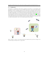
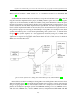
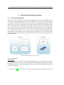
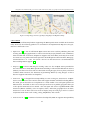
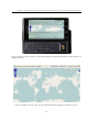
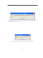
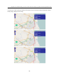
Using WFS-T in combination with geolocation for online transactional editing of geographic features through mobile browsers
greSQL with PostGIS is used as a datastore connecting to GeoServer
•
Test editing of geographic features through mobile browsers and analyze the results
1.2
Keywords
Geographic Information Systems (GIS), GeoServer, OGC web services, WMS, WFS, WFS-T, Mobile browser, Geolocation
1.3
Problem description
Recently, there are numbers of open source GIS applications that offer for free. Comparing to
proprietary software, the most advantage of using free software may be that it can help organizations to save their cost such as in licensing fees and upgrading fees. However, it may also
provide some disadvantages if we choose the wrong one that is not fit to our projects.
And nowadays, Web Map Server (WMS) is one of the most important services that has been
widely used in GIS systems. It allows users to request for geographic data which will return results as map images. Many GIS tools support WMS, while many of them do not support WFS-T.
However, one good obvious issue of WFS-T is that it supports not only all operations of a basic
WFS which allows users to get raw geographic features over the Internet, but also a transaction
operation which allows users to modify geographic features. This benefit makes some providers
and developers concern to implement WFS-T in their systems. Recently, there are some applications that already support WFS-T, by the way, many of them are not be able to run on mobile
devices. So, in this project, we are going to research about how WFS-T in combination with
a new technology like geolocation can be used together to perform editing of geographic features via mobile browsers on mobile phones and investigate advantages and disadvantages from
implementing it.
1.4
Justification, Motivation and Benefits
From the introduction and problem description above, since there are various GIS applications
provided for free as Open Source software, it is more comfortable for us to think about how we
can develop the prototype because we do not need to concern much about the implementation
cost in case that we choose to use Open Source tools.
At the present of time, many research papers have involved in WMS area. While some of them
have been related to WFS, few of them have mentioned about WFS-T especially how WFS-T can
work on mobile phones. Additionally, geolocation is a new technology released for awhile and
becomes helpful in GIS this days including in developing applications for mobile devices.
We can see that mobile phones have played important roles in our society which most people
have their own mobile phones. Not only we can use our mobile phones to talk or to send text
messages to our friends, but many modern mobile phones provide a service to access to the
Internet. So, if we can make use of this kind of technology in combination with WFS-T, it will help
to provide some useful information for those who are interested in using and/or implementing
WFS-T in combination with geolocation on mobile devices and will probably be able to enhance
functions and value of developing the applications in the near future.
4