1
Destinator ND
User Guide
Destinator ND User Guide
Notices, Disclaimers and Terms of Use
1. Limited Product Warranty. Homeland Security Technology Corporation (HSTC), warrants to the
Client that the Products shall substantially conform to HSTC’s specification for a period of one (1)
year from the date of the original purchase by the end user (the "Warranty Period"). As HSTC 's
sole obligation and Client's exclusive remedy for any breach of warranty, HSTC agrees, at its sole
option, to (i) use reasonable efforts to repair the Product with new or refurbished replacement parts;
(ii) replace the Product with a new or refurbished unit; or (iii) refund the purchase price, provided
Client returns the defective Products to HSTC with proof of purchase and HSTC’s authorization.
HSTC’s warranty hereunder does not apply in case of any damage caused by accident, abuse,
misuse, misapplication, or alteration of any kind performed by anyone other than HSTC. The
Products are not designed or licensed for use in mission-critical applications, or in hazardous
environments, requiring fail-safe controls, including without limitation operation of nuclear facilities,
aircraft navigation or communication systems, air traffic control, or life support or weapons systems.
Without limiting the generality of the foregoing, HSTC specifically disclaims any express or implied
warranty or condition of fitness for such purposes. HSTC’s warranty does not, in any event, apply to
physical damage to the surface of the Product or replacement. HSTC shall have no obligation with
respect to any data stored in the Product.
Except as expressly stated in this section, HSTC makes no warranties or includes any conditions
with respect to the products, express or implied, including, but not limited to, the implied warranties
or conditions of merchantability, fitness for a particular purpose and no infringement.
2. Liability Limitation. In no event shall HSTC, be liable to Client, (and Client hereby waives any
indirect, special, incidental, or consequential damages in connection with) the transactions
contemplated by this agreement, whether or not such damages were foreseen, or their likelihood
disclosed. HSTC shall not be liable to Client or any third party claiming through Client, for any
damages of any kind in excess of the amounts paid by Client under the terms of this agreement with
respect to the products giving rise to such damages. Some jurisdictions do not allow the exclusion
of or limitation on implied conditions, warranties or damages, thus some of the foregoing may not
apply to Client.
3. Intellectual Property Rights. Hardware and Software are proprietary to HSTC or its suppliers
and are subject to copyright and other intellectual property laws. Client's only rights with respect to
any HSTC software included with the Products shall be provided, under the terms of HSTC ’s
software license. Title to all HSTC Software remains with HSTC. Client agrees that HSTC retains
ownership of all rights, title and interest in all intellectual property, works of authorship, trade secrets
and like’s in all aspects of the Product(s). Client and its affiliates and subcontractors agree not to
reverse engineer any aspect of the Software and/or Products supplied under this agreement and
further agree to pay assessed damages should such action take place.
4. Copyright and Copies. The Software (including any copy thereof) is owned by HSTC or its
suppliers and is protected by United States, Canada, European, Brazilian and Australian copyright
and patent laws and international treaty provisions. The Software copy is licensed to you the client,
not sold to you, and you (the client) are not an owner of any copy thereof. You may make one copy
of the software for backup or archival purposes. You may not otherwise copy the software, except
as authorized by applicable law, nor the written materials accompanying the Software. HSTC
hereby reserves all rights not explicitly granted in this license agreement.
Copyright © 2004, HSTC.
November 17, 2005
Page 2 of 73
Destinator ND User Guide
Table of Contents
Chapter 1 – Welcome to Destinator ND
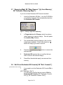
1.1 Introduction
1.2 Any turn is ok
1.3 Getting help
1.4 Technical Support
Chapter 2 – Hardware Installation
2.1 Introduction
2.2 Installing the BM6300T Navigation system in your car
Chapter 3 – Using Destinator ND Console
3.1 Menu and toolbar overview
3.2 Exit from Destinator ND console
3.3 Creating your own maps
3.4 Cut maps
3.5 Selecting pre-cut maps
3.6 Loading newly created maps
3.7 Removing maps from memory
3.8 Exit From Destinator ND console
Chapter 4 – Navigating a route
4.1 Introduction
4.2 Map description
4.3 The destination menu
4.4 Navigate to an address (or intersection)
4.5 Navigate to a POI (Point Of Interest)
4.6 Navigate to a Favorite
4.7 Save to Favorites
4.8 Navigate to a history item
4.9 Navigate to a point on the map
4.10 Trip Planning
4.11 Avoid Roads
Chapter 5 - Options
5.1 Introduction
5.2 The options menu
5.3 Show route
5.4 Driving directions
5.5 Turn by turn
5.6 Cancel route
5.7 Play
5.8 Switch maps
5.9 Travel mode
5.10 Help
5.11 About
Chapter 6 - Settings
6.1 Introduction
Page 3 of 73
5
5
6
6
6
7
7
8
9
9
11
11
12
14
18
19
19
20
20
21
24
25
28
30
31
32
33
34
37
38
38
39
39
39
41
41
42
42
42
43
43
44
44
Destinator ND User Guide
6.2 The settings menu
6.3 GPS status and settings
6.4 Home button settings
6.5 General settings
6.6 Map Settings
6.7 Route settings
6.8 Alert settings
6.9 Visual notifications
6.10 Look and feel
6.11 Device settings
Chapter 7 – Changing map views
7.1 Introduction
7.2 How to zoom and scroll
7.3 Types of view
Chapter 8 – Favorites and Speed Camera Alerts
8.1 Introduction
8.2 Configuring favorites alerts category
8.3 Speed camera options
8.4 How to tell if you have the latest speed camera database
Chapter 9 – FAQ (Frequently asked Questions)
Glossary
45
45
47
47
49
50
52
53
54
55
56
56
57
58
60
60
60
61
62
64
70
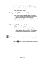
Note:
Some smaller (sub-) municipalities may not contain street data. In such cases, please
choose the larger (super-) municipality displayed in parentheses to search for these streets.
Alternatively, you can change the search order to Street>City or Zip/Postal Code>Street to
find street data for the smaller municipality.
Page 4 of 73
Destinator ND User Guide
11
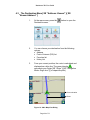
Welcome To Destinator ND
1.1
Introduction
The BM6300T is a full-featured mobile satellite navigation
system.
It utilizes GPS (Global Positioning System) satellites to
pinpoint your location utilizing the latest mapping data
technology to get you to your destination in the most efficient
and timely manner.
The Destinator ND software assists you in planning your
route and it provides Turn by Turn, Voice and Visual
instructions for getting to your destination.
1.2
Any Turn is OK
With Destinator ND, there is no such thing as a “wrong turn.”
You can deviate from the planned route at any time. For
example, you might want to avoid traffic, detour around road
blocks, or take an alternate route of your choice.
Destinator ND does not require that you turn around and go
back to the original route. Rather, Destinator ND will
calculate a new route to your destination using your current
position.
Page 5 of 73
Destinator ND User Guide
1.3
Getting Help{ XE "Help" }
An abbreviated Help file with basic Destinator ND
navigational definitions and instructions is available.
At the map screen, cycle to the Options Menu by pressing
the
1.4
button, and select.
Technical Support
If you have other questions about BM6300T Navigation
Device, please contact your supplier or Technical Support:
www.bluemedia-it.com or +49 (0) 700 - 32 79 22 73
[+49
(0) 700 – EASYCARE].
Evesham Support:
Internet: http://www.lowestonweb.com/destinator
E-Mail: [email protected]
Telephone: 09050200101 (25p per min)
Page 6 of 73
Destinator ND User Guide
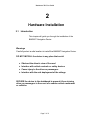
22
Hardware Installation
2.1
Introduction
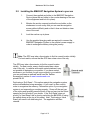
This chapter will guide you through the installation of the
BM6300T Navigation Device.
Warnings
Carefully select a safe location to install the BM6300T Navigation Device.
DO NOT INSTALL the device in any place that could:
♦ Obstruct the driver's view of the road
♦ Interfere with vehicle controls or safety devices
♦ Cause injury to the driver or passengers
♦ Interfere with the safe deployment of the airbags
SECURE the device to the dashboard to prevent it from injuring
driver or passengers in the event of a sudden vehicle movement
or collision.
Page 7 of 73
Destinator ND User Guide
2.2
Installing the BM6300T Navigation System in your car
1.
Connect the supplied car holder to the BM6300T Navigation
Device (place the car holder in the counter bearing on the rear
of the equipment and lock it in place).
2.
Moisten the suction cup and position the car holder on the
windscreen in such a way that you can see the navigation
screen without difficulty and so that it does not hinder a clear
view of the road.
3.
Lock the suction cup in place.
4.
Use the supplied charging cable as required to connect the
BM6300T Navigation System to the vehicle’s power supply in
order to recharge the battery during the journey.
Note: The GPS may take a few minutes to find its current location initially.
For best results, ensure that the GPS has a clear view of the sky.
The GPS may take a few minutes to find its current location
initially. For best results, ensure that the aerial has a clear
view of the sky. In vehicles with metal coated windows it may
not possible to determine your position. If you have coated
windows or you find that you get a poor signal in your vehicle
you can purchase an external aerial from the ‘SatNav
Accessories’ section of www.lowestonweb.com
priced £24.99
Performing a ‘Soft Reset’ - This option restarts the navigation system,
without reinstallation being necessary. A ‘soft reset’ is often used in
order to reorganize the memory. Choose this option if your navigation
system is not responding or working properly. Screw off the end cap
of the stylus and carefully press the point of the end cap into the Reset
opening on the left side of your device. If the ‘Soft Reset’ does not
work try a ‘Hard Reset’ this is done by switching the BM 6300 off using
the switch shown at the top of this sheet. Note: Performing a ‘Hard
Reset’ will result in all data being lost. The application will then
reinstall.
Page 8 of 73
Destinator ND User Guide
33
Using Destinator ND Console
Installing the Software on your Computer
The BM-6300 is supplied with 2 CD’s. One is “BM-6300 Support CD” the other is “Destinator ND”
The “BM-6300 Support CD” Must be installed first; this disc allows you to install Microsoft
Activesync. The Activesync software is required to allow the BM-6300 to communicate with your
computer when connected with the USB cable. The Activesync software must be installed before
connecting the BM-6300 to your computer.
You may now install the second CD “Destinator ND”. This CD contains the Destinator Console.
The Console can be used to pre-plan routes on your computer and is required if you ever need to
reload the software and maps to your SD card.
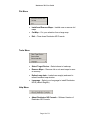
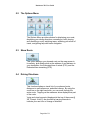
3.1
Menu and Toolbar Overview
Toolbar
Figure 1 - Destinator ND Console Toolbar
•
Install / Remove Map – Dual function of installing new or
self created maps or removing old not used maps to save
memory
•
Cut Maps – Allows you to create and cut own selection
of map(s)
Page 9 of 73
Destinator ND User Guide
File Menu
•
Install and Remove Maps – Installs new or remove old
maps
•
Cut Map – Cut your selection from a large map
•
Exit – Close down Destinator ND Console
Tools Menu
•
Select Target Device – Select where to load map
•
Remove Maps – Remove old or not used maps to save
on memory
•
Refresh map data – loaded new map(s) and need to
refresh Installed map window
•
Language – Select your Language to install Destinator
ND in (default English)
•
About Destinator ND Console – Software Version of
Destinator ND Console
Help Menu
Page 10 of 73
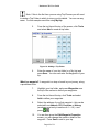
Destinator ND User Guide
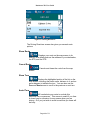
3.2
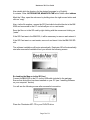
Exit from Destinator ND Console
1.
When you are ready to exit the Destinator ND
Console, click
File > Exit.
Figure 2 - Quit Destinator ND Pop-up
2.
3.3
You will need to confirm that you want to Exit. Press
Yes and you will exit from the Destinator ND Console.
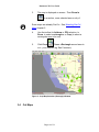
Creating Your Own Maps{ XE "Map: Creating" }
Living in California, but need only the map and driving
directions for San Francisco? Well Destinator ND has
made that easy with its simple to use Cut Map tool.
1.
From Standard Maps window select the map(s) you
wish to load by clicking on the map image or selecting
them from the list. (√) represents a selected map to
install.
2.
Press the Cut Map
button.
A Confirmation Dialog is displayed, press the OK
button to install the map(s), or the Cancel button to
exit map installation and return to select map(s). The
selected map is temporally loaded to hard disk.
Page 11 of 73
Destinator ND User Guide
3.
The map is displayed on screen - Then Zoom In
on a section, zone, selected area or city of
interest.
Some maps are already Pre-Cut. See Selecting Pre-Cut
Maps chapter 2.
4.
Use the toolbar for Address or POI selection, to
Zoom, to select a sub-region, or Crop (to select a
rectangular area to be cut).
5.
Click Crop
(Draws a Rectangle around area to
cut – your selection eg: San Francisco)
Figure 3 - Crop Map Selection (Rectangle) Window
3.4
Cut Maps
Page 12 of 73
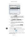
Destinator ND User Guide
1.
Click Cut Map{ XE "Create Map" }
to
create that selected zone (map){ XE "Zone: Selected"
}.
Figure 4 - Entering a New Map name Pop-up
2.
Enter a unique name as the new map name eg:
San_Frisco1.
Note: No spaces between words are allowed, but you can use
underscores to separate the words (16 characters maximum).
3.
Pressing Estimate gives the size of the selected map.
Do you have enough memory available? Click OK.
4.
Click Cut – To automatically store the newly cut map
on your computer.
Destinator ND creates a default directory on your
computer, C:\program files\New Maps, where all cut
maps are stored.
5.
Click OK. From Destinator ND Maps Cutter, click File
> Return to Console. (You are returned to the
Destinator ND Console).
To load map see{ XE "Load New Map" } Loading Newly
Created Maps{ XE "Load New Map" } to BM6300T
Page 13 of 73
Destinator ND User Guide
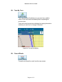
3.5
Selecting Pre-Cut Maps
Selecting by Address
1.
Select map{ XE "Map: Select" } to load from
Standard Maps, eg: Italy.
2.
Click Cut Map{ XE "Create Map" }
. The
selected map (Italy) is automatically loaded to hard
disk and displayed in the Map Cutter window.
Figure 5 - Pre-Cut Selection Window
Do you have a specific Address, POI or Region that
you need to map? On the In Destinator ND Cutter, on
the Toolbar select Address POI, zoom or subregion to Cut.
Page 14 of 73
Destinator ND User Guide
3.
If you have an address choose the Address
button, select by: City > Street and Home or City >
Intersection.
4.
Eg: City - Milano then Street and Home Giustiniano, Viale then click Show Address.
Figure 6 - Select Address Sub Region Window
5.
In the Destinator ND Map Cutter main view the map is
updated and selected area to be cut is centered and
marked.
6.
From Toolbar, click Crop
, select on the map
where to draw rectangular zone to be cut. (Move your
curser to the area marked and draw a box around the
previously marked area).
Page 15 of 73
Destinator ND User Guide
7.
Click Cut Map{ XE "Create Map" }
to cut the
selected zone{ XE "Zone: Selected" }. See Cut Maps
chapter 2.
Selecting Map by Intersection
Similarly If you need to select a map by Intersection.
1.
From Toolbar click Address, then click City >
Intersection.
2.
First, click City then the 1st Street and then
Intersection.
3.
From the list, click 2nd Street.
4.
The map view is updated and area to be cut is
centered.
5.
From Toolbar > Crop
, then on the map select
where to draw rectangular zone to be cut.
6.
Click Cut Map{ XE "Create Map" }
to cut the
selected zone{ XE "Zone: Selected" }. See Cut Maps
chapter 2.
Selecting Map by Points of Interest (POI)
1.
From the Toolbar click
2.
Select the POI eg: Golf Courses.
3.
Select your Golf Course. (Ensure that it is
highlighted).
Page 16 of 73
.
Destinator ND User Guide
4.
From Toolbar > Crop
. - On the map select,
with the mouse, where to draw Rectangular zone to
be cut.
5.
Click Cut Map{ XE "Create Map" }
to cut
selected zone{ XE "Zone: Selected" }. See Cut Maps
chapter 2.
Selecting by Sub Region
(If you are ready using the Destinator ND Map cutter see
step 3).
1.
On the Destinator ND Console select the main map{
XE "Map: Select" } to load from, eg: Italy.
2.
Click Cut Map{ XE "Create Map" }
Destinator ND Map Cutter is displayed.
3.
A list of sub-regions is, displayed on the right hand of
the selected map. Click on the sub-region to
download.
4.
Click Cut Map{ XE "Create Map" }
to cut
selected zone{ XE "Zone: Selected" }. See Cut Maps
chapter 2.
Page 17 of 73
. The
Destinator ND User Guide
3.6
Loading Newly Created Maps{ XE "Load New Map" } to
BM6300T
1.
On the Destinator ND Console, to refresh Standard
Map dialog, Click Tools > Refresh New Map Data.
2.
Select the map(s) you wish to load by clicking on the
map image or selecting them from the list. (√)
represents a selected map to install.
3.
In Target device, click Change to select where to
install the map(s). You can install to Main Memory,
Storage Card or Removable Disk (External Reader).
You are, prompted to select the target device where
maps are to be uploaded.
4.
Choose one (highlight) eg: Storage Card, click OK.
Confirm that there is enough memory to install map
in.
5.
Click
. A pop-up message
requiring confirmation appears.
6.
Press OK to load map.
Destinator ND Console will display a progress window
to let you monitor the installation’s progress.
7.
When the map installation has completed, a
Successfully loaded message appears. Press OK.
Page 18 of 73
Destinator ND User Guide
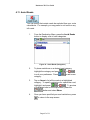
3.7
Removing Map{ XE "Map: Remove" }(s) from Memory {
XE "Software: Removing Maps" }
If you do not have Destinator ND Console launched:
1.
Insert the Destinator ND Disk 1, into the CD-ROM in
your desktop computer; this automatically launches
the Destinator ND Console.
Figure 7 - Change Target Device (Memory)
3.8
2.
In Target device click Change, select from where
(which memory) to remove map(s). This will update
the Installed Map Window.
3.
The Installed Map Window displays a list of all the
loaded maps available. Click in the check box (√)
beside the map(s) you wish to remove.
4.
Press the
selected map.
5.
Destinator ND requires that you confirm that you
wish to remove the selected map(s).
6.
Press Yes; the selected map(s) are removed from
memory.
button to remove the
Exit From Destinator ND Console{ XE "Exit: Console" }
{ XE "Destinator: Exit Console" }
1.
If you need to exit the Destinator ND Console File >
Exit.
{ XE "Destinator: Quit" }
You will need to confirm that you want to Exit the
Destinator ND Console.{ XE "Destinator Console:
Exit" } { XE "Destinator Console: Quit" }
Page 19 of 73
Destinator ND User Guide
2.
Press Yes and you will exit.
44
Navigating a Route{ XE "Route:
Setting" }
4.1
Introduction
This chapter will help you to define and plan a route{ XE
"Route: Planning of" }{ XE "Route: Defining" }. You will be
able to select a destination, set your origin, or plan a journey.
The route calculated in real time is from your current GPS
position.
There are several ways to configure your destination using
the Menu button (
). You can navigate to:
•
An Address
•
An Intersection
•
A Zip/Postal Code
•
A POI (Point Of Interest)
•
An Address in Favorites
•
An Address In History
Page 20 of 73
Destinator ND User Guide
4.2
Map{ XE "Button: Descriptions" } { XE "Icons" \t "See
Button Descriptions" }Description
There are various buttons and icons on the map screen that are
used to plan and view a route.
Driving Directions Button
Compass Button
View Selector Button
Current Location
Menu Button
Home Button
Battery Status
Indicator
Route DDetails Button
GPS-Generated
Statistics Button
GPS Status
Button
Length Scale Indicator
Figure 8 - Main Map View
Location Icons
(or
in Pedestrian Mode) shows your current location
while in Navigation Mode.{ XE "GPS: Current Position Icon" }
(or
in Pedestrian Mode) shows your last known GPS
location while in Navigation Mode. This is not your current
location, because there is no valid GPS information at this time.
(or
Mode.
in Pedestrian Mode) shows the Origin in Planner
See Section 6.7 Route Settings for descriptions of Navigation
Mode and Planner Mode.
Page 21 of 73
Destinator ND User Guide
Map Screen Buttons
Toggles between Turn by Turn details and a complete list of
Driving Directions.
Shows magnetic direction as you move.
Toggles between 2D, 2D Night, 3D and 3D Night views. The
icon indicates the next view to be displayed.
Indicates whether you are in Vehicle Mode (
) or
Pedestrian Mode (
). You can change modes by holding
down the button for several seconds, or by opening the Options
Menu and pressing either
or
. In Pedestrian Mode,
the navigation radius is restricted to 10 kilometres (6 miles).
Displays details about your route, such as ETA (Estimated
Time of Arrival), ETR (Estimated Time Remaining) and the
distance to your destination.
Displays GPS–generated information, such as altitude,
longitude coordinates, geographic position, current location,
altitude, and speed. The icon indicates the next item to be
displayed.
Displays GPS status, such as information about your satellite
fix, and the latitude, longitude and altitude of your position. The
icon appears green when there is a GPS fix, and red when there
is no GPS fix. Also provides a link to the GPS Settings screen.
Displays battery status. When the battery power is low, a
message box will appear.
Home Button - Calculates a route to a pre-set POI or
address.
Page 22 of 73
Destinator ND User Guide
Pressing the
button allows you to cycle to the Destination
Menu, the Options Menu and the Settings Menu as seen in
Figure 9.
Figure 9 - Menu Structure
Page 23 of 73
Destinator ND User Guide
4.3
The Destination Menu{ XE "Address: Known" }{ XE
"Known Address" }
1.
At the map screen, press the
Destination menu.
button to open the
2.
You can choose your destination from the following
options:
• Address
• Point of Interest (POI) list
• Favorites list
• History list
3.
From your current position, the route is calculated and
displayed as a blue line. The green triangle
represents your Origin{ XE "Origin" }{ XE "Navigation
Mode: Origin Icon" } (or departure point).
Current location
Route
Figure 10 - Main Map View Dialog
Page 24 of 73
Destinator ND User Guide
4.4
Navigate To An Address (or Intersection){ XE "Address"
}
When you navigate to an address, there are several ways of
defining your destination. You can navigate to a destination
by selecting an address, a zip/postal code, or an
intersection.
The Cross Region Navigation feature lets you navigate a
route that extends across more than one region / country.
This feature becomes available only when you have several
maps installed.
The default order for entering your destination is City ->
Street -> Number, but by clicking on the
button, you can
cycle through the different ways of specifying your address.
Click on this
button to change
your search type.
Figure 11 - Address Search Screen
Lets you search for an address by first entering the
City, then the Street, then the Number.
Page 25 of 73
Destinator ND User Guide
Lets you search for an address by first entering the
Street, then the City, then the Number.
Lets you search for an address by first entering the
Zip/Postal Code, then the Street, then the Number.
Lets you search for an address by first entering the
Street, then the Zip/Postal Code, then the Number.
Lets you search for an intersection by entering the
City, the first Street, then the intersecting Street.
For example, to navigate to an address using the City ->
Street -> Number search order:
1.
Press Region if you are navigating a route across
several maps. Highlight your selection from the list of
installed maps. (If only one map is installed, you will
not see the Region option.)
2.
Press City and use the keyboard to enter the first few
characters of the city name. The scroll list will update
accordingly. You can also change your keyboard from
uppercase to lowercase by pressing the
button.
3.
Press Street to display a list of street names for the
selected city{ XE "City: Find" }{ XE "City: Name" }.
Select the street{ XE "Street: Find" }{ XE "Street:
Name" } name by entering the first few characters or
by scrolling down the list (eg: Birch, Ave).
4.
Not all cities/towns are mapped to the street level. In
such cases, the software will display Street data not
found. You can still navigate to the city as selected.
5.
Press Number and enter the number using the
keyboard. Some numbers may not be available; in
this case you can still navigate to the correct street.
6.
Once you have entered your destination, there are
several options available on the toolbar found at the
top of the screen.
Page 26 of 73
Destinator ND User Guide
Calculates and displays your route, which
is shown as a blue line on the map. You are then
ready to go.
Shows the destination on the map and
displays its details.
Allows you to add the destination to your
Favorites Folder, or to set it as your Origin (Start
Point)
As you drive, Destinator ND provides you with turn-by-turn
voice and visual directions, letting you know when your next
turn is coming up until you arrive at your destination.
If you don’t know the entire name of a city or street, type in part of the
name and press the
button. This will display a list of all names
that match what you’ve typed in.
For more information on a City, Street or Number click
to display
details about the location, such as its city, street name, and latitude and
longitude coordinates.
Note:
Some smaller (sub-) municipalities may not contain street data. In such cases,
please choose the larger (super-) municipality displayed in parentheses to search for
these streets. Alternatively, you can change the search order to Street>City or
Zip/Postal Code>Street to find street data for the smaller municipality.
Page 27 of 73
Destinator ND User Guide
4.5
Navigate To A Point of Interest (POI){ XE "POI" }{ XE
"Point Of Interest" }
The Points of Interest (POI) list is a collection of potential
destinations of interest in predefined categories. POIs are
identified on the map by various icons (eg:
Restaurants).
POI navigation is especially handy when you need to find a
facility, attraction or amenity by category or type. For
example, you can ask Destinator ND to guide you to the
nearest bank, shop, hotel, restaurant, Petrol station, etc.
The Cross Region Navigation feature lets you navigate a
POI route that extends across more than one region /
Country. This feature becomes available only when you
have several maps installed.
1.
From the Destination Menu, press the POI button.
2.
Press Region if you are navigating a route across
several maps. Highlight your selection from the list of
installed maps. (If only one map is installed, you will
not see the Region option.)
3.
Press Categories and highlight your selection from
the list of POI categories. For example, we can
search for the nearest restaurant.
Figure 12 - POI Categories
Page 28 of 73
Destinator ND User Guide
At this point, you can display all the items within a category on the
map screen by tapping the “+” button beside any of the
categories.
Tap the 1 Icon to enable the POIs you wish to be displayed on
the map view while you are driving. (“eye open” = enabled)
4.
With Restaurants highlighted, tap Items to display a
list of Restaurants in your area. The POIs are listed in
order of distance. To sort them alphabetically, press
the
button.
5.
Highlight your choice and click
to calculate
your route. The route is shown on the map as a blue
line from your current GPS position.
6.
You can select
to preview your destination
on the map, or press
to add the destination
to your Favorites or to set it as your Origin (Start
Point). You can also select Settings to define your
Search Radius and Search Center.
As you drive, Destinator ND provides you with turn-by-turn
voice and visual directions, letting you know when your next
turn is due.
Page 29 of 73
Destinator ND User Guide
4.6
Navigate To A Favorite
You can select a destination from your list of stored
Favorites. (The next section 4.7 describes how to save an
item to your Favorites list.)
A Favorite is an address or destination previously stored by
you for quick and easy retrieval. You can also save, edit or
delete destinations from this folder.
1.
From the Destination menu, press the Favorites
button. Your list of Favorites categories is displayed.
2.
Highlight My Favorites and tap Items. A list of stored
items is displayed.
3.
Highlight your selection and click
to
calculate your route. The route is shown on the map
as a blue line from your current GPS position.
4.
You can also select
to preview your
destination on the map, or press
to edit or
delete your choice, or to set it as your Origin / Start
Point.
As you drive, Destinator ND provides you with turn-by-turn
voice and visual directions, letting you know when your next
turn is due.
Page 30 of 73
Destinator ND User Guide
4.7
Save{ XE "Save: Favorites" } to Favorites{ XE
"Favorites" }
When selecting a Destination which you may use regularly,
you can save it to your personalized Favorites list.
1.
At the map screen, press the
Destination menu.
2.
Select and specify your desired destination as
described previously, be it from Address, POI,
History or Contacts.
3.
To save the location in your Favorites folder, click the
button to open the
button and select Favorites. The ‘Edit
Item’ Properties screen is displayed.
Figure 13 - Adding an Item to Favorites
4.
Enter a name and comment that will help you
recognize the item in future.
5.
Enter a new category name (eg: Friends) or select an
existing one and press Save.
Your favorite destination has now been stored for future use.
Page 31 of 73
Destinator ND User Guide
4.8
Navigate To A History Item{ XE "History" }
History allows you to select an existing destination from a
list of previously traveled routes. The software automatically
stores the last few destinations in memory. As each new
route is added to the top of the list, the older destinations at
the bottom are erased.
Figure 14 - History List
1.
From the Destination Menu, press the History button
to display your list of previously traveled routes.
2.
Highlight your selected History item and click
to calculate your route. The route is
shown on the map as a blue line from your current
GPS position.
3.
You can also select
to preview your
destination on the map, or press
to add the
destination to your Favorites or to set it as your
Origin.
Page 32 of 73
Destinator ND User Guide
4.9
Navigate To A Point on the Map { XE "POI" }{ XE "Point
On the Map" }
You can navigate to any point on the map by tapping its
location directly on the map screen. This feature is especially
handy when you want to navigate to a specific point you see
on the map, but you don’t have its street address.
Dialog Box on the
Map Screen
Figure 15 - Map Cursor Dialog
1.
Use the stylus to scroll or drag the map to a specific
point, and then tap the desired location.
2.
A dialog box displays the address of that point, and
lets you select whether you want to navigate to it,
recalculate your route, add the point to your Favorites,
or set it as your Origin (if you are in Planner Mode).
3.
To clear the cursor dialog, just tap the screen again.
If you need to reset the point of Origin,{ XE "New Origin" } {
XE "Set: New Origin" }tap the map screen to open the
Cursor Dialog, and select Set As Origin. All new route
calculations will use this as the starting point, but only if you
are in Planner Mode. In Navigation Mode, your current
GPS location is always your Origin.{ XE "Start Point" }
Page 33 of 73
Destinator ND User Guide
4.10 Trip Planning{ XE "Trip Planning" }
Trip planning is useful when you have more than one
destination along your route. This process is similar to the
procedures used to enter or select a destination and initiate
navigation, except that you must be in Planner Mode.
When you press
, the Route is calculated in stages, from
the departure point to the first waypoint. Once you’ve reached the first
waypoint, the route is recalculated to the second waypoint, and then
recalculated to the third waypoint, and so on.
How to Use Trip{ XE "Trip" } Planning
Use the following method to plan a trip:
1.
Ensure you are in Planner Mode. To do this, press
the
button and cycle to the Settings Menu.
2.
Press Route Settings
mode.
3.
Press the
and select Planner
button to save and return to the map
screen.
4.
At the map screen, press the
Trip Planner
Page 34 of 73
button and select
from the Destination menu.
Destinator ND User Guide
Note: If this is the first time you are using Trip Planner you will need
to create a Trip Folder in which to store your trip details. You can use any
name. For this example we will be using My trip.
5.
From the tool bar at the top of the screen, click Tools
and select Add to create a trip folder.
Figure 16 - Adding a Trip Folder
6.
Enter the name of your trip folder (e.g. My trip) and
press Save. You can now enter the waypoints of your
trip.
What is a waypoint? A waypoint is a stop or break in your journey, along
a predefined route.
7.
Highlight your trip folder, and press Waypoints near
the top of the screen to define your waypoints.
8.
From the tool bar at the top, click Tools and select
Add to define your waypoints.
9.
Select the address of your first waypoint – this can be
selected from Address, POI, Favorites or History
(as shown previously in sections 4.4 – 4.6) – and
press
10.
.
You are then given the Edit Waypoint Properties
screen; you can change the name or details of the
waypoint. Press Save to add to your trip.
Page 35 of 73
Destinator ND User Guide
Repeat steps 6 to 9 to enter all the waypoints.
Figure 17 - Trip Planner and Waypoints Dialogs
11.
Select the Show
button to view the complete
route. The first part of the route is shown as double
blue lines. The remaining parts of the route are shown
in a series of single line vectors.
12.
Using
or
, you can
change the order of your waypoints to suit your
purposes.
13.
You can also click on Tools > Optimize, which will
automatically sort the waypoints for the most effective
and quickest route.
14.
To calculate the route, press Navigate
.
The route is shown as a blue line from your current
GPS position.
* Remember to change back to Navigational Mode. *
To do this, press the
Press Route Settings
button and cycle to the Settings Menu.
and select Planner mode.
See Section 6.7 Route Settings for a description of Navigation
Mode and Planner Mode.
Page 36 of 73
Destinator ND User Guide
4.11 Avoid Roads
You can specify that certain roads be excluded from your route
calculations. For example, you may prefer to not travel on any
toll roads.
1.
From the Destination Menu, press the Avoid Roads
button to display a list of road categories.
Figure 18 - Avoid Roads (Categories)
2.
To place restrictions on a desired road category,
highlight the category and press
to suit your preference. Press
category.
3.
or
to add a new
Tap on Items to list all the roads in a highlighted
category. To specify restrictions for a particular road,
highlight it and press
or
. To preview
a highlighted road on the map screen, press the
button and select Show.
4.
Once you have specified your road restrictions, press
to return to the map screen.
Page 37 of 73
Destinator ND User Guide
55
Options
5.1
Introduction
There are various route and map options available from the
Options Menu.
This chapter contains the following topics:
•
•
•
•
•
•
•
Showing your Route
Displaying Directions
Canceling your Route
Recording and Playing Back a Route
Switching Maps
Selecting Travel Mode
Getting Help
Page 38 of 73
Destinator ND User Guide
5.2
The Options Menu
The Options Menu provides choices for displaying your route,
displaying your driving directions, canceling a route, playing
and recording a route, switching maps, selecting your mode of
travel, and getting help with basic navigation.
5.3
Show Route
This option displays your planned route on the map screen in
its entirety, plus details such as the address of and distance to
your destination, the Estimated time of arrival (ETA), and the
Estimated time remaining (ETR)
5.4
Driving Directions
This function displays a visual list of your planned route,
distances to each maneuver, and street names. By using the
scroll bar on the right hand side, you can scroll through the
entire route. Tapping on the maneuver twice displays that part
of the route.
Voice and visual prompts (displayed at the top of the screen){
XE "Prompt: Voice" } are provided at varying intervals to
indicate your next turn or change of direction.
Page 39 of 73
Destinator ND User Guide
Figure 19 - Driving Directions
The Driving Directions screen also gives you several route
options:
Show Route
Displays your route on the map screen in its
entirety, plus details such as the address of your destination,
the ETA, and the ETR.
Cancel Route
Cancels and clears the route from the map
screen.
Show Turn
Displays the highlighted portion of the list on the
map screen, including the street name, distance to it, and an
arrow diagram to indicate the turn. You can also use the
Prev and Next arrows to scroll to the previous or next turn.
Avoid Turn
Will recalculate your route to exclude this
particular turn or maneuver. This comes in useful if you face
a closed road or diversion for any reason when you are
driving. Or if you just wish to avoid a road that you know will
be busy.
Page 40 of 73
Destinator ND User Guide
5.5
Turn By Turn
This view indicates the distance to your next turn, and the
name of the next street immediately after completing the
previous turn.
Voice and visual prompts are displayed at varying intervals to
indicate your next turn or change of direction.
Figure 20 - Turn by Turn Dialog
5.6
Cancel Route
Cancels and clears the route from the map screen.
Page 41 of 73
Destinator ND User Guide
5.7
Play
This feature allows you to record your route as you’re traveling,
and then to play it back on the map screen at a later time.
From the Play/Record screen, you can record a route, play
back a route, change the speed of the playback, and delete
recordings. Pressing
5.8
returns you to the map screen.
Switch Maps
This feature lets you switch between your maps. The Switch
Maps screen also displays details and version numbers of your
maps, and allows you to delete maps. This feature is only
required when you have more than one map installed on your
SD card.
5.9
Travel Mode
You can further define your route according to whether you are
traveling by car or on foot. This button lets you switch to
Pedestrian Mode or Vehicle Mode. In Pedestrian Mode, the
navigation radius is restricted to 10 kilometres (6 miles). The
route calculated in pedestrian mode will exclude roads that are
not suitable for pedestrians or cyclists such as motorways.
Page 42 of 73
Destinator ND User Guide
5.10 Help
This button launches an abbreviated help file with basic
navigational definitions and instructions.
5.11 About
Displays software version and details about your Destinator ND
application.
Page 43 of 73
Destinator ND User Guide
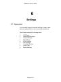
66
Settings
6.1
Introduction
You can easily change the default settings of maps, views
and route parameters to suit your personal preferences.
This chapter contains the following topics:
•
•
•
•
•
•
•
•
•
GPS Status
Home Button Settings
General Settings
Map Settings
Route Settings
Alert Settings
Visual Notifications
Look & Feel
Device Settings
Page 44 of 73
Destinator ND User Guide
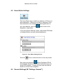
6.2
The Settings Menu
The Settings Menu allows you to change the settings which
determine how your route is calculated or displayed.
6.3
GPS{ XE "GPS: Status" }{ XE "GPS: Settings" } Status
And Settings
{ XE "Settings: GPS" }
Destinator ND uses GPS signals to pinpoint your location. In
Navigation mode, the software automatically acquires GPS
signals and constantly updates your vehicle's location and
position. The GPS may take a few minutes to find its current
location initially. For best results, ensure that the GPS has a
clear view of the sky. In most cases you cannot receive a
GPS signal while indoors or underneath any solid object.
Page 45 of 73
Destinator ND User Guide
Figure 21 - GPS Status Screen
To view your GPS configuration, click on the
button. You can access this button via the Settings Menu >
GPS Status, or by clicking on the
screen.
button on the map
Figure 22 - GPS Settings Dialog
GPS Settings Configuration menu:
1. COM Port{ XE "Com Ports" } - Defines the
Communications Port.{ XE "GPS: Ports" }
2. Baud Rate - Transmission rate of data.{ XE "GPS: Baud
Rate" }
3. Protocol{ XE "GPS: Protocol" } - Default is NMEA.
Find GPS – Searches for and locates the GPS signal.
Set GPS - { XE "GPS: Check" } Sets the GPS Configuration.
Press the
button to save your selections and return to
the GPS Satellite graphic screen.
The GPS settings for the BM6300 are pre configured and
therefore should not need changing unless there is a
problem.
Page 46 of 73
Destinator ND User Guide
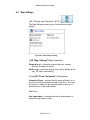
6.4
Home Button Settings
The Home Button lets you define an address or POI as your
home destination. Whenever you want to navigate to your
home destination (for example, the nearest gas station or
your work address), press the
navigation / map screen.
button found on the
In the Home Button Settings screen, select either POI Mode
or Address Mode to set your desired destination.
Figure 23 - Home Button Settings Screen
Press the
button to save and return to the map screen.
Now, when you press the
button, Destinator ND will
automatically calculate a route to this destination from your
current GPS position. It makes life very easy and offers a
simple one touch home navigation.
6.5
General Settings{ XE "Settings: General" }
Page 47 of 73
Destinator ND User Guide
The General Settings screen allows you to choose the unit
of measurement for your route.
Figure 24 - General Settings Dialog
{ XE "Settings: Units" }All distances are displayed in imperial
or metric units.
1. Imperial (Miles and yards) This is the default setting for
UK and Ireland.
2. Metric (Kilometers and meters)
Press the
button to save your selection and return to the
map screen.
Page 48 of 73
Destinator ND User Guide
6.6
Map Settings
{ XE "Settings: Map Orientation" }{ XE " }
The Map Settings screen lets you customize your map
display.
Figure 25 - Map Settings Dialog
{ XE "Map: Settings" }Map Orientation
Forward is up – orients the map so that your forward
direction is always at the top.
North is up – orients the map so that north is always at the
top.{ XE "Map: Information" }
Zoom{ XE "Zoom: Automatic" } Mechanism
Automatic Zoom – ensures that the zoom will return to its
previous level after several seconds of inactivity. The map
will zoom out when you are traveling faster to give you a
clearer picture of the roads ahead.
Map Font
Use large labels – increases the size of street names to
make the map easier to read.
Page 49 of 73
Destinator ND User Guide
Press the
button to save your selections and return to
the map screen.
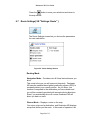
6.7
Route Settings{ XE "Settings: Route" }
The Route Settings screen lets you choose the parameters
for route calculation.
Figure 26 - Route Settings Screen
Routing Mode
Navigation Mode – Provides voice & Visual instructions as you
drive.
This mode is the one you will use most frequently. Destinator
ND uses the satellite-based global positioning system (GPS) to
constantly detect your current position. As you drive, your
location is compared to the destination you have chosen and
you will be constantly provided with accurate driving directions.
Even if you accidentally drive off course, Destinator ND will
direct you back on track.
Planner Mode – Displays a route on the map.
You set an origin and a destination, and Destinator ND displays
a map that shows you the route. In this mode of operation, the
Page 50 of 73
Destinator ND User Guide
satellite-based global positioning system (GPS) is not used.
Your current position is not detected and Destinator ND does
not keep track of your driving progress. Use Planner Mode for
trip planning.
{ XE "Origin: Planner Mode" }
Route generation{ XE "Route generation" }
{ XE "Route: Quickest" }Quickest route{ XE "Quickest
route" } – Destinator ND calculates the route by picking
the shortest distance and highest speed limits.
{ XE "Route: Shortest" }Shortest route{ XE "Shortest route"
} – Destinator ND calculates the route by picking the
shortest distance.
U Turn Usage{ XE "Route generation" }
{ XE "Route: Quickest" }U Turn enabled - If you select this
option, the route will be calculated by including any U
Turns that are needed. If you clear this option, the route
will be calculated without any U Turns. (This feature is
included because some drivers prefer not to make U
Turns.)
Note: Route generation excludes any detours, stops or delays along the
route.
Press the
button to save your selections and return to the
map screen.
Page 51 of 73
Destinator ND User Guide
6.8
Alert Settings{ XE "Settings: Alert" }
This screen displays warnings and alerts which, when
selected will provide voice prompts.
Figure 27 - Alert Settings Dialog
Voice Prompts
Speed{ XE "Speed" } Limit - Gives you a voice prompt
when your car exceeds the speed limit on this section of
the road.
Route{ XE "Route: Recalculation" } Recalculation{ XE
"Recalculation of Route" } - If you deviate from the
original route, Destinator ND automatically recalculates a
new route and updates ETA and distances. You will be
given a voice prompt when the new route has been
calculated
Low Signal{ XE "GPS: Signal" } - Warns that you are in
an area of low GPS signal. This is normally caused by
not having a clear view of the sky due to obstructions
such as tunnels or heavy tree cover.
GPS Not Found{ XE "GPS: Not Found" } - Alerts you if
the GPS signal is lost, or if power is removed from the
GPS receiver. This is normally caused by not having a
clear view of the sky due to obstructions such as tunnels
or heavy tree cover.
Page 52 of 73
Destinator ND User Guide
Drive Carefully - Friendly reminder at the start of each
journey.
Press the
button to save your selections and return to the map screen.
Page 53 of 73
Destinator ND User Guide
6.9
Visual Notifications
The Visual Notifications screen lets you choose how
Destinator ND notifies you of your upcoming turns.
Figure 28 - Visual Notifications Screen
1. Text – Visual notification is displayed in written form.
2. Symbols – Visual notification is displayed in pictorial
form (as an arrow diagram).
3. None - No visual prompts are displayed.
Press the
button to save your selections and return to
the map screen.
Page 54 of 73
Destinator ND User Guide
6.10 Look & Feel
The Look & Feel screen allows you to customize the sound
and appearance of Destinator ND.
Figure 29 - Look & Feel Screen
Voice Prompts – Default or change to different voice.
Skin – Default skin or different skins.
Press the
button to save your selections and return to
the map screen.
Page 55 of 73
Destinator ND User Guide
6.11 Device Settings
You can configure BM6300T device settings and check the
power remaining in the rechargeable battery at any time by
clicking on the
button.
Brightness: This screen contains two setting options. By
sliding the Brightness arrow up and down, you can select
how bright the screen will be.
In addition, you can use the Sleep Time pull-down menu to
cause the screen to turn off after a length of time during
which the device has not been used. This feature lets you
conserve battery power. If you select the “infinity” setting, the
screen will always remain powered up.
Calibration: This screen lets you recalibrate the touch
positions on the screen. You need to recalibrate if you
perform a hard reset. Using the stylus or a pointed object,
tap on the centre of the five cross positions as they appear.
Power Status: This screen displays how much power
remains in the battery. You might consider recharging the
battery if the level displayed is too low.
Date/time: This screen contains three settings. The Time
Zone setting lets you select which GMT (Greenwich Mean
Time) zone you are located in. A GMT zone is stated as
GMT plus a positive or negative offset.
The Date setting lets you select the current month and day.
The Time setting lets you select the current hour, minute,
and second. To configure the time, highlight one part of the
displayed time and tap on the up and down arrows to adjust
it.
Page 56 of 73
Destinator ND User Guide
77
Changing Map Views{ XE "View:
Changing Map View" }
7.1
Introduction
You can change your view of the map, and the way in which
the map is displayed on the screen.
This chapter contains a description of the following topics:
•
•
•
How to Zoom and Scroll
Types of Views
Day or Night Mode
Page 57 of 73
Destinator ND User Guide
7.2
How to Zoom and Scroll{ XE "Zoom" } { XE "Route:
Zoom" }
Figure 30 - Main Map Screen
With Automatic Zoom selected (Settings Menu > Map
Settings button) you can use the zoom buttons to override
the auto zoom, but the zoom will return to its previous level
after several seconds of inactivity.
When Automatic Zoom is not selected, you can zoom in or
zoom out manually and it will remain at that level.
You can scroll the map by holding your stylus on the screen,
and dragging the image in any direction.
Page 58 of 73
Destinator ND User Guide
7.3
Types of View{ XE "View: Types" }
The
button on the map screen toggles between 4 types
of views: 2D, 2D Night, 3D and 3D Night. The icon indicates
the next view to be displayed.
2D{ XE "2D View" } View{ XE "View: 2D" } { XE
"Map}
The 2D view is a straight-forward two-dimensional view.
This is the default map view. In this view, the map is
dynamically updated, and allows for manual panning and
zooming.
2D Night View
This is a high contrast, two-dimensional view, optimized for
night driving or adverse weather conditions. The map is
dynamically updated, and allows for manual panning and
zooming.
Figure 31 - 2D Night View
The route, start point and destination (outlined in blue) are
clearly visible under a variety of weather and driving
conditions.
Page 59 of 73
Destinator ND User Guide
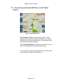
3D{ XE "3D View" }{ XE "3D View" } View { XE
"View: 3D" }
The 3D view is a simplified three-dimensional view showing
the map in a basic 3D relief. It shows the basic relief
(outline) and details of the surrounding roads and general
area.
Current
location
Figure 32 - 3D View
3D Night View
The 3D night view is a simplified three-dimensional view with
high-contrast colorization optimized for night driving or
adverse weather conditions.
Current location
Page 60 of 73
Destinator ND User Guide
Figure 33 - 3D Night View
Page 61 of 73
Destinator ND User Guide
88
Favorites & Speed Camera Alerts
8.1
Introduction
A Favorites Alert refers to an item that you can configure so
that Destinator ND will alert you when you are within a
certain distance of the item’s location. You can configure two
distances for the Automatic Alert. Destinator ND will first
alert you when you are within the first distance and then alert
you when you are within the second distance.
8.2
Configuring Favorites Alerts Category
Note that this configuration is applied to all items in the
category.
1.
From the Destination screen, select Favorites.
2.
Highlight the folder you want to configure and select
Edit… from the Tools menu at the top.
3.
To enable both alerts, check both boxes. Or, you can
disable one of the alerts by clearing the box next to it.
If you configure two alerts, the first one must have a
greater distance than the second one.
4.
From the pull-down menus, select a distance for each
enabled alert. Destinator ND will alert you when the
distance between your current traveling position and
the location of the alert equals the distance you enter
here.
5.
Close the Edit menu.
Page 62 of 73
Destinator ND User Guide
8.3
6.
To display Favortes on the map when you drive and
to be given a visual and audible alert you must tap the
1 Icon next to the category. When the eye is
shown as open the favorite will be shown on the map
and
7.
Select Save to complete the configuration.
Speed Camera Options
Press the
In the
button to cycle through the menu system.
section you will see a list of the different types of safety camera
1
Tap the
image next to the type of camera you wish to be alerted to. If the
‘eye’ is shown as open you will be alerted.
Tap the
icon, and then select settings from the drop down menu.
Select the distances at which you will be alerted to the safety cameras. Then tap
the ‘Save’ button. Once this is done you will receive an audible and visual
warning when approaching the selected safety camera types.
Now press the
button on the BM 6300 to return to the main navigation
screen. It is normal for the device to take while to exit the ‘favorites’ screen the
first time it is accessed, this is due to the amount of data that is being processed.
Register your product at www.lowestonweb.com/destinator to receive 6 months
free Safety Camera Database updates. After the first 6 months an annual
subscription of £30 is required to continue receiving updates. Subscription users
will also have access to a lower rate technical support line. Once registered you
will be notified by email when safety camera updates are released. Also
available for download along with the updated speed camera database will be a
separate Camera Updater application to be installed on your PC. This is
supplied with its own user guide once downloaded.
Page 63 of 73
Destinator ND User Guide
8.4 How To Tell If You Have The Latest Safety Camera Database
•
Switch on the Evesham Bluemedia BM-6300
•
Press the
•
Now using the stylus tap the
•
Tap one of the Camera categories, it does not matter which one but it will
be quicker to tap the ‘Temp Camera’ category as there is less data to
process. The selected category will now be highlighted in blue.
•
With the selected category still highlighted tap the ‘Items’ button at the top
right corner of the screen. You will be presented with a list of cameras.
•
Now tap the
button at the top right corner of the screen. You will be
presented with an ‘Information’ screen
•
Beneath the ‘Name’ will be a date (month and year) such as ‘July 2005’
this is the release date of the safety camera database on your device.
See below for an example of what the screen will look like.
button once
button on the screen
Page 64 of 73
Destinator ND User Guide
•
Compare the release date on the information screen with the release date
of the latest updated safety camera database on the website
(www.lowestonweb.com/destinator) to see if you are using the latest
version.
•
If your Information screen does not list a date it may say ‘Evesham
Technology’ or ‘www.lowestonweb.com/destinator’. In this case your
camera data is older than July 2005 and should be updated.
•
Press the
•
To update your files please follow the instructions available at
www.lowestonweb.com/destinator
button 3 times to return to the main navigation screen.
Page 65 of 73
Destinator ND User Guide
9
FAQ (Frequently Asked Questions)
1. Charging
2. Battery Life
3. Getting a signal
4. Addresses
5. Missing Roads
6. Using Points of Interest (POI)
7. Speed Cameras
8. Trip Planning (multi-stop)
9. Favourites
10. Resetting
11. Spares and Accessories
12. Reinstalling the SD card
1. Charging
When your Bluemedia arrives it will come turned off, to save battery power. First of all,
charge the Bluemedia until the charge indicator (top left corner) shows green. Then you
can switch it on with the small slide switch on the rear left bottom corner.
The Bluemedia will then turn on and install Destinator ND.
2. Battery Life
Charging time is four hours, and the battery lasts roughly four hours depending on GPS
usage. When not in use the unit can be left connected to the mains to keep the battery
charged and therefore avoid data loss.
3. Getting a signal
Start by going outside. The Bluemedia will take anything up to 10 minutes on its first
start-up to find satellites and orientate itself. Usual time to acquire satellites is around 3-6
minutes from switch-on.
Once it has a signal from a number of satellites, the map will refresh and show your
current location. You can zoom in and out with the magnifying glass buttons on the right
of the screen to show your local area. You can view the signal strength by tapping the
satellite dish symbol on the bottom right corner of the touch screen. This window shows
a ring of satellites, with a green line representing the signal strength.
You need four satellites.
Nearby skyscrapers, large buildings and a roof overhead will obscure the signal. Your
car is usually fine as long as you mount the Bluemedia in the front windscreen.
However, some cars have a heated or UV coated front windscreen. In some cases this
can obstruct the signal. You may need an external antenna if this is the case, but try it
Page 66 of 73
Destinator ND User Guide
first. Antennas can be purchased from www.lowestonweb.com, in the PDA/SATNAV
section.
4. Addresses
In principle, the Bluemedia always knows where you are, as long as you have a signal.
So, all you need to do is tell it where you’re going to.
To enter a destination, press the Flag button once, and choose Address. This will give
you the common address entry window.
At the top, it asks for City, Street, Number. At this point, city will be highlighted, so you
need to type in the city (or village/town) you wish to go to. The first few letters of the city
name will sort the list and you should be able to choose the correct city. Then, tap Street
and it will list all the streets in that city. Again, type in the first few letters of the street
you’re looking for. Once it’s listed, you may also specify a street number but this is often
not necessary. Tap Navigate at the top corner to plot the journey and start driving. This
will return you to the main map window, displaying a thick blue line representing the
route the device is going to guide you on. At this point, walk or drive off and the device
will begin giving verbal and visual direction instructions.
5: Missing Roads
A common question on the GPS helpline is “My road isn’t listed!”
The rule of thumb regarding this is, if you can see the road on the map (when you zoom
in), then it will be on the address list somewhere.
Try:
• Searching by postcode*, then street
• Searching for the street name, then list what cities that road appears in and pick
the likely candidate
• Searching for the village/borough/district as the city, and then street.
You can cycle though the various address input formats with the house symbol,
underneath City-Street-Number. The options are:
City-Street-Number
tap in your city, then choose street and pick your street
Street-City-Number
tap in the street you want, then choose city to list all the
cities/towns/villages which that street exists in
tap in the first part of the postcode and then choose street
Postal Code-Street
Street-Postal Code
City-Street-Street
tap in the street name and choose Postal Code to see a list
of which Postcodes the street appears in
Insert your city/town/village and then two names of roads,
and Destinator will guide you to the junction of those roads
6. Using Points of Interest (POI)
The Bluemedia has the capability to list various useful sites within the local area. These
are handy if you’re somewhere unfamiliar and you need to find a petrol station, or
railway station nearby. It can also plot these as symbols on the map.
Example: it would be useful to see petrol stations on screen.
Tap the flag button, choose POI. Scroll down the list to Petrol/Gasoline Stations. If you
click the Eye symbol, the map will now display all petrol stations. If you tap the +
Page 67 of 73
Destinator ND User Guide
symbol, you will get a list of the various petrol ‘brands’, and you can specify which petrol
stations appear on the map by setting the desired ones with the eye symbol. You could
ask it to just show Tesco or BP stations, for instance.
Scroll down to Tesco and tap it to highlight it in black. If you now tap Items at the top, it
will list all the local Tesco petrol stations, closest ones first. Choose a station and tap
Navigate for the Bluemedia to plot a route to it.
Destinator will not verbally alert you when you approach a POI unless It is set as a
destination.
7. Speed cameras
Speed cameras are located by means of a database of camera positions superimposed
on the map. This is similar to Destinator’s ability to locate POI’s-petrol stations etc. The
speed camera database can (and should) be updated regularly over the web, from
www.lowestonweb.com/destinator. This service is free for 6 months, after which a £30
per year subscription charge will apply. If you find the Bluemedia says nothing when
approaching a speed camera, you may need to update.
For those customers with the Destinator product including European maps, the speed
camera data is not included for countries other than the UK for legal reasons.
The method for performing the update is given as a guide on the web page.
Please make sure the speed camera types are listed in Favorites with open eye symbols
against each one.
Tap the Flag button, then Favourites, and they should all be listed.
You are able to set the warning distances here by choosing a camera type, tapping the
Tools menu, then Settings. You can choose a distance in yards at which Destinator will
announce a speed camera, and a second warning distance too. The default is the first
warning at 400 yards and another at 100 yards.
8. Trip Planning (multi-stop)
This is a feature otherwise known as ‘multi-stop’. Useful for couriers or for long journeys
with several stops, it allows you to create trips which include several destinations.
The Trip Planner consists of a list of Trips and a list of Waypoints.
You can pre-program Destinator with, for example, trips called Monday, Tuesday,
Wednesday; or with a trip called ‘holiday’. To each Trip you can add as many waypoints
(stops) as you need.
Use the Tools menu/Add feature to add a location to the waypoints list once you’ve
created a trip.
On the tools menu is also an Optimise feature which can re-arrange the Waypoints list in
the most economical route, closest waypoint first.
9. Favorites
The Favorites section is useful for adding regularly-used addresses. They can be
organised into your own categories. Already listed should be My Favourites.
You can add your own of course: such as Family, Friends, or perhaps branches of your
company.
Page 68 of 73
Destinator ND User Guide
You can add a category by tapping the Tools menu and choosing Add. Tap a name for
your category (“friends”, for example) and also you can choose a picture. Tap Save
when finished.
To see what addresses are stored under a category, tap the category name and tap
Items at the top. You cannot add a favourite address here.
Highlight an address and tap Navigate to start a journey.
To add an address to a category, press the Back (<-) button to exit back to the
Destination window, and then choose Address. Find your address as normal, but
instead of tapping Navigate, choose Tools, then Favourites. You may then tap a name
for the address (such as “Steve’s house”), an optional comment, then choose the
category you want to add it to (such as “friends”).
10. Resetting
Should you ever run into a problem with the software, there are 2 methods of resetting
the unit. The soft reset (no data will be lost) is performed by unscrewing the top of the
stylus and poking the reset button next to the SD card slot on the side of the unit.
A Hard reset (resulting in saved data being lost) is performed by moving the switch on
the back of the unit to the ‘off’ position for 10 seconds and then moving back to ‘on’.
11. Spares and Accessories
The following spares are available on www.lowestonweb.com
European map upgrade on 2 CDs (includes EU version of Console)
Spare car mounting kit
PNA cradle
Spare USB Sync Cable
Spare car charger
Spare mains charger
Stylus 3 pack
Textile Carry Case
External Antenna
Vent Mount
Leather Case
SD cards
12. Reinstalling the SD card
You may need to reinstall the data to your SD card if there has been a problem or it may
be that you have purchased a new SD card with more capacity. You will need to install
both the application and maps to the SD card.
Please follow the following steps to do this:
Place the Destinator ND CD-Rom in your PC’s DVD/CD drive.
Open the file structure of the CD using the file explorer.
Search for the “QuickInstall” directory and open it with a double click.
Page 69 of 73
Destinator ND User Guide
Now double click the directory for the desired language (e.g. English).
It contains 3 files: AUTORUN.EXE, MNAVDCE.CAB and a folder called addons
Mark the 3 files, open the sub-menu by holding down the right mouse button and
click on “copy”.
Now, via the file explorer, access the SD Card which should either be in the BM
6300 and connected to the PC via ActiveSync or in a card reader.
Save the files on to the SD card by right clicking with the mouse and clicking on
“paste”.
If the SD Card was in the BM 6300, it will be necessary to remove and reinsert it.
If the SD Card was in a card reader, remove it and insert it into the BM 6300 SD
slot.
The software installation will begin automatically. Destinator ND will automatically
start after successful installation and you will see the following screen:
Re-Loading the Map on to the SD Card
Connect the BM 6300 to the PC via the USB cable included in the package.
Ensure that ActiveSync has been installed on your PC (see “Installing Software
on your computer” section)
You will see the following screen after successful connection:
Place the “Destinator ND” CD in your DVD/CD drive.
Page 70 of 73
Destinator ND User Guide
Open The Destinator console on your computer
All of the maps available on the Destinator ND CD will be shown in a map
overview and in a list showing the memory required for each map.
To save a map to the SD-Card you must initially choose the target device where
you
would like to install the material in the Destinator console.
You can choose a target device by clicking the CHANGE button at the bottom left
of the screen: either a memory card in your PC, an SD-Card in a removable
device or the SD-Card in the BM 6300 (the device must be connected to the PC
via Active Sync).
Now highlight the map you would like to install by clicking on it and then click on
the “Install/Remove Maps” button. The map material will now be transferred to
the SD-Card.
After successful transfer, Destinator ND and the map material will be ready to
use.
The SD-Card must be inserted into the BM 6300’s SD slot.
Page 71 of 73
Destinator ND User Guide
Glossary{ XE "Glossary" }
This glossary describes terms and abbreviations used with Destinator ND.
Abbreviation
Name
Description
COM PORT
Communications
Port
In Computer systems, the name of a
serial communications port - Eg: COM1,
COM2, COM3, and COM4.
EULA
End-User License
Agreement
Is a legal contract between a software
application author or publisher and the
user of that application. The EULA, often
referred to as the "software license," is
similar to a rental agreement; the user
agrees to pay for the privilege of using
the software, and promises the software
author or publisher to comply with all
restrictions stated in the EULA.
ETA
Estimated Time of
Arrival
ETR
Estimated Time
Remaining
FAQ
Frequently Asked
Questions
Global Positioning
System
The estimated time to complete the
journey, if we where to leave now.
Excluding any detours, stops or delays
along the route.
The estimated time remaining to
complete the route. Does not allow for
any delays.
A list of Frequently Asked Questions with
Answers.
The GPS (Global Positioning System) is
a "constellation" of 24 well-spaced
satellites that orbit the Earth and make it
possible for Vehicles/ people/ assets
enabled with GPS receivers to pinpoint
their location.
An imaginary parallel circular line (East /
West) around the earth, the same
distance, north or south from the equator
– expressed in degrees.
An imaginary circular line on the surface
of the earth passing through the North
and South poles at right angles to the
equator - expressed in degrees.
Path or trajectory of a body through
space. A GPS satellite traces out an
orbit about the earth.
A place or item of interest along the
GPS
Lat
Latitude
Long
Longitude
Orbit
Orbital path of a
Satellite
POI
Point Of Interest
Page 72 of 73
Destinator ND User Guide
Abbreviation
Name
Sat
Satellite
See also GPS
SD
Secure Digital
memory card
TTD
Total Time
Duration
Description
selected route.
A man-made object, or device that orbits
the earth. Eg: a GPS Satellite which
orbits the earth in a fix pattern, height
and speed
A Secure Digital (SD) card is a tiny flash
memory card used to make data storage
portable among various devices.
The projected total time the trip is
calculated to take - does not allow for
any detours or other delays.
Page 73 of 73