1
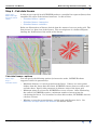
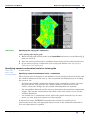
INTREPID User Manual
Library | Help | Top
Multi-scale edge detection wizard (T44a)
50
| Back |
Now we have a set of viable conditions to create a 3D fault surfaces, directly from the
wormE tool, with an ability to verify the spatial 2D relationships, as traditionally
done using a GIS, with the full power of a 3D fault network interpretation.
So, in a short form explanation, compute the geology model Model>Compute, then
choose Faults Only. select all contacts.
Display the topographic expression of the faults. Model > Plot the model settings
Library | Help | Top
© 2012 Intrepid Geophysics
| Back |