1
INTREPID User Manual
Library | Help | Top
Multi-scale edge detection wizard (T44a)
44
| Back |
Structure of Worm3D surface datasets
Parent topic:
Specifying input
and output files
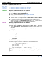
INTREPID performs cluster analysis on each ‘worm’ at the highest continuation level
to produce a family of related interface points, foliations and limited fault extents
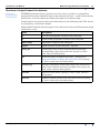
estimated from each cluster. In the output 3D surface dataset, part A is for interface
points, part B is for foliations and part C is for fault limited radii.
•
A - Output interface points have the fields “ContactNumber, X,Y,Depth,Anomaly”
shown in the following example.
// Intrepid WormE 3D contacts, Projection: TMAMG54, Datum: AGD66
// Intrepid assumes the solutions are below a aero-survey drape surface (zero value),
with Z positive upwards
Contact,Easting,Northing,Elevation,Anomaly
Contact1,747276.187500,8416132.000000,-215.500000,3.284356
Contact1,747582.562500,8415519.000000,-215.500000,4.026762
Contact1,747705.250000,8414906.000000,-215.500000,3.754344
•
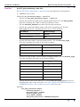
B - Output foliation points have the fields “ContactNumber,
X,Y,Depth,DipDirection,Dip” shown in the following example.
// Intrepid WormE 3D contact orientations, Projection: TMAMG54, Datum: AGD66
// Intrepid assumes the solutions are below a aero-survey drape surface (zero value),
with Z positive upwards
// This file also must be imported by Geomodeller along with the contacts, to define
enough constraints to create fault surfaces
Contact,Easting,Northing,Elevation,DipDirection,Dip,Polarity
Contact1,747693.8,8415176.1,-215.5, 246.0, 36.5, 1
Contact1,747086.2,8416655.0,-422.0, 253.0, 61.2, 1
Contact2,750123.0,8419553.1,-110.0, 229.0, 64.1, 1
•
C - Output limited fault radii so that each 3D worm can be treated as having
limited extent when rendered within Geomodeller, and allowing the user to
merge, delete, and decide on the fault network order
// Intrepid WormE 3D contact limited extents box, Projection: TMAMG54, Datum: AGD66
// Intrepid assumes the solutions are below a aero-survey drape surface (zero value),
with Z positive upwards
// This file also must be imported by Geomodeller along with the contacts, to define
enough constraints to create a limited fault surface
Contact,HorizontalRadius,VerticalRadius,InfluenceDistance
Contact1,5047.2,3310.0,1394.6
Contact2,4177.6,3310.0,1245.1
Contact3,8534.5,3310.0,997.3
Contact4,8801.9,3310.0,3025.5
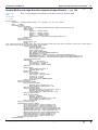
Geomodeller Project Import and fault network Creation
The process of bringing the womrs3D interface/foliation data into Geomodeller and
creating a Fault network is described. You need to also have a copy of the
Geomodeller tool available and open, ready to use. A very small example project is
distributed within the examples/geomodeller_projects/mlevel_example/
Library | Help | Top
© 2012 Intrepid Geophysics
| Back |